
Abstract
Hot dry rock is regarded as the clean energy of the future and is an important part of geothermal resources, with great research value and development prospects. The Weishan volcano, located in the northern part of the Wudalianchi volcanic group, was formed in the Pleistocene, and its age is only (0.57–0.31) ± 0.05 Ma. This area has a geothermal setting similar to but a younger age than that of the Fenton Hill volcano (formed 1.40–1.10 Ma) where a hot dry rock power project has operated since 1973. In this study, we used ambient noise tomography and magnetotelluric sounding methods to investigate deep heat sources beneath the Weishan volcano. The results show good geothermal conditions for hot dry rock formation in this region. A cooling magma chamber that might be the hot dry rock heat source is indicated in the upper crust at 6.5–13 km depth, with a volume of ∼200 km3. Our study suggests that the monzonitic granites of the Indosinian Xiaohongshan unit, which lies beneath the Late Cretaceous Nenjiang Formation and the Neoproterozoic-Early Cambrian Beikuanhe Formation, should be the main target for further hot dry rock geothermal energy exploration and development.
Keywords
Introduction
Under the triple pressures of energy depletion, economic development and CO2 emissions, finding and developing new clean energy sources have become an urgent task for our society. Many countries have focused on 150–650°C hot dry rock (HDR) buried at 3–10 km depths beneath the surface due to the advantages of great resources, wide distribution, zero pollution discharge, safety, good thermal energy continuity, high utilization efficiency and low cost (Brown, 1995). Since 1973, some countries such as the United States (1973), Japan (1980), France (1997), Germany (1987) and Australia (2003) have invested heavily in the HDR researches and have built a number of experimental ‘Enhanced Geothermal Systems’ (EGSs) extracting heat from the HDR that have even been incorporated into the national development plan (Jefferson et al., 2007) and achieved good results. In addition, processes for extracting heat from deep HDR have been achieved to varying extents (Xu et al., 2015). In April 2015, the US Department of Energy launched an HDR research plan named ‘Forefront Observatory for Research in Geothermal Energy’. The goals of the plan are to accomplish technological breakthroughs for HDR exploration and development through demonstration of HDR exploitation and to meet the green electricity demands of 100 million households in the United States, which is nearly 100 times higher than the output from current hydrothermal systems. Through this project, HDR resources would become representative of clean, reliable, flexible and renewable energy.
From the formation mechanism of the HDR, Cenozoic volcanic areas generally possess good heat source conditions and resource prospects due to the influence of magmatic activity. The HDR exploration and development is frequently focused at the edge of a crater or caldera, such as Fenton Hill in the United States and Hijiori and Ogachi in Japan, all of which show high geothermal gradients (Jefferson et al., 2007). These gradients occur because Cenozoic volcanic areas have cooling magma chambers that provide abundant heat for the HDR formation. Therefore, Cenozoic volcanic areas are favourable regions to explore for HDR resources.
Cenozoic volcanic activity is quite frequent in China, mainly distributed in two areas: one location is the Qinghai-Tibet Plateau and its surrounding areas, belonging to the Mediterranean-Himalayan volcanic tectonic belt; the another is the eastern North-northeast plain and mountainous region, which is an important component of the western Pacific volcanic chain (Liu, 1999; Li, 2003). The northeast volcanic area is much denser than the north China volcanic area, with approximately 690 volcanic cones distributed in Liaoning, Jilin, Heilongjiang and eastern Inner Mongolia Provinces covering a range of approximately 150 × 104 km2. Therefore, the study of HDR in this Cenozoic volcanic area is of great significance.
For this study, we selected one of the youngest volcanic group in China, the Wudalianchi volcanic group. By collecting and analysing regional geological conditions, rock geochemistry and deep gas and regional geophysical data, we estimated the possibility of HDR presence in the Weishan area. In addition, we used deep magnetotelluric sounding (MT), gravity and magnetic prospecting, natural earthquakes and other methods to detect deep heat sources. This study not only has collected several clues for further detailed exploration in this area but also provides a research reference for other Cenozoic volcanic areas.
Geological setting
The Wudalianchi volcanic group is located in the north-central part of Heilongjiang Province on the northeastern margin of the Songnen Plain and consists of 14 volcanoes. The Weishan volcano is located in the northernmost part of the volcanic group (Figure 1). As a result of long-term volcanic activities, the Wudalianchi area has developed many mineral springs, which compose one of the ‘three cold springs in the world’ with the French Vichy and Russian North Caucasus. Laoheishan and Huoshanshan volcanoes erupted in 1719 and 1720–1721, respectively. They have been dormant for less than 300 years and may still retain magmatic heat. Looking back at the brief history of geothermal geological exploration in the Wudalianchi area, the geothermal survey in the 1970s, the thermal infrared scan in the 1980s and the electromagnetic detection during the period of 1996–2000 did not yield clear conclusions. In recent years, different researchers have renewed the scenario for ‘residual heat of magma’ in the Wudalianchi area via the citation of first-hand data or interpretation from different angles (Lu, 2013), but the latest original information is still lacking.
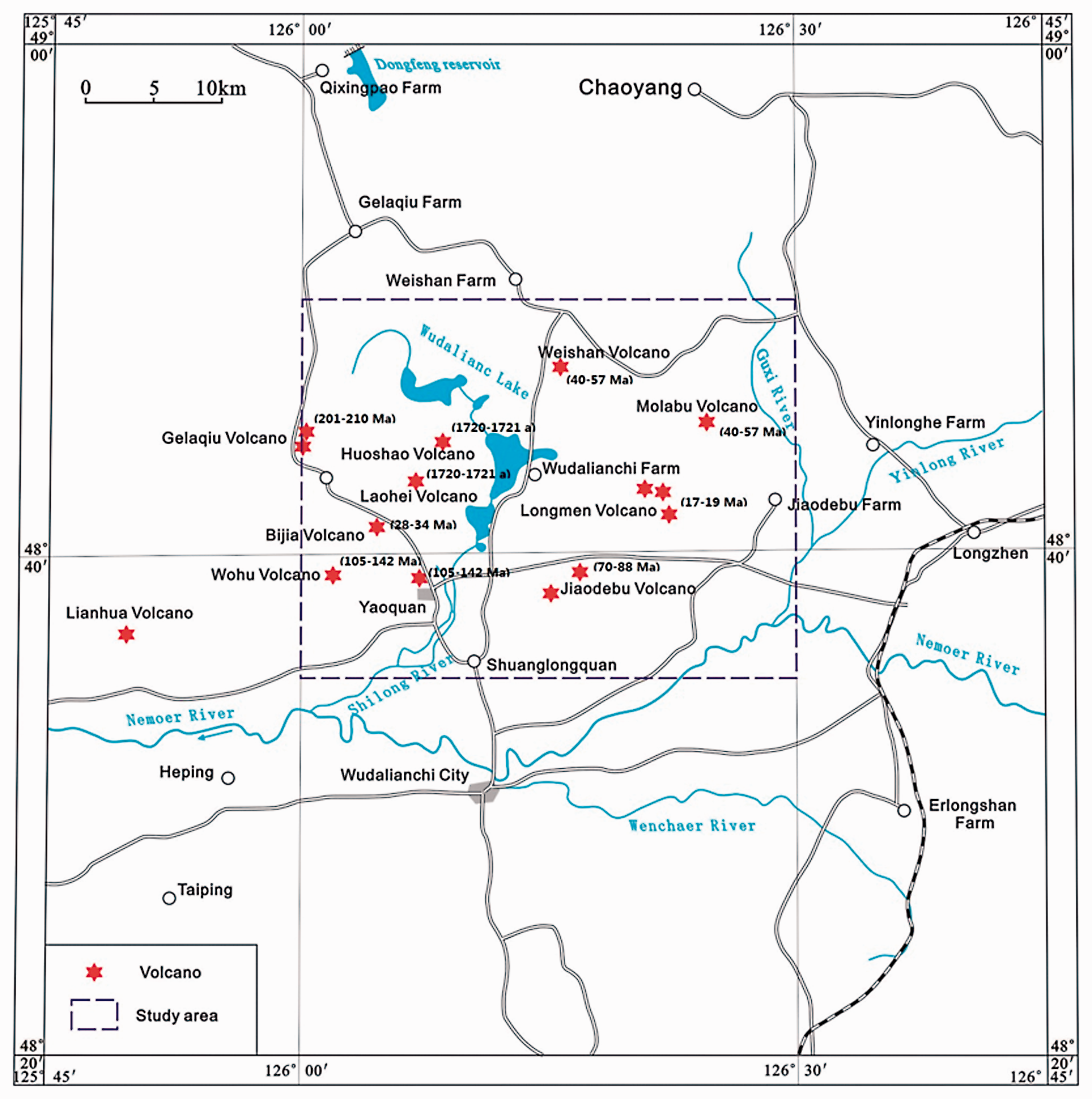
The calderas in the Wudalianchi volcanic field and their eruption time.
The Weishan volcano is a single-stage volcano and covers an area of approximately 112 km2. Its volcanic cone located at the centre and the lava platform present as a belt are quite typical (Figure 2). This volcanic cone has an elevation of 516.4 m, a diameter of 750 m, an inner diameter of 325 m and a caldera of 56 m depth. The caldera of the Weishan volcano is oval-shaped with a flat top, and the slope of the volcanic cone is 25°–30°. There are entered ditches on the surface of the Weishan volcano, stone dragon lava has grown in the north, west and east directions and a wide lava shield terrace is located on the periphery. The surface of the Weishan volcano is mainly composed of the Luweishan basalt (βQ2w), middle-late Pleistocene Harbin Formation (Q2–3h), early Holocene high floodplain accumulation layer (Q41) and late Holocene low floodplain accumulation layer (Q42). The Jiuquwan (T3Jq) and Xiaohongshan units (T3Xh), intrusions formed during the Late Triassic, are exposed in the western and north-eastern parts of the Weishan volcano, respectively.
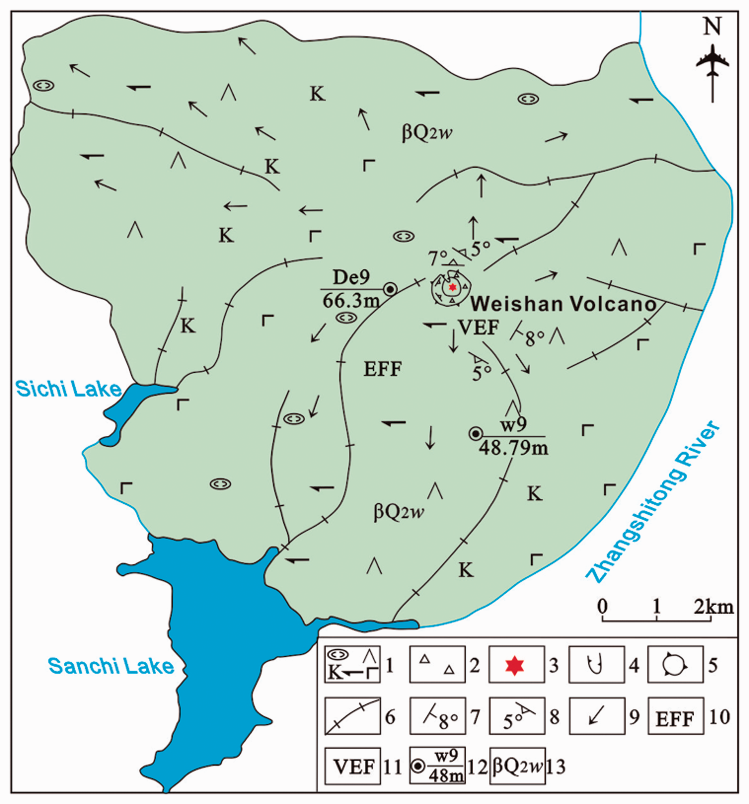
Tectonic map of the Weishan volcano during the middle Pleistocene.
Due to the volcanic lava covering the fault structure and to the healing process during lava intrusion, only a few high-angle normal and strike-slip faults with small scale and short extension have developed at the surface of the Weishan area. Speculatively, the Weishan volcano may be located at the intersection of NW- and NE-trending faults, the former through Weishan and presumed to be an SW concealed tensional fault and the latter as the dominant fault perhaps present as an SE concealed torsional fault (Wang and Yu, 2000; Figure 3).
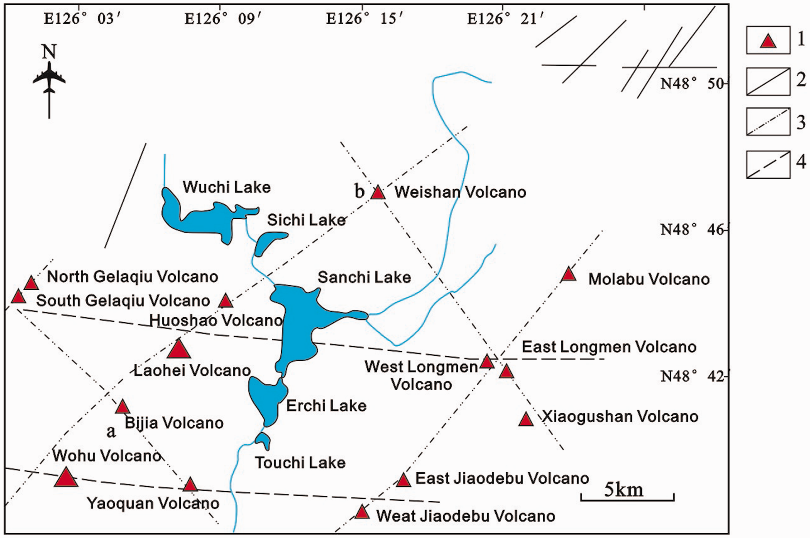
Distributions of volcanoes and faults in the Wudalianchi area (Xiang et al., 2010).
The K–Ar age of volcanic rocks from the Weishan period is (0.57–0.31) ± 0.05 Ma (Qiu et al., 2003), and the volcanic activity of the middle Pleistocene Weishan volcano occurred 0.57–0.31 Ma, which is younger than the Cretaceous Valles volcano of the Fenton Hill HDR project. Therefore, the Weishan area may have the potential for developing a cooling magma chamber.
According to regional geological conditions, the Wudalianchi area is located in the Cenozoic K-rich volcanic belt within the Xiaogulihe-Kolo-Wadalianchi-Erkeshan area and belongs to the intracontinental Cenozoic volcanic group (Gong, 1997; Liu, 1980; Shao et al., 2008; Qiu et al., 1991), whose volcanic activities continued from 2.07 Ma to 1721 AD. During the Quaternary, the lithosphere extension and thinning have triggered partial melting of a mantle source magma and formed K-rich magma, which contributed to the formation of the Wudalianchi volcanic group. The trend of magma evolution indicates that the Wudalianchi rift zone will continue to spread without collapse (Shao et al., 2008). Therefore, the Wudalianchi area is likely to contain a residual or cooling magma chamber, whose heat source mechanism is a magma waste heat type. Under current techniques and economic conditions, if there is a cooling magma chamber within the depth of drilling, HDR may exist in the area.
From the exploration results that predecessors have achieved, the Wudalianchi volcanic field has the potential for a cooling magma chamber. For instance, the MT conducted by Yan et al. (1997, 2006) showed a low-resistance trap beneath Laoheishan Mountain, which was tentatively identified as a cooling magma chamber. Zhang et al. (2014) used teleseismic broadband waveform data to find a low-velocity anomaly under the Wudalianchi area and inferred that the Wudalianchi volcanic field has a shallow heat source, i.e. that it is a non-deep-sourced volcano (Zhang, 2014). Additionally, Li et al. (2016) concluded that CO2 gas in spring water across the Wudalianchi area was derived from a degassing process during the cooling of volcanic rocks in the Wudalianchi area and measured the concentration of CO2 to estimate the possibility of a cooling magma chamber beneath the Weishan volcano and Wudalianchi farm.
Method
In this study, two geophysical methods, seismic ambient noise tomography and MT, are used to probe magma chambers. Experience in the geophysical exploration of high-temperature geothermal fields has shown that gravity, natural magnetism, MT and seismic ambient noise tomography are the preferred methods for HDR exploration. The low-speed and low-resistance properties of high-temperature rocks mean that the combination and mutual correction of seismic ambient noise tomography and MT are quite suitable for geophysical exploration of these rocks in the deep earth.
Seismic ambient noise tomography
The partial melting of rocks and the existence of magma chambers in the crust usually result in S-wave low-speed anomalies. However, for significant anomalies, the effect of temperature rise may be superimposed (McKenzie et al., 2005; Priestley and Kenzie, 2006). When temperature rises significantly, the S-wave speed of rocks decreases notably, which causes relatively low-speed S-wave anomalies in seismic tomography results.
To describe the spatial distribution of the Weishan volcanic magma chambers, we laid five broadband seismometers with frequency bands ranging from 30 s to 100 Hz and 38 short-period seismometers with 5 s to 200 Hz in the Wudalianchi volcanic field. These seismometers constituted a dense coverage of the entire Wudalianchi area with an average spacing of 5 km (Figure 4). Because of the low and uneven seismic activity in this area, we chose the seismic ambient surface wave tomography method for this study, which does not require seismic events or artificial seismic sources. After seismic waveform data pre-processing and cross-correlation calculation, the noise cross-correlation function between stations is obtained, and we utilize the multi-filter method to extract the Rayleigh surface group velocity dispersion curve in a 0.8–8 s period. Based on the surface wave tomography method, we obtain the distribution of the Rayleigh surface group velocity at different periods in the Wudalianchi area and then invert these data to acquire the 3-D fine velocity structure of S-wave speeds down to 15 km depth in this volcanic area.
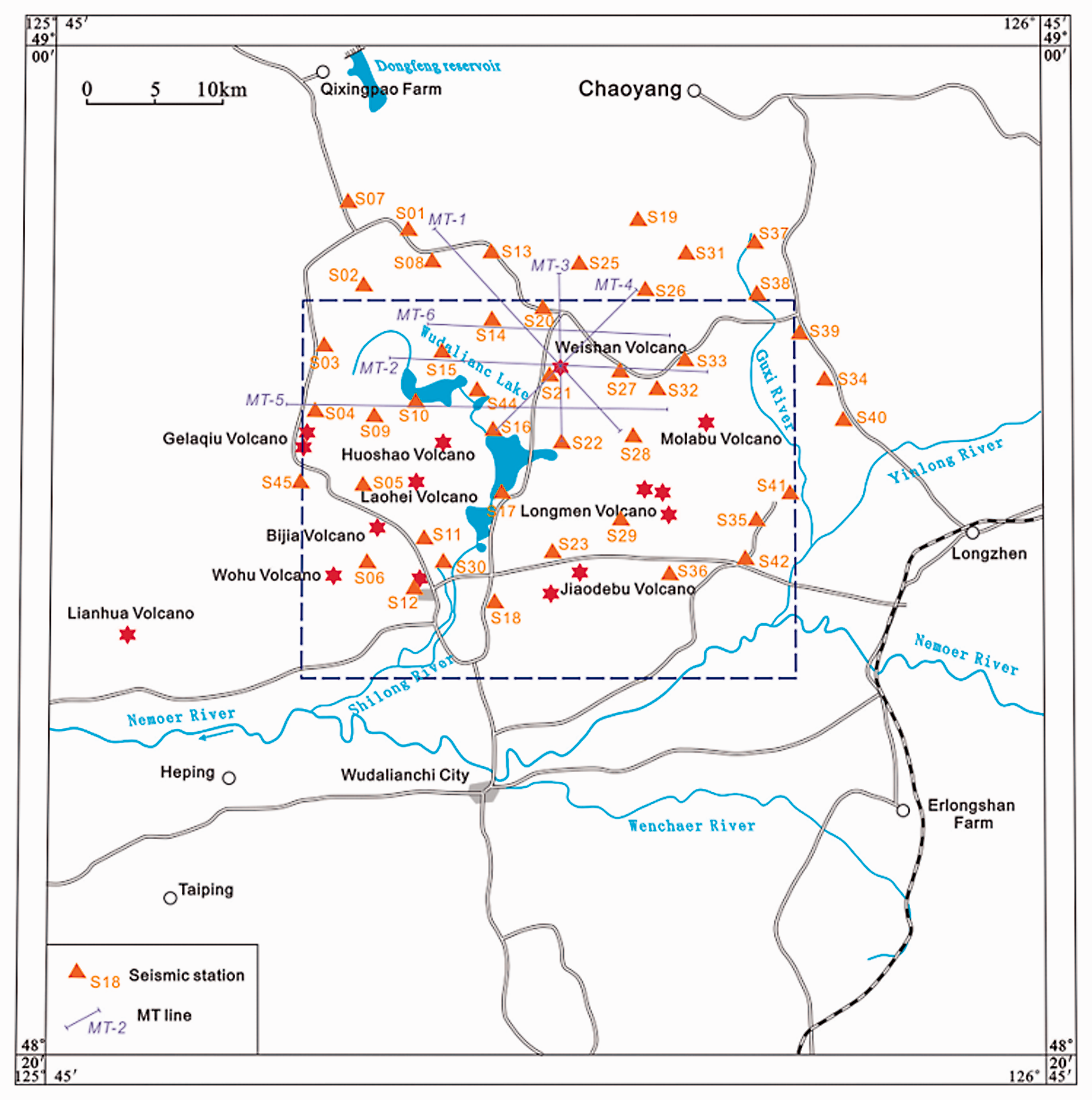
Seismic stations and MT lines distribution.
Magnetotelluric sounding
The MT method is one of the frequency-domain electromagnetic sounding methods. It first calculates the wave impedance of underground media by observing the horizontal electric field (Ex, Ey) and magnetic field components (Hx, Hy, Hz) of the Earth’s natural alternating electromagnetic field and then calculates the apparent resistance and impedance phase from the wave impedance in order to invert for the distribution of electrical characteristics of a geological body. At present, the theory, instrumentation, data processing and interpretation techniques of the MT method are relatively mature; thus, this method is widely used in various fields of geological exploration.
In this study, a total of 6 MT lines crossing the Weishan volcano in different directions and 101 physical points were completed around the Weishan volcano (Figure 4). The spacing between adjacent points is 200–2000 m with 50 m spacing of electrodes, and the sounding data of two physical points can be obtained simultaneously in each collection period. According to the exploration depth, geological conditions in this area and field tests, the sample time for a single point is 24 h. By using the SSMT200 and MTEDITOR software produced by the Phoenix Corporation, Canada, to complete data processing, we perform Fourier transforms for the timing files and ROBUST processing for the frequency files and then compile the resulting spectrum files to output as EDI type for later data inversion. Inversion is completed by using the Pioneer software compiled by Xiaobin Chen, including processing the apparent resistivity and impedance phase in both directions of XY and YX and performing one-dimensional RhoPlus and one-dimensional adaptive regularization inversion for the data sets in two directions. Two-dimensional nonlinear conjugate gradient inversion is then carried out to obtain resistivity/conductivity profiles.
Results
Results from seismic ambient noise tomography
The research from Kern (1982) shows that an increase in rock temperature leads to a decrease in the speed of seismic waves. For crustal basalt under pressure of 6 kb, a temperature increase to 100°C causes up to a 2% reduction in the speed of S-waves and 1% for P-waves. When temperature increases to 500–600°C, the speeds of both waves might decrease more rapidly because of the partial melting of rocks. Considering the error in imaging results and many other factors such as mineral composition and fluid and gas content in addition to partial melting and temperature increase that affect the seismic wave velocity, it is reasonable to delineate the spatial distribution of magma chambers by utilizing the anomalous areas with larger amplitudes of low seismic velocity.
The results of some studies have shown that a magma chamber exhibits a significant low-velocity seismic anomaly. For instance, the P-wave travel time 3-D seismic tomography of Yellowstone National Park in the United States shows that the magma chambers in the upper crust are distributed at depths of 5–17 km. Although the proportion of the magma chambers estimated by different methods varies greatly, ranging from 2 to 32%, the presence of all magma chambers causes significant P-wave low-velocity anomalies in the results of seismic tomography (Farrell et al., 2014; Li, 2016).
According to the overall tomography results from the Wudalianchi volcanic field, the magma chambers in the Weishan area show significant S-wave low-speed anomalies. The average S-wave velocity of 3.0 km/s in the Weishan area is taken as the background value. For more conservative considerations, if the S-wave is reduced by 10% to 2.7 km/s, we take this value as the upper limit for delineating the spatial distribution of the magma chambers in this area. Figure 5 shows that the average of upper boundary of the magma chambers is approximately 6.5 km which is referred to low-speed S-wave anomalies. On the north–south profile (B–B′), the magma chambers’ main body is directly below the Weishan volcano; on the east–west profile (A–A′), they are on the west side; on the northwest-oriented profile (D–D′), northwest side; and on the northeast-oriented profile (C–C′), southwest side. Therefore, below 6.5 km depth, magma chambers are mainly located towards the west direction below the Weishan volcano.
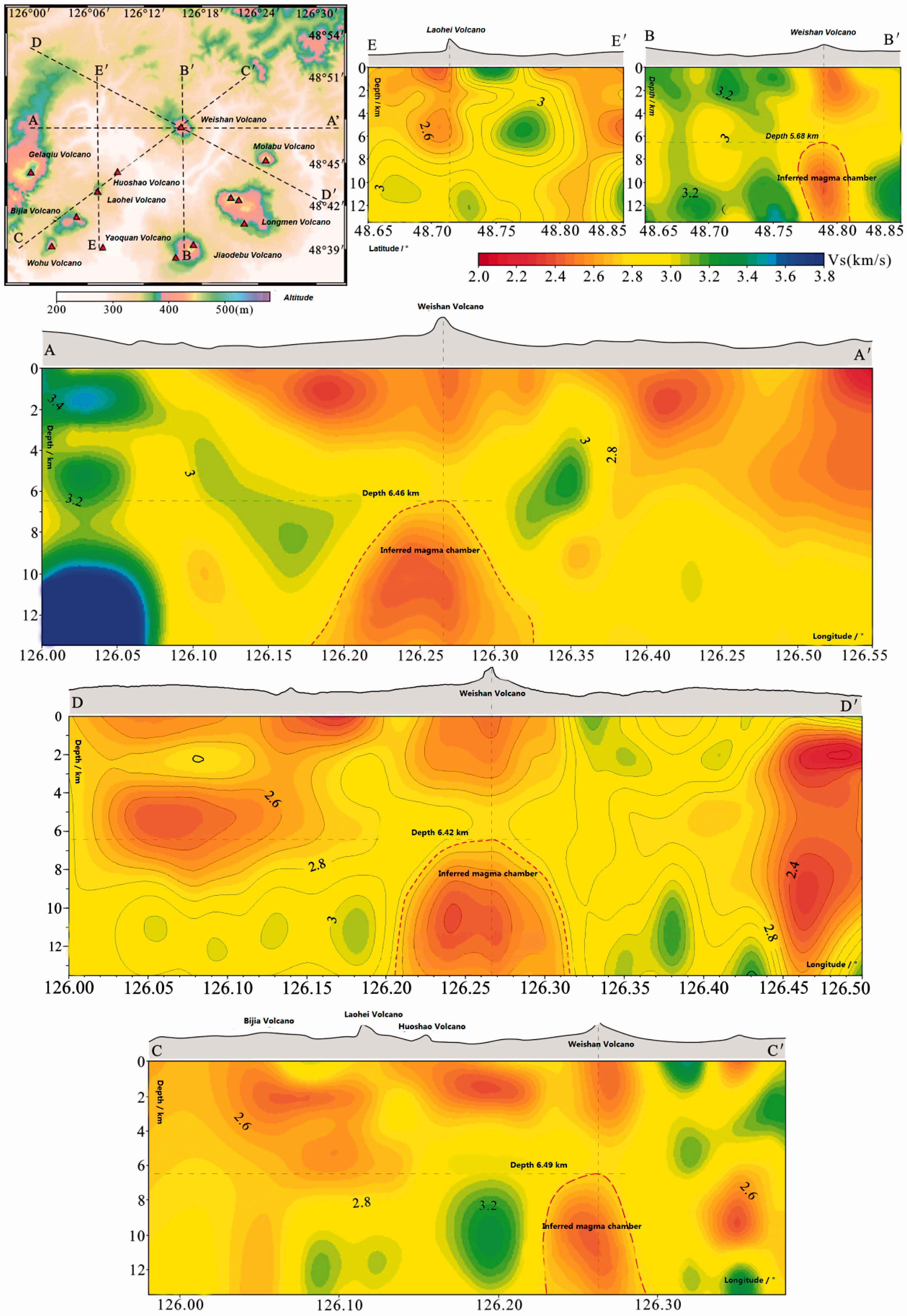
Figures illustrating the distributions of S-wave velocity structures in vertical profiles (black lines in every profile are topographic lines).
Results from MT
According to laboratory results, as the rock temperature increases, the rock resistivity decreases. Under the premise of excluding the influence of lithological changes on the resistivity value, the decrease in apparent resistivity value could be attributed to the influence of temperature increase. The data show that at normal temperature, the resistivity of the monzonitic granite of the Indosinian Xiaohongshan unit (T3Xh) is 103–105, and the apparent resistivity at normal temperature of the basalt of the Weishan volcanic period is 102–105. For more conservative considerations, we take rocks whose apparent resistivity is lower than 2
According to the results of 2-D nonlinear conjugate gradient inversion using MT profiles (Figures 6 and 7), the depth of the upper boundary of the high-conductivity/high-temperature rocks on each profile with apparent resistivity values is less than 2 Ω m is 5 km. It is speculated that the local structure is affected by faults and that the high-conductivity/high-temperature rocks invaded along fracture zone to as shallow as 3 km and reached a steady state with surrounding rocks at this depth. The MT single-point survey curve and diagram show that at 2 km depth below the west side of the Weishan volcano, the resistivity decreases below 2 Ω m; this position is the most suitable place to drill a well for HDR resource exploration.
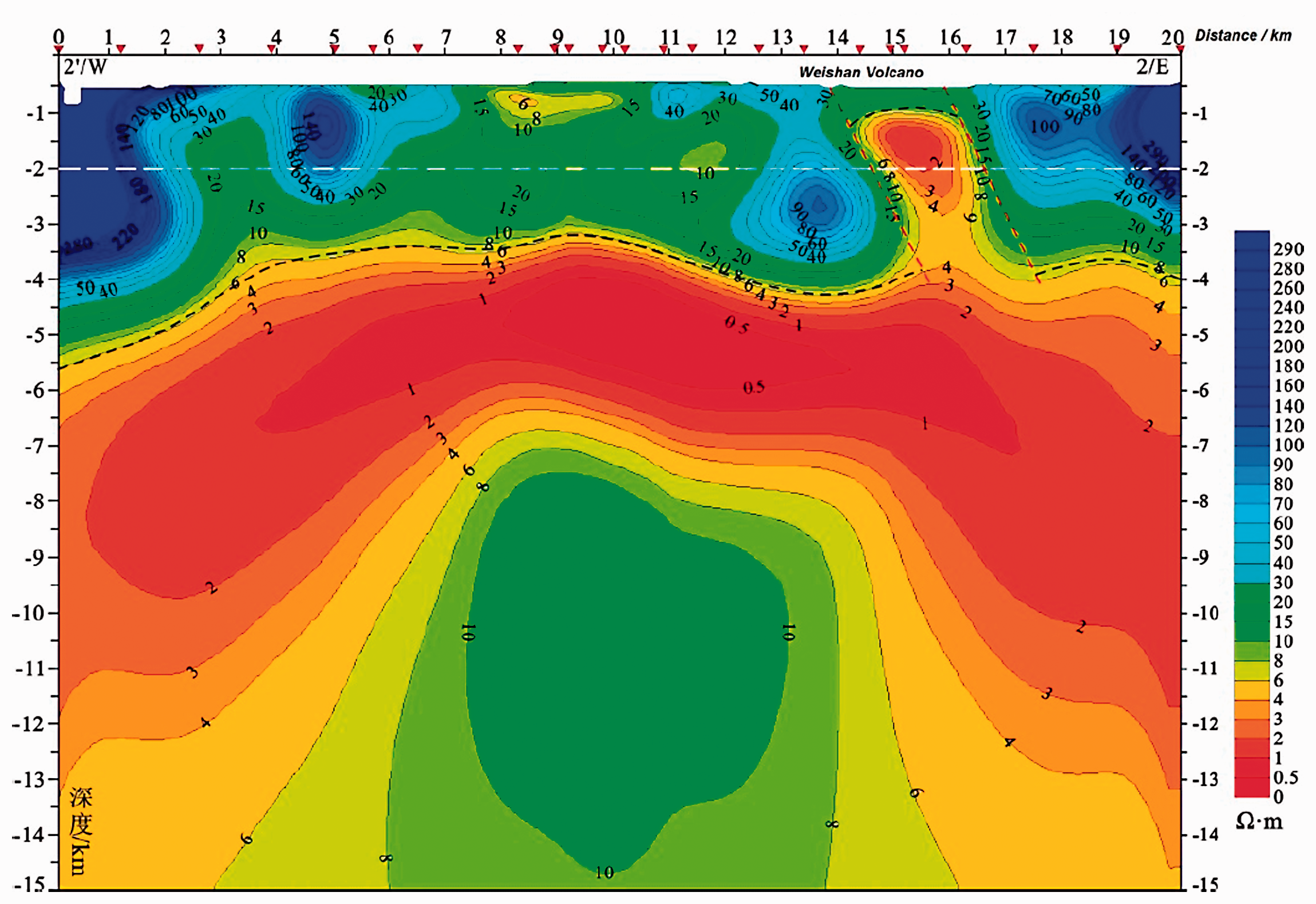
E-W profile (MT-2) exploration results through the Weishan volcano area (the red triangles on the top of cross sections are the positions of MT site).
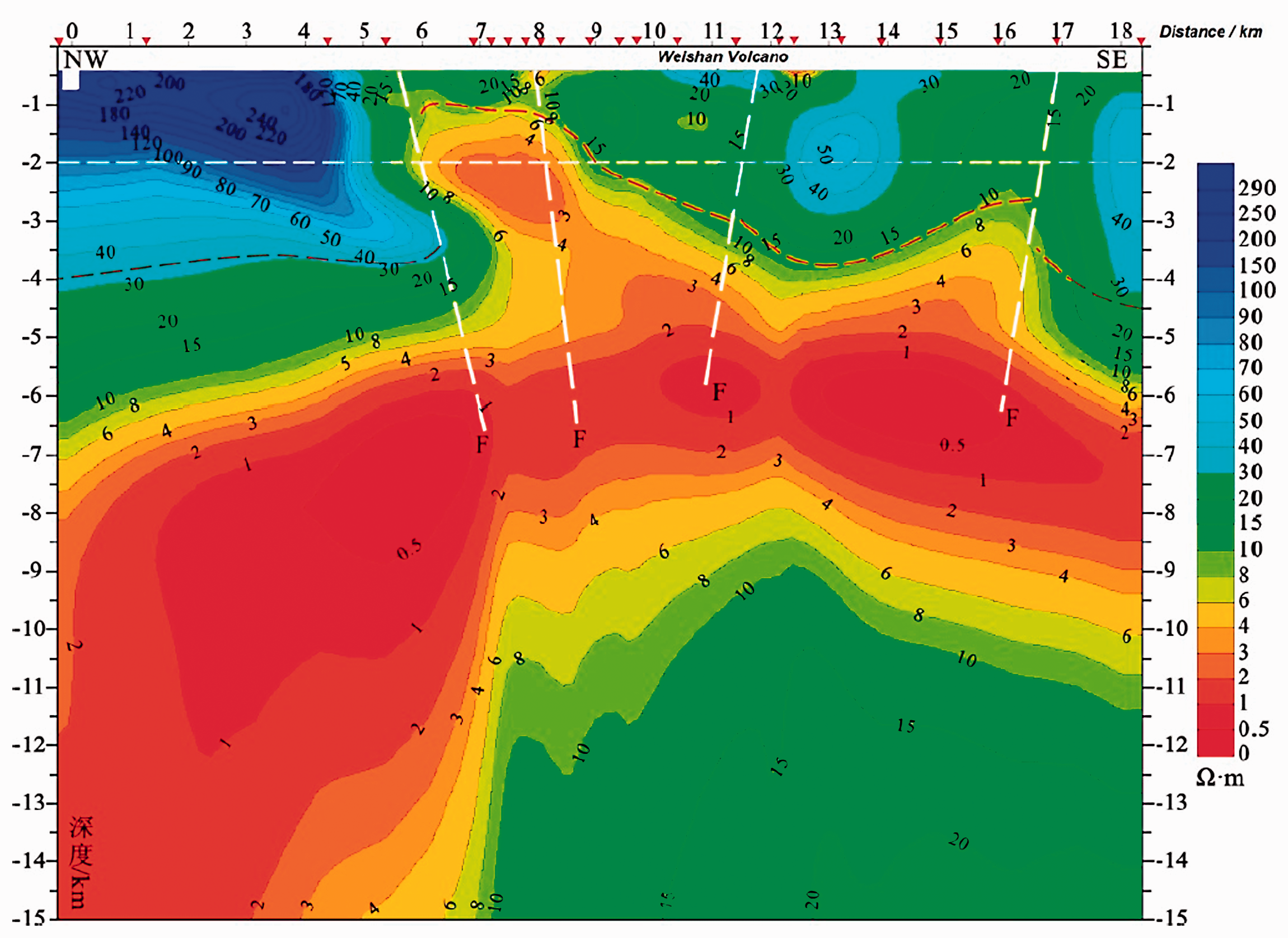
NW-SE (MT-1) profile exploration results through the Weishan volcano area (the red triangles on the top of cross sections are the positions of MT site).
Analysis of the prospect for HDR resources
In general, a region could become a valid HDR resource exploration and development zone if certain conditions are satisfied. The first condition is accessibility, which means that people usually seek to obtain more geothermal energy with less drilling engineering. Second, the distribution of HDR resources should contain sufficient heat storage area and the heat storage capacity of rock itself should be sufficient. Thus, before implementing HDR drilling engineering in the Weishan volcano and the Wudalianchi area, it is necessary for us to make reasonable inferences about the prospect for HDR resources according to geological and geophysical exploration data.
The Weishan volcano is located in the centre of the dense seismic observation arrays, so the resolution and reliability of the resulting velocity structure are relatively high. In comparison, there would be decreases in the resolution and reliability of the deep velocity structure along the edges of these seismic observation arrays. In this paper, we focus on the deep characteristics of the magma chambers in the Weishan volcano area. The upper limit for S-wave speed, 2.7 km/s (10% of the low-speed S-wave anomalies), is used to delineate the low-speed S-wave anomalies; then, we use Voxler, a visualization software, to show the distribution of these magma chambers and calculate their geometric parameters at the same time (Figure 8).
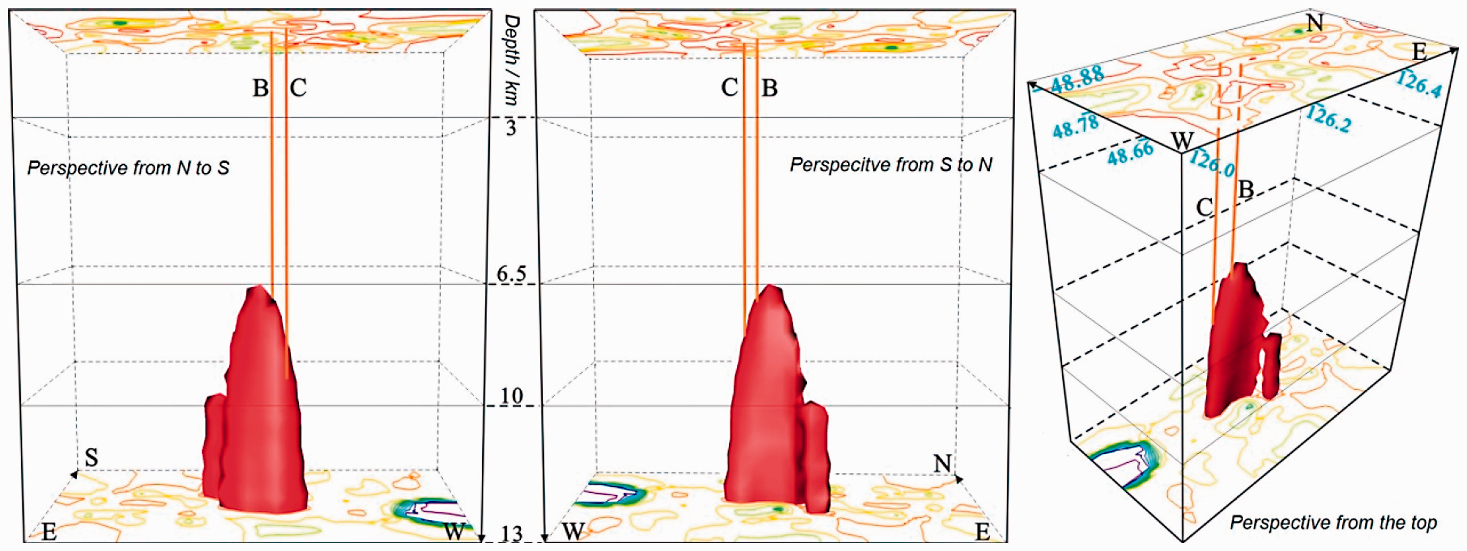
3-D models for cooling magma chambers below the Weishan volcano area.
On the horizontal surface at 7 km depth, the north–south magma chambers in the Weishan volcano area are 2.2 km at their widest point, 2.3 km long from east to west and 3 km long from northwest to southeast, with an area of approximately 2.5 km2. For the 8 km surface, these characteristics are 4.2 km, 4.7 km, 5.5 km and 13 km2, respectively. For the 9 km surface, the values are 6.9 km, 6.3 km, 8.6 km and 21 km2, respectively; for the 10 km surface, 7.7 km, 9.1 km, 11 km and 29 km2; for the 11 km surface, 8.4 km, 10 km, 11.8 km and 31.7 km2; for the 12 km surface, 8.5 km, 10.7 km, 12.2 km and 34.8 km2; and for the 13 km surface, 8.7 km, 11.4 km, 12.7 km and 35 km2.
The magma chambers in the Weishan volcano area start to appear at a depth of 6.5 km, and the horizontal area increase to 13 km2 at a depth of 8 km, to 29 km2 at 10 km and to 35 km2 at 13 km. This area strikes northwest–southeast to the east of the Weishan volcano and nearly east–west to the west of the Weishan volcano. The magma chambers are generally distributed in the northwest–southeast direction with a larger west part and smaller east part, like a tadpole, and vertical dips. These magma chambers constitute a strong heat source for HDR resources in the Weishan volcano area, which indicates a certain prospect for HDR resources in the Weishan area of Wudalianchi.
Based on recent 3–6 km drilling depths from HDR resource exploration, the data at 3–6 km depths are used to draw a 2-D map (Figure 9) of apparent resistivity based on inversion data of 6 MT profiles. This map shows only the trend of the distribution because of the irregular arrangement of MT profiles and the insufficient constraint conditions in mathematic interpolation.
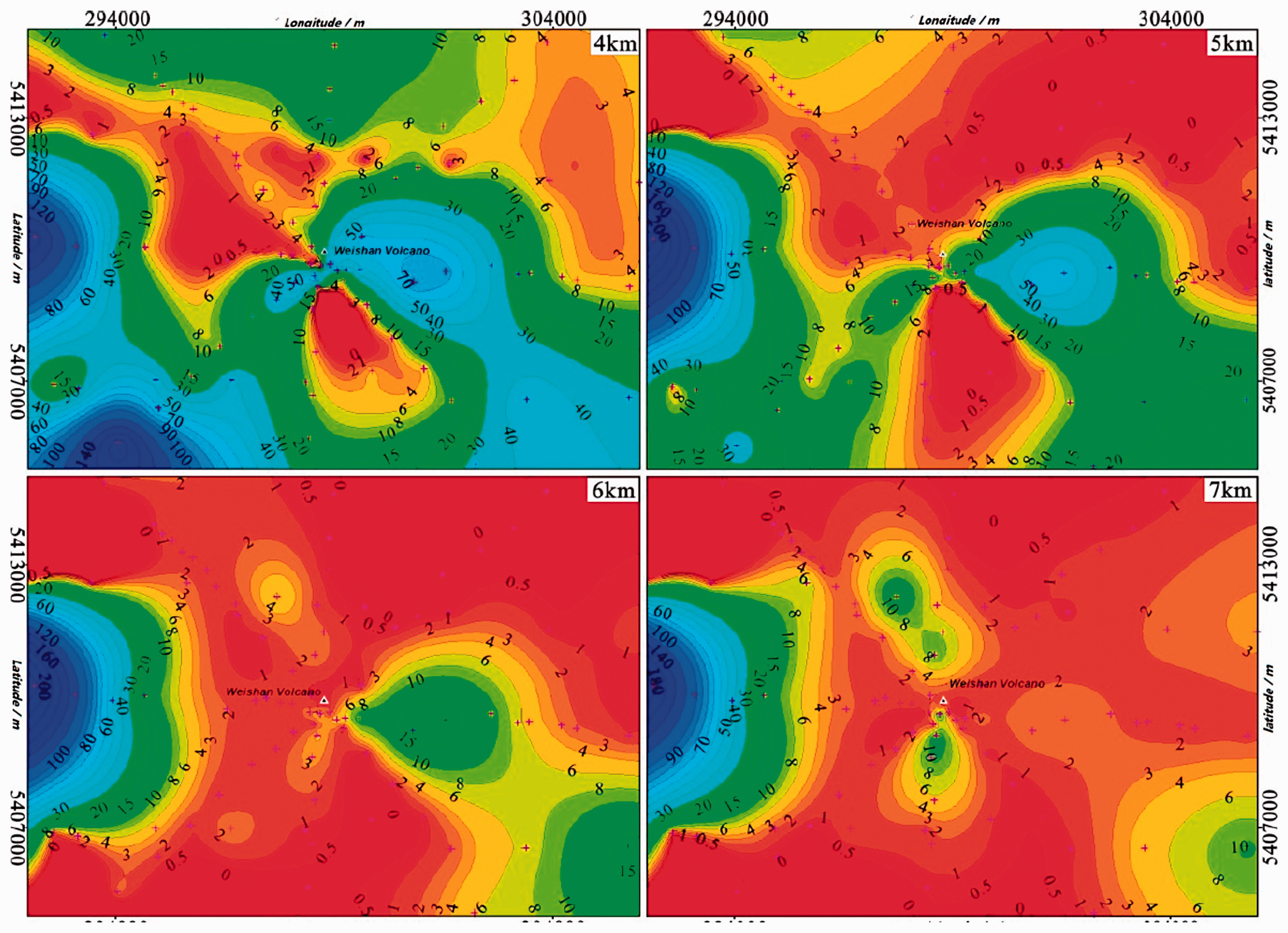
The 2-D maps of the trends of apparent resistivity (Ω m) under the Weishan volcano.
Figure 9 shows that the apparent resistivity of the Weishan volcano area gradually decreases in the depth range of 3–6 km, but there are large differences in different regions. Above 3 km depth, low-resistivity blocks less than 2 Ω m appear scattered to the northwest and east of the Weishan volcano, which are presumed to be the results of the intrusion of deep high-temperature rocks along structural fracture zones. Except for the southwestern west, the apparent resistivity is in the range of 10–30 Ω m. These values presumably reflect sedimentary strata/metamorphic strata with high mud content such as Cretaceous or Precambrian and argillaceous sandstone. From 4–6 km, these blocks gradually merge into one piece, and below 6 km, the resistivities of almost all areas are less than 2 Ω m. Based on the above results, we can conclude that the Weishan volcano area within the Wudalianchi volcanic field has good potential for HDR resources.
Conclusions
In this study, we analysed the potential deep heat source in the Wudalianchi volcanic field based on the seismic ambient noise tomography and MT methods. The following conclusions were obtained.
Based on seismic ambient noise tomography exploration, an S-wave velocity of 2.7 km/s (S-wave low-velocity anomaly with an amplitude of 10%) is used as the upper limit of the magma chamber around the Weishan volcanic area. The upper burial depth of the magma chamber is approximately 6.5 km, and the horizontal area extends to 13, 29 and 35 km2 corresponding to depths of 8, 10 and 13 km, respectively. The overall shape of the magma chamber is a nearly upright dike, which provides a heat source for HDR storage in the Weishan area. This result indicates that the Weishan area in Wudalianchi has the advantage of storing HDR resources.
According to the MT survey, we infer that there is high-temperature rock with apparent resistivity less than 2 Ω m and that the burial depth of the upper boundary is approximately 5 km. Apparent resistivity deeper than 6 km in the Weishan area is almost entirely lower than 2 Ω m, and the western side of this area is a feasible location for HDR exploration and development, which suggests that the Weishan area possesses an excellent prospect for HDR resources.
Argillaceous rocks of the Late Cretaceous Nenjiang Formation (K2n) and Neoproterozoic-Early Cambrian Beikuanhe Formation (Pt3Є1b) in the Weishan area constitute good thermal insulation capping the HDR resources. In addition, the monzonitic granite of the Xiaohongshan unit (T3Xh) and the Weishan basalt are the target layers in exploration for HDR resources, and the Weishan magma chamber may dominate the heat source for HDR.
The carbonaceous slate (graphitized) sandwiched between Neoproterozoic rock and the Lower Cambrian Beikuanhe Formation is conductive, which may be the main uncertainty factor in the geomagnetic exploration and interpretation in this area. Another uncertainty factor is that no high-temperature manifest has been detected so far, deep drilling work is needed to prove the geophysical interpretation. Therefore, conducting detailed geothermal geological survey and geophysical exploration in the Weishan area is recommended to select favourable areas for drilling verification.
Footnotes
Acknowledgements
We would like to thank Mr. Wang Yunpeng, Mr. Zhang Fenglong and Mr. Guo Jianqiang for their valuable discussion.
Declaration of conflicting interests
The author(s) declared no potential conflicts of interest with respect to the research, authorship, and/or publication of this article.
Funding
The author(s) disclosed receipt of the following financial support for the research, authorship, and/or publication of this article: This study was supported by National key R&D program of China (2018YFC0604305), China Geological Survey project (DD20179621), and science and technology research project of Jilin Provincial Department of education (JJKH20170807KJ).