
Abstract
Geothermal fields in coal-bearing strata significantly influence coal mining and coalbed methane accumulation and development. Based on temperature data from 135 coalfield exploration boreholes and thermophysical tests of 43 rock and coal samples from the Upper Permian coal-bearing strata of the Bide-Santang basin in western Guizhou, South China, the distribution of terrestrial heat flow and the geothermal gradient in the study area are revealed, and the geological controls are analysed. The results show that the thermal conductivity of the coal-bearing strata ranges from 0.357 to 3.878 W (m K)−1 and averages 1.962 W (m K)−1. Thermal conductivity is controlled by lithology and burial depth. Thermal conductivity progressively increases for the following lithologies: coal, mudstone, siltstone, fine sandstone, and limestone. For the same lithology, the thermal conductivity increases with the burial depth. The present geothermal gradient ranges from 15.5 to 30.3°C km−1 and averages 23.5°C km−1; the terrestrial heat flow ranges from 46.94 to 69.44 mW m−2 and averages 57.55 mW m−2. These values are lower than the averages for South China, indicating the relative tectonic stability of the study area. The spatial distribution of the terrestrial heat flow and geothermal gradient is consistent with the main structural orientation, indicating that the geothermal field distribution is tectonically controlled at the macro-scale. This distribution is also controlled by active groundwater, which reduces the terrestrial heat flow and geotemperature. The high geothermal gradient in the shallow strata (<200 m) is mainly caused by the low thermal conductivity of the unconsolidated sedimentary cover. The gas content of the coal seam is positively correlated with terrestrial heat flow, indicating that inherited palaeogeothermal heat flow from when coalbed methane was generated in large quantities during the Yanshanian period due to intense magmatic activity.
Introduction
The earth’s geothermal field is produced by the effect of the earth’s internal heat on shallow crustal rocks with different heat conductivity (Chen et al., 1984), and it has been attracting increased attention from large institutional, industrial, and scientific interests in order to evaluate the potential and feasibility of geothermal energy production (Chelle-Michou et al., 2017; Galgaro et al., 2014; Gondal et al., 2017; Tsuchiya and Yamada, 2017; Walsh et al., 2017). In coal-bearing strata, the geothermal field significantly influences coal mining and coalbed methane (CBM) accumulation and development (Qin et al., 2012a, 2012b). The present-day geothermal field is significant for coal and CBM exploration and exploitation, geothermal resources prediction, and geological hazard prevention. Present-day geothermal research is focused on the factors controlling the distribution of formation temperature, geothermal gradient, and terrestrial heat flow (Deng et al., 2012; Jiang et al., 2016; Pascal, 2015; Reiter, 2014; Tanikawa et al., 2016) and has recently received considerable attention related to the exploration and exploitation of coal, petroleum, and natural gas (Feng et al., 2017; Isaev et al., 2014; Kuzielová et al., 2017; Li et al., 2017; Liu et al., 2016; Safari et al., 2017). Temperature is one of the primary factors controlling hydrocarbon generation, sediment diagenesis, migration of hydrocarbons, and pore fluids (Nwankwo, 2007).
Coal and CBM resources are widely abundant in western Guizhou Province, South China, and mainly occur in the Upper Permian coal-bearing strata. Guizhou Province is considered to be an important region for CBM development in South China, and the Bide-Santang basin is one of the most promising blocks with extremely abundant coal and CBM resources and reservoir physical properties (Qin et al., 2012a). Some CBM wells in the Bide-Santang basin have produced industrial-scale gas flow, indicating a considerable prospect for CBM development (Guo et al., 2017).
During previous coal and CBM exploration, large amounts of geothermal data were obtained, but few studies have focused on the geothermal field and terrestrial heat flow in western Guizhou. Nor has there been much focus on thermal and physical rock properties, leaving the geothermal field distribution and the factors controlling it unrevealed. With the exhaustion of shallow resources, coal mining will occur at greater depths, which will be accompanied by the problems of high geotemperature and the risk of gas outburst. Additionally, the CBM occurrence and production in deep formations are significantly influenced by geothermal fields (Qin and Shen, 2016).
Therefore, an urgent need exists for research on the geothermal field of the coal-bearing strata in western Guizhou and its influence on CBM occurrence. In this study, the Bide-Santang basin in the Zhina coalfield, western Guizhou was selected as the research area, and geothermal data were collected from 135 boreholes in 16 coal exploration areas. The thermal conductivity of 43 coal and rock samples was tested to identify and analyse the main controls on the distribution of the present geothermal gradient and terrestrial heat flow. This study will provide insights into the conditions of CBM accumulation and development. We also expect this study to fulfil the need for research on the geothermal field in the study area and provide references for the efficient and safe development of coal and CBM resources in the Upper Permian strata of western Guizhou.
Geological setting
The Zhina coalfield is one of the most important areas of anthracite coal accumulation in South China and is located in the central–western part of Guizhou Province (Figure 1(a) and (b)). The western edge of the Zhina coalfield is bounded by the NW-trending Ziyun-Liupanshui fault, the north is bounded by the EW-trending Liupanshui-Wengan fault, the southeast is bounded by NE-trending Shizong-Guiyang fault, and the NS-trending Zunyi-Huishui fault lies to the east of the Zhina coalfield. The Zhina coalfield is located in a tectonic triangle surrounded by the four peripheral faults, and its tectonic characteristics are significantly controlled by the faults (Figure 1(b)). The structures in the coalfield are predominantly NW- and NE-trending. NW-trending structures are primarily located in the west, and NE-trending structures are widely distributed in the eastern and middle parts of the coalfield. NS-trending structures occur only along the eastern margin, and EW-trending structures occur only in the northwest (Figure 1(c)).
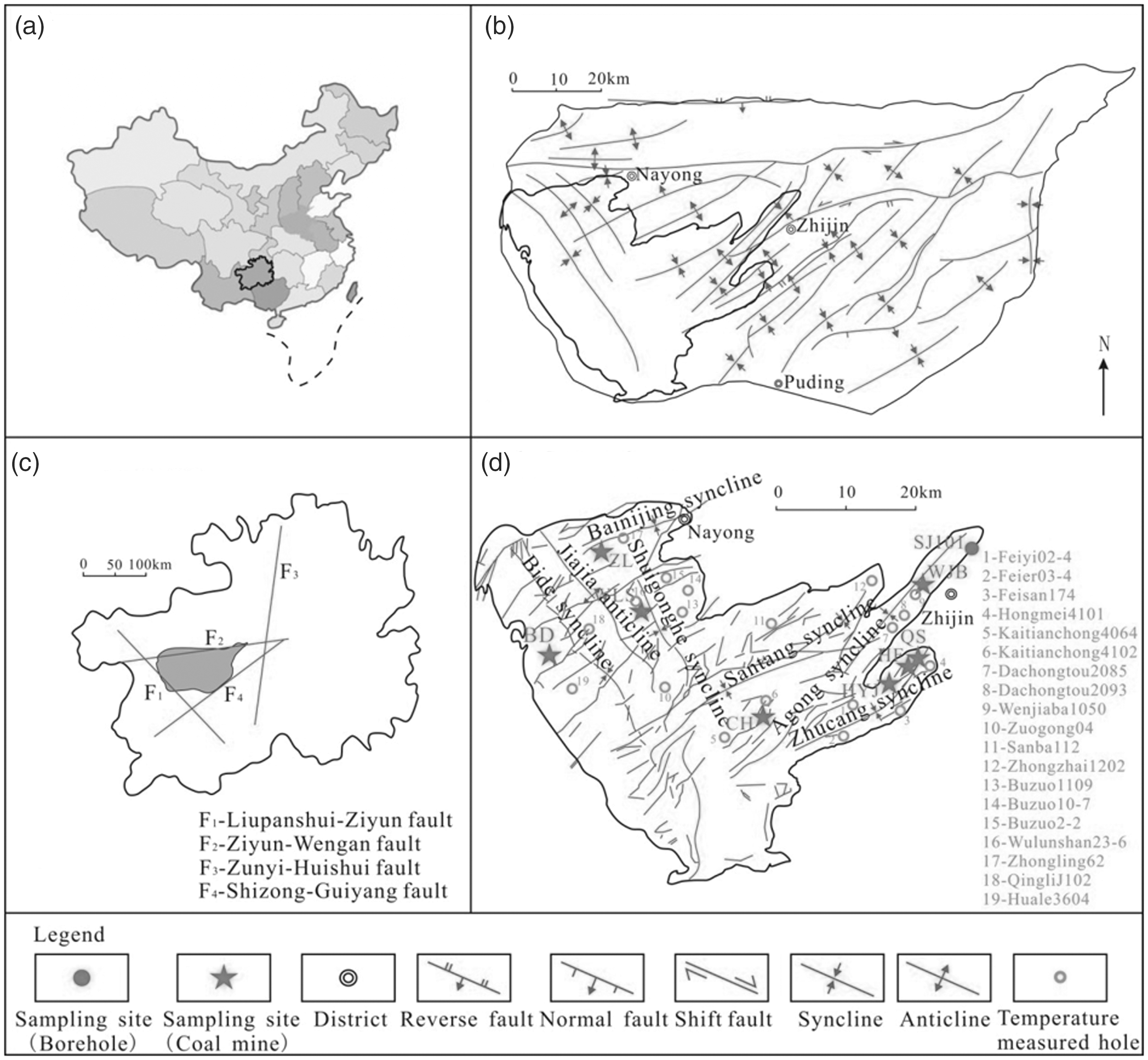
Structural map of the Zhina coalfield and the Bide-Santang basin with borehole sampling sites and temperature measurement locations. (a) China, (b) Zhina coalfield, (c) Guizhou province, and (d) Bide-Santang basin.
The Bide-Santang basin is located in the southwestern part of the Zhina coalfield and contains the majority of the coalfield, with a total area of 1692 km2 and a predicted coal-bearing area of 1000 km2 (Figure 1(d)). The Bide-Santang basin contains the Bide, Shuigonghe, Santang, Agong, and Zhucang coal-bearing synclines and numerous stacked coal seams. The structures in the region are predominantly NW- and NE-trending. The NE-trending structures (folds and faults) cut the NW-trending structures, demonstrating that the NW-trending structures formed before the NE-trending structures. The structures in the study area were mainly formed during the Yanshanian orogeny. During the early Yanshanian deformation, the maximum principal stress was E–W, producing a series of NW folds and faults at the western border near the fault zone. Subsequently, the principal stress changed orientation to SE–NW and NE-oriented folds and faults were formed in the middle and eastern part of the basin; thus, the basic tectonic framework of the Bide-Santang basin settled. During the late Yanshanian deformation, the early stage NE structures were sinistrally sheared into an ‘S’ shape. It has been shown that late-stage Yanshanian and Himalayan tectonics developed from the inherited early stage Yanshanian structures (Jin and Tang, 2010). The structures in the study area are characterized by open synclines and closed anticlines, and most of the anticlines were destroyed by faulting and seriously eroded. The coal and CBM resources mainly accumulated in the synclines.
The stratigraphic units in the study area include the Middle Permian Maokou Formation, the Upper Permian Emeishan Basalts, the Longtan Formation, and the Changxing Formation, the Lower Triassic Feixianguan Formation and the Yongningzhen Formation, and the Quaternary Systems. The Changxing and Longtan Formations contain stacked coal-bearing strata with a total thickness of 300–450 m. The study area contains 35 coal seams, of which 3–17 are minable. The composite thickness of all the coal seams is 24–41 m, with an average thickness of 33 m, and the total thickness of the minable seams is 9–23 m. The depositional environment of the coal-bearing strata was in a sea-land transition typical of the Late Permian. Sea-level fluctuations directly controlled the sequence stratigraphic framework and the spatial distribution of depositional systems that produced the coal-bearing strata (Xie and Cheng, 1992). Four sets of third-order sequences (SQ) were identified in the coal-bearing strata (Figure 2) (Shao et al., 2011).
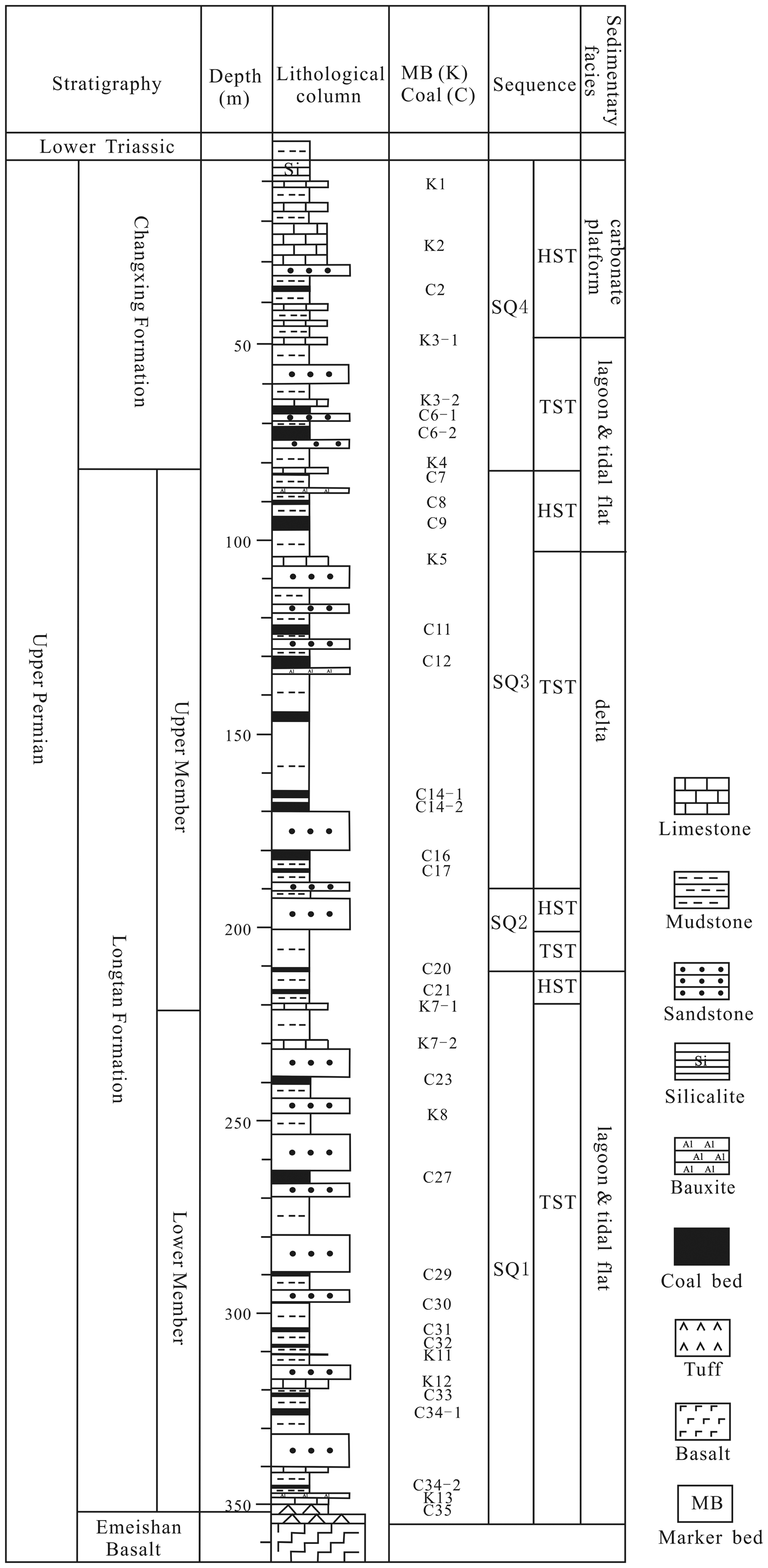
Stratigraphic column showing the lithology, depositional facies, and sequence stratigraphy of the Upper Permian coal series from the study area (modified from Guo et al. (2011)). HST: highstand system tract; SQ: sequence; TST: transgressive systems tract.
Based on the authors’ previous work on CBM geological conditions in the study area (Guo and Lu, 2016; Guo et al., 2014), the coal rank is dominated by anthracite with Ro, max between 1.92 and 3.14%, and meagre coal occurs along the western edge of the Bide-Santang basin. Maceral vitrinite ranges from 81.20 to 88.10%. The average gas content of the coal seams is 13.81 cm3 g−1; the gas content of the Wulunshan exploration area in the Shuigonghe syncline is the highest, reaching an average of 18.07 cm3g−1 (Xiong and Qin, 2007).
Samples and methods
Thermal conductivity is a key thermophysical property of rocks and a necessary parameter for calculating terrestrial heat flow (Luo et al., 2011; Peng et al., 2015a, 2015b; Sun et al., 2006). To fully understand the thermal conductivity of the Upper Permian coal-bearing strata in the Bide-Santang basin, 43 coal and rock samples were acquired and tested for their thermal conductivity, with sampling depths ranging from 120 to 500 m. The rock samples were taken from borehole SJ101, and the coal samples were obtained from surface coal from different coal mines in the Bide-Santang basin (Figure 1(d)). The sample lithologies include fine sandstone, siltstone, pelitic siltstone, silty mudstone, mudstone, limestone, and coal, covering most of the lithologies in the Upper Permian coal-bearing strata. The samples were tested at the Institute of Geomechanics, Chinese Academy of Geological Sciences. The apparatus utilized for the measurement was a Hot Disk thermal constants analyser, manufactured by Hot Disk Limited, Uppsala, Sweden, and the measurement was based on the Transient Plane Source (TPS) method (Figure 3). The TPS method was proposed by Gustafsson (1991) and has been developed to measure isotropic thermal conductivity and thermal diffusivity of solid, powder, porous material, and liquid. The TPS method can also be used to measure anisotropic thermal conductivity and specific heat capacity and became an ISO standard in 2015 (ISO, 2015).
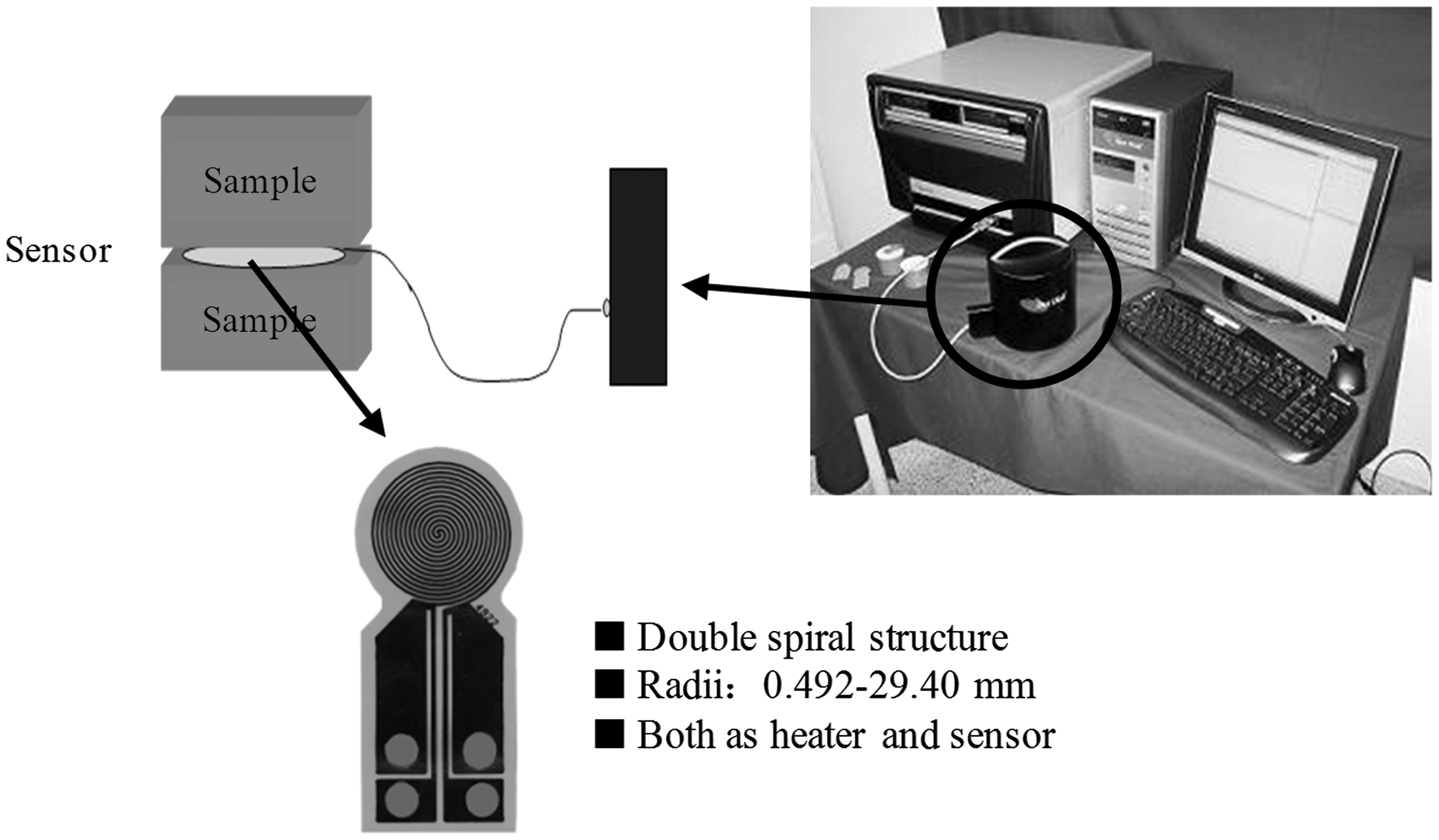
Thermal conductivity experimental apparatus and internal structure schematic.
Specifically, the TPS method can be used to measure the in-plane thermal conductivity and through-plane thermal conductivity of anisotropic materials if the main directions of the material are orthogonal and the thermal properties in the x–y plane are uniform. When performing the thermal conductivity measurement, a sensor (Figure 3) is placed between two pieces of anisotropic samples with smooth surfaces to form a sandwich structure. The heating sensor shown in Figure 3 has a double spiral shape of nickel and it is covered by two thin pieces of Kapton or mica insulation layers to maintain both electric insulation and a high structure mechanical strength. In the test, the sensor is used both as a heat source and as a temperature sensor. When the sensor is heated by a constant electric power, the temperature of the sensor will increase with time and it can be obtained from the variation of its electric resistance when the temperature coefficient of resistance of the heat element is known (Zhang et al., 2017).
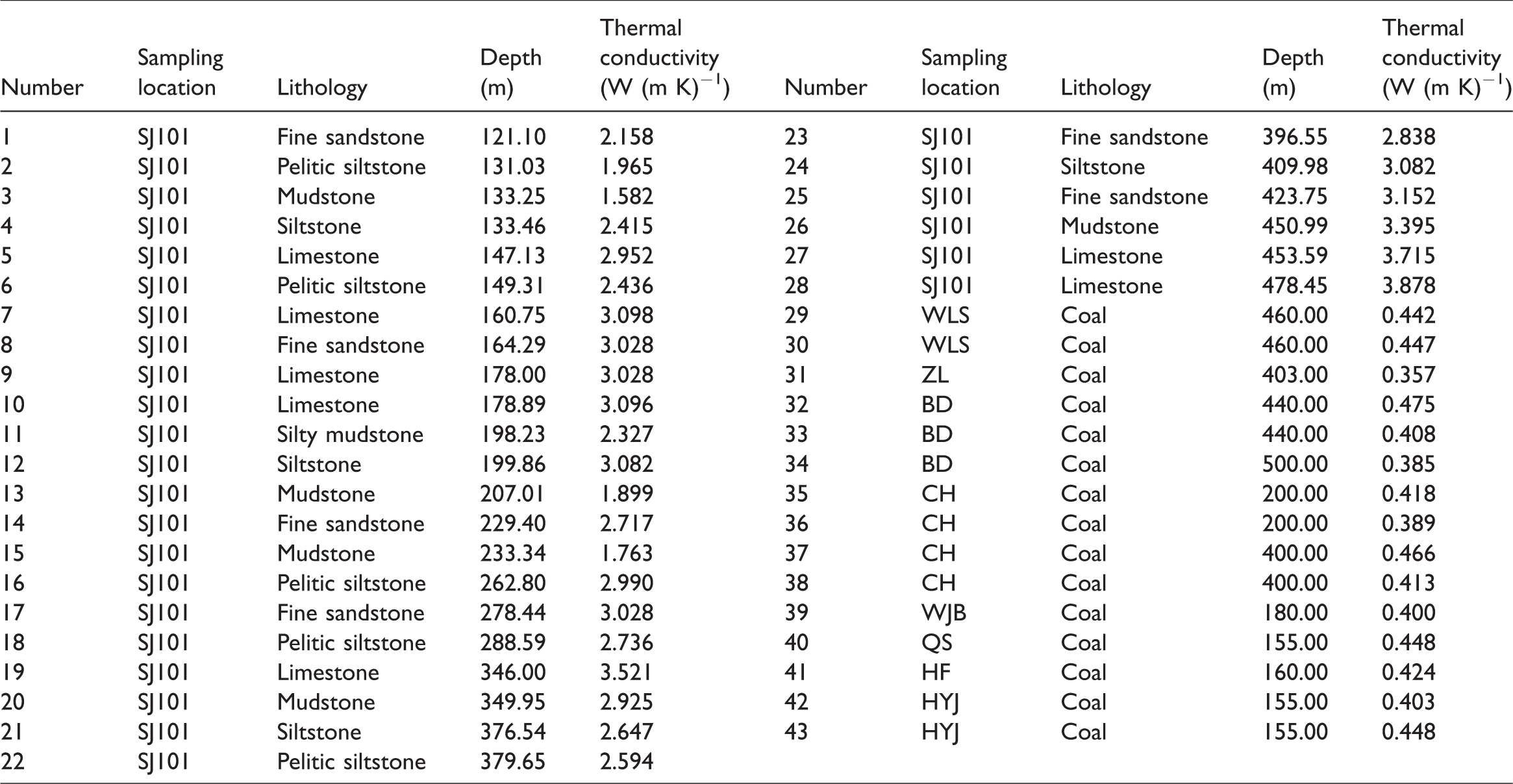
The thermal conductivity value was obtained from the average of three measurement values per sample at the maximum experimental temperature of 700°C; the analytical error is ±3% and the test range is 0.005–500 W (m K)−1. The thermal conductivity test results, combined with information involving depth, lithology, and location of the samples, are listed in Table 1.
Thermal conductivity testing results of rock samples from the Bide-Santang basin.
Results
The test results show that the thermal conductivity of the coal and rock samples from the coal-bearing strata in the Bide-Santang basin ranges from 0.357 to 3.878 W (m K)−1 and averages 1.962 W (m K)−1 (Table 1). The thermal conductivity of the coal samples is significantly lower than that of the rock samples, ranging from 0.357 to 0.475 W (m K)−1 and averaging 0.422 W (m K)−1. The thermal conductivity of the rock samples ranges from 1.582 to 3.878 W (m K)−1 and averages 2.787 W (m K)−1, with values mainly between 2.5 and 3.5 W (m K)−1 (Figure 4). The coal rank in the study area is predominantly anthracite, which may be the reason for the similar thermal conductivities for coal samples. The burial depth and lithology are the key factors controlling rock thermal conductivity in the study area, which will be analysed in the following.
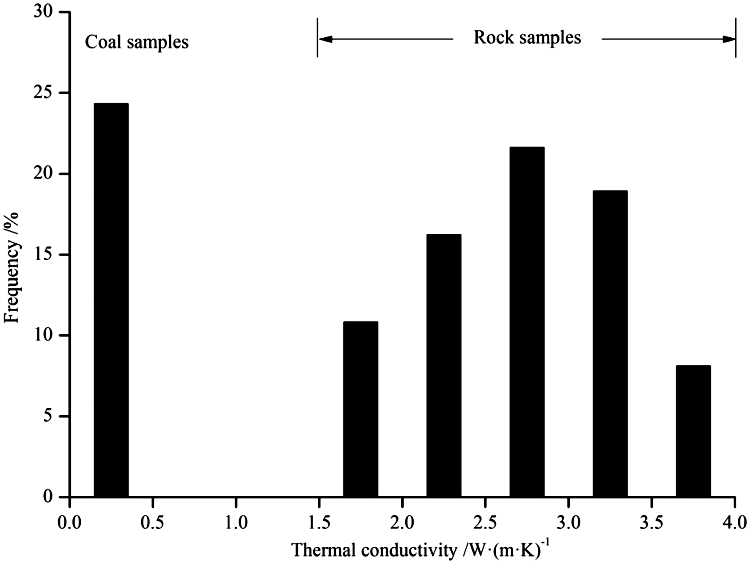
Histogram of thermal conductivity for the coal series in the Bide-Santang basin.
To better reflect the general trend and avoid skewing due to the sample shortages for some lithologies, the silty mudstone was regarded as mudstone, and the pelitic siltstone was regarded as siltstone. For the same lithology, the thermal conductivity of samples increases significantly with increasing depth (Figure 5), with the best correlations observed for limestone and mudstone (Figure 5(b) and (c)). The slope of the fitted equation between depth and thermal conductivity for mudstone samples is higher than those for other lithologies (Figure 5(c)), indicating that mudstone is more sensitive to the depth and the resulting effect of compaction. In general, thermal conductivity is positively correlated with burial depth.
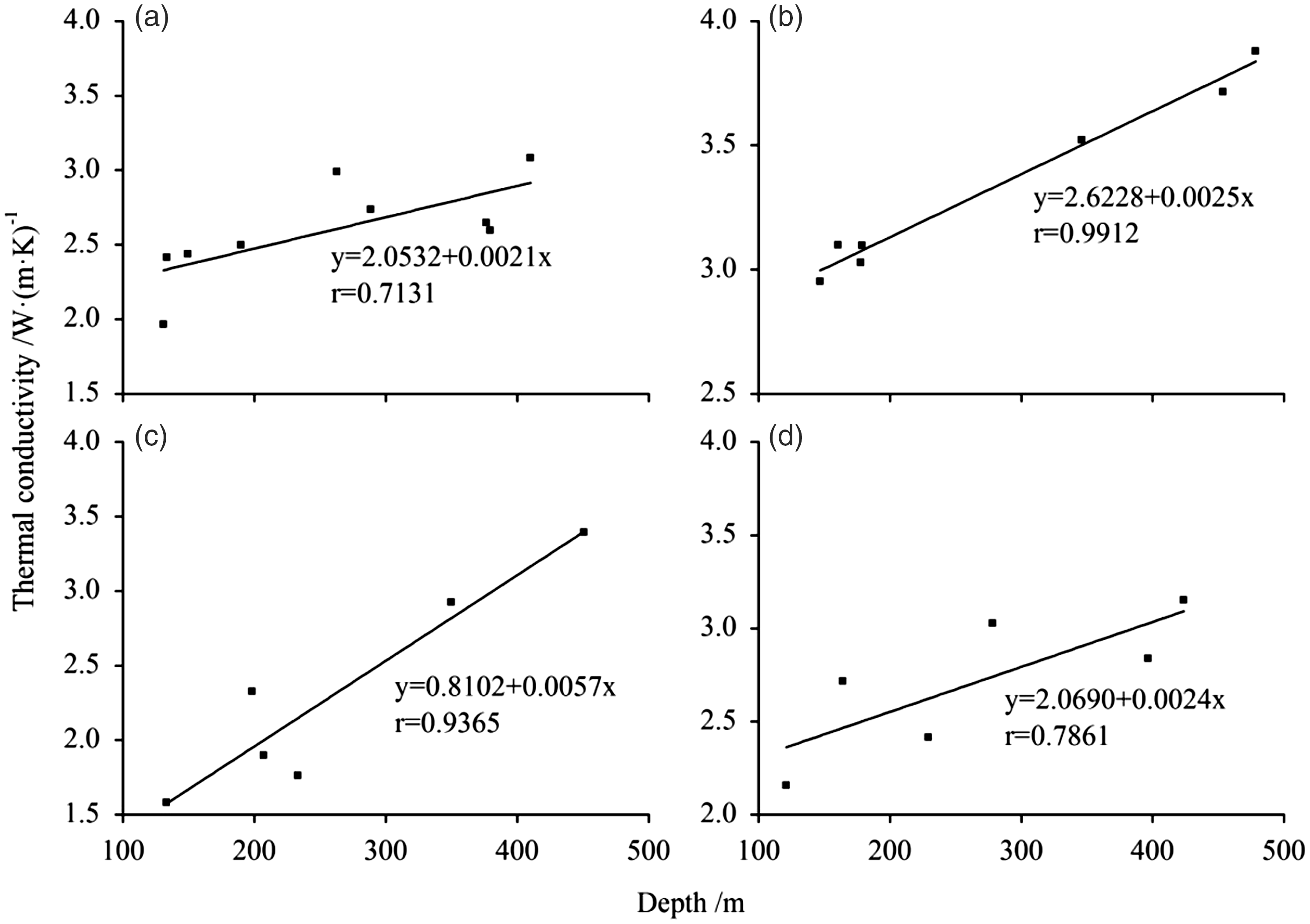
Relationship between thermal conductivity and depth for different lithologies. (a) Siltstone, (b) limestone, (c) mudstone, and (d) fine sandstone.
The thermal conductivity for different lithologic samples varies significantly. As noted above, the coal samples have the lowest thermal conductivities. Figure 8 further reveals that thermal conductivity increases based on lithology in the following order: coal, mudstone, siltstone, fine sandstone, and limestone, with average thermal conductivities of 0.422, 2.315, 2.661, 2.820, and 3.327 W (m K)−1, respectively. Correspondingly, the rock density also increases in the same lithologic order, with the density of coal ranging from 1.2 to 1.7 g cm−3, mudstone ranging from 2.0 to 2.5 g cm−3, fine sandstone ranging from 2.1 to 2.7 g cm−3, and limestone ranging from 2.3 to 2.9 g cm−3 (Li and Yang, 1994). These data show the positive relationship between thermal conductivity and rock density. Thermal conductivity is controlled by lithology, especially those different genetic lithologies with obvious density and component differences (Figure 6).
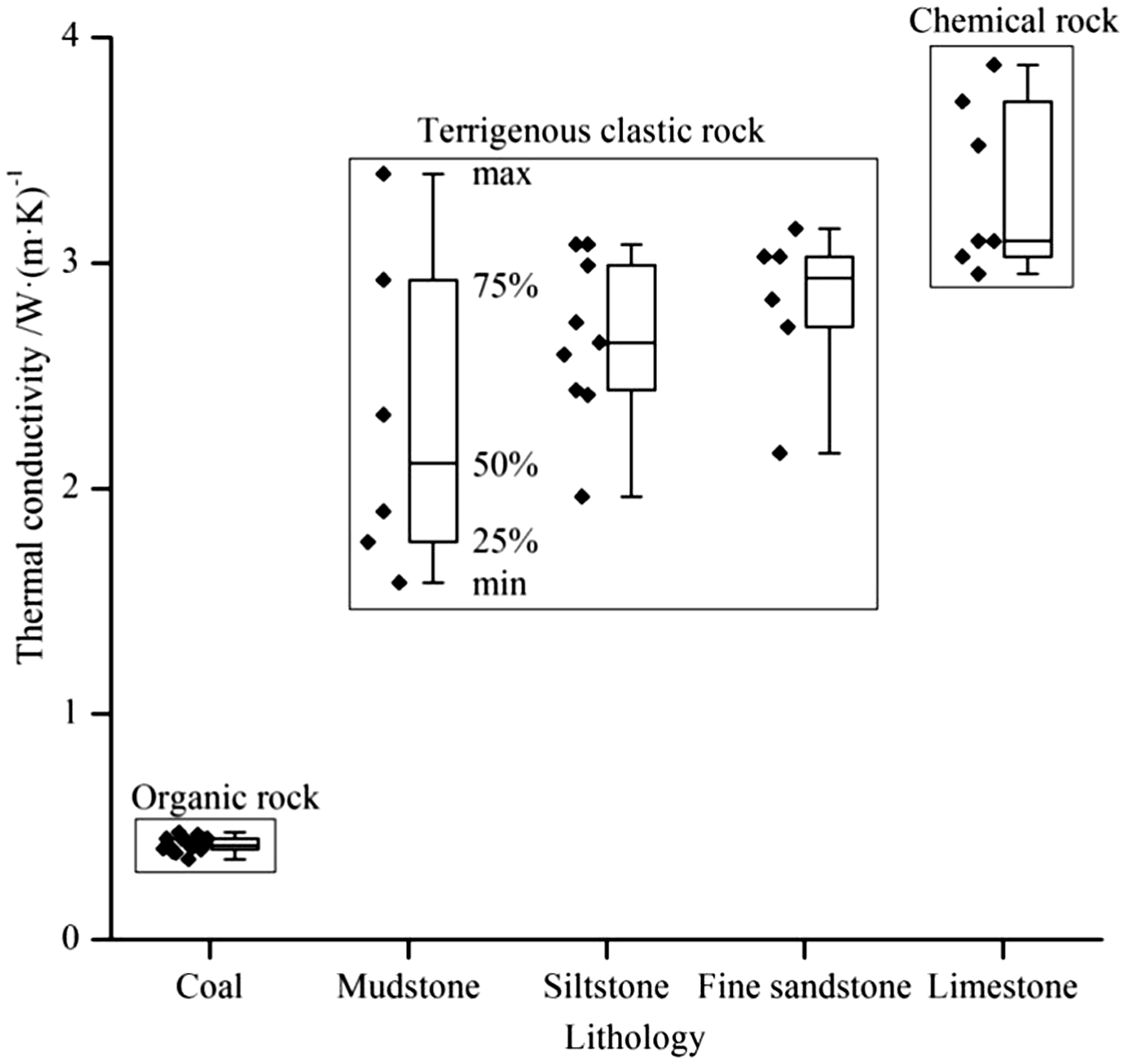
Box chart of thermal conductivity for different lithologies.
Discussion
Present geothermal field characteristics
For the present-day coalfield geological prospecting in China, there are two kinds of geothermal measurement methods, one is called simple temperature measurement and the other is called approximate steady-state temperature measurement. The latter is more accurate and can be used to calculate the geothermal gradient and terrestrial heat flow (Tan et al., 2009). However, many drilling operations in coalfield prospecting have used the simple temperature measuring method, and those results need to be corrected in order to calculate the heat flow and geothermal gradient. The commonly used correction method is called a ‘three-point method’, which is realized by interpolating between the temperatures of the bottom of the borehole, the neutral point, and the constant temperature zone, to construct the corrected approximate steady-state temperature curve.
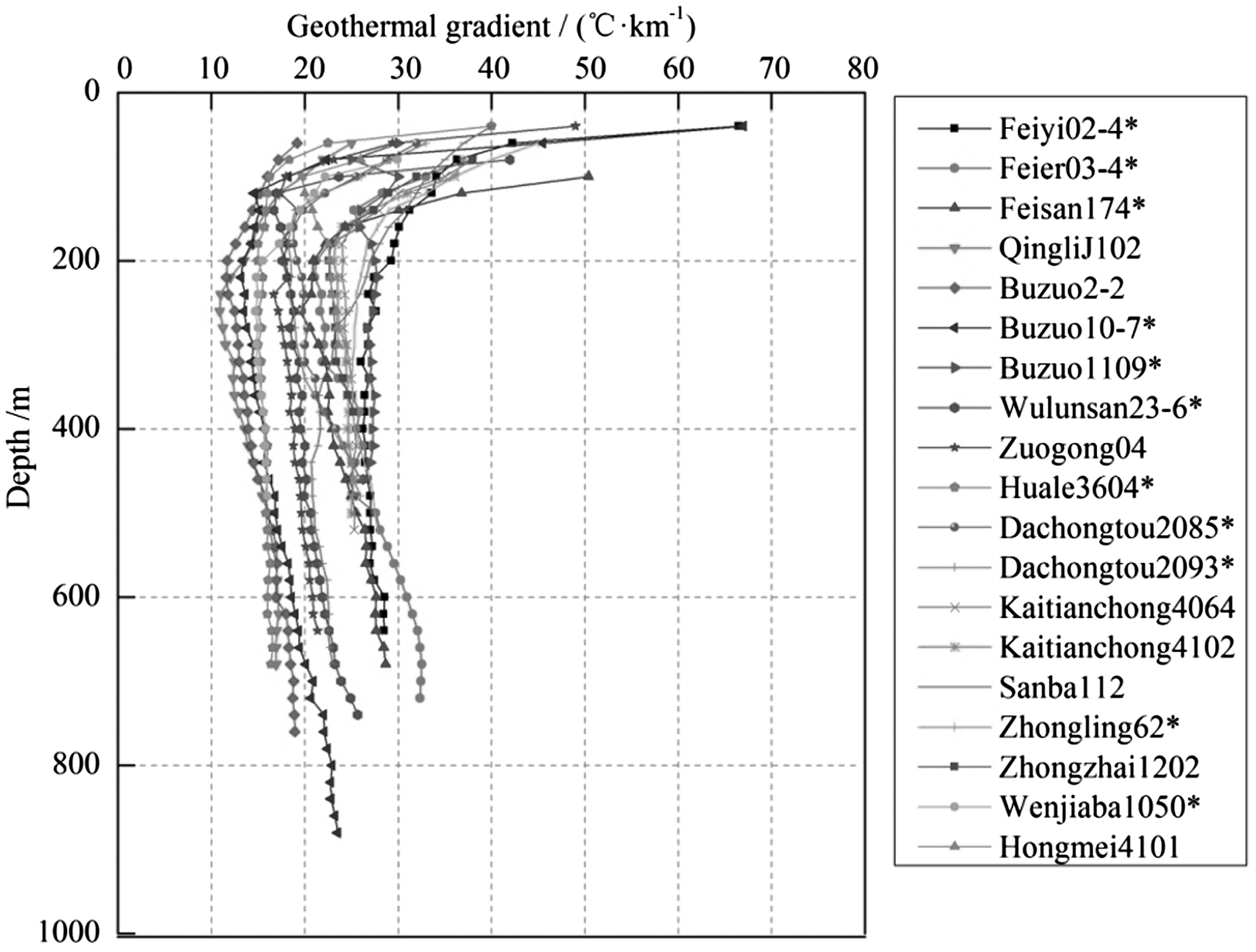
Figure 7 shows the temperature curves from 11 approximate steady-state temperature measurement boreholes and eight corrected simple temperature measurement boreholes, indicating that the geotemperature increases with depth in an approximately linear manner, presenting typical heat conduction warming characteristics.
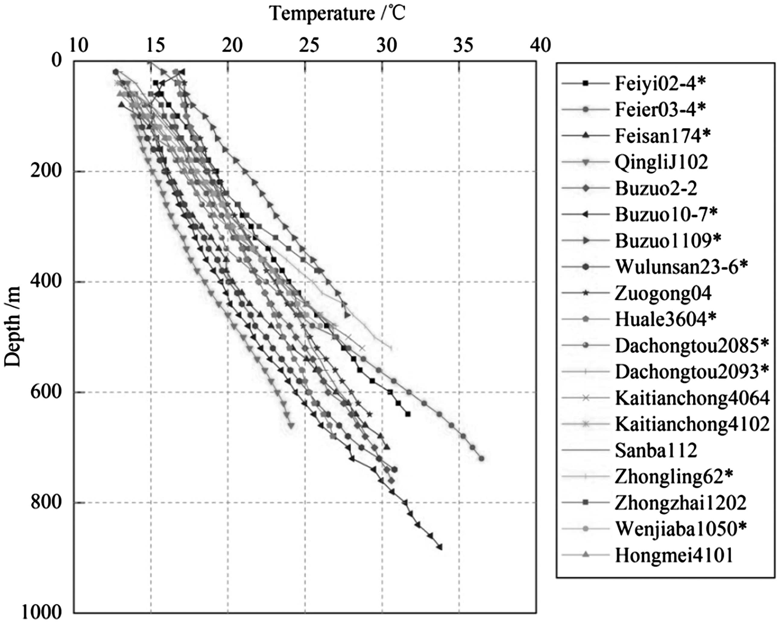
Temperature-logging curves of boreholes in the Bide-Santang basin. *Represents the approximate steady-state temperature measurement borehole, similarly hereinafter.
The rate of temperature increase with depth in the subsurface is called the geothermal gradient (Abdula, 2016). The depth and temperature of the constant temperature surface of temperature measured holes were analysed and counted, and the average geothermal gradient of the hole was calculated by the following equation

In addition to the average geothermal gradient, the geothermal gradient of each temperature measurement point in the boreholes was also calculated, in order to reveal the vertical variation of geothermal gradient in a given borehole (Figure 8). The average geothermal gradient of exploration areas and synclines was acquired from the data of boreholes within these regions (Table 2).
Relationship between present geothermal gradient and depth of temperature-logging holes in the Bide-Santang basin.
Present geothermal gradient distribution in the Bide-Santang basin (°C km−1).
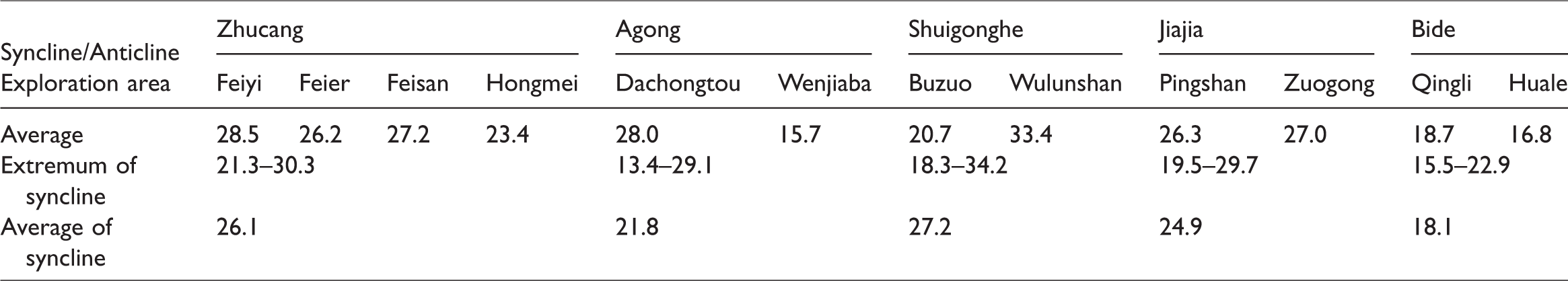
The calculation results showed that (1) the average geothermal gradient of the boreholes ranges from 15.5 to 30.3°C km−1 and averages 23.5°C km−1; (2) vertically, the geothermal gradient decreases dramatically with the increase of depth above 200 m, then increases gently and tends to remain stable with depth; and (3) regionally, the Wulunshan exploration area in the Shuigonghe syncline has the highest geothermal gradient, followed by the Feiyi exploration area in the Zhucang syncline, and the geothermal gradient of the Bide syncline is relatively low (Figure 8 and Table 2).
Distribution of terrestrial heat flow
Terrestrial heat flow is a key parameter for the characterization of the earth’s internal thermal state, the analysis of lithospheric thermal structure and geodynamics, and the evaluation of regional geothermal resources (Cui et al., 2007; Jiang et al., 2016; Kovacic, 2014; Majorowicz et al., 2014; Mohamed et al., 2016; Qiu et al., 2004). Heat flow is the product of rock heat conductivity and geothermal gradient

Terrestrial heat flow data for the temperature-logging boreholes in the Bide-Santang basin.
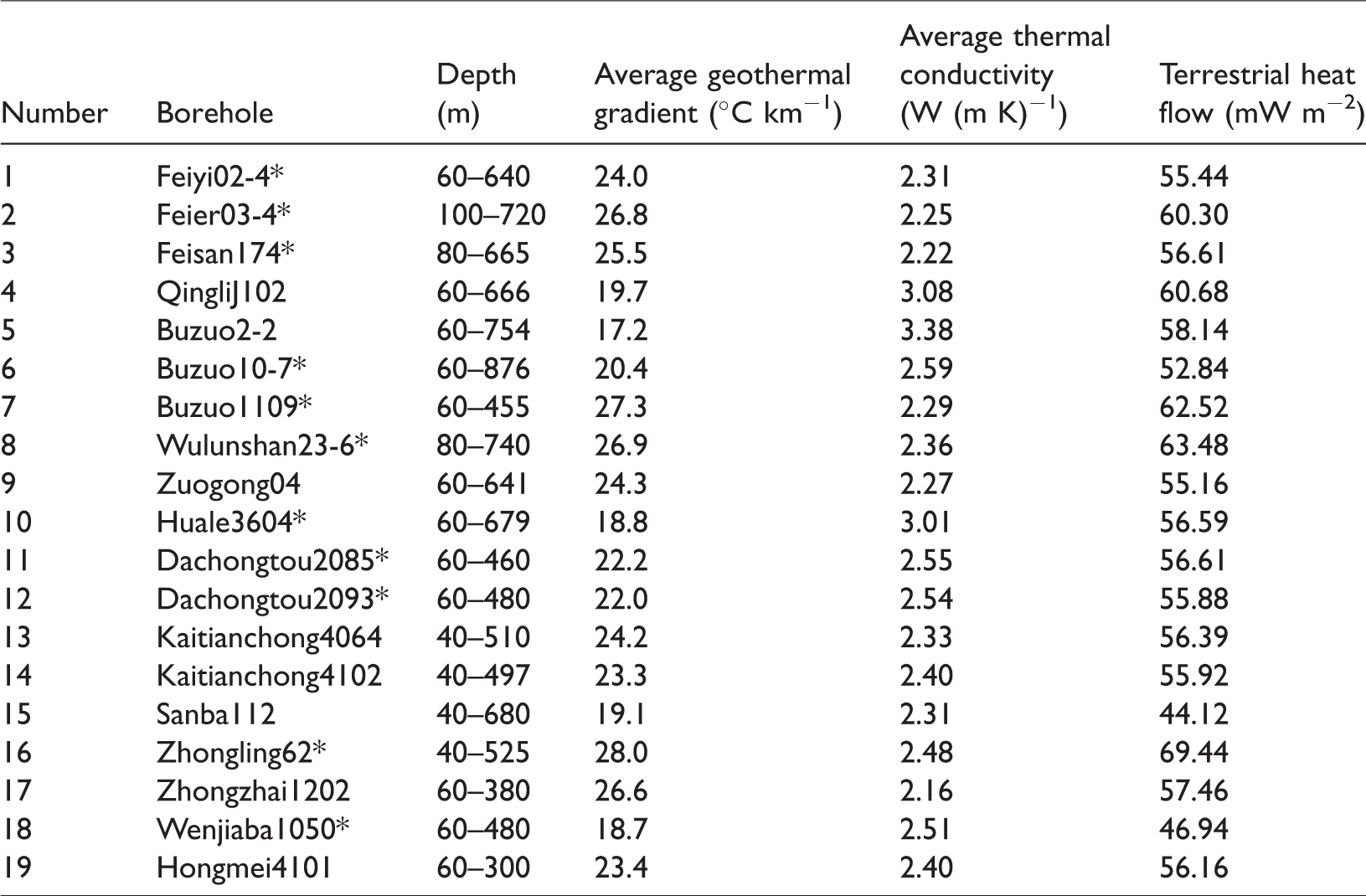
The terrestrial heat flow data for 11 approximately steady-state temperature measurement holes and eight simple temperature measurement holes were calculated with depth ranges from 40 to 876 m. The results show that terrestrial heat flow ranges from 46.94 to 69.44 mW m−2, averaging 57.55 mW m−2, and the most frequently occurring values are in the interval 55–60 mW m−2 (Table 3 and Figure 9). The average terrestrial heat flow in South China is 64.2 mW m−2, and the average geothermal gradient is 24.1°C km−1, so it is clear that the heat flow and geothermal gradient in the study is lower than that in South China as a whole (Yuan et al., 2006).
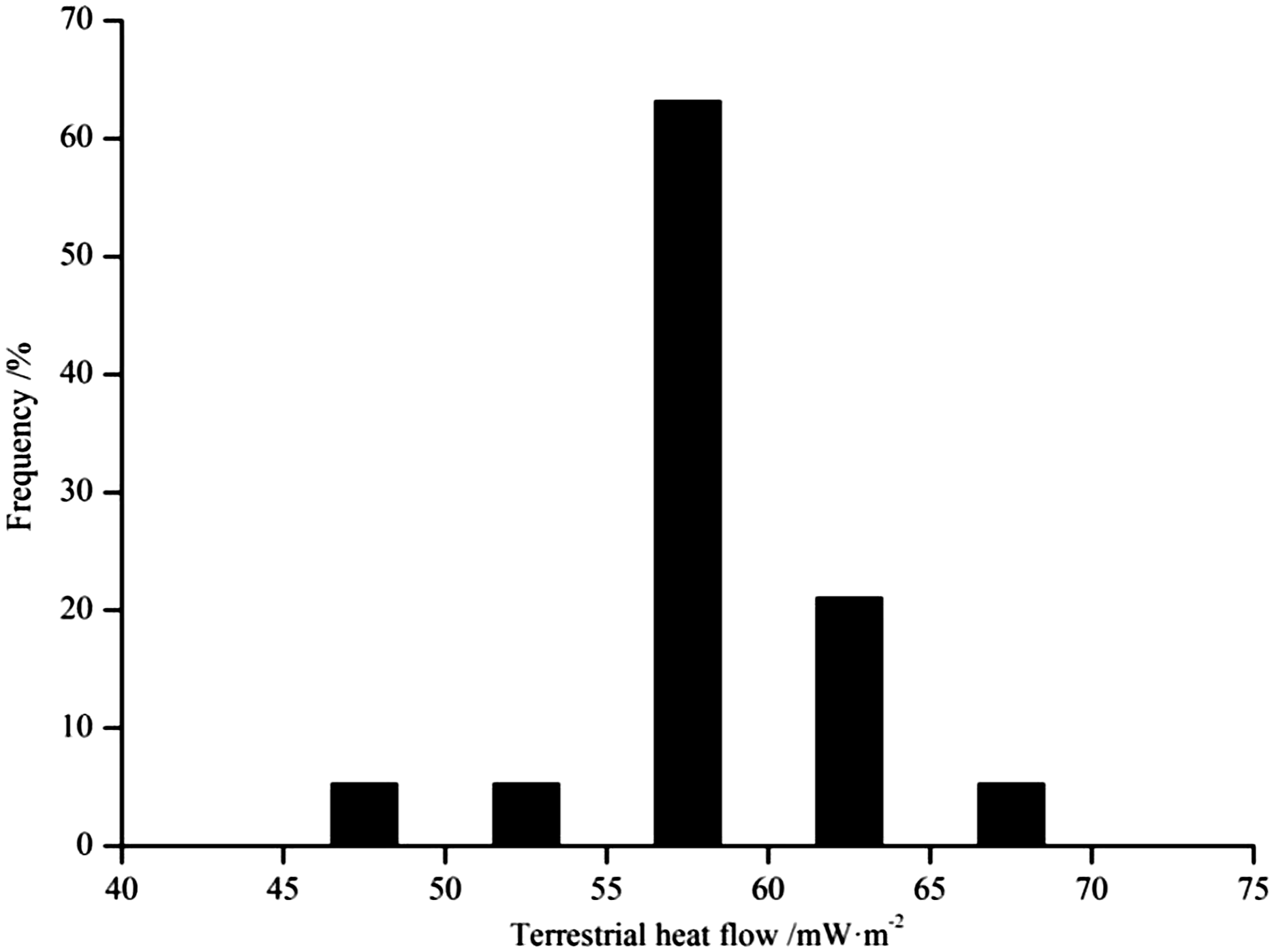
Histogram of the terrestrial heat flow data for the Bide-Santang basin.
The contour map of terrestrial heat flow in the study area is based on the heat flow data in Table 3. The heat flow distribution is consistent with the main structural orientation, indicating that heat flow is controlled by the regional tectonic framework (Figure 10). The heat flow value is higher in the Jiajia anticline, the Shuigonghe syncline, and the Zhucang syncline. Specifically, the heat flow of the Wulunshan exploration area in the Shuigonghe syncline reaches 63.48 mW m−2, while the heat flow of the Feier exploration area in the Zhucang syncline reaches 60.30 mW m−2. In contrast, the heat flow is lower in the Santang syncline, and heat flow in the Sanba exploration area in this syncline is only 44.12 mW m−2. The distribution of the geothermal gradient generally corresponds to that of the terrestrial heat flow (Figure 11). The western limb of the Bide syncline at the western margin of the Bide-Santang basin has a relatively low geothermal gradient and heat flow.
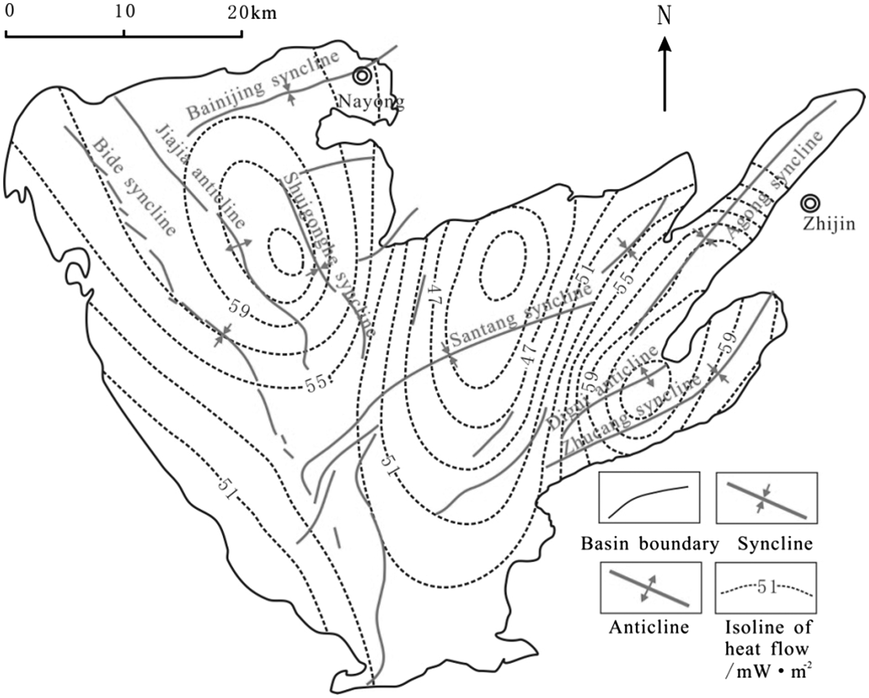
Contour map of terrestrial heat flow in the Bide-Santang basin.
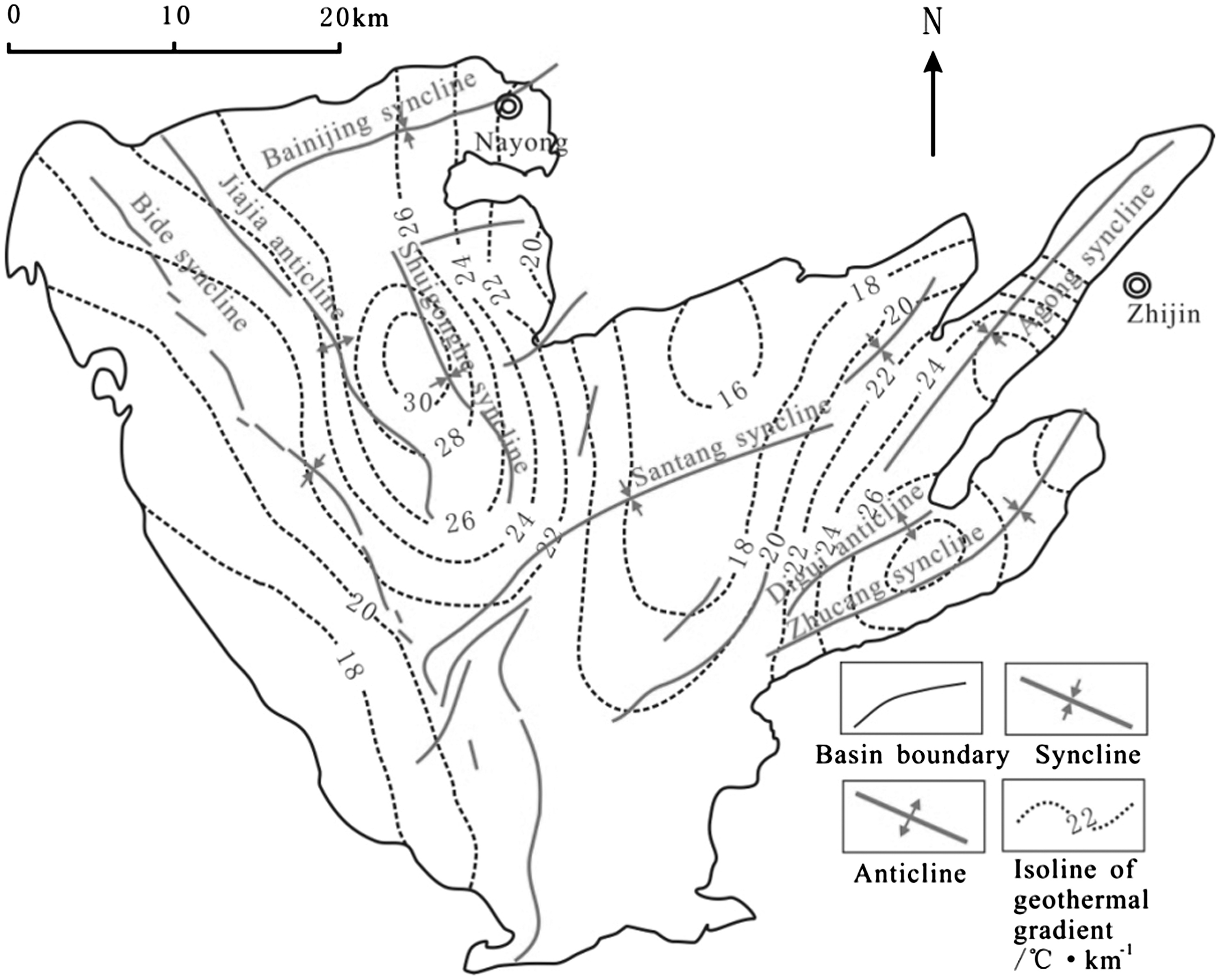
Contour map of the present geothermal gradient in the Bide-Santang basin.
Factors controlling the present-day geothermal gradient and heat flow
The factors controlling the present-day geothermal gradient and heat flow in the study area are discussed in this section from the perspective of tectonics, burial depth, thermal conductivity, and groundwater (Giordano et al., 2016; Sandiford et al., 1998).
Folding and faulting
Folding causes the geothermal gradient to change regularly in the direction of the rock stratum’s inclination: anticlines accumulate heat, whereas synclines dissipate heat (Liu, 1982). Along the anticlinal axis, the thermal conductivity in the vertical direction relative to the bedding plane is lower than that parallel to the bedding plane, which results in heat flow accumulation within the anticlinal axis, and relatively low heat flow in the limbs. Heat flow is generally low in the Bide-Santang basin, which may be ascribed to its tectonic characteristics of open synclines and closed anticlines since the coal-bearing strata occur mainly in the synclines. The low heat flow also indicates that tectonic movement in the study area is relatively stable. There are areas of relatively high heat flow: the Jiajia anticline has higher heat flow and geothermal gradient, and the Digui anticline between the Zhucang syncline and the Agong syncline also shows higher heat flow. Conversely, as the broadest synclines in the study area, the Bide syncline and the Santang syncline show lower heat flows and geothermal gradients. Moreover, the coal-bearing strata in the northern part of the Santang syncline have been seriously eroded (Tang, 2013), which further dissipates the heat flow and lowers the geothermal gradient.
Faulting provides a channel for the conduction of heat flow and allows deep geothermal water to transfer heat to the upper crust, increasing the geotemperature and geothermal gradient in the shallow crust (Uzelli et al., 2017). There are more than 71 hot springs in Guizhou Province, which reflects the thermal conduction that results from modern active faults (Chen et al., 2012). High angle normal faults are well developed in Palaeogene and older strata in the Shuigonghe syncline, and deep geothermal water is transmitted to the upper crust along these faults. Heat is concentrated in upper Palaeogene strata due to its unconsolidated overburden, and the heat is transmitted laterally to the surrounding strata, leading to the high heat flow and geothermal gradient observed in the Shuigonghe syncline.
Burial depth and thermal conductivity
In addition to tectonics and geothermal background, thermal conductivity in shallow crustal rocks also exerts an important influence on the geothermal gradient and heat flow in the study area (Tan et al., 2010). As noted above, thermal conductivity increases with depth, so for a stable heat flow value, the geothermal gradient will decrease up-section. Generally, strata with low thermal conductivity have a high geothermal gradient, whereas strata with high thermal conductivity have a low geothermal gradient. The high geothermal gradient in the shallow strata may be due to the low thermal conductivity of the unconsolidated sedimentary cover, which blocks the spread and dissipation of the heat flow. The sedimentary cover in the north of the Buzuo exploration area in the Shuigonghe syncline is thicker than that in the south, and correspondingly, the geothermal gradient in the north is higher (Lu et al., 2013).
Groundwater
Temperature differences between groundwater and the surrounding rocks will cause a change in the geotemperature (Correia et al., 2017; Danis, 2014). At the margins of a basin, the groundwater is recharged and flows to the deeper parts of the basin, where the water is warmed and the surrounding rocks are cooled, resulting in a reduced geotemperature at the margin. In the centre of a basin, the temperature of the groundwater and the surrounding rock is similar as a result of increased water–rock interaction, so the geotemperature is higher in the centre than at the margin of a basin. As a syndepositional fault, the Liupanshui-Ziyun fault at the western margin of the Bide-Santang basin serves as a conduit for groundwater recharge from precipitation, reducing the heat flow and geotemperature along the fault. The hydrochemical index constructed by the author (Guo, 2015) is defined as follows:

Some boreholes, such as boreholes No. 10-6 and 8-1 in the Buzuo exploration area, have abnormal temperature-logging curves in that the temperature decreases with depth initially and then increases. A pump test in hole No. 23-4, near these two temperature holes, shows higher unit water inflow values and permeability coefficients. The unit water inflow value is 0.1062 l s−1 m−1, and the permeability coefficient is 0.8158 m d−1, reflecting a stronger hydrodynamic condition in this area, which will lower the geotemperature, especially for shallow groundwater. With increasing depth, the hydrodynamic condition weakens and the geotemperature increases (Figure 12).
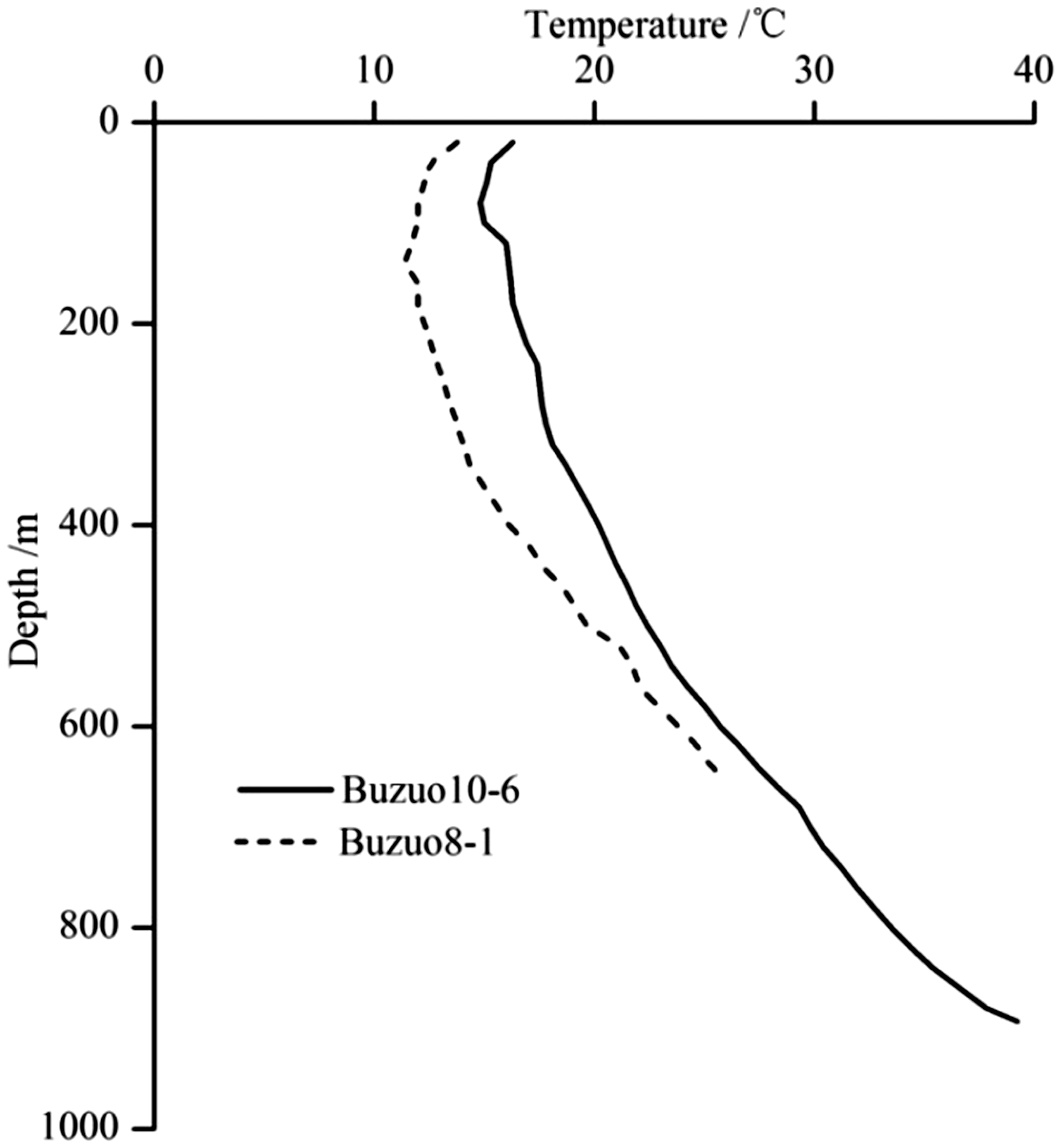
Relationship between borehole depth and formation temperature in the Buzuo area.
The relationship between heat flow and gas content
The No. 6 coal seam is used as a case study of the relationship between terrestrial heat flow and gas content in the study area. Figure 13 shows that there is a correlation between the two. The area of high heat flow coincides with the area of high gas content in the Wulunshan exploration area, which is located in the western limb of the Shuigonghe syncline. The heat flow and gas content at the western margin of the Bide-Santang basin are relatively lower. Additionally, the gas content in the north of the Santang syncline with low heat flow is lower than 20 m3 t−1, while the gas content of the Zhucang syncline with higher heat flow is higher than 20 m3 t−1. The reasons for the positive relationship between the heat flow and gas content may lie in the following. (1) The observed heat flow is inherited from the palaeogeothermal background during the period when CBM was generated in large quantities (Sun et al., 2006) due to intense magmatic activity. Since the Triassic, Guizhou Province has experienced the Indosinian, Yanshanian, and Himalayan tectonic events, among which the Yanshanian produced the most magmatic activity. The widespread high-grade metamorphic anthracite in the study area resulted from the superposition of the Yanshanian magmatic thermal metamorphism on the regional metamorphism. The coal experienced a secondary hydrocarbon generation process during the Yanshanian, and as a result, the gas content in coal seams was increased significantly (Qin et al., 2012a; Tang, 2012). Present-day heat flow has inherited the abnormally high palaeogeothermal background of the Yanshanian period. (2) High heat flow areas are always located far away from areas of groundwater recharge, and the weak hydrodynamic conditions benefit CBM accumulation.
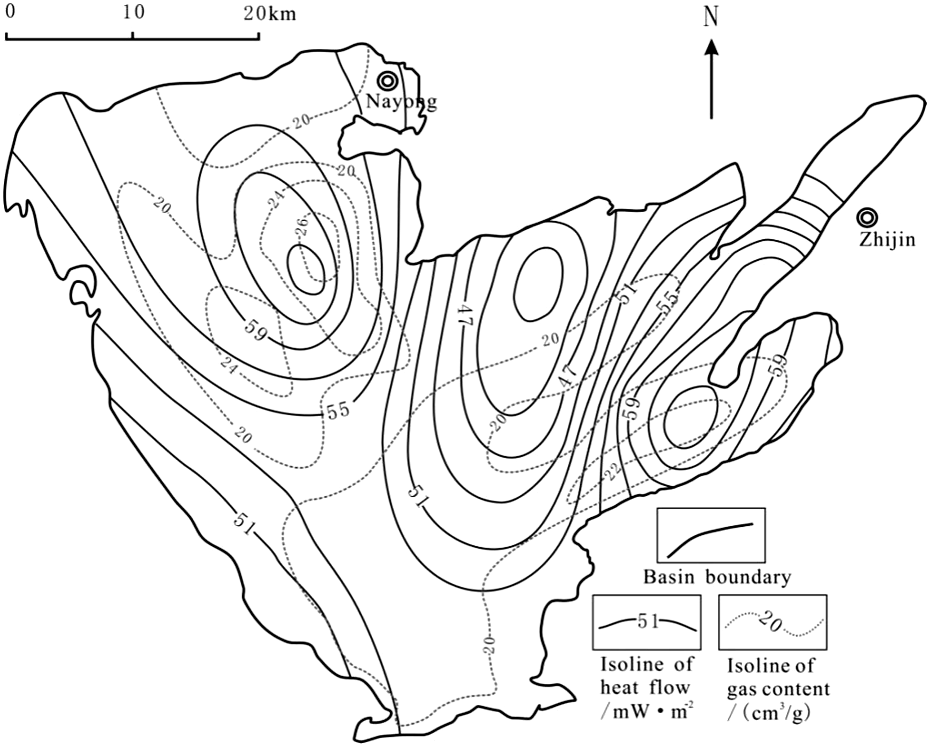
Relationship between terrestrial heat flow and gas content in the No. 6 coal seam.
Conclusions
Thermal conductivity is controlled by lithology and burial depth and increases in the lithologic order of coal/mudstone/siltstone/fine sandstone/limestone. For the same lithology, the thermal conductivity increases with increasing burial depth. The present-day geothermal gradient and terrestrial heat flow of the Bide-Santang basin are generally lower than the average levels for South China, reflecting relatively stable present-day tectonics in the study area. The Shuigonghe syncline, the Jiajia anticline, and the Zhucang syncline show a higher heat flow and geothermal gradient, where the deep coal mining operations should incorporate more attention to the risk of thermal damage and gas outburst. The gas content of the coal seam positively correlates to terrestrial heat flow, indicating that the present heat flow is inherited from the abnormally high palaeogeothermal background during Yanshanian deformation when CBM was generated in large quantity due to intense magmatic activity. The area with high gas content and high heat flow would be a priority for CBM development.
Footnotes
Acknowledgements
The authors thank the reviews for providing their constructive remarks and comments. We thank all parties that contributed to this publication.
Declaration of conflicting interests
The author(s) declared no potential conflicts of interest with respect to the research, authorship, and/or publication of this article.
Funding
The author(s) disclosed receipt of the following financial support for the research, authorship, and/or publication of this article: This paper is jointly sponsored by the Key Projects of Natural Science Foundation of China (40730422), the National Science and Technology Major Special Project of China (2016ZX05044), the Doctoral Scientific Research Launch Foundation of Xi’an University of Science and Technology (2016QDJ028), and the Scientific Research Cultivating Fund of Xi’an University of Science and Technology (201718).