
Abstract
Five boreholes were selected in the Gujiao block, Xishan, Taiyuan, China, as calibration wells to identify the coal structure. The geophysical-log responses of the coal structure in the No. 8 coal reservoir, Gujiao block, were investigated using coal-core logging combined with actual observations in the borehole profile of the coal mine. Natural gamma, density, apparent resistivity, and sonic travel time logs were extracted at 0.15 m intervals from 41 undeformed coal, 29 cataclastic coal, and 48 granulated coal regions. Box plots and Fisher’s maximum separation criterion were used to screen and identify sensitive log responses of the coal structure. The coal structure was identified in 31 boreholes using the available logs in the block, and the layered distribution patterns of the coal structure were discussed. The fracturability of the coal structure was divided into types using cluster analysis based on the thickness ratio of the coal structure and the relationship between the coal structure and its permeability. The results show that sensitive log responses for identifying undeformed coal and cataclastic coal are natural gamma, followed by density and apparent resistivity; log responses for identifying cataclastic coal and granulated coal-mylonitized coal are sonic travel time, apparent resistivity and natural gamma. The sensitive log response data were integrated and coal structure identification models were constructed based on the principle of amplifying the log responses to identify the coal structure in the No. 8 coal reservoir. The reservoir generally contains two or three dirt bands, and the coal structure is divided into several independent layers, with the cataclastic coal and granulated coal-mylonitized coal distributed in the middle of the reservoir. The coal structure was classified into four types and four subtypes through cluster analysis of the boreholes. Under the control of the Malan syncline, type I and type II are developed in the No. 8 coal reservoir in the southern part of the study area and in the east and north wings of the Malan syncline; they have good fracturability. Type III and type IV are mainly present in the No. 8 coal reservoir at the synclinal axis; they have poor fracturability. For type IV dominated by granulated coal, it is difficult to improve the reservoir permeability by fracturing; therefore, other strengthened permeability-improving measures should be considered.
Introduction
The Gujiao block in the Xishan coalfield, Shanxi Province, China, has rich coal-bed methane (CBM) resources (Mo et al., 2008) and is one of the blocks constructed in recent years for the large-scale development of CBM in China. After the formation of the coal-bearing strata, the Gujiao block has experienced Hercynian, Yanshanian, and Himalayan tectonic movements, causing varying degrees of tectonic destruction in the coal reservoirs. The high heterogeneity of the coal structure results in considerable variations in the permeability of the main coal reservoir (Li, 2001; Li et al., 2012; Meng et al., 2011; Pan et al., 2012; Wang et al., 2013). On the one hand, the variations severely affect the well production of CBM (Pan et al., 2012; Xu et al., 2015); on the other hand, they make it difficult to determine a favorable production region and well location. Scientific prediction of the coal structure in the main coal reservoir is the primary technical issue that guides CBM exploration and development in this region.
Coal structure can be identified using various methods such as geological analysis, rock mechanics, and logging. Differences in the physical and chemical properties of coal result in a good correlation between coal structure and log responses (Fu et al., 2009a; Peng et al., 2008; Teng et al., 2013, 2015; Yao et al., 2011). As the level of either structural destruction or deteriorated coal structure increases, the apparent resistivity, sonic travel time, and caliper log responses are enhanced and the natural gamma and density log responses are attenuated (Teng et al., 2015; Yegireddi and Bhaskar, 2009; Zhou and Yao, 2014). Thus, geophysical logging is the most cost-effective method to have high reliability (Chen et al., 2013; Li et al., 2016; Gan et al., 2016).
Coal core cataloguing and underground coal wall observation corresponding to one or multiple log responses allows for qualitative and quantitative identification of the coal structure in boreholes. For instance, caliper log changes in the X and Y directions combined with resistivity and natural gamma changes were used for the qualitative evaluation of coal structure by Chen et al. (2013). Based on the relationship between resistivity and rock structural characteristics, the Archie formula was used both to calculate the pore structure index of tectonically deformed coal and to quantitatively identify the coal structure (Yao et al., 2011). Log responses were combined to quantitatively identify the coal structure based on the principle of amplifying the log response (Xie and Fan, 2013). Neural networks and support vector machines were also used to predict coal structure (Ghosh et al., 2016; Guo, 2015; Rolon et al., 2009). However, there are differences in the physico-chemical properties and log responses of the coal structure in different regions; thus, there is a need to screen the sensitivity parameters and their combinations for log responses of coal structure (Hatherly, 2013; Teng et al., 2015).
Currently, hydraulic fracturing is the most economically feasible method to increase the fracture connectivity and permeability of coal reservoirs (Pant et al., 2015). Moderate stress damage can increase the fractures and permeability of coal reservoirs. However, sustained high stress can destruct coal into granules, changing the cleat system of coal and significantly reducing the permeability of the coal reservoir (Meng and Li, 2013; Meng et al., 2016). Thus, hydraulic fracturing actually decreases the permeability of granulated-mylonitized coal (Guo et al., 2014).
In this study, we analyzed the coal structure in 31 boreholes of the No. 8 coal reservoir using the log responses of the coal structure in five calibration wells and model validation in another well. Furthermore, we predicted the fracturability of this coal reservoir and its regional distribution.
Geological setting
The Xishan coalfield is located in the middle section of the Shanxi fault on the Sino-Korean paraplatform. This coalfield is adjacent to the Taiyuan basin and the Qinshui depression in the southeast and close to the Yuxian-Yangqu east–west-striking fault-fold belt in the north. The coalfield is bounded by the Ximing, Jinci, and Qingduan faults (north to south) in the east and by the Lvliang uplift in the west (Figure 1). The Gujiao block is situated in the Northwestern Xishan coalfield and covers the well fields of Dongqu, Xiqu, Tunlan, and Malan (Wang et al., 2015a). This block has mainly developed into the undulating Malan syncline from south to north, and there are a series of short synclines (anticlines) and oblique NE- and NEE-trending faults on its east wing, including the Gujiao-Tounanmao, Wangfeng-Suilaomu, and Duerping-Yaerya fault zones.
Map of Gujiao blocks showing the major structures (modified from Wang et al.).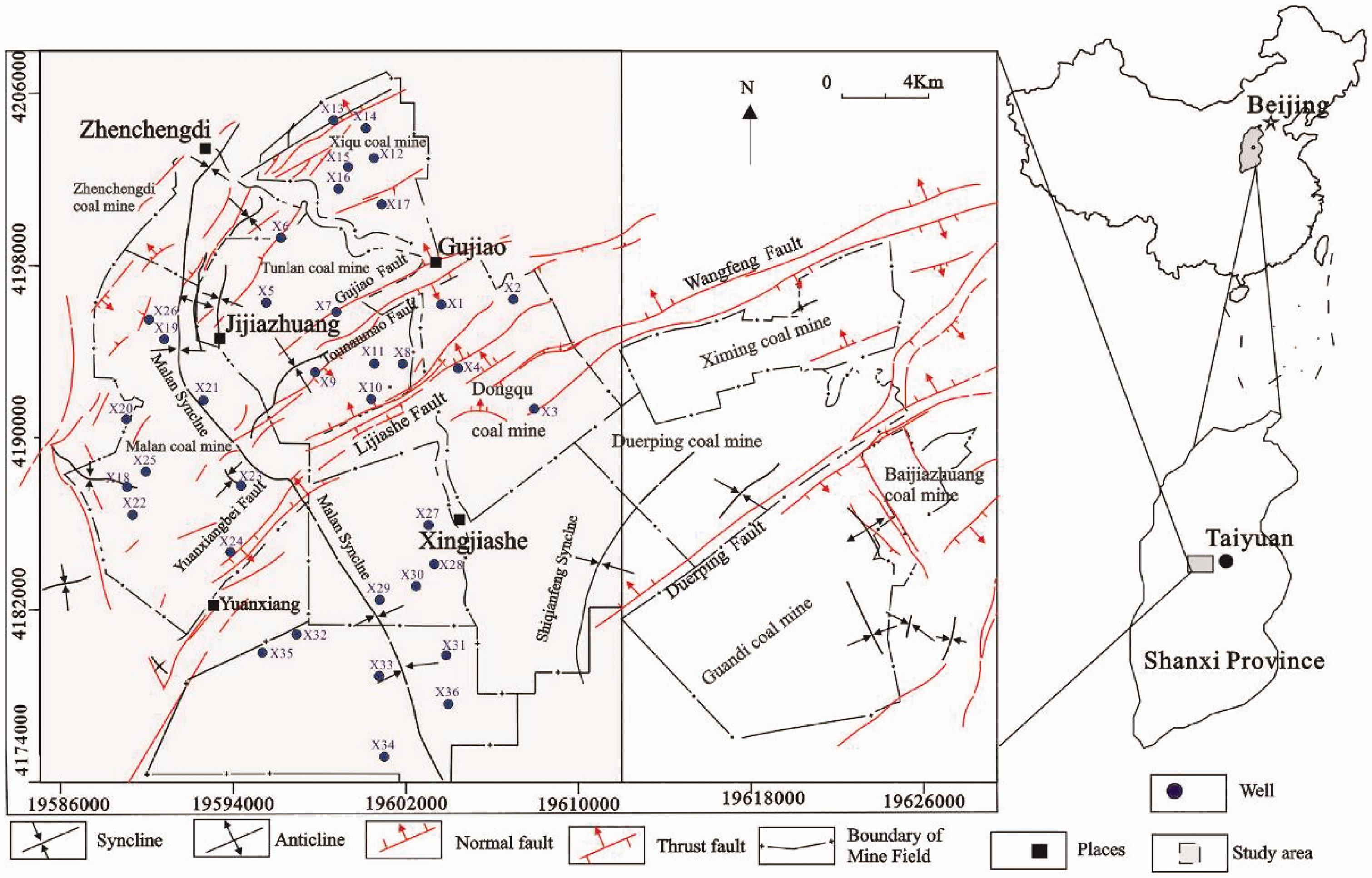
This block has experienced multiple tectonic movements and has a complex structure with developed folds and faults (Guan and Li, 2001; Wang, 1993). During the Indosinian, an SN-trending compression and uplift of the Northern Xishan coalfield resulted in a NNE-striking fold that was extremely wide and gentle. This is the basis for the Early Yanshanian, a SEE–NWW-trending compression that developed a NW- and NEE-trending shear structure that laid the tectonic framework of the Xishan coalfield. During the Middle Yanshanian, a NW-trending compression resulted in a large complex syncline and a NNE-striking fault structure. During the Late Yanshanian, NE-trending tensional shear normal faults were formed under a NNW-SSE-trending dextral extensional stress. For instance, the Gujiao-Nanmao, Wangfeng-Suilaomu, and Duerping fault zones were formed in the Gujiao block during this period. During the Himalayan, the Qingjiao and Ximing faults formed approximately parallel in the axial direction under the NNE–SSW-trending compressional stress; because of the obstruction by an ancient formation and the Yanshanian intrusions of the Huyan Mountain, the terrain acted like the Malan syncline, showing a clockwise rotation and folding in an undulating pattern. During neotectonic movement, the NNW-SSE-trending movement activated the NW-trending shear structure that formed at an early stage and formed normal faults and cut through the NE-trending faults. During this period, because of the rotation of the Ordos block, nearly EW-trending and NEE-trending faults rotated northward and formed the present tectonic pattern.
The Yanshanian is the most important period of tectonic formation and transformation in the study area with respect to the development of folds and faults. Additionally, magma heat baking in Huyan Mountain during the Yanshanian led to the volatilization of organic matter in the coal and shrinkage of the coal matrix, which generated pores and contracted fractures. Dynamic compression by magma intrusion resulted in overlaying of the exogenous fractures and endogenous fractures (cleats); this changed the scale of the fractures in the coal reservoir, increased the fracture ratio and improved the permeability (Liu et al., 2005). The development of pores and fractures in the coal reservoir was bound to reduce the strength of the coal and make it more susceptible to destruction and deformation.
The coal-bearing strata primarily comprise the Upper Carboniferous Taiyuan formation and the Lower Permian Shanxi formation in the Gujiao block (Figure 2). The Taiyuan formation is 84–136 m thick (generally 100 m thick), and the Shanxi formation is 30–70 m thick (generally 60 m thick) (Wang et al., 2015a). The target reservoirs for CBM development are the No. 2 coal reservoir of the Shanxi formation and the Nos. 8 and 9 coal reservoirs of the Taiyuan formation. In the No. 8 coal reservoir, the maximum vitrinite reflectance ranges between 1.14 and 2.30% with an average of 1.67%; the vitrinite content is in the range of 57.40–87.16% with an average of 71.67%; the inertinite content ranges from 5.67 to 34.13% with an average of 19.92%; the exinite content ranges from 0 to 1.67% with an average 0.51%; and the ash yield is in the range of 8.14–35.26% with an average of 14%.
Stratigraphic column of the permo-carboniferous coal-bearing strata in the Gujiao blocks (modified from Wang et al.).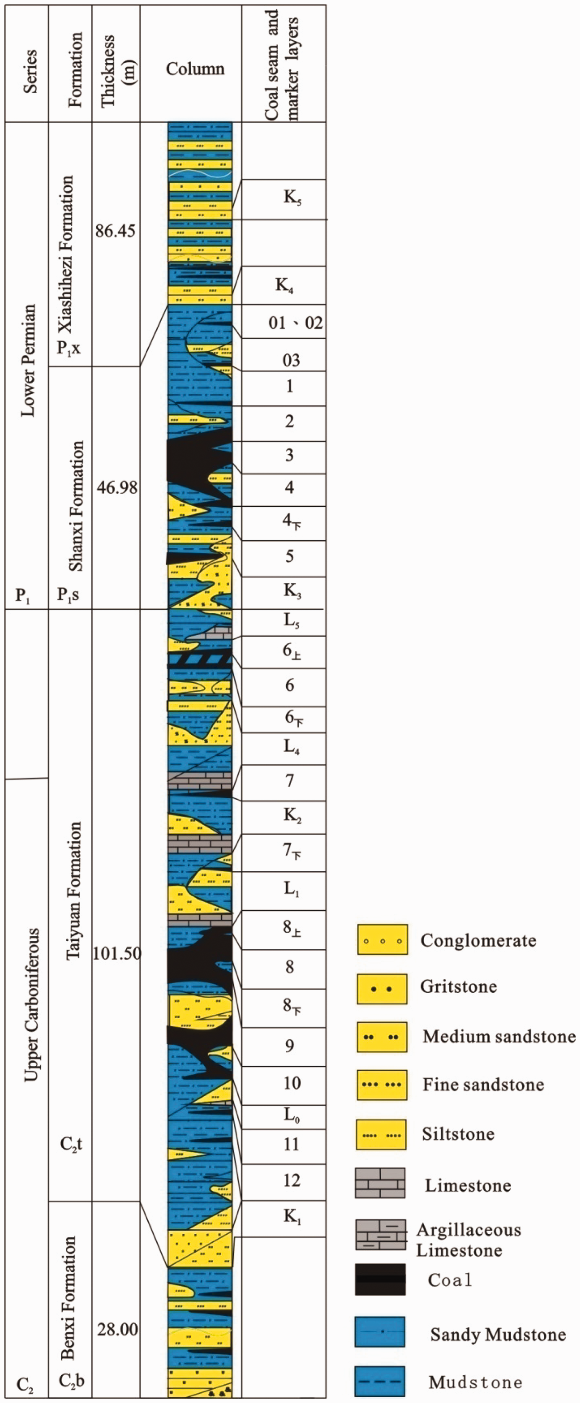
Methods of coal structure identification
Classification of the coal structure
According to the National Standards of the People’s Republic of China (GB/T30050-2013), coal structure is classified into four types—primary undeformed, cataclastic, granulated, and mylonitized—based on the macroscopic characteristics of the structure such as distinguishability of the coal rock composition, bedding integrity, coal fragmentation level, fracture and fold development level, and hand-tested coal strength. Mylonitized coal is rarely distributed within the study area; however, both mylonitized coal and granulated coal have low permeability and poor fracturability for hydraulic fracturing (Guo et al., 2014). Therefore, coal structure was classified into three types—undeformed coal (I), cataclastic coal (II), and granulated coal-mylonitized coal (III–IV)—based on the fracturability of the coal and the distinguishability of the coal structure using geophysical logging.
Log data and sensitivity of log responses
Because of the influence of various factors such as the tectonics, stress, burial depth, and coal thickness, the coal structure shows high heterogeneity in the layered and regional distributions. We selected five wells—X1, X15, X20, X32, and X34—as the calibration wells (Figure 2) to calibrate the log responses of the coal structure in the No. 8 coal reservoir. The calibration wells generally covered different tectonic zones of the Gujiao block. X34 was used as a validation well to validate the accuracy of the mathematical model established in this study for the identification of the coal structure.
The logs of the calibration wells included apparent resistivity, natural gamma, density, sonic travel time, and caliper logs. Coal-core logging and borehole observations of the coal mine showed that the coal structure of the No. 8 coal reservoir was dominated by undeformed coal, cataclastic coal, and granulated coal, with a small amount of mylonitized coal. The log response data were collected at 0.15 m intervals, corresponding to the coal structure of the calibration wells. A comparative study found that as the level of coal destruction increases, the natural gamma and density log response values decrease and the resistivity and sonic travel time-log responses gradually increase.
Box plots and Fisher’s maximum separation criterion (Formula 1) were used to screen and identify sensitive log responses of the undeformed coal and cataclastic coal, along with the cataclastic coal and granulated coal-mylonitized coal. The higher the log response value (Ij) of the coal structure, the more sensitive the log response (Wang et al., 2014). The sensitive logs were combined, and a numerical model for identifying the coal structure was established based on the principle of amplifying the log response (Xie and Fan, 2013). Similarly, the log responses of the other boreholes that had well logs but lacked an actual measurement of the coal structure because of a lack of core samples extracted at 0.15 m intervals to predict the coal structure.

Fracturability of the core reservoir
There is a normally distributed relationship between coal structure and coal reservoir permeability (Guo et al., 2010; Lv et al., 2012). A quantitative indicator of coal structure (i.e. GSI) can be used to link the relationship between these two factors (Formula 2):

The GSI value of coal is determined by assessing the distinguishability of the coal structure, the fracture development level, the crumpled mirror surface, the strength, and the development level of the coal structure surface of the different structures of the coal. The GSI value decreases as the level of coal destruction increases, i.e. 65–100 for undeformed coal, 45–65 for cataclastic coal, 20–45 for granulated coal, and 0–20 for mylonitized coal (Guo et al., 2014). As the GSI decreases, coal deformation is enhanced and the permeability exponentially increases from undeformed coal to reach a maximum in the cataclastic coal stage; thereafter, an exponential decay occurs in the granulated coal-mylonitized coal stage. Hydraulic fracturing measures can increase reservoir permeability for undeformed coal and cataclastic coal; however, the effects of hydraulic fracturing decrease permeability for granulated coal-mylonitized coal. Meanwhile, the thickness ratio of the coal structure varies in the coal reservoir, which results in differences in fracturability. Thus, we calculated the thickness ratio of different types of coal structures in the boreholes and used Q-type hierarchical clustering analysis to cluster the boreholes. We classified the coal structure type of the coal reservoir based on borehole data and further evaluated the fracturability of the coal reservoir on a regional scale.
Mathematical model for identification of the coal structure
Coal structure logging of the calibration wells
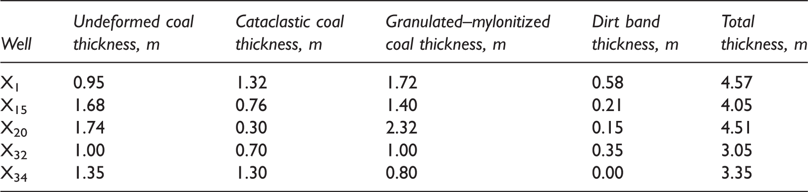
The coal structure of the calibration wells is composed of undeformed coal, cataclastic coal, and granulated coal-mylonitized coal with complex stratification (Figure 4). The coal structure and dirt band thickness in the calibration wells (Table 1) show that the wells have a coal structure that is more than 0.7 m thick, except for well X20, which has a 0.3 m thick layer of cataclastic coal that is favorable for collecting the log response data of the coal structure.
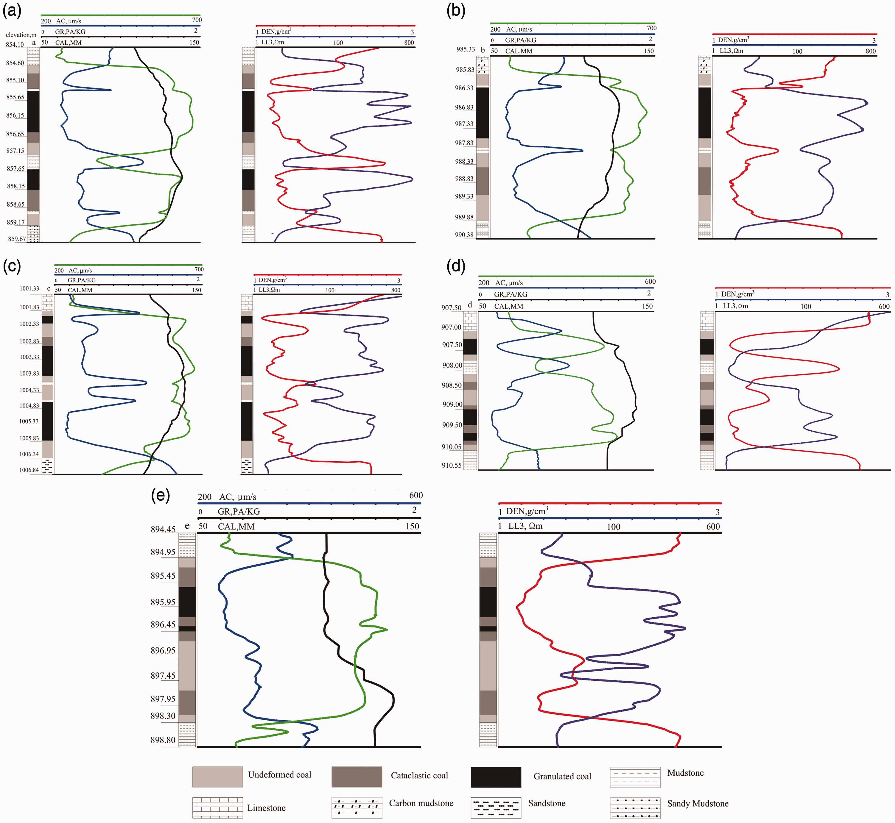
Typical macroscopic characteristics of the coal structure of the No. 8 coal seam in Gujiao block. (a) Undeformed coal (well X32); (b) cataclastic coal (X20); (c) granulated coal (X32); (d) mylonitized coal (X15). Logging curve characteristics of the No. 8 coal seam in five calibration wells. (a, X1; b, X15; c, X20; d, X32; e, X34). The coal structure and dirt band thickness of No.8 coal seam in the calibration wells.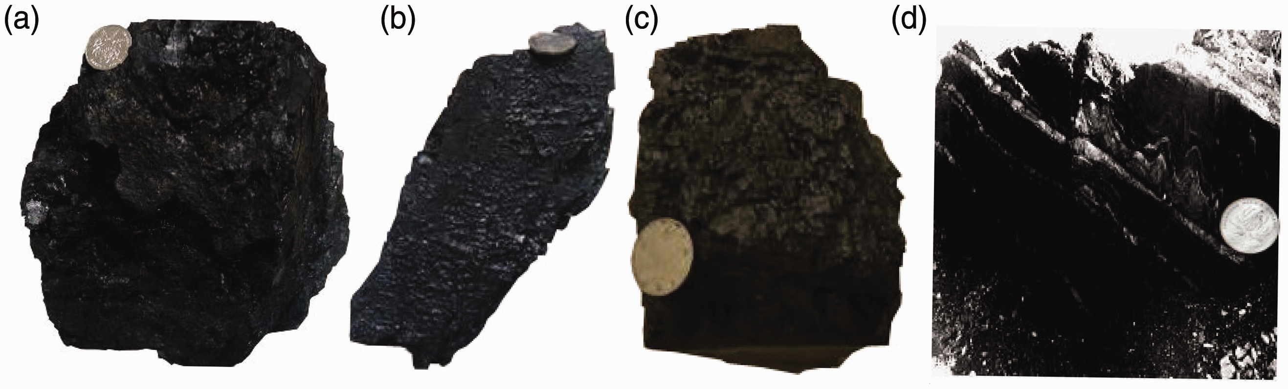
Undeformed coal has a complete, massive, wide-banded structure with little or no development of exogenous fractures from tectonic activity. This coal has no crumpled surface, and the hard coal is unlikely to break; the macrolithotype of this coal is clearly distinguishable and is generally semi-dull or dull coal (Figure 3(a)). Because of tectonization, cataclastic coal has more developed exogenous fractures and slightly dislocated beddings with slight displacements on the fracture surface. The coal is relatively complete in terms of having a massive structure. The macrolithotype of this coal is clearly distinguishable, and the coal is relatively hard and easy to break (Figure 3(b)). The granulated coal structure is severely destructed, and the coal is cut into small granules with multiple sliding surfaces (Figure 3(c)). Mylonitized coal is scaly or powdery and fractures cannot be observed by the naked eye; the coal has crumpled sliding surfaces that are highly developed (Figure 3(d)).
Log response of the coal structure in the calibration wells
The well logs of the No. 8 coal reservoir from X1, X15, X20, X32, and X34 are shown in Figure 4. For single wells, the natural gamma log and density log show consistent fluctuations as the coal structure changes; these two logs have similar shapes, and the log data have a high correlation (Figure 8). The sonic travel time log and deep lateral resistivity log data have similar results (Figure 4). The coal structure of the calibration wells has no significant caliper log responses; therefore, the caliper log is not suitable for identifying the coal structure in this area (Figure 4).
For undeformed coal, the natural gamma log shows a box-shaped negative anomaly. It is funnel-shaped because of the effects of the surrounding rocks in the roof and floor of the reservoir. The top of the curve is approximated by a gentle wavy shape. The density log is box-shaped with a high amplitude that fluctuates at the peak point. It is bell-shaped because of the effects of the surrounding rocks in the roof and floor of the reservoir. The sonic travel time log has a high amplitude, is box-shaped, and is relatively smooth at the top of the curve. The apparent resistivity log shows box-shaped positive anomalies and the curve is undulating.
For cataclastic coal, the natural gamma log has a markedly decreased amplitude compared with the undeformed coal, and the curve is box-shaped. The density log also shows markedly decreased amplitude values compared with the undeformed coal, and the curve is box-shaped with jagged fluctuations at the peak point. The sonic travel time log has a high amplitude and is box-shaped, and the top of the curve is relatively smooth. The amplitude of apparent resistivity shows no significant changes compared with the increase in undeformed coal structure, and the curve is step-shaped.
For granulated coal-mylonitized coal, the amplitude of the natural gamma and density logs is not significantly different compared with the cataclastic coal, and the curves have similar shapes. The sonic travel time log has a greatly increased amplitude compared with the cataclastic coal, and the top of the curve shows gentle wavy undulations. The apparent resistivity shows a greatly increased amplitude compared with the cataclastic coal, and the curve is convex-shaped with substantial wavy undulations at the top of it.
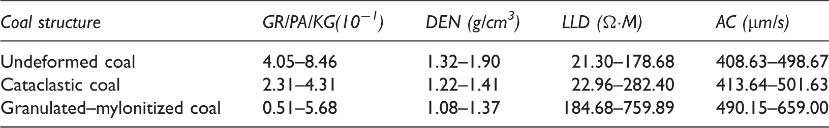
Logging intervals of natural gamma (GR), density (DEN), deep resistivity (LLD), and sonic–interval transit time (AC), ascertained by coal textures of No. 8 coal seam in five calibration wells.
Factors influencing the log responses of coal structure
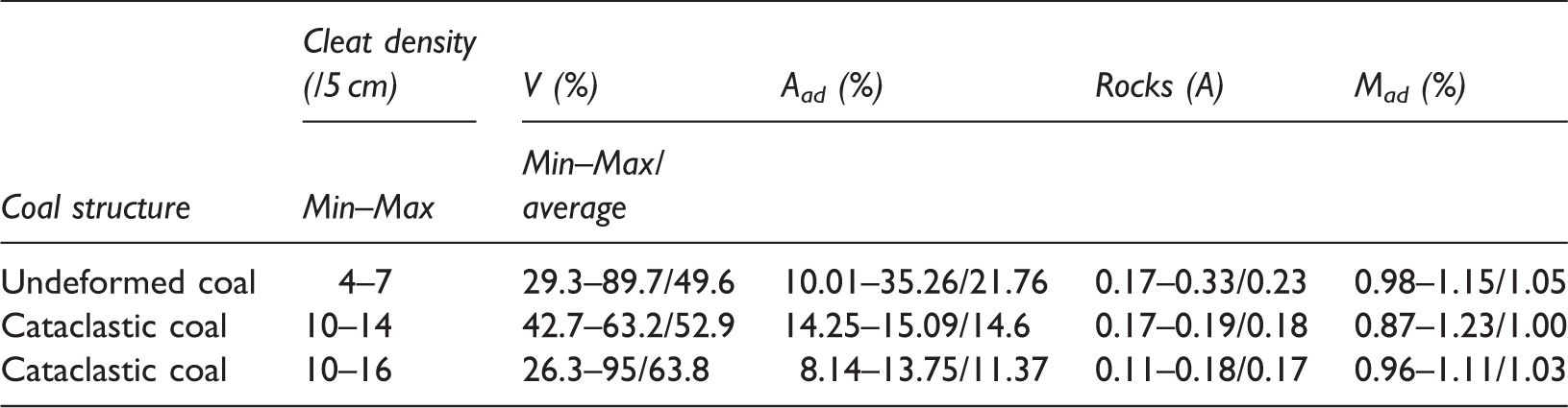
Tset date of coal structure of the No. 8 coal sample in well X32, including cleat density, vitrinite content, ash content, rocks (A), and water content.
We used the coefficient of the natural gamma radiation from the rocks (A), i.e. the total number of gamma photons emitted by the radioisotopes U, Th, and K per second per gram of rock, to characterize the natural gamma log value (Formula 3; Zhang et al., 2000). The contents of U, Th, and K were substituted into Formula (3) to calculate the dimensionless value, A, for the 13 samples from the vertical profile (Table 3).

In X32, the macrolithotype of the undeformed coal is dominated by semi-dull and dull coal with a small amount of semi-bright coal. The macrolithotype of the cataclastic coal is dominated by semi-bright and semi-dull coal. The macrolithotype of the granulated coal-mylonitized coal is dominated by semi-bright coal with a small amount of bright coal, and vitrinite content is significantly higher compared to the cataclastic coal and undeformed coal (Figure 5; Table 2). The dull coal and semi-dull coal are dense and hard with high toughness and high density; these two types of coal are less prone to destruction and deformation under in-situ stress. The semi-bright coal and bright coal have high brittleness and low density and therefore are easily broken (Xu et al., 2016). Thus, cataclastic coal and granulated coal have developed fractures with significantly increased cleat density and markedly decreased ash content and an A value comparable to undeformed coal (Figure 5; Table 2). Figure 5 and Table 2 show no significant differentiation in the inherent water content in the coal structure.
Vertical variations of coal textures of No. 8 coal coring samples, cleat density, rocks (A), water content, maceral content, and ash content in wells X32.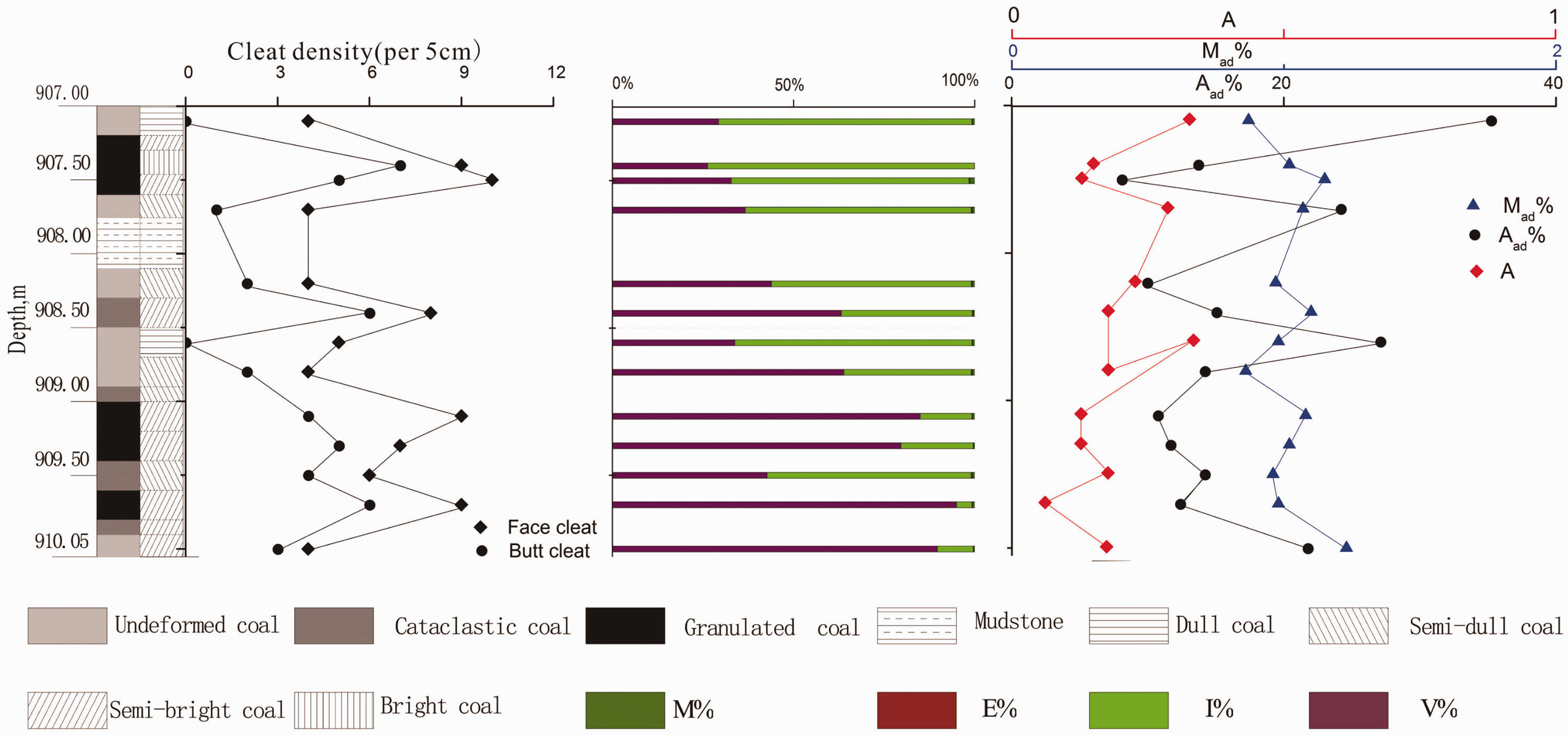
In summary, the cleat density, maceral content, ash content, and coefficient of radioactivity A of the coal structure show significant differentiation and have good correlations with the log responses (Figure 6). The undeformed coal has an intact coal seam and poorly developed fractures with a high density; it also has low sonic travel time log responses. The granulated coal-mylonitized coal is severely destructed and well fractured with a low density, and it has high sonic travel-time log responses (Figure 6(a)). The A value is positively correlated with the natural gamma value, whereas the ash content is negatively correlated with the apparent resistivity of the coal seam. The undeformed coal ranks highest for A value and ash content, whereas the granulated coal is the lowest for these two indicators. Thus, the log responses of the undeformed coal are high natural gamma and low apparent resistivity values; the log responses of granulated coal are low natural gamma and high resistivity values (Figure 6(b)).
Vertical variations of coal textures of No. 8 coal seam coring samples, cleat density, rocks (A), ash yields and logging data in wells X32.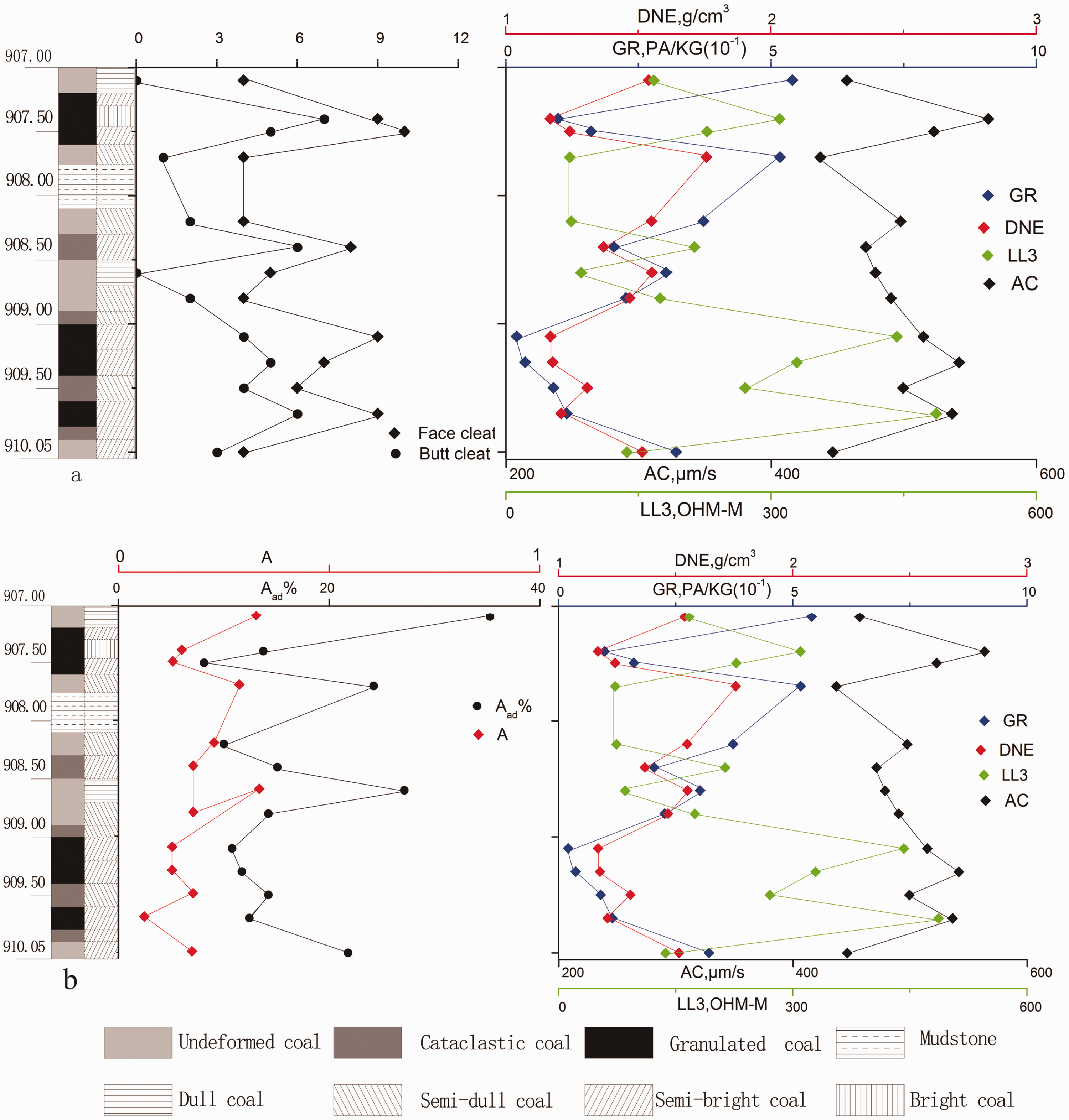
Sensitivity of log responses and identification model of the coal structure
As stated above, the macrolithotype of the coal, fracture density, ash content, and coefficient of the natural gamma radiation A value exhibit a “jump” when the coal structure changes. For instance, the fracture density of the cataclastic coal and granulated coal is considerably higher than that of the undeformed coal, whereas the values are close between the cataclastic coal and granulated coal. The log responses of the coal structure may also show similar changes.
We measured the vertical coal structure in X1, X15, X20, X32, and X34 and extracted the log responses at 0.15 m intervals in these calibration wells. Overall, we extracted the values of the density, natural gamma, apparent resistivity, and sonic travel time from 41 undeformed coal, 29 cataclastic coal, and 48 granulated coal samples. Figure 7(a) and (b) shows that the undeformed coal samples have significantly greater density log and natural gamma log values than the cataclastic coal samples; most of the data points are located above data of the cataclastic coal, with a few overlapping data points. The log data were normalized. The I values of the natural gamma, density, resistivity, sonic travel time log responses for identifying the undeformed coal and cataclastic coal are 0.09, 0.05, 0.03, and 0.004, respectively, calculated by Fisher’s maximum separation criterion. The higher the I value, the larger the difference within the same log response value between different coal structures, which identifies log response values that are sensitive enough to identify the coal structure. Thus, the sensitive responses for identifying the undeformed coal and cataclastic coal are the density and natural gamma log, followed by the resistivity log. Figure 7(c) and (d) shows that for the granulated coal-mylonitized coal, the majority of the sonic travel time and apparent resistivity log values are located in the upper portion of the vertical axis, which are significantly higher than the close log values of the cataclastic coal and undeformed coal. The AC values of the granulated coal-mylonitized coal and cataclastic coal are within the ranges of 490.15–658.99 and 413.64–501.63 µm/s, respectively, and overlap at 490.149–501.6335 µm/s; the LL3 values are 184.68–759.89 and 22.96–282.40 Ω/m, respectively, and overlap at 184.68–282.40 Ω/m. The ranges of overlap are small. For the cataclastic coal and granulated coal-mylonitized coal, the I values of the sonic travel time, resistivity, natural gamma, and density log responses are 0.07, 0.04, 0.02, and 0.009, respectively, calculated using Fisher’s maximum separation criterion. Thus, the sensitive responses for identifying the cataclastic coal and granulated coal-mylonitized coal are sonic travel time and apparent resistivity logs, followed by the natural gamma log.
A box figure of the logging response value of different coal structures in the No. 8 coal seam. Log intersections of the coal structure in the No. 8 coal seam: (a) DEN–GR log intersections; (b) AC–LLD log intersections.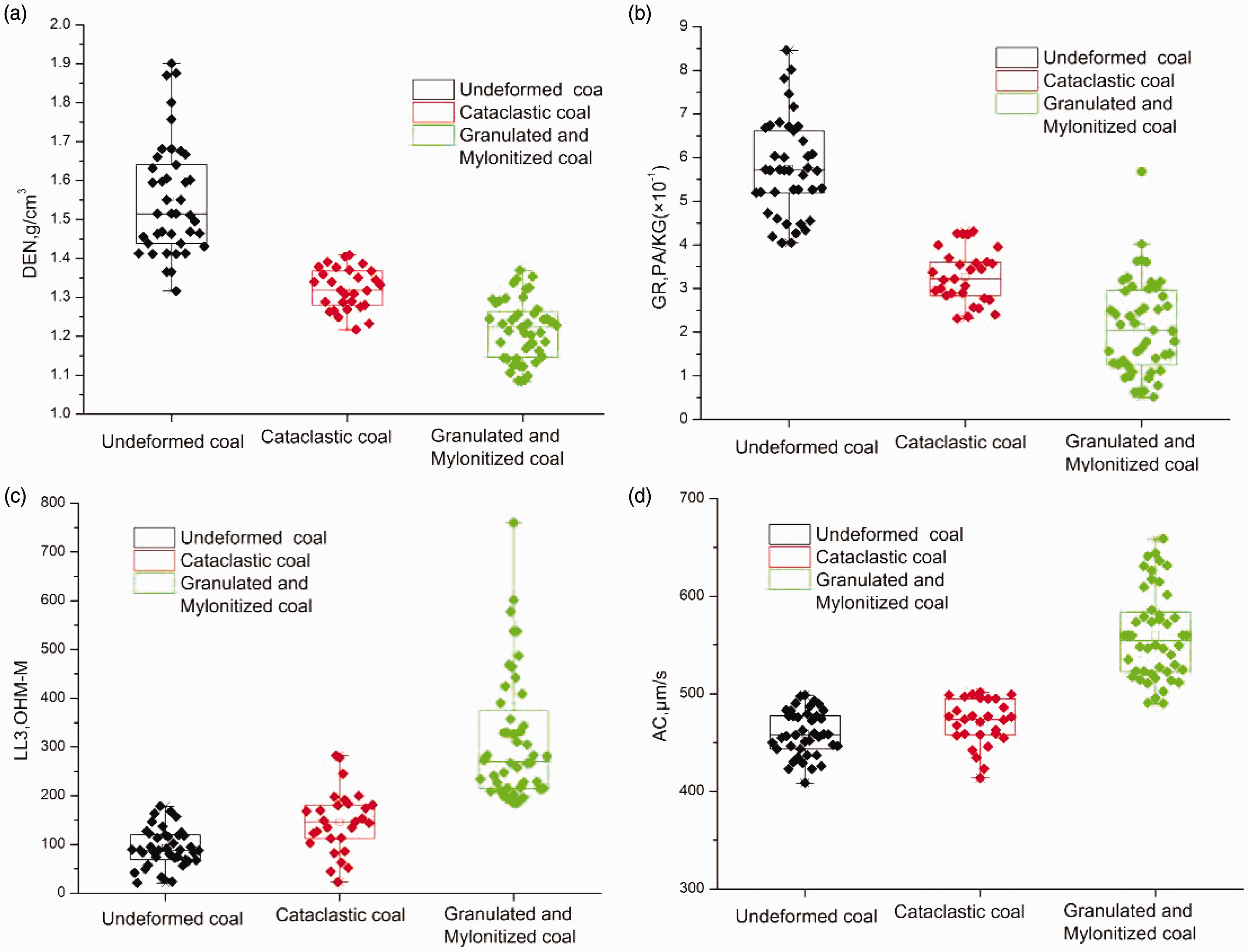
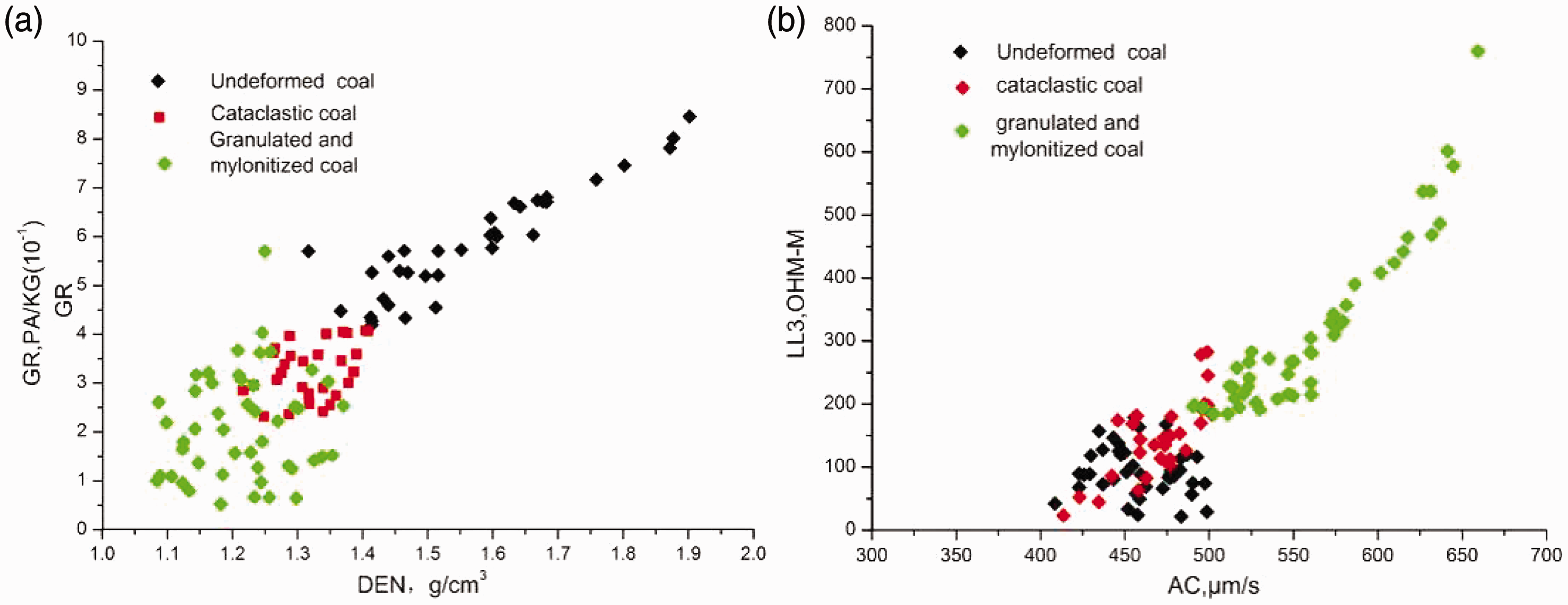
As shown in Figure 8(a), the DEN and GR values of the cataclastic coal are mainly concentrated in the middle, right of the axis, with a small span of data points. The DEN and GR values of the undeformed coal are located on the upper, left of the axis, with a large span of data points. The DEN and GR values of the undeformed coal and cataclastic coal show good linear correlations. Figure 8(b) shows that the AC and LL3 log data of cataclastic coal are mainly concentrated in the middle, bottom of the axis, whereas the data of granulated coal-mylonitized coal are located at the upper, left of the axis; the span of these data points is relatively large, and the AC and LL3 values of the cataclastic coal and granulated coal-mylonitized coal have positive exponential correlations.
In summary, the undeformed coal and cataclastic coal can be identified by a combination of DEN, GR, and LL3; the cataclastic coal and granulated coal-mylonitized coal can be identified by a combination of AC, LL3, and GR. Based on the principle of amplifying the sensitive log responses (Xie and Fan, 2013), we constructed mathematical models for identification of the coal structure based on coal structure type and obtained the coal structure identification indices n1 and n2.
The mathematical model for identifying undeformed coal and cataclastic coal is as follows:

The mathematical model for identifying cataclastic coal and granulated coal-mylonitized coal is as follows:

In Formula (4), the selection of constants a and b overcomes the interference of the less sensitive LL3 for the identification of undeformed coal and cataclastic coal and ensures that n1 of undeformed coal is greater than that for cataclastic coal. We substitute the minimum response value of (DEN × GR)/LL3 for undeformed coal and the maximum response value of (DEN × GR)/LL3 for cataclastic coal into Formula (4). When the constant a (integer) is adjusted to be 3, n1 of undeformed coal is greater than or equal to cataclastic coal. Similarly, the b value in Formula (5) b is adjusted to 2. n1 is negatively correlated with the level of coal destruction. The minimum n1 of the undeformed coal in the calibration wells is calculated to be 44.28, which means that an n1 greater than or equal to 44.28 indicates undeformed coal. n2 is positively correlated with the level of coal destruction, and the minimum n2 of the granulated-mylonitized coal in the calibration wells is 33.21, which means that an n2 greater than or equal to 33.21 indicates granulated-mylonitized coal. We extract the log data corresponding to boreholes at 0.15 m intervals. Undeformed coal and granulated-mylonitized coal are identified using Formulas (4) and (5); the remaining interval is considered cataclastic coal (Figure 9).
Comparison of coal textures from No. 8 coal seam coring (a) and the results identified from mathematical model (b) in well X35.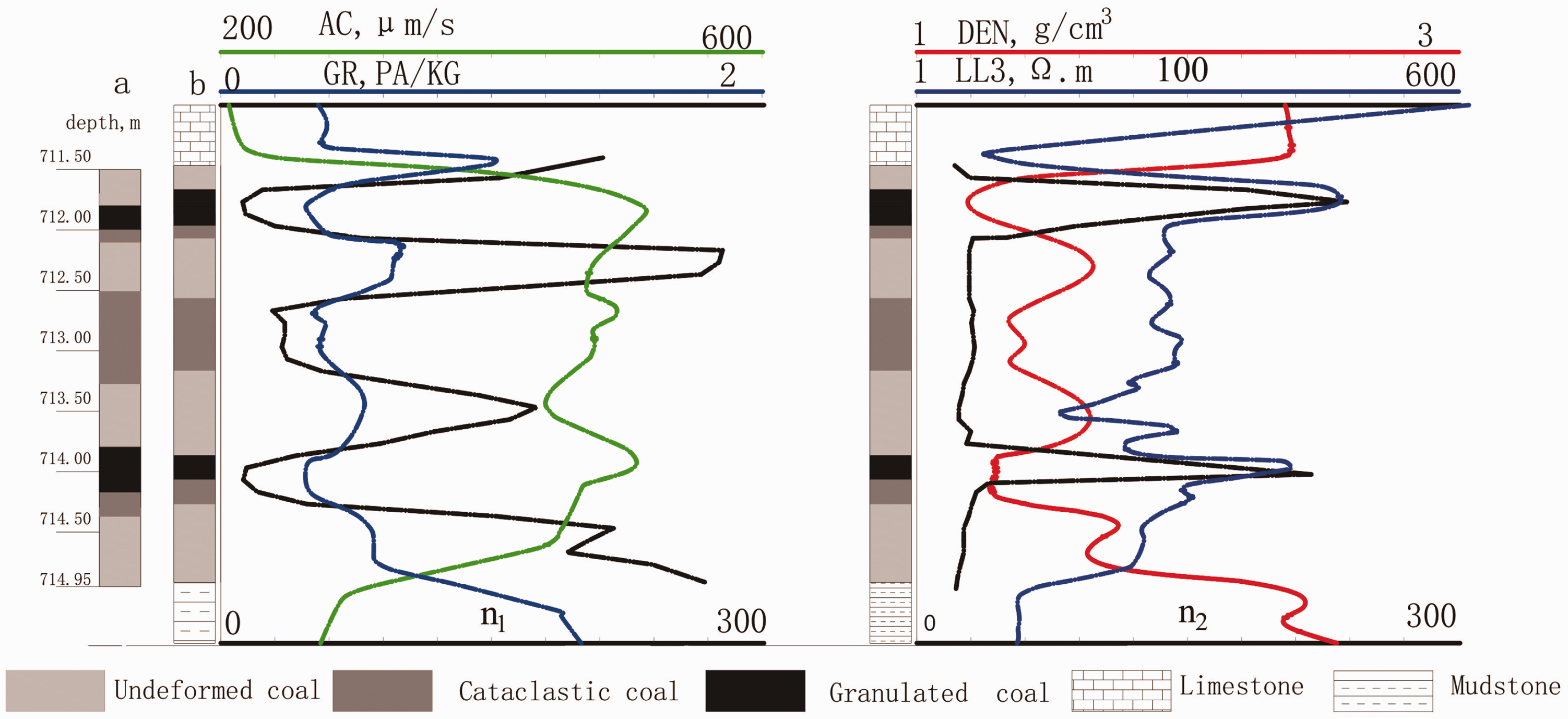
From the bottom to the top, the coal structure in the validation borehole X35 consists of undeformed coal, cataclastic coal, granulated coal, undeformed coal, cataclastic coal, undeformed coal, cataclastic coal, cataclastic coal, and undeformed coal; the coal structure identified by well logging is consistent with the measured coal structure (Figure 9). In the study area, thick limestone is commonly developed at the roof of the No. 8 coal reservoir, which has a much higher apparent resistivity than a coal reservoir, resulting in a distortion of the apparent resistivity log from the coal reservoir. The curve is finger-shaped with large undulations, which leads to uncertainties in the identification of coal structure using the log identification model. The error of identification of the coal structure in the upper part of the X35 borehole may be related to this issue.
Additionally, because of the influence of adjacent strata and the logging resolution, extraction of the log data from a coal reservoir often generates large errors at the roof and floor of a coal reservoir or a boundary between dirt bands and a coal seam. For instance, the natural gamma value reaches 0.87 pA/kg and the density is 1.90 g/cm3 at the boundary between the roof and the coal seam (Figure 9). Finally, interference from temperature, pressure, and coal seam fluids can also cause errors in the identification of coal structure by well logging, and these factors are difficult to overcome (Teng et al., 2015). Nevertheless, integrated sensitive logs can still identify the coal structure in the No. 8 coal reservoir in the study area with relative accuracy.
Distribution of coal structure and division of fracturability
Layered distribution of coal structure
Using the identification method described above, we identified the coal structure in 31 boreholes that had well logs but did not have direct observations from core sampling using the log data of the five calibration wells (Figure 10).
Vertical distribution of 36 wells’ coal textures in the Gujiao block. The results were inferred from the logging data using the mathematical model.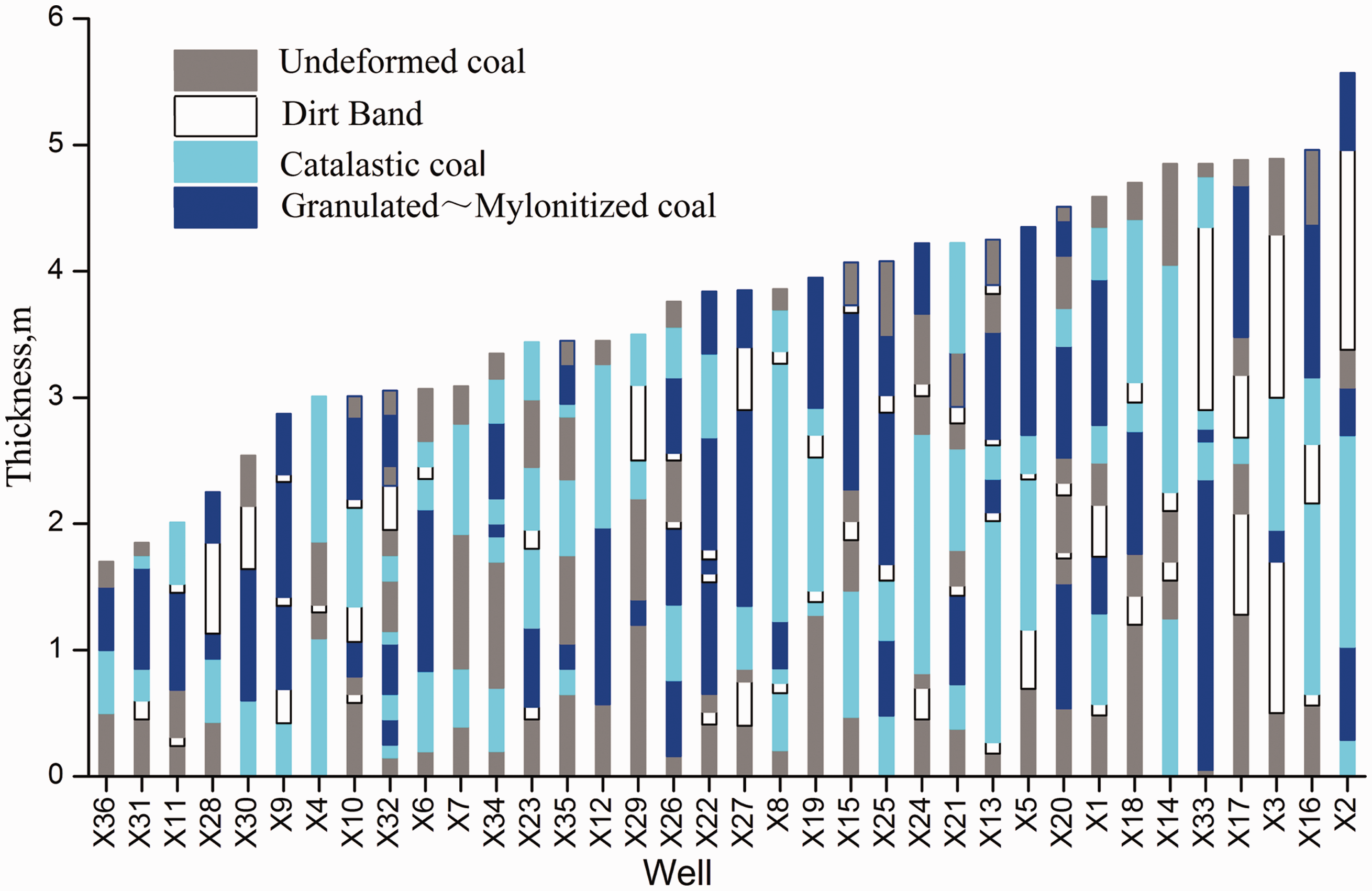
The No. 8 coal reservoir commonly contains two or three dirt bands, and the coal seam consists of 4–12 coal structures. The coal seam is primarily composed of comprises cataclastic coal and granulated coal, which alternate in layers in the middle part of the reservoir. Undeformed coal is generally developed in the roof and floor of the coal reservoir, whereas granulated coal is developed at the top of a small number of boreholes; the coal seam has a complex structure and high heterogeneity (Figure 10). The development level of the deformed coal generally has a positive correlation with the thickness of the coal seam (Qin et al., 2000). For the split coal seam, a lateral change in the thickness of the same coal seam is positively correlated with the level of the coal seam destruction (Zhu et al., 1996). In the study area, a similar conclusion is obtained by ranking the boreholes based on coal seam thickness (Figure 10). Coal seam structure has a role in coal development, which primarily limits the layered distribution of the coal (Wang et al., 2003). In this study area, one or two dirt bands are commonly developed in the coal seam, and the coal seam generally shows multiple-interlayered complex structures.
Regional distribution of coal structure
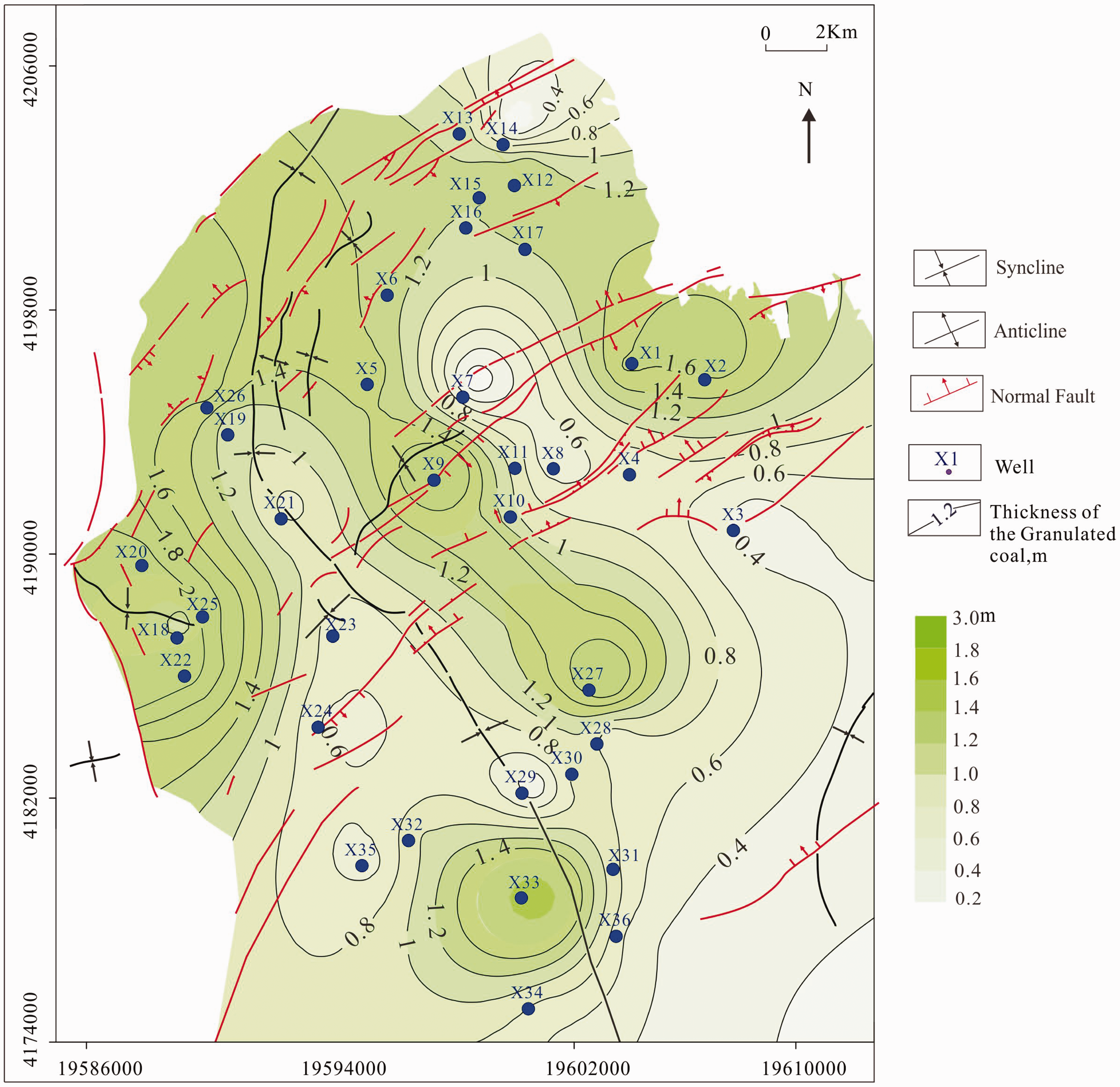
We integrated the sensitive log responses, identified the coal structure in 31 supplementary exploration boreholes, and drew the thickness contours of the undeformed coal, cataclastic coal, and granulated coal-mylonitized coal in the No. 8 coal reservoir (Figures 11, 12, and 14, respectively). Figure 11 shows that the thickness of undeformed coal ranges between 0 and 2.68 m. The coal is relatively thick in the west and northwest parts, 0.8–1.8 m, whereas the layer is relatively thin along the NE-trending tectonic zone, e.g. approximately 0.8 m in wells X1 and X9 to X25. The thickness of the dirt bands is between 0.72 and 1.72 m in the eastern and southeastern parts of the coal reservoir. Because of the influence of dirt bands, the thickness of the undeformed coal is generally 0.8 m or less, and the coal structure in the boreholes exhibits a multilayered distribution, e.g. X3, X27, X28, and X33.
Isopach map of the No. 8 coal seam undeformed coal in the Gujiao block. Isopach map of the No. 8 coal seam cataclastic coal in the Gujiao block.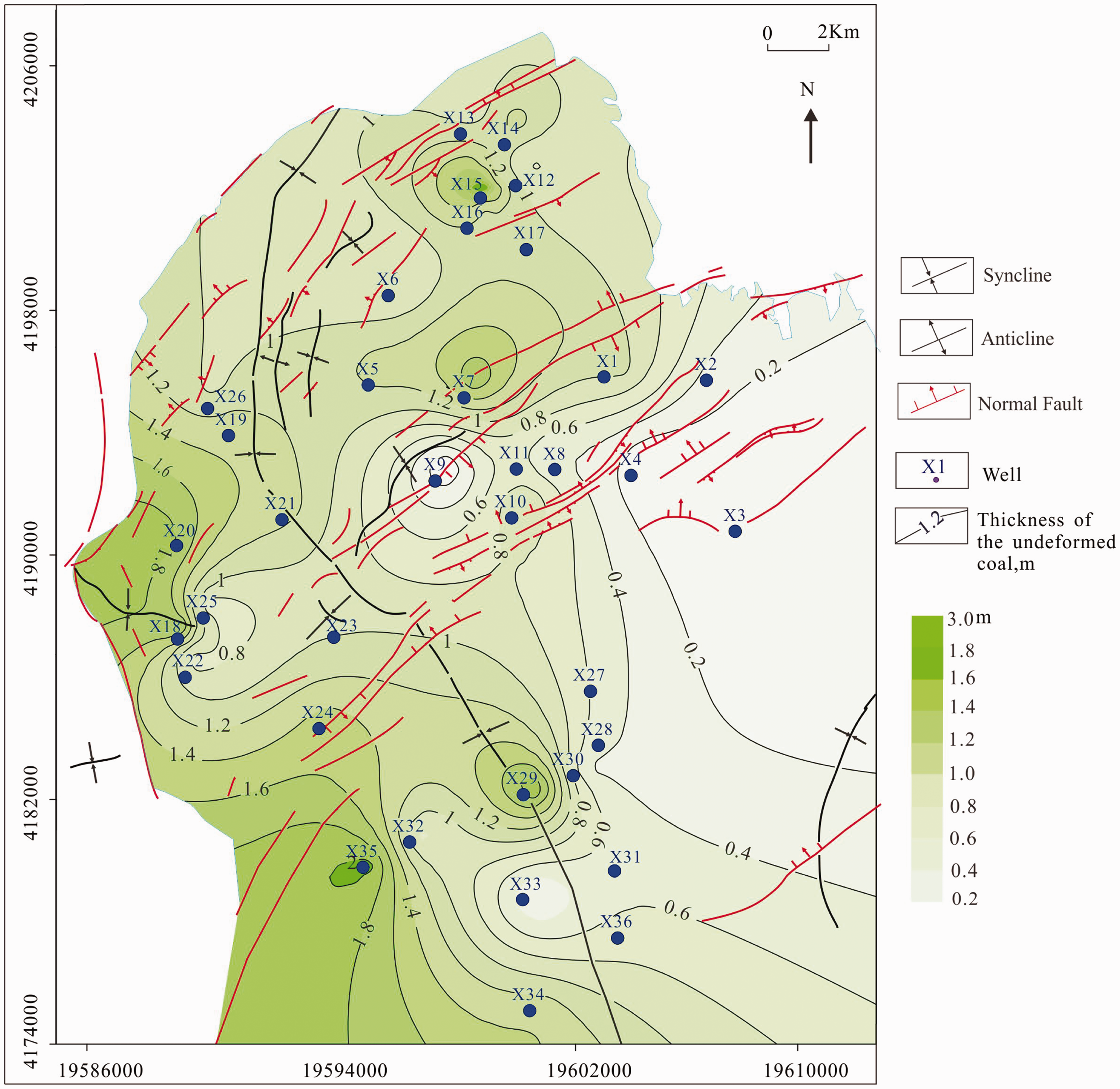
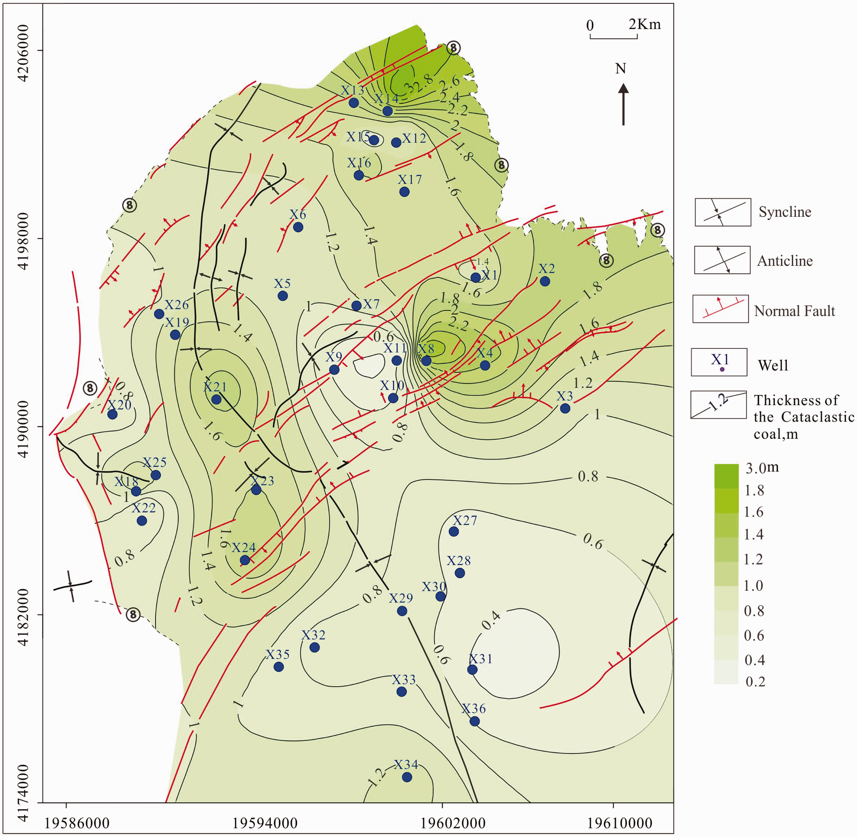
The wide gentle Malan syncline and NE-trending fault zone control the distribution of cataclastic coal in the study area. The Malan syncline is steep in the west and gentle in the east; the west wing has an inclination of 11–27° and the east wing has an inclination of 6–14°, which are asymmetrical; the NE-trending faults are intensive. Cataclastic coal is mainly developed near the axis of the NS-trending Malan syncline and the NE-trending intensive faults area. The coal seam is destructed by a relatively strong compression near the axis of the Malan syncline; for example, the thickness of cataclastic coal ranges between 1.2 and 2 m in boreholes X21, X23, and X24. Faults are intensive in the vicinity of boreholes X2, X4, and X8 in the east and X13, X14, and X17 in the northeast of the study area. The tectonic stress is relatively high, and cataclastic coal is developed with a thickness between 1 and 3 m (Figure 12). Figure 13 shows that the thickness ratio of undeformed coal to cataclastic coal exhibits a zonal distribution along the axis of the Malan syncline. The thickness ratio is relatively low and the coal seam suffers serious destruction and deformation in the two wings of the Malan syncline and the northeastern part of the tectonic development. This indicates that folds and faults are critical factors that control the coal structure in this area.
Isopach map of the thickness ratios of undeformed + cataclastic coal of the No. 8 coal seam. Isopach map of the No. 8 coal seam granulated–mylonitized coal in the Gujiao block.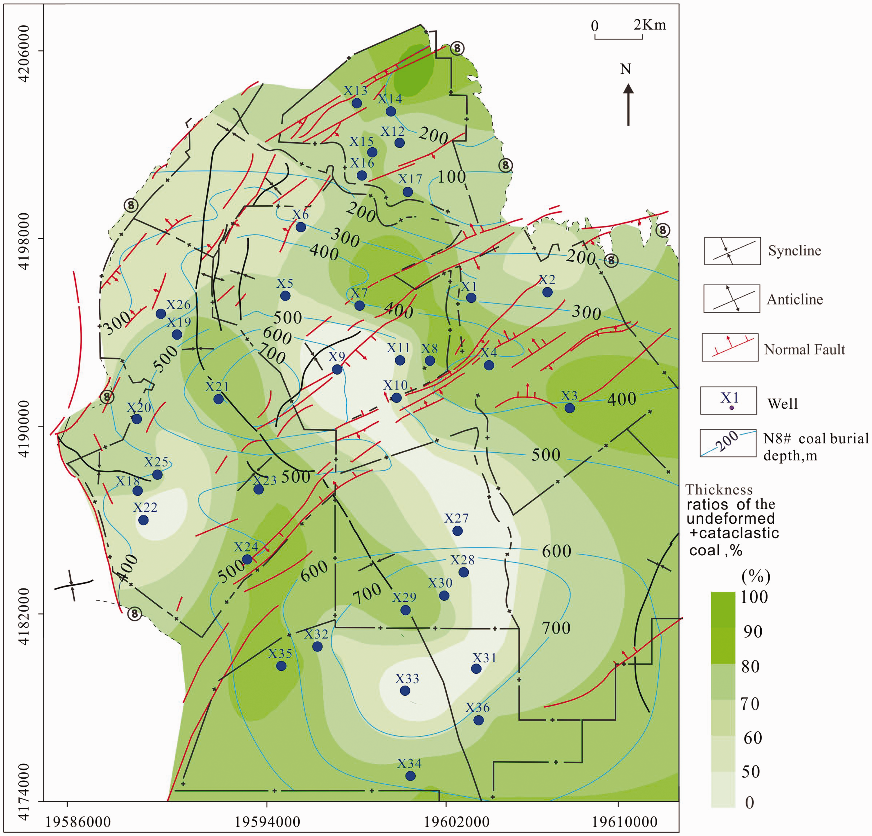
The granulated coal-mylonitized coal has a distribution similar to that of the cataclastic coal. Based on the premise of ignoring the inherent impact of coal thickness, the development of granulated coal is also affected by the NS-trending Malan syncline and NE-trending faults. The granulated coal and cataclastic coal show NS- and NE-trending alternating distributions on a regional scale. In the west wing of the Malan syncline, the coal seam has a large dip with a few faults; in the east wing, the wide and gentle coal seam has a small dip with a developed fault. The granulated coal overall shows a banded distribution along the axis of the Malan syncline. Under the effect of compression by the axis of the Malan syncline and faults on the east wing, a 1–1.4 m thick granulated coal distribution zone is formed near boreholes X9 and X27 along the axis of the NS-trending Malan syncline. The coal seam has a large dip and small faults developed near boreholes X25 and X26 at the turning end of the synclinal axis, forming another granulated coal distribution zone. Overall, because of the combined effects of the Malan syncline, faults, coal seam dip, and coal seam thickness, granulated coal is developed in the two wings of the syncline and the development level is higher in the north than in the south (Figure 14).
Additionally, the distribution of coal structure is affected by coal seam depth (Teng et al., 2015). In general, the greater the coal seam depth, the higher the geostress and tectonic stress exerted on the coal seam; therefore, the coal seam is more prone to destruction and deformation. Figure 13 shows that the trend in the thickness ratio of undeformed to cataclastic coal obliquely crosses the contour of coal seam depth. This indicates that the depth of the coal seam is not the primary factor affecting the distribution of the coal structure in this area. In the SN direction, the thickness ratio of undeformed to cataclastic coal appears to be high in the north and low in the south because it is influenced by the coal seam being “shallow in the north and deep in the south.” In the EW direction, under the control of the Malan syncline, there is no clear trend between the depth and the coal structure.
Overall, in the study area, folds and faults are developed, whereas the coal seam commonly contains dirt bands. The depth of the coal seam is shallow in the north and deep in the south, whereas the coal seam is thick in the north and thin in the south. The development of coal structure is not balanced, and the seam shows strong heterogeneity. In the southeastern part of the study area, the coal seam in the region centered at borehole X31 has small thickness, no tectonic development, and a small formation dip with no development of cataclastic coal and granulated coal (Figures 12 and 14).
Division of hydraulic fracturability of the coal seam
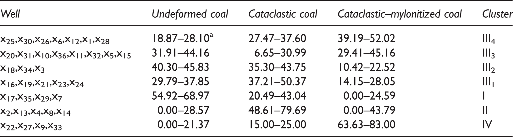
To quantitatively characterize the coal structure, Guo et al. (2014) and Lv et al. (2012) fitted a relationship between the quantitative value of the coal structure (GSI) and permeability using data from a coal structure stress-strain-permeability whole-process evolution experiment. These authors concluded that measures that improve permeability, such as hydraulic fracturing, are unsuitable for granulated coal-mylonitized coal. Based on the fracturability of the coal structure and given the strong heterogeneity and complex coal structure of the No. 8 coal reservoir in the study area, we calculated the thickness ratios of the undeformed coal, cataclastic coal, and granulated coal-mylonitized coal in each borehole and then clustered the boreholes using Q-type hierarchical cluster analysis (Figure 15). We calculated the accuracy using the weighted distance between boreholes and clustered them using the longest distance method (Wang et al., 2015b). Furthermore, 36 boreholes in the study area were classified into types I, II, III, and IV and subtypes III1, III2, III3, and III4 (Table 4). Based on the borehole types in the cluster analysis, we drew a division map of the hydraulic fracturability of the coal seam (Figure 16).
Hierarchical diagram of the No. 8 coal seam in 36 wells. Cluster results and hydraulic fracturability-divisived results of No. 8 coal seam in 36 wells. Ratio of coal structure thickness. Division map of the hydraulic fracturability of the No. 8 coal seam, Gujiao block.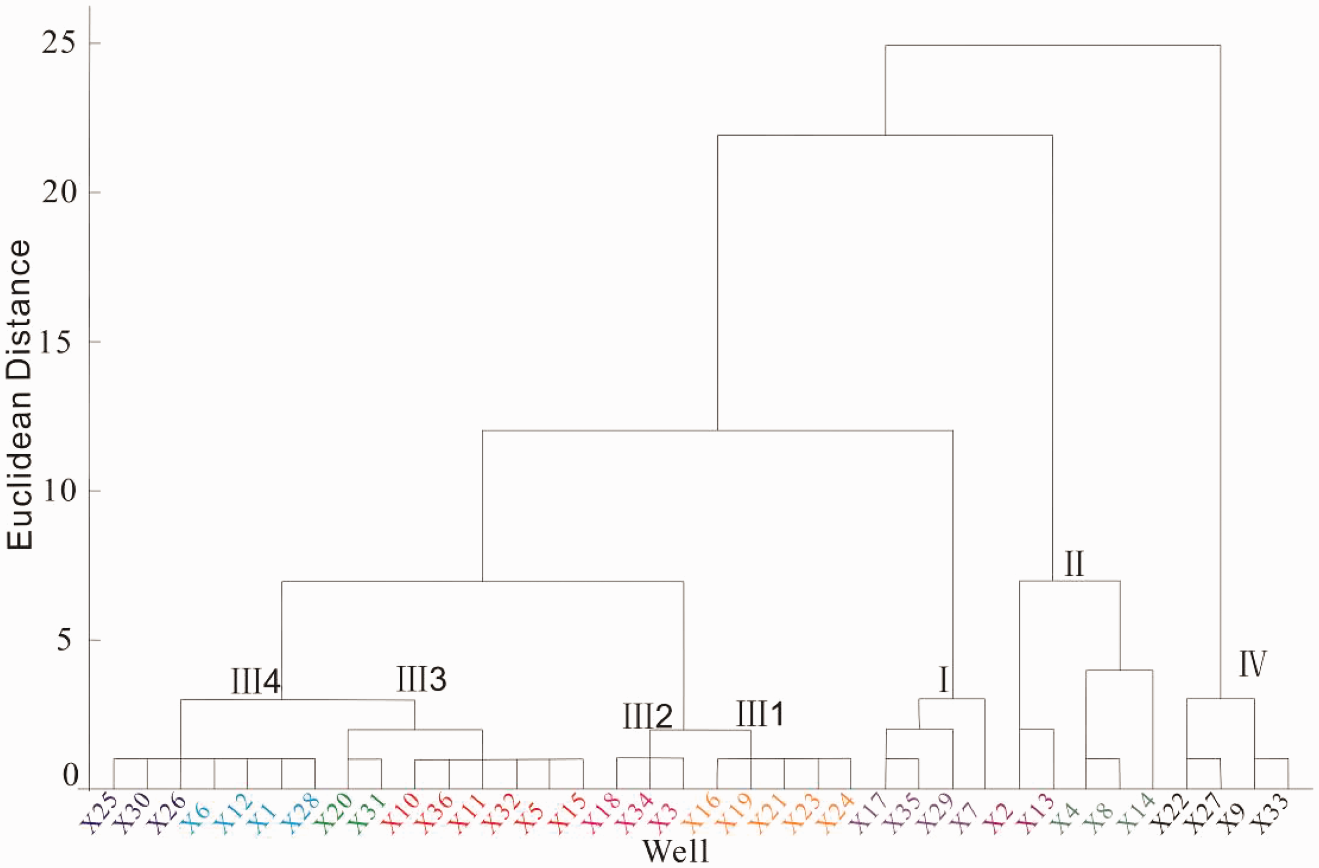
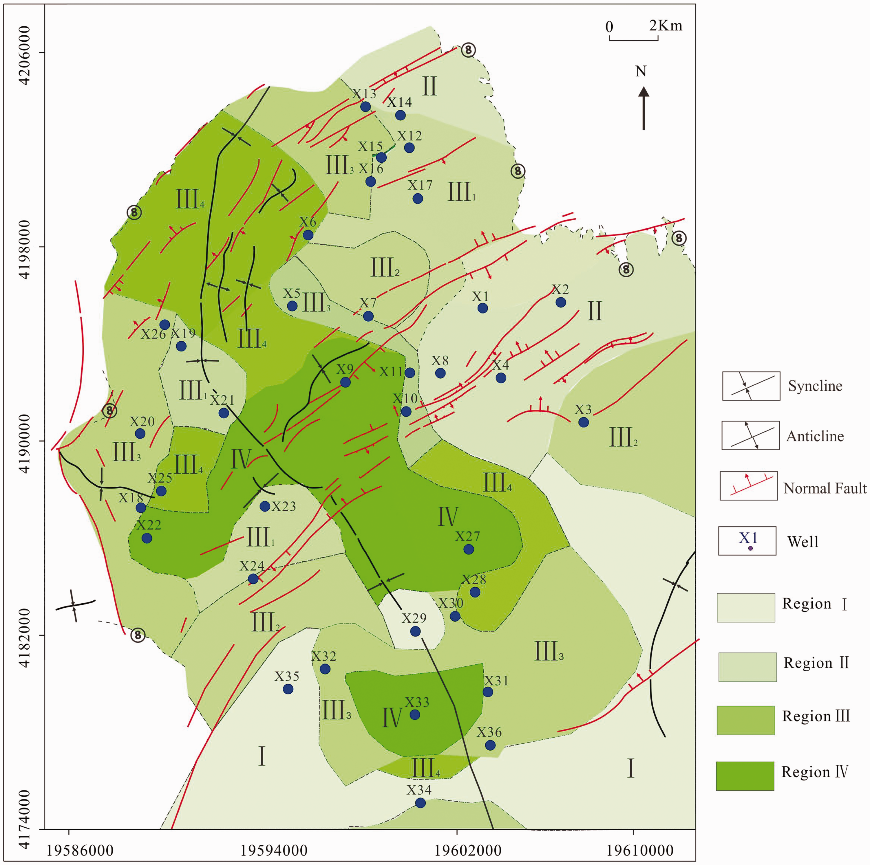
As Figure 16 shows, the type I area is distributed in the southern part of the study area on the two wings of the Malan syncline; the formation dip is gentle, and the coal seam layer is thinner than in the northern part. The coal structure is dominated by undeformed coal (55–69%), followed by cataclastic coal. The proportion of granulated coal is the lowest of the four types (Table 4). For example, the permeability of a coal reservoir based on the reservoir strength for a type I area dominated by undeformed coal can be improved using straight-well fracturing and horizontal-well segmental fracturing (Mayerhofer et al., 2008).
The type II area is distributed in the eastern and northeastern parts of the study area on the east wing of the Malan syncline where faults are developed. In this area, cataclastic coal is predominant (49–80%), followed by granulated coal; the proportion of undeformed coal is the lowest of the four types. In the type II area dominated by cataclastic coal, the coal reservoir permeability is at the optimum level. The naked-eye cave method and radial water-injection measures (Logan, 1994) are recommended for deplugging and improving the permeability of the near-borehole section.
The most widely distributed area is the type III area. It shows a banded distribution mainly along two wings and the axis of the Malan syncline. Cataclastic coal and granulated coal dominate. Based on the proportion of structural coal, the coal structure is subdivided into subtypes III1, III2, III3, and III4; as the subtype number increases, the proportion of undeformed coal and cataclastic coal decreases, whereas the proportion of granulated coal increases. Subtypes III1 and III2 are transitional types from II to III, and the coal mainly consists of cataclastic coal and undeformed coal; methods to improve the reservoir permeability were previously described for type I and II areas. Subtypes III3 and III4 are transitional types from III to IV, which can refer to the measures for reservoir permeability improvement in a type IV area.
The type IV area is mainly located at the axis of the Malan syncline. Because it was affected by tectonic stress, granulated coal dominates (64–83%), followed by cataclastic coal; undeformed coal accounts for the lowest proportion of the four types. The hydraulic fracturing technique appropriate for undeformed coal is unsuitable for this type of area, and commingling production is recommended. In this area, the coal seam and interlayer of less than 10 m were simultaneously perforated; commingling with limited-entry fracturing improved gas production two- to three-fold compared with a single reservoir (Guo et al., 2014).
Conclusions
In the study area, the macrolithotype, fracture density, coefficient of natural gamma radiation A, and ash content of the No. 8 coal reservoir show significant differentiation and discontinuity. These factors have good correlations with the log responses of coal structure and are critical factors that control the log responses of the coal structure in the No. 8 coal reservoir in the study area.
Based on the sensitive log responses of the coal structure to the physico-chemical differentiation in the reservoir, undeformed coal and cataclastic coal can be identified by natural gamma, density, and resistivity, in order of preference. The sensitive log responses for identifying cataclastic coal and granulated coal rank as apparent resistivity, sonic travel time, and natural gamma. The sensitive log responses were integrated and based on the principle of amplifying the log responses. We quantitatively identified the coal structure of the boreholes and predicted the layered distribution of the coal structure.
According to the thickness ratio of different coal structures on a regional scale, the No. 8 coal reservoir is divided into four types and four subtypes. Type I, II, III1, and III2 areas are located on the wings of the Malan syncline in the south of the study area, where straight-well hydraulic fracturing, horizontal-well segmental fracturing and the volume optimization and near-borehole un-plugging commonly used for shale gas are suitable for this reservoir. Type III3, III4, and IV areas are located around the axis of the Malan syncline. These areas of this reservoir are unfavorable for reservoir improvement using hydraulic fracturing; commingling production of adjacent seams and interlayers is recommended for these areas.
Footnotes
Acknowledgements
We would like to thank the Geology Section of the Xi Shan Coal Electricity Group and the Xi Shan Lan Yan Limited Liability Company for providing the exploration well logging data and collecting coal samples.
Declaration of conflicting interests
The author(s) declared no potential conflicts of interest with respect to the research, authorship, and/or publication of this article.
Funding
The author(s) disclosed receipt of the following financial support for the research, authorship, and/or publication of this article: The project was financially supported by the CBM Mutual Funds of Shanxi Province (2012012001) and the National Science and Technology Major Project (2011ZX05034-004), a special fund for fostering major projects at the China University of Mining and Technology (JF147424).