
Abstract
The southeastern Chongqing area, one of the highest potential shale gas accumulation areas in China, experienced strong tectonic movements. Due to the tectonic uplift in Himalayan period, the target shale formation is characterized by shallow burial depth and abundant fractures. The Lower Silurian Longmaxi shale was deposited under deep and shallow continental shelf environments with abundant pyrites and graptolite fossils. The lithology of the formation includes black carbonaceous shale, calcareous shale, and siliceous shale. The thickness of the shale varies greatly from 40 to 200 m from southeast to northwest with obvious zonation. Total organic carbon (TOC) content ranges from 1.0 to 4.0% and decreases upward in the formation owing to the change of sedimentary facies. The organic matter reaches dry gas zone. Porosity ranges from 0.5 to 7.9%, and the permeability is measured in the microdarcy to nanodarcy range. Abundant fragile minerals exist in the shales which benefit the hydraulic stimulation. Isothermal adsorption tests show that the sorption gas content in place of the Longmaxi shale ranges from 1.0 to 4.5 m3/t and the gas content in place reaches the standard of commercial exploitation. Factors impacting gas-bearing characteristics were analyzed using a mathematical statistic method, which demonstrates that TOC is the most important factor, especially to the sorption gas content. Meanwhile, clay content, thermal maturity, porosity, and mineral components are also significant factors regarding shale gas-bearing characteristics.
Introduction
With the successful application of horizontal drilling and hydraulic stimulation techniques, shale gas has become a primary energy resource. In 2013, the USA produced 3025 × 108 m3 shale gas that accounts for 44% of total gas production in the USA. To date, more than 40,000 vertical and horizontal wells are producing shale gas in 19 shale formations across the country. The successful development of shale gas resources in North America is drawing considerable attention from petroleum geologists who want to study and develop shale gas. The shale gas resources potential in mainland China, with the exception of the Qinghai-Tibet area is (23–25) × 1012 m3. Meanwhile, a number of wells have been drilled in the Sichuan Basin, the residual basins in the Upper Yangtze areas and the Ordos Basin, indicating great resource potential in China. The Upper Yangtze area is considered as one of the most promising regions for gas exploitation, and the southeastern Chongqing area has become one of five pilot areas in China. Two critical shale formations were developed during the Paleozoic the Longmaxi and Niutitang Formations. These two formations have many similarities with Paleozoic marine shales in North America, including sedimentary environments, shale thickness, and organic richness (Curtis, 2002; Jarvie et al., 2007; Li et al., 2011; Liu et al., 2011; Montgomery et al., 2005; Zeng et al., 2011; Zhang et al., 2008, 2012; Zou et al., 2010, 2014). However, the geological settings in the southeastern Chongqing area have some uniqueness, such as multi-cycle structural evolution and the higher thermal maturity.
As one of the priority shale gas investigating areas, the Chinese government has funded research on sedimentary environment, tectonic movement, geochemical characteristics and gas potential of shales in the southeastern Chongqing area since 2005. The first strategically investigated well (well YY-1) for shale gas in China was drilled in 2008 in the southeastern Chongqing area (Zhang et al., 2010). Resulting from the stress stimulation experiments, Wu et al. (2011) demonstrated that most of the fractures distributed in the areas where major faults or the axis of anticlines developed in the Longmaxi Formation. Guo et al. (2011) studied the paleoenvironment of Lower Silurian black shale based on the analysis of major elements (SiO2, Al2O3 and Fe2O3) and trace elements (Mo and U, etc.) and concluded that Longmaxi shales were deposited under anoxic reducing conditions and controlled by fluctuations in sea level. Nie et al. (2009) illustrated controlling geological and external factors on shale gas accumulations, including organic richness, thermal maturity, fracture patterns, mineral compositions, the geopressure, and burial depth. Li et al. (2013) demonstrated the lower limits of evaluation parameters for the Longmaxi shale gas accumulation in the southern Sichuan Province. The lower limits of TOC, thickness, and gas-filled porosity were calculated at 1.0%, 30 m and 1.2%, respectively. The Fuling shale gas field, which is in the central Chongqing area, was developed in 2014, with proved reserves of 1067.5 × 108 m3 to date. The successful exploitation for shale gas reveals favorable geological conditions for Longmaxi shale gas accumulations in Chongqing area.
The Longmaxi shale in the southeastern Chongqing has undergone multiple tectonic movements that cause more complexity for the geological conditions necessary for shale gas accumulations. A lot of work investigating the sedimentary environment and fracture distribution of the shale formation was done recently, concentrating on planer distribution regularity that served for selecting favorable areas and evaluating the shale gas resource potential. However, shale characteristics and gas-bearing controlling factors in this area have not been demonstrated comprehensively. This paper focuses on the critical geological characteristics on the Longmaxi shale and their comparisons with Barnett shale in the Fort Worth Basin and Marcellus shale in the Appalachian Basin. Furthermore, the critical geological parameters, such as geochemistry, reservoir property and mineralogy impacting gas-bearing shale units were analyzed to evaluate the gas content in the Longmaxi Formation of the study area.
Geological settings
Tectonic background
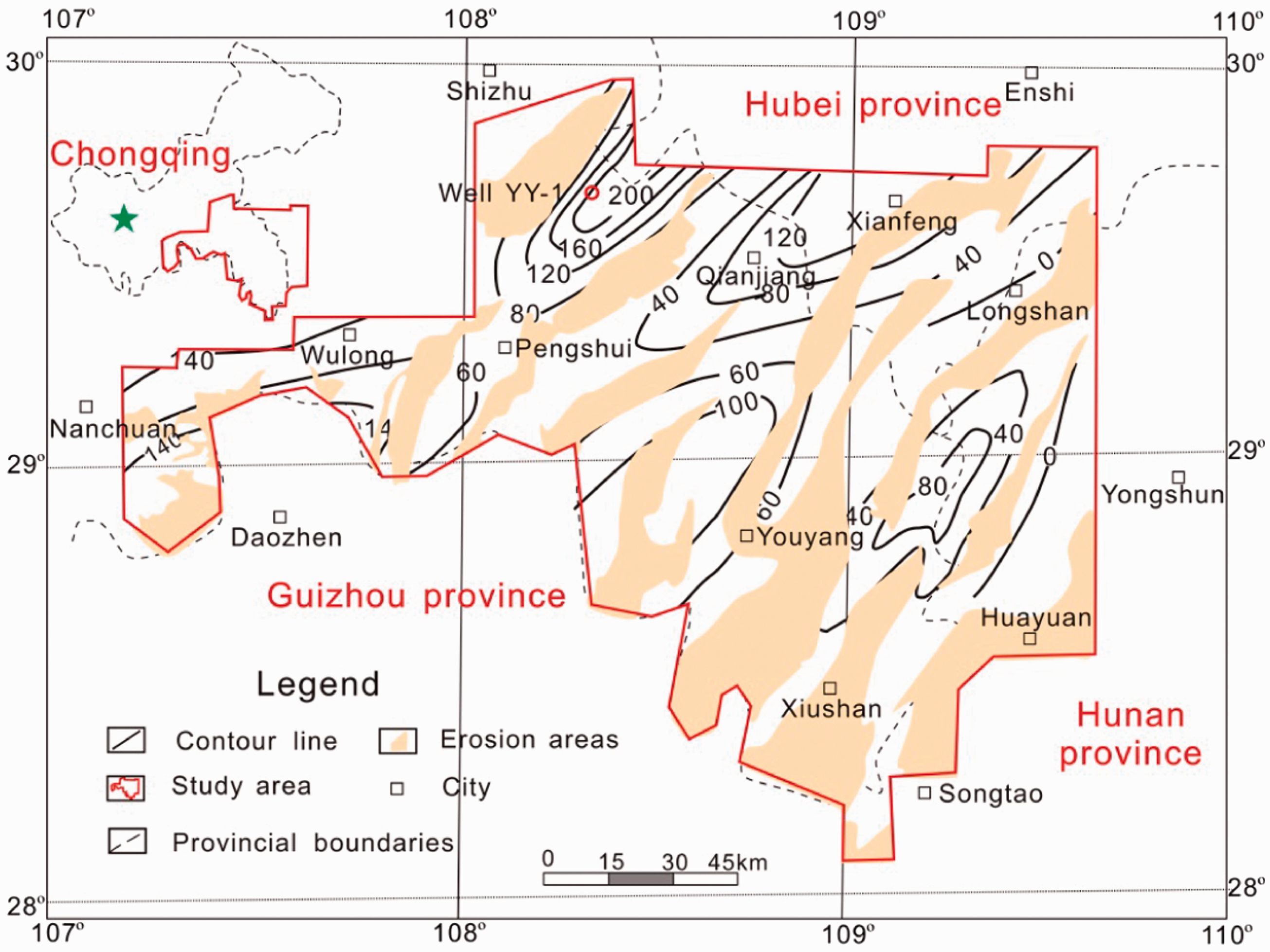
Geologically, the southeastern Chongqing area is located to the east of the Sichuan Basin in the Upper Yangtze plate, which is a residual basin due to later uplift. Geographically, this area includes the southeastern Chongqing, northern Guizhou, northwestern Hunan and southwestern Hubei Province, consisting of more than 10 counties (Figure 1). Structurally, the southeast Chongqing area is divided into the eastern Sichuan ejective fold belts and the western Hubei-eastern Chongqing trough fold belts. Most of these belts are characterized by a linear distribution with a north-northeast orientation.
Location and geological structure of the study area. The red line represents the study area and the area is also the southeastern Chongqing pilot area for shale gas exploitation in China.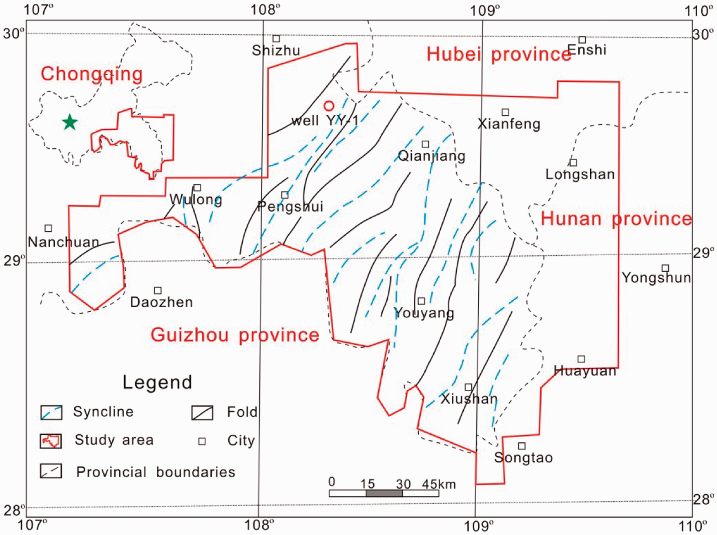
Based on its geological evolution, the study area experienced multi-cyclic tectonic movement during the Caledonian, Hercynian, Indosinian, Yanshan and Himalayan periods. This sequence was after Jinning that occurred in the Proterozoic period (Tong, 2000) (Figure 2). From the Sinian to the Early Ordovician period, the whole Middle-Upper Yangtze plate was under an extensional sedimentary environment and developed massive limestone, dolomite and detrital rocks across the area. Then, the South China oceanic plate underthrust westward, causing the collision with the Yangtze plate during the Middle-Late Ordovician and the Silurian periods. The paleo-oceanic basin on which southeastern Chongqing area is located began to close and folding occurred, developing several foreland basins and foreland uplifts in front of the orogenic belts. During this time, the Wufeng shale with abundant graptolites was developed in a continental shelf sedimentary environment.
Structural evolution of Eopaleozoic strata in southeastern Chongqing. The black bar stands for Longmaxi Formation (revised from Zeng et al., 2011).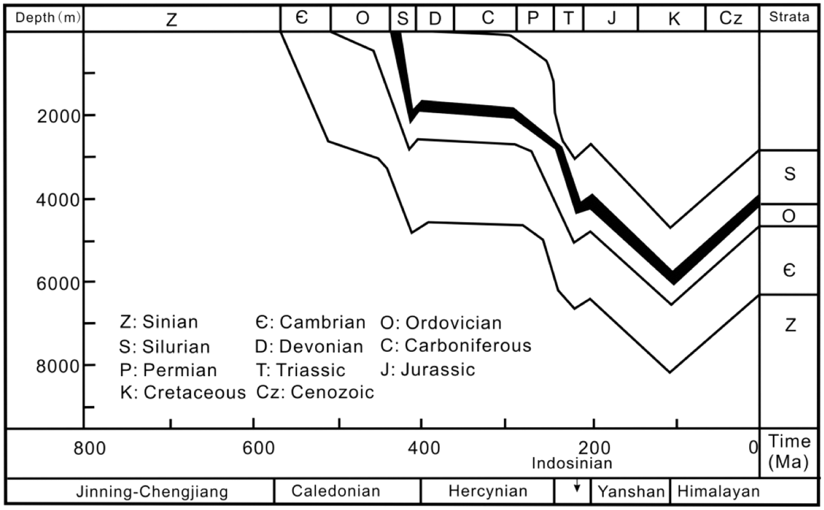
The Longmaxi Formation and the overlying Luoreping Formation were deposited in deep sea shelf and shallow sea shelf sedimentary environments in the Early Silurian period, respectively. During the Late Silurian and Late Carboniferous period, the strata were uplifted and eroded. This removed the Upper Silurian, the whole Devonian and Middle-Lower Carboniferous strata from the study area. During the Triassic period, the southeastern Chongqing area experienced intense tectonic movements that resulted from the westward compaction of the Pacific platform and formed a regional unconformity between the Middle Triassic and Upper Triassic strata, which was also called the Indosinian oregeny.
Yanshan movement continued to alter the tectonic characteristics of the study area, which resulted in the Palaeozoic strata deepening. Himalayan movement was the most important movement that determined the basic tectonic framework in the study area. The Yangtze plate subduction-collision with the Cathaysia plate during the Himalayan period resulted in compressional uplift, which formed a series of fold and fault belts in southeastern Chongqing. The strata present a regular banded distribution with the characteristics of widely spaced synclines, battlement-shaped folds and ejective folds from southeast to northwest (Figure 1). Later tectonic movements were relatively weak with only minor further reconstruction of the previous tectonic framework.
The Silurian is the most significant period of intensive geological tectonic movement during the Caledonian. Previous compression activities made the palaeohigh enlarge, which offered abundant materials for the accumulation of the Longmaxi Formation, and the rapid subsidence rate during the Upper Silurian resulted in a massive transgression of the sea, in which the organic-rich, graptolite-bearing Longmaxi shale was deposited. Later, the Longmaxi Formation evolved under the circumstances of collision and compressional movements, having experienced early subsidence and late uplift (Figure 2) (Zeng et al., 2011).
Lithology and sedimentary environments
Strata in the southeastern Chongqing area remained relatively stable while collision and compression between the South China plate and the Yangtze plate occurred beginning in the Middle Ordovician period. Those movements caused the sea to partially close and created an occluded reducing environment due to the uplifts around the study area. As the movements continued in the Wufeng period, areas of uplift enlarged gradually and the ocean narrowed, and the shallow continental shelf and shallow marginal sea environments developed. The thin black graptolite-bearing Wufeng shale developed across the whole study area.
When entering into the Longmaxi period, eustatic cycles occurred and the sea level began to increase, further deepening the water column, creating an epicontinental environment. The stratified water column and anoxic reducing conditions were beneficial for massive organic-rich shale accumulations. As a result, the Lower Member of the Longmaxi black carbonaceous shale was deposited under argillaceous shelf environment. As the accommodation space became smaller, the sedimentary environment changed into a shallow continental shelf. The Upper Member of the Longmaxi Formation mainly consists of silty shale and siltstone. Due to the development of foreland uplifts and the increase of sediment supply, the Longmaxi Formation shows an upward coarsening succession, consisting of shale, silty shale, siltstone and shale interbedded with limestone in ascending order. This succession can be interpreted as a transgressive system in the lower part and highstand system tract in the middle-upper part. Organic-rich shales occur in the lower interval, and mainly consist of black siliceous shale and calcareous shale (Figure 3).
Stratigraphy column of the Longmaxi Formation in the study area.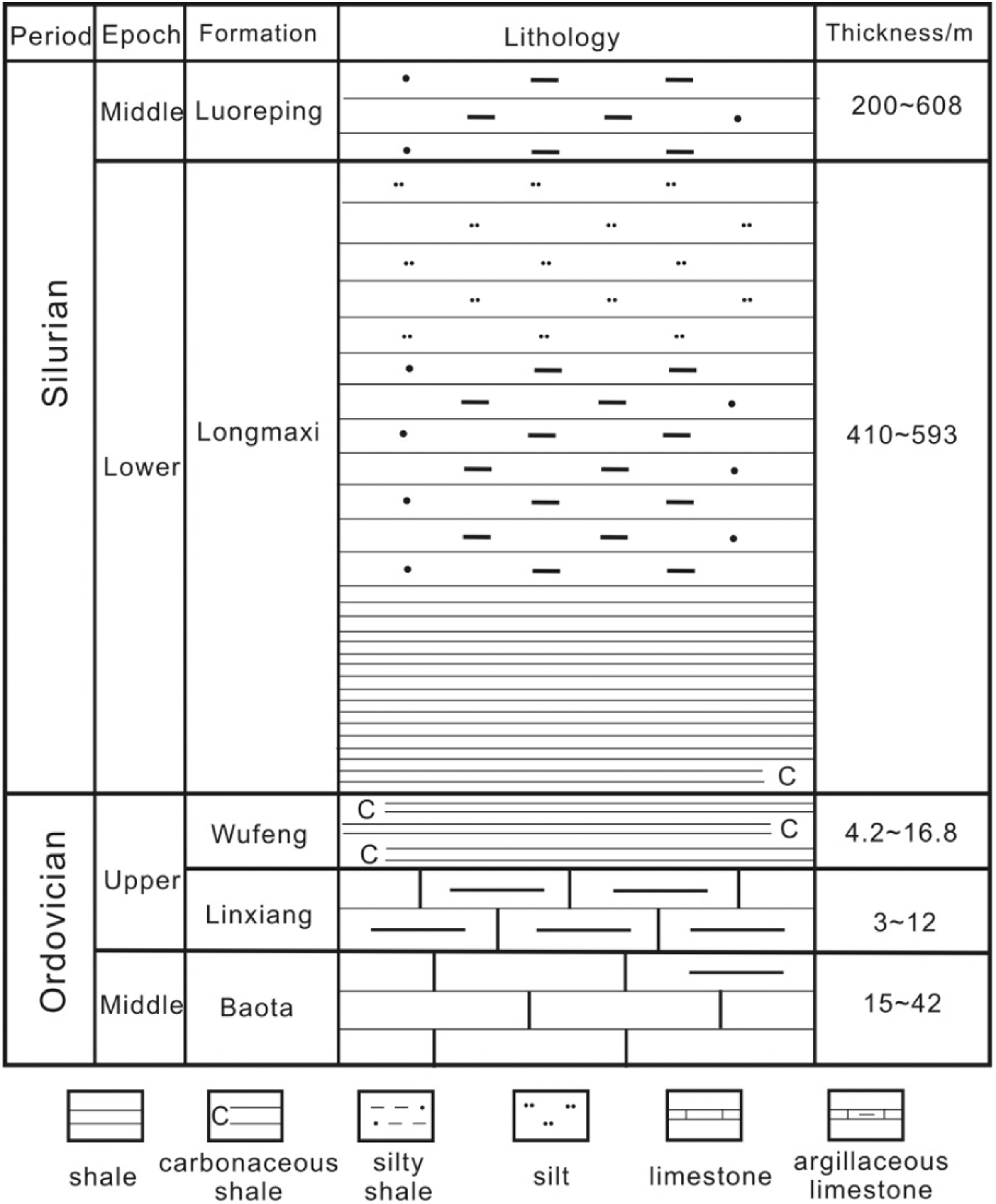
Due to later uplift, shales of the Longmaxi Formation are well exposed in the outcrops across the study area. Pyrite which was found in the shale cores is not visible in outcrop samples because of weathering (Figure 4). The depocenter was controlled by palaeo-uplifts and it influences the thickness of the Longmaxi Formation. The thickness of the Longmaxi Formation at depocenter is over 600 m and decreases outward, having the characteristics of zonal distribution after the collision and compaction. The drilling of well YY-1 showed that the Longmaxi shale has the thickness of over 220 m at that location and is considered to be one of the sedimentary centers. Because of uplifts which occurred in the surrounding study area, the thickness decreases from the depocenter to the foreland mountain belts (Figure 5).
Different types of the Longmaxi shales developed in the study area. (a) Black graptolite-bearing shale located in Pengshui County, Chongqing; (b) black-gray siliceous shale located in Huaying County, Sichuan; (c) black shale core with pyrite and calcite filling from well YY-1; (d) black shale with horizontal bedding located in Qianjiang County; Chongqing; (e) black silty shale located in Pengshui County, Chongqing; and (f) siliceous iron-bearing shale that weathers into red on surface located Nanchuan County, Chongqing. Isopach map on thickness of the Longmaxi shale in the study area. The thickness of Longmaxi shale ranges from 40 to 200 m, and decreases southeast to northwest with obvious zonation. Contour interval = 40 m.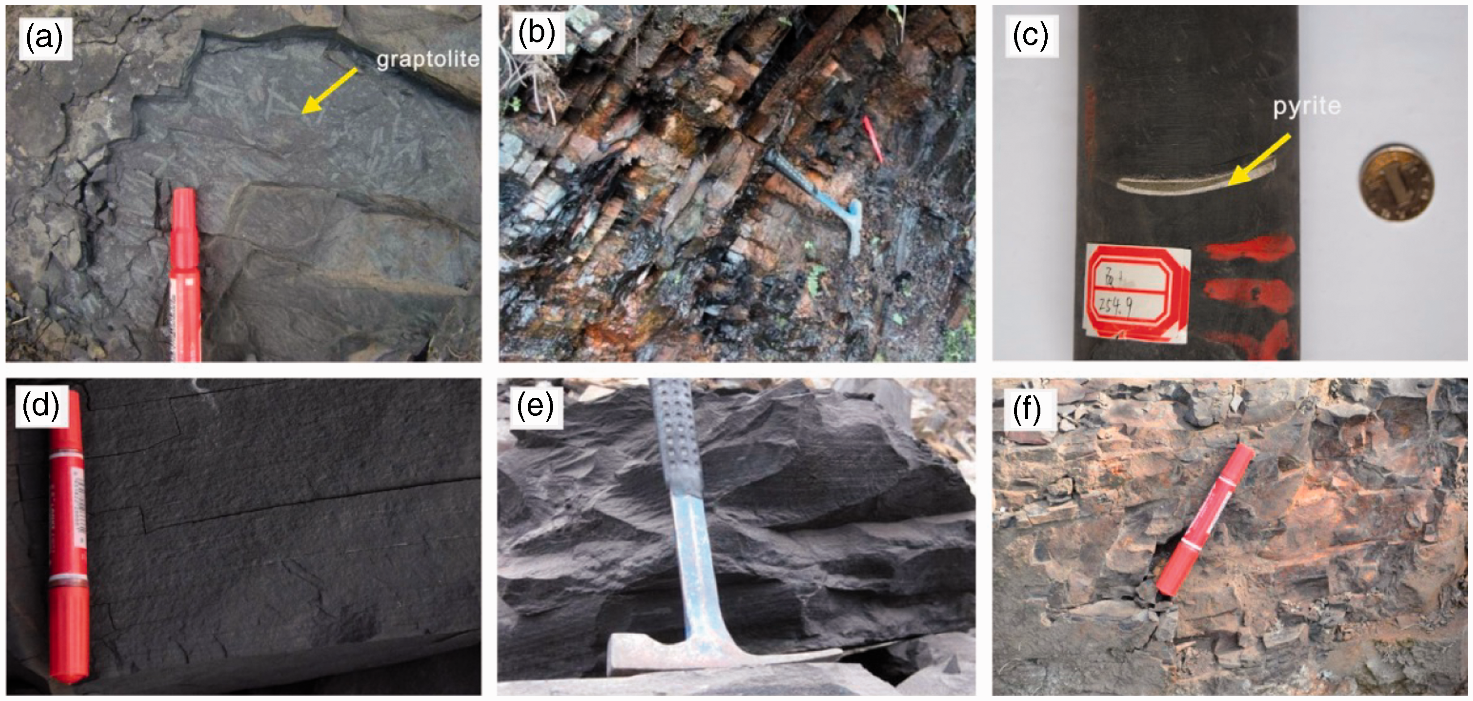
Lithologically, the Barnett Formation consists of black siliceous shale, limestone, and minor dolomite and has a thickness of 15–300 m (Loucks and Ruppel, 2007; Montgomery et al., 2005; Papazis, 2005). Loucks and Ruppel (2007) demonstrated that the Fort Worth Basin had been occupied by a narrow seaway in the Mississippian period and interpreted the Barnett shale as originating in a deep-water slope-to-basin setting. The Marcellus shale is a splintery, gray to black, carbonaceous shale with beds of limestone and carbonate concretions. Pyrite is abundant, especially near the base. Most geologists consider that the Marcellus shale of the Devonian was deposited under the conditions of an anoxic and deep-water environment (Curtis, 2002). The Marcellus Formation thickness exceeds 200 m in northeastern Pennsylvania, thinning dramatically in the west and southwest to 61 m in central Pennsylvania, and to 43 m in northern West Virginia (Wrightstone, 2008). Both the Barnett and Marcellus shales have a thickness similar to the Longmaxi shale in southeastern Chongqing.
Experiments and methods
A total of 20 outcrop shale samples across the study area and 32 cores from well YY-1 were analyzed for geochemistry, reservoir characteristics, mineral composition, and gas content in the Longmaxi shale.
All the outcrop samples and cores were sealed to measure TOC content with a Leco carbon-sulfur measurement instrument by the recommended state standard of GB/T 19145-2003. Because of insufficient vitrinite in the Paleozoic shale, bitumen reflectance (Ro) was adapted to measure the thermal maturity of the Longmaxi shale. A total of 14 shale outcrops and 24 cores were measured for Ro following the Chinese Oil and Gas Industry standard SY/T5124-1995.
A total of 19 shale samples taken from outcrops were tested for mineral composition and clay component analysis, and 22 cores from well YY-1 were analyzed for mineral composition, for which a D8 Discover X-ray diffraction instrument was implemented on the basis of the SY/T 5163-1995 standard.
Porosity and permeability of 11 cores and 20 outcrop samples were measured with an Ultrapore-200A helium instrument and an Ultraperm-200 permeability instrument following the SY/T5336-1996 standard.
The storage space for shale gas in the Longmaxi shale was studied macroscopically and microscopically. Fractures and pores can be seen in outcrop and core samples. Pores of nanometer scale and microfractures were observed under a scanning electron microscope (SEM). A total of 20 outcrop samples were analyzed to observe microfractures and pores under the Tescan Vega-II SEM. Five cores were polished with argon-ion in the State Key Laboratory of Petroleum Resources and Prospecting to better observe the pores at nanometer scale under the high resolution SEM.
Additionally, isothermal sorption experiments of 12 shale outcrops and 21 cores from well YY-1 were conducted to evaluate the sorption ability for the Longmaxi shale following the GB/T19560-2008 standard.
Results and discussion
Curtis (2002) demonstrated that shale reservoirs with commercial production exhibited a wide variation in five key parameters: (1) reservoir thickness; (2) TOC; (3) thermal maturity; (4) volume of gas in place; and (5) fraction of sorption gas. He also pointed out the common characteristics of very low permeability and fracture, which are both controlling factors in gas producibility. TOC content is most commonly used to measure the organic richness of kerogen, while vitrinite reflectance (Ro) is the measure most commonly cited to assess thermal maturity.
Geochemistry
It is important to analyze geochemical parameters such as the type and abundance of organic matter and thermal maturation, when examining shale gas accumulations (Hill et al., 2007; Zhang et al., 2004, 2008). Jarvie et al. (2007) found that the total amount of organic matter and the thermal maturation of shale were important parameters in the production of shale gas. Hill and Nelson (2000) demonstrated that the accumulation of shale gas was influenced by the organic carbon content, thermal maturity, shale thickness and gas content.
TOC content in well YY-1 ranges between 1.4% and 7.3%, and the average is 3.2%. The value of TOC is greater at the depth of 230–270 m in the Lower Member of the Longmaxi Formation (Figure 6). The Ro of shales in well YY-1 ranges from 1.6 to 3.2%, averaging 2.1% in the dry gas zone (Figure 6). TOC content from outcrop samples ranges from 0.12 to 5.53%, and most values are below 1%, which may result from long-term weathering and erosion (Sun et al., 2002). Ro value in shale outcrops concentrates in the range of 2.44–3.68%, averaging 2.77%, which is slightly higher than that in well YY-1 cores.
TOC and Ro distributions in well YY-1.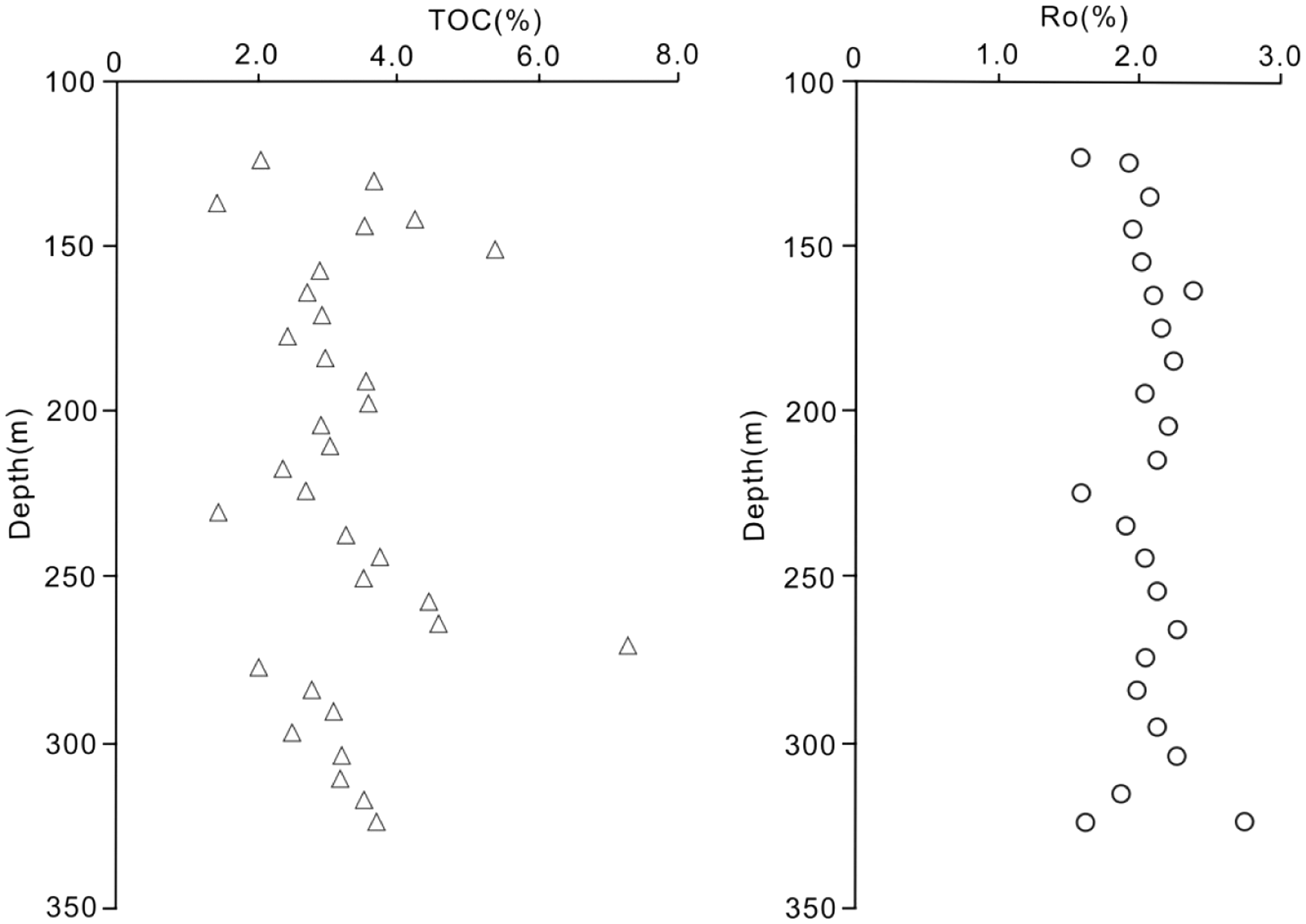
The TOC content in the Barnett Shale is reported to average 3.3–4.5% by Montgomery et al. (2005) and 2.4–5.1% by Jarvie et al. (2007). Values of TOC can reach 11–13% in the Barnett shale from outcrop samples because of immaturity (Jarvie et al., 2007). Montgomery et al. (2005) demonstrated that Ro values ranges from a minimum of less than 0.7% near southern and western margin of the Fort Worth Basin, to a maximum of greater than 1.7% along the Ouachita Thrust belt at the greatest depth for the Barnett shale. The TOC content for the Marcellus black shale is reported to be 2–10% by Wrightstone (2008). Ro has been published by Wrightstone (2008) with values increasing from a minimum of 0.5–1.0% in eastern Ohio to a maximum of 3.0–3.5% in eastern Pennsylvania.
The TOC contents in the Longmaxi shale cores are over 2% and up to 7.3% locally, which is equivalent to those of the Barnett and Marcellus shales. In contrast, the TOC contents of outcrops in North American marine shales are higher than those in the Longmaxi outcrops. Because the shales in southeastern Chongqing experienced deep burial, the organic matter cracked into hydrocarbon. Surface weathering after uplift probably decreased the TOC content (Sun et al., 2002).
Kerogen of the Longmaxi shale in the Middle-Upper Yangtze plate was reported to be Types I and II by Zhang et al. (2011) based on kerogen carbon isotopes ranging from −27.64 to −31.87‰, and was considered to be similar to the North American shales with commercial gas production. Liu et al. (2011) demonstrated that the kerogen of the Longmaxi shale in eastern Sichuan Basin was Type II. The Barnett kerogen is Type II with a minor admixture of Type III, whereas the Marcellus kerogen has a slightly greater mixture of Type III (Bruner and Smosna, 2001).
Compared with the Barnett shale, the thermal maturity of the Longmaxi shale is high and the organic matter belongs to the dry gas zone. The Ro value is equivalent to the Marcellus shale developed in the eastern Appalachian Basin. In some other shales producing commercial gas, such as the Fayetteville, Montney and Woodford shales, Ro also reaches a maximum of over 3%. Accordingly, the high thermal maturity in the study area may be not an adverse factor to the shale gas accumulation in the Longmaxi Formation in southeastern Chongqing.
Reservoir properties
Pores and fractures in shales can offer storage space for shale gas accumulation and are critical for shale gas exploitation (Jing, 2014). Various fractures such as microfractures, X-shaped joints and small-scale faults are found in well YY-1 cores, and slickensides and fault gouge also develop when faulting occurs. Fractures are filled or partially filled by quartz, calcite or pyrite (Figures 7(a) and (b)). Some pores or fractures are filled by both pyrite and calcite (Figure 7(c)). Many fissures can be seen when water washing the well YY-1 cores (Figure 7(d)). Based on thin section observation, many crossover fissures and parallel fractures exist (Figure 7(e)). Dissolution pores can be observed in the outcrop shales with the aid of the SEM (Figures 7(f) and (g)). Organic pores are visible and lots of organic interconnected pores developed in the cores from well YY-1 (Figure 7(h)). These pores and fractures will offer abundant amounts of space for free gas storage and form “sweet spots” for production of commercial gas. Moreover, these pores and fractures can largely enhance the possibility of shale gas exploitation.
Various pores and fractures developed in cores from well YY-1 and outcrops. (a) Fractures with calcite filling in core from well YY-1 at a depth of 284.7 m; (b) X-shaped joints developed and filled with calcite in core from well YY-1 at a depth of 270.0 m; (c) crumpled bedding plane was filled with both calcite and pyrite in core from well YY-1 at a depth of 257.6 m; (d) microfractures developed in well YY-1 core after water washing; (e) interaction of fractures filled with calcite under microscope; (f) dissolution pores developed in Longmaxi outcrop shale in Nanchuan County; (g) dissolution pores developed in Longmaxi outcrop shale in Qianjiang County; and (h) organic pores developed in well YY-1 core.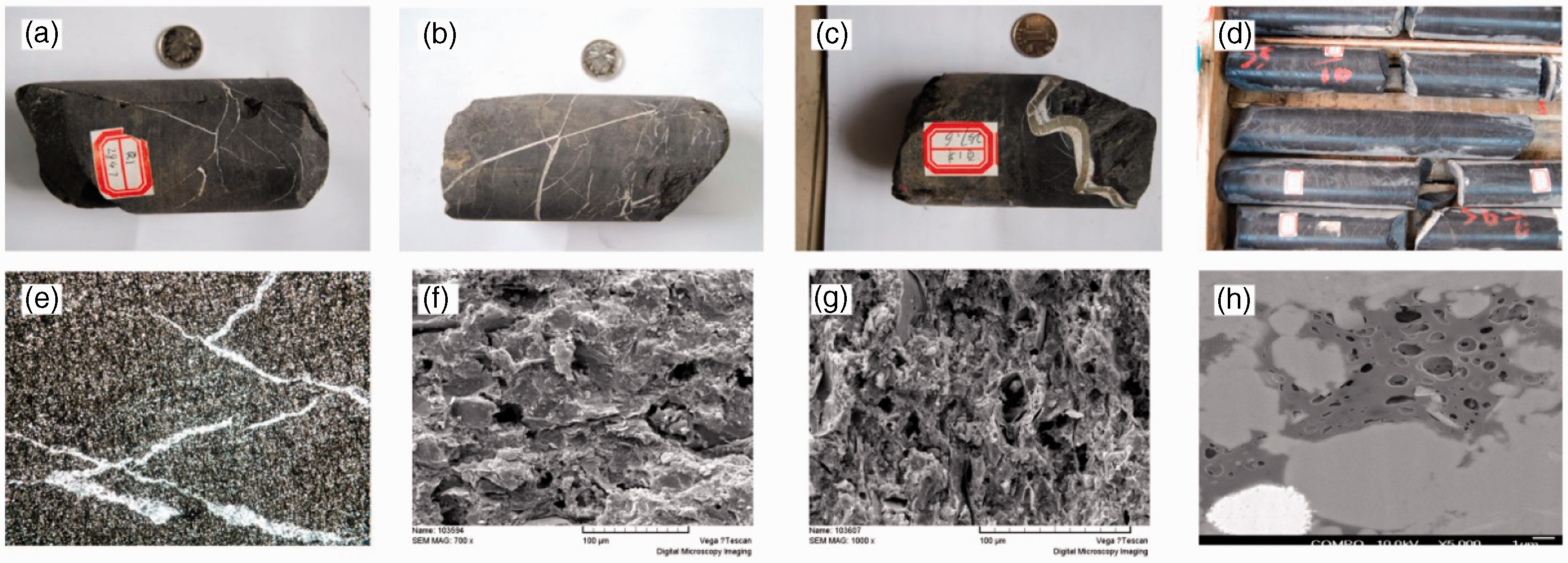
In southeastern Chongqing, the average porosity for the Longmaxi shale is 2.97% and most porosity is below 4% (Figure 8(a)). The range of permeability of outcrops is 0.0026–0.0328 mD, and the mean value is 0.01 mD. The permeability is similar to those of shale cores from well YY-1. Porosity in shale cores ranges from 0.5 to 7.9% (averaging 2.5%). Permeability for well YY-1 shale cores is between 0.0016 mD and 0.175 mD (mean 0.01 mD). Positive correlation exists between porosity and permeability for shale cores (Figure 8(b)). The porosity of outcrop samples ranges from 0.77 to 5.4% (mean 3.2%). Shales from the outcrop across the study area have greater porosity than those in the cores, probably resulting from the weathering and stress release after uplift.
Reservoir physical properties of shale across the study area. (a) Distribution frequency of porosity; and (b) relationship between porosity and permeability. A slight positive correlation exists between porosity and permeability for the Longmaxi shales.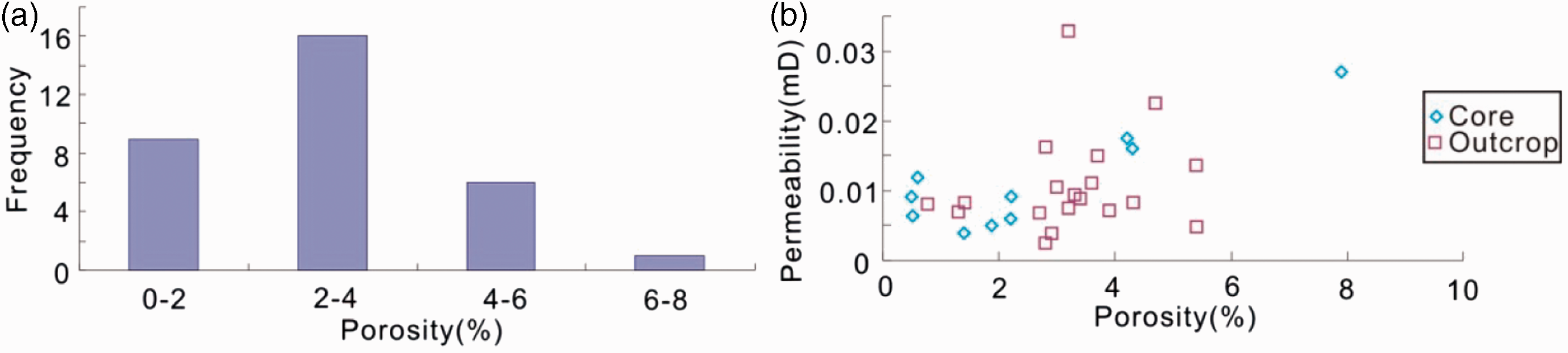
The average porosity in productive areas of the Barnett shale ranges from 3 to 6%, whereas in nonproductive areas porosity is as low as 1%. Average matrix permeability has been reported to be 0.02–0.10 mD (Jarvie et al., 2007), less than 0.01 mD (Montgomery et al., 2005) or in the range of microdarcy to nanodarcy (Bowker, 2007). For the Marcellus shale, the average porosity is from 6 to 10% (Arthur et al., 2008; Wrightstone, 2008). Engelder (2008) reported permeability values of the Marcellus shale ranging from 200 to 400 nD and Hill et al. (2007) cited values of 4–216 μD.
The Longmaxi shale in southeastern Chongqing and the Barnett shale are practically identical in terms of basic reservoir properties. Porosity for both shales is below 6% and permeability is measured in microdarcies to nanodarcies. The Marcellus shale has a higher porosity than the other two shales, but the permeability is similar to the Longmaxi and Barnett shales. Permeability in the shales is complex and depends on the local interplay of the fractures, faults and stress regime.
Mineral components
The composition of the shales consists of detrital minerals (quartz, feldspar, etc.), authigenic minerals (calcite, dolomite and pyrite, etc.), clay minerals (illite, smectite, kaolinite and chlorite, etc.) and a minor organic matter (Liu, 1980).
Mineral components of shales in well YY-1 and outcrops.
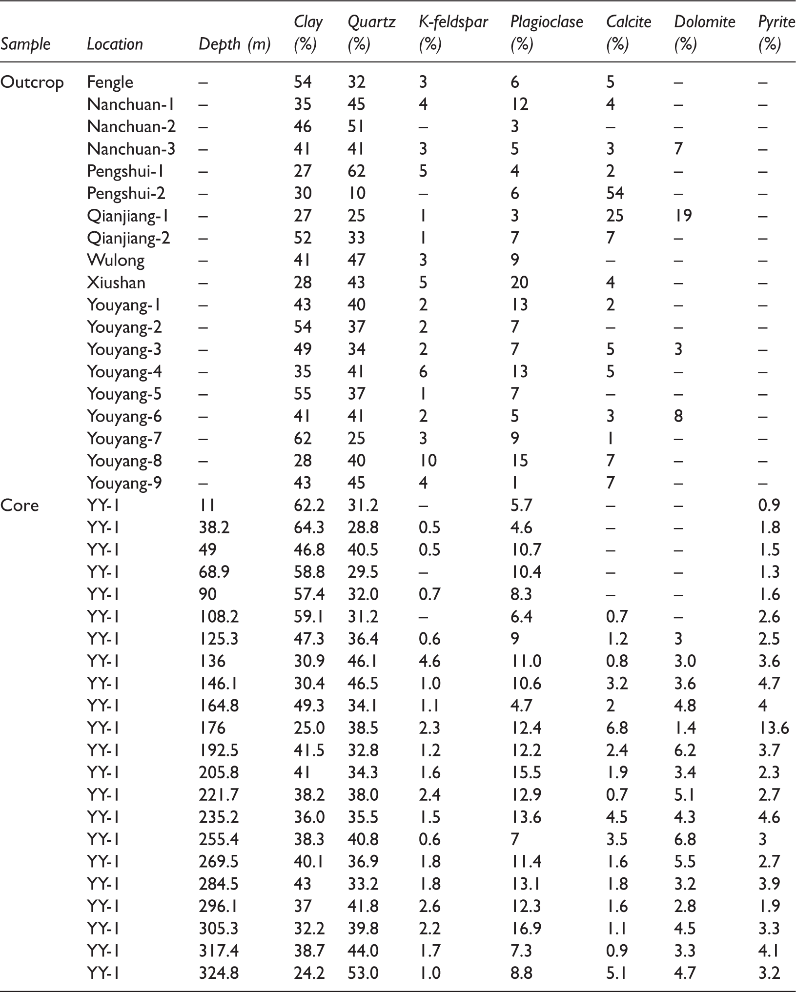
Analysis of clay components indicates that clay in shales from outcrop consists of illite, illite-smectite-mixed layer (I/S) and minor chlorite (Figure 9). Illite content varies from 44 to 81% with an average of 57%. I/S content varies from 17 to 41% (mean 26%). Chlorite content ranges from 2 to 23% (average of 14%). The Longmaxi shale has experienced early subsidence and later uplift, which can result in the conversion of smectite into illite in the diagenetic process.
Compositions of clay in outcrop shale samples from the study area.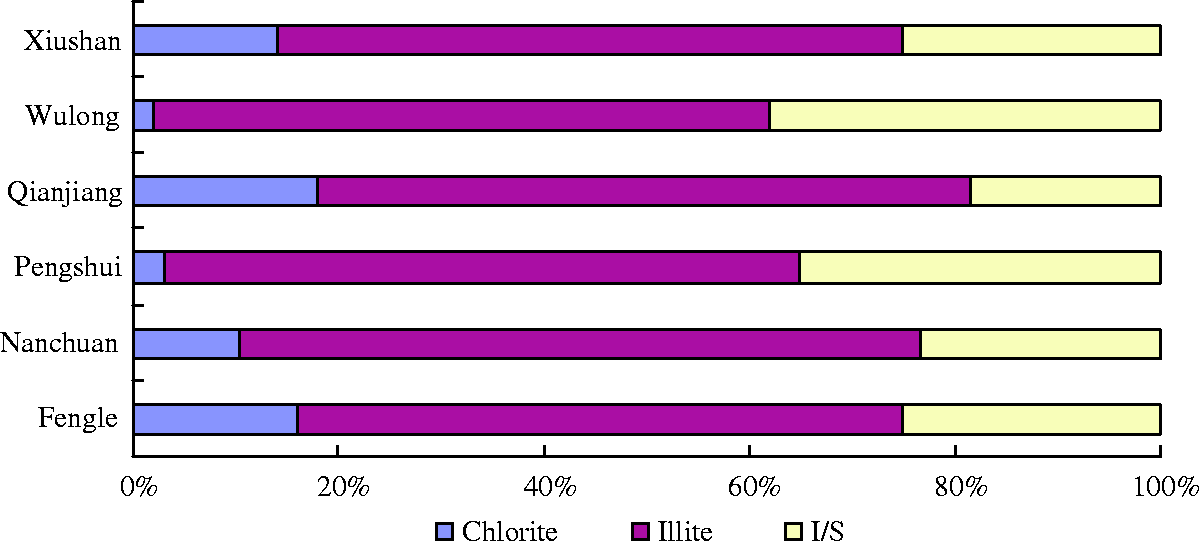
For the Barnett and Marcellus shales, respectively, quartz contents are 35–50% and 10–60%; clay (primarily illite) contents are 10–50% and 10–35%; pyrite contents are 5% and 5–13% (Bruner and Smosna, 2001). Both shales have high carbonate content due to the effect of underlying and interbedded limestone and have trace phosphate and gypsum which is not found in the Longmaxi Formation. Both the quartz and clay contents in the Longmaxi shales have a similarity to those in the Barnett and Marcellus shales; however, the carbonate is relatively lower.
The Barnett and Marcellus shales usually need hydraulic fracturing to produce commercial gas. Experience indicates that more than 50% fragile mineral is beneficial for hydraulic stimulation to propagate the microfractures for enhancement of permeability (Bowker, 2007). The fragile mineral content in the Longmaxi shale in the study area is mostly higher than 50% which should ensure successful hydraulic fracturing.
Sorption gas
Gas in shale reservoirs is stored in two principal states: free gas in natural fractures and interparticle porosity, and sorption gas on kerogen and clay particles (Curtis, 2002; Fan et al., 2014; Jarvie et al., 2007; Martini et al., 1998). Sorption gas content in place on cores from well YY-1 ranges from 1.0 to 4.5 m3/t based on the isothermal adsorption curves, and the content is a function of organic richness. Six outcrop samples on isothermal adsorption tests show that the sorption content in place on outcrop shales varies from 1.0 to 2.7 m3/t, which is slightly lower than that found in the core samples. And, as the pressure goes up, the sorption gas content increases (Figure 10).
Isothermal adsorption curves for the Longmaxi shales taken from outcrops (a) and cores in well YY-1 (b).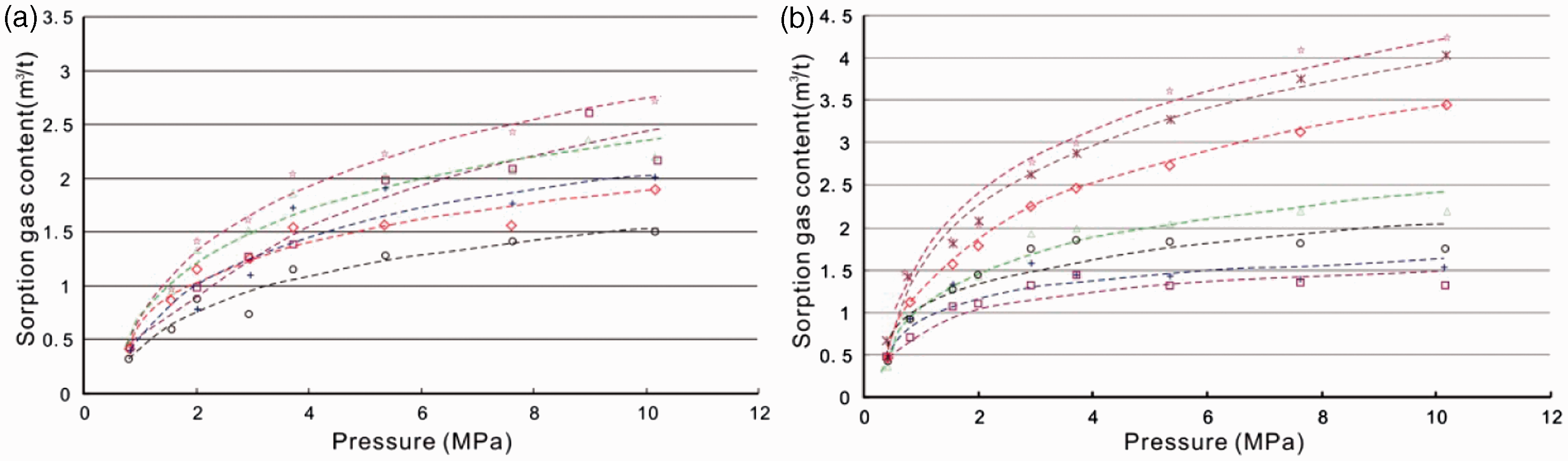
In the Fort Worth Basin, gas contents in place in the Barnett shales are 1.4 m3/t measured in well MEC 2 T. P. Sims and 3.3 m3/t in well 1 Mildred Atlas by Chevron (Martineau, 2007). Montgomery et al. (2005) demonstrated that the sorption gas in place content is 1.7–3.5 m3/t at a reservoir pressure of 0.18 MPa. Gas content in place in the Marcellus shale is currently estimated to range from 1.7 to 2.8 m3/t (Arthur et al., 2008). For the Barnett and Marcellus shales, gas adsorbed onto solid organic matter and kerogen is as low as 20–25% or as high as 40–60%.
The function of the sorption gas content in the Longmaxi shales and critical geological parameters such as TOC, Ro and clay content are analyzed using a mathematical statistic method (Figure 11). From the relationship between TOC and the sorption gas content, it can be seen that an approximate positive correlation exists for cores and outcrop samples, respectively (Figure 11(a)). Correlation coefficients R2 for those two Longmaxi shale samples are 0.7444 and 0.5651, respectively. So, TOC is one of the most important factors with respect to the sorption gas content.
The relationship of TOC content (a), Ro (b) and clay content (c) with the sorption gas content in the Longmaxi shales for well YY-1 and outcrop samples in the study area.
The thermal maturity between the outcrop shales and cores is different. However, the sorption gas content in place remains between 1 and 3 m3/t for a variety of Ro (Figure 11(b)). Therefore, the thermal maturity may be not a decisive factor for the sorption gas content in the Longmaxi shale in southeastern Chongqing.
As one of the important mineral compositions of shale, clay content may play a role in the adsorption of gas. In the Longmaxi Formation of the study area, the sorption gas content of shale cores increases slightly with an increase in clay content (Figure 11(c)). However, with respect to the outcrop samples, the relationship between the sorption gas content and clay content is not clear. This may be due to the effect of weathering on the outcrop shales.
Besides the TOC, Ro and clay content, other geological factors may also influence the sorption gas content, such as the types of kerogen, reservoir pressure, reservoir temperature, quartz content, porosity scale, specific surface area and so on.
Free gas
When the shale gas field is first in exploitation, the initial gas production comes from free gas that is accumulated in matrix pores, organic pores and fractures. Later, when the formation pressure drops, production begins to come from gas desorption from organic matter, clay particles and kerogen. Therefore, the free gas content in place and its proportion are critical because they can mostly determine whether the gas play is commercial or not.
For the Barnett shale, the free gas content in place is around 2.97 m3/t, and the total gas in place (free gas plus sorption gas) varies from 4.8 to 9.9 m3/t (Arthur et al., 2008; Montgomery et al., 2005). Reservoir modeling showed that, with a matrix porosity of 6% and pressure of 0.18 MPa, gas-storage capacity can be 4.5 m3/t or more (Jarvie et al., 2007).

Free gas content calculation based on petrophysics for well YY-1.
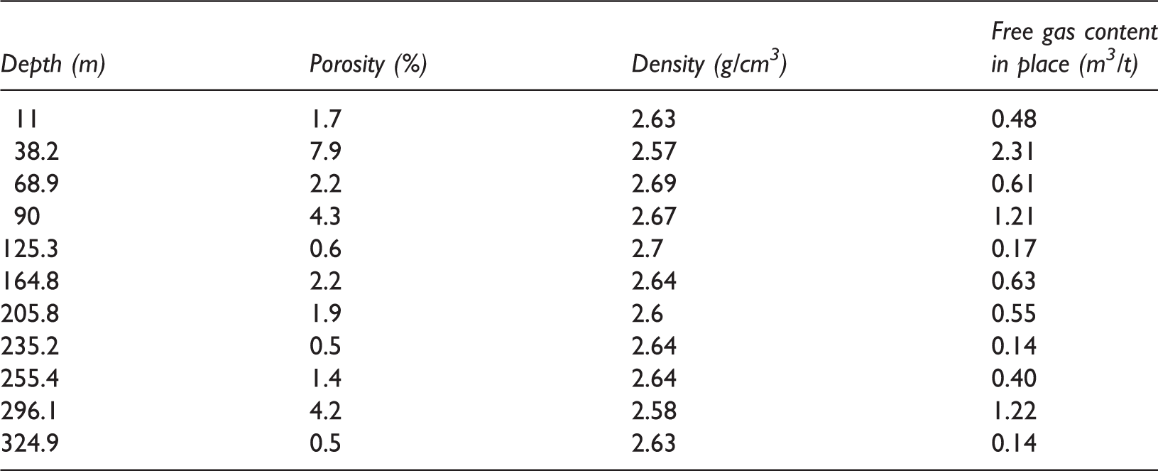
Content of free gas stored in fractures and pore space depends largely on the porosity. Mineral composition, hydrocarbon generation capacity, tectonic movement and preservation conditions are also the main factors influencing the free gas content.
Shale developed in the Longmaxi Formation in the study area has much geological similarity to the Barnett and Marcellus shales in the USA. Compared with those two successful shale plays, the Longmaxi shale is characterized by shallow burial depth and more complex evolution, which resulted in a high thermal maturity. Critical parameters such as TOC, mineral compositions and gas content are equivalent to the Barnett and Marcellus shales, which indicate that the Longmaxi Formation also has huge potential for shale gas accumulation.
The structural complexity found in the southeastern Chongqing area may be an adverse factor for shale gas preservation. Therefore, the preservation condition should be given more attention when it comes to shale gas exploitation here. Total gas content of the Longmaxi shale in place varies from 1 to 5 m3/t.
Conclusions
Based on the analysis of the shale characteristics, gas content and factors influencing gas content in southeastern Chongqing, the following statements are concluded.
The Longmaxi Formation in the southeastern Chongqing area experienced strong tectonic movements resulting in shale uplift and partial erosion. The Longmaxi shale is characterized by shallow burial depth and abundant fractures. Abundant pyrite along with graptolite fossils found in these shales indicates a shallow continental shelf along with deep sea argillaceous slope sedimentary environments. The lithology of the Longmaxi shales includes black carbonaceous shale, calcareous shale, and siliceous shale, with grain coarsening upward throughout the formation. The thickness of the shale varies greatly from 40 to 200 m from southeast to northwest with obvious zonation. TOC content in the Longmaxi shale cores mostly ranges from 2 to 4% while in outcrop samples it is relatively low because of the weathering. The organic matter reaches mature and post mature stage. The porosity ranges from 0.5 to 7.9% for shale core and 0.77 to 5.40% for outcrop samples. Permeability measured is in microdarcy to nanodarcy scale. Average of the fragile mineral content in the Longmaxi shales is over 50%, which would benefit the hydraulic simulation. Most geological factors are similar to the Barnett and Marcellus shales, indicating favored conditions for shale gas accumulation. Isothermal adsorption tests show the sorption gas content in place ranges from 1.0 to 4.5 m3/t for shale cores from well YY-1 and 1-2.7 m3/t for outcrop samples. Calculated free gas content in place varies from 0.1 to 2.3 m3/t. In addition, critical geological factors impacting gas-bearing characteristics are analyzed by using mathematical statistic method. It demonstrates that the TOC is the most important factor, especially for the sorption gas content.
Footnotes
Acknowledgements
We also thank Ramsey Bentley, Jiao Zunsheng from the University of Wyoming, and Dr Li Junqian from the China University of Petroleum for polishing the manuscript. Many pictures of the shale outcrops were offered by colleagues from the China University of Geosciences, for which we are very appreciative.
Declaration of conflicting interests
The author(s) declared no potential conflicts of interest with respect to the research, authorship, and/or publication of this article.
Funding
The author(s) disclosed receipt of the following financial support for the research, authorship, and/or publication of this article: This research was supported by China Huaneng Group science and technology project (Main factors on induced fracture characteristics for shale formation in Youyang East area) and Huneng Clean Energy Research Institute programme (The study on reservoir characteristics description for Longmaxi shale in Qianjiang area).