
Abstract
The world’s present coastal land use is unsustainable in the face of sea level rise and storm surges induced by climate change. This is true of urban, suburban, and—to some degree—recreational use of coastal land, but it is especially true of the urban infrastructure that serves our economic activities and livelihoods. Hurricane Sandy was only one example of what the future holds; such events will occur with greater frequency and severity as the level of the ocean rises as much as 6 feet by the end of this century. Therefore, architects, engineers, designers, urban planners, developers, infrastructure operators, and decision makers in the private and public sectors must start planning now the best ways to minimize the increased flood hazards that threaten the built environment. Using New York City as a case study, this article delves into the major competing approaches: defending against flood and rising waters with massive earthworks and expensive engineered structures; accommodating to and living with the rising waters so that the city can recover quickly after flooding; strategically relocating to higher ground; and spreading the risk via insurance. It also examines two other options: doing nothing, and stopping the flooding problem at its source.
When Hurricane Sandy struck the northeast coast of the United States in October 2012, 43 people in New York City died; 6,500 patients had to be evacuated from hospitals and nursing homes; nearly 2 million people went without power for days; 1.1 million children were unable to attend school for a week; nearly 90,000 buildings flooded with water; and the daily travel of about 11 million commuters was disrupted (Special Initiative for Rebuilding and Resiliency (SIRR), 2013). Insurers say that the Big Apple suffered $19 billion in damages (SIRR, 2013: 6), and insurers say the total loss was $65 billion, of which $30 billion were insured losses (Munich Re, 2013: 65).
One reason that Sandy’s impact on New York City was more severe than prior storms was because the storm flooded a large portion of the subway system, leading to its total shutdown. This was the first time this had happened since subways first started to operate in New York, in 1904.
Future Sandy-like losses will be amplified by additional risk factors, including climate-induced sea level rise; more frequent and intense storm surges; and insufficient mitigation and adaptation efforts, among others. As a result, the likelihood of the recurrence of extreme events and losses will increase at least tenfold before the end of the 21st century. They will bring similar effects upon all the various other parts of the city’s infrastructure, such as road and rail tunnels; rail lines; airports; seaports; sewage treatment plants; electric, gas, and telecommunication facilities; and industrial plants. So, what are the options to adapt to these new conditions, given the physical assets New Yorkers inherited and the vulnerabilities of those assets?
The past 400 years: A lucky time to build
In the time since Peter Minuit purchased the island of “Mannahatta,” this deepwater Atlantic port city grew fast, thanks to human-made structures such as canals, ferries, railroads, streetlights, sewers, skyscrapers, trollies, the electrical grid, subways, airports, and superhighways. Engineers built more than 2,000 bridges and tunnels to stitch Manhattan and the city’s other four boroughs to the rest of the country, which meant that New York City was no longer a series of islands dangling off the coast of the North American continent. To supply water, a series of massive reservoirs, controlled lakes, and aqueducts were built as part of a complex, gravity-fed system that rivaled that of ancient Rome; it drew upon a watershed encompassing 2,000 square miles, roughly the size of the state of Delaware (New York City Department of Environmental Protection (NYC DEP), 2013). Impressive parks were created in the very center of the city that were open to the public—a novelty at a time when many parks were still private preserves guarded by lock and key. Robert Moses later cut roadways through established neighborhoods and built automobile parkways to the beaches and parks. Suburbia followed on the heels of this newfound mobility, and second-home beachfront communities sprang up hard by the sands of the ocean. Over time, many of these became primary residences.
Our predecessors were lucky to be building all this infrastructure at a time in history when the sea level changed very little. Assets that had been built on the waterfront centuries earlier were hardly more prone to flooding a hundred years later, although they occasionally were threatened by storms. The original waterfront elevations for our coastal assets stayed more or less safe during their lifetimes.
That is now changing.
The forecast rise in sea level and the increasing size and frequency of storm surges requires society to forge an entirely new relation to the waterfront. In fact, even the term “front” is part of the problem, as it implies that we stay put. That attitude will not fly in the near future. We must adapt to the rising sea ingeniously and expeditiously. We need to thoroughly comprehend the new climate reality if we want to pursue livelihoods near the ocean, its estuaries, and its tidal-river inland extensions.
Given that in only four centuries the coastal landscape and the cityscape have undergone multiple, radical transformations, we should expect even more change in future centuries—and at a time when the ocean will encroach ever more rapidly on existing settlements, infrastructure, and livelihoods. We have no choice but to plan for a new life upon changing shores and sea levels. These challenges can become opportunities for urban renewal, but only if we quantify and account for the climate-driven changes.
To help prepare, in 1988 the United Nations formed the Intergovernmental Panel on Climate Change (IPCC) to provide global projections every five years of the changing climate; these projections look decades into the future. Similarly, the New York City Panel on Climate Change (NPCC), appointed by the city’s mayor in 2008, looks at climate forecasts affecting the greater New York City metropolitan region, especially sea level rise. (While other climate-induced risks are considerable—including extreme heat, precipitation, and windstorms, to name a few examples (NPCC, 2015; SIRR, 2013)—this article focuses on sea level rise and coastal storm risks only.)
In 2015, the NPCC projected the sea level rise for the mid-2020s, -2050s, -2080s, and for 2100. These projections were calculated relative to the 2000–2004 average sea level, at varying levels of confidence. At the 90th-percentile level—in other words, the level where 90 percent of the multiple forecasts from different teams using different methods fall below it—the ocean is forecast to rise 10 inches by the middle of the decade of the 2020s, 30 inches by the mid-2050s, 58 inches by the 2080s, and 75 inches (more than 6 feet) by the end of the century.
Those who operate New York City’s infrastructure opted, under the guidance of the mayor’s office, to adopt this 90th-percentile forecast as the fundamental basis for planning any adaptation to sea level rise. Choosing these figures has the advantage that if the sea level rises more slowly than anticipated, then any given critical elevation will be reached later, thereby increasing the safety margin.
Buying into safety is rarely a wasted investment when the hazard persistently increases, as is the case with sea level rise, and previously once-in-a-lifetime events become nearly commonplace. The kind of flooding that occurred during Hurricane Sandy in 2012 is presently considered to be the sort of event that happens only approximately once every 700 years—or, more accurately, a flood with an annual chance of one in 700. But before the year 2100, a Sandy-like flood will occur, on average, once every 10 years (or an annual chance of 1 in 10). That is a 70-fold increase in annual probability!
But what are the implications of this increased risk of flooding on New York City’s infrastructure—the basic, physical, underlying framework that is essential to the functioning of any city? For that matter, what does an increase in risk mean?
Time-dependent hazards and risks, and flexible adaptation pathways
In the climate-science and risk-assessment professions, Hurricane Sandy and its impacts were long expected (ClimAID, 2011). But the public ignored these assessments, as did most policy-making institutions. Sandy provided an opportunity to change this, but while some incremental changes to reduce risk are under way, we are still in denial of the long-term consequences of sea level rise. A rational approach would look as follows.
First, we need a quantitative grasp on the current coastal storm flood risks; then we seek to understand how these risks grow with climate change and sea level rise. In short, we need science-based, forward-looking, quantitative risk assessment as a sound foundation on which not just to rebuild but to proactively build, or what those in our professions call “probuild.” As a society, we cannot simply be reacting to adverse events, but must prepare in advance.
Second, we need to get on the table the full range of available options to manage the risks. Understanding the costs and benefits of pursuing various adaptation choices is essential to choosing the best pathway to a more resilient and sustainable future.
And third, we must muster the political will—and set aside the financing—to translate any adaptive vision into policies, laws, zonings, codes, and other regulatory tools. This means that we need to understand that whatever storm resiliency we develop to be optimal at this time may not be optimal for future sea levels. Resilience that is only short-term can become a liability for our children’s children. Present affordability needs to be balanced against intergenerational equity. We must strive for sustainable resilience, which may come at initially higher costs. But not taking prudent action will be more costly—if not now, then later.
All of which comes down to the element of risk.
What is risk?
Risk is the potential for future losses in a given region. Risk can be defined as the probability of something bad happening (the hazard), times the magnitude of its consequence (the impacts). Another way to put this: Risk is equal to the probability of the hazard (for example, from the data on a flood zone map) multiplied by the asset value (from a city’s tax map) times the vulnerability of the asset (determined by building codes and engineering standards). One can depict the interplay of risk factors in a simple diagram (see Figure 1).
Risk and its three constituent components: Hazard, exposure and vulnerability.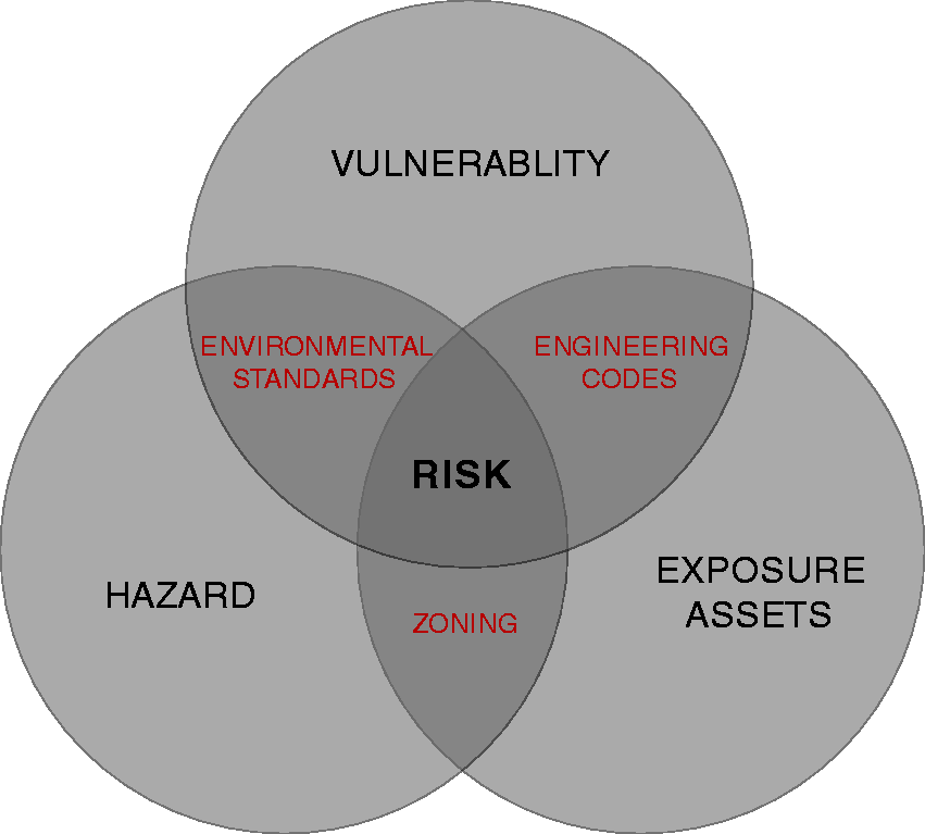
Managing risks
What cannot be measured cannot be managed. Now that we have learned how to measure risk, can we proceed to manage it? The task is to minimize the risk, which can be done by trying to minimize combinations of risk factors—that is, reduce the overlap of the circles in Figure 1.
Combining hazards, exposure, land use, urban planning, and zoning determines where we place our public and private assets with respect to the spatial distribution of flood hazards. We can place assets inside flood zones or outside. So, for example, we can choose to build a beach house below the high-tide mark and see it flood every day. Or we can build on high ground.
Combining assets, vulnerability, building codes, and engineering standards can reduce the physical vulnerability of built assets, and therefore the risk. And then there is the social vulnerability or resilience of communities. This is much more complex, and requires directed and sustained policies to improve the capacity of communities to avoid, cope with, or recover from losses.
And we can set environmental standards for hazardous regions; they may regulate what impacts we are willing to tolerate in, or exclude from, certain areas.
Basic adaptation options
A major task in coastal and estuarine regions is to minimize the storm flood risks that threaten the built environment, the economy, and the quality of life of communities. Of course these communities may be facing other economic, social, or environmental stresses as well, which means that sometimes the measures we take to reduce coastal flood risks can also be a partial answer to these other stresses. There are five basic categories of adaptation.
Any of these options can be applied to individual properties, groups of properties, entire neighborhoods, or an entire region. All carry consequences for the safety and sense of community, its social fabric, and social resilience. These five modes of adaptation can be used in combination at any given time, or staggered over periods of time. All but the last require leadership, vision, political will, financial resources, planning, and engineering talent. They also require consensus based on social equity and fairness, public discourse, and a sense of buying in to the solutions.
Here are the pros and cons of the basic five adaptation options:
Protect and defend
On a grand scale, some proposals have been put forward to protect at least part of the coasts, harbors, and estuaries by major barrier systems, much like the elaborate and ingenious dikes and waterworks of the Netherlands; the Thames Barrier that protects London; or the protective barrier/levee/pumping systems of New Orleans. These projects can be costly: The flood barrier project designed to “save” Venice from disappearing beneath the rising waves is expected to cost about $6 billion (Windsor, 2015). But such engineering mega-projects can be worth it, when one considers that Katrina caused losses on the order of $100 billion, while post-Katrina upgrades cost only $15 billion (Schleifstein, 2013). The problem is not the price, but the unsustainable effectiveness of such structures, their jurisdictional complexities, and whether their maintenance can be guaranteed as sea level rise continues to accelerate. Any solution is expensive, but accommodation and strategic retreat has a chance of lasting for some time.
Estimates for barriers to protect New York City are in the range of $20 billion (Associated Press, 2013) but they may pay for themselves after just a single repeat of Sandy. At least one of the flood control projects—New Orleans—serves as an example of failure, because it was devastated by Hurricane Katrina due to poor maintenance and a lack of upgrades. New York City’s plan (SIRR, 2013) does not propose such regional protection and in fact makes a strong case against it.
Most of these quite large, regional protective systems were conceived, designed, and built at a time when our understanding of climate change, greenhouse gas emissions, and sea level rise was either nonexistent, emerging, or ignored; any adaptive improvements and upkeep were left to future generations. The Netherlands is rethinking its past approach of relying largely on engineered hard structures, and instead looking to work more with the water and the country’s natural resources to find an affordable pathway to a sustainably resilient future.
Why are storm barrier systems problematic? In addition to their high up-front cost, barrier systems need to be kept open most of the time—except when storms approach, when they are closed to keep the high waters out. But when sea level rises to heights comparable to levels reached now by Sandy-like storm surges (say, 6 to 8 feet on top of whatever the high tide may be), then the barriers will need to be closed permanently to prevent permanent inundations. But then the Hudson and the Raritan Rivers can’t discharge into the Atlantic, and you get flooded from behind the barriers. Theoretically, you could pump the rivers “up” to the ocean; or you could guide the rivers out by canals, lined with levees behind and below which the cities would be walled off from the channeled rivers. Cartoonists have caught the essence satirically, but it actually looks much like what visitors to Amsterdam see in explanatory posters and street-side plaques. For example, when travelers fly into Amsterdam’s Schiphol Airport, they may be surprised to learn that the runways are 4.5 meters (nearly 15 feet) below mean sea level—which means that much of their plane would be under water should the nearby dikes ever fail (Schiphol Group, 2015).
This is essentially the current solution at the mouth of the Mississippi River, where one can sometimes see barges going by above the land. But its long-term sustainability in the face of open-ended sea level rise is unknown. Some, including me, think it is unsustainable.
Protection and defense against rising seas and storm floods has been proposed for some parts of New York City (SIRR, 2013) using temporary, removable floodwalls and on a mid-term basis by using barriers at such locations as the entrance to the mouth of the Newtown Creek that marks the border between Queens and Brooklyn, and at the Gowanus Canal in Brooklyn. A levee system named “Big U” has been proposed for Lower Manhattan as part of a new development plan; it has been promoted as being able to protect low-lying, vulnerable neighborhoods, public housing, and even major business buildings near the Wall Street area. The city of Hoboken, New Jersey, has put forward plans that include protective structures at both the northern and southern entry points of waters from the Hudson River. Pumping rain and seeping water out of the low-lying areas is a challenge in all of these cases. While all these projects are to some degree feasible and potentially effective for decades to come, their long-term sustainability is questionable, at best.
Accommodation
This mode of adaptation to rising waters essentially tries to invite—and live with—water, rather than keep it out. For an individual building, the Federal Emergency Management Agency (FEMA) would call for “wet proofing,” which requires all critical electric, water, heating, air conditioning, and other systems to be put on higher floors. Materials should be used that can be submerged at least temporarily, so that only a cleanup is needed after the flood to get back in business very quickly. On an urban scale, accommodation may mean “high lines” that connect major business buildings above the normal street level, initially perhaps only for pedestrians and bicycles, later to be extended to small vehicular traffic such as self-guided vehicles, trolleys, monorail and levitated trains, or regular elevated transit systems. (Admittedly, it would be ironic if the city were to bring back the El after going to so much trouble and expense to remove most of the structures.) The streets below can be flooded; the utility systems would need to become submersible, and delivery and retrieval of mass goods, including solid waste, would gradually shift to barges.
A modern Venice or Amsterdam on the Hudson! But Hafen City in Hamburg, Germany, does provide a model for accommodation—blended with elements of defense—that has been scaled up to a full-fledged new urban design (HafenCity Hamburg: www.hafencity.com/en/home.html).
Meanwhile, in the Netherlands, floating houses and buildings have become another way to sustainably accommodate to rising waters. There is no finite time horizon for this solution, although it does make demands on new designs and codes for flexible service connections to such new habitats. All transportation would be largely waterborne. Except for the floating structures, any of these accommodation measures could only work for a fixed period of time, as they are pegged to certain water elevations, and hence would need to be upgraded periodically.
There is, however, little chance of using accommodation options for subway, road and rail tunnels, and other low-lying transportation systems. Options are to either seal them off just during storms with well-engineered gates, or raise their entrances—that is, re-engineer them as if the rivers, under which subways have run successfully for a century, have become wider and deeper.
Strategic relocation
This is a political hot potato, internationally, nationally, and locally. Climate-forced relocation is already happening in small Pacific and Indian Ocean island nations; they have no choice.
Similarly, smart money is likely to find out sooner or later that any high ground in the city is safer and more valuable real estate than unsafe waterfronts.
New York City has several of these high geographic regions, historically called “heights,” such as Brooklyn Heights, Washington Heights, and Morningside Heights. Over time, some of the established waterfront real estate will turn into public parks and other flood-tolerant uses.
As for the low-lying areas, many of these coastal and estuarine communities are destined to be permanently inundated, in some cases before the end of this century. (Miami and other Florida communities will be threatened with little or no high ground to retreat to.) Real estate prices and the tax base will inevitably decline in such areas.
Yet, generally, we currently have few public policies in place to address the inevitable inland migration. Most communities and cities, including New York City, are more or less in “risk denial” regarding this long-term threat. Options to deal with it include rezoning high-elevation, low-density neighborhoods so that they can accommodate more people and higher buildings. Cities could use the income from selling such new higher-density development rights to buy out low-lying coastal properties. We need to think of major federal, state, local, and private programs for setting up trust funds and revenue streams (for example, a tax on carbon) that help families, neighborhoods, and entire communities to be bought out. With this in mind, the New York State post-Sandy buyout program of several hundred houses in the Oakwood Beach community on Staten Island will be watched as a critical pilot program.
Raising of houses, where technically possible, is a temporary option, because it only delays the inevitable in the long run. And in urban settings with attached housing or large units, such raising is not feasible or even possible. There, converting lower floors or subgrade basements into usages that allow for flooding and then cleaning up may provide some partial and temporary relief for the loss of regular rentable space. Clearly, innovative urban planners and designers will have a future. But we must allow them to be visionary, by developing and implementing policies that foster rezoning and allow retreat and relocation away from threatened coasts and estuaries. This will likely soon become a pressing issue for both the private and public sector.
Insurance
One way to distribute risk is via insurance, a proven instrument of risk management. But it works best when the risks, or their loss-causing events, are uncorrelated and statistically random, like car accidents or death rates in a given population. Insurers need data on the statistics to make reliable forecasts and set realistic premium prices to cover the risk they take on from many customers. The price to the customer must be affordable.
The private insurance industry has walked away from insuring flood risks for decades, except for specialty cases that carry high premiums, such as flood-related business interruption, because the criteria are not met for catastrophic extreme weather events— flooding in particular. That is why the call for an affordable national flood insurance program became a political priority many decades ago. Developers and bankers were unable to do business or provide mortgages without such insurance. But the public fell into a pattern of behavior, known among insurers as “moral hazard,” in which the insured take reckless risks of development in flood-prone areas, because insurance will cover at least some of the risks. As the nationally insured flood-risk assets grew, the National Flood Insurance Program became unsustainable at affordable prices; the program is currently in the red by more than $20 billion.
In 2012, before Hurricane Sandy, Congress passed an insurance reform act that was to adjust the premiums upward to get the flood insurance program on a sound financial footing. But Congress revoked most of its provisions in 2014, under public outcry that the premiums had become unaffordable. Eventually FEMA flood insurance premiums will become, due to continued sea level rise, unaffordable to house owners in coastal regions, yet those having mortgages must have flood insurance.
The writing is on the wall. The nation’s citizens have long enjoyed the benefits of using fossil fuel at unrealistically low prices and flood insurance at rates that in most coastal regions do not reflect the real risks. We thought we had a free ride. The National Flood Insurance Program prolonged development in coastal flood zones and along estuarine rivers, instead of discouraging, foreshortening, or outlawing such ill-posed developments. We are procrastinating in regulating coastal development, while sea level keeps rising. This is unsustainable, and insurance cannot fix this issue, which is deeply imbedded in our ill-conceived past and still continuing coastal land use and development policies.
Do-nothing option; or business as usual
It is clear that non-adaptation is not an option—at least not without bitter consequences in times to come. The sooner we awake from our risk denial, both on climate mitigation and adaptation, the better off we are. This is a challenge as much as an opportunity. From some careful study (National Institute of Building Sciences (NIBS), 2005), mandated by Congress a decade ago, it emerged that for every dollar spent on disaster risk mitigation and resiliency, we earn an average of four dollars by avoiding losses. As a nation that prides itself on making smart investments to achieve a better future, this is one of the best-kept investment secrets. It’s time that it became public knowledge, and used prudently.
Recommendations
National to regional sea level rise projections for this century are in the range of several feet, with a 6-foot forecast at the 90th-percentile level of confidence by the year 2100 for the greater New York metropolitan region. These forecasts are above the IPCC (2013) forecasts made for global sea level rise. Sea level rise in the order of tens of feet will continue in centuries to follow (IPCC, 2013). As pointed out in a recent National Academy of Sciences Report (National Research Council (NRC), 2013), more surprises may be in store, induced by abrupt climate change impacts. According to this report, “a large part of the West Antarctic Ice Sheet (WAIS), representing 3-4 m [9 to 12 feet] of potential sea-level rise, is capable of flowing rapidly into deep ocean basins” (NRC, 2013: 6). Therefore, it is possible that rates of sea level rise in this century alone can exceed the national or regional forecasts. The National Academy of Sciences committee of scientists judged, very cautiously, “an abrupt change in the West Antarctic ice sheet within this century to be plausible, with an unknown, although probably low probability” (NRC, 2013: 6).
Engineered options to protect against sea level rise and storm surges are likely to be effective only for limited times—perhaps a century or two, in some cases. Similarly, engineers, urban planners, and designers may find solutions that are viable for a century or so to protect densely settled communities along coasts from storm surge flooding and permanent inundation from sea level rise.
But even with innovative urban designs and advanced engineering solutions for our cities and their infrastructure, such protective measures appear to be unsustainable for future centuries, unless we find ways to geoengineer the Earth’s climate back to its pre-industrial state. We can slow down the rate of climate change and sea level rise by tapping into renewable energy sources and hence first reduce, and then eventually nearly avoid, greenhouse gas emissions. We can make attempts to create, preserve, and maintain global carbon sinks. But unless such efforts lead to timely success, the strategic relocation of entire populations to higher ground will become a global necessity that in some regions will lead to political and social instabilities.
Multiple time horizons need to be considered to arrive at intergenerationally fair, affordable solutions towards sustainable resiliency. The tendency to deny current coastal flood risks and future rising risks due to sea level rise must be overcome. We must use the best available scientific, technical, and socioeconomic data and methods to inform a proactive instead of a reactive political process. Sustainable resiliency, climate change adaptation, and mitigation must become core principles of our collective behavior. To achieve this transformation, we need to find ways to combine climate-specific objectives with other opportunities that improve the broader social and economic state of our cities, communities, and livelihoods for generations to come, regardless of climate change.
Footnotes
Acknowledgements
The author is grateful for insights gained during his activities as a member of the New York City Panel on Climate Change and the research group advising the post-Hurricane Sandy Rebuild by Design competition, underwritten by the Department of Housing and Urban Development together with the Rockefeller Foundation.
Funding
This research received no specific grant from any funding agency in the public, commercial, or not-for-profit sectors.