
Abstract
Biodiversity hotspots are biologically rich yet highly threatened regions that play a critical role in global conservation but often serve as epicentres of human–wildlife conflict (HWC). HWC poses major conservation and development challenges, undermining both human livelihoods and wildlife protection efforts. Artificial intelligence (AI) offers transformative tools for mitigating HWC by enhancing monitoring, prediction, and decision support. Through systematic searches of peer-reviewed and grey literature, this review analyzed 105 studies (1990–2025) from 163 screened sources, revealing that AI improved HWC monitoring (65%), predictive accuracy (47%), and community engagement (39%). AI-driven technologies such as machine learning, deep learning, and computer vision enable conservationists to process large datasets, automate species identification, and make real-time decisions. Integrated platforms like Earth Ranger and the Spatial Monitoring and Reporting Tool (SMART) use AI to manage data from rangers, camera traps, drones, and patrol logs, providing situational awareness and strategic planning tools. Furthermore, remote sensing, Geographic Information Systems (GIS), and participatory data integration offer multi-layered insights for mapping HWC zones, tracking wildlife movement, and modelling species distribution. This review highlights the application of AI in conflict detection, community engagement, and decision support while addressing challenges, limitations, and ethical concerns. It also underscores the importance of policies and future research to integrate AI with local knowledge systems, participatory governance, and adaptive conservation strategies. Overall, AI advancements are transforming HWC surveillance and enabling more proactive, equitable, and sustainable biodiversity conservation efforts worldwide.
Introduction
Biodiversity hotspots are biologically rich yet highly threatened areas that play a critical role in global conservation.1,2 Norman Myers pioneered the concept in the 1980s and later expanded by Conservation International to include 36 regions globally.2,3 To qualify as a hotspot, a region must have at least 1500 endemic plant species and must have lost at least 70% of its original habitat.2,3 These hotspots include regions, for example, the Eastern Afromontane, Indo–Burma, Sundaland, Madagascar, the Indian Ocean Islands, the Western Ghats, and Sri Lanka (Figure 1). Although they occupy only 2.3% of Earth's land surface, they are home to over 50% of the world's endemic plant species and 42% of terrestrial vertebrates.3–5 Hotspots are not only crucial for protecting biodiversity but also provide essential ecosystem services, for instance, carbon sequestration, water purification, and climate regulation.6–8 Despite their ecological importance, biodiversity hotspots are under intense pressure from land conversion, infrastructure development, illegal wildlife trade, logging, and agriculture.1,9 These anthropogenic activities not only degrade ecosystems 10 but also bring humans and wildlife into closer contact, often resulting in human–wildlife conflict (HWC).11–13

World map showing biodiversity hotspots.
Local threats to biodiversity hotspots are increasingly driven by land-use change, illegal exploitation of wildlife, and expanding infrastructure, all of which accelerate habitat fragmentation and species decline. In the Eastern Afromontane and Albertine Rift regions, agricultural expansion particularly for smallholder farms remains a dominant cause of deforestation and ecosystem degradation.14–16 In southeast Asia, illegal wildlife trade, fuelled by global demand and weak enforcement, continues to decimate populations of pangolins, tigers, and other threatened species.17,18 Infrastructure projects such as roads and dams in the Himalayas and Amazon Basin contribute to forest loss and disrupt migratory corridors essential for ecological integrity. 19 These localized pressures, often exacerbated by socio-political instability and poverty, demand context-specific conservation approaches that integrate ecological science, community engagement, and adaptive policy frameworks. Emerging technologies like artificial intelligence (AI) is capable of performing this integration and support biodiversity hotspot conservation by enabling real-time monitoring of land-use changes, detecting illegal wildlife trade patterns, and optimizing conservation planning through predictive modelling of species distribution and habitat loss. 20
Biodiversity hotspots have traditionally garnered significant conservation focus due to their high species richness and endemism; however, biodiversity coldspots, which are regions marked by lower levels of species diversity yet possessing ecological significance are often underrepresented in discussions surrounding conservation strategies. These coldspots, prevalent in arid, alpine, or heavily modified landscapes, may not meet the conventional criteria for biodiversity hotspots but play crucial roles in sustaining unique ecosystems and providing vital ecosystem services.21,22 The essential functions of coldspots include supporting biological processes and offering services such as carbon storage and water purification, which are critical for human well-being and ecological health. 23 HWC in biodiversity coldspots can be as severe as those found in biodiversity hotspots, indicating that coldspots also face significant challenges relating to wildlife management. 24 Socio-economic circumstances in these regions further complicate conservation efforts; communities often lack the resources necessary for adaptive strategies that promote coexistence with wildlife, exacerbating tensions. 25 Additionally, addressing the ecological and social dynamics present in coldspots is essential for achieving effective conservation outcomes, as failure to do so could lead to the degradation of both biodiversity and ecosystem services. 26 Emerging technologies, particularly in AI, present promising avenues for addressing conservation challenges in these underrepresented areas. 27 In general, the integration of AI technologies in conservation efforts, especially in biodiversity hotspots, offers innovative solutions to mitigate HWC and promote sustainable ecosystem management. 20
This paper provides an overview of HWC in biodiversity hotspots, examining its drivers and impacts, as well as the role of AI tools in conservation, with a focus on conflict detection, community engagement, and decision support. It emphasizes the growing need for innovative, technology-driven interventions, particularly the contribution of AI in enhancing the management of biodiversity hotspots. The review explores how AI is applied in detecting and mitigating HWC, supporting community engagement, and strengthening decision-support systems. It also highlights the challenges, limitations, and ethical considerations associated with the use of AI in conservation. Furthermore, the paper discusses the role of policy, outlines future directions, identifies research needs, and acknowledges the study's limitations. Overall, the review aims to deepen understanding of how advancements in AI and rapid-response mechanisms are transforming HWC surveillance, enabling more proactive mitigation strategies, and strengthening global biodiversity conservation efforts.
Literature review method
As a narrative review, this work was guided by the Scale for the Assessment of Narrative Review Articles, a standardized framework that ensures quality, rigour, and transparency in review writing and reporting. 28 This narrative review employed a systematic approach to identify relevant literature on the application AI in mitigating HWC within biodiversity hotspots. Major academic databases, including Web of Science, Scopus, and Google Scholar, were searched for both peer-reviewed and grey literature published between 1990 and 2025. The search strategy used a combination of keywords and Boolean operators to capture relevant studies. Keywords included: ‘human–wildlife conflict’, ‘HWC’, ‘biodiversity hotspots’, ‘conservation’, ‘artificial intelligence’, ‘AI’, ‘machine learning’, ‘deep learning’, ‘computer vision’, ‘Earth Ranger’, and ‘SMART’. Searches were conducted iteratively, refining terms to ensure comprehensive coverage of relevant studies. Inclusion criteria required studies to focus on HWC in biodiversity-rich areas and report on the application of AI tools for monitoring, prediction, decision support, or community engagement. Both quantitative and qualitative studies, as well as grey literature, that is, reports and technical documents from conservation organizations, were considered. Studies that did not address HWC, biodiversity hotspots, or AI applications were excluded. From an initial pool of 163 studies, screening based on titles, abstracts, and full texts resulted in 105 studies that met the inclusion criteria.
HWC in biodiversity hotspots: drivers, impacts, and technological responses
In tropical regions like sub-Saharan Africa and southeast Asia, 29 deforestation for farming and settlement expansion increases the likelihood of HWC,29–31 which poses a severe challenge to biodiversity conservation.13,32,33 HWC often arise when wildlife, driven by habitat fragmentation, food scarcity, or seasonal movements, encroaches into human-dominated landscapes, leading to negative consequences for both humans and animals. 31 34–37 According to Nyhus, 13 the most significant underlying drivers of HWC in biodiversity hotspots include rapid human population growth and the resulting expansion of agriculture, intensified land and resource use, and increased development of technology, transportation, and energy infrastructure.
The ecological impacts are profound, particularly in biodiversity hotspots where species are already under pressure, including retaliatory killings. 38 Retaliatory killings in response to crop destruction or livestock predation often target keystone or endangered species, that is, elephants (Loxodonta africana), tigers (Panthera tigris), and lions (Panthera leo).34,35 These killings usually disrupt food chains and lead to population declines. 38 Additionally, physical barriers like fences can fragment habitats, limiting species movement and gene flow, impeding biodiversity hotpots.9,39 As a result of human pressure in biodiversity hotspots, the loss of apex predators and large herbivores may have cascading effects on ecosystem dynamics, 40 affecting prey populations, vegetation patterns, and biodiversity stability.40–42
Socio-economically, HWC threatens rural livelihoods.13,38,43 India and Nepal face acute HWC due to high human population densities near tiger and elephant habitats. 29 Farmers who live near protected areas or forest edges often suffer significant losses due to crop-raid by elephants, vervet monkey (Chlorocebus pygerythrus), baboons (Papio ursinus), wild pigs, and other different mammals. 11 43–45 In Kenya, for instance, a single elephant raid has been reported to destroy an entire season's harvest, pushing already vulnerable households into food insecurity.35,46 Similarly, livestock predation by hyenas (Crocuta crocuta), baboons, lions, and leopards (Panthera pardus) were reported to increase economic strain on pastoralist communities and provoked antagonism towards wildlife in several counties, including Tanzania.31,44,45 According to Dash et al. and Treves and Karanth, HWC can also cause significant psychological stress, as families live in constant fear for their safety or livelihoods. This stress often fuels opposition to conservation initiatives, creating tensions between local communities and wildlife managers or national park authorities.46,48 This implies that, without effective mitigation measures, HWC can undermine public support for conservation efforts and may even lead to increased poaching and illegal land use. 43 In some countries, HWC cases have been widely reported and are increasingly linked to human fatalities, particularly in biodiversity-rich regions (Table 1). Such incidents not only result in personal and community tragedies but also heighten tensions between local populations and conservation authorities. As a result, HWC contributes to the growing socio-political complexity of conservation, often undermining trust, cooperation, and long-term sustainability of protecting biodiversity hotspots.13,49
Some examples of HWC cases reported in different countries.

HWC: human–wildlife conflict.
As a result of persistent HWC, a range of conventional mitigation strategies have been implemented, including guard posts, chilli and beehive fences (Figure 2), compensation schemes, and the translocation of problem animals.12,58 While these methods have provided some short-term relief, they have generally achieved limited long-term success in reducing HWC. Many of these approaches are reactive, costly, or difficult to maintain, especially in remote or resource-constrained areas. Also, they often fail to address the root causes of HWC, that is, habitat loss, human population growth, and competition over resources. Besides, these interventions often lack real-time responsiveness and are not scalable. 47 Subsequently, there has been a growing need for innovative approaches that combine ecological insights with technological innovation that is, AI tools, to address HWC more effectively.59–61 With tools like machine learning, deep learning, and computer vision, conservationists can significantly reduce HWC and protect biodiversity hotspots. 27 62–64 This is because these AI tools can process large datasets, automate species identification, and make real-time decisions that were previously impossible.62,63,65
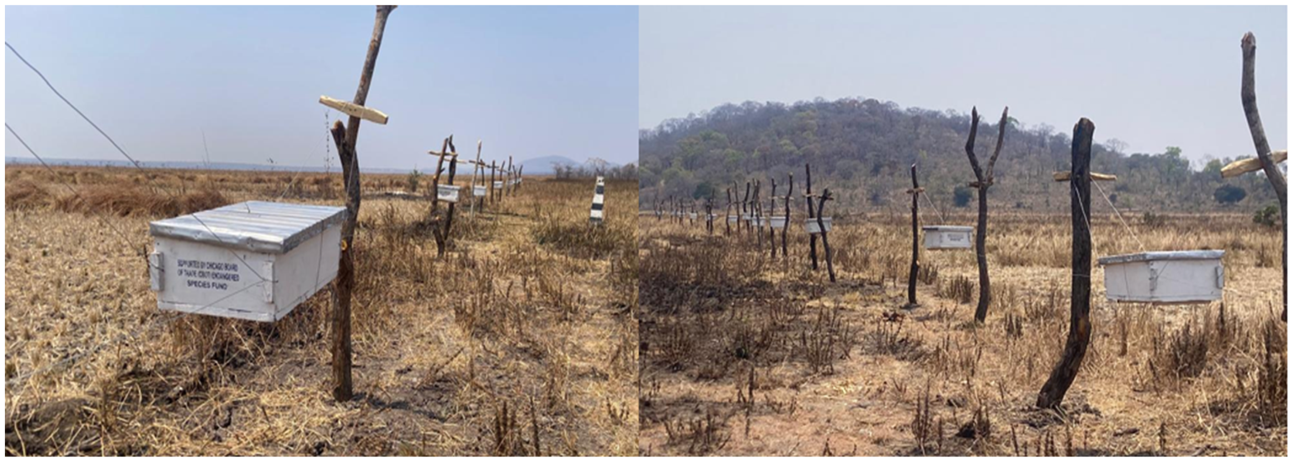
Examples of beehive fences installed in villages surrounding Katavi National Park to mitigate human–elephant conflict. This activity is part of ongoing project ‘Living alongside elephants: Human–elephant conflict mitigation and coexistence’ funded by The Chicago Board of Trade (CBOT) Endangered Species Fund (CBOT ESF) and Brookfield Zoo Chicago (BZC) in the United State of America (Photo: Fredrick Ojija).
An overview of AI tools in biodiversity conservation
The application of AI in conservation science provides innovative tools (Table 2) that are used in predicting wildlife movement, identifying areas prone to conflict, and enabling proactive measures to prevent HWC.29,66,67 These AI tools offer powerful capabilities in data analysis, pattern recognition, and automation, allowing researchers and conservationists to collect, interpret, and act on ecological data at unprecedented scales and speeds.27,68 There are several types of AI tools relevant to the conservation of biodiversity hotspots and monitoring of wildlife, as shown in Table 2.29,54,61,66,67,69,70 Yet, these AIs also have limitations and ethical considerations of their use. Among the most relevant AI tools are machine learning, deep learning, and computer vision (Table 2). Machine learning is a subset of AI where algorithms learn from data to identify patterns, make predictions, or classify information. 71 In conservation, supervised machine algorithms, that is, decision trees, support vector machines, and random forests are frequently used to analyse spatial data, model species distribution, or predict HWC zones. Unsupervised learning, including clustering algorithms like k-means, helps detect anomalies or group similar behavioural patterns in animal movement data. 71 Deep learning is a more complex form of machine learning that uses multi-layered neural networks to learn from large and unstructured datasets. 72 Deep learning has been particularly effective in interpreting visual data from camera traps and drone footage, enabling the automatic classification of species, identification of individuals, and detection of illegal activities like poaching.63,71,72 For automated identification of species, the accuracy is often validated through ground-truthing and cross-validation with expert-annotated field data. For species with limited training data, approaches, that is, data augmentation, transfer learning, and citizen science contributions help improve model performance, although challenges remain in ensuring robustness across diverse habitats. 63 A recent study by Norouzzadeh et al. 63 demonstrate how deep learning can automate species identification from camera-trap images with high accuracy but also highlights the limitations posed by underrepresented species in training datasets
Some examples of AI tools and their application in reducing HWC.

AI: artificial intelligence; HWC: human–wildlife conflict; SMART: Spatial Monitoring and Reporting Tool; GIS: Geographical Information System; WCS: Wildlife Conservation Society; WWF: World Wildlife Fund.
Computer vision, often integrated with machine learning and deep learning, refers to the ability of machines to interpret and understand visual information.72,73 Computer vision techniques are used to process images or video streams from camera traps, satellites, and unmanned aerial vehicles. 73 Tasks like object detection, facial recognition of animals, and motion tracking are made possible through convolutional neural networks (CNNs) and other image-processing algorithms. 72 Natural language processing, although less commonly used in ecological monitoring, has been applied in analysing social media data for illegal wildlife trade and extracting insights from ranger patrol reports. 64 The integration of these AI methods with tools like remote sensing, global positioning system (GPS) telemetry, acoustic sensors, and the Internet of Things (IoT) has enabled the creation of real-time, scalable conservation solutions. AI-enhanced camera traps and drones are more effective and less invasive technologies in wildlife monitoring.70,74 These devices can automatically detect and classify animal species in images or videos. Bird songs, bat echolocation, and whale calls can all be used to monitor species presence, migration patterns, and behavioural changes. Automated acoustic sensors have been deployed and tested to monitor and identify species. 69 Also, drones equipped with thermal cameras and AI-powered software can be used to count animals, detect poachers, and map deforestation.70,74 Pattern recognition and behavioural analysis are other key AI applications. 71 Machine learning algorithms can detect abnormal movement patterns in GPS-collared animals, indicating stress, injury, or conflict. They can also help map animal migration routes, identify habitat preferences, and detect changes due to environmental stressors, that is, drought or human disturbance. 75
AI applications in mitigating HWC in biodiversity hotspots
AI technologies, especially machine learning and deep learning, remote sensing, and the IoT, are revolutionizing how conservationists predict wildlife movement patterns and identify potential HWC zones.59,62,72 This is because they offer powerful new tools to mitigate HWC in biodiversity hotspots. 59 These technologies enable real-time monitoring, early warning systems, and predictive analytics that can forecast wildlife behaviour and human activity patterns. 71 Further, they are capable of processing large datasets to detect temporal and spatial patterns that are not easily observable through conventional statistical methods. 62 For instance, in Xishuangbanna, Southwest China, it was reported that a deep learning model trained on elephant movement and conflict data accurately forecasted intrusion risks in habitable land and rubber plantations. 60 These predictions supported the deployment of mobile alerts and coordinated responses from rangers and local communities. This reduced retaliatory killings and facilitated peaceful coexistence in other areas. 64 Also, AI-powered camera traps and acoustic sensors are used to detect specific species and distinguish between wildlife and humans, allowing for early alerts to communities or rangers. 63 For instance, a camera-alert system embedded with AI was deployed in West Bengal, India, to detect elephants near villages and send real-time alerts. The system reduced delays between elephant detection and ranger response, and during deployment no human fatalities or serious injuries occurred in the study area. 76 Furthermore, a recent study in Chitwan National Park, Nepal, combined camera trap imagery and thermal drone imagery processed with deep learning models to detect both wildlife and human presence, identify spatial overlap (hotspots), and assess potential conflict zones. The high accuracy (precision ∼96.2%, recall ∼92.3%) aids in predictive conflict mitigation. 77
Machine learning algorithms trained on satellite and movement data can predict potential HWC zones, guiding proactive interventions before incidents occur.29,59 For example, drones equipped with thermal imaging technology offer effective night-time surveillance of agricultural fields and village boundaries, significantly reducing unexpected encounters with wildlife. 74 In several countries, especially those located in biodiversity-rich regions, drones have been successfully used to monitor and track species, that is, elephants and large carnivores.38,70,73 Beyond tracking, drones have also proven valuable in patrolling protected areas, deterring poaching activities, and monitoring habitat encroachment. 70 In Kenya, for instance, drones equipped with AI-enhanced cameras were used to monitor the movements of elephants and rhinos (Rhinoceros unicornis), allowing rangers to proactively prevent potential conflicts with nearby communities. 73 These applications underscore the growing importance of AI technology in modern conservation and HWC mitigation.73,78
Geographical information system (GIS)-based models and remote-sensing technologies are also widely used to identify wildlife corridors, deforestation hotspots, and human settlement patterns. 29 78–80 These spatial analyses inform land-use planning, helping to minimize overlap between high-conflict zones and human activity. 38 In addition to surveillance and mapping tools, community-based mobile applications have emerged as effective platforms for local participation in conservation. The use of mobile apps, that is, Wildlife Alert, Spatial Monitoring and Reporting Tool (SMART), EarthRanger, eBird, or HWC reporting tool, allows villagers to report animal sightings, receive risk alerts, and access mitigation advice.61,81,82 EarthRanger allows rangers to quickly record incidents, that is, poaching, HWC, and patrol routes using GPS. 83 It is simple, fast, and easy to use for basic data collection. SMART, on the other hand, is a more comprehensive platform that not only collects field data but also stores, analyses, and visualizes it. It can show patterns of threats, patrol effectiveness, and trends over time, helping managers make informed decisions. The main difference is that EarthRanger focuses on simple, real-time reporting, while SMART provides advanced analytics and mapping for long-term planning. EarthRanger is ideal for quick, small-scale deployments, whereas SMART is suited for larger, long-term conservation projects. 83 For instance, GPS-enabled livestock collars can alert herders when predators are near, while solar-powered fences can deter entry by elephants or carnivores.78,84,85 These platforms collect georeferenced incident reports, enabling AI to identify emerging hotspots and assess the effectiveness of mitigation strategies. 61 Further, these systems promote community empowerment while generating valuable data for conservationists.82,86
Similarly, Abed et al. 59 and Wu et al. 87 reported the potential use of an AI model to prevent and predict human–elephant conflict hotspots using historical incidents, land-use data, and elephant movement records (Figure 3). Supervised learning algorithms, including random forests and support vector machines, have also been employed to analyse GPS telemetry data and forecast elephant movement corridors in Kenya. 66 A recurrent neural networks, particularly long short-term memory models, are used to predict animal migration patterns by learning temporal dependencies from sequential data. 72 Moreover, CNNs, which are commonly used in image processing, are used to analyse satellite imagery and spatial maps to detect potential movement corridors for species, that is, tigers, leopards, and elephants. 88 For instance, Norouzzadeh et al. 63 used deep CNNs to automate animal identification for 99.3% of the 3.2 million images from the Snapshot Serengeti dataset, achieving species identification of 96.6% accuracy comparable to human experts. Similarly, deep learning models have been trained to recognize individuals in elephant and tiger populations, improving population estimates and individual tracking. Acoustic monitoring combined with AI algorithms has been reported to allow the detection of species based on their vocalizations. 65 For instance, the Elephant Listening Project in Central Africa used acoustic monitoring to track elephant movements and detect gunshots, alerting authorities to possible poaching. 65

Illustration of the (a) impact of HWC and the (b) role of AI in mitigating HWC. Source: Authors. HWC: human–wildlife conflict; AI: artificial intelligence.
Moreover, early studies have shown that random forest and MaxEnt models, when trained on conflict and ecological data, can predict potential elephant conflict zones with an accuracy exceeding 85%.29,78 The resulting risk maps can be used to install solar-powered electric fences and guide agricultural land-use planning. In Nepal's Chitwan National Park, AI was utilized to predict tiger movements by analysing factors, that is, prey availability, vegetation density, and the presence of human infrastructure. 89 When overlaid with conflict incident data, the model identified high-risk zones, enabling early intervention through awareness campaigns and buffer zone regulations. 89 Also, by training AI-based models on historical GPS collar data, these models can anticipate routes of seasonal migration or sudden range shifts due to ecological pressures like drought or fire. 72 Thus, the application of AI tools can help in delineating high-risk zones for conflict, guiding the placement of early warning systems or deterrent infrastructure.
Hence, timely alerts are essential to prevent wildlife-induced damage or retaliatory killings. Real-time alert systems powered by AI offer predictive warnings by analysing spatial and temporal data on animal movements. These systems integrate GPS collars, movement sensors, and environmental data to anticipate animal behaviour and notify communities at risk. One notable example is the EarthRanger platform developed by Vulcan Inc., which synthesizes data from camera traps, satellite collars, weather patterns, and poaching incident reports to provide situational awareness to park rangers and wildlife managers. 83 By using machine learning to forecast animal routes, EarthRanger enables the deployment of rapid response units to deter animals or poachers before incidents occur. Also, the proliferation of smartphones in rural areas has opened new avenues for conservation outreach and community engagement through AI-driven mobile applications. These platforms collect, analyse, and disseminate real-time data, facilitating two-way communication between authorities and residents.
Apps like WildAlert and SmartParks allow users to report animal sightings, receive alerts, and access safety protocols. WildAlert helps users record sightings of animals such as tigers and rhinos, which are analysed through AI and cross-checked with GPS collar data to verify threats and suggest appropriate responses. The Savannah Tracking project enables real-time location tracking of elephants using satellite collars. The collars transmit data to AI-enabled dashboards that model potential movement paths and trigger alerts to nearby villages if the risk of conflict is high. These alerts are shared through a network of community scouts and mobile devices, fostering coordination between rangers and communities. Additionally, AI-based dashboards aggregate citizen-reported incidents with sensor data and predictive analytics to provide situational awareness. This holistic approach enhances rapid response capabilities and ensures that interventions are informed by both ground-level observations and advanced data modelling. This application may follow a sequential process which begins with AI-powered monitoring tools, the process advances through data analysis and modelling, risk prediction, and culminates in proactive interventions such as early warnings and community alerts (Figure 4). The framework emphasizes how integrated AI systems can support timely, informed, and adaptive conservation actions.

Simplified flowchart of AI applications in mitigating HWC in biodiversity hotspots. AI: artificial intelligence; HWC: human–wildlife conflict.
The success of AI tools in conservation relies not only on their technical sophistication but also on their practical usability.90,91 In data-intensive and complex settings, that is, forestry, even highly advanced AI systems can fall short if they are not accessible, interpretable, and usable by conservation practitioners, rangers, and local communities, who often operate under resource constraints and with limited technical expertise. Interfaces that are user-friendly, outputs that are transparent, and decision-support tools that are intuitive are crucial for enabling rapid and well-informed actions in ecologically and socially sensitive contexts. Emphasizing usability alongside technical performance improves AI adoption and ensures that technological advances translate into tangible conservation impacts. Recent research by Ehrlich-Sommer et al. 90 highlights that closing accessibility gaps for diverse user groups in complex forestry operations markedly enhances AI usability, offering valuable insights for broader applications in biodiversity conservation and the mitigation of HWC.
Community engagement and decision support systems
AI tools can enable participatory data collection by empowering local communities to report wildlife sightings and conflicts, analyse patterns, and make informed conservation decisions, enhancing inclusivity, ownership, and adaptive management in biodiversity hotspots.82,86,92,93 This is because AI-enabled alerts facilitate real-time communication with local communities, allowing them to take timely preventive actions. Such collaboration enhances HWC mitigation by combining technological monitoring with local knowledge and rapid response. Figure 5 illustrates the interconnected components of participatory conservation planning enhanced by AI. Through collaborative planning, AI analysis, predictive modelling, and decision support systems, communities and conservation practitioners can jointly identify risks, co-develop solutions, and implement context-specific strategies to mitigate HWC effectively. Participatory conflict resolution in conservation involves engaging local communities, stakeholders, and authorities in identifying problems, co-developing solutions, and sharing responsibility for implementation.92,93

Integrating community engagement and AI-driven decision support systems for human–wildlife conflict mitigation.
AI offers tools to facilitate and enhance this participatory approach by making data more accessible, understandable, and actionable.62,63 For example, AI systems can analyse real-time data from sensors or citizen reports to identify conflict patterns, enabling communities to proactively engage in conflict avoidance strategies. 94 Machine learning algorithms can generate forecasts of animal movement or predict seasonal risks based on historical patterns and environmental variables. 81 This predictive capability can be incorporated into participatory planning sessions, enabling communities to visualize where and when conflicts might arise and develop context-specific responses. 94 Moreover, AI platforms can be designed to allow local users to contribute data, thereby democratizing conservation knowledge and ensuring that Indigenous and traditional ecological knowledge is integrated into predictive models. 93
In India, the use of participatory apps such as WildSeve has empowered communities living near protected areas to report elephant crop-raid incidents, which are then analysed using AI to detect high-risk zones. 76 These data-driven insights are shared with communities to design mitigation interventions collaboratively, such as community fencing, early-warning systems, or seasonal crop planning.76,95 Thus, AI not only enhances the technical dimension of HWC resolution but also reinforces community agency.86,94 Furthermore, AI-powered decision-support systems are becoming central tools for conservation practitioners and wildlife managers. These tools aggregate vast datasets – ranging from satellite imagery and camera trap data to citizen reports and process them into visual dashboards, risk maps, and scenario-based forecasts that support informed decision-making.27,96 For example, the SMART, when integrated with AI and GIS layers, allows managers to identify poaching hotspots, track ranger patrols, and allocate resources more effectively. 81 Similarly, the EarthRanger platform, developed by Vulcan Inc., leverages AI to synthesize data from GPS collars, drones, and other field sensors, delivering alerts and heat maps that help wildlife managers respond to threats in real time. 83
Importantly, such tools are also increasingly accessible to local stakeholders, including community-based conservation groups.73,86 In some countries, community conservancies have adopted AI-enhanced systems to manage human–lion conflict by tracking lion movements and issuing alerts to herders when lions are nearby. This empowers communities to take proactive measures, such as securing livestock or using non-lethal deterrents, thereby reducing retaliatory killings and fostering coexistence. 97 These systems also support collaborative governance by enabling cross-sector communication. For example, national park authorities, local government, non-governmental organizations, and village leaders can all access and interpret shared datasets through a common platform, facilitating coordinated responses to conflict.
Challenges, limitations, and ethical considerations of AI in conservation
Despite their transformative potential, AI-based tools in conservation are not without limitations and ethical challenges. Data quality and availability present major hurdles – AI systems require large, diverse, and accurately labelled datasets to function effectively. Also, AI systems are only as effective as the data they are trained on. However, in many biodiversity hotspots, data on wildlife populations, movement, or human activity are often sparse, scarce, outdated, inconsistent, biased towards well-studied regions and species, or unevenly distributed. 62 This can lead to biased models that misrepresent risks or fail to detect rare species. Training datasets must also be representative to avoid overfitting and ensure generalizability to new environments. Computational demands are another constraint. Training deep learning models requires large computational power and specialized hardware (e.g. GPUs), which may not be readily available in low-resource conservation settings. 73 Moreover, maintaining and updating AI systems can be costly and require long-term technical expertise. Additionally, hardware, infrastructure, and maintenance constraints also limit AI deployment, particularly in remote biodiversity hotspots (e.g. in rural or forested areas) where electricity or power supply, internet connectivity, and high-performance computing resources are scarce. 91 Furthermore, AI-based monitoring tools, that is, camera traps and acoustic sensors, are prone to false positives and false negatives, which can misinform management decisions if not carefully validated. Over-reliance on unverified outputs may further erode trust among conservation practitioners and local communities. Interpretability and transparency are important concerns. Many AI models, especially deep learning algorithms, function as ‘black boxes’, offering little insight into how predictions are made. This lack of transparency can undermine trust in AI-generated recommendations, especially among local communities and stakeholders. 98 As a result, validation in field conditions is essential, requiring cross-checking AI predictions with ground-truth ecological surveys and ranger observations. Incorporating participatory validation, transparency in algorithms, and hybrid approaches that combine AI outputs with expert knowledge can mitigate these risks and improve reliability
From an ethical perspective, AI tools raise questions about surveillance, data ownership, and inclusivity. AI-based monitoring tools, including drones, camera traps, and sensor networks, can inadvertently capture images or personal data of local people, raising serious privacy concerns, particularly in Indigenous territories or protected areas. Additionally, AI algorithms may reflect biases from training data, misrepresenting wildlife or human activity. Questions of data ownership and consent arise, and misinterpretation or misuse of data can lead to unintended consequences, such as stigmatization, restricted access, or marginalization of local communities. Besides, the deployment of technology often excludes local communities, especially when developed by foreign organizations without local input. Ensuring equitable access, participation, and benefit sharing is essential to avoiding technological colonialism in conservation.99,100 There is also the risk of technological over-reliance, where AI is seen as a silver bullet while ignoring the importance of social, cultural, and political factors in conservation success. While AI can optimize data use, it cannot replace the need for community engagement, local knowledge, and strong governance. Finally, concerns around data security and the misuse of AI data for illegal purposes, that is, locating endangered species for poaching, must be addressed. Ensuring secure data storage and access control is essential. Thus, the success of AI in conservation depends on addressing its limitations and ethical challenges. Further, future AI applications should be developed in collaboration with local stakeholders, supported by strong ethical frameworks, and integrated into broader conservation strategies. When used responsibly, AI has the potential to significantly enhance efforts to protect species and ecosystems in an increasingly threatened world.
The role of policy, future directions, and research needs
Policy plays a crucial role in enabling the adoption and scaling of AI technologies for HWC mitigation. However, the integration of AI-driven solutions into policy frameworks and conservation practice remains an evolving challenge in most regions with biodiversity hotspots. Effective governance frameworks can facilitate data sharing, cross-sector collaboration, and ethical deployment of AI tools. 48 For instance, policies that promote open access to wildlife and land-use data can enhance the accuracy of AI models for predicting HWC zones. 101 Moreover, regulatory guidelines are needed to ensure the protection of privacy and local community rights when employing surveillance technologies, that is, drones or camera traps enhanced by AI. 102 Countries with proactive environmental policies are better positioned to pilot and institutionalize AI applications within biodiversity hotspot management. 103 Future research should focus on developing AI models that integrate ecological, socio-economic, and cultural variables to improve HWC forecasting and mitigation. 102 Additionally, the use of AI-powered community engagement platforms can facilitate participatory conservation and HWC resolution. 94 Integrating AI with IoT devices and remote sensing could further enhance the spatial and temporal resolution of data critical for adaptive management. Despite promising advances, several research gaps remain. There is a need for longitudinal studies to assess the long-term effectiveness and socio-economic impacts of AI interventions in diverse biodiversity hotspots. 104 Research should also address the challenges of AI bias and the inclusion of Indigenous knowledge to ensure culturally appropriate solutions. 105 Furthermore, capacity-building initiatives are essential to empower local stakeholders with AI literacy and ensure sustainable technology adoption. 86 Hence, while AI offers transformative potential for mitigating HWC in biodiversity hotspots, robust policies, interdisciplinary research, and inclusive approaches are critical to realizing its benefits.
In general, to effectively integrate AI into local conservation laws and practices, a multi-level approach is needed. National policies should formalize AI use in biodiversity monitoring and HWC mitigation, establishing standards for data collection, privacy, and ethical application. Governance frameworks must be community-centric, involving local stakeholders, government agencies, non-governmental organizations, and researchers to oversee AI deployment and ensure alignment with local conservation laws. Clear regulations on data ownership, access, and security, coupled with community consent mechanisms, are essential to protect sensitive ecological and social information. Adaptive policy integration ensures that AI insights inform wildlife management plans and land-use regulations, while monitoring and accountability mechanisms evaluate effectiveness. Regional collaboration can further support transboundary conservation and knowledge sharing, enhancing the real-world impact of AI technologies.
Limitations of the review
While this review offers a comprehensive overview of AI tools and their roles in enhancing biodiversity hotspot conservation and mitigating HWC, several limitations should be acknowledged. First, as a literature-based review, the study relies on existing published research, which may be limited by publication bias and the uneven geographic representation of AI applications. Many AI initiatives in HWC are in early or pilot stages, particularly in biodiversity hotspots within developing regions, resulting in gaps in empirical data and real-world case studies included in this paper. Second, the paper predominantly synthesizes general AI applications without extensive focus on specific taxa, ecosystems, or socio-cultural contexts. Third, although the review highlights ethical considerations and challenges, it does not include primary stakeholder perspectives, that is, those from local communities, conservation practitioners, or policymakers, which limits insight into the social acceptability and practical constraints of AI deployment in HWC management. Additionally, rapid advancements in AI technology and evolving conservation strategies mean that the findings and identified research needs may be obsolete as new tools and frameworks emerge. Thus, this review captures a snapshot in time rather than a definitive or exhaustive account. Finally, limitations in accessing some grey literature, unpublished reports, or proprietary AI project data may have restricted the breadth of sources analysed, potentially excluding innovative yet undocumented applications. Despite these limitations, the study provides a valuable synthesis of current knowledge and critical reflection on the policy, research, and ethical landscape surrounding AI-driven solutions for biodiversity conservation and HWC mitigation, offering a foundation for future research and practice.
Conclusion
AI is emerging as a valuable tool in HWC by integrating GPS telemetry, remote sensing, and citizen-reported incidents to forecast conflict zones in biodiversity hotspots. This shift from reactive responses to anticipatory planning enhances conservation outcomes, reduces economic losses, and supports coexistence with wildlife. However, limitations remain: weak digital infrastructure, low technical literacy, data quality issues, and ethical concerns, that is, privacy, surveillance, and misuse. These challenges are particularly pressing in developing countries where many biodiversity hotspots are located. To overcome them, stakeholder engagement, participatory governance, and sustained capacity-building are essential. Future perspectives emphasize ethical deployment, inclusivity, and affordability, ensuring AI tools are locally relevant and culturally appropriate. Advancing scalable, context-specific solutions while fostering trust and community ownership will determine long-term success. Integrating AI with community engagement offers a transformative pathway towards mitigating HWC and promoting conservation-driven sustainable development in biodiversity hotspots.
Footnotes
Acknowledgements
Ethics approval and informed consent
This study did not involve any local people or patient. Thus, the authors did not have ethics approval nor informed consent.
Author contributions
Fredrick Ojija: writing – original draft, writing – review and editing, supervision, project administration, methodology, formal analysis, and conceptualization.
Matthew C. Ogwu: writing – original draft, writing – review and editing, methodology, formal analysis, and conceptualization.
Juma Ally: writing – review and editing, methodology, formal analysis, and conceptualization.
John P John: writing – review and editing and visualization.
Azaria Stephano: writing – original draft, writing – review and editing, visualization, and conceptualization.
Nancy Felix: writing – review and editing, visualization, and conceptualization.
Ramadhani Tekka: writing – review and editing and visualization.
Funding
The authors disclosed receipt of the following financial support for the research, authorship, and/or publication of this article: This study is part of the ongoing project ‘Living alongside elephants: Human–elephant conflict mitigation and coexistence’, funded by The Chicago Board of Trade (CBOT) Endangered Species Fund (CBOT ESF) and Brookfield Zoo Chicago (BZC) in the United State of America.
Declaration of conflicting interests
The authors declared no potential conflicts of interest with respect to the research, authorship, and/or publication of this article.
Data availability
No new data were generated or analysed in support of this review.