
Abstract
Earthquake Early Warning (EEW) systems aim to alert users in advance of imminent shaking, enabling them to take action. In collaboration with local seismic agencies, the Swiss Seismological Service (SED), has developed national EEW systems across Central America. Public EEW alerts are now available, considering the frequent seismic activity and the vulnerability of the building stock, EEW has the potential to reduce casualties (i.e. fatalities and injuries). In this study, we build upon a probabilistic framework to quantify the potential benefits of EEW systems in reducing casualties. For each event generated in the stochastic catalog (100,000 event sets), we estimate the number of casualties in the absence of EEW. The framework evaluates the potential casualty reduction attributable to an operational EEW system, considering the expected warning times in each event at the target site, the subsequent actions taken upon receiving the alert, and system performance. For a return period of 475 years, the fatality reduction could reach ∼14% to 17% corresponding to hundreds fewer fatalities in Costa Rica and Nicaragua, and thousands fewer fatalities in El Salvador and Guatemala. From this baseline scenario, we explore strategies to improve casualty reduction: (1) increase warning time by densifying the seismic network; and (2) compare the effectiveness of Drop, Cover, And Hold On (DCHO) versus evacuation as recommended protective actions. Our results suggest that evacuation is a suitable strategy for reducing fatalities in this region, given the prevalence of single-story structures. Given the available warning time, evacuation is advised for occupants on the first floor, and those on upper floors should adopt DCHO. Our findings indicate that the implementation of EEW leads to a ∼10% reduction in average annual fatalities. A cost–benefit analysis reveals that the economic benefits of public EEW systems significantly outweigh the associated costs, making EEW a cost-effective mitigation strategy.
Introduction
Central America is located at the intersection of multiple tectonic plates and is exposed to moderate to high seismic hazard (Alvarado et al., 2017). The seismic vulnerability of the building stock has been evidenced in past earthquake events (e.g. 1972 M6.2 Managua, 1976 M7.5 Guatemala, 2001 M7.7 El Salvador). These events resulted in a combined death toll of 30,000 people due to the collapse of large numbers of structures, especially those of traditional housing such as unreinforced masonry and adobe (Ambraseys, 1973; Bommer et al., 2002; Espinosa, 1976; Protti and Schwartz, 1994). Currently, vulnerable structures still prevail in rural and urban areas in the Central American region, housing approximately 15.6 million people (Calderón et al., 2022). Over the years, various initiatives have been implemented to mitigate earthquake risk, including the enforcement of building codes, seismic hazard assessment projects, and analyses of retrofitting interventions (Benito et al., 2012; Chavez et al., 2012; Hoyos and Silva, 2022; Schmidt-Díaz, 2014). The enforcement of an appropriate building code and retrofitting or replacing vulnerable structures remains the most effective strategy for reducing earthquake risk; however, these measures are long-term and require significant investment. Given these challenges, it is essential to explore supplementary approaches which can enhance overall risk mitigation.
Earthquake early warning (EEW) systems can provide seconds to tens of seconds of warning before shaking begins by relying on a dense network of sensors (Wald, 2020). In areas near the epicenter, known as the blind zone, EEW is unable to provide timely alerts. Outside the blind zone, the available warning time allows individuals and organizations to take risk-mitigation actions such as evacuate or perform “drop, cover and hold on” (DCHO). In addition, EEW can enhance early situational awareness for decision-makers, as strong shaking often triggers cascading failures in critical infrastructure. Furthermore, it enables pre-programmed automated safety actions, such as pausing medical procedures, accelerating emergency response, and supporting various engineering applications (Allen and Melgar, 2019; Cremen et al., 2021; Iervolino et al., 2009). Since 2016, the Swiss Seismological Service (SED) at ETH Zurich, with the financial support of the Swiss Agency for Development and Cooperation (SDC), has been collaborating with national seismological agencies in Nicaragua (INETER), Costa Rica (OVSICORI-UNA), El Salvador (MARN), and Guatemala (INSIVUMEH) to develop national EEW systems across Central America. The project is called Alerta Temprana de Terremotos in America Central (ATTAC), or, in English, EEW in Central America (Massin et al., 2024). Our study focuses on these recently installed EEW systems in these four countries.
Considering the widespread occurrence of earthquakes throughout these countries, EEW can potentially mitigate earthquake risk, particularly by reducing casualties (i.e, fatalities and injuries). The extent of these potential benefits in relation to the associated costs has not been fully evaluated, and this study seeks to address this gap by quantifying the reduction in casualties achievable through EEW considering public alerting and personal action. In recent years, several studies have explored the potential and feasibility of EEW systems, with a focus on optimizing key indicators. For instance, Kuyuk and Allen (2013) demonstrated that densifying a seismic network beyond a certain interstation distance does not reduce the blind-zone radius. Böse et al. (2022) proposed a framework aimed at optimizing station locations to maximize the warning time, employing a loss-oriented approach. Cremen et al. (2022) developed a feasibility index by calculating theoretical warning times based on the existing seismic network, seismic intensity, and high population density. Other authors have taken a loss-oriented approach, Bouta et al. (2020) conducted a simple cost–benefit analysis for implementing EEW in Washington, while Silva et al. (2023) quantified the reduction in human and economic benefits in Portugal.
In this study, we build upon the probabilistic framework proposed by Papadopoulos et al. (2023) to gauge the potential benefits of EEW systems in reducing casualty risk. The analytical framework is not specific to any particular country relies on the principles of event-based earthquake risk assessment to compute standard risk metrics in the absence of EEW. The framework then evaluates the potential reduction in casualties attributable to an operational EEW system, considering the expected warning times for each event at every target site (here, municipality level), human behavior after receiving EEW alerts, and system performance. This allows us to compare risk estimates with and without the operation of an EEW system. In our work, we construct a long-term stochastic catalog for Central America that captures the seismicity of the region based on the GEM Global Hazard Mosaic (Garcia-Pelaez et al., 2023; Pagani et al., 2020). For each event, we predict the ground shaking and estimate the resulting casualties at the municipality level for each country. To determine warning times, we use the existing national seismic networks to calculate the time difference between the theoretically predicted P-wave arrival at the subset of stations needed to trigger the EEW algorithm and the estimated S-wave arrival at the target site, which we assume marks the onset of strong shaking. In addition, we incorporate individual behavior during earthquakes in Central America, drawing on results from a recent survey on EEW (Orihuela et al., 2023). This allows us to estimate the proportion of people prompted to take protective actions upon receiving EEW alerts, the actions that they took and the time required to carry out these actions.
Furthermore, we explore ways to improve casualty reduction and evaluate key parameters: (1) increasing warning times by densifying the existing seismic network, (2) assessing the effectiveness of evacuation and DCHO as appropriate protective action for the region, and (3) analyzing the combined effect of these measures. In addition, we evaluate the potential impact of public awareness and alert dissemination. Finally, we convert the projected casualty reduction into economic benefit through the value of a statistical life (VSL; Viscusi and Masterman, 2017) and compare it to the associated costs of operating the EEW systems. The main manuscript focuses on fatalities, whereas information regarding injuries can be found in the Electronic Supplement. This study is timely, as the national ATTAC EEW systems have transitioned to operational status, with public EEW alerts being delivered via cell phone apps in all countries since mid-2023 (Massin et al., 2024).
Seismic risk in Central America
This section outlines the steps necessary to quantify the number of casualties without an operational EEW. The assessment follows the conventional seismic risk approach, comprising three main components: the seismic hazard model, the seismic vulnerability model of the building stock, and the exposure data. The models described herein were developed by GEM (Martins and Silva, 2021; Pagani et al., 2020; Yepes-Estrada et al., 2023), and chosen for their alignment with community standards. While alternative models available in the literature may lead to variations in casualty estimates, their impact on casualty reduction would be limited. Initially, we created a long-term earthquake catalog that samples the earthquake rate forecast of the region. For each event generated in the stochastic earthquake catalog, ground motion models (GMMs) are employed to simulate the intensity measure (IM) at the target sites. These IM values are introduced into vulnerability functions to calculate fatality and injury loss ratios. These calculations are done within the OpenQuake-engine, readers are referred to Pagani et al. (2014). Each building asset’s fatality and injury loss ratio are multiplied by the number of occupants to obtain absolute casualty estimates. These estimates are aggregated over the target site to determine the earthquake loss per event.
Stochastic earthquake catalog
The stochastic catalog was generated using the event-based calculator from OpenQuake-engine (Pagani et al., 2014) creating 100,000 stochastic event sets with a 1-year duration. The seismic sources include active shallow crust (ASC) and subduction models, the magnitude-frequency distribution is discretized using a magnitude binning of 0.1. The events following a time-independent Poisson distribution, the rate and extended fault rupture characterization are obtained from the Caribbean and Central American Earthquake Hazard Model part of the Global Seismic Hazard Mosaic (Pagani et al., 2020). This model was chosen for its open-source nature and homogenized framework, ensuring consistency and comparability across the countries; other seismic hazard models are also available (Benito et al., 2012; Salgado-Gálvez et al., 2023). For each event, random ground motion fields were generated using GMMs in terms of peak ground motion (PGA) and spectral acceleration (SA) at periods of 0.3 s, 0.6 s, and 1.0 s. The logic tree incorporates three GMMs for each tectonic regime: ASC (Abrahamson et al., 2014; Akkar et al., 2014; Cauzzi et al., 2015), Subduction Intraslab (Abrahamson et al., 2014; Kanno, 2006; Zhao, 2006), Subduction Interface (Abrahamson et al., 2014; Youngs et al., 1997; Zhao, 2006). A three-sigma truncation level is applied to the hazard calculation to prevent the sampling of unrealistic ground shaking values which is incorporated in GMMs. The site amplification effects due to soil conditions were estimated from the topographic slope map (Wald and Allen, 2007).
The combined synthetic regional catalog encompassing the four countries comprises ∼18 million earthquake events with moment magnitudes ranging from 5.0 to 8.5. Figure 1a presents a magnitude histogram, disaggregated by tectonic regime. Events with magnitude between 5.0 and 6.0 are primarily associated with ASC, while events with magnitude above 6.0 are predominantly a combination between ASC and subduction. Figure 1b maps events with M > 6.0. Costa Rica, El Salvador, and the Pacific Coast of Guatemala and Nicaragua experience both ASC and subduction earthquakes. The rest of Nicaragua is characterized by smaller earthquakes, while the rest of Guatemala is predominantly affected by ASC events associated with the Motagua-Polochic fault system toward the Swan Island fault in the Caribbean (Graham et al., 2012).
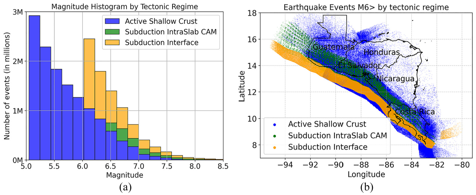
(a) Magnitude histogram of the stochastic earthquake catalog split by tectonic regime. (b) Location of events with magnitudes above 6.0 by tectonic regime. Costa Rica, El Salvador, and the Pacific Coast of Guatemala and Nicaragua are subject to both ASC and subduction events. The rest of Guatemala and Nicaragua are primarily affected by ASC events, with the latter associated with seismic activity in the Motagua-Polochic fault.
Exposure and vulnerability model
This study used the GEM exposure model (Yepes-Estrada et al., 2023), which is built upon from national census of each country and information compiled in the World Housing Encyclopedia (WHE) (Brzev et al., 2004). The exposure model characterizes the spatial distribution of the building stock, building classes, and occupancy rates (Calderón et al., 2022). Building typologies are defined using the GEM Building Taxonomy, which includes key parameters such as construction material, number of stories, lateral load resisting system, and occupancy type (Brzev et al., 2013). Each asset in the model is associated with a specific building class, and a time-averaged number of occupants is assigned to it based on its typology. These occupancy values account for fluctuations in building usage throughout day (daytime, transit, nighttime) and are consistent with the overall population distribution of each country. The model maps residential buildings at the municipality level, while commercial and industrial buildings are less detailed and modeled at the department level. Across the three larger countries, the median municipality size is on the order of 250 km2; for El Salvador it is about three times smaller. In subsequent maps, the regional sub-divisions represent the municipalities.
Figure 2 shows the building ratio, calculated by grouping the number of buildings by material type and dividing by the total number of buildings. The total number of buildings is as follows: Costa Rica has 1.5 million, El Salvador 1.6 million, Guatemala 3.1 million and Nicaragua 1.4 million. The materials are ordered according to their seismic performance, from the weakest at the bottom to the strongest at the top. This arrangement is based on the likelihood of reaching a complete damage state under SA of 0.3 s for low-rise story structures. Wood, unreinforced masonry, stone or adobe blocks are materials with brittle behavior, low ductility, and weak connections between structural elements; these construction materials are highly vulnerable but remain popular due to their affordability and simple construction (Calderón et al., 2022). Over 7.4 million people in El Salvador, Guatemala and Nicaragua live in vulnerable structures made of unreinforced masonry, adobe or stone blocks. In contrast, adobe has been banned in Costa Rica for over 100 years. For detailed information on occupant ratios, refer to Figure S1 in the Electronic Supplement.
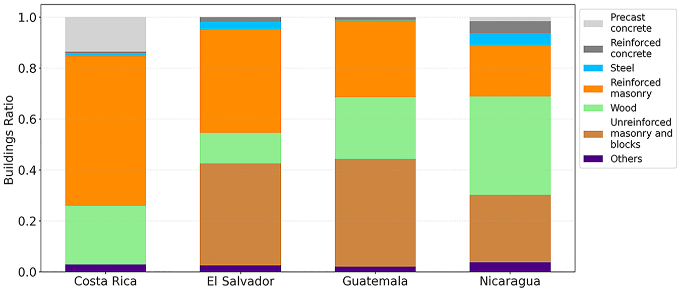
Distribution of building material types for each country. Materials are ordered by their vulnerability and range from the weakest at the bottom to the strongest at the top.
The following discussion focuses on the comparison between building ratio across countries, the total number of buildings are given in parenthesis. In Guatemala and El Salvador, unreinforced masonry, adobe or stone blocks structures represent at least 40% of the building stock (1.2 million and 0.7 million, respectively). In Nicaragua, such materials account for 25% of the building stock (0.4 million). Overall, 7.4 million people reside in these vulnerable structures across the three countries. The predominant building material in Costa Rica is reinforced masonry, comprising 60% of the building stock (0.9 million) and accommodating 2.24 million people, followed by wooden structures that house about 0.7 million people. A significant portion of wooden structures present in the exposure model were built before the implementation of building codes, suggesting a low seismic performance (Calderón et al., 2022). Unlike the other countries, adobe construction is nearly non-existent in Costa Rica due to its prohibition after the significant damage observed in the M6.7 Cartago earthquake in 1910 (Calderon and Silva, 2019). Overall, low-quality housing represents only a small amount in Costa Rica indicating a positive trend toward seismic-resistant structures (Maria and Acero, 2018).
Figure 3 presents mean vulnerability functions for fatality rates, in terms of SA at periods of 0.3 s and 0.6 s, with material type color-coding consistent with Figure 2. The vulnerability functions show the fatality rate corresponding to a given IM level, derived by multiplying the probability of each damage state (e.g. slight, moderate, extensive, complete) by the associated fatality rate and summing the results across all damage states. Unreinforced masonry structures exhibit a rapidly increasing probability of fatality at lower acceleration levels compared to the remaining materials. This material is particularly heavy compared to wood, resulting in fatality rates eight times higher. In contrast, reinforced masonry, reinforced concrete, and steel structures only show damage at higher acceleration levels, their fatality rates are 20% lower than unreinforced masonry showing a better earthquake performance. The casualty rates were adopted from the HAZUS consequence model (Federal Emergency Management Agency (FEMA), 2010), further details on casualty assessment are available in (So, 2016). The GEM fragility functions employed here were developed through an analytical method combined with damage observations from recent events in Central America (Calderon and Silva, 2019). The building classes of HAZUS and GEM were matched using the recommendations provided in Brzev et al. (2013). The building taxonomy is shown in Table S1 in the Electronic Supplement, the HAZUS building classes corresponding to each material type are detailed. A similar plot for injury rates is shown in Figure S2 in the Electronic Supplement.
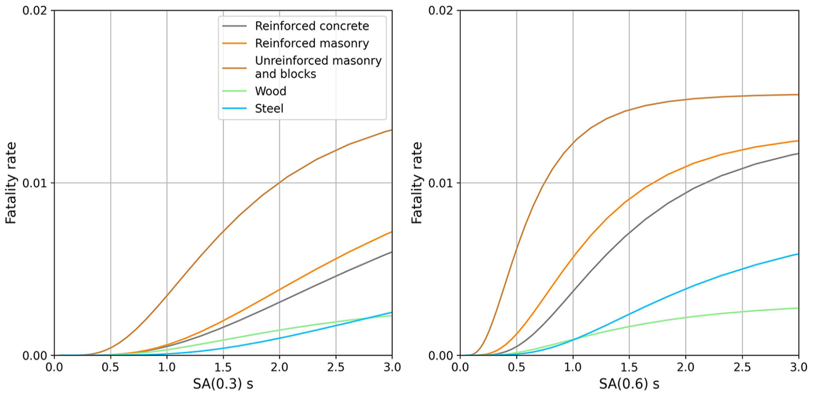
Mean vulnerability functions for fatality estimation in terms of spectral acceleration in g at periods of 0.3 and 0.6 s by the corresponding material. The functions are color-coded by material type. The probability of fatality for unreinforced masonry structures begins to increase rapidly at lower acceleration levels, making them the most vulnerable typologies.
Seismic risk without EEW
Seismic risk is the convolution of hazard, vulnerability, and exposure. By combining these components, we can estimate potential injuries and fatalities for each country using the stochastic catalog. Due to incomplete data on commercial and industrial buildings, we focused on residential buildings to ensure a homogeneous analysis across countries which are aggregated at the municipality centroids. The probable maximum loss (PML) represents the expected level of loss associated with a given return period of exceedance. Figure 4a presents PML curves for fatalities at different return periods in the scenario without EEW. The solid line denotes the mean, and the shaded area represents the 95% confidence interval across the 27-GMM logic branches of the Caribbean and Central American Earthquake Hazard Model (Garcia-Pelaez et al., 2023). The black dashed line indicates a return period of 475 years, commonly used in seismic risk assessment. For this case, the corresponding number of fatalities and the percentage relative to the total current population are shown in parentheses: 1300 (0.03%) for Costa Rica, 3100 (0.06%) for Nicaragua, 6100 (0.12%) for El Salvador, and 11,200 (0.09%) for Guatemala. Guatemala and El Salvador exhibit a higher number of fatalities, which is associated with the elevated number of occupants in unreinforced masonry buildings.
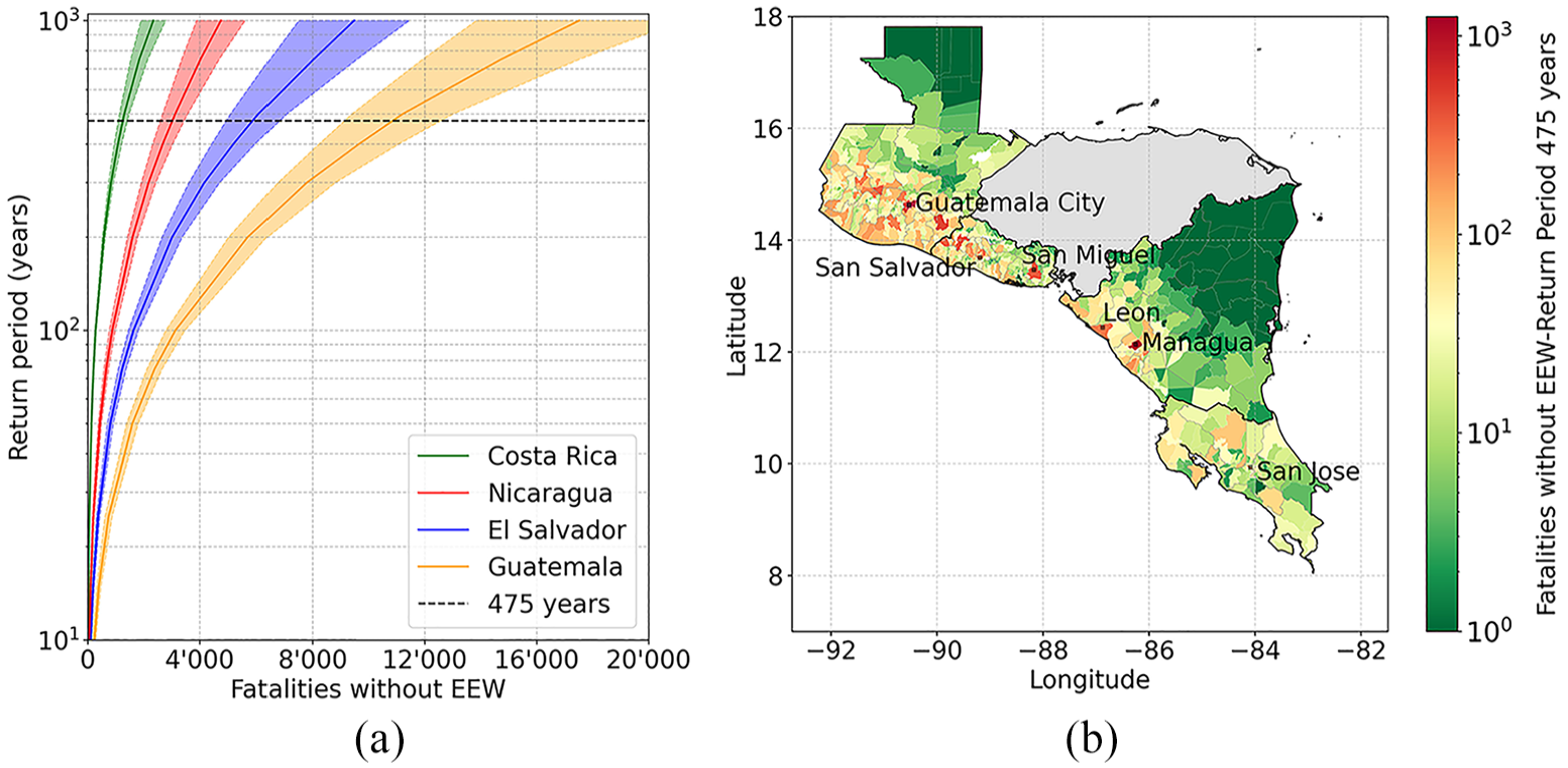
(a) Probable maximum fatality curves at different return periods without EEW for each country. (b) Mean number of fatalities at the municipality level for a return period of 475 years. Notable peaks are observed in Guatemala City and Managua with 1410 and 1050 fatalities, respectively. Key cities in each country are indicated in the map.
Furthermore, the mean number of fatalities at the municipality level for a return period of 475 years is shown in Figure 4b. Notable peaks are observed, particularly in the municipality of Guatemala City, with 1410 fatalities. In El Salvador, the municipalities of San Miguel and San Salvador report 370 and 230 fatalities, respectively. In Nicaragua, Managua and Leon have 1050 and 273 fatalities, respectively. In Costa Rica, San Jose shows a much lower number, with 125 fatalities. These municipalities are located near the active shallow crustal faults and the subduction zone, with casualties mainly related to the seismicity of these tectonic regimes. In addition, lower values of fatalities indicated in green are observed in the Peten region in northern Guatemala and in the Caribbean region of Nicaragua. This area is not affected by subduction seismicity and is mainly governed by crustal shallow seismicity with low activity. Figure S3 in the Electronic Supplement shows the number of injuries.
Seismic risk mitigation through EEW
EEW systems serve as a risk mitigation tool by providing warnings before destructive seismic waves arrive, enabling individuals to take protective actions that can reduce casualties. In this section, we detail the parameters used in our analysis to quantify the mean reduction in casualties achievable through EEW, following the framework proposed by Papadopoulos et al. (2023). We present the results for the current public EEW systems, referred to as the “baseline scenario.” For each event in the stochastic catalog described in Section 2, we computed the expected warning time for each target site based on an existing strong motion seismic network. In addition, we estimated the proportion of individuals capable of successfully taking protective action given the warning time, based on a recent social science survey on EEW in Central America (Orihuela et al., 2023). The results obtained in the survey provide a benchmark for many of the assumptions required for this study.
EEW in Central America and estimation of warning times
After an 8-year effort through the ATTAC project, end-to-end public EEW systems based on national seismic networks are now available in Central America. Each nation runs the ETHZ-SED EEW (ESE) system (Massin et al., 2024), a SeisComP-based implementation of Virtual Seismologist (Cua et al., 2009) and FinDer (Böse et al., 2018) algorithms, which require ground motion observation at four and three stations, respectively, to trigger EEW alerts. The countries use common software but are independently operated by national government institutions, and, in the case of Costa Rica, a university. To obtain a fast and reliable EEW, high-level seismic network performance is needed. During ATTAC, the seismic network was densified by installing 72 EEW-ready strong motion stations. Further efforts that have improved EEW system performance include sustained careful metadata management; optimization of data logger configuration to reduce data delays; and region-specific adaptation of EEW algorithm configuration. First alerts are now available within 10 s of origin time for on-shore shallow seismicity, and in the range of 15–25 s for subduction and deep events, with false alarms being rare since 2023.
Alert dissemination to the public is chiefly through mobile applications. Apps for Android and iOS were developed to receive EEW alerts via push notifications. When an earthquake exceeds M5 in magnitude and the predicted shaking intensity surpasses MMI V, a “red alert” is triggered. This alert interrupts any ongoing device activity with a loud alarm and a take-over voice message, following the intensity prediction model by Allen et al. (2012). End-to-end transmission delays are in the order of 1 to 4 s for the majority of users. Public alerts were rolled out in the four countries between 2023 and 2024, and there are currently approximately 250,000 users in the region. Alerts are distributed to a much more limited number of users through the Emergency Warning Broadcast System (EWBS) via digital TV. In Costa Rica, Guatemala and El Salvador, this is only received by Civil Protection agencies. In Nicaragua, it is additionally distributed to 70 additional industry and community receivers (e.g. hospitals, universities, shopping centers, and international airport).
The seismic networks were originally designed to build earthquake catalogs, assess seismic hazards, and identify site effects impacting seismic risk in urban areas. Overall, the four networks include nearly 300 stations, comprising broadband, strong motion, and short-period sensors. While broadband and short-period sensors contribute to locations for all events, and for magnitudes for moderate events, they will saturate during major events and cannot contribute to magnitudes. In this study, we only use the 154 strong motion sensors to determine warning times. It is important to note that the OVSICORI seismic network in Costa Rica is primarily broadband-based, resulting in a sparse distribution. In our analysis, we assume continuous good operation of all 154 stations, in practice some stations are offline, slow, have limited dynamic range or have corrupted signals. We simulate the performance of EEW under ideal conditions and assume that magnitude and hypocenter are characterized without any error. Trugman et al. (2019) indicates that characterizing earthquakes with magnitudes below M < 6.5 takes less than 3 s, while 6.5 < M ≤ 7.0 require approximately 4 s. Given that the EEW algorithm requires data from four stations, it is reasonable to assume that by the time P-waves reach the fourth station, the nearest station has recorded sufficiently long data to initially provide a reliable magnitude estimate for sending alerts.
Figure 5a shows the interstation distance within these networks, defined as the average distance to the nearest three stations for a given station. Notably, 78% of interstation distances are under 20 km, and almost all are within 60 km. Figure 5b maps the locations of stations, shown as blue triangles, revealing clusters near populated cities. In this analysis, station density is calculated only for seismically active regions. For Costa Rica and El Salvador, all regions are considered. In Nicaragua, only the regions along the Pacific Coast are included, while for Guatemala, all regions are included except for Peten. The overall station density is 102 (station/km2), which falls short of the optimal 102 (station/km2) recommended by Kuyuk and Allen (2013). This indicates potential for further improvement in warning times, which will be explored in Section 4. While recent efforts on the seismic networks have focused on enabling and enhancing EEW capabilities, it is clear further development is still required.
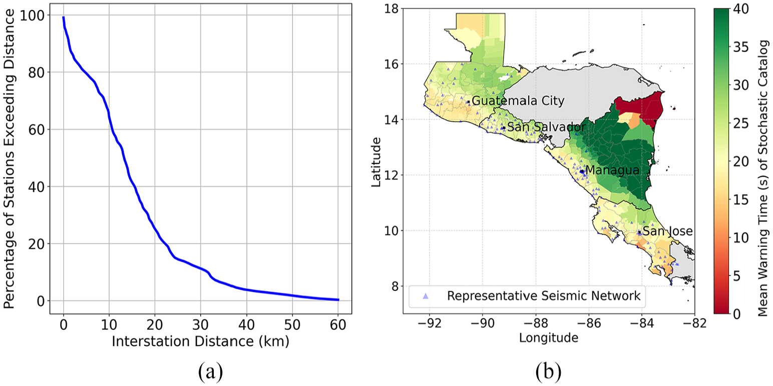
Existing strong motion seismic network used for casualty reduction (a) distribution of interstation distances and (b) map of stations locations in blue triangles, the colorbar shows the mean warning time in seconds of the entire stochastic catalog.
In our study, the warning time is calculated as the time difference between the theoretically predicted P-wave arrival at four stations and the predicted S-wave arrival at the target site (the municipality centroid), consistent with the EEW algorithms implemented in Central America. We assume a latency of 2 s for the seismic stations that is subtracted from the theoretically warning times, and dissemination delay is not considered. The warning times are computed for each event-site combination in the stochastic catalog, and new casualty estimates are calculated as outlined in section 3.2. We adopt P- and S-wave velocities of 7.2 and 4.1 km/s, respectively, which correspond to lower crustal velocities (Arroyo et al., 2009; Quintero and Kissling, 2001). Consequently, these values are generally higher than those observed for shallow events, leading to slightly shorter warning times. In addition, we assume that real-time data from seismic stations is openly shared between countries. Figure 5b shows the mean warning time for the entire stochastic catalog with a standard deviation of ±5.6 s. In Costa Rica, El Salvador, Guatemala and along the Pacific Coast of Nicaragua, warning times range from 15 to 25 s. In central Nicaragua, subduction events are distant and allow warning times above 20 s. In the North Caribbean part of Nicaragua, warning time decreases due to the lack of nearby seismic stations, though seismic activity here is low.
Considerations for estimation of casualty reduction
Figure 6 presents the flowchart based on Papadopoulos et al. (2023), detailing the parameters employed to simulate the performance of the EEW system in the baseline scenario. In the subsequent optimization of EEW presented in Section 4, only the parameters highlighted in orange are modified. Equation 1 provides the number of casualties (

Here,

A successful dissemination depends on a fast and robust communication infrastructure to ensure the public receives alerts promptly (Suárez, 2022).
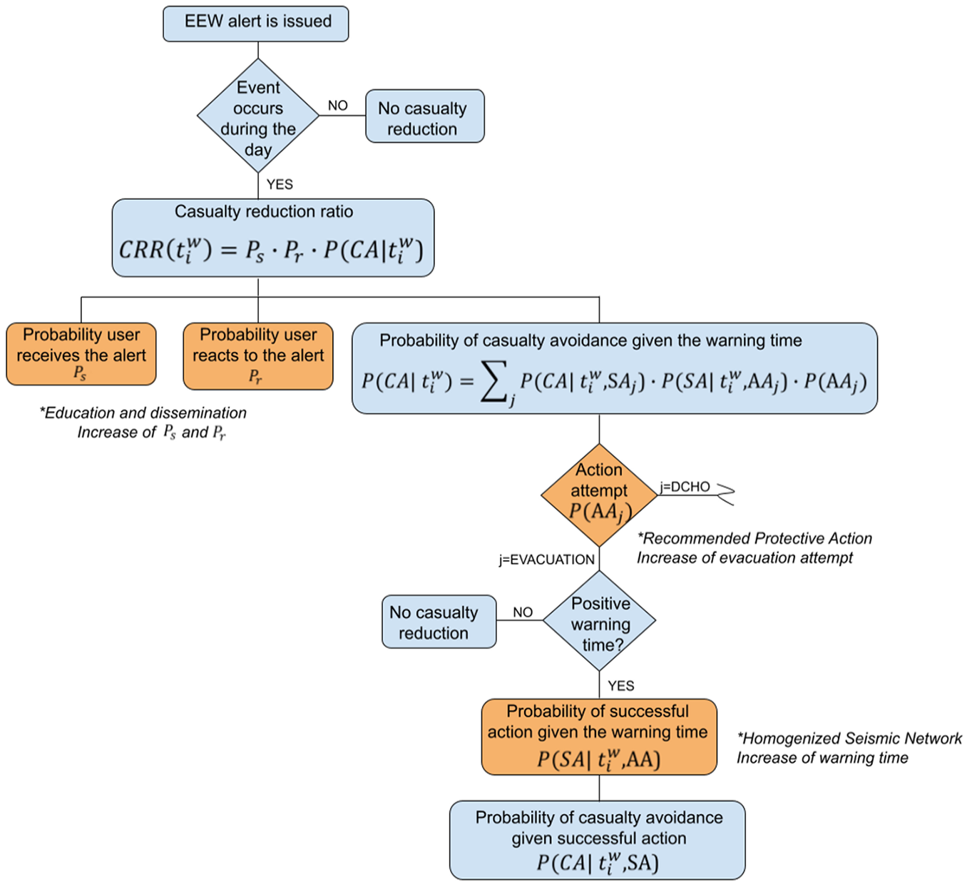
Schematic representation of the framework used to quantify the effectiveness of EEW in reducing casualties for the baseline scenario. Parameters highlighted in orange indicate those modified to optimize EEW effectiveness in Section 4, and the asterisk (*) specifies how it was adjusted (Adopted from Papadopoulos et al., 2023).
The aim of an EEW alert is to prompt users to take actions that improve their safety and reduce casualties.
where
The probability of successfully completing an attempted action as a function of warning time is represented by
Casualty reduction in the baseline scenario
The mean fatality reduction was calculated by comparing the estimated fatalities without EEW and with the operating EEW systems. Figure 7a shows the mean fatality reduction for the baseline scenario across different return periods. The following discussion focuses on a return period of 475 years, with the mean number of fatalities avoided due to the operational EEW systems provided in parentheses to give a sense of the absolute impact. The fatalities at the national level associated with the return period could be reduced by 13.7% (180) in Costa Rica, 16.2% (506) in Nicaragua, and 16.8% (1017 and 2615) in El Salvador and Guatemala, respectively. The contribution of subduction events increases with higher return periods, providing longer warning times that result in greater fatality reductions, as shown in Figure 7a.
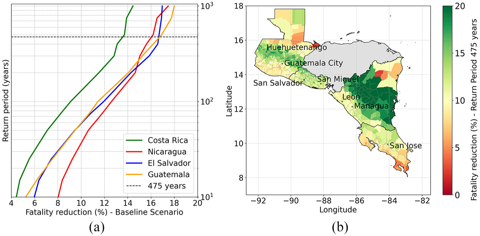
(a) Mean fatality reduction associated with an EEW system for the baseline scenario. (b) Mean fatality reduction at the municipality level for a return period of 475 years. In municipalities with the highest numbers of fatalities, such as Guatemala City and Managua, the fatality reduction could reach 11.3% and 9.1% translating to 160 and 96 fewer fatalities, respectively.
Figure 7b shows the mean fatality reduction at the municipality level for a return period of 475 years. The fatality reduction could reach 11.3% (160) in Guatemala City. In El Salvador, the municipalities of San Miguel and San Salvador could achieve 11.9% (45) and 14.6% (35) fatality reduction. In Nicaragua, Managua and Leon can reach a fatality reduction of 9.1% (96) and 11.7% (31). In Costa Rica, San Jose would have a fatality reduction of 9.3% (12). The highest fatality reductions, ranging from 14% to 20%, are seen in central Nicaragua and Guatemala. These regions, still affected by large subduction events, are so far from the subduction zone that they have long warning times. In Nicaragua, these high reductions are associated with a small number of fatalities, fewer than 10. Central Guatemala benefits the most, with an average fatality reduction of 16%, for example resulting in 45 fatalities avoided in Huehuetenango. Overall, the lowest reductions occur in areas with sparse seismic stations, and where seismicity is dominated by active shallow crustal events, resulting in limited warning times. Figure S4 in the Electronic Supplement shows the result for injury reduction.
Improvement of casualty reduction
In Section 3, we examined the baseline scenario using the “current” characteristics of the EEW systems, assuming a broad alert distribution. In this section, we analyze the effect of specific parameters within the framework, modifying only the parameter under review while keeping others consistent with the baseline scenario. First, we explore the impact of increasing station density and model a homogenized seismic network to increase warning time. Second, we select the recommended protective action by comparing the effectiveness of evacuation and DCHO as potential strategies for reducing casualties in this region. Finally, we integrate the recommended protective action with a homogenized seismic network to evaluate their combined effect on casualty reduction. In addition, we evaluate the potential impact of public awareness and alert dissemination on casualty reduction, and assess the economic benefits of implementing EEW systems in Central America. Note that, in this section, we calculate the change in mean casualty reduction from the baseline scenario, rather than comparing it to a scenario without EEW. This approach highlights the improvements achieved by an enhanced EEW system. The number of fatalities avoided from the baseline scenario is indicated in parentheses to give a sense of the absolute impact. A 0% change in casualty reduction indicates no improvement from the baseline scenario, whereas 100% would represent twice the casualty reduction obtained in the baseline scenario. Figure S6 in the Electronic Supplement shows the change in injury reduction.
Homogenized seismic network
We explore how increasing station density and establishing a homogenized strong motion seismic network result in longer warning times. These longer warning times are associated with higher values of
Figure 8a presents the change in fatality reduction for a homogenized seismic network across various return periods. The results suggest that the positive change is more pronounced for shorter return periods, and it becomes moderate as the return period increases. The tendency can be attributed to the contribution of different tectonic regimes, which vary with the return period. For shorter return periods, the seismic activity is predominantly influenced by Active Shallow Crustal events. It is within these events that the homogenized seismic network provides the longest warning time improvement. In contrast, longer return periods are dominated by offshore subduction events, which occur far from seismic stations, resulting in warning times comparable to the baseline scenario. For a return period of 475 years, the change in fatality reduction from the baseline scenario, using the homogenized network, is as follows: Nicaragua at 1.9% (10), El Salvador at 4.5% (30), Costa Rica at 10.8% (20), and Guatemala at 11.1% (170). Figure 8b displays the change in fatality reduction at municipality level. In the baseline scenario, the existing strong motion seismic network is sparsely distributed along the Pacific Coast of Guatemala and Costa Rica. These areas gained additional warning time, leading to a significant increase. This is crucial, particularly in Guatemala, where hundreds to thousands of fatalities are expected. In El Salvador and most of Nicaragua, changes in fatality reduction range from 0% to 5%, with San Salvador showing a 4% (2) improvement and Managua a 5% (5) improvement. In Costa Rica, the change in fatality reduction is more pronounced, ranging from 10% to 20%, with the Pacific Coast regions benefiting the most. San Jose exhibits a change of 21% (3). On the Pacific Coast of Guatemala, the change in fatality reduction spans from 15% to 30%, while in central Guatemala, it varies between 5% and 15%. Guatemala City shows a change of 10% (16). The North and Caribbean regions of Guatemala and Nicaragua show a change of over 15%, though these areas are associated with a small number of fatalities (< 10).
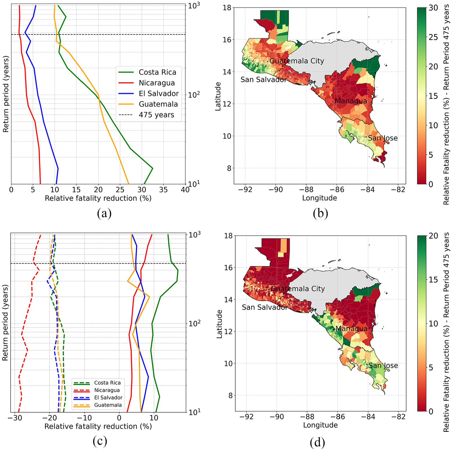
Relative change in mean fatality reduction from the baseline scenario, with map results provided for a return period of 475 years. Homogenized Seismic Network: (a) The improvement in fatality reduction ranges from ~2% to 5% in Nicaragua and El Salvador, and ~11% in Guatemala and Costa Rica. (b) At the municipality level, the Pacific Coast of Guatemala and Costa Rica shows the most significant benefit, with an increase ranging from 20% to 30%. Recommended Protective Action: (c) Increasing the percentage of occupants attempting DCHO (dashed lines) results in a decrease of ~25% in fatality reduction. In contrast, protective action tailored to building height (solid lines), where occupants on the first floor evacuate and those on upper floors adopt DCHO, leads to an increase of 4% to 15%. (d) The results correspond to the solid lines in (c), showing the municipality-level impact of protective action tailored to building height, with an increase of 10% to 20% in the Pacific Coast of Nicaragua and Costa Rica.
Recommended protective action
In countries with strong building code adherence such as Japan, the United States, Taiwan, DCHO is commonly advised (Wood, 2018). However, in Guatemala, El Salvador and Nicaragua, at least 40% of the building stock is constructed with unreinforced masonry and blocks. These materials are highly vulnerable to damage or collapse during strong ground motions. In countries with similar building vulnerabilities, such as Mexico, Haiti, and Nepal (McBride et al., 2022; Rapaport and Ashkenazi, 2019; Vaiciulyte et al., 2022), government guidelines recommend that individuals on lower floors evacuate to an open space. Furthermore, we notice that high-rise buildings constitute only a minor fraction of the overall building stock in Central America, with the majority of households consisting of individual low-rise structures. From the GEM exposure model, 70%–90% of occupants live in single-story buildings, 10%–25% live in two-story buildings, 2%–6% in three-story buildings, and less than 1% in high-rise buildings. Figure S5b in the Electronic Supplement provides a map at the municipality level of average occupancy in single-story buildings.
Motivated by the absence of official guidance from any Central American country on actions to take during earthquakes, we compare the impact of different protective actions on reducing casualties. We examine two cases: (1) increase the proportion of occupants attempting DCHO,
Figure 8c compares the effectiveness of the two different protective action strategies in minimizing fatalities. The change in fatality reduction from the baseline scenario is nearly constant throughout the return periods for both cases. The results show that increasing the percentage of occupants attempting DCHO (dashed lines) leads to a significant increase of 20%–25% in fatalities compared to the baseline scenario. This outcome is influenced by the modeling assumption for
Figure 8d maps the change in fatality reduction when the protective action is tailored to building height at the municipality level with respect to the baseline scenario. In Costa Rica and along the Pacific Coast of Nicaragua, where at least 70% of occupants reside in single-story buildings, this leads to a moderate increase of 10% to 20%. In particular, San Jose shows a 17% (2) improvement, while Managua exhibits a 20% (18) improvement. Conversely, in El Salvador and Guatemala, the percentage of occupants in single-story buildings decreases, specifically in the capital cities, resulting in an increase below 5%. San Salvador shows a 5% (2) improvement, and Guatemala City 2% (3) improvement.
Combined effect and benefit–cost analysis
In this section, we integrate the homogenized seismic network with protective actions tailored to building height to evaluate their combined effect on fatality reduction. Figure 9a presents the change in fatality reduction for the combined effect (solid lines) from the baseline scenario. For a return period of 475 years, an improvement in fatality reduction is achieved for all countries as follows: Nicaragua at 9.2% (38), El Salvador at 3.1% (26), Costa Rica at 12.7% (20), and Guatemala at 6.7% (105).
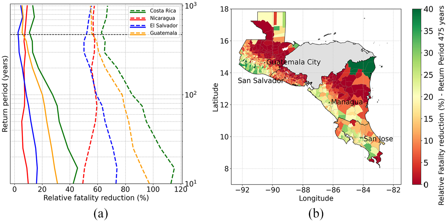
Relative change in fatality reduction from the baseline scenario, with results provided for a return period of 475 years. (a) Combined effect of a homogenized seismic network and protective action tailored to building height (solid lines) results in an increase of ~3% to 7% in El Salvador and Guatemala, and ~9% to 13% in Nicaragua and Costa Rica. Increasing the parameter
It is worth noting that the improvement of fatality reduction is strongly dependent on the parameter
The economic benefits of implementing EEW systems in Central America were evaluated using a cost-avoidance approach (Bouta et al., 2020) over a 25-year period consistent with the typical lifespan of seismic monitoring infrastructure including high-quality seismometers, data loggers, and power systems. Table 1 shows the average annual number of fatalities avoided due to EEW over a 25 years, and annual fatality reduction is presented in brackets relative to the no-EEW scenario. The five scenarios considered are ordered in terms of effectiveness: (1) Increasing the percentage of occupants attempting DCHO,
Cases ordered in terms of effectiveness: potential average annual fatalities avoided due to EEW and economic savings in millions of US$ during a lifetime of 25 years
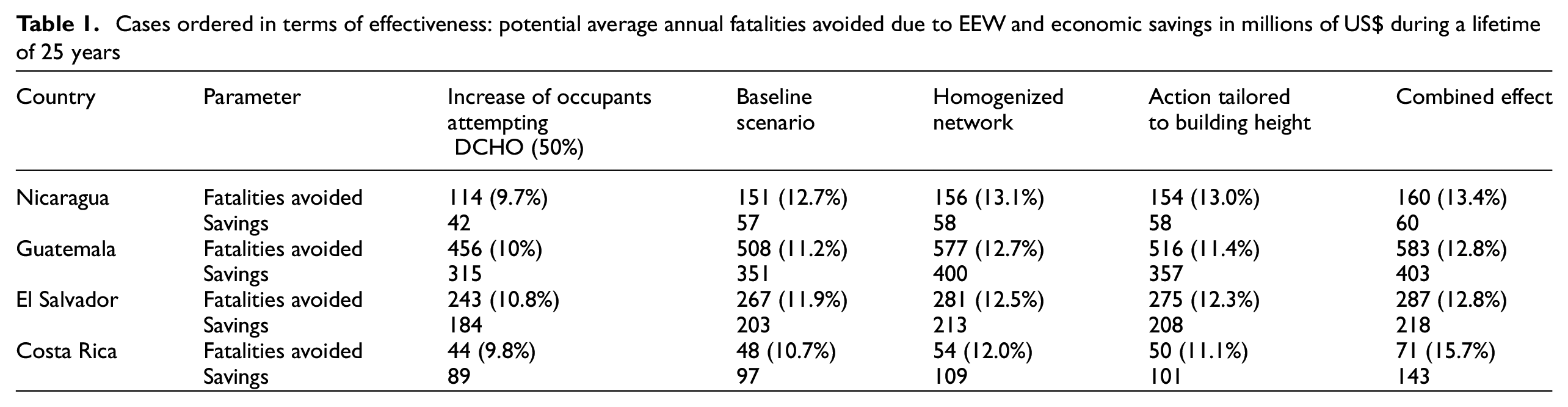
Table 1 also includes the economic savings for each scenario for each country, which are calculated as the difference between the average annual loss (AAL) with and without EEW. These savings are determined by multiplying the fatalities avoided and the VSL per country. VSL is a common (though controversial) metric employed in public policy and insurance sectors (Silva et al., 2023). The VSL values in this study were adopted from Hoyos and Silva (2022), who conducted a cost–benefit analysis of seismic retrofitting in the same Central American countries. The VSL for each country are as follows: Costa Rica 2 million USD, Guatemala 0.7 million USD, Nicaragua 0.4 million USD, El Salvador 0.8 million USD. In this study, only fatalities were considered, as the costs associated with injuries are significantly lower (Hoyos and Silva, 2022; Silva et al., 2023).
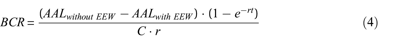
The implementation of an EEW system entails significant costs, including development, installation, and ongoing maintenance. In Central America, the initial 8 year investment of approximately 1.3 million USD for the four countries was funded through the ATTAC project by the Swiss Agency for Development and Cooperation. In addition, national institutions also contributed roughly 1 million USD annually in the case of Costa Rica and Guatemala. The EEW systems were built on existing seismic network infrastructure and operating organizations in each country. However, further investment is required to establish mature, nation-wide EEW systems capable of providing alerts to the 37 million people living in these countries. For estimating the eventual costs, we compare with other systems, though there is a very large variation. Wenzel (2005) estimated annual expenses of 400,000 USD to provide alerts to 2 million people in Bucharest. Mexico operates with an annual budget of 8 million USD to alert 25 million people (Gonzalez Escarcega, 2017). Japan has invested nearly 1 billion USD in its national system, and provides alerts to 125 million people (Allen, 2013). The initial cost for Shake Alert was 120 million USD, with an annual maintenance budget of 16 million USD covering 51 million people in California, Oregon and Washington (McBride et al., 2020; Strauss and Allen, 2016). Even though it is not plausible that the ShakeAlert budget can be adopted in Central America, given that the number of recipients in Central America is comparable to those in the United States, the total cost including the initial cost and annual maintenance, provides an upper bound for our analysis. Equation 4 presents the Benefit–Cost Ratio (BCR) and compares the expected net present value of future economic benefits—calculated as the difference between the AAL without EEW and the AAL after the implementation of EEW—against the incurred costs (C) of implementing EEW systems. We applied a discount rate (r) of 4%, a standard value in Latin American countries (Weitzman, 2001), and considered a project duration (t) of 25 years. The BCR for all Central American countries together is 21 for the baseline scenario, indicating that the economic benefits clearly outweigh the costs. These findings strongly support the full implementation of public EEW systems in Central America.
Discussion
In this manuscript, we estimate the reduction in casualties attributed to an EEW system in Central America using a probabilistic framework. For this analysis, EEW alerts reach most of the population with reasonable latencies, and users respond appropriately. The objective is to estimate the upper bound of what an efficient and well-implemented EEW system could achieve, rather than to reflect current performance. This effort is challenging due to the many assumptions required, that deserve additional reflection. This section discusses the limitations and potential strategies for improvement of the parameters involved in the analysis. Currently, EEW systems do exist across Central America and provide low latency and reliable service, though they only reach a small section of the population via a mobile phone application, with a current maximum reach of about 100k users, or 2% of the population, in each of El Salvador and Costa Rica. End-to-end transmission delays for the mobile app are in the range of 1 to 4 seconds. Nevertheless, our analysis considers a broader scenario where alerts are disseminated to the majority of the population,
In the first part of the framework, we estimate casualties in the absence of EEW using the GEM Central America and Caribbean (CCA) earthquake risk model. However, the framework is flexible and can accommodate alternative hazard models. Instead of focusing on a single scenario, we employed a comprehensive stochastic catalog that samples all possible ruptures and their associated occurrence rates. To compute casualties, we adopted the following simplifications: (1) the number of occupants in each building is fixed in time; (2) all assets are located at the centroid of the municipality; and (3) vulnerability functions for fatality and injury estimation were derived from the HAZUS consequence. The second part of the framework quantifies casualty reduction from EEW by incorporating two key elements: the characteristics of the EEW system and the subsequent actions taken upon receiving the alert.
A primary assumption in this study is that the earthquake source is accurately estimated within seconds of detecting strong motion by the EEW system. While this is optimistic, as no EEW system guarantees such performance, in practice most EEW systems are triggered by a relatively low alerting threshold. For the ATTAC EEW system, a “red alert” alert is issued to users when the earthquake magnitude exceeds M5 and the predicted ground motion surpasses MMI V. This approach enables the system to trigger alerts before the earthquake is fully characterized, as smaller events are more likely to exceed the threshold. Massin et al. (2024) demonstrate that the ATTAC EEW systems are reliable and have not issued false alerts as of September 2024. The relatively low shaking threshold ensures that even those experiencing moderate shaking are advised to take precautions. Hence, failure of the system to recognize major events is less critical. Further research is required to establish an optimal shaking intensity threshold and to evaluate the trade-offs between missed and false alerts. Minson et al. (2019) indicates that systems with low alert values tend to be more beneficial by minimizing missed alerts, although they may result in higher rate of false alerts.
The framework adopts a conservative approach by assuming no casualty reduction for earthquakes that occurred during the night as there is limited data on human behavior during these periods. Silva et al. (2023) consider that only 50% of the population might react during the night, and those who react may take twice as long to complete their actions. Incorporating such considerations could increase the casualty reduction observed in our analysis.
The probabilistic models of successful DCHO and evacuation given the warning time,
We evaluate the expected performance of the EEW system for a repeat of the M7.5 Guatemala (1976) earthquake. The event initiated on the Motagua Fault about 160 km NE of Guatemala City and far from other major population centers such as Mixco and Antigua. The WSW part of the bi-lateral rupture included large displacements that extended toward the capital city (Plafker, 1976). This event provides an ideal case for EEW as there can be significant warning time for many populated areas that experienced heavy damage. The analysis of this event estimates approximately 15,000 fatalities and 240,000 injuries. While these numbers are lower than the observed casualties in 1976 (Espinosa, 1976), despite the population nearly tripling over the past 50 years, various factors may contribute to this difference. One potential factor is the incorporation of modern structures with improved earthquake performance, though further analysis is needed to fully understand the reasons behind the variation in casualties. The baseline EEW system is projected to save 3000 lives and prevent 43,500 injuries with a general reduction of 20% of casualties. The current configuration of the seismic network could allow 35 s of warning time for Guatemala City, where most of the fatalities are concentrated, and the blind zone has a 45 km radius.
The strong motion station density varies across countries, with Guatemala at 4 × 10⁻⁴ stations/km2, Costa Rica at 8 × 10⁻³, Nicaragua at 3 × 10⁻³, and El Salvador at 2 × 10⁻³. As discussed in Section 4, Guatemala and Costa Rica benefit the most from implementing an EEW-ready homogenized seismic network at 20 km spacing, as their station density would increase tenfold. However, further enhancement of the seismic networks in Nicaragua and El Salvador remains critical. As noted in Section 2, the analysis assumes that all seismic stations are always operational with low latency and are EEW-ready, which does not reflect the actual situation. Expanding and upgrading the stations is crucial to achieving a more robust system with low latency. With the current investment in seismic networks, this is not happening. To improve, or even maintain the system as it operates today, continued investment at an increased level is mandatory.
Across the region, approximately 40% of buildings belong to vulnerable structural typologies prone to damage or collapse, with at least 70% being single-story structures. We assessed the effectiveness of DCHO compared to evacuation as recommended protective action. Our results indicate that increasing the percentage of occupants performing DCHO leads to a sharp increase in fatalities compared to the baseline scenario. This decrease is attributed to the assumed limited effectiveness of DCHO in preventing fatalities when buildings suffer complete damage or collapse, particularly in structures made of heavy materials. In contrast, our findings suggest a decrease in fatalities when occupants on the first floor evacuate while those on upper floors practice DCHO. Costa Rica and Nicaragua benefit the most from this approach, due to their significant proportion of single-story buildings. The analysis suggests that evacuation is a regionally-appropriate strategy for reducing fatalities, considering the characteristics of the buildings. DCHO is widely practiced in countries with strict building codes and is extensively recommended globally, often without acknowledging that it is regional-specific advice. This generalization has contributed to misconceptions about the appropriate protective actions in countries with different building practices and seismic risk. In regions where the building stock is a mix of seismic-resistant and vulnerable structures, a single recommendation is not possible. For example, Mexico advises occupants on the first three floors to evacuate, while those on higher floors DCHO. Given the seismic hazard and typically shorter warning times in Central America, evacuation is only advised on the first floor. Note that our conclusions are conditional to our assumptions regarding the effectiveness of DCHO and evacuation in preventing fatalities.
Hoyos and Silva (2022) analyzed different retrofitting interventions for buildings constructed with unreinforced masonry, adobe, or stone blocks. The average annual fatality reduction with retrofitting is nearly 90% compared to ∼10%–15% obtained through EEW. The BCR for retrofitting in Guatemala and El Salvador can reach up to 6, and up to 3 in Nicaragua. These values are significantly lower than the BCR for EEW. Retrofitting provides very high fatality reductions, but at a very high cost, and takes a significant time to realize. In contrast, EEW provides moderate casualty reduction, but at a very low cost and can be implemented rapidly. While retrofitting remains the optimal solution for reducing human casualties and building damage, it is an expensive, challenging and long-term effort. In contrast, EEW offers a more immediate and cost-effective mitigation strategy. Both should be targeted.
Conclusion
The high incidence of casualties during major earthquakes in Central America can be attributed to the widespread presence of vulnerable building structures. A significant portion of the building stock, except in Costa Rica, comprises unreinforced masonry and adobe blocks. The seismic hazard is predominantly concentrated along tectonic plate boundaries, which impact the entire Pacific Coastline of Guatemala and Nicaragua, as well as the entire territory of El Salvador and Costa Rica. Unfortunately, this is the same region where the majority of the population resides. Given the earthquake hazard throughout the region, EEW systems have the potential to reduce casualties. These four countries have been operating an independent public EEW system since 2023 through the ATTAC project. Given the “current” configuration of the EEW system and existing seismic network, serving as a baseline scenario, for a return period of 475 years the national fatality reduction ranges from ∼13% to 17%. This reduction corresponds to ∼1000–2600 fatalities avoided in El Salvador and Guatemala, and ∼200–500 in Costa Rica and Nicaragua.
Furthermore, the study evaluates the improvement in casualty reduction upon the implementation of a homogenized seismic network and action plan tailored to building height. The baseline scenario serves as a reference point to calculate the change in casualty reduction for an improved EEW system. The homogenized strong-motion seismic network considers an interstation distance of 20 km in high-hazard seismic zones and densely populated areas. This new network has three times more stations with strong motion sensors compared to the baseline scenario. For a return period of 475 years, the results indicate an increase of ∼10% in casualty reduction for Guatemala and Costa Rica. In contrast, Nicaragua and El Salvador experience an increase of ∼3%. Nonetheless, further improvement to the seismic network remains critical in all countries, as many existing stations are either not yet EEW-ready or are not always operational. In Central America, where a vast majority of buildings are single-story, evacuation within a short time is generally feasible for occupants on the ground floor. We model a scenario where occupants of the first floor evacuate while those on upper floors DCHO. For a return period of 475 years, we observe an increase of ∼5% in casualty reduction for El Salvador, Guatemala, and Nicaragua, and 15% in Costa Rica. It is crucial to tailor EEW messaging to local conditions, currently there is no official guidance on recommended actions during earthquakes. This evaluation provides a valuable assessment of the efficacy of evacuation as a recommended action, and we hope these findings will be considered in future developments of EEW in the region. This insight is particularly relevant for countries with high seismic risk and low compliance with seismic codes, where governmental recommendations for protective actions are often lacking.
When we combine the effects of a homogenized seismic network and occupants in the first-floor evacuating, for a return period of 475 years the increase ranges from ∼3% to 9% in El Salvador, Guatemala, and Nicaragua, and 13% in Costa Rica. We recognize there would also be a significant increase in casualty reduction by expanding the proportion of the population who receive alerts –incorporating additional dissemination channels such as cell broadcasting or public sirens– and by increasing the number and speed of people taking appropriate action. This could be facilitated through education campaigns that include earthquake drills. Finally, we conducted a cost–benefit analysis, calculating the AAL with and without the implementation of EEW, based on the stochastic catalog. Our findings indicate that the adoption of EEW could result in a reduction of up to 15% in average annual fatalities. The economic benefits of public EEW systems significantly outweigh the associated costs, strongly supporting the nation-wide implementation of EEW in Central America.
Supplemental Material
sj-docx-1-eqs-10.1177_87552930251342826 – Supplemental material for Impact assessment of earthquake early warning systems in Central America
Supplemental material, sj-docx-1-eqs-10.1177_87552930251342826 for Impact assessment of earthquake early warning systems in Central America by Benazir Orihuela, Athanasios N Papadopoulos, John Clinton, Griselda Marroquin, Marino Protti, Wilfried Strauch, Robin Yani-Quiyuch, Laurentiu Danciu and Stefan Wiemer in Earthquake Spectra
Footnotes
Declaration of conflicting interests
The author(s) declared no potential conflicts of interest with respect to the research, authorship, and/or publication of this article.
Funding
The author(s) disclosed receipt of the following financial support for the research, authorship, and/or publication of this article: This study is a core component of the ATTAC (Alerta Temprana para Terremotos en América Central) project funded by the Swiss Agency for Development and Cooperation (SDC) and the Swiss Government Excellence Scholarship (grant reference: 2021.0509).
Data availability statement
The data generated and/or analyzed during the current study are available in the provided references.
Supplemental material
Supplemental material for this article is available online.
References
Supplementary Material
Please find the following supplemental material available below.
For Open Access articles published under a Creative Commons License, all supplemental material carries the same license as the article it is associated with.
For non-Open Access articles published, all supplemental material carries a non-exclusive license, and permission requests for re-use of supplemental material or any part of supplemental material shall be sent directly to the copyright owner as specified in the copyright notice associated with the article.