
Abstract
China is currently carrying out the reform of territorial spatial planning. With the method of literature review, this paper gives a brief introduction to the development course of spatial planning in the United States, the United Kingdom, the Netherlands, Germany, France, and Japan. After that, the four stages of China’s spatial planning development and the main contents of the current territorial spatial planning are introduced in detail. Then this paper explores the important factors affecting the development of spatial planning and the coping strategies of various countries through international comparison and discusses the enlightenments of the coping strategies of other countries to China. The study indicates that Chinese spatial planning has gone through the multi-planning stage, which comprises major functional zone planning, regional planning, territorial planning, urban and rural planning, and eco-environmental protection planning. Additionally, under the influence of multiple factors such as spatial resources, social factors, international events, environmental crises, and urban problems, China has formed the territorial spatial planning system with ecological civilization as its core concept and high-level governance, high-quality development, and high-quality life as its main planning objectives.
Keywords
Introduction
In May 2019, the Central Committee of the Communist Party of China (CPC) and the State Council of the People’s Republic of China (hereafter “the State Council”) issued the document “The guidance on establishing the territorial spatial planning system and supervising its implementation” (hereafter “The Guidance”) (The Central Committee of the Communist Party of China and the State Council, 2019). It not only emphasizes the integration of the original spatial planning (which will be introduced in Section 3), but also stresses the systematic, holistic, and reconstructive reform and top-level design of the spatial governance system. As the programmatic document of territorial spatial planning in China, it put an end to the 40-year-long conflict between various types of spatial planning. In short, it marked a “new era” of ecological civilization for Chinese spatial development and spatial governance (Zhang et al., 2020). This also marked the beginning of China’s territorial spatial planning reform as well. On May 28, the Ministry of Natural Resources issued The notice of the Ministry of Natural Resources on the comprehensive development of territorial spatial planning (hereafter “The Notice”) (Ministry of Natural Resources of the People’s Republic of China, 2019). This helped to further clarify the main points of carrying out the compilation, approval, and implementation management of territorial spatial planning and its related work in the near future.
Through literature review and qualitative comparison, the study briefly describes the development course of the spatial planning systems of six countries—the United States, the United Kingdom, the Netherlands, Germany, France, and Japan (Section 2). It then introduces the development course of the Chinese spatial planning (Section 3) and the main contents of the current territorial spatial planning of China in detail (Section 4). The study also summarizes the common factors that affect the evolution of spatial planning and compares the coping strategies of different countries including China based on Section 2, so as to put forward suggestions for the adjustment and optimization of China’s territorial spatial planning in the future (Section 5).
Spatial planning in different national settings
Different countries in the world have made many explorations in spatial planning. They have different priorities and different evolution processes and have summarized valuable experience in coping with different problems. Compared with many countries, China’s spatial planning development process is relatively late. Sorting out the process of various countries’ spatial planning systems and summarizing experience and methods will help to adjust and optimize China’s territorial spatial planning system in the future.
Therefore, taking six countries with relatively long spatial planning history as the object of study—the United States, the United Kingdom, the Netherlands, Germany, France, and Japan, their spatial planning systems and development courses—have been summarized to provide a brief overview of the evolution of spatial planning in a global context, which will be a reference for subsequent international comparison.
Comparison of spatial planning systems in different countries
At present, the planning systems of various countries can mainly be divided into three types according to the classification of planning hierarchy: four-tier, three-tier and two-tier (Cai et al., 2014) (Table 1).
Spatial planning hierarchy system of different countries.
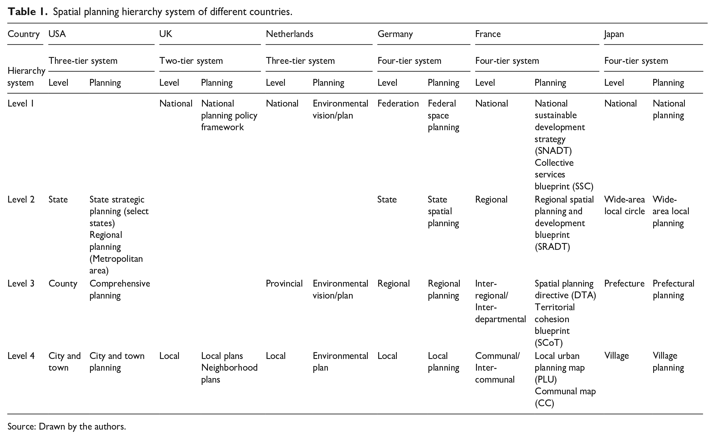
Source: Drawn by the authors.
The planning system of each country is closely related to its political and economic system (Xu et al., 2017). According to the degree of centralization, the spatial planning system in different countries can be divided into three types: the centralization, the decentralization, and the intermediate state. In a planning system under centralization, such as in Japan’s case, planning is administered uniformly by the planning agencies of governments at all levels. This type emphasizes the authority and strategy of territorial spatial planning (Zhong and Zhong, 2020). The spatial planning systems of France and the Netherlands also have the characteristics of centralization. There are clear planning levels in the spatial planning system that are consistent with the administrative level (Needham, 2005).
Under decentralization, such as in the case of the United States, planning functions are mainly concentrated in local governments (Cullingworth, 2004). Here, the social and private organizations play a leading role in spatial planning, not the federal government. In this way, local autonomy is preserved to the greatest extent, but correspondingly, the necessary co-ordination at the national level is insufficient (Xu et al., 2017). On the other hand, the planning system under the intermediate state is mainly seen in the United Kingdom and Germany (McGuinness and Mawson, 2017; Pahl-Weber and Henckel, 2008). This type of country has both a central government with strong control and local governments with a high degree of autonomy. The central government intervenes in local planning through legal and economic means and local governments generally deploy, compile, and implement according to the procedures of the central authorities (Xu et al., 2017).
In contrast, China has more levels in the planning system. The Chinese territorial spatial planning system has five clear levels, which matches with China’s administrative hierarchy (Country/Province/City/County/Town) (which will be fully introduced in Section 4). China’s planning system falls under the centralized administrative system and the governments at all levels are responsible for the planning and administration.
Spatial planning development course in various countries
Different countries have different stages and contents in their spatial planning development (Figure 1).
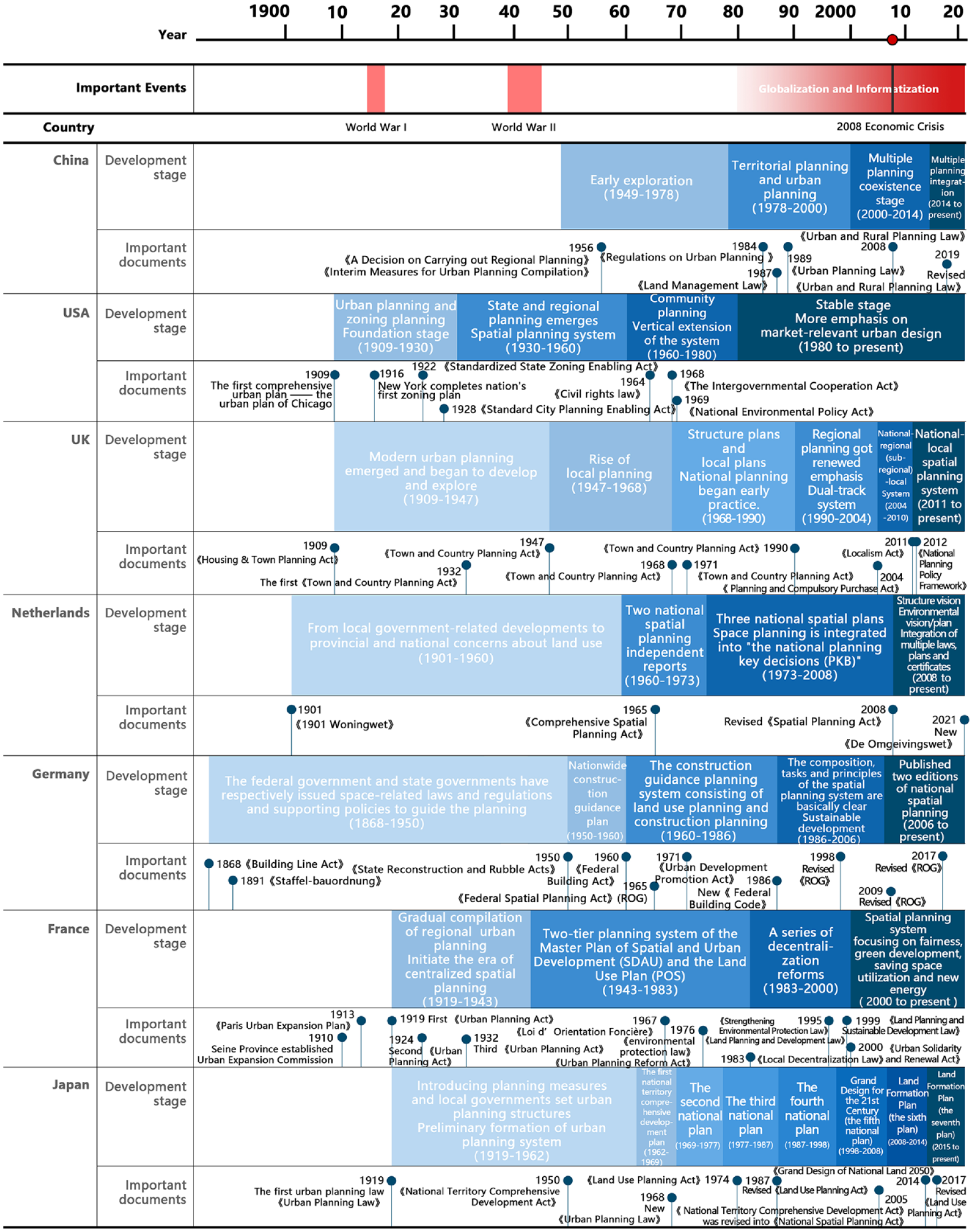
International comparison of the development course of spatial planning.
Strictly speaking, the United States only has the regional planning with each metropolitan area as the main body, but without the national territorial spatial planning (Cullingworth, 2004). The political systems of decentralization and local self-government in the United States determine that the planning system is dominated by local planning (Wang and Yao, 2020). From 1909 to 1930 (the initial stage), the urban planning began to be comprehensively compiled. Then came the gradual formation stage (1930–1960). After World War II, the rapid development of the city, construction of expressways, technological innovation, and large-scale population movement (Cullingworth, 2004) promoted suburbanization in the United States. This period saw the emergence and continual development of state and regional planning. Following this, the period from 1960 to 1980 became known as extended development stage, the neighborhood planning flourished. The years following 1980 were grouped under the stable stage. It saw the beginning of the neoliberal era and the need for a shift in economic models to make planning more focused on market-related urban design (Cai et al., 2017a).
The United Kingdom is one of the countries with relatively advanced planning system in the world (Wang and Yao, 2020). The evolution of its planning system is inseparable from the government’s implementation of local decentralization under the unitary system (Yang, 2016). The spatial planning system has evolved from being one-tier (“local development plan”) to two-tier (“structure plan” guided by the nation and “local plan”) to dual-track (some metropolitan areas adopted “unitary development plan” and the other areas still adopted “structure plan” and “local plan”) to three-tier (“national-regional-local plan”) and eventually two-tier (“national-local plan”), along with the changes in administration (Hall and Tewdwr-Jones, 2011; Zhou et al., 2017c). After the political party changed in 2011, decentralization reforms were introduced. The focus of planning shifted to the local level, causing regional planning to be abolished almost completely (Wannop and Cherry, 1994). Only the plan in London was retained as an exception (McGuinness and Mawson, 2017). So far, a “national-local” two-tier spatial planning system, including the “national planning policy framework” and the “local plan and neighborhood plan”, has been formed.
The Netherlands has scarce land resources, so it has a national culture of managing every inch of the territory (Zhou and Shen, 2017). The Dutch spatial planning originated from the need for urban reconstruction after World War II. Five spatial planning reports were compiled from 1960 to 2008. The planning goals changed from avoiding urban sprawl to dispersing the over-aggregated space and then to building compact cities, in order to deal with practical urban problems in corresponding stages. The last three national spatial plans from 1973 to 2008 were named “the national planning key decisions (PKB)” (Zhou and Shen, 2017; Zhou et al., 2017b). In 2008, the Netherlands promulgated the new Spatial Planning Act. The PKB was replaced by “structure vision”. It aimed to rigorously streamline the administration, decentralize power, and encourage proactive planning (Waterhout et al., 2013; Zhang et al., 2014). Beginning from 2010, the Netherlands carried out ministerial reforms that eventually formed the new Ministry of Infrastructure and Environment. Then, in response to sustainable development, the “environmental vision/plan” was set into motion in 2011. Since then, extensive research and practices have been carried out on the integration of multiple laws, plans and certificates (Zhou and Shen, 2017).
The development of the German spatial planning system benefits from its legal and regulatory system, which ensures the authoritative status of spatial planning at all levels. At the beginning of the establishment of the system, The Building Line Act of 1868 and Hierarchical Building Act of 1891 clarified the corresponding relationship between the German federal government and the implementation subjects of the spatial planning system (Zhou, 2021a). After 1986, the German spatial planning system started becoming more advanced. The Federal Building Code (1986), as well as The Federal Spatial Planning Act (ROG) (revised in 1998) became the source of the composition, tasks, and principles of the German spatial planning system (Pahl-Weber and Henckel, 2008; Zhou, 2021a, 2021b). Since the 21st century, to deal with the issues of sustainable development and environmental ecology, Germany successively released two editions of national spatial planning, The Guiding Principles and Strategies for Spatial Development in Germany, in 2006 and in 2016 (Zhou, 2021b).
France has a long history of territorial development. From the 19th century to the mid-20th century, urbanization, industrialization, and the needs for urban construction after World War I and II promoted the development of French planning. To cope with the urban sprawl, France passed the first Urban Planning Act in 1919 to regulate and restrict land development and urban construction. Following the second and third planning act, regional urban planning similar to the Paris region across the country was clarified legal (Liu and Zhou, 2018). From 1943 to 1983, after World War II, France’s industries, population, and other national resources were highly concentrated in Paris. Hence, France has promoted the development of non-capital areas through legislation in four aspects: building a balanced metropolitan area, dispersing jobs, reviving areas of industrial decline, and creating high-tech parks (Yang et al., 2021). From 1983 to 2000, France carried out a series of decentralization reforms based on The Local Decentralization Law that was enacted between 1982 and 1983 (Liu, 2019). The municipal government had the right to formulate local planning and regional development planning (Yang et al., 2021). However, the local decentralization led to some problems, such as social conflicts and deterioration of resources and environment (Cai et al., 2017b). In 2000, The Urban Solidarity and Renewal Act was promulgated. After that, the four-tier spatial planning system (which has been described in Table 1) became stable (Liu, 2018). With the launch of a new round of administrative reform in 2008, France paid more attention to ensuring equitable and green development, as well as social cohesion. Besides this, it also concentrated on balancing public interests and enhancing urban competitiveness (Liu and Zhou, 2018; Waterhout et al., 2013).
Japan’s unique geographical environment makes it attach great importance to territorial spatial planning. After World War II, the need for urban reconstruction prompted the development of spatial planning. The National Territory Comprehensive Development Act (1950) proposed the compilation of national, regional, prefectural, and specific regional territory development plans (Lee and Lee, 2011; Yuan et al., 2019). From 1962 to 1998, Japan implemented five national territory comprehensive development plans. Planning focuses have shifted from land development to land management and from economic development to national life. After The National Territory Comprehensive Development Act was revised as The National Spatial Planning Act in 2005, the national territory comprehensive development plan was renamed the national land formation plan (Lee and Lee, 2011; Yuan et al., 2019). In 2008, The Japanese Land Formation Plan (the sixth national comprehensive plan) was formulated to promote the independent and coordinated development of the wide-area (which is comprised of two or more administrative units) (Zhong and Zhong, 2020). In 2015, Japan formulated The Japanese Land Formation Plan (the seventh national comprehensive plan) to deal with the problems of rapid population reduction, aging, and aging infrastructure, as well with the issues pertaining to environmental resources. It proposed concepts such as “promoting interaction” (realizing the exchange of people, objects, and information among regions based on cultural diversity) and “networked compact city” (linking compact urban development with the restructuring of public transport networks) (Jiang et al., 2017; Murayama, 2016; Murooka et al., 2021; Zhong and Zhong, 2020).
Development course of the Chinese spatial planning system
Spatial planning is a long-term plan prepared by a country or region to adjust and rationalize the spatial structure of the country and some select regions (Xiao, 2009). During the founding period of the People’s Republic of China, urban planning had not yet become a dominant matter at the national level. The early management work was more oriented to the guidance of some policies on urban planning and construction activities (Li, 2019). Spatial planning originated only in the 1950s and was explored over the next few decades to form a multi-sectoral, multi-level, and multi-type spatial planning system (Zhao, 2019). The development of the spatial planning system is influenced by the context of social development and can be roughly divided into four stages before the reform of territorial spatial planning (Table 2).
Development course of spatial planning in China.
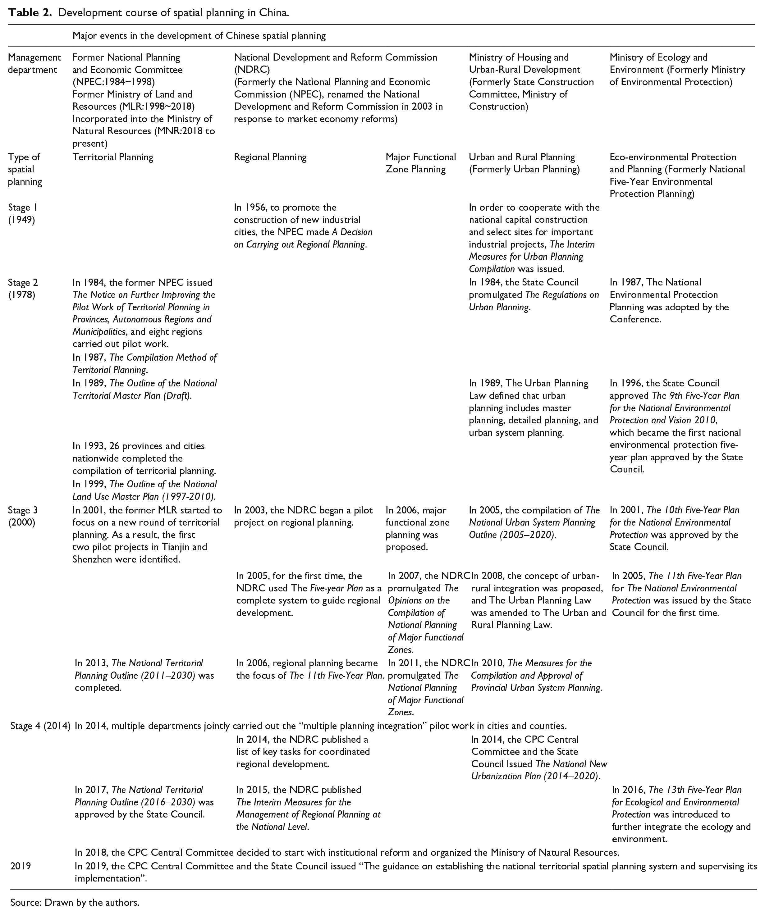
Source: Drawn by the authors.
The first stage was from 1949 to 1978, where spatial planning was mainly devoted to coordinating with the national capital construction. It was focused on physical spatial planning and design and aimed to implement the task of selecting sites for important industrial projects. It was essentially the continuation and concretization of The Five-Year Plans for National Economy and Social Development (Zhao, 2019). At the same time, to promote the construction of new industrial cities, the former State Construction Committee made A Decision on Carrying out Regional Planning (Niu, 2004). In 1956, the former State Construction Committee promulgated The Interim Measures for Urban Planning Compilation, which marked an important achievement in the legal construction of urban planning (Li, 2019).
The second stage was from 1978 to 2000, where the spatial planning system mainly consisted of territorial planning and urban planning. In this regard, the State Council approved The Outline of the National Land Use Master Plan (1997–2010) in 1999. By the end of 2000, the five levels of land-use planning—from the country to the town—were completed and began to be formally implemented (Zhao et al., 2019). During this period, the territorial planning made certain achievements in finding out the territorial resources in China (Niu, 2004). In terms of urban planning, to use urban space rationally, the State Council promulgated The Regulations on Urban Planning in 1984 and The Urban Planning Law in 1989, which defined that urban planning included master planning, detailed planning, and urban system planning in the form of legislation. Among them, the urban system planning is a kind of spatial planning unique to China, as it acts as a part of the “regional planning” and “territorial planning” functions (Zhou et al., 2017a).
The third stage was from 2000 to 2014. Here, the spatial planning system was mainly based on major functional zone planning, regional planning, territorial planning, urban and rural planning, and environmental protection planning (Figure 2) (Huang and Huang, 2019; Ye and Wang, 2019; Zhang, 2020; Zhang and Zhao, 2015; Zhao et al., 2019). After entering the 21st century, problems such as uncoordinated regional development, prominent urban-rural conflicts, serious environmental problems, and disorderly spatial development have become prominent. As a result, the spatial planning system has had to accelerate its transformation and development.
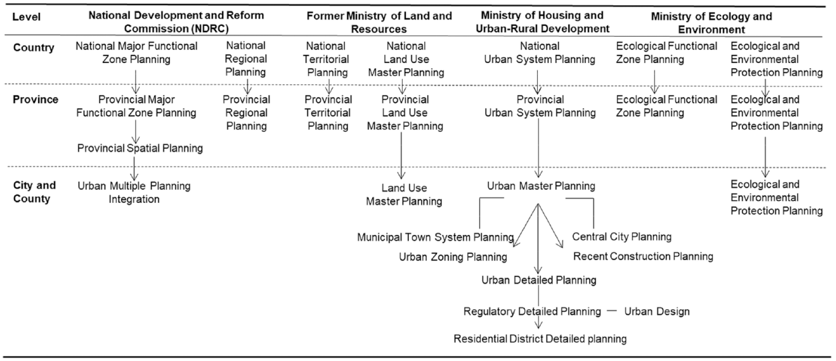
Spatial planning system of China before the reform of territorial spatial planning.
Along with the continuous improvement of the modern market economy system, there was the need to better macro-control various resources, protect the ecological environment and resolve regional development conflicts. In this regard, The 11th Five-Year Plan for National Economy and Social Development was adopted by the National People’s Congress in 2006, aiming to promote the compilation of “major functional zone planning”. This planning—a combination of “development” and “space” planning—is led and prepared by the National Development and Reform Commission (Zhang and Zhao, 2015). Regional planning was also the focus of The 11th Five-Year Plan for National Economy and Social Development (2006). Following the introduction of this plan, at least 39 national-level regional plans have been approved by the central government and supervised by the National Development and Reform Commission (Zhang, 2020). In addition to this, various provincial-level regional plans have also been approved, such as The Development Plan for the Yellow River Delta High-efficiency Eco-economic Zone, The Development Plan for the Guangxi Beibu Gulf Economic Zone, and The Development Plan for the Coastal Areas of Jiangsu etc.
During this period, the former Ministry of Land and Resources restarted a new round of territorial planning. In this regard, the pilot work for urban or regional territorial planning was launched in 2001. To date, it is running successfully (Huang and Huang, 2019). The National Territorial Planning Outline (2011–2030) and The National Territorial Planning Outline (2016–2030) were also successively promulgated in 2013 and 2017 on the basis of summarizing the local pilot experiences. To alleviate problems, such as the unbalanced urban-rural development caused by the dual urban-rural structure, The Urban Planning Law was amended to The Urban and Rural Planning Law in 2008, forming a five-level urban and rural planning compilation system of unban system planning, urban planning, town planning, township planning, and village planning. At the same time, in order to solve the ecological and environmental problems caused by rapid economic growth and heavy industrialization, China has been paying more attention to environmental protection and sustainable development. In this regard, it compiled a series of special environmental plans: The 11th Five-Year Plan for National Environmental Protection (2006) was issued by the State Council for the first time (Wang et al., 2021). In 2016, the name of The 13th Five-Year Plan was changed from National Environmental Protection Plan to National Ecological and Environmental Protection Plan to further integrate both the ecological and environmental aspects. At this point, the Chinese spatial planning system was transitioning from just coordinating “two plans” to coordinating “multiple plans”.
In the fourth phase (2014–2019), in order to deal with the problems of “overlapping planning responsibilities of different ministries”, “lack of effective connection between different planning contents”, “inconsistency of important spatial parameters such as protective space, development boundary and urban size determined by multiple planning” and “excessively long planning approval period” in the parallel stage of multiple planning, China began to explore the “multiple planning integration” but faced many challenges. Horizontally, various types of planning need more sufficient cohesion. Vertically, each department is self-contained and expanding, due to which a top-level design that can effectively and comprehensively coordinate the overall territorial space is quite lacking (Xu et al., 2017). Therefore, in 2014, four national ministries (the National Development and Reform Commission, the former Ministry of Land and Resources, the former Ministry of Environmental Protection, and the Ministry of Housing and Urban-Rural Development) organized the pilot projects of “multiple planning integration” and identified 28 pilot cities and counties nationwide. In September 2015, the CPC Central Committee and the State Council issued The General Plan for the Reform of the Ecological Civilization System to “build a nationally unified, interconnected and hierarchically managed spatial planning system with spatial governance and spatial structure optimization as its main contents”, and to complete “one plan and one blueprint for one region”. In 2017, according to The Provincial Spatial Planning Pilot Program, the provincial spatial planning pilot programs were launched.
After years of exploring “multiple planning integration”, in order to establish the seriousness and authority of “multiple planning integration” from the national level, the CPC Central Committee decided to start with institutional reform and organized the Ministry of Natural Resources in 2018, to promote the “multiple planning integration” of the major functional zone planning, territorial planning, and urban and rural planning. The objective behind this was to establish a unified territorial spatial planning system, as well as to have the ministry supervise its implementation.
The original work related to spatial planning in various administrative departments has been unified under the authority of the Ministry of Natural Resources. Other departments are no longer responsible for spatial planning preparation-related matters. However, there are still some departments whose work can support the current territorial spatial planning. For example, the National Development and Reform Commission still prepare the national and regional development plans. But this plan does not focus on spatial adjustment like the territorial spatial planning, it only conducts general guidance from the goal and strategic level. Horizontally, the territorial spatial planning has merged multiple plans into one plan, solving the problem of inconsistency of multiple plans; vertically it is only prepared by the Ministry of Natural Resources and conducted from top to bottom without different rules.
In May 2019, the CPC Central Committee and the State Council issued a programmatic document on territorial spatial planning, titled “The guidance on establishing the territorial spatial planning system and supervising its implementation”. The core meaning of the territorial spatial planning system can be briefly summarized as “one excellent and three highs”; “one excellent” refers to the priority of ecological civilization construction, while “three highs” refers to the comprehensive realization of high-level governance, promotion of high-quality development, and creation of high-quality life (Yang et al., 2019). According to this concept, adapting the requirements of ecological civilization construction and modernizing the governance capacity should be prioritized. In terms of content, it should shift from serving urban development and construction to the protection and utilization of natural resources. It should strive to carry out an all-factor planning for the entire territorial space and realize the unified management of natural resources. In terms of goals, it should comprehensively achieve high levels of governance, development, and quality of life (Zou, 2020). This reform is dedicated to the introduction of new objectives, implementation of integrated management, the strengthening of authority, simplification and efficiency, and the realization of “multiple planning integration, multiple examinations integration, and multiple certificates integration” in a policy.
System and contents of the Chinese territorial spatial planning
The Guidance clarified the positioning of territory spatial planning, stating that “territorial spatial planning is a guide for national spatial development, a spatial blueprint for sustainable development, and a basis for all kinds of construction activities from the aspects of development and protection”. It further clarified the basic framework of the territorial spatial planning system, including the “Five Levels and Three Categories” grading and classification compilation system and an operation system that comprises the four sub-systems of Compilation and Approval, Implementation and Supervision, Regulations and Policies, and Technical Standards (Figure 3) (Pan and Zhao, 2019).

The system framework of Chinese territorial spatial planning.
System framework of “Five Levels and Three Categories”
In accordance with the requirements of The Guidance, a “Five Levels and Three Categories” territorial spatial planning system shall be established. The “Five Levels” refers to five administrative levels (Country/Province/City/County/Town), while the “Three Categories” includes three kinds of planning (Master Planning/Detailed Planning/Relevant Sectoral Planning).
Focus and relationship of the “Five-level” planning
The Guidance states that national territorial spatial planning is the overall arrangement of the national territorial space, as well as the national policy and general outline of protection, development, utilization, and restoration of territorial space. The focus of such planning is on strategy. In this regard, provincial territorial spatial planning includes implementing the national territorial spatial planning, guiding the compilation of urban and county-level territorial spatial planning, and focusing on coordination. City, county, and town territorial spatial planning is the detailed implementation of the requirements, from higher-level governments to lower-level governments. It is the specific arrangements for the development and protection of this administrative area, focusing on implementation. The Guidance requires that lower-level territorial spatial planning should be subordinated to higher-level territorial spatial planning. It also states that a top-down system framework should be established for implementing the national development strategy.
Connotation and requirements of “Three-category” planning
The Guidance states that territorial spatial planning is a spatial and temporal arrangement for territorial spatial development and protection in a certain area, including master planning, detailed planning, and relevant sectoral planning. Master planning is divided into five levels, as explained in the previous section. Detailed planning is compiled at below the city and county levels. It refers to the implementation arrangements for specific land use, development, and construction intensity—a legal basis for carrying out territorial spatial development and protection activities, implementing territorial spatial use control, issuing planning permits for urban and rural construction projects, carrying out various constructions etc. A relevant sectoral planning refers to the special arrangement for spatial development, protection and utilization in specific areas (watersheds) and specific fields, reflecting specific function. The Guidance states that territorial spatial master planning is the basis for detailed planning and the foundation for relevant sectoral planning. The relevant sectoral planning should be coordinated with each other and connected with detailed planning well.
The relevant sectoral planning comprises special plans for coastal zones and natural reserves, and territorial spatial planning for lands across administrative regions or watersheds. It also includes sectoral plans for a certain area, such as transportation, energy, water conservancy, public service facilities, military facilities etc., and special plans for ecological protection, cultural relics protection, forestry and grassland etc. In the framework of the new territorial spatial planning system, promoting the synergistic compilation of relevant sectoral planning and territorial spatial master planning is an important measure to ensure the synergistic development of the special systems and the territorial spatial layout. Taking comprehensive transportation planning as an example, Zhang et al. (2020) proposed that it is necessary to establish a comprehensive transportation planning system, which is compatible, synergistic, and coordinated with the territorial spatial planning system. The levels and contents of the comprehensive transportation planning should be nuanced and go in-depth. Moreover, they need to be connected effectively with other sectoral planning and detailed planning to achieve high-quality development and construction (Figure 4). The comprehensive transportation planning and the territorial spatial planning work together and try to be coordinated during the preparation process which is the “simultaneous compilation”. They work together to complement, improve, and support each other, so that the two plans with different focuses maintain the basic consensus and the same goals in terms of content, facilitating the implementation of subsequent plans.

Comprehensive transportation sectoral planning system coordinated with the territorial spatial planning system.
Operation system
The operation system includes four sub-systems mentioned in Compilation and Approval, Implementation and Supervision, Regulations and Policies, and Technical Standards (Pan and Zhao, 2019). The Guidance requires that the planning compilation be strengthened by using a reflecting strategy, improving scientificity, and enhancing cooperation and operation. The Guidance also states that since “the one organizing the compilation is responsible for the implementation”, they need to clarify the main points of the compilation and management of various levels and types of territorial spatial planning as well. Moreover, it demands that in accordance with the principle of “the one approving the planning is responsible for the supervision”, a systematic review and filing needs to be established at each level (Table 3). Governments at each level will not only exercise relevant rights around four aspects of compilation, approval, implementation, and supervision, but will also be subjected to the constraints of relevant regulations, policies, and technical standards. The Guidance proposes to accelerate the construction of laws and regulations related to territorial spatial planning. Besides, according the requirements of “multiple planning integration”, the Ministry of Natural Resources—in conjunction with relevant departments—is responsible for building a unified system of technical standards for territorial spatial planning. Moreover, it is responsible for revising and improving the current status survey and land classification standards, as well as developing the compilation methods and technical regulations for various levels and types of territorial spatial planning.
Compilation and approval departments of the territorial spatial planning.
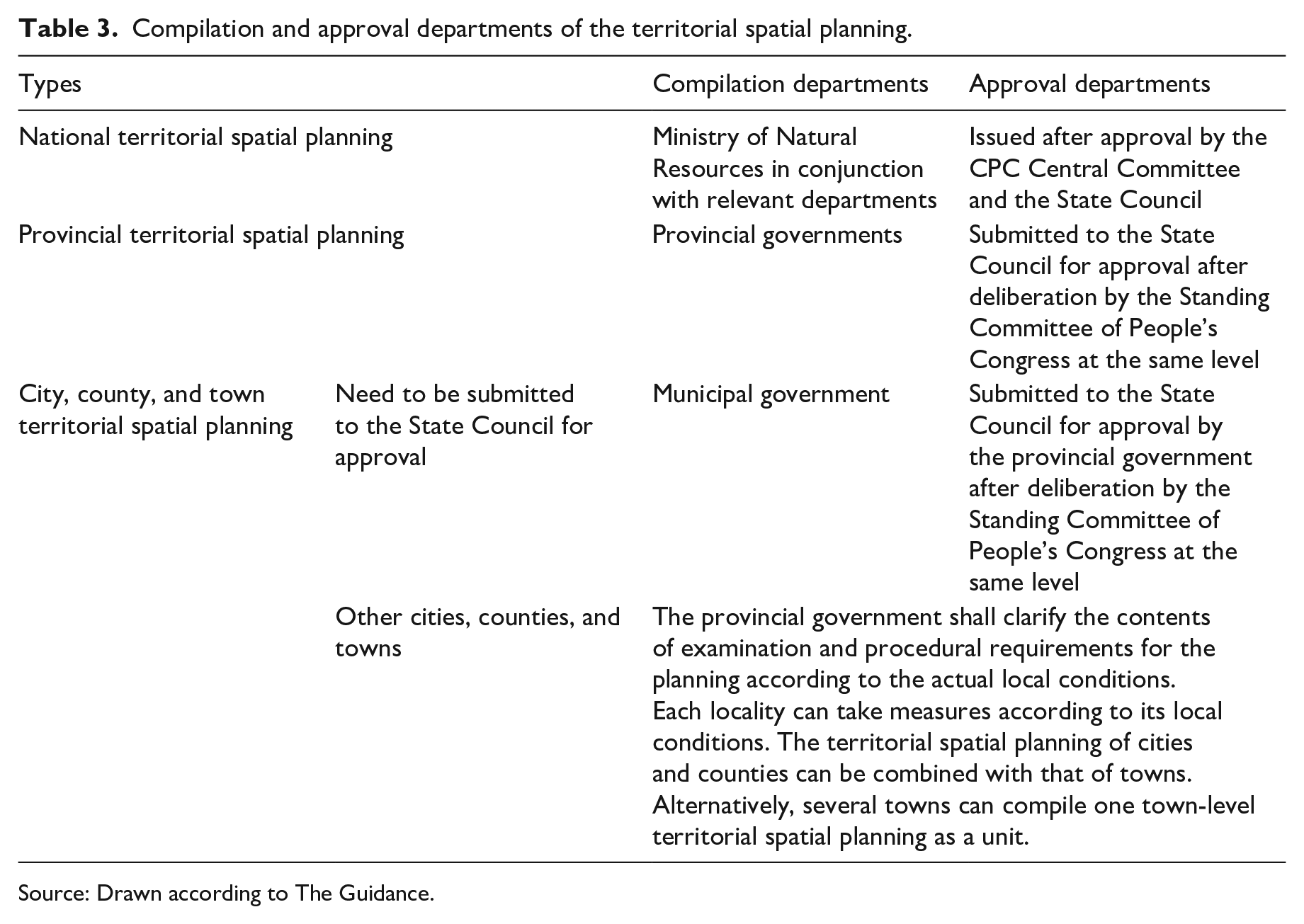
Source: Drawn according to The Guidance.
Recent key work
The Guidance points out that the territorial spatial planning is a new planning that integrates the major functional zone planning, land use planning, and urban and rural planning. According to the requirements of The Notice (Ministry of Natural Resources of the People’s Republic of China, 2019), we should carry out the compilation of territorial spatial planning in a comprehensive manner. This will help achieve the goal of “multiple planning integration”, coordinate all kinds of the existing spatial planning in this transition period, clarify the main points of examination and approval, and improve the way of examination and approval. Moreover, we should also focus on a series of the recent (and related) work, including the basic compilation work of planning, Double Evaluation (Evaluation of the carrying capacity of resources and environment and Evaluation of the suitability of territorial spatial development), the research on major issues, and the scientific assessment of three control lines—the ecological protection red line, permanent basic cultivated land line, and urban development boundary. Besides this, we must also focus on strengthening the cooperation with The Five-Year Plans for National Economy and Social Development, as well as the compilation of practical village planning (guided by “multiple planning integration”) and the simultaneous construction of the One Map implementation and supervision information system of the territorial spatial planning (Ministry of Natural Resources of the People’s Republic of China, 2019).
Among them, Double Evaluation and the delineation of three control lines are the basic and important elements to Chinese territorial spatial planning. In this regard, in January 2020, the Ministry of Natural Resources issued The guidelines for the evaluation of the carrying capacity of resources and environment and the suitability of territorial spatial development (trial) (hereafter “The Guidelines”) (Ministry of Natural Resources of the People’s Republic of China, 2020). The Guidelines propose that, according to requirements of The Guidance, evaluating the carrying capacity of the resources and the environment, as well as evaluating the suitability of territorial spatial development (referred to as “Double Evaluation”), is essential for compiling territorial spatial planning and improving the spatial governance. It is the reference basis for optimizing the pattern of territorial spatial development and protection, perfecting the orientation of the regional main functions, delineating three control lines, and determining the planning index for land and sea use. The workflow diagram of Double Evaluation is shown in Figure 5.
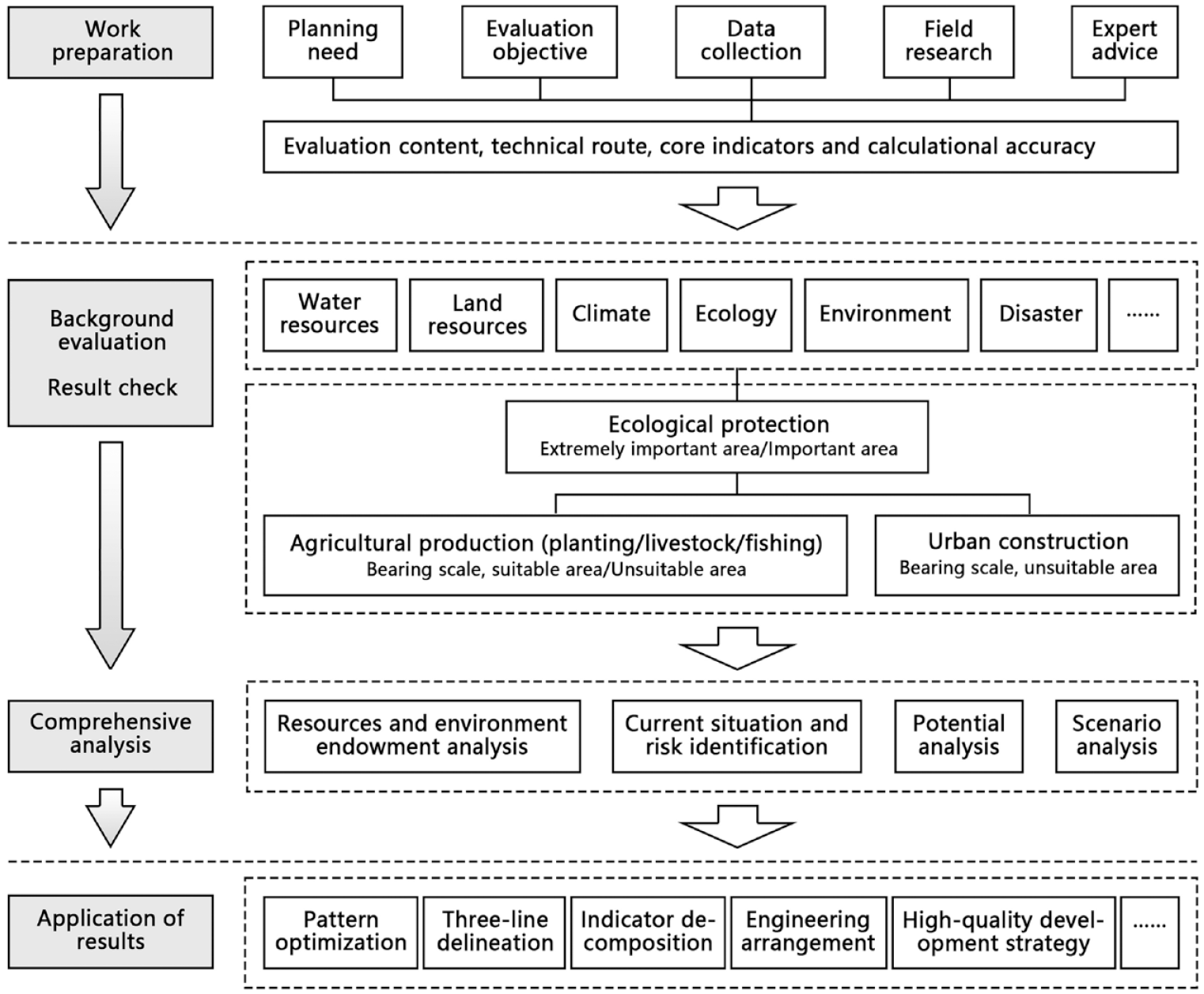
The workflow diagram of Double Evaluation.
International comparison of spatial planning development
Compared with many countries in the world, Chinese spatial planning system has developed relatively late. Some challenges that China is facing or may encounter could have been explored in international experience, so summarizing some common influencing factors that countries need to deal with in the development of their spatial planning systems and their different ways to deal with these factors may provide new ideas for the future development of Chinese territorial spatial planning. Besides, due to the great differences in administrative systems in various countries, it is of greater value to find some common factors at other aspects and methods to deal with these problems for comparative study. On comparing the Chinese experience with those of other countries, the paper discusses the content of current Chinese territorial spatial planning to be improved.
The main influencing factors of the evolution of the spatial planning system
The research proposes that the common factors that have a greater impact on the evolution of spatial planning in various countries can be summarized as five aspects: spatial resources, social factors, international events, environmental crises, and urban problems.
“Spatial resources” are the basis of spatial planning in various countries. Some countries, such as the Netherlands and Japan, are not very abundant in land resources and are often affected by natural disasters, so they are very concerned about the refined management of their land (Zhou and Shen, 2017; Wang and Yao, 2020).
In terms of “social factors”, more and more attention has been paid to humanism. Typically, Japan attaches great importance to the problem of population aging (Jiang et al., 2017).
“International events” mainly include two aspects. One aspect is the war. The post-war reconstruction needs of France, Germany, and some other countries accelerated the development of their spatial planning programs (Cai et al., 2017b). On the other hand, the economic crises have had a negative impact on spatial planning (Liu, 2019; Zhou and Shen, 2017) and the rapid development of globalization and informatization in recent years has also brought new challenges to the same.
“Environmental crises” mainly refer to the current global environmental problems faced by human beings. Global warming and various sudden natural disasters have brought contradictions and challenges to the spatial planning of various countries. The requirements of “carbon neutrality” and “carbon peaking” in recent years have also put forward new requirements for spatial planning (Xiong et al., 2021).
The term “urban problems” refers to the problems that countries encounter in the process of urban development, such as spatial disorderly sprawl, unbalanced regional development and various urban diseases. For example, in 1985, the over-concentration of urban functions in Tokyo, Japan, continued to intensify till the city had no choice but to resort to spatial planning (Jiang et al., 2017).
In addition, due to the strong policy attributes of spatial planning, the spatial planning systems of various countries are also greatly influenced by their own administrative systems.
Comparison of responses to different impacts in different countries
In response to the various impacts mentioned above, countries have taken active measures in spatial planning according to their national conditions. Due to the differences in the causes of the problems faced by various cities and the different political and legal systems on which the planning systems of different countries are based, there are different responses to these impacts in different countries. This section also discusses the enlightenments that China can get from other countries for its territorial spatial planning.
In response to the impact of tight spatial resources, the Netherlands has determined the main planning goals of intensive and efficient use of land resources in the early stage of spatial planning (Zhou and Shen, 2017). Faced with changes in spatial resources, countries pay more attention to the intensive use of urban built-up area rather than new space as the available resources decrease. Some countries (such as Germany, the Netherlands, France etc.) restrict or protect the development of space through legislation in actual planning. However, the main goal of the initial planning system of China was development and construction, so there was insufficient attention to the intensive use of land and space. The new territorial spatial planning system emphasizes all-region and all-factor planning, aiming at the overall management of natural resources and intensive development. However, at present, the main law of territorial spatial planning has not been promulgated yet. Legislative process needs to be accelerated.
In response to the influence of social factors, countries emphasize the concept of “people-oriented” and attach importance to the process of spatial planning. The United States, the United Kingdom and France have gradually focused their attention on the bottom-up planning process and the concept of space governance has also shifted from control management to negotiation. For example, the rise of the civil rights movement from the 1960s to 1980s contributed to the development of community planning in the United States (Cai et al., 2017a); France paid more attention to fair and green development and social solidarity in its 2008 reforms and Japan proposed the creation of cities with social participation and social support in the seventh national comprehensive plan (Jiang et al., 2017). China emphasizes high-level governance, high-quality development and high-quality life in this spatial planning reform, which also involves the implementation of the “people-oriented” concept. For example, many cities in China, such as Shanghai, proposed taking the 15-minute community life circle (15-minute walking range) as the basic unit of community public resource allocation and social governance, which reflects the high attention to people’s needs and refined governance. However, it still needs to be strengthened in terms of public participation. Implementing public suggestions and feedback mechanism in planning at different levels, especially at the local level, may be an important focus in the future territorial spatial planning in China.
In response to the impact of international events, several unexpected international events have made countries around the world pay more attention to flexibility and comprehensiveness when formulating new spatial planning strategies. For example, in response to the economic crises, the Netherlands adjusted the original spatial planning system that emphasized rules and regulations and began to vigorously streamline administration and delegate powers to carry out new spatial reforms (Needham, 2005; Van der Valk, 2002). Although China’s administrative system is quite different from that of most other countries, we can also learn from their problem-solving ideas. In this round of planning reform, China has highlighted the modernization of governance capabilities, streamlining the administration and increasing efficiency as well as promoting planning flexibility. However, the clarity of the “five-level and three-category” planning system and the strong top-down management and control characteristics pose a test for the flexibility of space governance. On the premise of ensuring the leading role of national and provincial planning, the planning requirements of cities and counties that have reached a certain level of development may be moderately relaxed.
In response to the environmental crises, countries have emphasized sustainable and green development and added contents that consider future uncertainties in spatial planning. For example, Germany added the concept of “addressing climate change and shaping the energy revolution” in its latest strategic plan in 2016 (Qiang et al., 2020). The United Kingdom and the United States are exploring key urban planning practices, taking managing climate change as the goal of planning and urban development. China has made “priority of ecological civilization construction” as the core theme of this territorial spatial planning reform, which reflects China’s high regard for the global environmental crises and its firm determination to ensuring efficient ecological civilization construction and governance. In the future, in addition to strengthening the requirements for ecological environment protection, it is also necessary to increase the management means matched with spatial planning to promote the implementation of objectives of “ecological civilization construction”.
In response to urban problems, countries have put forward specific planning concepts, policies, and even regulations according to their actual conditions. For example, in response to the phenomenon of urban sprawl, the United Kingdom promulgated the 1932 Urban and Rural Planning Act to extend local governments’ administrative management in land use from urban space to urban and rural space (Luo et al., 2017). In the mid-20th century, in response to the problem of unbalanced regional development, France continuously strengthened the coordination role of regional planning and promoted the development of non-capital areas through legislation. Japan has set up international and local “dual development goals” in its new plan in 2015 and encouraged residents to participate in local construction to avoid population agglomeration to high-density areas to solve the problem of population and resource imbalances (Jiang et al., 2017). In order to cope with the coordinated development of regions, China has proposed metropolitan area territorial spatial planning and promulgated relevant regulations. However, due to the limitation of administrative units, there are still some barriers in joint planning across administrative units, which need to be further explored and improved in practice. In fact, the complexity of the urban system has brought about the diversification of urban problems. China and other countries need to continuously accumulate experience in the practice of urban development to improve the ability and efficiency of solving urban problems.
Summary and conclusion
Chinese spatial planning has gone through the co-existence stage of “multiple planning”, such as territorial planning and urban and rural planning. Following this, it began exploring “multiple planning integration” in 2014. Then in 2019, the CPC Central Committee and the State Council issued the programmatic document The Guidance to lead the reform of territorial spatial planning. The study reviews the evolution of spatial planning in six different countries. Then it describes the development course of the Chinese spatial planning system from 1949 to 2019 in four stages and introduces the main contents of the current Chinese territorial spatial planning. The study also compares the development process of spatial planning in various countries and summarizes the core influencing factors into five aspects: spatial resources, social factors, international events, environmental crises, and urban problems. Then, it compares the coping strategies of various countries and discusses the enlightenments of these coping strategies to China.
The study believes that after decades of development, China has formed its own unique territorial spatial planning system. From the perspective of the compilation and management system, the top-down five-level planning system of “Country/Province/City/County/Town” is very clear, and the characteristic of strong control under the centralized administrative system is obvious. This reform focuses on an all-factor planning of the whole area, aiming to realize the integrated management of natural resources. It emphasizes the priority of ecological civilization construction, which is centered around the concept of “sustainable development”. It pays great attention to the modernization of governance capacity and emphasizes formulating order regulations regarding territorial spatial utilization based on national interests and public interests. This helps to take a holistic approach to allocating and using spatial resources, streamlining the administration and increasing efficiency. It also emphasizes high-quality development and high-quality life, aiming to improve the level of urban development and quality of people’s life.
The complex process of the change in Chinese spatial planning is accompanied by progress with the times and constant self-reflection. Today’s territorial spatial planning reform has a staged progress but there are still some issues worth paying attention to. For example, difficulties still exist in the integration of the thinking methods and internal logic of various spatial planning types in the “multiple planning integration”. The construction of the One Map system, which is the work platform of “multiple planning integration” and also used for planning implementation and supervision, has problems such as difficult connection between different spatial standards and inconsistent spatial coverage in different planning. The top-down conduction system poses a great challenge to the flexibility of space governance, especially in the delimitation process of urban development boundaries since the contradiction between the bottom line and development has always existed. The backbone law of the territorial spatial planning has not been promulgated yet and legal support needs to be strengthened. All these factors need to be optimized and perfected in terms of spatial cognition, management systems, and implementation goals etc. The construction of China’s territorial spatial planning system is still in constant exploration and progress. This paper introduces China’s experience in the field of spatial planning and through the research and comparison of international experience, it is expected to provide China or countries with similar development characteristics to China with suggestions for future spatial planning system adjustment and improvement.
Footnotes
Declaration of conflicting interests
The author(s) declared no potential conflicts of interest with respect to the research, authorship, and/or publication of this article.
Funding
The author(s) received financial support from The National Natural Science Foundation of China (Number 52178049) for the research, authorship, and/or publication of this article.