
Abstract
This study aims to formulate a local instruction theory (LIT) utilizing ethnomathematics and technology-based realistic mathematics education (RME) to support students’ spatial abilities. The LIT was constructed employing a design research approach, consisting of three stages: the experiment preparation, teaching experiment, and retrospective analysis. The participants were 88 junior high school students and two pre-service mathematics teachers. Data were collected through observation, interviews, and a questionnaire, which were then analyzed descriptively. The findings indicated that the LIT involved several activities. These included identifying the spatial features of Indrapatra Fort, which resembles a cylinder and a half-sphere, determining distances and cardinal directions related to these features, planning a route for a visit within the Indrapatra Fort area and writing a narrative about the visit route. Students also observed illustrations of spheres and half-spheres using GeoGebra, determined the scale for the miniature dome of Indrapatra Fort, and summarized the steps needed to create a miniature model-of the fort, which consists of a cylinder and a half-sphere. Students responded positively to the learning. Consequently, educators are encouraged to employ LIT through RME to cultivate students’ spatial ability.
Introduction
An intriguing aspect of human cognitive intelligence that can enhance student performance is spatial reasoning skill (Buckley et al., 2018). Individuals with strong spatial skills can make changes by perceiving or envisioning, articulating ideas, and accurately describing elements such as colors, lines, shapes, spaces, and relationships (Armstrong, 2009). Furthermore, spatial reasoning skill is essential for mastering other professional skills (Lubinski, 2010). Given its importance to everyday life, spatial reasoning supports students in activities, such as playing block games, understanding positions on a sports field, and navigating spaces effectively. Importantly, spatial reasoning plays a crucial role in STEM fields (Wai et al., 2009).
Spatial reasoning in real-world contexts is numerous and varied (Atit et al., 2020; Uttal & Cohen, 2012). Fundamentally, spatial reasoning encompasses spatial visualization, mental rotation, and spatial orientation (Ramful et al., 2017). However, students’ proficiency in spatial reasoning remains suboptimal, as they often lack detailed exploration when responding to problems related to spatial reasoning (Haciomeroglu, 2016; Hawes et al., 2015). Consequently, there is a need for teachers to enhance students’ spatial skills. Several studies have designed learning activities focusing on spatial orientation (Hegarty et al., 2002; Lowrie & Logan, 2007). One learning approach oriented toward applying mathematics in everyday life to develop students’ spatial skills is Realistic Mathematics Education (RME).
RME conceives mathematics as a human activity. RME aims to facilitate learning by presenting problems within the context of the real world or situations imaginable by students (van den Heuvel-Panhuizen & Drijvers, 2020). Treffers (1987) proposed that in the RME learning approach, students engage in horizontal mathematization, which involves transforming real problems into mathematical problems, and vertical mathematization related to the process of mathematics. Mathematics learning through RME employs contextual problems as a starting point to guide students progressively toward the learning objectives through a process of mathematization, utilizing models and strategies they develop independently. To implement RME effectively, it is essential to design a detailed lesson plan called Hypothetical Learning Trajectory (HLT) as suggested by Simon (1995) because the HLT enable teachers to tailor instruction to meet diverse students’ needs, and continuous evaluation during the learning process helps teacher to identify gaps and adjust teaching strategies accordingly (Simon, 1995).
The instructional task comprises a sequence of systematically designed activities and tasks to help students achieve the intended learning objectives (Fauzan et al., 2018; Simon, 1995), and it can be applied using local contexts, such as students’ traditional and otherwise everyday experiences. Integrating such contexts enhances student engagement and reinforces the view that mathematics is more than a set of abstract rules but a discipline that originates from and is grounded in real-life practices. From this perspective, mathematics is viewed as a human endeavor that evolves historically, culturally, socially, and even politically (Albanese & Perales, 2020; D’Ambrosio, 2016). Mathematics has a deep connection to culture, spanning ancient times, and is intricately woven into numerous human activities (Young, 2017). Consequently, mathematics is regarded as a cultural product (Sardjiyo & Pannen, 2005), termed ethnomathematics in the context of mathematics learning.
Aceh, one of the provinces in Indonesia, has numerous cultural elements to serve as contextual foundations for learning mathematics. Indrapatra Fort in Aceh holds significance as a cultural heritage site, but suffers from neglect due to a lack of proper maintenance or preservation efforts from relevant authorities. The lack of awareness about the existence of Indrapatra Fort existence emphasizes the need for educators to incorporate cultural preservation through mathematics education. Integrating the context of Indrapatra Fort into instruction enables students to engage with cultural heritage while enhancing their spatial orientation skills. Therefore, teachers are encouraged to implement mathematics instruction using creative and innovative strategies, including the contextualization of Fort Indrapatra.
Several previous studies on learning trajectory (LT) related to ethnomathematics have been conducted. For instance, an LT for number pattern using the Barathayudha war story and Uno Stacko (Risdiyanti & Prahmana, 2020), an LT for circle in the context of a tambourine (Juniarti et al., 2022), an LT based on Indonesian shadow puppets and the Mahabharata story (Risdiyanti & Prahmana, 2021), an LT on reflection using Riau batik motifs (Filda & Armiati, 2023), an LT on transformation geometry to enhance spatial ability (Yuliardi & Rosjanuardi, 2021), and a game-based LT for scale and proportion (Wijaya et al., 2021). However, research exploring an LIT through RME based on ethnomathematics to support students’ spatial abilities involving the concepts of scale and proportion is limited.
The incorporation of technology into learning aligns with the demands of twenty-first-century education. Its use in learning mathematics has been shown to improve the quality of learning and foster student interest (Bray & Tangney, 2017; Hillmayr et al., 2020; Olsher & Thurm, 2021). Technology helps students explore, discover, and develop mathematical concepts mathematical concepts (Hoyles et al., 2013) and it supports their understanding (Hegedus & Roschelle, 2013). In this study, GeoGebra and Google Earth were employed as technological tools. Hence, the objective is to develop an LIT through ethnomathematics and technological-based RME to support students’ spatial ability, specifically focusing on the concepts of scale and proportion, and to analyze students’ responses to the LT. Thus, this study was guided by a research question: How is the local instruction theory through ethnomathematics and technological-based realistic mathematics education to support students’ spatial ability?
Literature review
Realistic mathematics education (RME)
RME is a learning approach developed by Freudenthal (1983). It is grounded on Hans Freudenthal's view that mathematics is a human activity (Freudenthal, 1983; Gravemeijer, 1994). A key feature of RME is the incorporation of situations that contain rich “realistic” elements. While “realistic” in the sense of real-world contexts is important within RME, the term carries a broader meaning, referring to problem situations that students can meaningfully imagine and engage with. Gravemeijer (1994) introduced three main principles of RME: guided reinvention and progressive mathematization, didactic phenomenology, and self-developed models. These were further developed into six principles: activity principle, reality principle, level principle, intertwinement principle, interaction principle, and guidance principle (Van den Heuvel-Panhuizen & Drijvers, 2020). Among these, the level principle is closely related to the instructional sequence.
The level principle emphasizes that, in learning mathematics, students must progress through various levels of understanding. Gravemeijer (1994) proposed a model comprising four levels of thinking: situations, models of, models for, and formal knowledge. The situation level involves mathematical activities related to everyday life or problems imaginable by students, providing rich opportunities for mathematization (Gravemeijer, 1994; Gravemeijer et al., 2017; Gravemeijer & Stephan, 2002). Models are critical in bridging informal, context-based understanding, and formal mathematics. To fulfill this role, models must evolve, transitioning from “models of” a specific situation to “models for” a range of analogous situations—a transition described by Streefland (1985, 1993) and further elaborated by Gravemeijer (1994) and Van Den Heuvel-Panhuizen (2003). At the formal knowledge level, students can articulate mathematical generalizations or conclusions. Thus, to support the effective implementation of RME, it is necessary to develop an instructional sequence in the form of an HLT, which is refined over several cycles to produce an LIT.
Hypothetical learning trajectory and local instruction theory
Simon (1995) argued that an HLT represents a key aspect of pedagogical reasoning involved in teaching mathematics for understanding. HLT consists of three main components: learning objectives, tasks that facilitate students’ progression toward those objectives, and hypotheses concerning the thinking processes or strategies students may employ in carrying out the tasks (Clements et al., 2011; Simon, 1995; Simon & Tzur, 2004). In this context, the teacher's role is to anticipate the collective mathematical development within the classroom community and predict how students’ understanding will evolve through active engagement in the learning process (Cobb, 2000; Cobb & Bowers, 1999; Simon, 1995). The design research approach enables researchers to iteratively test and revise the HLT until the desired learning objectives are achieved.
In this study, the HLT was developed through three stages. Preparing for the experiment is the first stage, which involves constructing the HLT based on initial observations of students’ conditions and characteristics. Next, the teaching experiment stage was conducted to examine the alignment between the initial assumptions and students’ actual classroom responses. The final stage, retrospective analysis, aimed to evaluate and revise the HLT using empirical data gathered during instruction. This stage enabled researchers to reflect on and refine the HLT for better effectiveness, ultimately developing a local instructional theory (LIT).
LIT is a descriptive and logically justified learning path comprising a coherent set of learning activities for a specific topic (Gravemeijer, 2004; Gravemeijer & Cobb, 2006). Gravemeijer (2004) argued that LIT is a description and logical justification of a designed learning trajectory, comprising a series of learning activities focused on a specific topic. Gravemeijer (1999) highlighted two fundamental distinctions between HLT and LIT: (1) HLT addresses a limited number of learning activities, whereas LIT encompasses the entire sequence of instruction, and (2) HLT is envisioned within a specific classroom setting, while LIT provides a general framework that informs the development of HLTs for particular learning environments. Hence, the primary differences between HLT and LIT lie in the scope of the learning duration and the situational context in a particular classroom.
Spatial learning through ethnomatematics and realistic mathematics education
All students should be encouraged to develop spatial abilities, as these are essential for understanding geometric relationships and properties and solving mathematical and real-life problems (National Research Council, 2005). Students taught through RME approach showed greater improvements in spatial abilities and a higher percentage of successful learners compared to those taught with conventional methods. Arista et al. (2022) identified students’ difficulties in solving mathematical problems related to scale and proportion, often resulting in errors.
Ethnomathematics studies and integrates mathematical ideas, methods, and techniques practiced and developed by socio-cultural or cultural communities (D’Ambrosio, 2007, 2016; Rosa & Orey, 2016). This field also unveils the intricate relationship between culture and mathematics (Balamurugan, 2015). As a culturally rich and diverse nation, Indonesia holds significant potential to transform mathematics education by aligning it more closely with students’ real-life experiences and cultural backgrounds (Prahmana & D’Ambrosio, 2020). Aceh, one of the provinces in Indonesia, has numerous cultural elements to serve as contextual foundations for learning mathematics, such as historical buildings, traditional Acehnese houses, and traditional dances, each possessing unique and distinctive forms (Irawan, 2023). In mathematics learning, teachers guide students to explore the route to Indrapatra Fort using concepts such as scale, proportion, and spatial orientation. Integrating the context of Indrapatra Fort into instruction enables students to engage with cultural heritage while enhancing their spatial orientation skills.
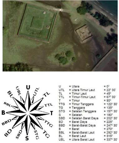
Indrapatra Fort is a historical fortress in Aceh utilized from the Hindu to the Islamic era. During the reign of Sultan Iskandar Muda and Admiral Malahayati, it served as protection against various threats from the Malacca Strait. The structure is a relic from the 7th century AD, reflecting the introduction of Hinduism to Aceh (Regional Office for Cultural Properties Preservation in Aceh Province, 2005). Initially employed as both a residence for the royal family and a site for religious rituals in the early days of Hinduism in Aceh, it was transformed into a fortress in the sixteenth century during the Islamic sultanate, characterized by its horseshoe-shaped design, primarily serving as a cannon and armory (Zainuddin, 1961). Nimba (2019) posted images and explanation of Indrapatra Fort at https://acehtourism.travel/blog/situs-sejarah-tsunami/indra-patra-dan-kejayaan-hindu-di-aceh-besar/.
Method
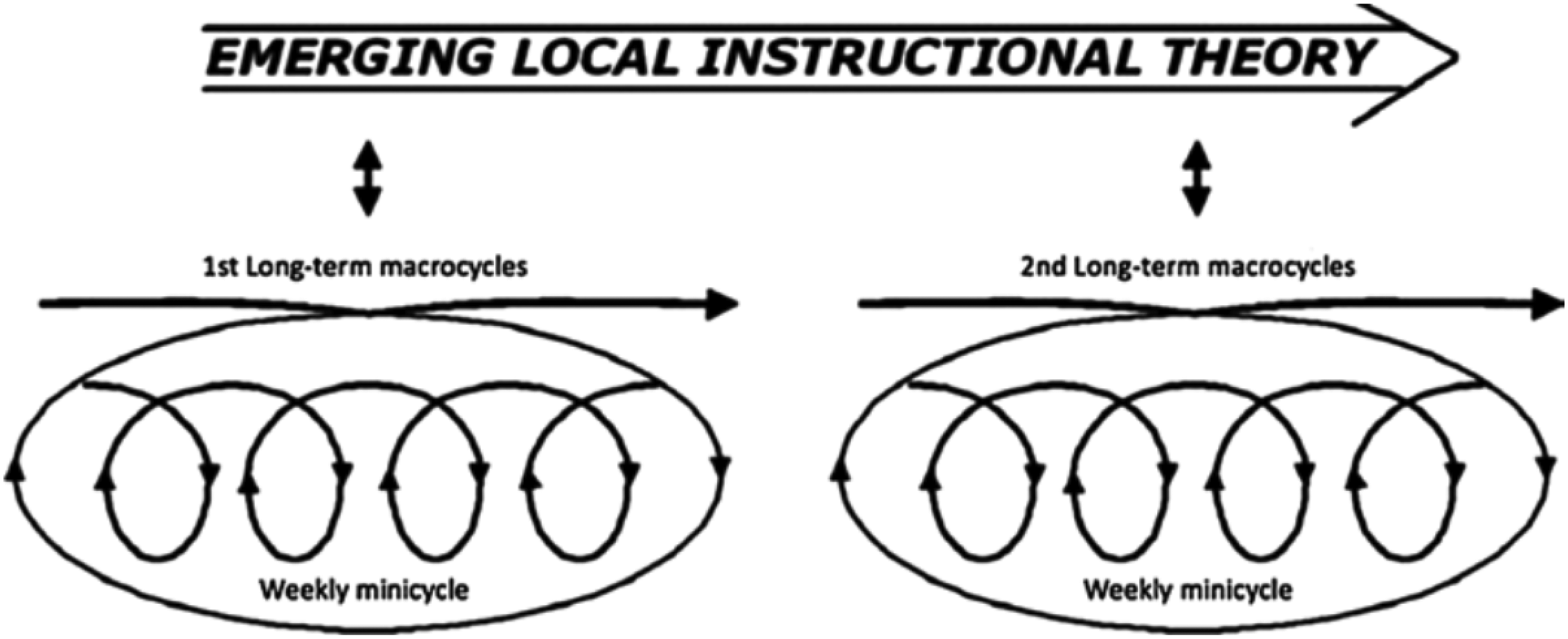
This study employed Gravemeijer and Cobb (2006) design research approach. Gravemeijer and van Eerde (2009) argued that the design research aims to develop an LIT through collaboration between researchers and teachers, ultimately enhancing the quality of learning. There are two crucial aspects related to design research: HLT and LIT. The design research comprises three stages: the experiment preparation, the teaching experiment, and retrospective analysis (Gravemeijer & Cobb, 2006). In other words, the HLT cycle in design research occurs repeatedly through these three stages. This HLT cycle concludes when the learning objectives are achieved and the answers to the research questions are obtained. However, they can be repeated if the learning objectives have not been met. Figure 1 presents the design research cycle proposed by Gravemeijer and Cobb (2006).
Cycle of design research.
At this stage, the researchers developed activities fostering students’ conjectural thinking through the HLT. After the validation and revision process, the HLT developed into an LIT (Cobb et al., 2003; Gravemeijer & Cobb, 2006). LIT consists of three main components: learning objectives, tasks designed to promote student learning toward those objectives, and hypotheses about the thought processes or strategies that students may use while completing the tasks (Clements et al., 2011; Simon & Tzur, 2004). The researchers conducted classroom observations and interviews with the teacher to understand the students’ initial conditions and abilities. Gravemeijer and Cobb (2006) argued that the “experiment preparation” stage aims to design the LIT. Before designing the LIT, a literature review was conducted, exploring books, journals, and articles on project-based scale and proportion learning to design the HLT. HLT aims to represent the students’ learning process, starting from their initial knowledge to the achievement of the learning objectives.
The steps to create HLT involve designing activities to assist students in gaining knowledge and achieving learning objectives. Subsequently, learning tools such as Lesson Plans and Student Worksheets were designed as references for implementing HLT. The HLT, once validated and declared valid, can be tested in the first trial class, referred to as HLT 1.
Teaching experiments
The teaching experiment stage aims to test the previously designed HLT from the “experiment preparation” stage to refine it further. The trial was conducted based on the designed HLT and implemented concerning the validated lesson plans and student worksheets. The validated HLT was then tested in the second trial class, referred to as HLT 2. If any obstacles arose during HLT 2, the HLT was further tested in the third trial class, referred to as HLT 3. Based on the trials, the analysis aimed to evaluate the extent to which the activities in the HLT were carried out in the learning process and their impact on student understanding.
The subjects in this study were preservice teachers (PTs) and Year 8 students from public junior high schools in Banda Aceh, Indonesia. The PTs involved in this research were two mathematics education students (AR and SN) from a local university in Aceh, Indonesia. Both AR and SN had undergone Micro Teaching and Introduction to the School Course (known as PLP). The researchers served as supervisors, guiding the PTs throughout all three stages of the research. PTs assumed the role of teachers during the teaching experiment and retrospective analysis stages.
AR and SN conducted the first trial as a pilot class, with class VIII-1 divided into two rooms, each room consisting of 15 students. The learning sessions in the two rooms were conducted simultaneously. Subsequently, the second trial of the HLT cycle was conducted by AR in class VIII-4, attended by 30 students. However, only 28 students submitted the questionnaire, and the third trial was conducted by SN in class VIII-3, also attended by 30 students. While AR and SN conducted their teaching sessions, the researchers observed each activity and collected necessary data throughout the learning process.
Retrospective analysis
Retrospective analysis represents the final stage in design research. This analysis utilized data collected during the research, including student answer sheets, video recordings, field notes, observation sheets, and student response questionnaires. Additionally, retrospective analysis involved interviews with students and discussions with teachers. During this analysis, certain aspects of the HLT were retained, while others were reduced. Retained elements were those believed to positively influence student understanding, whereas reduced components were considered ineffective in achieving learning objectives. Therefore, the cycle in design research occurs repeatedly until the research objectives are met. In this study, the research objectives are considered achieved if the designed HLT effectively supports students’ spatial abilities, as aligned with the conjectures outlined in the HLT. Furthermore, the HLT is deemed supportive if students respond positively to its learning activities.
The student response questionnaire was then administered after all learning activities were completed. It gathered students’ feedback on the implementation of learning, including components such as ethnomathematics-based student worksheets, the learning atmosphere, and the teaching methodology (see Table 1). The questionnaire consists of two options, positive and negative, such as satisfied/not satisfied, new/not new, interested/not interested, and clear/not clear.
Components of student perception questionnaire.
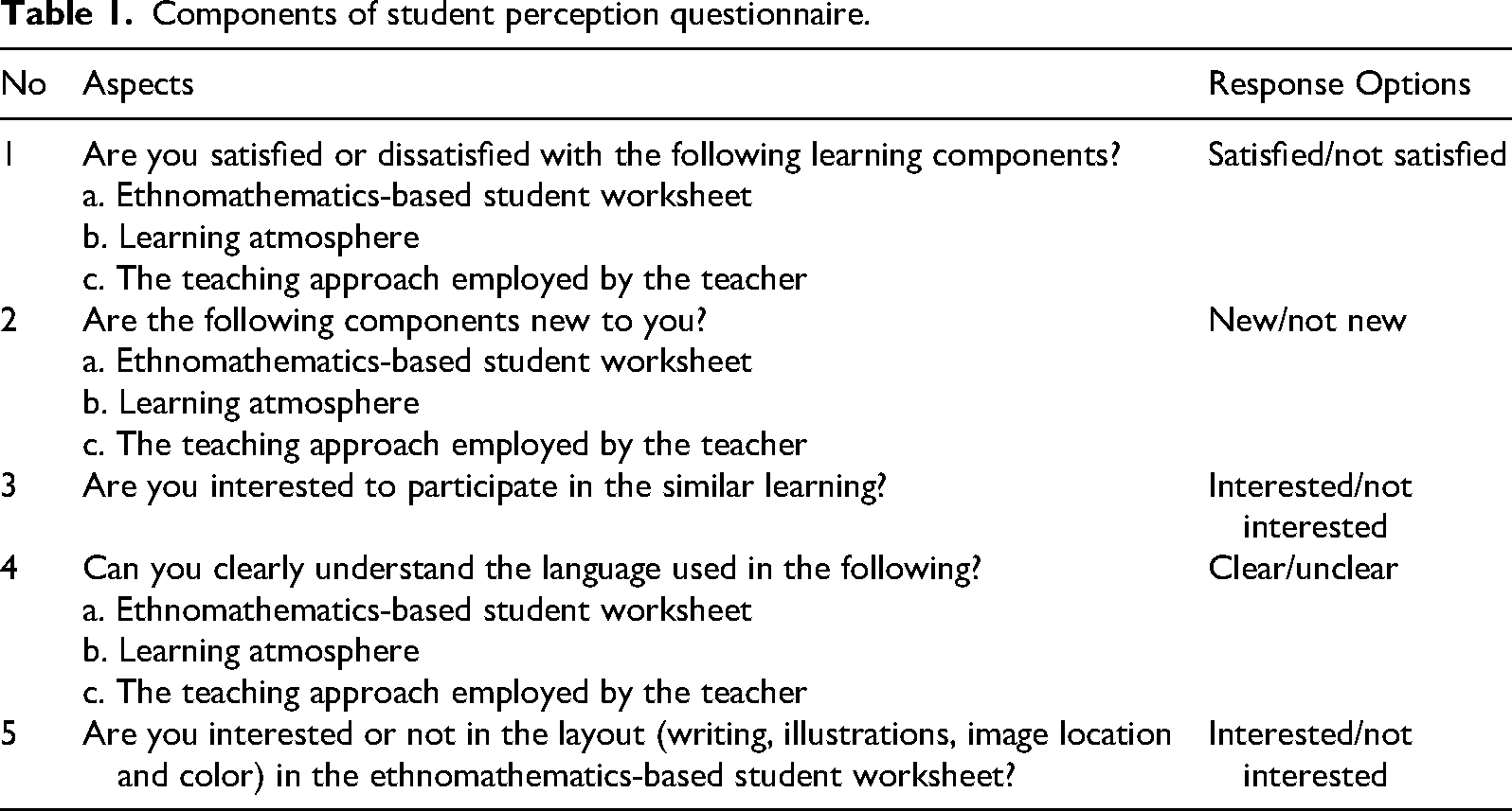
Components of student perception questionnaire.
Descriptive statistics were used to analyze student response data, with the percentage of student responses calculated using the following formula.
Student responses are considered positive if 80% or more of students express satisfaction and find the content to be both novel and clear. This assessment includes components such as ethnomathematics-based student worksheets, the learning atmosphere, and the teaching methodology. Positive responses also indicate a willingness to participate in subsequent learning activities, especially those based on ethnomathematics, and a favorable impression of the student worksheet's visual elements (such as writing, illustrations/images, image placement, and color). Conversely, if less than 80% of students express dissatisfaction, perceive the content as unoriginal or unclear, show a lack of interest, and find the visual aspects unengaging, these responses are deemed unfavorable.
Research results are presented based on the stages of Design Research as outlined by Gravemeijer and Cobb (2006), namely the experiment preparation, the teaching experiment, and retrospective analysis. Design research in this study was carried out through cycles to produce an LIT.
Cycle 1: Hypothetical learning trajectory 1 (HLT 1)
HLT 1: Preparing for the experiment
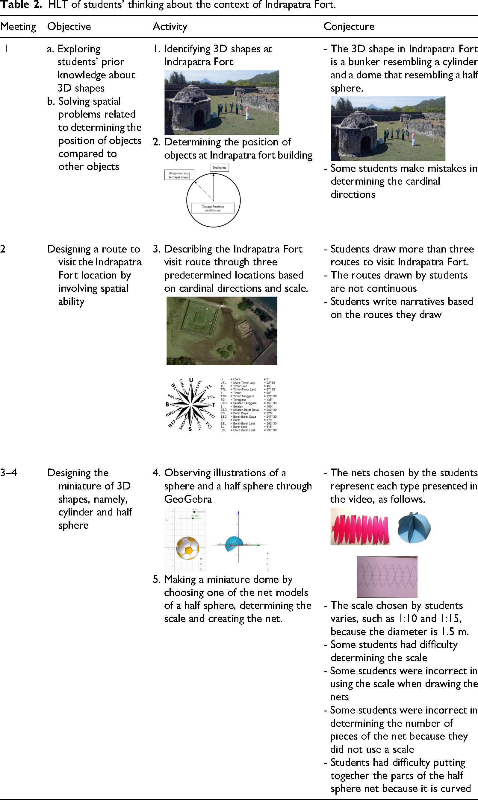
In the experiment preparation stage, researchers reviewed references, observed the Indrapatra Fort building, observed the classroom and interviewed with the teacher to understand the students’ initial conditions and abilities. Then, researchers formulated an HLT about a series of learning activities for four sessions. The initial meeting focused on positioning objects within the Indrapatra Fort building. The second meeting involved designing a visit route at Indrapatra Fort, incorporating spatial ability and the concepts of scale and proportion. The third and fourth meetings were dedicated to creating a miniature model of the Indrapatra Fort, representing it in the form of a cylinder and a half sphere within the contextual framework of the historical site. Figure 2 illustrates the HLT for spatial learning of scale and proportion.
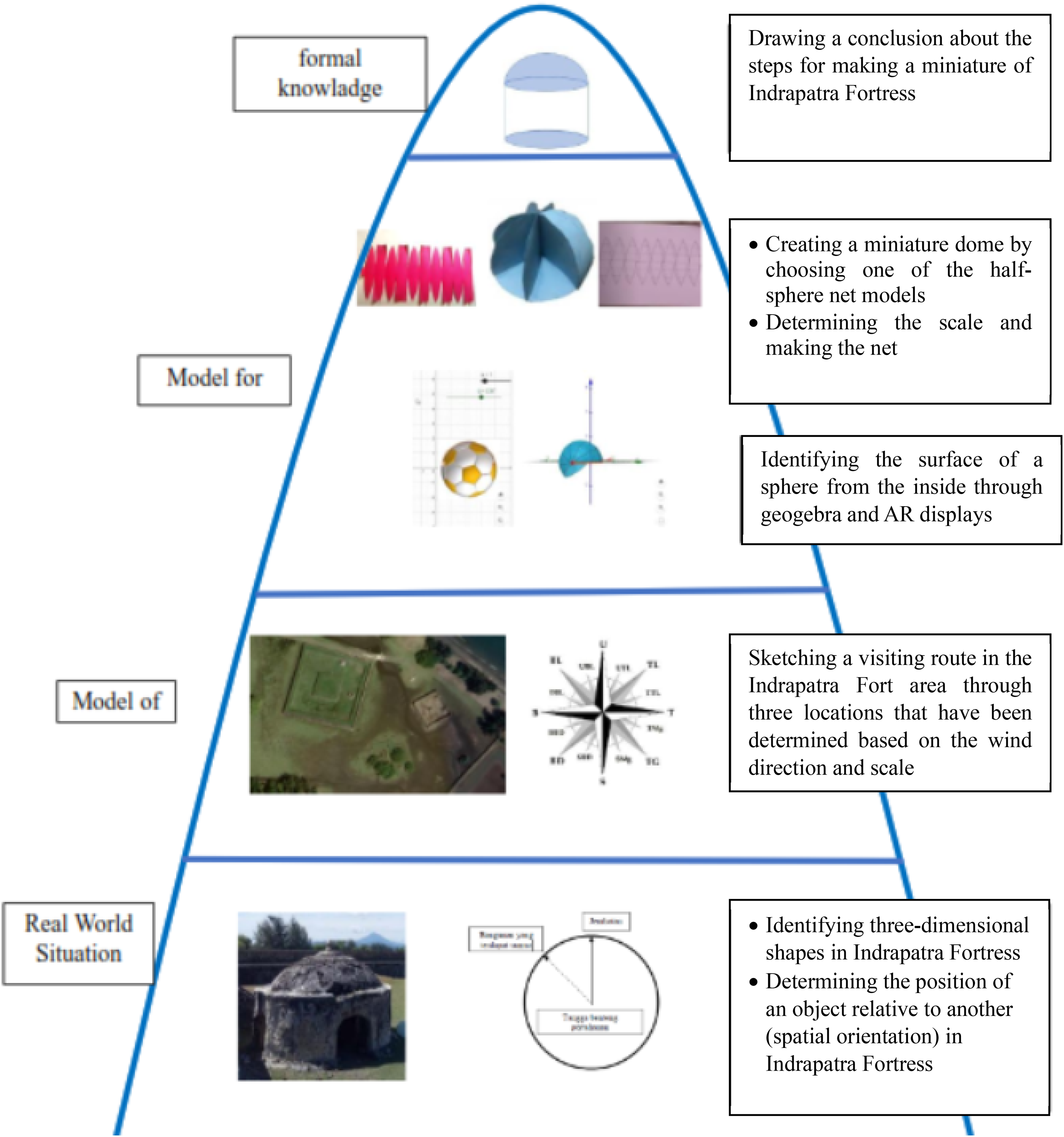
HLT 1 for spatial learning on scale and proportion with the context of indrapatra fort.
A detailed description of the HLT in Figure 2, along with the conjectures regarding students’ thinking processes, is presented in Table 2. This HLT, which has met the validity criteria, is subsequently referred to as HLT 1 (Raisa et al., 2024).
HLT of students’ thinking about the context of Indrapatra Fort.
The validated HLT 1 was implemented concurrently in classroom VIII-1. The students were divided into two classes, VIII-1a and VIII-1b, each comprising 15 students. SN led the activities for the first and second meetings in class VIII-1a, focusing on identifying spatial structures in Indrapatra Fort, determining the positioning of objects within the fort, and sketching routes in the Indrapatra Fort area. Meanwhile, AR led class VIII-1b for the third and fourth meetings, which involved creating a miniature of Indrapatra Fort.
In class VIII-1a, SN initiated the learning by exploring students’ prior knowledge of scale and proportion they had learned in elementary school. SN motivated students by discussing how scale and proportion apply to daily life, such as asking, “What is the distance between your house and school?” Following this, SN stated the learning objectives and presented the Indrapatra Fort building through Google Earth, emphasizing the main fort and the defense fort. The students focused on identifying a specific building in Indrapatra Fort, known as the Fort Bunker, which resembled a cylinder and a half sphere (refer to Figure 3).
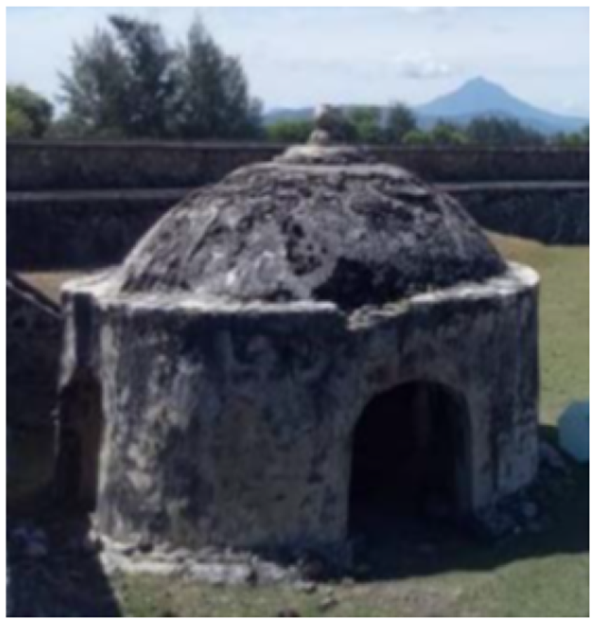
The fort bunker resembling a cylinder and a half sphere.
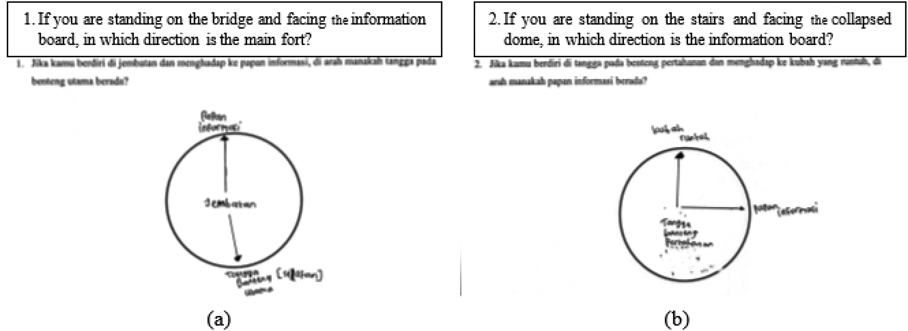
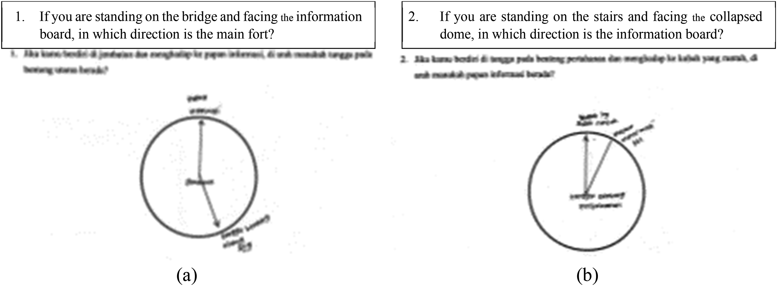
The subsequent activity involved determining the position of objects within the Indrapatra Fort. Students were tasked with independently sketching the object's position within the fort. SN posed a problem, including “If you stand on the bridge and face the information board, in which direction is the staircase on the main fort?” and “If you stand on the stairs on the defense fort and face the collapsed dome, in which direction is the information board?” SN then guided each student to draw the directional aspects of the objects on the student worksheet. Students’ solution for determining the position of Indrapatra Fort is presented in Figure 4.
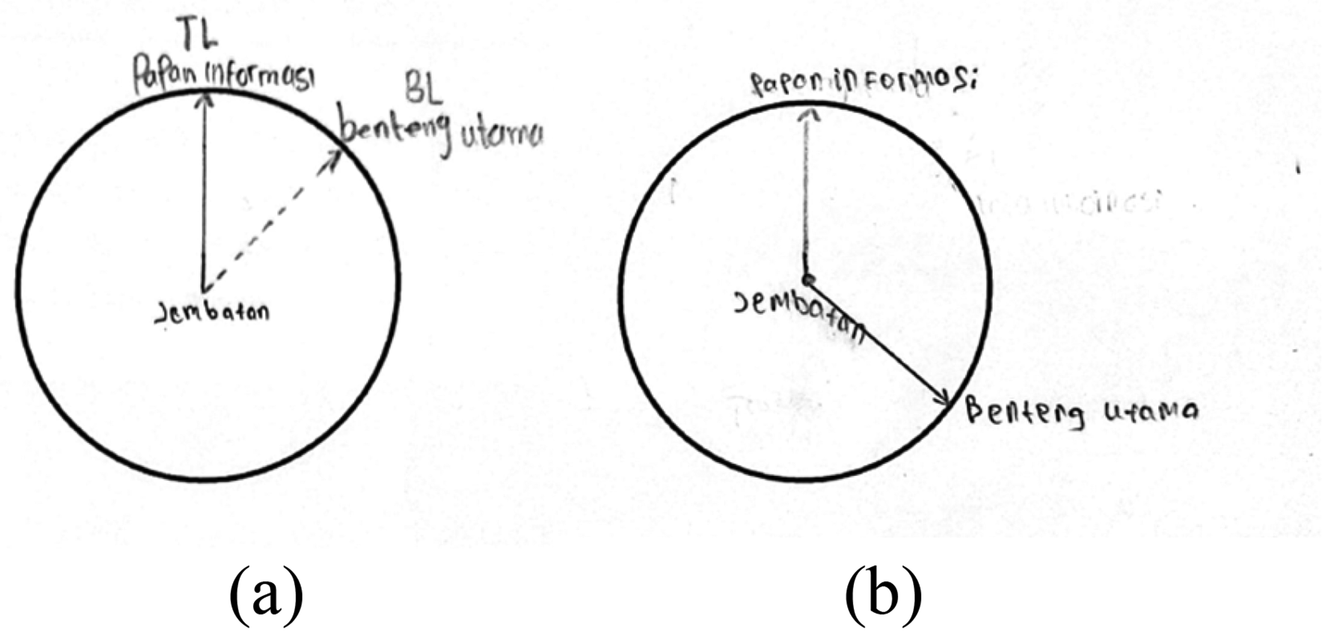
Students’ answers in determining the position of Indrapatra Fort.
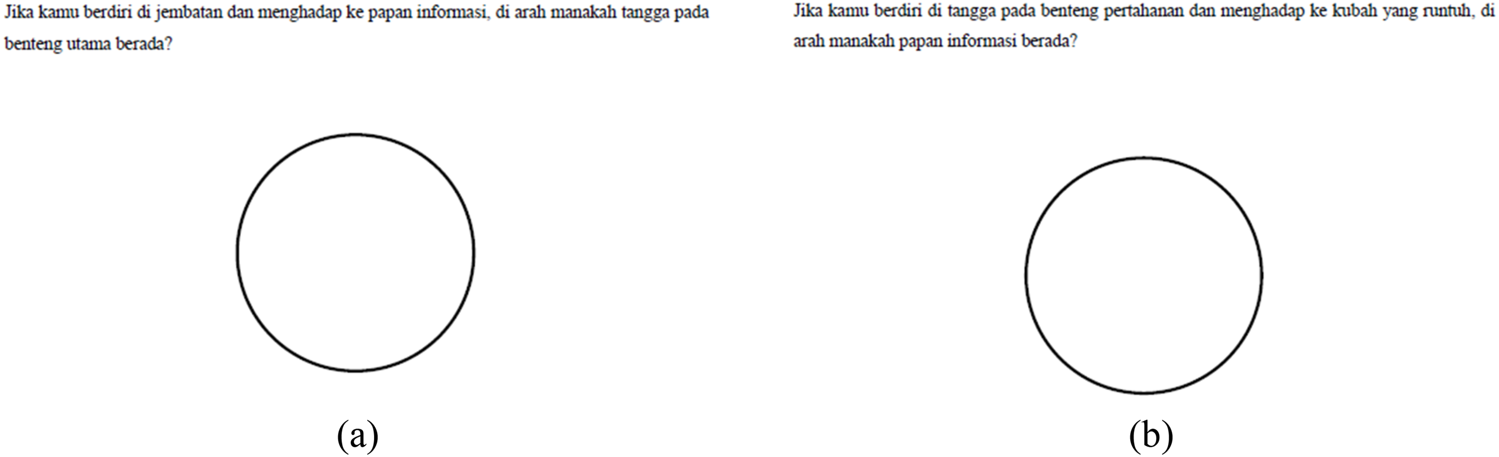
Figure 4 shows that students have not accurately identified the objects. In Figure 4(a), students were asked to determine the direction of the main fort when standing on the bridge and facing the information board. The students’ depiction of the bridge and information board was correct, but the position of the main fort was inaccurate. In Figure 4(b), students were tasked with determining the direction of the information board when standing on the stairs of the defense fort and facing the collapsed dome. The positions of the stairs of the defense fort and the collapsed dome were not illustrated. Students only noted the positions of the information board, bridge, and main fort, even though the positions of the bridge and main fort were not required in Figure 4(b). This issue arises because SN only verbally communicated the questions and did not write them on the student worksheet, preventing the students from accurately identifying objects in Indrapatra Fort. It is recommended to write the questions on the student worksheet for the problems shown in Figure 4(a) and (b), as illustrated in Figure 5.
Revised student worksheet, which is equipped with determining the position of objects in the Indrapatra Fort area.
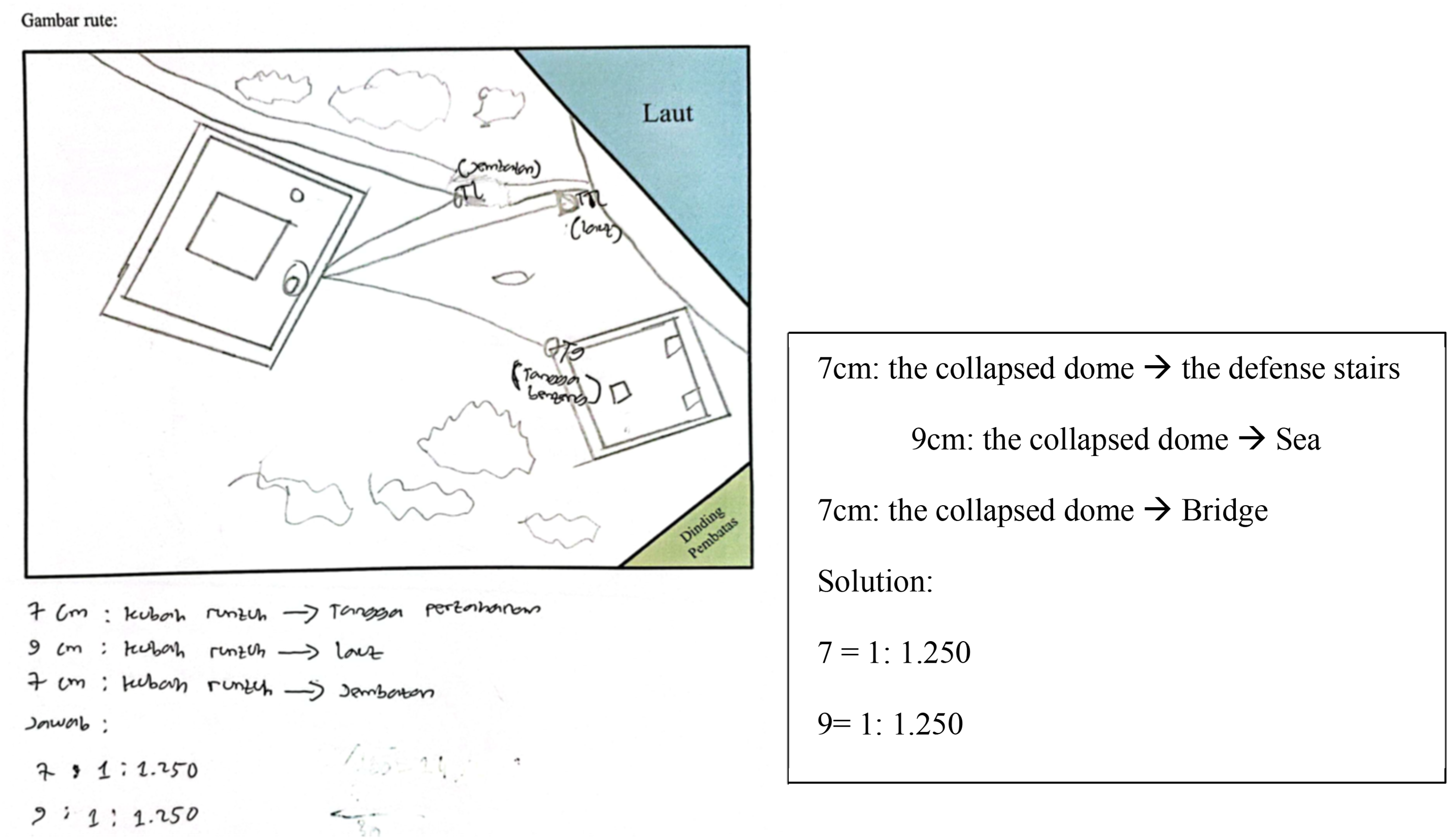
Next, students were asked to draw a visit route in the Indrapatra Fort area. One of the groups drew the following route (Figure 6).
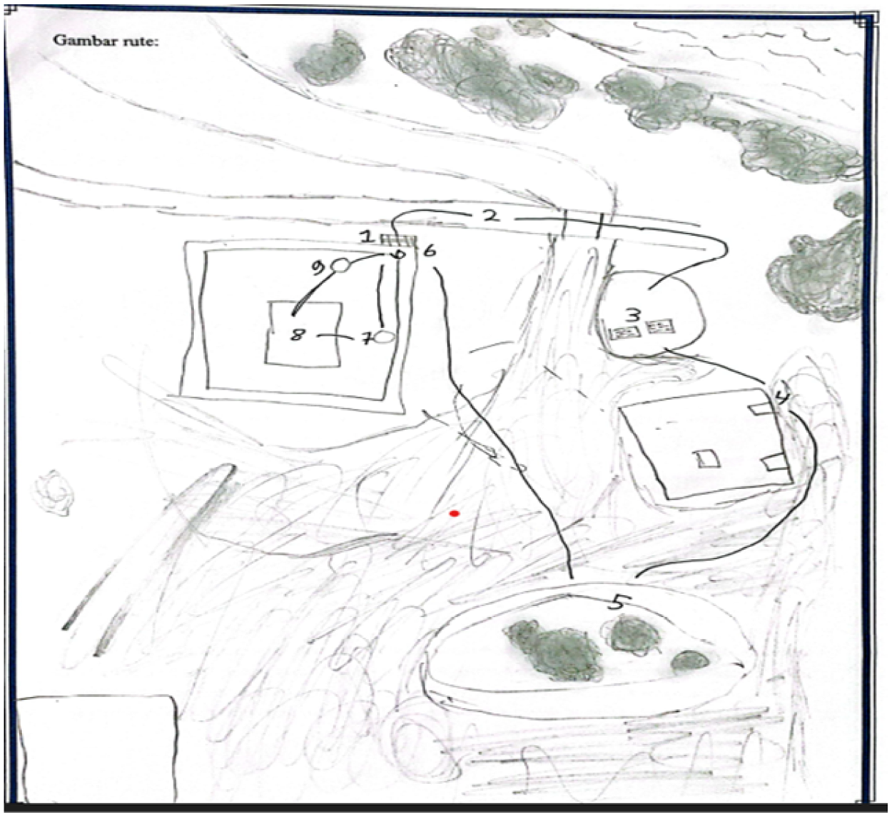
Student drawing of the visit route to the Indrapatra Fort area.
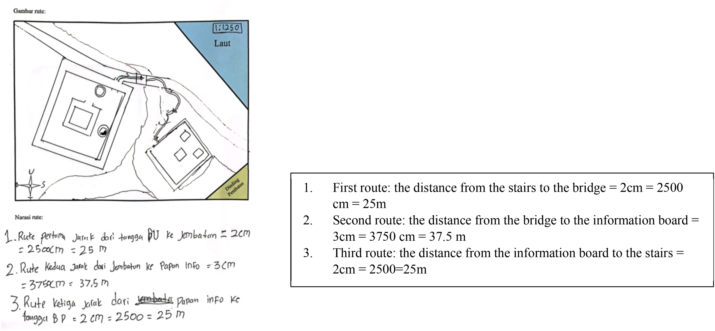
Figure 6 shows that students drew nine visit routes in the Indrapatra Fort area. Then, students wrote the narrative of the route, including the cardinal directions and the distance traveled based on the scale as in Figure 7.
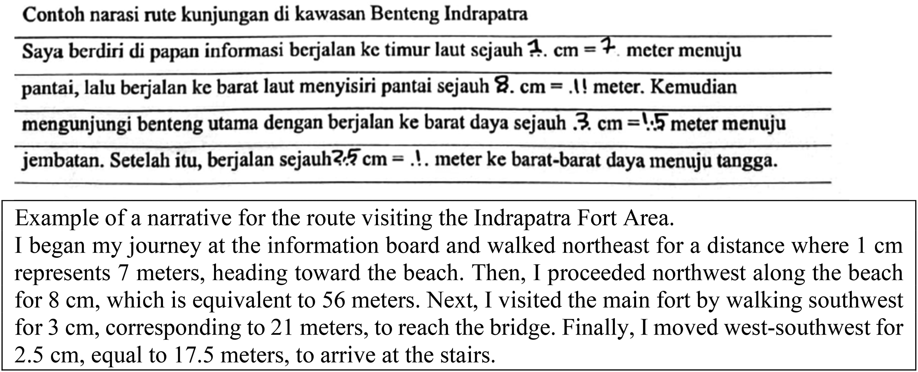
Narrative of the visit route in the Indrapatra Fort area.
Figure 7 illustrates that students did not compose narratives based on the drawings they created, as depicted in Figure 6. Instead, they merely employed the provided route narratives as shown in the student worksheet. Students marked the dots on the student worksheet regarding the distance on the plan and the actual distance. The interview revealed that students struggle to create a narrative, leading them to respond based on the provided examples of narration. Additionally, the time allocated by the teacher for narrative creation was limited. Moreover, students made errors in utilizing the scale to determine the actual distance. For instance, students noted that a distance of 1 cm on the map corresponds to 7 m in actual distance. In reality, 1 cm on the map should represent 1,250 cm or 12.5 m in actual distance, based on a scale of 1:1,250.
In class VIII-1b, AR initiated the learning by instructing students to design a miniature of Indrapatra Fort, as presented in Figure 3. The activity involved observing the illustration of Indrapatra Fort, as a half sphere, through GeoGebra (refer to Figure 8).
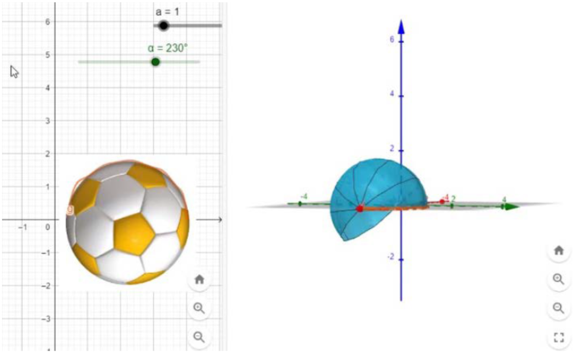
Illustration of a sphere and a half sphere.
Figure 8 illustrates an image of a sphere and a half sphere presented by the teacher through GeoGebra. Following the observation of the half-sphere miniature, students watched a video demonstrating three methods of creating the net of a sphere. Subsequently, students selected one of the models illustrating how to create the net of the sphere and replicate it using cardboard, aiming to construct the miniature dome of Indrapatra Fort. Figure 9 depicts three models of spherical nets showcased in the video.
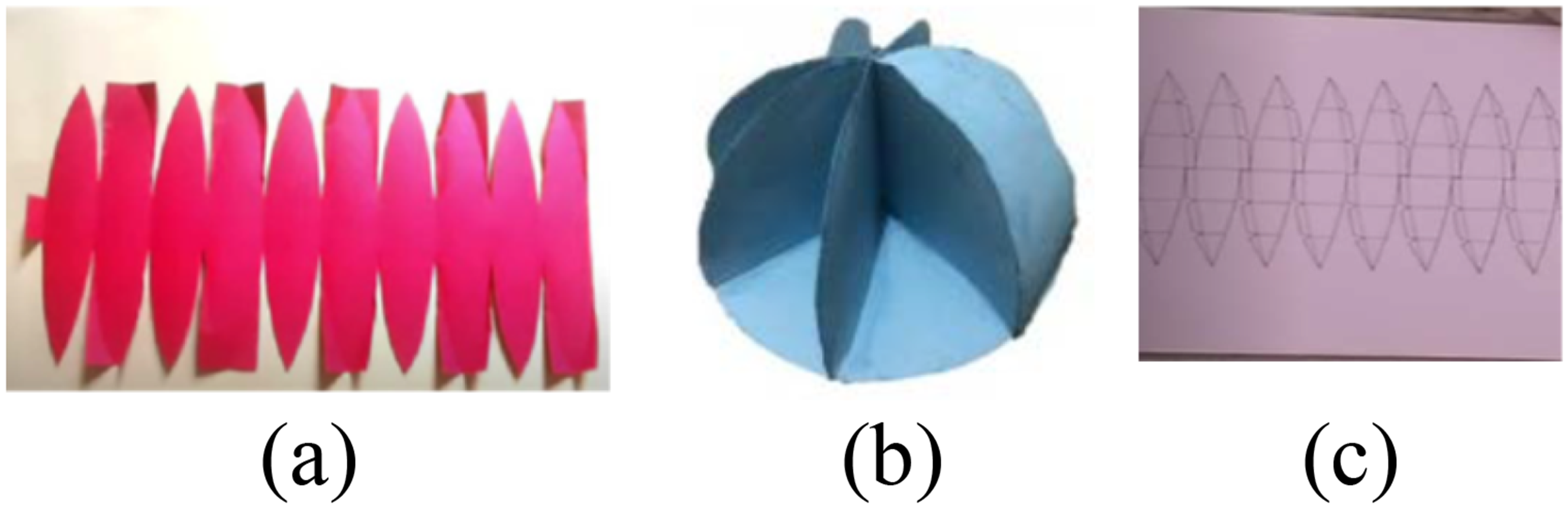
Three models of sphere nets shown in video.
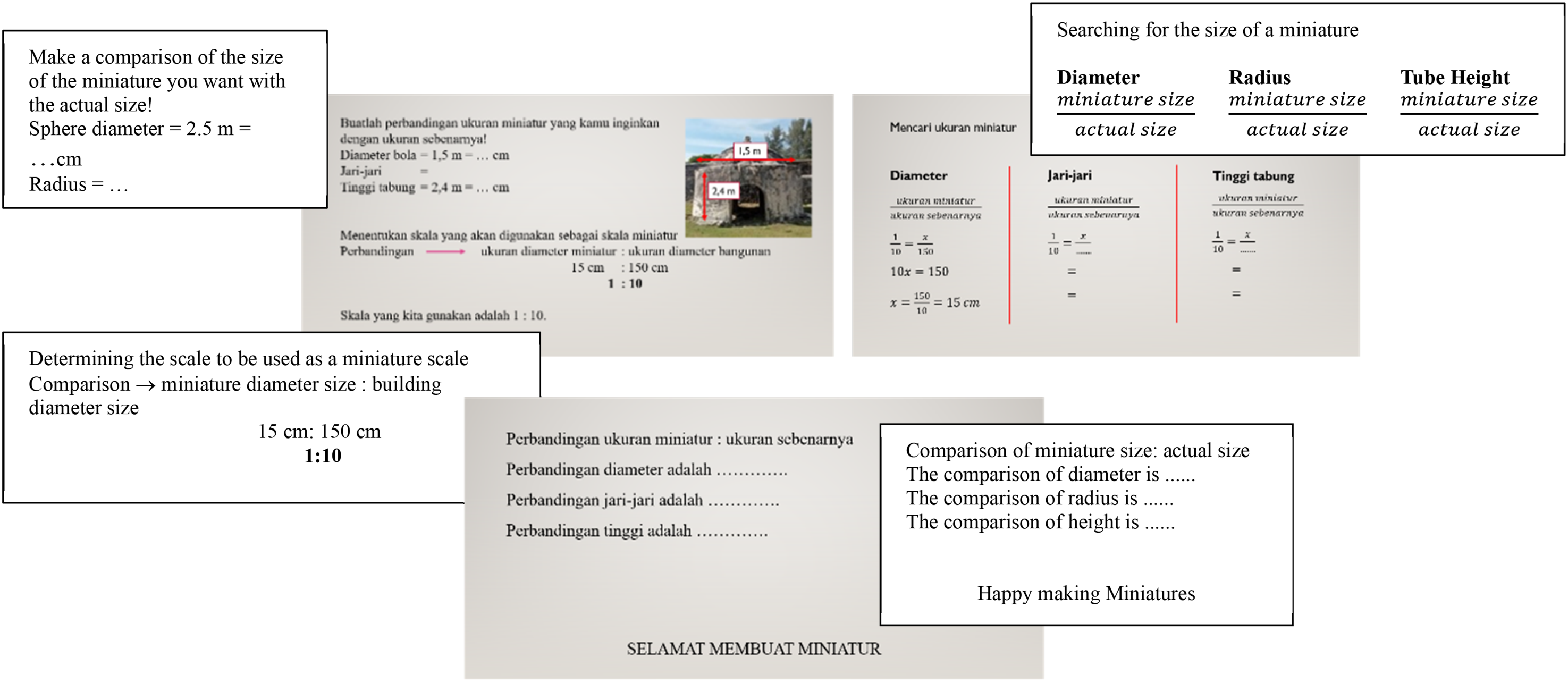
Based on Figure 9, one student group opted for the sphere net shown in Figure 9(a), while two others chose the sphere net displayed in Figure 9(b). The rationale for selecting the net in Figure 9(a) was its simplicity, material efficiency, and time-saving attributes. Conversely, the reason behind choosing the net in Figure 9(b) was its ease of design. Next, the teacher instructed the students to consider the diameter of the dome and the height of the Indrapatra Fort bunker. Students determined the number of pieces for the sphere net without adhering to a specific scale, as depicted in Figure 10.
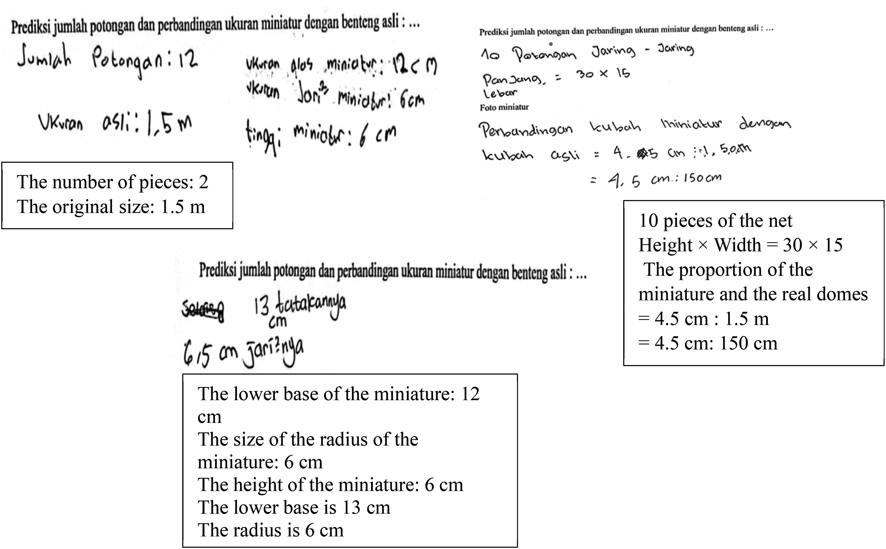
Students’ answers in choosing the nets.
In Figure 10(a), students anticipated that the net would consist of 12 pieces. Although the dome's diameter was accurately established at 1.5 meters, students erred in determining the size of the radius and height of the miniature. This miscalculation resulted from students neglecting to measure the miniature size through a comparison and scale approach. In Figure 10(b), students indicated that the ratio of the miniature dome to the real dome was 4.5 cm:150 cm. Students were expected to extend the comparison to accurately derive the miniature diameter, radius, and height. In Figure 10(c), students predicted 13 pieces for the net, with a calculated radius of 6.5 cm, lacking a specified method. Subsequently, students were tasked with constructing miniature domes and bunkers of Indrapatra Fort using cardboard. Throughout this activity, students drew the net of a hemisphere on the cardboard and attached each side to form a half sphere. Figure 11 illustrates the miniature dome shaped like a half sphere created by students.
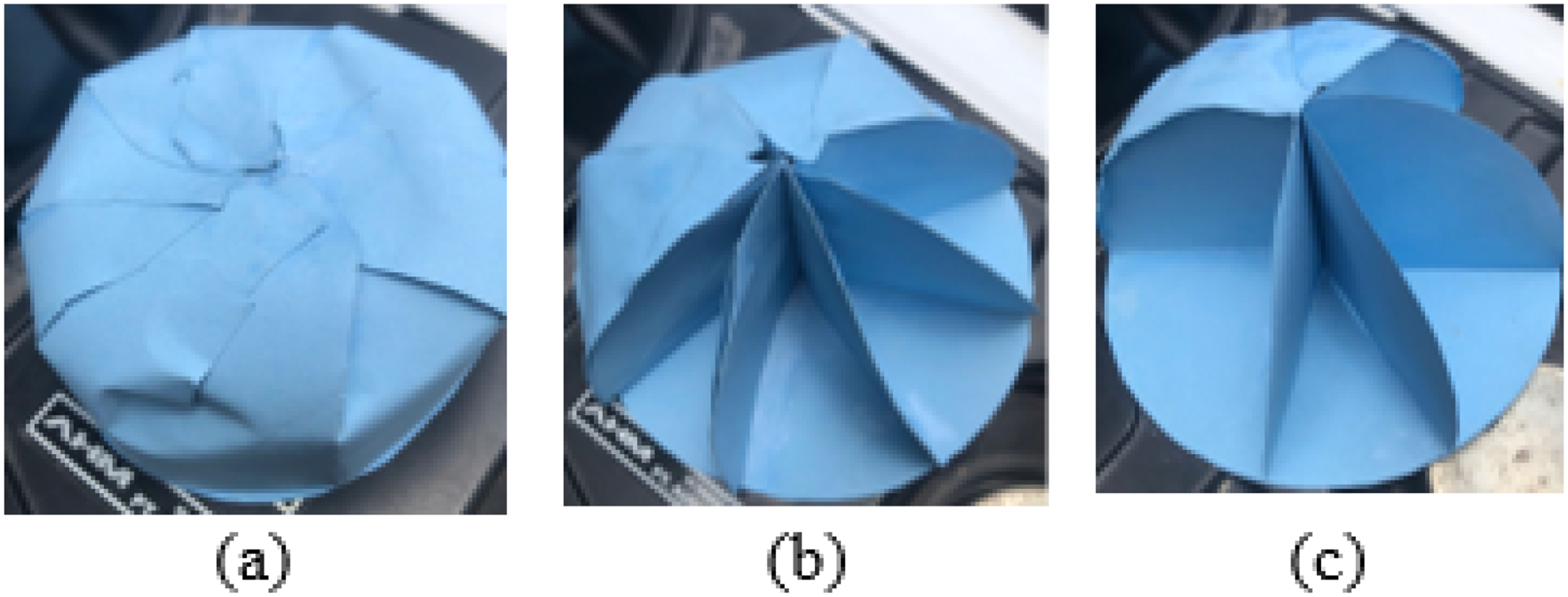
Student's miniature dome (a half sphere).
In Figure 11, three student groups successfully created a miniature Indrapatra Fort. Figure 11(a) displays a miniature dome utilizing the net from Figure 9(a). Unfortunately, students encountered challenges in attaching the net sides neatly and achieving the appropriate size due to inaccuracies in determining the size scale of the miniature fort compared to the actual fort. Subsequently, to ensure students’ comprehension, researchers conducted interviews with the students.
Why are the miniature domes not aligned? (See Figure 11(a))
We cut the paper incorrectly.
Did you calculate the correct size?
No. We miscalculated, so it is not aligned when pasting.
The size of the miniature nets should be calculated first so that they are neat and aligned when pasting.
Yes
From the interview, it is evident that students erred in calculating the size, resulting in non-parallel and unaligned sides of the miniature dome. Furthermore, Figure 11(b) and (c) depict miniature domes using the nets in Figure 9(b). Students failed to attach the entire half sphere net, preventing the formation of a complete miniature dome. To confirm students’ understanding, an interview was conducted with a student.
Why is the half-sphere net not fully pasted? (Refer to Figure 11(b) and (c))
We only saw it based on the video.
Is it better to close the half sphere to make it a complete miniature dome?
Yes. It should be.
Yes, exactly. You should not just stick part of it.
From the interview, it is evident that students did not cover each side of the miniature dome because they only watched a video on how to create the net of a sphere, which the teacher showed. However, the video provided by the teacher was only intended to illustrate how to make the net of the sphere, while the entire net of the sphere should be attached to form a miniature dome. Additionally, students only created miniatures resembling domes and did not make miniatures resembling the Indrapatra Fort bunker.
Based on the retrospective analysis of the HLT 1 trial, the following obstacles were encountered by students.
Students made mistakes in determining the cardinal directions. Students found it challenging to draw the position of Indrapatra Fort due to the lack of object descriptions on the Google Earth image of Indrapatra Fort. Students struggled to comprehend the questions posed by PTs in determining the position of Indrapatra Fort. Students made mistakes in determining the actual distance on the Indrapatra Fort area visit route. Students failed to write narratives based on the route drawings they created, instead relying on the route narratives given in the student worksheet. Students were unable to determine the scale size of the miniature fort and its actual size. Students did not fully paste the net made on the miniature dome of Indrapatra Fort. Students did not create the miniature bunker of Indrapatra Fort (the tube).
HLT 2: Preparing for the experiment
By considering the challenges encountered by students during the teaching experiment using HLT 1, the following revisions were made to the student worksheet.
In the activity of determining the position of objects in the Indrapatra Fort area, object descriptions were added to the Google Earth image of the Indrapatra Fort, such as descriptions of bridges, information boards, stairs of the defense fort, and collapsed domes.
Questions were also added to facilitate students in drawing the position of objects in the Indrapatra Fort area (see Figure 5). Before the activity of writing narration about the journey route in Indrapatra Fort area, a mini activity involving scale and comparison of distances on the map to actual distances was added.
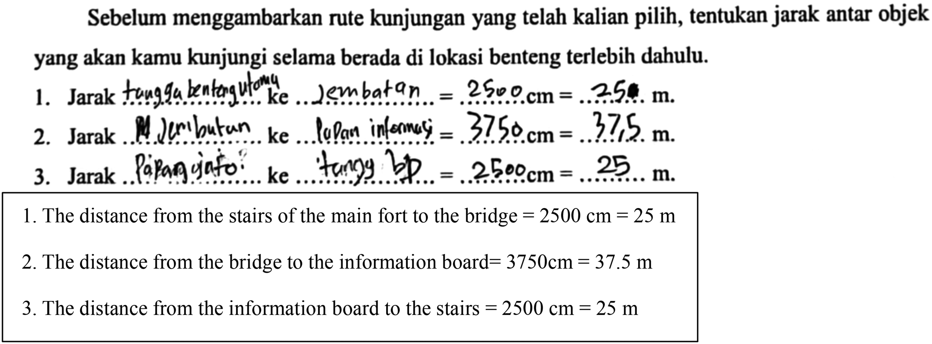
Before you sketch your journey route, determine the distances between the objects you will visit while at the Indrapatra Fort.
The distance from ……. to ……. = ……. cm = ……. m. The distance from ……. to ……. = ……. cm = ……. m. The distance from ……. to ……. = ……. cm = ……. m.
Thus, the changes in the student worksheet also impacted the revision of HLT 1, resulting in HLT 1 changing to HLT 2.
HLT 2: The teaching experiment and retrospective analysis
The teaching experiment of the HLT 2 trial was conducted by AR in class VIII-4, comprising 30 students. During the experiment, AR encountered several obstacles that were absent in the HLT 1 trial, as outlined below.
Students made mistakes in mentioning the cardinal directions. As presented in Figure 12(a), the students accurately determined the position of the objects. However, in Figure 12, students still erred in determining the object.
Students’ answers in determining the object of Indrapatra Fort.
Figure 12(a) illustrates that students successfully described the position of the main fort's bridge, information board, and stairs. In Figure 12(b), students were asked to determine the direction of the information board when standing on the stairs of the fortress and facing the collapsed dome. While the position of the fortress steps and the dome were correct, the location of the information board was inaccurate. Additionally, in Figure 12(a) and (b), students struggled to determine the cardinal directions. The mistakes differed from those in the HLT 1 trial, where students faced difficulty accurately determining the positions of objects in the Indrapatra Fort area (see Figure 4).
Students drew the route of visiting the Indrapatra Fort area discontinuously, as illustrated in Figure 13.
Student's drawing illustrating the route taken when visiting Indrapatra Fort area.
Figure 13 demonstrates that the routes visited by students included the collapsed dome to the defense stairs, the collapsed dome to the bridge, and the collapsed dome to the sea. The route was not continuous, resulting in the narrative produced by students lacking a coherent paragraph. The students should have structured their writing by describing the visit in a precise sequence: from the collapsed dome to the defense ladder, then from the defense ladder to the bridge, and finally from the bridge to the sea. The mistakes differed from those in the HLT 1 trial, as students successfully drew nine continuous visit routes in the Indrapatra Fort area (see Figure 6).
Students calculated the distance based on the unit ladder, rather than according to the scale, as shown in Figure 14.
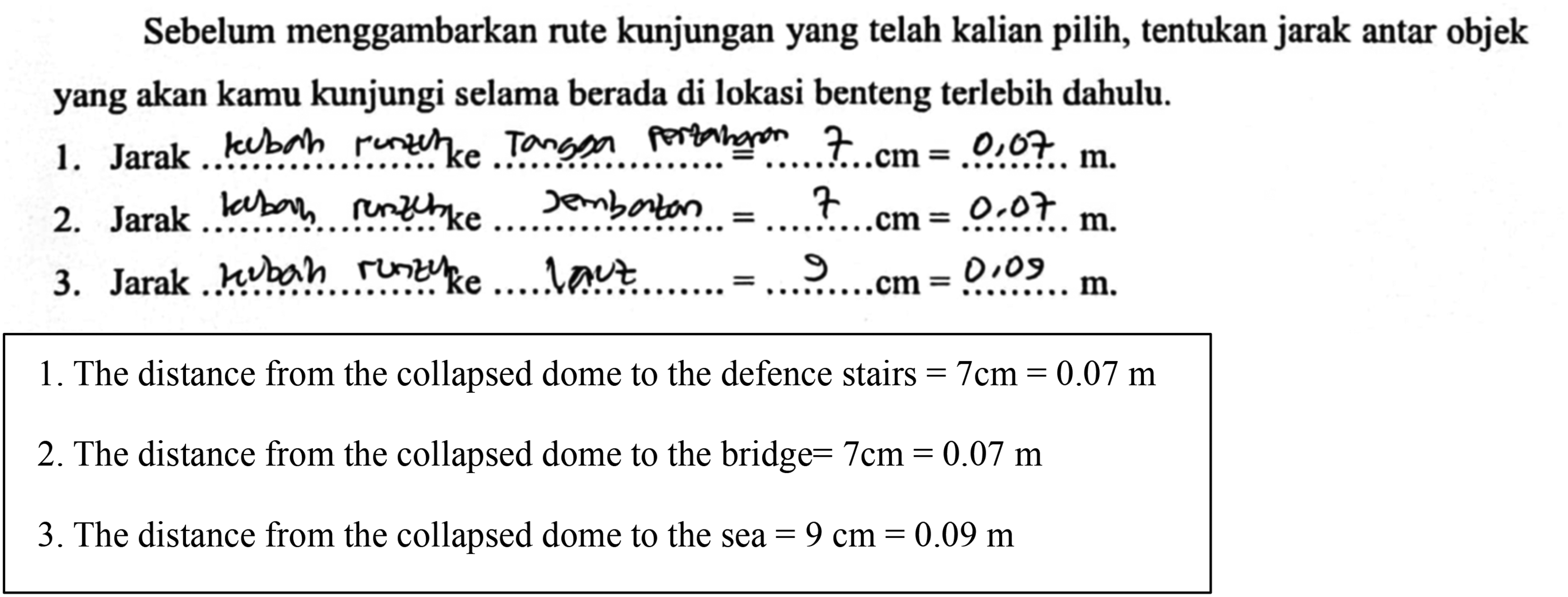
Students’ answers in determining the distance between the objects visited.
Figure 14 displays students’ responses in determining the distance between the visited objects. For instance, according to the students, a 7 cm distance on the map translates to 0.07 m in actual distance, which is accurate when considering the unit ladder. However, if calculated based on the scale, it is incorrect. The correct conversion for 7 cm on the map, according to the scale of 1:1.250, should be 8.750 cm or 87.5 m for the actual distance. In the HLT 1 trial, students also made mistakes in using the scale to determine the actual distance. For instance, students previously indicated that 1 cm on the map corresponded to 7 m in actual distance, whereas it should be 1,250 cm or 12.5 m, by a scale of 1:1.250 (see Figure 7).
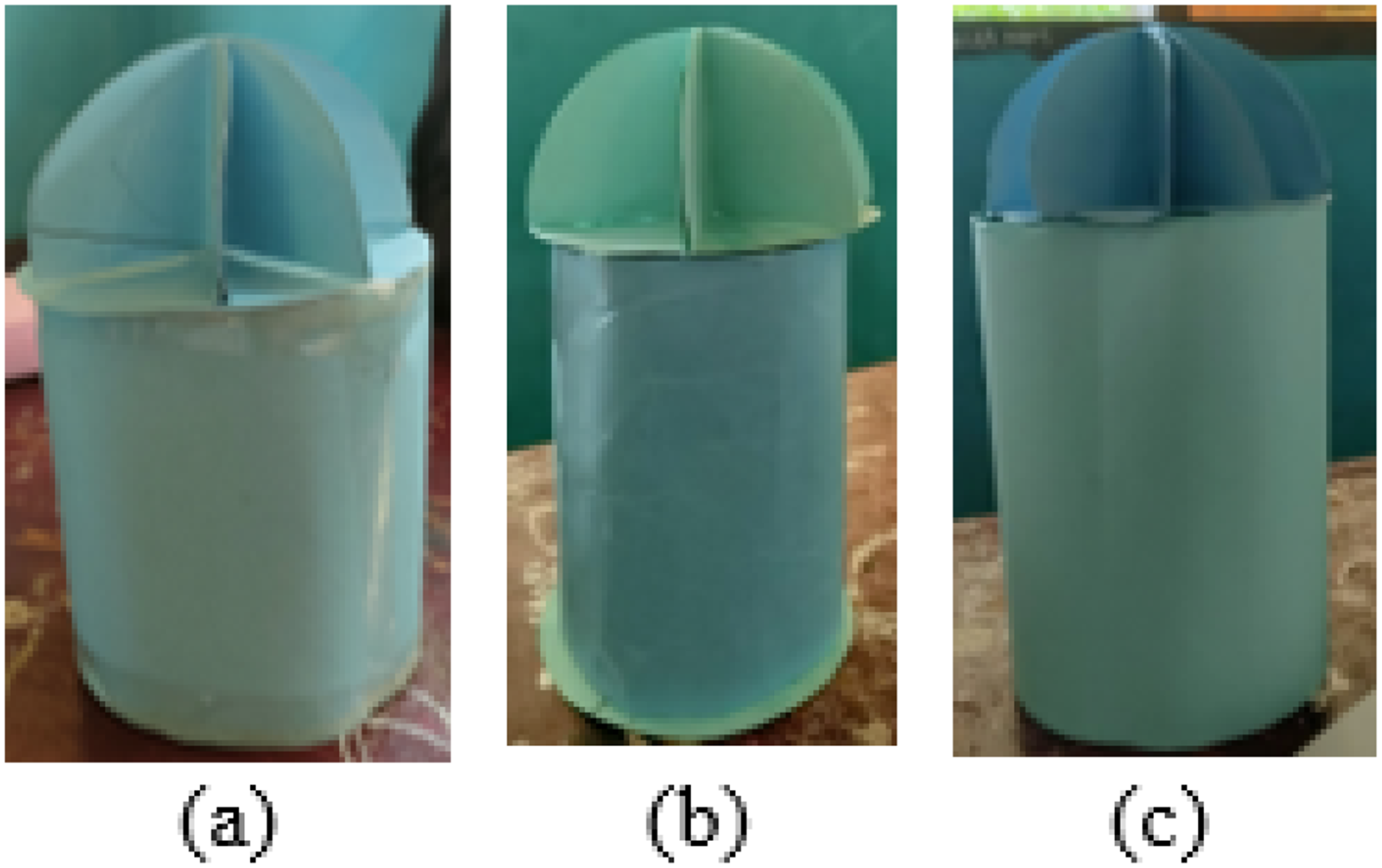
Students constructed miniature domes and bunkers of Indrapatra Fort, as illustrated in Figure 15.
Miniature of Indrapatra Fort.
While creating the miniature of Indrapatra Fort, only three groups of students completed the miniature entirely (Figure 15). However, there were variations in the size of the tubes made by the students. Furthermore, students failed to attach the entire net of the hemisphere, resulting in incomplete miniature domes. The subsequent interview was conducted to delve into the outcomes of creating miniatures, as depicted in Figure 15.
How did you calculate the surface area of the cylinder to cover all surfaces?
We determined the size by adjusting the surface area of the cylinder to fit the cover. If the cardboard is too long, we trim it to match the size of the cylinder's lid.
The surface area of the cylinder should be determined using the formula for the circumference of a circle, i.e.,
That's what we did
Yes, then why wasn't the net of the half sphere fully attached?
We only followed what was shown in the video.
Shouldn't you fully enclose the half sphere to create a miniature dome?
Yes. We should.
Yes. You should not only paste some of it.
The interview reveals that the student did not employ mathematical procedures to describe the surface area of the cylinder accurately. The surface area of the cylinder was merely adjusted to the size of the cylinder lid. If the cardboard for the surface area of the cylinder was too long, it was cut to match the size of the cylinder lid. In reality, the surface area of the cylinder should be equivalent to the circumference of the circle, allowing students to determine the size directly without cutting the excess cardboard. Additionally, students did not attach the entire net of the half sphere, resulting in incomplete miniature domes. This was due to students relying solely on videos the teacher provided demonstrating how to make sphere nets. However, the video only intended to illustrate how to create a sphere net, whereas the entire sphere net should be attached to form a complete miniature dome. In the HLT 1 trial, students exclusively crafted miniatures resembling domes and did not create miniatures resembling the bunkers of Indrapatra Fort (see Figure 11).
Based on the results of the retrospective analysis of teaching experiments using HLT 2, the alignment between students’ thought processes and the classroom events in HLT 2 teaching experiment can be outlined as follows.
The conjecture in identifying the spatial structure of Indrapatra Fort was accurate. Students could correctly identify that the bunkers and domes of Indrapatra Fort resemble a cylinder and a half sphere. The conjecture in determining the objects in the Indrapatra Fort area is inaccurate because students struggle to determine cardinal directions and express distances in meters based on the scale. The conjecture in drawing the route of visiting the Indrapatra Fort area is inaccurate because the routes drawn by students are discontinuous and not presented in a narrative form. The conjecture in observing the illustration of the sphere and half sphere through GeoGebra is accurate. The conjecture regarding the creation of a miniature dome of Indrapatra Fort is partially accurate. Students need to understand that each side must cover the entire net of the half sphere to form a complete miniature dome. Additionally, students need guidance on determining the surface area of a cylinder for the Indrapatra Fort miniature bunker.
In addition, the analysis of students’ responses to learning with HLT 2 indicated that in the third and fourth aspects, less than 80% of students provided positive responses (see Table 3).
Student responses to HLT
HLT 3: Preparing for the experiment
The HLT 2 trial revealed deviations in the activities from the conjectures (see Table 1). In this trial, the first meeting involved identifying the spatial structure of Indrapatra Fort, determining the position of objects within Indrapatra Fort, and drawing the visit route to Indrapatra Fort. The second meeting included students presenting the results of the visit route from the previous meeting, observing illustrations of spheres and half spheres on Geogebra, and watching videos on how to create a half sphere net. The third meeting involved determining the scale to create a miniature of Indrapatra Fort and drawing nets on cardboard. However, this activity was rushed and unstructured, causing some students to lose focus. In the fourth meeting, students did not bring the cardboard given at the previous meeting, leading to AR having to re-explain how to determine the scale and compare miniature and actual sizes. Consequently, these obstacles prompted the HLT 3 trial conducted with different PTs. The activities in HLT 3 were the same as those in HLT 2. The changes occurred in the conjecture about the students’ thinking process or strategy and the guided reinvention given by the teacher to the students.
HLT 3: Teaching experiment and retrospective analysis
In the HLT 3 trial, the activities conducted during the first meeting involved identifying the spatial layout of Indrapatra Fort and determining the position of objects within the fort. Subsequently, in the second meeting, students were tasked with drawing the visit route of Indrapatra Fort. The third meeting presented the results of the previous visit route, observed illustrations of spheres and half-spheres on GeoGebra, and viewed instructional videos on crafting half-sphere nets. During this meeting, students determined the scale for creating a miniature of Indrapatra Fort and drew nets on cardboard. SN's use of PowerPoint provided clear and comprehensible explanations (Figure 16).
PowerPoint used by PTs.
During these sessions, students attentively absorbed SN's explanations. Having learned from AR's prior experience, SN presented a clearer and more structured explanation of how to determine the scale. SN distributed cartons to each group, assigning students to continue the net drawing at home. The fourth meeting focused on constructing the miniature of Indrapatra Fort, with students completing the task.
The HLT 3 trial was executed by SN in classroom VIII-3, involving 30 students. Based on the trial, several obstacles emerged that were similar to the HLT 2 trial, as follows.
In the HLT 3 trial, students drew a continuous route visit in the Indrapatra Fort area (Figure 17).
Student-drawn visit route of Indrapatra Fort area.
Figure 17 illustrates that the routes followed by students were continuous, moving from the main fort stairs to the bridge, then from the bridge to the information board, and finally from the information board to the stairs of the defense fort. However, the narrative constructed by students did not form a cohesive paragraph, as they organized it based on points numbered 1, 2, and 3. These students’ answers about drawing routes were better than the HLT 2 trial, where students failed to draw continuous routes in narrative sentences (see Figure 13). Thus, throughout the learning process, the teacher taught students how to compose narratives yet again.
2. In the HLT 3 trial, students successfully created miniatures of the dome and bunker of Indrapatra Fort, as shown in Figure 18.
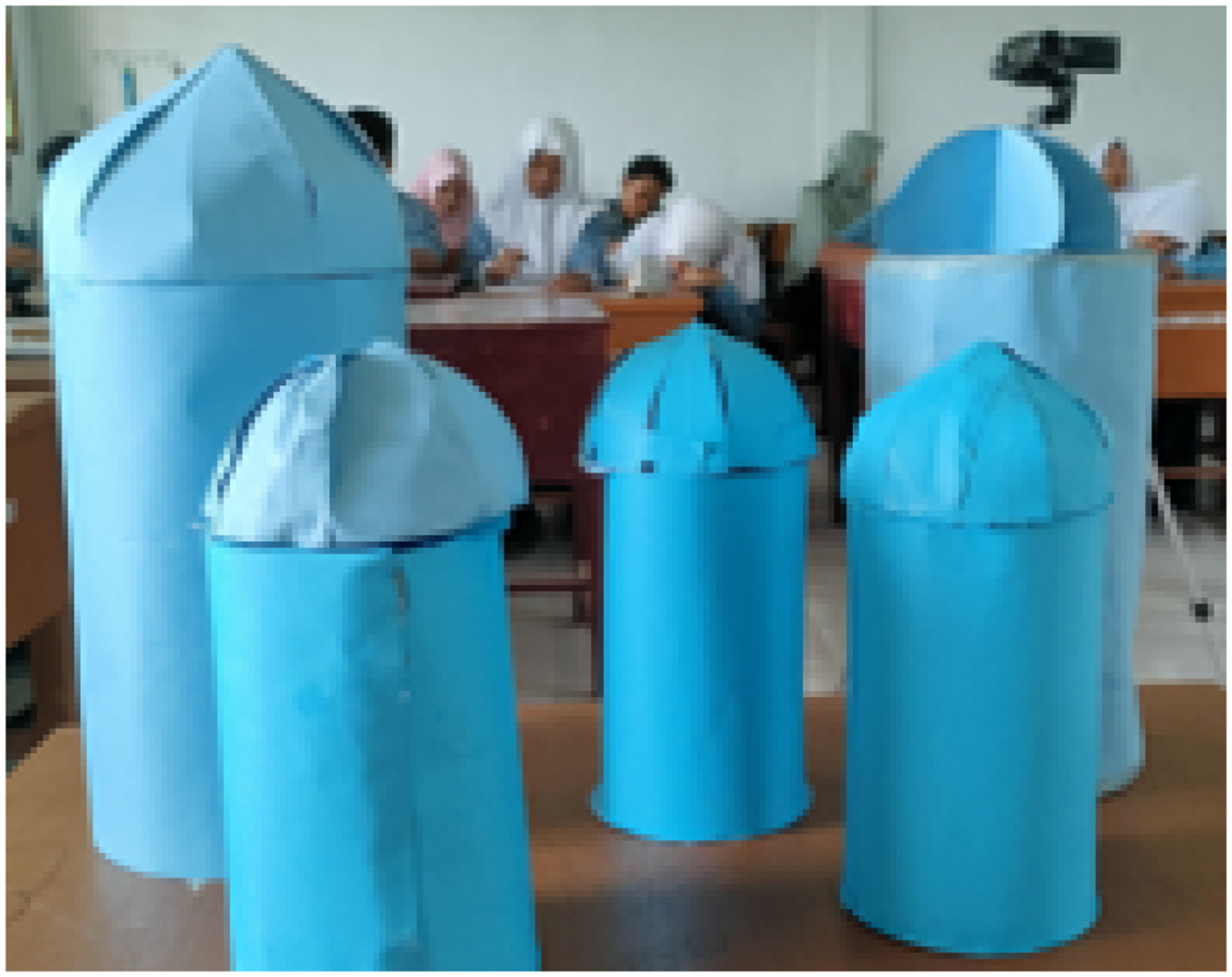
Miniature the half sphere dome.
Based on the miniature-making activity, five groups of students successfully completed the miniatures. Figure 18 demonstrates variations in the sizes of the cylinders crafted by different groups. However, one group failed to attach the entire hemisphere net, resulting in an incomplete miniature dome. An interview was conducted between researchers and students to gain insights into students’ understanding.
What is the size of the cylinder you made?
I don't remember
How did you calculate the surface area of the cylinder to cover all parts?
We estimated the size based on the dimensions of the cylinder's lid
The surface area of the cylinder should be determined using the formula for the circumference of a circle, namely
We can use the formula, can’t we?
Yes. Why wasn't the half sphere net fully pasted?
Because it's not finished
Is it better to ensure the half sphere is fully covered to become a miniature dome?
Yes
The interview revealed that students did not employ precise mathematical procedures in measuring the surface area of the cylinder, adjusting the size only approximately to the cylinder lid. The surface area of the cylinder should ideally be calculated using the formula for the circumference of a circle. Additionally, one group failed to complete the miniature dome due to unfinished work. This situation was similar to the HLT 2 trial, where students did not fully attach the half sphere net and the surface area of the cylinder was adjusted without utilizing the formula (see Figure 15).
Despite the obstacles faced in the HLT 3 trial, the following successes were achieved that had not been encountered in the HLT 2 trial.
1. In the HLT 3 trial, students successfully determined the position of objects in the Indrapatra Fort area, as illustrated in Figure 19.
Students’ answers in determining the object of Indrapatra Fort.
Figure 19(a) demonstrates that students accurately described the position of the bridge, information board, and stairs of the main fort. In Figure 19(b), students further demonstrated their ability to determine the position of the stairs of the defense fort, the collapsed dome, and the information board. Additionally, students successfully identified several cardinal directions based on the position of the information board and the stairs of the main fort. This was a notable improvement, as students’ answers were better than in the HLT 2 trial where they struggled with object positioning and cardinal directions (see Figure 12).
2. In the HLT 3 trial, students effectively determined distances based on the scale, as depicted in Figure 20.
Students’ answers in determining the distance between the objects visited.
Figure 20 displays students’ accurate determination of distances between the objects they visited. For instance, according to the students, the distance of 2 cm on the map was correctly interpreted as 2500 cm or 25 m for the actual distance, adhering to the scale of 1:1250. This finding contrasts with the HLT 2 trial, where students faced challenges using the scale to determine actual distances (see Figure 14).The connection between the students’ thinking process conjecture and the classroom events in HLT 3 is outlined as follows.
The conjecture in identifying the spatial structure of Indrapatra Fort proved to be appropriate. Students successfully recognized that the bunkers and domes of Indrapatra Fort resemble a cylinder and a half sphere. The conjecture on the activity of determining objects in the Indrapatra Fort area was validated, as students could determine cardinal directions and express distances in meters based on the scale. The conjecture on the activity of drawing the route of visiting the Indrapatra Fort area was partially appropriate, as students drew continuous routes. However, the students did not present the narratives in paragraphs. The conjecture in observing the illustration of a sphere and half-sphere through Geogebra was appropriate. The conjecture on making a miniature dome of Indrapatra Fort was validated. Students were successful, but the understanding that each side must cover the entire net of the half sphere for a complete miniature dome requires reinforcement.
Furthermore, to examine student reactions to the HLT, a questionnaire was administered to assess their responses to the ethnomathematics-based student worksheet, the learning environment, and SN's teaching methods. More than 80% of students responded positively to each aspect. Table 4 presents the students’ responses in detail.
Student responses to HLT
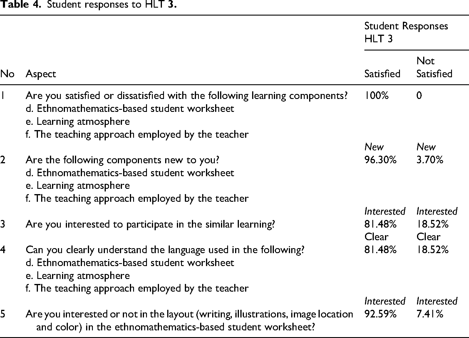
Based on the teaching experiment and retrospective analysis conducted during the third cycle, it can be concluded that the developed HLT 3 effectively supported students’ spatial abilities. The learning trajectories and conjectures aligned with the students’ activities throughout the teaching experiment. Moreover, more than 80% of the students provided positive responses across all aspects of the questionnaire. Thus, the development process concluded with HLT 3, which is now designated as the LIT.
5. Discussions
This research delves into students’ LT while developing an understanding of scale and proportion through a project on Indrapatra Fort. Gijbels (Holmes & Hwang, 2016) posited that project-based learning in mathematics involves collaborative and interactive activities, engaging in authentic problem-solving and real-life scenarios. Consequently, such learning supports students in constructing a deeper understanding of mathematical concepts, facilitating the retention of knowledge for application in comprehending new concepts and solving real-life contextual problems.
LIT are crucial in shaping students’ understanding and spatial ability. One effective approach is RME, requiring students to construct knowledge independently through activities within their learning process. The core concept of learning via RME approach is to provide students with opportunities to rediscover mathematical concepts by solving various real problems presented at the beginning of the learning process (Gravemeijer, 1994). RME approach comprises five key characteristics: context, implementation of mathematical models, interactivity, student contribution and construction, and intertwining. In Figure 2, RME approach is evident, where teachers design activities to progressively enhance students’ mathematical and spatial ability, commencing with real-world problems. Students engage in guided reinvention of mathematical concepts under the teacher's guidance (Treffers, 1991). These activities are structured in the form of HLT.
HLT comprises three components: learning objectives, learning activities, and learning process hypotheses that predict the development of students’ understanding (Gravemeijer & Cobb, 2006). In the initial research stage, the researchers designed HLT to understand scale and proportion in the context of Indrapatra Fort. The HLT utilized in the teaching experiment phase underwent refinement to be applicable in HLT 2 and HLT 3.
The findings indicate that the implementation of the HLT faced significant challenges. Nonetheless, students were able to solve some problems based on their conjectures. The activities included identifying the spatial structure of Indrapatra Fort, determining the position of objects in Indrapatra Fort, describing the route for visiting Indrapatra Fort, observing illustrations of spheres and hemispheres through Geogebra, and creating miniatures of Indrapatra Fort. These activities were structured across four levels: situations, models of, models for, and formal knowledge.
Based on HLT 1, three groups completed the student worksheet. At the situation level, students adeptly described the spatial structure of Indrapatra Fort, recognizing the bunker as cylinder-like and the dome as resembling a half sphere. However, when tasked with determining the position of Indrapatra Fort objects, students faced challenges, particularly in incorrectly identifying cardinal directions. This issue arises from students’ unfamiliarity with cardinal directions, emphasizing the significance of developing learning habits, as highlighted by Fletcher-Wood (2021). Learning habits influence student performance (Ebele & Olofu, 2017; Kaur & Pathania, 2015; Osa-Edoh & Alutu, 2012). Previous research by Wenno et al. (2021) also found that students did not understand the concept of cardinal directions in reading floor plans, as indicated by the indicator of mentioning cardinal directions (51% in the low category).
Moreover, students encountered difficulties drawing the position of Indrapatra Fort due to the absence of object descriptions on the Google Earth image. Some students rely solely on the Google Earth portrayal presented by PTs to familiarize themselves with Indrapatra Fort. In today's technologically advanced era, Google Earth serves as an effective learning medium, enhancing spatial thinking skills, cognitive knowledge, and problem-solving skills and broadening students’ insights into the benefits of information and technology (Demirci et al., 2013; Deutscher, 2011; Hsu et al., 2018; Johnson et al., 2011; Thankachan & Franklin, 2013). It contributes to improved spatial literacy, encompassing the ability to determine location, distance, and spatial relationships (Hamdanah et al., 2020). While Google Earth is user-friendly, offering accessibility with just a computer and an internet connection (Green et al., 2007; Patterson, 2007), its effectiveness is evidenced by Xiang and Liu's (2017) research, showcasing its significant impact on students’ spatial thinking skills.
However, Hilman (2012) noted Google Earth's limitations cause difficulty in viewing maps. This is attributed to satellite data and other sources producing unclear images, especially in areas with economic value considerations. Image quality varies between urban and rural settings, influenced by outdated data sources and the lack of real-time updates. Image clarity also depends on internet bandwidth, memory capacity, monitor screen quality and computer processor capabilities. Notably, Google Earth lacks a feature for adding image captions.
To address these challenges, researchers revised the student worksheet by incorporating object descriptions into the Google Earth image of Indrapatra Fort. These descriptions include details about bridges, information boards, fortress stairs, and collapsed domes, aiming to enhance students’ clarity when viewing the Indrapatra Fort image on the student worksheet. Despite these efforts, students’ motivation to restore Indrapatra Fort remains limited, as they primarily rely on Google Earth visits. The researchers suggest that direct visits would likely increase student motivation for Indrapatra Fort restoration efforts.
At the situation level, students also encountered difficulties comprehending questions posed by PTs to determine Indrapatra Fort's position. Tambychik and Meerah's (2010) research supports this, indicating that students face challenges understanding and responding to mathematical problems due to insufficient visual–spatial ability, mathematical abilities, and cognitive capacities. In response, the researchers incorporated additional questions into the student worksheet to help students draw the positions of objects in the Indrapatra Fort area.
At the model of level, students encountered challenges in determining the distance on the Indrapatra Fort visit route, primarily due to miscalculations based on the established scale and misinterpreting cardinal directions. Their calculations often deviated from the predetermined scale. Furthermore, creating a coherent narrative based on the chosen visit route was challenging for students, who struggled with word retrieval, grammar, and developing ideas in written form (Torrance & Galbraith, 2006). A study by Alpriyani et al. (2019) identified several issues in students’ narrative writing, including ineffective sentence construction, struggles with idea development, and discrepancies in adhering to Indonesian spelling conventions.
Transitioning to the model for level, students engaged in activities involving the observation of illustrations of spheres and half spheres through Geogebra and creating miniature domes of Indrapatra Fort. However, challenges arose in calculating the scale for the miniature size of Indrapatra Fort. This finding aligns with Arista et al.'s (2022) research, highlighting students’ challenges in solving math problems related to scale and proportion, which lead to errors.
At the formal knowledge level, students failed to attach the entire net to the miniature dome of Indrapatra Fort. Their reliance on instructional videos provided by PTs for making sphere nets contributed to this omission. Moreover, time constraints prevented students from completing the cylinder-shaped miniature of the Indrapatra Fort bunker. Learning duration emerged as a significant factor impacting student outcomes (Entwistle & McCune, 2004; Parpala et al., 2010).
The HLT developed underwent revision due to unproven conjectures identified in HLT 1, such as students’ challenges in determining cardinal directions, miscalculations of actual distances, issues in determining the scale when drawing the route, and weaknesses in writing narratives related to the visit route. An incomplete net attachment on the miniature dome of Indrapatra Fort was observed, likely due to reliance on instructional videos. HLT 1 highlighted students’ difficulties in learning spatial orientation, specifically in determining cardinal directions and drawing routes, a consequence of the novelty of spatial learning, requiring more time for comprehension (Akayuure et al., 2016; Hirza et al., 2014).
In HLT 2, PTs’ rushed and unstructured explanations hindered students’ understanding, emphasizing the need for improved activity design during HLT 3. Although challenges persisted in HLT 3, including incomplete narrative formation, five student groups completed the student worksheet, indicating an improvement in quality. A well-designed LIT can positively influence students’ understanding and cognitive flow (Anwar et al., 2012; Winarti et al., 2012).
In short, students’ understanding of scale and proportion progressed from the informal to the formal stage through the development of a miniature of Indrapatra Fort. This finding aligns with Hans Freudenthal's RME approach, emphasizing the connection between mathematics and reality. Teachers can consider this HLT a valuable reference for designing project-based spatial learning that incorporates scale and proportion concepts.
The results of the student response questionnaire in the HLT 2 trial revealed that students did not respond positively to the clarity of the learning components and their interest in participating in the subsequent learning processes. This lack of positive response is due to students’ dissatisfaction with the ethnomathematics-based learning approach, leading to boredom. The teacher introduced three activities during the first meeting: spatial orientation exercises, drawing routes, and determining the distance on the route based on the map scale. The overwhelming density of the content resulted in student fatigue, as prolonged exposure to demanding tasks can induce negative moods (Ahola et al., 2005; Bakker et al., 2000). Thabrany (1994) emphasized that fatigue, a common symptom of which is boredom or mental fatigue, negatively affects learning concentration. Students experiencing saturation find concentrating challenging, as learning readiness is compromised when boredom sets in (Slivar, 2001).
HLT 3 has effectively enhanced students’ spatial abilities, as the designed conjecture aligns well with the activities conducted during the teaching experiment. Additionally, students responded positively to all measured aspects. This success can be attributed to the gradual arrangement of activities based on the students’ cognitive levels, combined with the teacher's effective implementation of these activities. Experienced teachers are better equipped and prepared for teaching than their less experienced counterparts (Downing & Dyment, 2013; Scherer et al., 2021). Figure 2 Adapting subject matter to the students’ environment ensures the content remains relevant and engaging (Darimi, 2015). Given the teachers’ crucial role in the teaching and learning process, their experience has significant impact on the overall quality of education (Sanjaya, 2009).
However, some students provided answers that were slightly different from what was expected in HLT 3. Instead of writing a narrative, the students describe their journey route within Indrapatra Fort in points. One way to overcome this constraint is to take several strategic steps, such as preplanning, making notes, rough drafting, and so forth (Torrance & Galbraith, 2006). Therefore, the researchers inserted a mini activity to train students in writing a narrative. In this mini activity, students are asked to construct a narrative about their journey without considering about the distance. By completing this mini activity, the number of processes that need to be managed simultaneously is reduced. Li et al. (2022) suggest that encouraging students to break down problems into smaller components can help them better understand the relationships between quantities, aiding in the construction of coherent narratives.
To summarize, the distinction between HLT 3 and HLT 1 lies in the model of level activity. The assignment in HLT 1 was to write a narrative about the journey route, including the distance. Whereas, HLT 3 included a mini activity to write the narrative without considering the distance and the conversion from the distance on the plan to the actual distance using scale. The HLT 3 with this mini activity is termed LIT.
6. Conclusions
Based on the study results, it is concluded that developing LITs through RME based on ethnomathematics and technology, supports students’ spatial ability. The LIT outlined in this study delineates the students’ learning route, progressing through various levels or stages of mathematics modeling. The LIT begins at the level of situation, where students identify the spatial objects of Indrapatra Fort, resembling a cylinder and a half sphere, and determine distances and cardinal directions related to the fort's objects. Advancing to the model-of level, students drew a visit route in the Indrapatra Fort area. Moving to the model-for level, students observed illustrations of spheres and half spheres through GeoGebra, determining the scale of the miniature dome of Indrapatra Fort. Finally, at the formal knowledge level, students conclude the steps to create a miniature of Indrapatra Fort, which is a cylinder and a half sphere.
Students responded positively to each aspect evaluated, displaying great enthusiasm for learning within the context of Indrapatra Fort. Their interest was notably piqued by the content and activities presented in the student worksheet. Furthermore, students expressed eagerness towards participating in future learning processes, demonstrating a strong interest in the learning they have experienced.
In this study, it is apparent that students required additional practice creating narratives related to the visiting route, particularly those involving cardinal directions and scale. A few students failed to fully articulate the procedure for creating miniatures. Hence, it is recommended that future research explore collaborative learning initiatives between mathematics and Indonesian language teachers. Such an approach would help students in developing narratives that align closely with spatial ability.
Footnotes
Acknowledgements
We would like to thank Universitas Syiah Kuala and Ministry of Education and Culture of Indonesia. The authors also acknowledge the Department of Education and Culture of Banda Aceh City for their support and facilitation. We sincerely thank the validators, teachers, and students for their valuable contributions to this study.
Informed Consent
All participants were informed about the study's purpose, procedures, risks, and their rights. Written informed consent was obtained before participation, in accordance with ethical guidelines.
Contributorship
All authors designed the research. RJ and CK developed the learning materials and collected the data. AF initiated proposal and methodology. SG and CS reviewed the learning trajectory. LA initiated technology. All authors contributed equally in writing and reviewing the manuscript.
Funding
We would like to thank Universitas Syiah Kuala and Ministry of Education and Culture of Indonesia for Riset Kolaborasi Indonesia (Grant Number: 556/UN11.2.1/PT.01.03/PNBP/2023).
Declaration of Conflicting Interests
The authors declared no potential conflicts of interest with respect to the research, authorship, and/or publication of this article.
Author Biographies
![]() .
.