
Abstract
This paper examines a climate buffer infrastructural paradox: that, despite an expansive archive documenting the limits of hard structural solutions, they retain their allure as a popular technical solution to protect against climatic hazards. The Leyte Tide Embankment Project (LTEP) in the Philippines, also known as “The Great Wall of Leyte”, is one of dozens of climate buffer megaprojects proliferating globally that promise to protect coastal zones from increasingly devastating climate hazards. Using the LTEP as a case study, we ask: what and who drives and sustains hard infrastructure as climate adaptation, and through what processes? To analyse this question, we conducted 45 in-depth interviews with project proponents, government officials, academics, practitioners and community members, as well as reviewed relevant documents to unravel the relations of power and politics that position the project as an effective and popular adaptation strategy. Through the lenses of urban political ecology and infrastructure studies, we argue that the LTEP derives its allure from the infrastructural politics of (in)visibility: the strategic deployment of hard infrastructures as visual tools to advance political agendas. These politics selectively highlight elements that symbolise protection and progress while obscuring aspects that fail to meet technical and aesthetic standards. The infrastructural politics of (in)visibility are shaped by multi-scalar power dynamics linking global and local interests that are propelled by a constellation of actors with diverse agendas and become active sites of negotiation and contestation where communities can organise and voice dissent.
Keywords
Introduction
Climate change adaptation often relies on technocratic and physical infrastructural solutions such as seawalls and dykes, despite a widespread acknowledgement of their frequent maladaptive outcomes (Eriksen et al., 2021; Ojha et al., 2016). Nightingale et al. (2020) call this a “technical trap” and argue that this technical focus obscures an understanding of climate change as produced by political economic systems and uneven power relations and knowledge regimes (Boyd, 2017; O’Brien and Selboe, 2015). One of the most common technical fixes to coastal inundation is climate buffer infrastructure, which establishes a land-sea boundary while aiming to protect communities, essential infrastructure and livelihoods from the adverse impacts of coastal hazards. Climate buffer and other hard infrastructures are emerging at pace, in physical interventions ranging from polders in the Netherlands (Warner and Wiegel, 2021), to dams in Pakistan (Philip, 2020), and seawalls in the Pacific (Klöck et al., 2022).
While hard infrastructures may be effective in protecting people and property behind the shoreline, they are based on socio-spatial and temporal trade-offs. As Cooper and McKenna (2008) summarise, coastal infrastructures externalise future environmental and economic costs. Yarina and Takemoto (2017) note that seawalls tend to amplify erosion on the other parts of coastline, while dykes exacerbate flooding for those outside of the walls. Hard infrastructures are often costly to maintain, poorly adaptable to long-term climate impacts, and frequently unsuccessful in vulnerable areas like small islands, where many similar structures remain unfinished or damaged (Donner and Webber, 2014; Nunn and Kumar, 2018). Consequently, some experts instead support the use of “soft” approaches such as wetland restoration or beach nourishment (Gesing, 2017). For instance, the parallel concept of nature-based solutions (NBS) has been endorsed in the Intergovernmental Panel on Climate Change (IPCC, 2019) and the Global Commission on Adaptation (2019) as an approach that can tackle both adaptation and mitigation challenges and deliver co-benefits for people and nature.
This paper examines a climate buffer infrastructural paradox: that, despite an expansive archive documenting the limits of hard structural solutions, they retain their allure as a popular technical solution to protect against coastal hazards. We draw upon research in urban political ecology (UPE) (Lawhon et al., 2014) and infrastructure studies (Larkin, 2013; Lawhon et al., 2018; McFarlane and Rutherford, 2008), that has sought to re-politicise climate adaptation as a contested process infused with questions of justice and inequality (Mikulewicz, 2018). In doing so, we attend to the infrastructural realities of the Global South, following postcolonial provocations to broaden the empirical and theoretical scope and ‘provincialise’ urban theory (Chakrabarty, 2007; Roy, 2009) and disaster studies (Gaillard, 2023). By examining hard infrastructure from the perspective of the South, we create the “possibility for a broader range of urban experiences to inform theory on how urban environments are shaped, politicised, and contested” (Lawhon et al., 2014: 498).
However, although recent research to ‘situate’ urban political ecology (Lawhon et al., 2014) has demonstrated the prevalence of heterogeneous infrastructure configurations in the Global South, the proliferation of climate buffer infrastructure suggests further attention is needed to understand its ongoing allure and power. Challenging the modern ideal of a universal and standardised networked infrastructure (Graham and Marvin, 2001), heterogenous infrastructure configurations show how communities engage in practices like manipulating electrical metres, rainwater harvesting, and tinkering with water networks (Lawhon et al., 2018; Wright-Contreras et al., 2017). While this research demonstrates the importance of informal and hybrid infrastructural arrangements, less attention has been paid to how formal infrastructure projects continue to dominate development agendas despite their documented limitations. An “infrastructure frenzy” (Schwanen and Denver, 2019: 147) is unfolding across cities, where hard infrastructure is promoted as a way to build climate resilience (Anguelovski et al., 2016; Chu et al., 2017). Attending to this return of hard infrastructural solutions situated in the Global South will further expand our understanding of the power and meanings of infrastructure.
We focus on coastal Tacloban City in the Philippines, listed as the country most at risk to extreme weather events by the World Risk Report (Bündnis Entwicklung Hilft/ IFHV, 2024). Hard infrastructures have been central to the country's development agenda, pursued through “public-private partnerships that first took shape in the 1990s, expanded in the 2000s, and intensified in the Build-Build-Build program in the 2010s” (Saguin and Alvarez, 2022: 147). These large-scale infrastructure projects, including expressways, railways, and flood control systems—aim to modernise urban space and manage environmental risks. As Philippine cities grapple with compounding climatic hazards, hard infrastructures have been propelled to the top of the government's priorities. The national government has earmarked PHP 780 billion (USD 13 billion), approximately 12% of its proposed annual national budget for 2025 for flood control projects (Beltran, 2024). Yet these projects are frequently criticised for reinforcing social and spatial inequalities, legitimising displacement, and privileging elite urban interests (Ortega, 2020; Saguin and Alvarez, 2022). Despite these criticisms, the infrastructural ‘frenzy’ persists, framed by the national government and urban elites as a necessary and benevolent act to save the vulnerable (Alvarez, 2019).
To understand the allure of hard infrastructural solutions, we ask: what and who drives and sustains hard infrastructure as climate adaptation, and through what processes? To answer these questions, we organise our paper as follows. In the next section, we situate our research at the intersection of UPE and infrastructure studies, understanding infrastructure as thick with power, politics, visions, and imaginaries (Harvey and Knox, 2012). In the third section, we present our study site and discuss our case study. The fourth section details our research methods, while the fifth section presents our empirical findings. We illustrate the symbolic and representational roles of the infrastructure, elements made visible and invisible, and actors normalising and expanding hard coastal protection. We find proponents render certain elements visible to portray the project as effective and inclusive, but these performative accounts are fragile and contested. The final section reflects on what we refer to as infrastructural politics of visibility—the strategic use of hard infrastructures as a visual tool to enact and advance political agendas—and argues for conceptualising infrastructures as contested sites embodying technical, symbolic, and aesthetic functions.
Understanding infrastructure through urban political ecology and infrastructure studies
Like other forms of climate adaptation, hard infrastructure projects are more than technical interventions (Mikulewicz, 2018). Dominant approaches to flood protection emphasise large-scale infrastructural interventions like seawalls and embankments, embodying a technocratic view of controlling nature (Arnall, 2023; Yarina and Takemoto, 2017). However, critical scholars argue that such technical solutions often generate, rather than address, vulnerabilities (Eriksen et al., 2021). For instance, in Fiji, seawalls built to protect communities from sea level rise have threatened marine ecosystems and shifted vulnerabilities to people and places elsewhere (Piggott-McKellar et al., 2020). Additionally, because technocratic adaptation projects often overlook local power structures, they often end up benefiting elites over marginalised groups (Henrique and Tschakert, 2019). Despite the growing attention to its limits, techno-optimism persists, with hard infrastructure retaining its allure for protection, economic development, and service provision (Lawhon et al., 2023).
We combine urban political ecology (UPE) and infrastructure studies to highlight the politics of (in)visibility that sustains the enduring allure of hard infrastructures as adaptation. UPE is a theoretical framework that politicises resource access and control in urban spaces. It foregrounds the uneven power relations and patterns of winners and losers embedded in the (re)production of urban environments (Swyngedouw, 2005; Swyngedouw and Heynen, 2003). In relation to urban adaptation, UPE has been used as a framework to examine the potential for adaptation to perpetuate exclusion, encroachment, enclosure, or entrenchment (Sovacool and Linnér, 2016) and to explore the uneven distribution of flood hazards and responses to floods, including their potential to entrench inequalities and dispossession of the poor (Colven, 2017; Henrique and Tschakert, 2019), including in informal settlements (Desai, 2012).
While UPE has been instrumental in politicising the production of urban environments, its concepts often reflect Northern epistemologies, limiting their resonance with the diverse socio-spatial realities of Southern cities (Lawhon et al., 2014; Robinson, 2006). In response, we engage with Southern urbanism and postcolonial theory to treat Global South cities as sites of theorisation in their own right. This entails foregrounding local histories, epistemologies and material conditions (Chakrabarty, 2007; Roy and Ong, 2011), and, in our case, interrogating how infrastructures reflect and reproduce uneven power relations. We build on efforts to connect UPE with the infrastructural turn in social science (Amin, 2014; Anand et al., 2018), moving beyond descriptions of infrastructural inequities to understand the processes of normalisation in producing and managing infrastructure as a climate solution (Graham and McFarlane, 2015).
The “modern infrastructure ideal” of universal and uniform networked services (Graham and Marvin, 2001) has limited application in the Global South where infrastructural disruption is the norm (Kooy and Bakker, 2008). Critical urban scholars have shown that infrastructures in the Global South are often incremental (Silver, 2014), hybrid (Lawhon et al., 2018) and post-networked (Monstadt and Schramm, 2017), combining centrally-planned systems with informal and self-organised components. Our concern, however, is not only with how infrastructures are assembled or accessed, but also with the institutional logics and socio-political imaginaries that contribute to the allure of hard infrastructure as a preferred mode of adaptation, despite the condition of infrastructural heterogeneity. This requires understanding infrastructure not only as materially heterogeneous, but as socially and politically constructed.
We draw insights from geography, socio-technical studies, and anthropology to broaden our infrastructural imagination and see infrastructure as a lived and multi-dimensional phenomenon (Steele and Legacy, 2017). As Star (1999) emphasises, infrastructures are not fixed systems but dynamic assemblages that are reconfigured through processes of negotiation and mutual adjustment with adjacent systems and practices. Furthermore, Dourish and Bell (2007: 415) describe an “infrastructure of experience,” wherein infrastructures become meaningful through their embeddedness with the cultural organisation of everyday life, shaping and being shaped by how people navigate space, access services, and imagine urban futures. Conceived relationally, infrastructure is not merely a response to environmental threats but a socio-political process that reinforces structural inequities while also producing new subjectivities and imaginaries. This processual view sharpens our focus on how infrastructural projects retain their enduring allure as climate adaptation.
A relational understanding of infrastructure foregrounds what Colven (2020) calls the politics of (in)visibility: the ways infrastructures are made to appear or disappear in public consciousness and everyday life. Infrastructures are not mere backdrops that fade into view during breakdowns (Thomas, 2021). Rather, they are materially present and symbolically loaded: visible when development promises and political spectacle are needed (Schwenkel, 2015) and invisible when overlooking and neglecting certain people's rights (Colven, 2020). For instance, Wade (2019) highlights how Jakarta's Great Garuda project visibly embodies state-led ambition while rendering invisible the millions of informal residents whose livelihoods are excluded from the new waterfront city. Such projects demonstrate that (in)visibility is not an inherent property but a political process with significant social and environmental stakes.
To deepen our understanding of the politics of (in)visibility in infrastructure, we follow Larkin (2013) in identifying key functionalities of infrastructure: technical, semiotic, and aesthetic. First, infrastructures are deeply connected to technical and scientific knowledge that underpins their performance of a set of functions. Larkin (2018, p. 175) argues that infrastructures can be seen as material assemblages “caught up in political formations whose power in society derives from their technical functions”. The technical component of infrastructures includes the specific technologies, materials, and networks necessary for their operation. For instance, Anand (2011)[8] discusses the water provision system in Mumbai, emphasising its reliance on a complex network of pumps, pipes, engineers, and state officials to function effectively. Infrastructure also includes scientific knowledge, advancements and expertise that enable their construction and operation.
Second, infrastructures go beyond their stated technical functions to shape social relations and subjectivities. Larkin (2013: 329) describes these as semiotic functions that “emerge out of and store within them forms of desire and fantasy… that sometimes can be wholly autonomous from their technical functions”. Infrastructures can be perceived as semiotic objects that shape and constitute subjects by influencing cultural norms and social behaviours. For instance, in Vinh City, Vietnam, piped water infrastructures are not simply technical systems that provide water. Schwenkel (2015) showcased how, through the engagement with new technological systems, a water supply project promised progress and signalled the city's integration into the community of “advanced” socialist nations. German engineers were symbolic of international expertise and international connectedness, installing iron pipes and ceramic toilets. Through the project, the residents “were able to see and hear material betterment through the spectacle of German engineering” (Ibid., pp 527). Moreover, infrastructures are not mirrors of existing social relations but reconfigure them (Petersson, 2021). Infrastructure offers a window into how we perceive and respond to challenges such as poverty, public health, or environmental risks. These interpretations are shaped by actors such as governments, engineers, and international donors, who embed their values, ideologies, and priorities into infrastructural forms.
Third, infrastructures are imbued with aesthetic dimensions. Larkin (2020: 188) notes that “infrastructural phenomena—switches, pipes, cables, roads, sewers, bridges, railways, servers—operate on the level of form as well as technics”. In studies of urban Asia, scholars highlighted the importance of sensory registers such as sight, smell, and affect in governing urban space (Baviskar, 2003; Roy and Ong, 2011). Ghertner (2015a) terms this phenomenon “aesthetic governmentality”, arguing that public spaces are reconfigured based on adherence to aesthetic standards: land uses conforming to dominant aesthetic codes are preserved, while those that do not are marginalised. What is deemed aesthetically pleasing often reflects a narrow, elite vision of a “modern city”—characterised by cleanliness and the absence of slums and informality (Baviskar, 2003). For example, Colven (2020) illustrates how hotels and shopping centres in Jakarta were permitted in water catchment areas since they meet aesthetic codes, whereas residents of informal settlements faced eviction for not conforming to these unstated criteria.
In summary, our understanding of the infrastructural politics of (in)visibility makes three claims. First, infrastructures are heterogeneous in form and function. They are made up of diverse materials, technologies, institutional logics and socio-political imaginaries. Second, infrastructures are not static or self-contained objects but relational and processual. Their functioning and meanings emerge through ongoing interactions and are shaped by socio-political dynamics. Third, infrastructures are entangled with the politics of visibility and invisibility. Their presence and significance may be selectively revealed or obscured depending on whose perspectives are centred. In conceiving infrastructures in the Global South in this way, we now set out to investigate the social and material work that their operations—technical, aesthetic, semiotic—perform.
The Leyte Tide Embankment Project
Recent years have seen a revival of high modernist development logics in the Global South, where large-scale infrastructure projects are once again framed as unambiguous symbols of development and progress (Dye, 2016). In the Philippines, these imperatives have taken shape through an aggressive state-led drive to modernise and expand infrastructure networks across the archipelago. In response to chronic infrastructural deficits such as inadequate public utilities, ageing transport systems and limited connectivity between urban and rural areas (Llanto, 2016), the Duterte administration launched the “Build-Build-Build” (BBB) program. Aiming to increase infrastructure spending from 5.4% of GDP in 2017 to 7.3% of GDP in 2022 (Patalinghug, 2024), this ambitious program funded infrastructure projects like roads, bridges, airports, seaports, railways, and urban transit systems, among others. While BBB fared well in terms of project spending, analysts have noted that the program failed to harmonise infrastructure investments across regions and missed its targets due to technological constraints, right-of-way issues, low implementing capacity, and COVID-19 impacts (Ibid). Despite these shortcomings, current President Ferdinand Marcos Jr. has continued the infrastructure push through at least 194 Priority Infrastructure Projects under the “Build Better More” program, which has drawn criticism for its disproportionate focus on more developed regions like the National Capital Region and Central Luzon, over poorer and smaller areas in Visayas and Mindanao (Famatigan, 2023).
This study focuses on Tacloban City, the administrative and economic capital of the Eastern Visayas Region in the province of Leyte (Figure 1). Despite being classified as a first-class highly urbanised city (HUC)—a designation based on annual income of PHP 50 million (2.5 million USD)—with over 251,000 inhabitants across 138 barangays, Tacloban is ranked behind most other HUCs in the country in the government's social and economic indicators. In 2023, the government's Cities and Municipalities Competitive Index (CMCI, 2025) ranked Tacloban 18th out of 33 HUCs nationwide, based on indicators like economic dynamism, government efficiency, infrastructure, resiliency, and innovation, indicative of the city's struggles with poverty and marginalisation. This was further exacerbated when the city was devastated by Super Typhoon Haiyan in November 2013. One of the strongest typhoons ever recorded, Haiyan brought winds exceeding 300 kilometres per hour and storm surges up to 4 metres high (Fitzpatrick and Compton, 2017). According to a report by the National Disaster Risk Reduction and Management Council (2013), among the 6300 fatalities across the country, 5877 were from the Eastern Visayas region. Tacloban sustained extensive infrastructure damage, in part due to its geographical location: a low-lying port city at the apex of a funnel-shaped coastline where the southern coast of Samar island meets the eastern coast of Leyte island (Su and Le Dé, 2020). Tacloban's coastlines, which include some of its poorest communities, bore the brunt of Haiyan's powerful waves and storm surges (Iuchi and Maly, 2016).
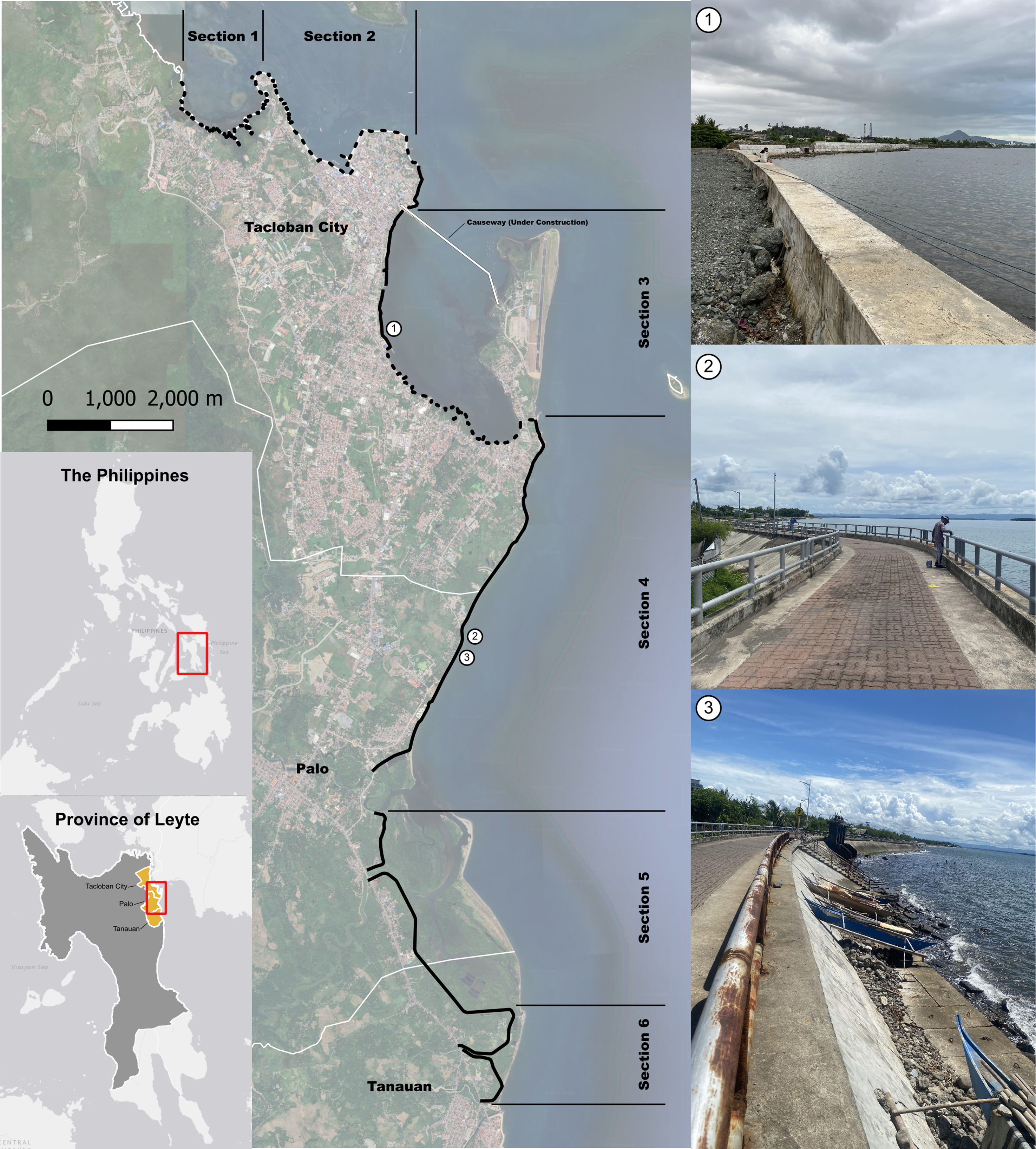
Map of Leyte Tide Embankment Project location and characteristics. Source: authors (2024).
In the aftermath of Typhoon Haiyan, the government established a no-build zone policy, leading to the eviction of informal settlers located within 40 metres of the coastline (Fitzpatrick and Compton, 2017). The local government partnered with various NGOs to develop its post-Haiyan reconstruction plan called Tacloban Recovery and Rehabilitation Plan (TRRP), focusing on ecological modernisation and balancing development with environmental protection. The TRRP proposed relocating around 14,000 families from the no-build zone to Tacloban North, 10 km from the coast (Yee, 2019). Protective infrastructure plays a central role in Tacloban's TRRP, envisioning the city as a “bay island that diminishes the push of the water into the bay during typhoons” (Tacloban City Government, 2014: 63). The Local Climate Change Action Plan 2017–2025 allocates PHP 7.9 billion (USD 140 million) for coastal protection, while the Comprehensive Development Plan 2023–2028 outlines key flood control strategies, including “constructing slope and coastal protection systems along riverbanks and coastlines” (Tacloban City Government, 2023: 201). Yee (2018: 111) confirms the prominence of “infrastructural and geoengineering interventions that aim to reduce the risks of external hazards” in the city.
This emphasis on hard infrastructure is exemplified in the national government's Leyte Tide Embankment Project (LTEP). Dubbed the “Great Wall of Leyte”, the LTEP was launched as a direct response to the catastrophic damage caused by Haiyan and aims to protect communities from the impacts of future storm surges. The project involves raising existing roads and the construction of a tide embankment spanning the coastlines of three municipalities: Tacloban, Palo, and Tanauan (Yee, 2018). The LTEP will construct “28.48 kilometres of flood mitigation structure and 16 kilometres of backwater dike structure” (Meniano, 2022). It is comprised of six sections: Sections 1 to 3 are in Tacloban, Section 4 and 5 are in Palo, while Section 6 is in Tanauan (Figure 1). The project was started in 2016 and is currently 62% completed (Meniano, 2024a).
Japan International Cooperation Agency (JICA) played a key role in the technical planning and design of the LTEP, with five Japanese engineering firms designing the embankment. 1 The Department of Public Works and Highways (DPWH) served as the Philippine implementing partner, conducting geotechnical investigations and topographical surveys. According to project proponents, the estimated PHP 16.95 billion (USD 300 million) cost is funded through the national government's General Appropriations Act (GAA), with no loan components. JICA also assert that “environmental and social protection measures were carefully considered”, with public consultations held in the affected provinces (Japan international Cooperation Agency, 2017: 18). An Environmental Compliance Certificate (ECC) was issued by the Department of Environment and Natural Resources (DENR) to ensure compliance with environmental regulations (Unite, 2017).
Research methods
This paper employs a qualitative case study methodology (Yin, 2018) to investigate the infrastructural politics of the Leyte Tide Embankment Project (LTEP) in Tacloban City. Fieldwork was conducted in two phases: an initial scoping phase from September to December 2023 and a data collection phase from January to June 2024. To explore the project in depth, we utilised a mixed methods approach to data collection and analysis. More specifically, we conducted semi-structured interviews with 45 respondents, including provincial and local government officials from the Mayor's Office, City Housing, City Engineering, City Environment and City Disaster Risk Office (n = 15), researchers and academics (n = 5), NGO staff (n = 5), and community members living near the seawall (n = 20).
Interviews were carefully designed to explore participants’ lived experiences, perspectives, and insights into the LTEP. Interviewees were selected through purposive sampling, based on their expertise, roles, and direct experiences with the project. Themes discussed in the interviews included the objectives of the project, which actors were involved, the decision-making processes associated with the project, the nature of collaboration between JICA and the Philippine government, and the expected socio-economic and environmental impacts of the project. All interviews were conducted in Waray-Waray (the language spoken in Eastern Visayas), audio recorded with respondents’ consent, and subsequently transcribed and translated to English; respondents are anonymous in this paper.
We used NVivo qualitative data analysis software to systematically code and analyse the interview transcripts. The thematic analysis followed a structured approach: first, we conducted open coding to identify initial themes, then we subsequently developed focused codes that aligned with our research questions pertaining to the technical, aesthetic, and semiotic components of the LTEP. We also catalogued direct quotes that were representative of emerging themes and used verbatim excerpts to provide contextual insights into our interviewees’ perspectives. In addition to interview data, we also reviewed relevant engineering reports about the LTEP, the project reports from JICA, and various media and newspaper reports. We draw on this data to highlight the politics of visibility and invisibility that frame the project as a permanent solution to storm surges and a model of urban development and economic growth, despite public concerns over maladaptation to increasing climate threats.
The tide embankment's technical, semiotic, and aesthetic functions
In this section, we analyse the contested politics of visibility and invisibility in the LTEP across its technical, semiotic, and aesthetic functions. This analysis draws upon Larkin’s (2013) conceptual framework for the functions of infrastructure which resonates strongly with patterns that emerged from our fieldwork. This tripartite framing enables us to systematically unpack how infrastructures operate as technical solutions, semiotic representations, and aesthetic interventions in urban space. We show that the project performs beyond its technical role of protecting communities against storm surges, carrying with it symbolic and developmentalist visions that serve particular political elites, government, and project proponents. Through strategic efforts that highlight protection and obscure socio-ecological risks and displacement, we demonstrate how LTEP advances a speculative urban development agenda that prioritises tourism and commercial development over the livelihoods and social relations of communities.
Technical functions of the LTEP
The technical functions of the LTEP are as a physical barrier between rising seas and volatile storm surges and the city of Tacloban. In the technical documents, project proponents highlight the durability of the LTEP in its design. The embankment has a trapezoidal cross-section where the base is wider than its top, ensuring the embankment's ability to absorb wave energy. JICA assures that “the tide embankment… will not collapse even if the storm surge water overtops its crest” (Japan International Cooperation Agency, 2017; Chapter 4, pp. 22). Base concrete blocks were also added to “prevent scour on the toe of the tide embankment” (Ibid., Chapter 2, pp. 46). JICA designed the height of the embankment to vary between 2.8 and 4.5 metres, high enough to counteract storm surges. It also includes wave dissipating concrete blocks to reduce wave energy as they approach the structure (Ibid., see Figure 2.2–44). In addition, 42 drainage outlets were installed to effectively drain flood waters (Ibid., Table 4.4-2). Built into the embankment are flood gates and extra-large culverts to facilitate the controlled release of floodwaters back into the sea.
Based on this design, JICA and DPWH insist on the protective capabilities of the embankment. Despite varied opposition from local civil society groups and residents that the project is ineffective, exclusionary to informal settlers, and harmful to marine life, JICA actively lobbied for and defended the project's construction. Citing its benefits in protecting communities, a JICA representative asserted that “this project is for their [residents] own good” (Sunstar Philippines, 2015). JICA provided numerical estimates to make the case of protection more compelling, claiming that “for a 50 year return period storm surge, 30,800 houses/buildings will be protected and an area of 27.3 km2 will be protected” (Japan International Cooperation Agency, 2017; Chapter 2, pp. 12). One of the project contractors, local construction company Premium Megastructures Inc. (2018), posted the following on its social media page: “The LTEP plays a vital role in building resilience and ensuring the safety of community along the coast”. The narratives around protection were further bolstered by several news articles published by the Philippine News Agency, a web-based media outlet of the Philippine government. For example, an April 2024 post declared that the “giant seawall project brings sense of safety to Tacloban villagers” (Meniano, 2024a).
The local government of Tacloban echoes the sentiments of JICA and DPWH, making visible stories of success and co-benefits of the project. The city engineering officer exclaimed that he felt proud to report back to JICA that the LTEP was effective during recent typhoons. He stated that, after Typhoon Rai struck Tacloban in 2021, “the people in the barangays (the lowest administrative divisions in the Philippines) were crying and were very thankful for the project… It saved their lives” (interview, 15 June 2024). While Typhoon Rai left 375 people dead across the country, the respondent explained that none died in the areas covered by the LTEP. A representative from the City Environment and Natural Resource Office claimed co-benefits of the LTEP, including improved marine biodiversity, enhanced fisheries, and subsequent improvement in people's income. He described: “there are already several crabs being harvested in the area. Fishing activities continue to increase. Let us be positive, marine life is better now!” (interview, 17 June 2024). DPWH also held several press conferences referring to the LTEP as a high impact project that “has been protecting the residents of Tacloban, Palo, and Tanauan from the potential occurrence of storm surges” (DPWH, 2018, 1). The regional director of DPWH also celebrated its function as a parallel highway to address traffic congestion from the city to other provinces (Meniano, 2023).
These technical assurances were supplemented with a range of strategic communication efforts to bolster the project's perceived success. DPWH officials regularly appear in print, television and social media platforms to promote the LTEP's benefits. For instance, in one newspaper article, DPWH claims that the project “protects 33.7 square kilometres of property and 33,185 houses and buildings” (Meniano, 2024a). Project proponents also actively promoted the LTEP's benefits in public events organised in highly visible locations like shopping centres. An NGO staff we interviewed recalled “seeing maps, photos, and videos that showcased the project's advanced engineering and potential to prevent another Typhoon Haiyan in the future” (interview, 25 June 2024). Rumours were also circulated about a grand master plan to transform the coast into a commercial hub. Another interviewee narrated: “I heard that they are going to build something similar to a MOA here in Tacloban” (interview, 10 June 2024), making a reference to the SM Mall of Asia (MOA) complex in Manila that spans 67 hectares and is regarded as the biggest shopping centre in the country. By linking these speculative developments to the LTEP, project champions helped promote its appeal as not only a protective measure but a catalyst for economic growth and development.
Circulating claims about the effectiveness of the LTEP and its co-benefits obscure components of the LTEP that do not fit with narratives of protection and durability. The power of these protection narratives stems from their widespread dissemination through multiple channels such as social media campaigns and government press releases. Constant repetition of the project benefits by its proponents created a dominant discourse of safety that was hard to challenge. Yet, a closer read of JICA's own technical report reveals a discrepancy: the tallest sections of the embankment (less than 4.5 metres) are lower than the waves generated by Haiyan (5 metres or higher) (Table 1). Modelling and simulations conducted by independent engineers find that the embankment could be overtopped by a similar Haiyan event in the future. For instance, Rizabal and Cruz (2020) claim that the entire length of the embankment would be overtopped, while Rizabal et al. (2018) show that the duration of overtopping could last up to 110 min in the Palo and Tanauan sections, further exposing the embankment's vulnerability.
Height of the embankment vis-à-vis inundation height during typhoon Haiyan.
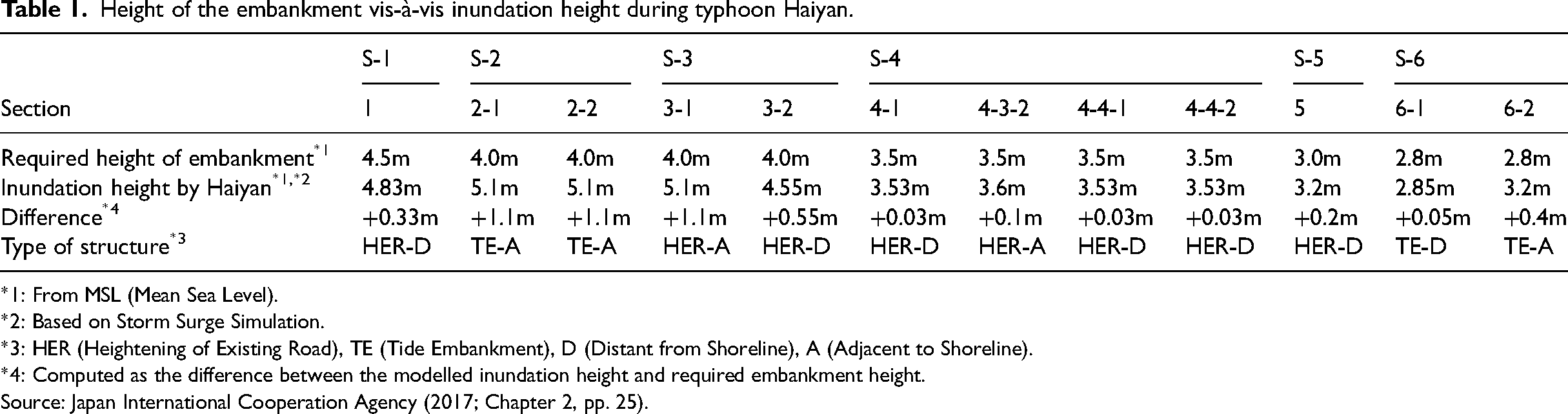
*1: From MSL (Mean Sea Level).
*2: Based on Storm Surge Simulation.
*3: HER (Heightening of Existing Road), TE (Tide Embankment), D (Distant from Shoreline), A (Adjacent to Shoreline).
*4: Computed as the difference between the modelled inundation height and required embankment height.
Source: Japan International Cooperation Agency (2017; Chapter 2, pp. 25).
The LTEP's narratives of protection overlook unintended ecological consequences like “disruptions to inland drainages, wave dynamics, and coastal sediment budgets” (Yamada et al., 2018: 86). Civil society groups in Tacloban, such as People's Surge, Centre for Environmental Concerns (CEC), and Advocates of Science and Technology for the People (AGHAM) contested the embankment's negative impacts on mangroves and vegetation (Center for Environmental Concerns, 2016). There are also other operational concerns that have largely been overlooked. Despite recent construction, some sections already show signs of failure, with residents complaining: “the water still overtops the seawall and floods our barangay” (interview, 1 July 2024). Another claimed: “I don’t think the seawall can fully protect us from another Haiyan. This is why we still evacuate” (interview, 5 July 2024). The DPWH acknowledges some local contractor issues that left certain sections of the embankment incomplete. An officer shared: “there is one gap here, in subsection 4.7. It was left by the contractor with only 40% completion only. It was terminated but we went for a [legal] case… It is now in the Supreme Court” (interview, 15 June 2024). Project proponents attempt to hide these ecological risks and operational failures of the embankment from the public, instead emphasising the project's success and projected benefits.
The technical functions of the LTEP demonstrate how infrastructure projects become sites of contested visibility, where some narratives are strategically amplified while others are deliberately obscured. Through repetitive messaging across various platforms, project champions constructed a dominant discourse of protection while hiding the project's technical limitations and operational failures. This selective visibility highlights how infrastructures are political, serving to legitimise the project and silence opposition despite clear evidence of its shortcomings. This emphasis on the LTEP's technical benefits works as a powerful tool to advance broader development agendas that shape political discourses and public perceptions, as shown in the next section.
Semiotic functions of the LTEP
Alongside its contested technical and protective functions, the LTEP also carries symbolic meanings and representations. For its project proponents, the embankment embodies multiple dimensions of ‘modernity’ and progress. First is the deployment of large-scale engineering solutions, reinforced through curated social media content, such as in Premium Megastructures Inc. (2018) Facebook reel referring to the LTEP as “The Great Wall of Leyte… that safeguards communities and embraces a wave of progress!” The strategic use of terms like “The Great Wall” evokes images of monumental architecture that positions the LTEP as an icon of engineering advancement. In addition, local voices endorsing the project are strategically included, such as in DPWH's Facebook video showcasing a local fisherman expressing a feeling of safety after the embankment has been built, with a caption: “The LTEP is a sign of progress from a good project” (DPWH, 2021). This helps create an impression of local support while neutralising potential criticism from coastal communities. DPWH's (2018, p. 20) statement that “the embankment project will help Haiyan survivors regain their confidence and be economically and industrially progressive” also illustrates a post-disaster recovery approach that privileges large scale infrastructures and commercial development.
The LTEP serves as a symbol of modernity that positions the Philippines as an international partner of countries that have advanced engineering expertise. The local government deliberately foregrounded the collaborations with international consultants and stressed the Philippines’ ability to engage with technological sophistication and work alongside countries traditionally deemed as engineering leaders. As Tacloban's city engineer explained: “We have worked with several consultants on this—Japanese, Dutch, Koreans, and Germans—to ensure the project's success” (interview, 25 June 2024). Interviewees from the government drew parallels with the Filipino culture of ‘Bayanihan’ (working for the common good of the people) and emphasised the extent of local collaboration within the LTEP. They asserted that the project is led by a management committee comprised of the local government and national government agencies such as DENR and Bureau of Fisheries and Aquatic Resources. Through both international and local collaborations, the LTEP serves as a symbol of the Philippines’ emergence as a ‘modern’ nation capable of collaborating with world leaders and executing complex engineering projects at international standards. In doing so, it reflects modernist logics where progress is understood as linear, universal, and achieved through expert-driven technological solutions (Dye, 2016).
Project champions also envisioned the LTEP as a symbol of the city's modernisation through tourism development. The project was deliberately constructed as an infrastructural “spectacle”, designed to reshape Tacloban into a tourist hub. Aesthetic features such as solar lighting, brick pavements, and stainless-steel railings were added to make it appealing to visitors. Some of our interviewees likened the LTEP to the San Juanico Bridge, a 22 million USD JICA-funded project during the Marcos Sr. administration in 1973. This parallel positioned the LTEP within a historical narrative of iconic infrastructure projects that have marked the country's path to modernisation (Hawes, 1992). The local government's substantial allocation of PHP 15,000,000 (270,000 USD) to “improve the embankment to provide a place for tourists to engage in recreation and leisure activities” (Tacloban City Government, 2022: 205) further signals its desire to spearhead Tacloban's emergence as an urban destination capable of attracting domestic and international tourists. Residents now use the LTEP as a space for exercise, casual walks, and casual gatherings. This framing of the LTEP as a tourist attraction and a leisure space reflects a broader strategy of using aesthetics to showcase the city's modern aspirations for urban transformation.
While the LTEP promises modernity and its amenity benefits for Tacloban and its residents, it aligns with speculative urban political economies. In the Philippines, as in many Global South cities, infrastructure projects are pursued by political elites to transform their cities into a “world-class aesthetic” (Ghertner, 2015b) that attract real estate development. Although the LTEP was initially promoted as a coastal defence project, the Tacloban government has broader economic ambitions: the embankment is only the initial phase of a larger plan to transform the coastal area into a central business district through land reclamation. More specifically, the LTEP has provided a rationale for a new causeway and a four-lane road embankment that spans 2.56 kilometres to connect the city centre to its airport complex. DPWH affirms: “the vision is not just to build infrastructure, but to build structures that will draw tourists and investments to the city” (Meniano, 2024b). This is already stipulated by the Tacloban City Government (2017: 193): “The Cancabato Central Business District is a planned city extension, which is a combined commercial, financial, trading, and business hub, to rise in the midst of Cancabato Bay” (see also Beltran, 2023).
While this vision of speculative urbanism through resilient real estate development is less widely publicised, residents and communities contest this elitist vision for their city. Our interviewees are concerned that this proposed development will compromise their community's fishing grounds and adversely affect their livelihoods. They fear that this new development will impede their access to the bay, and that the planned dumping of concrete and soil will destroy marine life. One respondent lamented: “the project is intended to be world class, but what about our local communities and ecosystems? Frankly speaking, it's all about money. There is more money in cement than in mangroves, that the government officials can access, from the national to the local.” (interview, 25 June 2024). Respondents also raised suspicion about the political motivations behind the LTEP, explaining how the project is leveraged by local politicians to enhance their public image and popularity ahead of elections. As one interviewee observed: “As the local election draws near, infrastructure projects in Tacloban get fast-tracked, with politicians promising their project will transform our city”. This aligns with broader patterns documented in disaster politics research across the Philippines, where scholars have identified cyclical increases in “wasteful spending” to curry favour ahead of local and national elections (Basilio, 2024). Similar dynamics have been observed in post-disaster contexts, where housing infrastructure has been weaponised for political advantage—offered as rewards to supporters of political elites (See et al., 2025), while deliberately excluding non-supporters from recovery and rehabilitation initiatives (Cuaton et al., 2024).
Additionally, despite claims of extensive international collaboration and partnerships, certain groups claimed that they were not sufficiently consulted about the LTEP. Most of the complaints have come from local universities and NGOs. A researcher we interviewed shared: “We expected that they would consult the local universities, but there was nothing” (interview, 25 June 2024). This signals a gap between policy and practice, as Section 2c of the Local Government Code (LGC) of 1991 requires project proponents to “consult NGOs and other concerned sectors of the community” before any infrastructure project is implemented (Venugopal, 2016: 1). Among those consulted, many described the process as tokenistic: “they only invited people who were already in favour of the project. If you are known for opposing government projects, you were not invited” (interview, 22 June 2024). Dissent has surfaced from within the local government itself, revealing that the appearance of unity as an illusion. A respondent from the City Environment Office remarked: “Maybe they invited other departments but my office was definitely not invited” (interview, 30 June 2024). Indeed, an NGO in Leyte has recently been red-tagged as communist and had its bank account frozen for voicing opposition against the LTEP (Gabieta, 2024). This reflects a broader pattern where those against mega infrastructure (e.g., hydropower dams) and environmentally destructive projects (e.g., mining), have been kidnapped, illegally detained, and even killed, making the Philippines the deadliest country for land and environmental defenders (Del Bene et al., 2018; Smith, 2022).
These findings indicate that contestation in Tacloban is not only centred around the construction of the LTEP, but also the delegitimisation of differing political voices and public concerns about what constitutes a sustainable climate adaptation project (Del Bene et al., 2018). For example, the LTEP's hasty approval and construction diminished opportunities for engagement, or proposals for alternative protective measures, from local communities and governments. Approvals were rushed to ensure that project funds were spent within the calendar year of the project, according to national budgeting requirements. This haste left staff within DPWH frustrated. One remarked: “The people had really no choice because the funding has arrived, so the project had to start. It actually made me upset because this is such a massive project” (Personal interview, 10 June 2024). Another respondent highlighted the multiple pressures the DPWH faced—from the national government, various cabinet members, local government, and the private sector—to expedite the project. The sense of urgency led respondents to question the rigour of the feasibility studies. A DPWH official admitted that the feasibility study was “compressed so that it would immediately be funded and implemented” (interview, 11 June 2024). Another city official humorously noted that the environmental impact assessment (EIA) had to be in the government's ‘flavour’, that is, it needed to conform to the government's expectations and visions in order for the assessors to secure their payment.
The LTEP emerges as a symbol of modernity at the intersection of advanced engineering solutions, technical expertise of global cooperation, and tourist aesthetics. It aims to make Tacloban ‘modern’ through processes that oscillate between visibility and invisibility. Project proponents make visible certain symbolic elements of LTEP, such as advanced engineering expertise, international partnerships and leisure functions. Simultaneously, it conceals the broader economic ambitions and visions of speculative urbanism by the local elites, while undermining advocates who highlight the LTEP's lack of adequate consultation and adverse socio-ecological consequences. Together, these dynamics of visibility and invisibility carefully curate an image of the LTEP as a necessary form of protection and marker of modernity.
Aesthetic functions of the LTEP
The LTEP is a hyper-visible form of infrastructure that supports the modern aesthetic imaginaries of the city advanced by the local elites. Before Haiyan, the urban poor inhabiting the coastal zone were framed as the source of environmental degradation in the city and were targeted for eviction by the local government (Iuchi and Maly, 2016). Their high population density and the use of light materials in construction contributed to the classification of households as informal and out of place. Although these designations meant that the communities did not align with the world-class aesthetic and global city aspirations of Tacloban, the city government did not have the legal basis to evict them. Officials attempted to relocate the residents to the northern fringes of the city but were unsuccessful. An anti-resettlement alliance was formed among informal settlers and coastal residents (Alburo-Cañete, 2022).
Typhoon Haiyan eventually provided a justification and a sense of urgency among government officials to clear the coastlines of the informal settlers. According to Yee (2018), high risk areas were mapped by the national government in tandem with international agencies such as the United Nations Human Settlement Program (UN Habitat) and Japan International Cooperation Agency (JICA). Hazard maps were subsequently posted in Tacloban's city hall, and coastal areas were colour coded in red to render risk more visible. Legal ordinances were issued that prohibited people from rebuilding near the coast. Beyond concerns of safety, city officials also framed the post-Haiyan reconstruction process as a chance to re-order and beautify the coastline (Su and Le Dé, 2020). In this framing, the removal of informal settlers was essential (Yee, 2018).
Conversely, the materiality and visibility of the LTEP provide a sense of security to some local residents, encouraging them to believe that the project will protect them from future storm surges. An interview respondent shared that the embankment “reminds us that there is that ‘thing’ that keeps the water away from our houses” (interview, 25 June 2024). The embankment serves as a performative object (Wade, 2019), symbolising a massive barrier of concrete that will prevent the waves from reaching their community. For the aesthetic valence of the infrastructure, what matters most to coastal residents is the heightened sense of security rather than its effective protection. Another interviewee mentioned: “after the construction of the embankment, my family can sleep peacefully at night even during typhoons” (interview 26 June 2024). Moreover, the LTEP gives the feeling that local and national politicians are acting against climate change, keeping their campaign promises, and working to improve the city. As an interviewee remarked: “Election season is coming. The best way to show you’ve done something is through infrastructure” (interview, 28 June 2024). The use of concrete in major infrastructures such as the LTEP, is an example of how the materiality and “concreteness” of the seawall project reinforces the Philippines’ postcolonial aspirations for modernity embedded in the narrative of environmental safety (Placino and Rugkhapan, 2024). This privileging of concrete as a construction material for climate adaptation projects can also be observed in post-disaster housing, where concrete houses are perceived as both safer and a sign of progress (Venable et al., 2020).
The LTEP is more than just a protective barrier, however. It has additional design functionalities that make it alluring to local elites and align with a world-class city aesthetic. JICA set the “crest width at 4 metres so that it can be utilised as a promenade and a cycling road” (Japan international Cooperation Agency, 2017: 4–19). The embankment has also been adorned with solar streetlights and other road safety devices. City officials implemented reforestation projects along the coastal area to make the project appear more environmentally friendly. The local government has permitted commercial establishments that align with their visual aesthetic to remain in place, including mini beach resorts, cafes, and food stalls, while evicting informal residents. These aesthetic features serve a dual purpose: they create an aesthetically appealing landscape as well as convey the city's aspirations for modernity. There is a tight overlap between the symbolic and aesthetic components of the LTEP, which reinforce each other to produce specific visions of urban development.
Meanwhile, informal settlers were considered by the local government to be obstructions to the modern aesthetic register of the city and were subsequently relocated to the north. Yamada et al. (2018) estimate that around 14,000 households were displaced by the LTEP, and a further 700 households will be displaced by the on-going Cancabato causeway. Yee (2018) uses the term “bourgeois environmentalism” to describe how the government's post-disaster reconstruction plans, such as the LTEP and the Cancabato causeway, prioritise elite designs for aesthetically modern urban spaces. This is evident in how a city official described Haiyan: “even before the typhoon, these illegal settlers have been a pain to relocate. How I wish a typhoon could wash them out, and that's exactly what Haiyan did” (Personal interview, 26 June 2024). The city's recovery was premised on urban renewal based on the removal of informal settlements along the coast. This also ‘freed up’ land to be used for environmental and economic revival. However, redevelopment premised on dislocation and displacement obscures the sense of identity, place, livelihoods, and social networks that informal settlers have cultivated over decades of living along the coastlines. In response, some residents established dual forms of residence—maintaining a presence in both resettlement sites and coastal areas—while others redefined their concrete houses as temporary evacuation shelters and insisted on staying by the sea, fearing hunger and loss of livelihood more than future typhoons (See et al., 2025).
The aesthetic component of the LTEP reveals how infrastructure projects become sites of contested visibility, where certain visions and elements are deliberately foregrounded while others are obscured. The highly visible components of LTEP, such as its solar lighting, green spaces and walkways, perform a specific aesthetic of urban development that aligns with elite aspirations for a global city. However, these visions are relationally constructed through the forced eviction of informal settlers who were deemed incompatible with such developments. More broadly, the politics of aesthetic (in)visibility illustrates that disasters can be mobilised to justify aesthetic transformations that privilege urban futures aspired for by the elite while systematically excluding those from marginalised groups.
Infrastructural politics of (in)visibility in the global south
This paper examines the enduring popularity of hard infrastructures as a form of climate adaptation against coastal hazards. We consider the question: if hard protection often does not perform to an expected standard, and has a wide variety of negative social and environmental impacts (Klöck et al., 2022; Piggott-McKellar et al., 2020), why does it continue to be so popular? Utilising the Leyte Tide Embankment Project (LTEP) in Tacloban City as a case study, we show how a public image of the infrastructural intervention as technically advanced and offering protective security, entrepreneurial opportunities and modernisation is cultivated and mobilised by project proponents, while the uneven impacts and design shortcomings are concealed. We refer to these two simultaneous processes of making visible and invisible as an “infrastructural politics of (in)visibility”. By selectively highlighting certain aspects of the project while concealing others, project champions shore up the LTEP's image and perceived benefits while masking its socio-economic and environmental impacts. An infrastructural politics of (in)visibility enables infrastructure projects like the LTEP to retain their allure and widespread appeal despite their flaws and uneven consequences.
The infrastructural politics of (in)visibility is shaped by multi-scalar power dynamics that link global and local interests in complex ways. The LTEP exemplifies how hard infrastructures in the Global South embody symbolic aspirations beyond its technical functions. At the global scale, LTEP represents the quest of Global South nations to gain recognition within prevailing geopolitical structures through the adoption of “modern” infrastructure solutions. Concrete, as a material symbol of modernity and progress (Haines, 2011), is central to this politics of (in)visibility as its materiality and presence are mobilised by local elites to signal development and technological sophistication. Strategic cross-scalar alliances between Japanese contractors, national and local government entities, and local contractors make the design and implementation of the LTEP possible. At the local level, Tacloban's government embraces this infrastructure-driven development to generate revenue and craft political alliances. The infrastructural politics of (in)visibility thus operate across scales, with global ideas and imaginaries materialising in concrete forms (literally) that affect people's lives and social worlds at the local level.
This politics of (in)visibility is actively produced and maintained by a diverse constellation of actors, including local and national government, contractors, entrepreneurs, and media. They selectively emphasise aspects of the LTEP that align with narratives of security and urban development, collectively normalising infrastructure as the preferred solution to the impacts of climate change. JICA, the national government (through DPWH), and local government highlight the potential of the LTEP to protect Tacloban from future storm surges. Project contractors and business owners also frame the project as a symbol of modernity and progress, akin to other infrastructural projects that serve as a tourist destination in the province. Local planners and officials also position the LTEP as part of a broader vision for urban renewal and economic growth that will transform Tacloban into a world-class, green coastal city. Media coverage, external consultants tailoring EIAs to fit state agendas, and the collaborative work between Japanese and local contractors amplify and sustain this image. The result is a hyper-visible infrastructure that performs not only protective functions but also political and symbolic ones, reinforcing long-standing modernist paradigms that equate nation-building and progress with the construction of large-scale technical infrastructure.
At the same time, undesirable’ components of the LTEP are deliberately rendered invisible. JICA and the government's emphasis on its protective capabilities and durability obscures the other risks posed by the LTEP, including ecological disruptions and operational failures. Modernist visions and promises of progress advanced by project contractors and local business owners are smokescreens for upcoming land reclamation that, they hope, will transform the coast into a central business district. The imperative to “clean” the coastlines to adhere to world-class aesthetics provides an impetus for the local government to relocate informal settlers away to the city's northern fringes, far from their sources of livelihood and social connections. Colven’s (2020) observations in Jakarta, our findings highlight the relational nature of the visibility and invisibility of infrastructures. What is rendered visible within the LTEP draws attention and political will away from what is rendered invisible. In a similar way, LTEP displaces undesirable visible elements such as informal settlers through relocation to the north. Focus and attention have been accorded to the LTEP and its projected co-benefits and success stories, while the marginalisation and dispossession engendered by the LTEP are regarded as unavoidable consequences of protection and modernisation.
Yet the LTEP is not politically inert. It has become a contested terrain where the politics of (in)visibility are both challenged and re-imagined. Civil society organisations like People's Surge, CEC, and AGHAM have mobilised to make visible the socio-ecological costs of the project, challenging its dominant framings and opening space for alternative imaginaries of coastal protection grounded in social justice and environmental sustainability. Residents have also appropriated the infrastructure in unexpected ways, using the embankment for leisure and socialising, infusing it with meanings beyond state intentions. These contestations highlight that infrastructural politics are never fully settled: they remain fluid and subject to negotiation. As Arnall (2023: 71) explains, hard infrastructures are “ends in themselves… in addition to their more recognised function”. Such contestations are also emblematic of broader dynamics in the Global South, where hard infrastructures serve as arenas through which historical inequities, developmental imaginaries, and visions of modernity are contested and negotiated (Goodwin, 2018; Locret-Collet et al., 2021).
These dynamics are further complicated by the shifting and multi-functional nature of infrastructure itself. The LTEP's technical, semiotic, and aesthetic dimensions are entangled and mobilised differently depending on the context. JICA's claims of the technical functionalities of the LTEP are infused with semiotic meanings, relating to the ability of the Philippines to collaborate with Japan on an advanced engineering project, and aesthetic dimensions such as the construction of the promenade to produce Tacloban as a tourist hub. Similarly, the semiotic and aesthetic components of the LTEP cannot be disentangled from its technical components. Project proponents amplify the LTEP's semiotic and aesthetic functions of modernity, progress, and economic revival, which simultaneously reinforce the project's perceived technical capability as a protective barrier. The relative importance and visibility of each function are also relational and contextual. For example, in situations where the LTEP faces opposition from civil society, JICA and DPWH bolster LTEP's technical capabilities for protection. Similarly, local government and business owners emphasise the semiotic dimensions of modernity and aesthetic visions of a “world class” city when justifying the displacement of informal coastal communities. The various functionalities of the LTEP are contextually deployed—made visible—by different actors to shape public perceptions in favour of the project.
In conclusion, the LTEP illustrates how hard infrastructures for climate adaptation in the Global South are sustained by a dynamic politics of (in)visibility: a process shaped by multi-scalar power dynamics, a diversity of actors with varied interests, and situated contestations. Our findings contribute to the growing body of literature that challenges dominant perspectives of infrastructures as merely planned technical systems (Carse, 2012; Colven, 2017; Harvey and Knox, 2012) and the depoliticisation of climate change adaptation (Eriksen et al., 2015; Mikulewicz, 2019). We argue for an expanded understanding of infrastructures as not only comprised of their constitutive material elements, such as cement and wires, but as relational entities shaped by interactions between multiple actors, technologies, and power. Unpacking these dynamics is essential for understanding the allure and popularity of hard infrastructures for climate change adaptation, particularly for Global South cities.
Highlights
Hard infrastructures derive their allure from an infrastructural politics of (in)visibility
Infrastructures have technical, semiotic, and aesthetic functionalities
Politics of (in)visibility frame infrastructures as desirable and effective
Infrastructures reflect and reproduce socio-spatial politics and uneven power dynamics
Infrastructures are tenuous and in a constant state of becoming
Footnotes
Acknowledgements
The authors would like to thank our institutional project collaborator, Eastern Visayas State University, for its support throughout the research project. We are also grateful to the residents of Barangays 89, 90, 83, and 83-A in Tacloban City as well as to the NGO staff and researchers at various Tacloban universities for their participation in this study. Lastly, we would like to thank the three anonymous reviewers whose comments and suggestions helped improve this paper.
Declaration of conflicting interests
The authors declared no potential conflicts of interest with respect to the research, authorship, and/or publication of this article.
Ethics approval
This research received human research ethics approval from the University of Sydney's Research Integrity and Ethics Administration (Application 2023/HE000838).
Funding
The authors disclosed receipt of the following financial support for the research, authorship, and/or publication of this article: This work was supported by the 2024 Collaborative Grant Scheme of the Sydney Environment Institute at the University of Sydney.