
Abstract
A postsocialist, neoliberal space of reform and innovation, of projects and plans for change, the Dâmbovița River is also a space of unbridgeable material and discursive-rhetorical fractures. The river emerges as the socialist anti-natural background for the new prospects of a capitalist re-naturalized entity: its ‘deadness’ necessary for the projected ‘liveliness’ of the future river. To understand the river as multiple we look at how it creates complex and uneven mediations between space and nature, and how environmental, political and economic transformations are intertwined with the river's history. By following the Dâmbovița—historically, theoretically and ethnographically—as it flows through Bucharest, we (re)discover it not just as a multi-layered entity, but also the ways in which it has been framed and shaped materially and semiotically.
Introduction
Bucharest, like many large cities, is crossed by rivers of which the Dâmbovița is the largest and most ‘historical’ one, accompanying the city's slow-paced emergence since the late Middle Ages (Ionnescu-Gion, 1899: 4–5). The second river, Colentina, became part of the city only during the interwar period. As for Argeș, the largest of the three, it still runs outside the city limits, although Bucharest heavily depends on it for drinking and industrial water.
Today's Dâmbovița is a fragmented entity: both a formerly socialist barren but existing river and a productive not yet existing neoliberal-environmental one. It is not merely plural, as in different beings living side by side inside a homogenous time and space, but multiple, existing through complicated relations of interference, inclusion, representation and historical sequence (Mol, 1999). Our aim is to follow the river inside its larger spatial but also historical hydrosocial territory, understanding it as a multi-layered and multidimensional entity—somewhere between seemingly fixed urban hydrological infrastructure and open-ended urban nature (Gandy, 2022).
The Dâmbovița falls in the broader category of urban ‘hydrosocial territories,’ spaces shaped by the interactions of human practices, watercourses, hydraulic technologies, socio-economic structures, and cultural-political institutions. This concept, which strives to bring together ‘the contested imaginary and socio-environmental materialization of a spatially bound multi-scalar network’ (Boelens et al., 2016: 2), is particularly useful here for framing the ways in which evolving imaginaries were fixed in space. The ‘materialization’ of these imaginaries happens through the creation of hydrological infrastructures and environmental subjectivities—constantly challenged by actors and socio-material changes (Hommes et al., 2022: 5).
The notion of contested imaginaries (Hommes and Boelens, 2017: 74), closely related to Sheila Jasanoff's concept of ‘socio-technical imaginaries’ (2015), helps to shed light on the modernist dualities that separate nature and society (Latour, 1993), dead infrastructure and living rivers, obscuring a deeper understanding of riverine hydro-social hybrid worlds. Rather than merely attempting to deconstruct these binaries, which often results in their reproduction on different levels, we adopt an approach that is both historical and conceptual. This allows us to understand the mechanism of material and semiotic fractures and reversals that the Dâmbovița deploys, not merely as a veil that needs to be torn but an integral part of the river's historical existence. We focus on a specific riverine historical and political trajectory, analyzing how different socio-technical and socio-environmental imaginaries were materialized and contested, but also how they framed and enabled each other. Central to our inquiry is the question of what constitutes a ‘living’ river in contrast to a ‘ghost’ river, and how these notions interact historically.
Bucharest's 2012 Integrated Urban Development Plan, part of the main urban planning strategy, overlooks the Dâmbovița River entirely, except for a brief reference to restoring its ‘attractiveness’ (BCH, 2012). However, there were other projects, which pertain to a larger middle-class process of re-imagining cities and nature (Gandy, 2022; Jorgensen and Keenan, 2011; Stoetzer, 2018), that attempted to reframe the Dâmbovița as a ‘creative’ river, to be liberated by re-naturalization and reintegration into new, ‘smart,’ capital accumulation urban cycles.
For example, in 2019, one of the mayoral candidates, a former NGO activist, 1 who eventually won the election, proposed to turn the river into a ‘creative axis’ for Bucharest. By early 2023, a large alliance had emerged, bringing together Bucharest's local government, local governments of neighboring villages, the Ministry of Regional Development and Public Administration, the ‘Romanian Waters’ National Administration (RWNA) that manages the country's water basins, Apa Nova, a French supplier of drinking water and wastewater treatment services in Bucharest, Metrorex, the national subway operator, and several large NGOs focused on urbanism and ecology. They all agreed to embark on a large-scale project around the Dâmbovița River, aiming for ‘urban integration,’ ‘cultural catalysis,’ and ‘technological innovation’ (Novăceanu, 2020).
However, in May 2023, Bucharest's General City Council refused to approve the preliminary version of the project, making a point of its vague purpose and unclear future management. A tangle of administrative structures oversee the Dâmbovița: RWNA manages the channel bed and the dams, the underground channel running under the river is used by Apa Nova, while the Lakes, Parks and Recreation Administration—or, in some cases, the district-level city councils—is in charge of its levees. The fences and the nearby sidewalks or streets are managed by Bucharest Streets Administration, and the bridges are split between RWNA and the General City Council. 2 Any infrastructural change has to be vetted by Metrorex, as the subway runs very close to the river.
More than just a huge administrative challenge, the Dâmbovița emerges as a multiple entity. The river is subject to various institutional, legal and moral interpretations and judgments, each attempting to map it, to place it within one or another urban and infrastructural frameworks. Competing cultural, technical, historical and political imaginaries shape debates over its role as a central urban hydrological infrastructure. At the core of these contestations lies a deep fracture, one that goes across all of the river's ‘ontologies’ (Boelens et al., 2023), its bareness and productiveness, its being both an enduring infrastructural ghost and a new—yet unachieved—environmental river.
The discursive space surrounding the Dâmbovița is populated with images of innovation, green-blue infrastructures and cool, breezy spaces, all the while hovering above a seemingly lifeless watercourse. Since the 2010s, local administrations and middle-class ecological associations have revived historical narratives of the river. Most projects engaging with the Dâmbovița frame its ‘crisis’ as part of a larger urban one, and use it as a discursive tool to justify the reinvention of the postsocialist barren river—setting out to bring it back to life within the cycles of capital accumulation and contemporary urban aesthetics.
This strategy is not new as it may seem. Similar discursive shifts have occurred since at least the nineteenth century. Even under socialism, beginning in the 1950s, the activity surrounding the historical-natural river was contrasted with the wasteland that the river was in the interwar capitalist period. In 1952, an influential urban planning document, issued by the Central Committee of the Romanian Workers’ Party, blamed the interwar bourgeoisie for transforming the Dâmbovița into a mere ‘drainage channel for the city's filth, buried under a reinforced concrete slab in the city center, depriving Bucharest of one of its main elements of natural beauty’ (Arhitectura și Urbanism, 1952b: 4). This degradation was attributed to the ‘cosmopolitanism’ of a bourgeoisie accused of selling out to ‘imperialist interests,’ and not caring enough about the city and its infrastructure. Under socialism, the river was to be revitalized, surrounded by gardens, monumental buildings, and flower beds, and made navigable (Arhitectura și Urbanism, 1952a: 36).
As Chelcea and Druță argue, even after the postsocialist ‘transition,’ a form of ‘zombie socialism’ persists as a central mechanism ‘in the production of neoliberal monoglossia and guilt by association for those who challenge the dominant wisdom of trickle-down economics, thus supporting the worldview and, ultimately, the interests of the winners of post-1990 transition’ (2016: 522). Following this perspective, we argue that the Dâmbovița emerges as the socialist anti-natural background for the new prospects of a re-naturalized and capitalist entity: its deadness necessary for the projected liveliness of the future river.
This duality is further compounded by a physical fracture: since 1986, an underground collection system has run beneath the river. More than just a sewer conduit, this subterranean river constitutes a form of hidden urban leakiness—one that complicates the historical-political binaries of socialist ghosts versus postsocialist capitalist nature and creativity.
This paper investigates the Dâmbovița River from an ethnographic and historical perspective. Using the ‘hydrosocial territories’ framework alongside a semiotic-historical analysis, we explore how the river has been continuously framed, contested, and reshaped. Our research is based on three years (2022–2024) of ethnographic fieldwork and archival research. We employed (participant) observation and visual documentation (photography) of the areas alongside the river, both in Bucharest and its outskirts (Roșu, Chiajna, Glina, Mogoșoaia, Străulești, etc.). Fieldwork was conducted across multiple temporalities—seasonal cycles, discontinuous intervals of everyday urban life, and during curated events of urban regeneration.
We did archival research in the Romanian National Archives, tracking the river's histories in scientific journals, newspapers, and biographies. In 2022 and 2023, we conducted interviews with neighbors, inhabitants of the riverine or neighboring areas, and fishermen (around twenty-five interviews both recorded and not recorded), continuing seasonal monitoring of sections of the river. From 2023 to 2024 we continued to do interviews with riverine community members (twelve), and we also interviewed experts and NGO activists from: Ivan Patzaichin-Mila 23 Association, Maker @NDL, NodMakerspace, Văcărești Natural Park Association, Rețeaua pentru Natura Urbană (The Network for Urban Nature), and the Consultative Council for Durable Development. We monitored the General City Council meetings, grey literature (policy, working papers, and reports), and media reports on the topic of the Dâmbovița River starting with 2020.
The overflowing and scarce river
Historically, the Dâmbovița has brought life and joy as well as spread diseases, misery, and death, as it has meandered and constantly changed shape following the first slow- then very fast-paced growth of the city—in turn profoundly shaped by the floods and droughts caused by the river.
Caught in a dialectic of too much and not enough, the river's human-inflected history became articulated with its hydrological and geomorphological trajectories. The city emerged on the left bank of the Dâmbovița, facing, fighting and using the ponds, marshes and swamps that the river generously and maliciously created around it. On the right bank there were numerous ponds fed by small streams that used to flow into the Dâmbovița, including small islands that gradually disappeared in the late nineteenth century (Georgescu et al., 1966: 109).
Starting with the eighteenth century, the river's entanglement with human activity became increasingly visible. First came the mills, droughts, and floods. In June 1794, the river dried up so much that the water no longer reached the town, as it became ‘a trickle of water that you could jump over.’ After some investigations, it turned out that some mill owners (local aristocrats and monasteries) had deviated the river at its source to keep their mills operating during a drought (Giurescu, 1941: 5).
Every large church or monastery on the river banks owned mills, which often competed with each other. Most of the floods were related to the activity of the mills, pitting some of the big landowners against the rulers of the country who threatened and sometimes even destroyed the mills. The Dâmbovița mediated and embodied even more social and economic conflicts in the nineteenth century, with inhabitants of the riverine neighborhoods fighting with the mill owners when the floods became very frequent. As people living near the river began modifying the embankments, processes of erosion ate up the land on the adjacent bank, creating a continuous confrontation field over and around the Dâmbovița.
The water of the river could be ‘sweet and gentle’ or ‘crazy, filled with Danube waves’ when it flooded not only the slums but also the central parts of the city, filling up the lakes, reaching the walls of the governmental buildings, and then spilling out onto the plains ‘carrying with it the stumps …, the beams of the bridges and the houses of Bucharest and—how many times!—a child's crib or a basket with a hen still on the nest’ (Ionnescu-Gion, 1899: 307–308).
Stefan Dietrich, Captain in the invading Austrian army, saw not a ‘sweet and gentle’ water, but a ‘disgusting’ river in 1854: ‘A winding and rather large river rolls its muddy waves through the city, its water being sold for drinking and cooking, although the sewers discharge into it. Its disgusting banks are connected by shabby wooden bridges’ (Popescu, 1935: 95).
The Dâmbovița was not just an unruly force and the supply for the local economy (mills, tanneries, and vegetable gardens), but also the main source of drinking water for the city, and a mediator of geographical and social economic relations and fractures. There were some cisterns and running water pipes as early as the mid-eighteenth century, but very few people had access to them. Most of the population relied on the water carried from the river by water vendors (ro, sacagii), with their barrels placed on two-wheeled wooden carts, pulled by a horse or donkey (Georgescu et al., 1966: 10; Potra, 1981: 119) (Figure 1).
Episode of inundation in Bucharest: Prince Alexander visits the Tabaci neighborhood, L'Illustration, Journal Universel, XLIV, 1864, p. 69.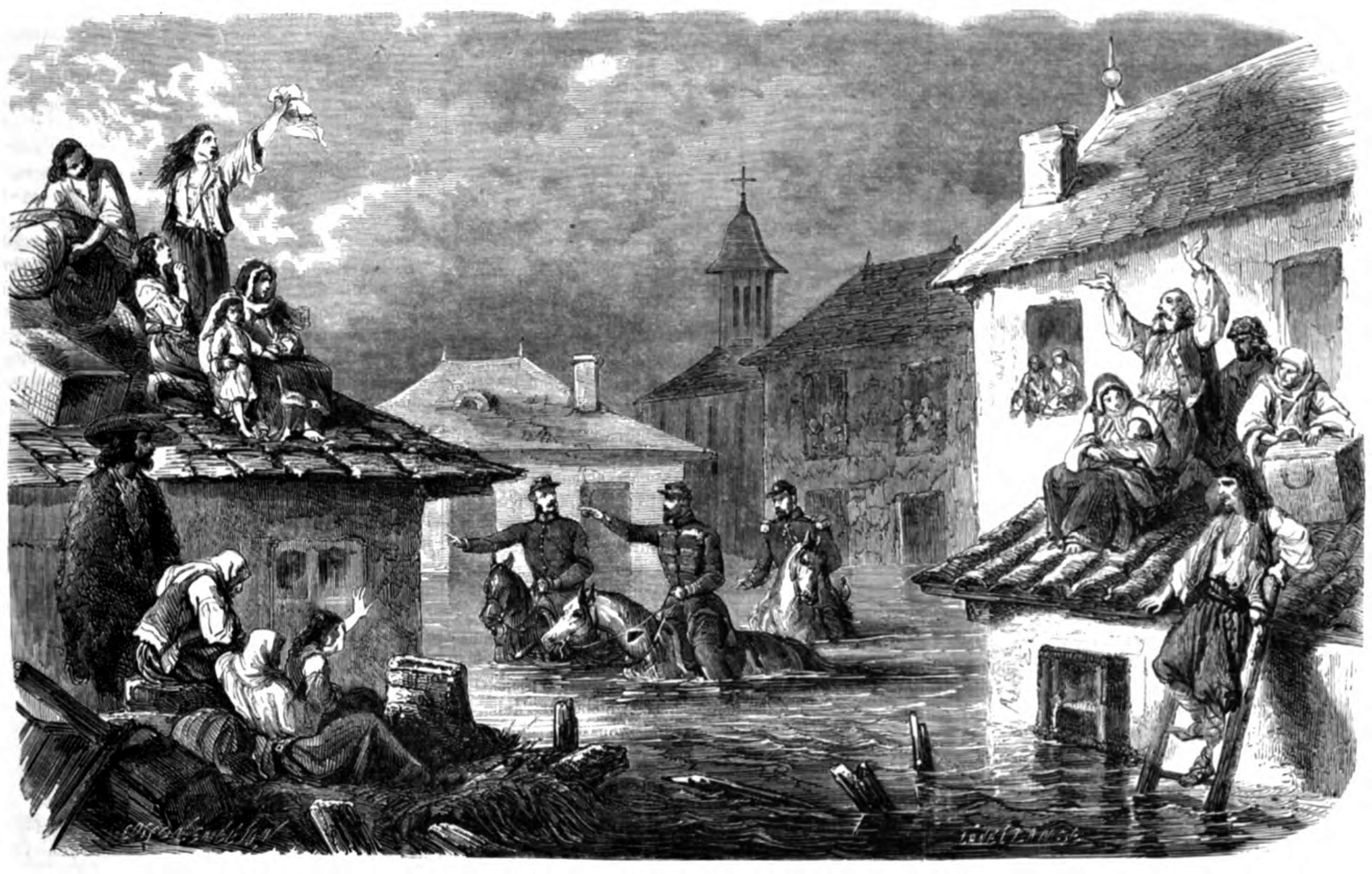
The problem of floods and access to drinking water spilled over in a flurry of projects to regulate and police the river. By the mid-nineteenth century, the number of mills increased to almost fifty. In 1864 and 1865, Bucharest suffered from massive flooding: [i]n past centuries, as in our century, city dwellers became sailors by necessity. And in 1774, as in 1805, as in 1864 and 1865, boats, large and small, rafts, broken bridges, and large troughs floated down the streets, just like the gondolas flow along the streets and the roads of Venice …. The shouts of the boatmen, the wails of the terrified … alternated with the shots of rifles and pistols fired by those who called for help from afar. (Ionnescu-Gion, 1899: 308)
That same year, during excavations for the construction of a bridge near Văcărești Abattoir, on the south-eastern periphery of Bucharest, another kind of water surfaced. Three clear cold mineral water springs, with a reddish sediment, were discovered there (Bacalbașa, 2014: 136). The ferruginous water from the springs boasted therapeutic properties, especially good for patients with anemia and digestive system diseases (Brătescu, 1970: 60).
In the middle of the slum near Văcărești Abattoir, in one of the less desirable parts of the capital city, a spa resort flourished catering to those Romanians who wanted to be in tune with the European fashion of going to spa towns. The more popular the springs became, the longer the list of illnesses that the miraculous Văcărești springs could treat grew. The news of the mineral waters spread rapidly throughout the capital, and the townspeople rushed to taste the novelty, even hindering the work on the bridge.
In the following year, the area of Văcărești became a big social attraction, surrounded by marshes and garbage dumps (Cotoi, 2021). Historical developments in the city's transport infrastructure emerged to facilitate access to the springs; in 1872, the ‘American iron road’ was inaugurated, namely the first horse-drawn tramway in Bucharest, which ran from the center of the city to Văcărești. Alleys were laid out, kiosks were set up, vendors of all kinds of merchandise built shacks, and outdoor restaurants appeared. The people of Bucharest and beyond flocked to the treatment with ferruginous waters while the brass band played twice a week and doctors worked in shifts giving balneological advice and consultations (Vasilescu, 1965: 214). In 1872, Matei Millo, the director of the National Theatre and its most famous actor, wrote the very successful variety theater play The Waters of Văcărești: ‘Ah! What wonderful waters/ The waters of Văcărești/ They heal many sins/ And marital shortcomings!/ Come on, come to Văcărești!/ To cool your soul/ And drown into those tempting eyes/ That can even burn your heart!’
The plans to transform Văcărești into a balneotherapy resort gained traction, and patients flocked for treatment in large numbers—reports drawn up by the doctors at the time show that 3500 patients came seeking treatment every week in 1872, ‘of whom fifty-two left feeling better’ (Vasilescu, 1965: 215). Finally, the citizens of Bucharest had new clean and beneficial waters for drinking and bathing, living, healing waters, as opposed to the dead and polluted waters of the Dâmbovița.
The enthusiasm for the future of Văcărești mineral waters as a great European spa establishment diminished slightly when, in 1872, doctor Nicolae Kretzulescu, one of the city's prominent physicians, commissioned a thorough chemical analysis of the three springs. The results of the analysis were disquieting—the water did not come from a deep underground source as advertised but from the Dâmbovița River; filtered through layers of sand and clay, it acquired the mineral qualities found in the springs of Văcărești (Brătescu, 1970: 61).
Nevertheless, a year later, in 1873, Romania took part in the Universal Exhibition in Vienna with six casks of water from the Văcărești springs and won a silver medal. In the years that followed, plans to turn the Văcărești area into a spa became increasingly remote, and the popularity of the springs diminished considerably—in the season of 1873, only 955 patients were treated with the waters of the Văcărești springs, and, in 1881, the three therapeutic springs dried up completely, due to the regulation works on the Dâmbovița River (Vasilescu, 1965: 215).
Between 1880 and 1886, following a long series of engineering projects, debates, financial problems and corruption scandals, a French entrepreneur started the regulation of the river. It was deepened by six meters, and a wooden oak floor was added in some parts of the river bed. In 1893, after another huge flood, caused by the breaking of an upstream dam, the wood floor was extended to almost the entire length of the river crossing the city (Figure 2).
The project for the regulation and channelization of Dâmbovița, 1881.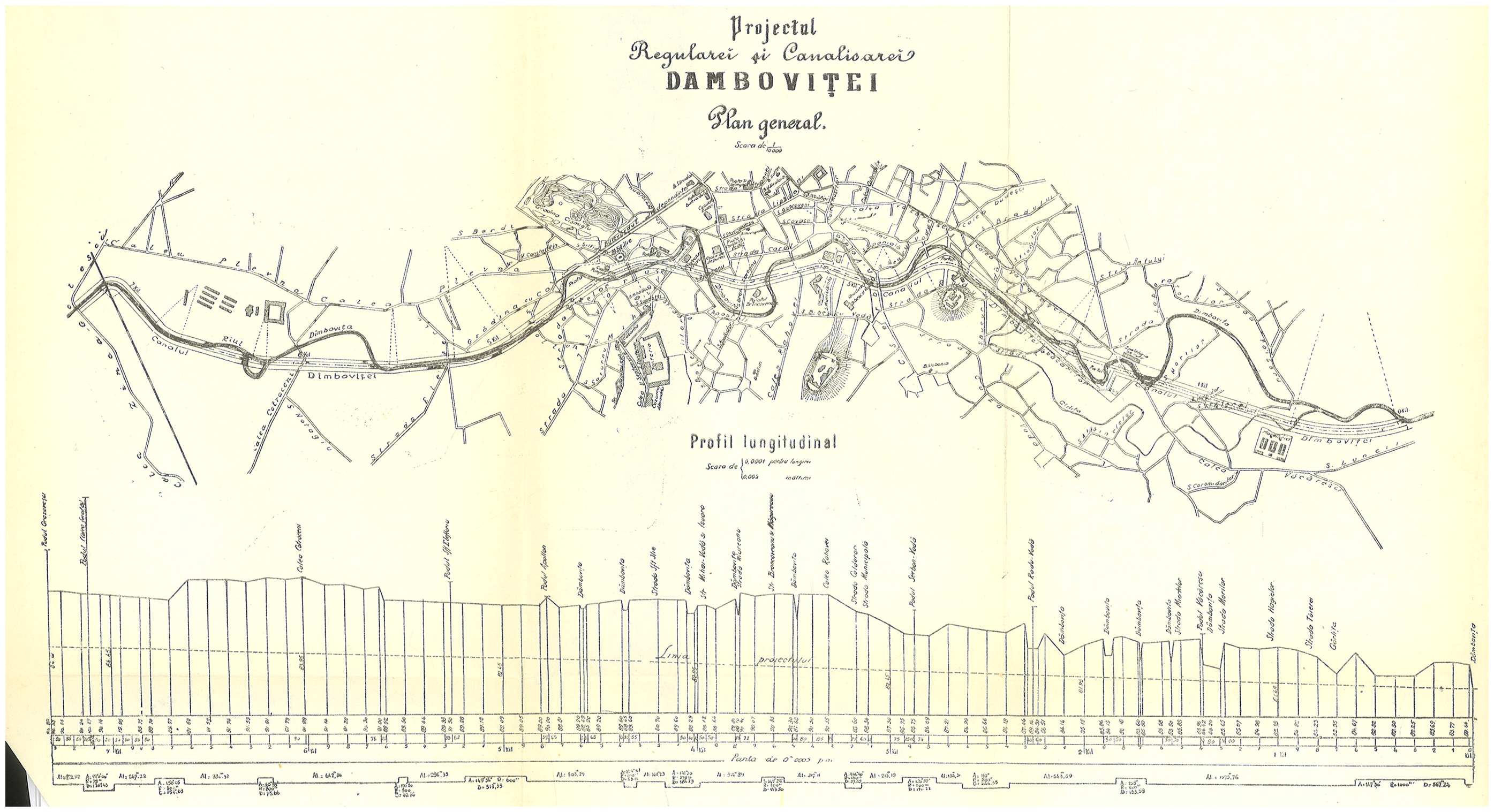
By 1883 Bucharest had become an immense building site. In addition to the new riverbed, 100 km of pipes were installed to supply water to the townspeople, canals were dug on the main streets to drain the waste and water into the Dâmbovița, and the old wooden bridges and piers, along with all the ramshackle constructions on the river banks, were replaced by twelve new iron and stone bridges (Potra, 1981). The ‘sweet’ but ‘disgusting’ river, the natural force that sustained mills, tanneries and impromptu spas was radically reframed by new constellations of hydrological imaginaries.
Building the rivers, making the city
After WWI, Romania almost doubled its territory and population. As the capital of the so-called Greater Romania, interwar Bucharest seemed, now more than ever, in need to be quickly brought up to the technological level of other modern European capital cities. 3
During the interwar period, the old problem of urban water re-emerged inside this new modernization comparative framework. The two rivers, Dâmbovița and Colentina, had to be thoroughly tamed and regulated. Pre-WWI projects were continued and expanded (the sewage network), and new solutions were designed and developed. One thing was unequivocal: the never-ending game of either too much or too little urban water had to stop (Dragomir, 1939). Architectural and urban planning developed alongside the industrialization process in Bucharest, and the main rivers crossing the city, Dâmbovița and Colentina, came again under scrutiny as subjects for technical interventions. The old streams should become, eventually, modern rivers (Caranfil et al., 1936: 8).
Bucharest sprawled, with the parcelization of land in the slums and beyond the city's old limits, eating up the suburban villages. New neighborhoods were planned and built as the population grew abruptly. The horizontal territorial advance (of built-up land for residential use and industry facilities) was accompanied by the vertical development in downtown areas. The new urbanistic and industrial plans and the expansion itself centered on the water issue (Georgescu et al., 1966: 74), namely providing drinkable water, while disposing of waste and bad water.
At least until 1881, the flows of water frequently changed shape and volume causing floods, creating public health problems, and esthetical discomfort for the new, self-consciously modernizing city. There had been an unending struggle with water, mosquitos, malaria, rats, and the overgrown river banks (Dragomir, 1939). The many faces of water and the seasonal character of the streams had turned them into objects of municipal benevolence, materialization of power relations, and subjects of direct hydraulic interventions. Managing water and regulating rivers proved to be very complicated, and projects were debated at length in the absence of clear urban regulations. Many projects lingered for years to be never implemented.
Because of its geographical centrality, but especially of the recurrent problems related to flooding, interventions on the Dâmbovița were given priority (Georgescu et al., 1966: 154), especially as some of the projects had already been started (sewage system, the aboveground bed, construction of bridges, riverbank development, etc.) and only had to be either continued or adapted to new perspectives and requirements. But the expansion of the city, the malaria and rat infestation problems opened up yet another site: the Colentina River. Two directions were debated: (1) its transformation into a channel, used mostly for irrigation—horticulture and small-scale agriculture, and (2) the restoration of the banks, draining of ponds, the creation of new lakes and the connection of Colentina to the nearby Ialomita River by building a dam and a channel (Caranfil et al., 1936; Georgescu et al., 1966: 151). They chose the latter.
In 1926, the drainage and improvement project for the Colentina River was drawn. The future lakes were to serve as water supply for the industry, irrigation, fishing and leisure. When the Mayor of Bucharest announced his intentions and plans for the Colentina, they were considered ‘crazy’ or ‘impossible.’ Passions were running high when he was publicly threatened (by owners of riverine lands), in front of the General City Council, with being shot if he dared to implement the plans. After some compromises, the works started in 1933 (Caranfil et al., 1936: 8).
These interventions created an entirely new geography and landscape in the northern part of the city (Radu and Stoiculescu, 2010), maintained by massive hydraulic infrastructures. The draining of the ponds and marshes had a large impact on public sanitation—eradicating malaria—but also an economic and aesthetic one, reviving ‘large areas condemned to misery’ (Georgescu et al., 1966: 151–152).
In parallel, work continued on the Dâmbovița, whose central part was covered in 1934–1936 with a concrete slab (Georgescu et al., 1966: 145), followed by the extension of the canalization in the western part of the river and the sanitation of the Crângași and Ciurel areas (Gazeta Municipală, 1943: 4). Despite these works, the river continued to pose problems. On the one hand, because the expansion and industrialization of the city required a much increased consumption of water, and on the other hand, because the river was the main supplier of both drinking and industrial waters.
The city's entire sewage system went from 285 km in 1923, to 614 km in 1942 (Giurescu, 1966). The discharge of industrial water into the sewers required an increasing volume of water to dilute the wastewater so that clogging could be avoided: in order to flow in this new modernized regime, the Dâmbovița needed more and more water from other rivers (Argeș). It was becoming a water-consuming river. Its transformations split it into two rivers, by physical duplication, but also by the types of maintenance that each of the two river channels required. More than that, the integration of the Colentina River in the main urban hydrological infrastructure created yet another type of spatial doubling: on the one hand, wastewater, drinking water, promenade on the banks of the Dâmbovița, and on the other, the lakes, fishing ponds, leisure through a democratized access to urban waters on the Colentina (Arhitectura și Urbanism, 1952: 4).
Along with Bucharest, the Dâmbovița was included in the new post-WWI ‘Greater Romania’ modernization projects, which continued and accelerated the fin-de-siècle transformations. The hydrosocial territory the Dâmbovița was expanded to include the second urban river, the Colentina, and, as the sequence of floods and droughts was apparently broken through large hydrological interventions, the river started to consume water from the third nearby watercourse (Argeș).
The socialist (almost navigable) river
The redevelopment of Bucharest after WWII involved a massive deployment of resources, manpower, and expertise. Its transformation into a modern capital would have been the most tangible proof that the new socialist state could deliver on its promises to provide a better life and guarantee a brighter future (Grama, 2019: 32).
In 1949, a team of architects started to work on a plan for the capital that was largely inspired by the 1935 plan for Moscow, and directly benefited from the presence of Soviet experts. In 1959, the authorities declared Bucharest's masterplan completed (Grama, 2019: 34). It set the city limits, its population (1.7 million), as well as two long-term goals: to mitigate the striking differences between the center and the periphery, and to ‘bring order’ to the city. The new mode of total planning directly affected the Dâmbovița River —which underwent a series of systematizations and urbanistic re-organizations. 4
The river was envisaged as part of the major urban functional infrastructure. The socialist approach involved regulating flows to meet water requirements, to expand irrigation and harness hydropower potential, and to mitigate the effects of flooding, quietly continuing the interwar projects. Nevertheless, interventions on the river, during the socialist period, cannot be treated as smooth and totally coherent, even if the Dâmbovița became a highly regulated entity. There have been many debates, in the 1950s and 1960s, about the role that the river should play in the city—from a compositional axis and main trunk line, to a critique of hastily interventions that would break with the nature of the river and produce ‘barren embankments’ (ro, maluri searbăde) (Vladimirescu and Vladimirescu, 1956: 34).
In 1950, in the outline of the Plan for the Systematization of Bucharest, the Dâmbovița River was supposed to be ‘brought back to life and made useful, not to transport sewage but commercial and passenger ships’ (Vladimirescu and Vladimirescu, 1956). On November 13, 1952, the Party Central Committee decided to widen the banks of the river (almost tripling the width) and create a large reservoir in the northern part of the city, to make the river navigable and link it to the projected Bucharest-Danube Channel. The plans included wide stone quays, a river port for passengers and goods, and all the buildings and facilities needed to link the capital to the country's expanded water transport network. Along the Dâmbovița, with the quays once widened and rebuilt, a ‘system of complex ensembles of monumental public buildings and housing and the creation of gardens and lawns with trees and flowers’ was projected (Arhitectura și Urbanism, 1952: 34).
In 1956, a new study for the development of the Dâmbovița (Vladimirescu and Vladimirescu, 1956) criticized the previous methods of urban integration as having ‘not only the most unsuccessful urban effect, but [being] a real danger to life. Throughout the nine-kilometer stretch, the river does not tempt you to look at it, and the water reflects only barren banks and unsightly bridges,’ juxtaposing the present state of affairs with a past of clear drinkable water, ‘life-giving and soul-pleasing.’ Vladimirescu and Vladimirescu's proposal also included the circulation of boats at street level in the central part, giving Bucharest ‘the convenience and beauty of a port city’ (1956: 34–37).
The plans did not materialize as they did not solve the problems that the Dâmbovița was causing, and the principles of horizontal organization of hydraulic functions were considered hydrologically unsound. As an alternative, their vertical organization (already envisaged by interwar engineers) was proposed—instead of flowing next to the developed river, the collected sewage waters were to go underneath it, resulting in the splitting of the Dâmbovița into two rivers: one clean and visible, another dirty and hidden; a concrete aboveground channel with clear water drawn from a projected reservoir, and another underground one to drain the wastewater collected from the sewage system to a large, out-of-town treatment plant (Stematiu and Teodorescu, 2012: 6).
The 1950s brought with them strong criticism of the infrastructural interventions from the interwar period, emphasizing the need to revive the barren river. Interwar efforts were dismissed as futile, the city's development was deemed anarchical, conforming only to the interests of the ruling class. At the same time, there was a tacit yet clear continuity with pre-socialist planning and systematization. Ironically, some of the architects involved in the design of the 1935 interwar masterplan later joined the team working on the socialist masterplan (Grama, 2019: 42; Stematiu and Teodorescu, 2012: 145). A very important part of the socialist image of the ‘living’ river was its navigability—for commercial and touristic purposes alike—and its connection with the Danube, and the Black Sea—another older interwar plan. 5 The dead versus living historical-semantic dichotomy was widely used by socialist planners to put to work hydrological imaginaries that both continued and transformed the interwar projects, without acknowledging any continuity.
Critics of the early 1950s decried the partial burying of the river under a reinforced concrete slab in the 1930s only to return, in the late 1960s and 1970s, to plans to cover up the entire length of the river, and in the 1980s, to the total entrenchment of the Dâmbovița in cemented channels on two levels. What happened?
Investment in cement factories exploded during the socialist period as part of the drive for the standardization of construction. The cement industry in Romania is more than 130 years old (the first cement factory started operating in 1890), and by 1950 the number of cement factories in Romania had grown to ten (Dan and Rohan, 2019). By the late 1950s, the precast concrete industry was growing quickly. 6 Technological innovations in housing construction and the development of the Romanian seaside resorts (beginning in 1955, but picking up pace through the 1960s) also contributed to the context that made it possible to canalize the Dâmbovița River and cast it in concrete. In 1960, ‘the construction system with cast concrete membranes with sliding formwork and prefabricated non-supporting components allowed the record rate of one floor per day’ in building hotels on the Romanian Black Sea coast (Băncescu, 2015: 52).
Urbanization projects and interventions transformed in the 1970s, with the increase of scientific efficiency and methodical precision (Lăzărescu, 1977: 3). This also had an effect on the projects targeting the Dâmbovița. If in the 1950s the ecological or recreational aspects of the river still featured in the discourse, towards the 1970s and 1980s the river became the focus of the total transformation of Bucharest's infrastructure. The ecological intentions of the early socialist period were overcome by investments and technological innovations aimed at changing the infrastructure plans, namely concreting the banks and building the wastewater collection channel.
In the late 1950s-mid-1960s, there were still muted debates around the ways in which (socialist) nature can and should be transformed, going from a strictly extractivist approach, to a more ecologically inflected one. In the specific case of the Dâmbovița, the debate focused on the connection with the Danube, the ways in which the river, and its surrounding city, could be integrated in large hydrological basins and linked to the largest water bodies in Romania: the Danube and the Black Sea.
In the 1970s, Romanian suffered from severe flooding, some of them catastrophic (1970 and 1975), which led to the creation of plans and hydrotechnical interventions nationwide. In 1975, Bucharest itself was flooded. In 1977, a big earthquake made around 1400 victims, buried under the rubble of Bucharest, and while the Dâmbovița did not overflow, the threat of past disasters seemed to warrant dramatic interventions. The river was no longer a natural element in the reforming/urban planning discourses. It was to become a fully controlled component of the urban infrastructure, part of the city's larger system for drinking water, wastewater, and flood control. A more extreme perspective, from 1971, even considered that, due to traffic increase, it was impossible to keep the river as it was, instead the riverbed should be first fully covered by a roadbed and then turned into a general sewer (Abduraim, 1971). It was becoming increasingly clear that the new shape of the urban river would be tiered: on the surface, a concrete bed through which clean water would be conveyed, its level regulated by a series of controlled spillways fed with water from reservoirs; underground, a concrete structure called the sewage collection box to which the sewage system's main collectors would be connected, designed to transport the wastewater collected from the whole city to the treatment plants using a gravitational-flow system (Stematiu and Teodorescu, 2012). From 1985 to 1989, this project was implemented, through a huge infrastructural and building effort, giving the river the aspect and structure it has today.
The fate of Dâmbovița was played on the socialist articulation of two old infrastructural projects. The first is the connection of the city and its small rivers with the big river (the Danube) and the sea. The second, with even older roots, is to ensure access to clean water and flood protection, the eighteenth- and nineteenth-century problem of either too much (floods) or too little (droughts) water.
The 1950s plan to make Bucharest a fluvial port, which was behind the ‘living’ socialist river view in counter-distinction to the old anti-natural capitalist one, was uncoupled from the touristic, urban and attractive river in the 1970s and 1980s. After discussing at least fourteen locations for the port, a location on the city's eastern periphery was chosen. In 1985, the use of prefabricated concrete components made urban Dâmbovița, which was fragmented between successive locks, unnavigable but it seemingly made possible its connection with the Danube (Forgaci, 2018). The plan of linking Bucharest to the Danube, via the Dâmbovița and Argeș rivers, brought with it the demise of the project of the socialist vibrant river.
At the end of the 1989, the Dâmbovița was split between an aboveground river and an underground wastewater system, fragmented and trapped between concrete embankments and hydrotechnical locks, its waters a complicated mix of various flows made up of underground waters, rain, human and animal waste. But it almost connected the city to the sea—and that was to be the epitome of socialist national hydrological development. 7
The postsocialist river for drinking
The navigation project was not totally abandoned after 1989. Between 1980 and 1990, two ports were planned on the outskirts of the city; though much of the plan was actually built, work was abandoned in 1990, and everything quickly turned into ruins (Avădanei, 2012). The project resurfaces frequently in the public debates about the fate of the Dâmbovița, bearing witness to the survival of older tensions and dualities, but the river's projected ‘liveliness’ has mostly moved in other discursive and institutional frameworks.
After the fall of the socialist regime, many voices deplored the poor ecological condition of the river. During the socialist period, the river lost its lush green banks, becoming completely artificial. Articles published in the 1990s harshly criticized the interventions on the Dâmbovița River: ‘Around ten billion lei
8
had been spent on this project by the end of 1989, with a total planned investment of 23 billion lei. From an ecological point of view, the work is a monstrosity’ (Rusu, 1990: 101) (Figure 3).
Maintenance work, 2017.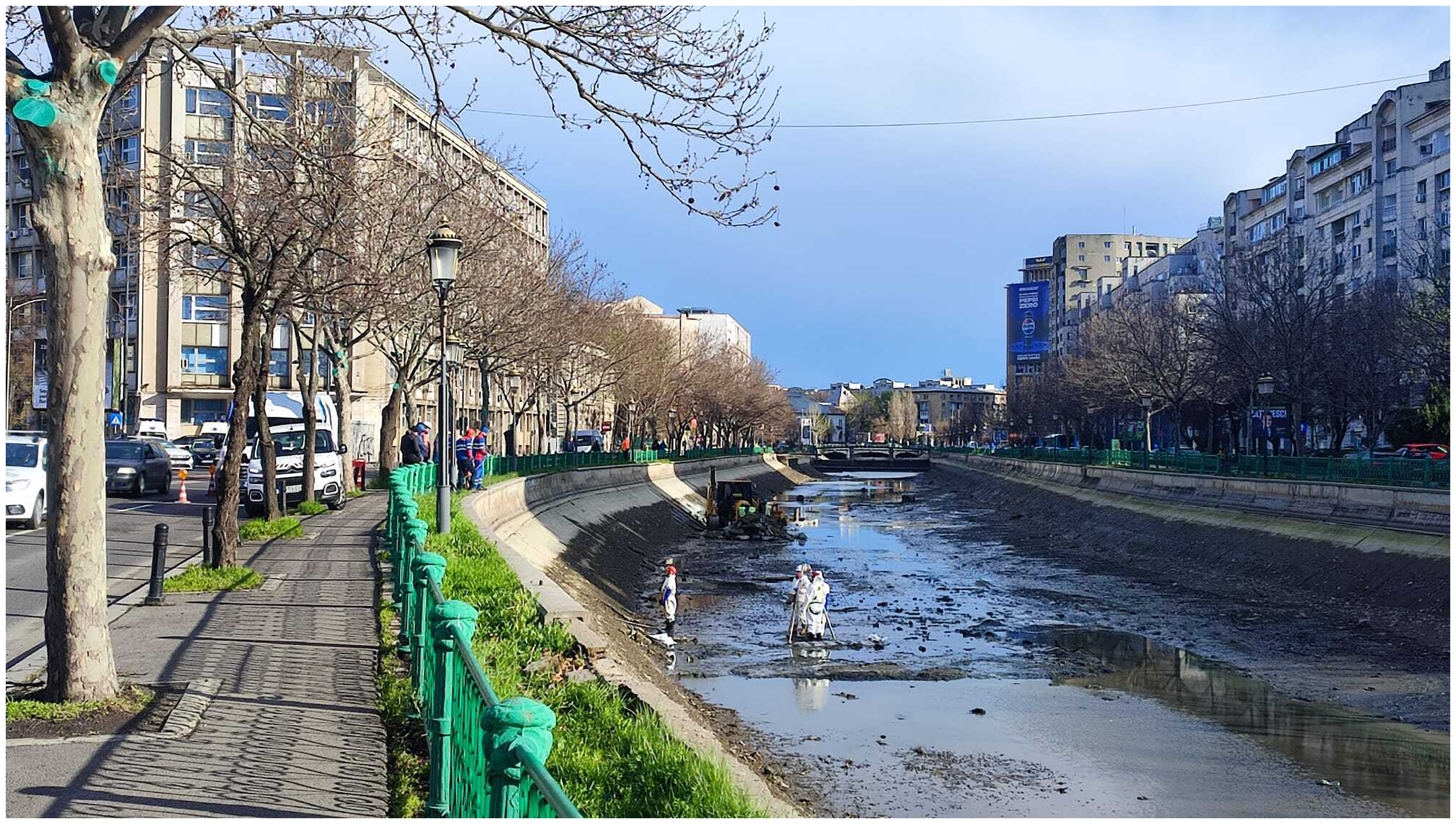
The postsocialist urbanist discourse picks up, unintentionally, the themes of the socialist early 1950s. The old regime had ecologically ‘killed’ the river: ‘[i]f the life of Bucharest was for centuries influenced by the seasonal changes of the Dâmboviţa, determining a natural and organic relationship between the city and its river, the current situation, on the contrary, denies it its value as a natural generative and regenerative element, adapting the shape of the river to the modularity of the precast reinforced concrete panels and solving the inhomogeneity of its form through dams’ (The Romanian Order of Architects, 2020: 3).
In 2015, a huge abandoned industrial space (a former cotton textile factory) was transformed into NOD Makerspace, where architects, visual artists and others created working spaces and, starting with 2017, a library of materials. It was a dramatic change from socialist industrial ruin to a home for ‘multidisciplinary creatives.’ 9 Located right on the bank of the Dâmbovița River, the NOD community, together with NGOs such as Ivan Patzaichin-Mila 23 Association, 10 organized the Dâmbovița Delivery annual event designed as a waste management awareness and education campaign, on and around the watercourse, in the context of the European Sustainable Development Week. The project started from the idea that the Dâmbovița is the largest unused space in Bucharest, the aim of the event being to ‘reclaim the water’ by building pontoons, water sports, shows, music, workshops, and cultural activities (Mischie, 2023).
In 2023, a floating barrier to collect non-biodegradable waste and a cistern with a (filtration-sterilization-osmosis) system for water treatment were installed. Hundreds of kilograms of waste became visible and were disposed of from the river surface, and the water from the river became available as pure drinking water.
Why was drinking water from the river so important, since at least the times of the water peddlers (ro, sacagii) most of the city inhabitants have regularly drunk water from the Dâmbovița? Bucharest's tap water goes through huge invisible and complicated infrastructures and processes that mix the waters from the Dâmbovița and Argeș rivers, and then on to be treated in huge plants, before entering the city's water supply. The newly installed blue drinking fountain on the river bank, with the collected waste in site, bracketed this whole ‘anti-natural’ infrastructure. The relationship between the river and the people continued to be mediated, but both the water (nature) and the humans were supposed to end up modified by their new connection.
The river thus comes to hold both the past—the jolly Dâmbovița of yore—and the future, all due to the power of environmental and neoliberal creativity. The socialist ghost river with its wastewater and concrete corset was re-enacted as potentially vibrant, charming, and drinkable. The people were to be educated and extricated from their indifferent, passive relationship to urban nature and brought in contact with the revivifying waters of the ‘creative’ river. As if, tangled up with the barren infrastructural socialist river, there was a drinkable and natural one that could be saved through smart science and middle-class aesthetics and morality (Winegar, 2016). The relation between the pre-socialist dreary river and the socialist ‘living’ river resembles the present-day fracture between the socialist lifeless Dâmbovița and the future ‘green’ one. The socialist living river is, however, different from the contemporary one, as the socialist planners never dreamt of drinking water directly from the Dâmbovița, understanding its naturalness and usefulness in a wholly different way.
The drinking water project (half-)failed, like most of the various postsocialist public or private projects for the regeneration of the Dâmbovița River—as many unfulfilled promises or, at best, one-off activation events, sometimes repeated annually. But the pontoons on the river remain, used mainly by NOD members and employees, who can have a beer there in the evening, and occasionally by other neighbors, especially during the summer. Some of the anglers that congregate on the banks of the Dâmbovița have also started to tentatively come there. Lately, some people have used them to wash their carpets and, during hot summer days, delivery workers—mostly Sri Lankan and Nepalese—stop by for a quick swim in the river.
In addition to the larger political, economic and cultural-ideological debates, the contested imaginaries that constitute the river, there are smaller practices and ways of enacting and deploying fragile ways of life in relation with and around the river. The Dâmbovița remains a cool refuge from the increasingly hot summers, a place to illegally wash carpets or just socialize, sit still and gather your thoughts away from the hustle and the bustle of the city. The fishermen that use the river are possibly one of the largest urban river communities. They fish for pleasure, and sometimes to make ends meet. Some do not have enough money to fish elsewhere, or do not own a car to get out of the city to the ponds and lakes around Bucharest, where you need to pay for access. The poor and not so poor meet, enjoy each other's company, help each other, use, and fight for the river in many ways.
An old fisherman who likes to fish near the Bucharest Courthouse said: ‘[I]t is so relaxing. Especially in the morning, when they bring the jailbirds to trial. It gives you a feeling… you start to appreciate your freedom, and you do not get upset if you don't catch anything’ (Popa, 2020). Another posted a video after his first catch in the river, where he kept mumbling: ‘It's unbelievable, my hands smell of fish!’ Others make jokes about another type of catch, elegant women passing by in the central parts of the city. The anglers get into arguments with people using illegal nets that trap and kill not only fish but also birds; some fish in the daytime, others during the night hours (when the subway is not running). There are hundreds of online videos and debates about the good places and the cleanliness of the river, and there is even an informal association of ‘poor fishermen’ (ro, pescari amărășteni). 11
Contemporary Dâmbovița flows inside a differently shaped hydrosocial territory, but still part of the complicated historical-semantic rift and dynamic between the ghost and the living rivers. At a closer look, amidst the present-day powerful environmental-oriented imaginaries and the active historical (mis)shaping of the past there is an audible murmur of the ‘unaccounted for, unnamed, and whose fictions are only registered as noise’ (Swyngedouw, 2009: 616).
Conclusions
As part of the political projects aimed at transforming Bucharest into a smart, green-blue city, the Dâmbovița was compared with other urban rivers in Paris, London, Vienna, Budapest, Prague, or Bratislava—only to be found wanting. Ironically, if we consider the huge socialist modernization project, the Dâmbovița emerges from the comparison as a river lacking modernity, Europeanness, presence, creativity, or visibility. Placing the local river (Boelens et al., 2023) inside a class of urban European rivers opens, on the one hand, a space of reform and innovation, generating projects and plans for environmental change; on the other hand, it reveals unbridgeable material and discursive-rhetorical fractures. The river appears as an anti-natural background for the new prospects of a re-naturalized and capitalist entity: its ‘deadness’ necessary for the projected ‘liveliness’ of the future river.
All rivers have overlapping histories (geo-morphological, hydrological, cultural, social), even more so urban rivers, which are always part of larger hydrosocial territories (Boelens et al., 2016). One way to avoid replicating the (mis)understanding of the river as ghost, and to bring to light both the fractures and continuities, is historicization: a close look at the historical evolution of the Dâmbovița, as co-constituted by urban nature(s) and spaces, infrastructural development, everyday life and politics since the eighteenth century. From this perspective, these are the stories of successive episodes of abandonment and revival of the Dâmbovița, each one premised on the notion that someone else destroyed it before, an assumption always necessary for those determined to bring the river back to life (Figure 4).
Fishing during the drying up of the river due to maintenance work, 2024.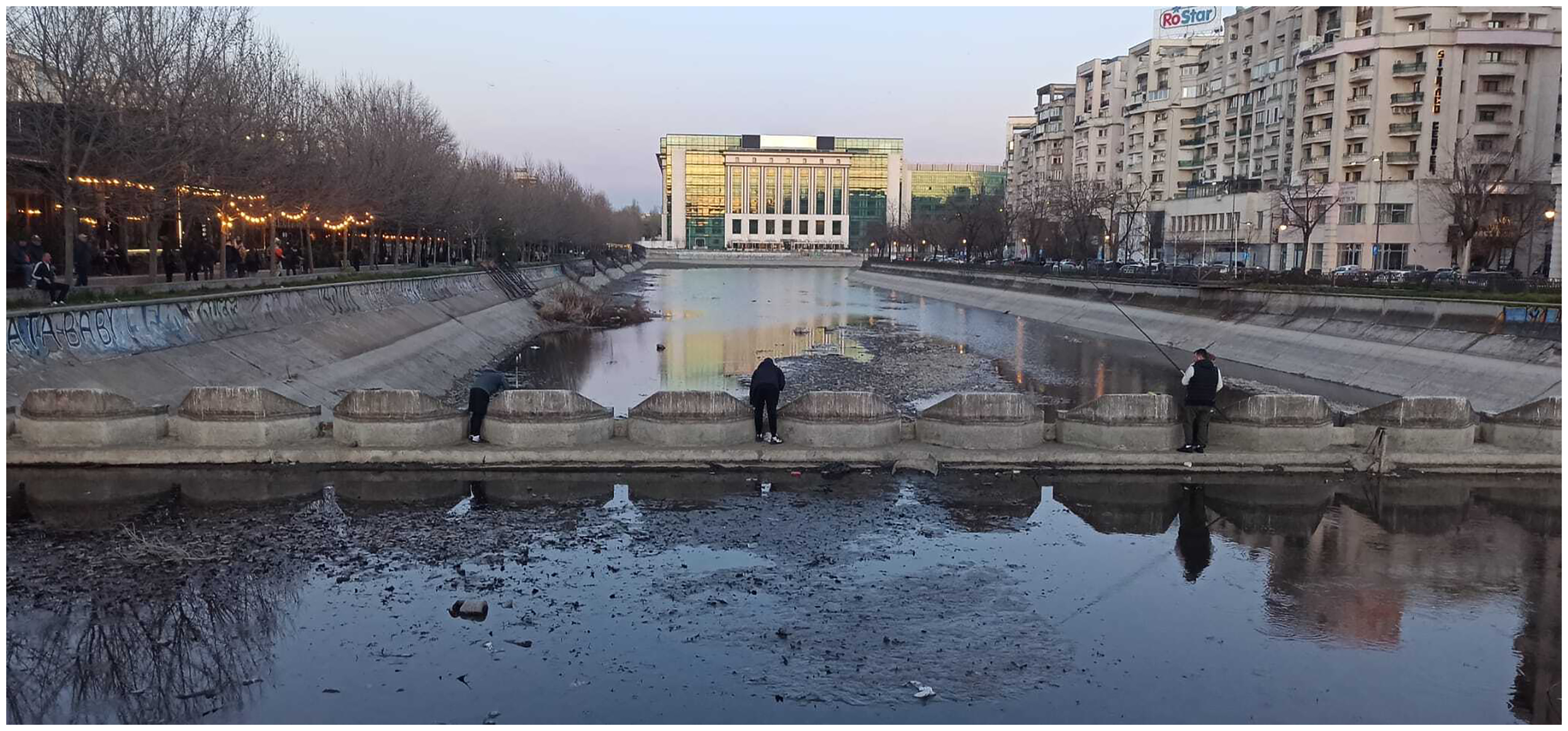
However, through this historical lens too the river seems to retain its duality—not enough and too much, life-giving and death-giving, modern but not quite, dead yet (potentially) alive, above- and underground, drinkable yet polluted. As the river has always been instrumental to debates about the city and shaped by the constructed legitimacies of the changing powers that be, we found the theoretical model of the ‘hydrosocial territory’ (Boelens et al., 2016), especially the role played by contested imaginaries (Hommes et al., 2022) in shaping the river, particularly useful. We have focused on the semantic mechanism that counterpoises the frame of the barren river to the one of the productive river, putting to work the various hydrological imaginaries available in different historical moments. It is not an ahistorical dichotomy, but a historically inflected mechanism that works by creating discontinuities, by making some connections more important than others, and by activating and articulating various fragments of the hydrosocial territory the river is part of.
There is, however, always something more, an elusive quality, as if the river manages to escape, only to be caught up again in these political-historical snares. The Dâmbovița has always been a permeable entity, a node within a dynamic system of ecological, social and infrastructural exchanges. Its leakiness is not a deficiency but rather a fundamental condition of its existence, just as Ingold (2012) and Ingold and Simonetti (2022) argue that all existing things are porous, they leak into and through the world. This paper adopts a larger political, ecological and relational historical perspective, where the river is a dynamic network, interacting with, transforming and mediating urban processes.
This is in line with contemporary efforts to conceptualize the river not merely as a problem (an obstacle to be controlled and overcome), but as an active element within the urban metabolism (Swyngedouw, 2006), a relational space where nature, technology and society intersect. From this point of view, everyday practices that contribute to fragile river commons—fishing, bathing, lingering by the river, or washing—help reframe the river, even if they are not coherent enough to be part of hydrological imaginaries. We do not suggest that such practices can resolve the river's historical-material fractures, or its environmental degradation, as they lack the institutional power to create the reformist space envisioned by ‘creative river’ environmental projects. Some of these activities, such as net fishing or washing carpets, even run counter to prevailing socio-cultural imaginaries of a ‘living river.’
Nevertheless, in addition to a deeper understanding of the river's historicity, these practices can provide much needed, if modest, hope that no creative or green-blue infrastructures can provide on their own (Kirksey et al., 2013). Drinking water directly from the Dâmbovița, as a powerful metonym for most of the postsocialist contemporary projects of ‘greening’ the river, indexes old fractures between the socialist ghost infrastructure and the future creative naturalness; but it cannot, at least for now, stop the river's ruination and ecological degradation. 12 Smelling fish on one's hands, if placed in a broader historical perspective, may serve as a tangible, sensory reminder of the political dimensions embedded in the existing socio-environmental order.
Footnotes
Highlights
We explore the natural, historical, political and social fractures that constitute the river. The aim of this article is to bridge the material and semiotic-discursive parts that compose the contemporary river. We follow the river in an ethnographical and historical way, both in its materiality and as a critical figuration Dâmbovița River is space of reform and innovation, but also unbridgeable material and discursive-rhetoric fractures.
Acknowledgments
Irina Zamfirescu helped us understand the complex administrative, urban and critical life of the river, Liviu Chelcea and Adrian Deoanca gave critical-imaginative insights into our text. The reviewers provided very important critical feed-back and we want to thank them. Teodor Frolu from the Ivan Patzaichin Association and Ina Dumitru from NodMakerspace were especially generous with their time and knowledge. We want to thank all the people who talked to us about the river and, last but not least, Dâmbovița itself.
Ethical approval and informed consent statements
Does not apply. All the interviewees have been anonymized and/or have consented for the use of the interviews
Funding
The Research Institute, University of Bucharest, ICUB 8404/26.07.2023.