
Abstract
This article analyses a range of diverse and often conflicting practices in and around a waterway in Accra, Ghana, emphasising the ambiguity of their politics. Urban political ecology approaches have demonstrated how flows of (waste)water reveal power dynamics across scales. I extend such insights by developing an understanding of practices that are more ambiguous, complexifying otherwise linear dynamics of power. I do this by centring the narratives of those living and working in the waterway. Through providing needed attention to the everyday and micro-level interactions, this approach makes room for situated ambiguities within wider power dynamics. The argument is based on qualitative research along one primary waterway in Accra, along which people live, farm, dump waste and manage flood risk. These diverse practices suggest that, in addition to distributing risks in an often uneven fashion, the waterway also affords connection, solidarity and adaptability across urban divides. I argue that accounting for these practices does not deny the inequalities of the waterway's geography; rather, it encourages the development of a vocabulary to understand situated processes, even where they appear ambiguous. Embracing the ambiguities of the waterway allows us to fully consider the complex forms that power takes in different settings.
Introduction
In June 2020, I was doing research in Accra on drainage and was concerned by a situation close to home. The apartment building I lived in had a stream running alongside it, and as we were in the midst of the rainy season, I would see from the fourth floor how the waterway quickly filled up and the waters picked up speed, carrying the accumulated garbage downstream. I often worried as the water levels rose, threatening to spill over its banks and reach the four kiosks 1 on the other side which housed two families and a group of young men. My concerns were not unfounded; heavy rains have been known to cause dangerous floods in Accra 2 (Amoako and Inkoom, 2018; Nyabor, 2018). I approached one of the people living there to ask about the rains, particularly because I could see young maize plants were growing on the banks of the waterway (approximately 20 m2 of ground) and I wondered if the intense rains and potential flooding were a concern for the urban farmer. The farmer was Baba, an older man who lived in the largest kiosk with his wife and children. He had moved to the area three years prior, from another plot of land a few hundred meters away that he called a slum, after a church bought the land and evicted everybody. Baba was from the north of Ghana, the Upper East Region. He had lived in Accra for a long time and went back to farm, and then he tired of farming and brought his family to Accra again in 2011. In the years I rented that apartment, the kiosks grew in number, in 2021 there were nine on the narrow piece of riparian land between the waterway and the wall of the neighbouring property.
Baba did not share my concerns; he had no problem with the rainy season. Apart from the slipperiness after rains, he was glad that the pressure of a heavy rain flushed away the trash in the waterway. Baba explained that two years earlier, before an election, a candidate for Member of Parliament paid to have the waterway desilted. The bottom of the channel was dug out and its contents dumped on the sides of the waterway. He used his pickaxe to remove all the garbage, mostly plastic, and burned it. Then he spread the soil out, very fertile from all the organic material, and then planted his corn and okra. He asked if I knew that the waterway was a stream, flowing from Aburi (the hills north of Accra), through here on its way to the sea. Baba shared that he was living on ‘no-man's land’, though he wondered if it was for the government. He speculated that the waterway would be covered and turned into a road, and until then he and the other people in the kiosks would be left in peace.
In the process of following this waterway, the Kordzor, along its tributaries down to the sea, I met many people living alongside it, farming alongside it, and dumping in it. I had many conversations about the potential dangers of the waterway and about its genesis as a stream or river. Where I saw the waterway initially as a site of risk and waste, backed by the literature as well as media discourse, the people living around the waterway introduced ambiguity to this interpretation. Baba's narrative draws attention to whether the waterway itself is a natural phenomenon or a human-made artefact: what is now known as a drain, or gutter, is actually a naturally occurring stream in the landscape. He also introduces an element of opportunity provided by the waterway, showing the affordances of the liminal space of the waterway for farming as well as housing. I take the ambiguity of Baba's narrative and of others in my research seriously. The variety of interactions people have with the Kordzor reveals different flows, not just that of wastewater. Where the Kordzor is for some people, on some occasions, a dumping ground and a sewer, it also serves as a source of irrigation and raw material for construction. These flows happening simultaneously trouble its designation as an infrastructure of waste and a site of risk and reveal interdependencies that complicate a unidimensional understanding of the waterway-as-drain or the waterway-as-river. A final and crucial ambiguity surrounding the gutter is the socio-spatial relations it affords. Many scholars have established that the socio-spatial configuration of infrastructures such as drains ‘cement’ inequality by distributing access to essential urban services unevenly (Anand, 2017; Swyngedouw, 2004). Many critical observers in Accra (Alba et al., 2022; Amoako and Boamah, 2015; Amoako and Inkoom, 2018) have shown this to be the case with regard to flood risk and access to water. The various ways that urban residents interact with the waterway do reflect inequality; however, this logic fails to recognise the entanglements and affordances described by Baba.
How might we understand an urbanisation of nature with ad hoc efforts at control, with varying levels of state involvement, with differing intentions and entangled outcomes? To answer these questions, I build on urban political ecology (henceforth UPE). UPE posits that ‘urbanization is a process of perpetual socio-ecological change’ (Kaika, 2005: 13), whereby nature is enrolled in a ‘metabolic exchange’ (Swyngedouw, 2006: 27). From this perspective, the Kordzor can be seen as a lens into the process of urbanisation: revealing the waterway as a landscape of metabolic flows. These flows move through (parts of) the city producing socio-spatial patterns, shaped by urban social and political realities, mediating, transforming and reproducing the city. The physical form that drainage takes is not divorced from the socio-political dynamics at play in Accra and vice versa. The political nature of such metabolic infrastructure means that the ways in which different stakeholders engage with the waterway can provide insight into power distributions. Approaching drainage from the UPE perspective, one comes to see how the waterway involves processes that are both ecological and social and that extend beyond the direct vicinity into other scales. However, where the field of UPE initially and justifiably focused on identifying and highlighting the deeply unequal dynamics of socio-natural metabolisms, recent critiques have urged a closer engagement with practices that support social reproduction (Doshi, 2017; Kimari and Parish, 2020). This facilitates a critical examination of structural inequalities towards forwarding alternatives that provide dignity (Baptista and Cirolia, 2022; Grossmann and Trubina, 2022).
Scholarship on heterogeneity and multidimensionality provides a useful counterpoint to the erstwhile linearity of UPE, stressing dynamism, redundancy and how disparate elements are brought together by different actors (Guma, 2022; Parnell and Robinson, 2012; Simone and Pieterse, 2017). Working from this sensibility, I argue that the ambiguity of the waterway's functions and meanings troubles tendencies to understand its politics as straightforwardly exclusionary or inclusionary (see also Narain and Singh, 2017). Following the entanglements of flows reveals various interdependent functions of the waterway. Higher-income urban residents also consume the vegetables from the Kordzor and build with its sand; both higher- and lower-income residents around the waterway protect and endanger each other through their measures against flooding. Such insights complexify our understanding of the power relations afforded by the waterway. Where others have seen transformation of nature as spurring separation and exacerbating inequality (Ajibade, 2017), the entanglements here also suggest connection and some forms of solidarity. Attending to ambiguities does not ignore the inequalities furthered by the urban metabolism, such as unequal environmental risks; rather, it tries to unearth a new vocabulary (Bhan, 2019) that is true to the experiences of urban residents in Accra but also inspires theoretical expansion elsewhere (Domínguez-Guzmán et al., 2022). With an eye to recognising both socio-ecological inequalities and the existence of urban political ecologies ‘otherwise’, I centre the experiences and narratives of those living and working in the liminal space of the waterway. The approach to ambiguity in this article provides needed attention to the everyday and micro-level interactions while making room for the situated within wider power dynamics.
The remainder of the article is as follows: first, I position the concept of ambiguity within UPE drawing on other bodies of critical urban scholarship. I then outline my case study and my methods, after which I continue with examples from the Kordzor, showing how the multiplicity of practices creates ambiguity. I end the article discussing what ambiguity might entail for our understanding of urban politics.
Urban metabolisms and ambiguous practices
This article is informed by and aims to contribute to scholarship within urban political ecology. Two of UPE's main tenets shape my approach to the waterway. First is the notion that ‘urbanization is a process of perpetual socio-ecological change’ (Kaika, 2005: 13) and second, that the translocal power dynamics that shape urbanisation produce unevenness. To provide brief illustrations, Wakefield’s (2020) study of the construction of oysters as a flood-resilience infrastructure in New York shows how nature is incorporated by capital. Her work points to the role of discourse in constructing the oyster as a ‘natural’ and effective solution to the risk of flooding. Ajibade (2017) shows how ‘resilience’ in the Lagos Eko Atlantic City project protects the financial interests of a transnational elite as well as prioritising higher-income areas over areas that are home to the urban poor. She emphasises that this must be understood as a socio-ecological process, whereby the flows of foreign capital and those of reclaimed sand from the ocean are intricately woven. Specific contributions within UPE on drainage make the point that both flooding and mitigation efforts reveal power dynamics across the local, national and global scales (Batubara et al., 2018; Henrique and Tschakert, 2019; Millington, 2021). In using a UPE lens, the authors show that drainage is a part of urban metabolisms, circulatory networks of ‘socio-ecological processes that are simultaneously human, physical, discursive, cultural, material, and organic’ (Heynen et al., 2006: 21).
In line with the aforementioned, I consider the process whereby the streams and rivers in the landscape are transformed into drains as part of the urban metabolic process (Gandy, 2004; Heynen et al., 2006). Within this process, I identify discursive and material efforts to discipline nature (Oliver, 2006; Robbins, 2012) through efforts to control its flows, making it amenable to continued expansion of the built environment. By extension, the expectation would be that drainage in Accra as a process (re)produces uneven urban development, whereby in the process of controlling the flow, the mechanisms that set up unequal access are strengthened, or the opportunities that the waterway provides to more vulnerable populations are restricted. Building on such insights on urban metabolism, this article contributes to the field of UPE by highlighting the role of ambiguity in such processes. To conceptualise ambiguity in the waterway and its political effects, I draw first on scholarship that addresses multiplicity in (urban) ecological formations and second, on work that engages with the practices of city residents in their pursuit of social reproduction, of ‘making-do’, practices that often evade easy categorisation but are usually dubbed informal.
First, I posit that ambiguity is reflected in the multiplicity of practices in the waterway: it is engaged with differently in different places and at different times. I borrow this idea from Hinchliffe and Whatmore (2006) who point out that a commitment to viewing urban ecology as a co-production of human and more-than-human entails a recognition of this ecology's multiplicity. Developed from Mol's ‘body multiple’ (2002), this approach sees the ontology of an object, and by extension its politics, as enacted through practices. Paying attention to (everyday) practices brings the multiple meanings of the waterway into focus. Kimari and Parish (2020), in looking at rivers in Nairobi and Toronto, depict variegated meanings through different practices, some of which are suppressed. In questioning what the river means, they unearth multiple, situated logics of urbanisation: of property relations, dispossession and resilience. These meanings do not stand in isolation. Through multiplicity, we can conceive of the city as relational parts in interaction (Connolly, 2019; Hinchliffe and Whatmore, 2006; Massey, 2005). This perspective facilitates tracing entanglements of people and things across the city (and beyond), recognising the connections forged by practices in the waterway. Tracing these entanglements and the interdependencies that they substantiate points to the diffuse nature of politics: ‘the need to understand power as operating not just through capital and class, but through other forms of identity, and enacted through a multitude of locations and agents’ (Lawhon et al., 2014: 509).
Second, in recognising the multiplicity of the waterway, we might also consider the process of urban transformation as incomplete, a term which Guma (2022) intentionally utilises not to mean deficient, but rather as in a process of becoming that is capable of responding to new demands. This calls attention to the constant and non-linear material changes in the waterway, unsettling a straightforward and final designation as drain. To question the linearity of urbanisation is not to minimise structural mechanisms at a larger scale. Rather, it is to argue that these structures are mediated by contextual, locally informed mechanisms. Thus, as Guma (2020) points out for smart technology in Nairobi and Cirolia et al. (2021) point out regarding sanitation infrastructure in Addis Ababa, the non-linear progression of technologies of service delivery can be understood as shaped by dynamics at multiple scales. Their approach sees these interactions as a significant part of the urbanisation process, meaning that even within entrenched global power structures, urbanites are also able to shape their own livelihoods and urban environments. As Vasudevan asserts of his conceptualisation of makeshift urbanism: it speaks to the unjust structures of dispossession, exclusion and violence that define and shape the experiences of many of the world's urban dwellers. On the other hand, it also points to the possibilities – complex, makeshift and experimental – for extending, improving and sustaining life in settings of pervasive marginality. (2015: 354)
This entails an appreciation of the relations, tactics, materials and narratives that are assembled to make city life liveable.
Both multiplicity and incompleteness contribute to a conceptual model that allows a recognition of ambiguity across the waterway, one that centres the divergent meanings and the versatility of the waterway. This has impact on how the politics of socio-ecological processes are understood. Multiplicity reveals entanglement and interdependence, for example, as residents across the city consume crops irrigated by the Kordzor. Incompleteness reveals continuous change, for example, when drain culverts are constructed and then degrade. Accordingly, I take everyday practices as an entry-point to understand the politics of the waterway, recognising the intended and unintended impacts of these practices, and the non-linear changes associated with them. Ambiguity allows me to parse situated power dynamics in the process of the Kordzor's urbanisation while simultaneously foregrounding urban politics as involving lived experiences and constant negotiation.
Case and methods
Accra is situated on the coast with hills framing the city to the north. Within the Greater Accra Metropolitan Area, there are 12 drainage micro-basins, varying in size. Each basin has a primary waterway and often multiple tributaries. The city of approximately 4.9 million people is dependent on these primary waterways to channel its runoff. Over time, and with urbanisation, these waterways have seen intervention to channel their flow and perhaps indicative of this transformation the waterways are often called drains, or in colloquial terms, gutters. The empirical evidence presented in this article is drawn from my observations, interviews and conversations with residents and other regulars along the Kordzor primary waterway. The Kordzor is about 13.2 km long and in a constant state of construction and maintenance. While government officials think its entire length will be lined with concrete in the future (interview, Ministry of Works and Housing, 2020), concrete currently only lines intermittent sections: around culverts, in places where erosion threatens and where flooding has previously caused damage. In some of these cases, the concrete has been laid by urban residents themselves. There are, however, many other forms of intervention in the waterway: raised banks, sandbags and footbridges of varying permanence.
In mid-2020 and early 2021, I set out to document the numerous ways in which urban residents relate to the waterway. I began my research upstream and worked my way downstream towards the coast, sometimes with a translator (for Twi and Ga). Inspired by work within UPE which looks at connections and tracing (Gandy, 2014), this approach centres the waterway as the locus of a multiplicity of practices (Kimari, 2021; Kimari and Parish, 2020). By following the practices through time and space as they link places across a section of the city, I attempt to make visible how these practices flow and create entanglements beyond the waterway, beyond the basin. This aligns with UPE's mandate to ‘follow actions and, in doing so, explicate the relevance of our findings to different, though related, sites’ (Connolly, 2019: 73), albeit on a smaller scale. The approach also allowed me to meet the distinct and varied relationships to the waterway, cutting across different groups of residents. I also frequented locations along a neighbouring basin, the Odaw, to compare. In the course of my follow-the-waterway method, I met and spoke with urban residents living along the waterway in different forms of housing, and I met with salespeople trading a variety of food and other goods, real estate developers, caretakers of buildings in different stages of completion, security guards and construction workers. I also spoke with government officials at the local municipal level (the Kordzor crosses four assemblies 3 ) and at the national level (Ministry of Works and Housing; National Disaster Management Organization) as well as drainage engineers working on a drainage master plan for the metropolitan area for contextual information on the waterway and its transformation. Interlocuters generally found it self-evident that I was interested in the waterway as flooding was a major recurring issue in the city.
Throughout my fieldwork, I encountered what I have come to frame as ambiguity. My analysis relies primarily on my interviews, informal conversations and observations along the Kordzor. In my encounters, I asked about perceptions of the waterway, practices related to the waterway and stories of change over time. I paid attention to the practices along the way, asking questions about the different ways people engaged with the Kordzor. I asked where flows went to and who was involved. The levels of clarity here varied, interlocuters often could identify one or two exchanges beyond themselves. For example, with regard to sand that was collected and sold, I was told it went to a construction site but no further details. The focus here was not on the veracity of their narratives, but on their experiences and common themes. The dimensions of ambiguity gained shape through the varied and often contradictory narratives and practices of my interlocuters. Multiplicity was evident through the juxtaposition of practices that I and interlocuters found incongruent, while change and non-linearity emerged through the stories of interlocuters as they reflected on changes in the waterway. I have taken care to categorise the practices based on locally informed meanings. This is in part possible because I am familiar with Accra, having lived there for most of my life and because I discussed the different meanings of the waterway with interlocuters as well who often expressed surprise or bewilderment at some of the practices I described (particularly practices that emphasise the Kordzor as food source).
As can be seen in the map (Figure 1), the Kordzor flows in a general north to south direction. In following it, I passed through a variety of neighbourhoods which I shall list here in an order which approximates that of the flow. I started in Mempeasem that falls on the boundary between Madina and East Legon. An old village annexed by urban sprawl, Mempeasem today is a mix of traditional compound houses, large single-family houses, apartments and hostels housing students of the nearby University of Professional Studies and informal homes (mostly kiosks). The Kordzor then continues through mostly up-market East Legon and Adjiringanor, the industrial area of Spintex, and alongside the gated communities of Regimanuel Gray and Manet in East Airport. Across the waterway from the gated estates lie the old village of Martey Tsuru, another old village with a similar housing composition to Mempeasem. Next, the Kordzor flows through Agbleze, Teshie and Tse Addo. The former two are mixed-use areas, both older neighbourhoods. Tse Addo is recently privatised land with up-market homes and apartment buildings as well as compound houses and informal living structures. Finally, the Kordzor flows into a lagoon in Kpeshie and enters the sea on the east side of the Labadi Beach luxury hotel.
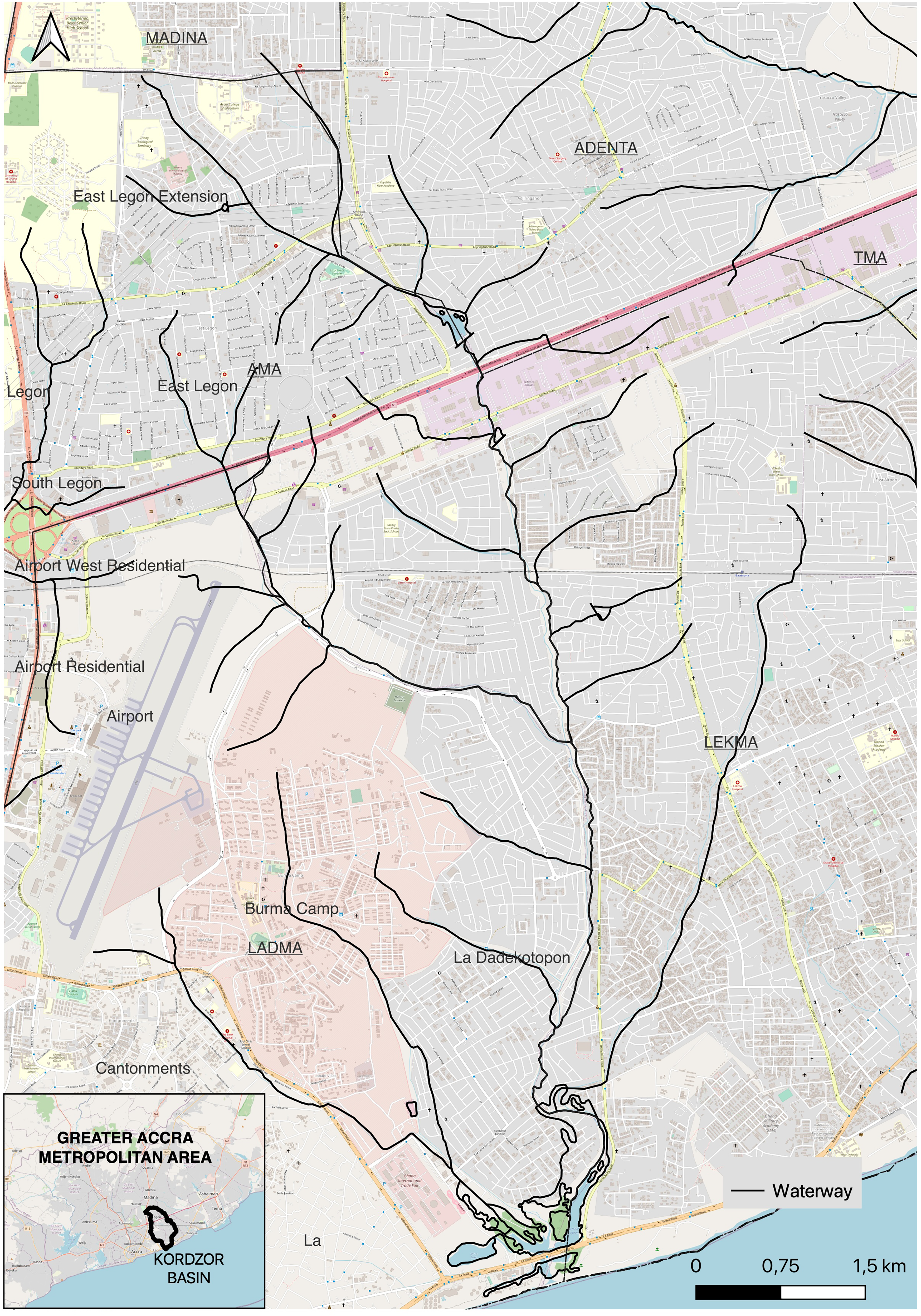
Map of Kordzor waterway.
Ambiguity in the waterway
In the following section I present a selection of stories and encounters along the Kordzor that highlight ambiguity. First, I present practices that emphasise the Kordzor as a river – as a source of water, fish, sand, flows of surface runoff and bucolic views – and juxtapose these with practices that emphasise the Kordzor as a waste channel. This analysis highlights that these practices occur simultaneously, some in tension and some in tandem. Second, I discuss the waterway as an incomplete space that affords a range of practices that people may want to keep hidden. This too is ambiguous as it often remains unclear what is happening in the waterway, in part because lines of responsibility, ownership and accountability are unsettled.
Finally, building on these discussions, I explore what ambiguity means for the politics of the waterway, discussing how interdependence and unevenness show up in the waterway as seen through these encounters.
Entangled practices along the Kordzor
As Baba's garden introduced, farming alongside the Kordzor provides affordances such as access to water for irrigation. There were others for whom the water source enabled growing and selling decorative plants. Small gardens like Baba's or larger pieces of land for urban farming were visible in sections of the waterway which were not completely built up, mostly upstream and midstream. One such farm had irrigation pipes leading away from the waterway, indicating the use of a pump (Figure 2). Only 50 m away, a water truck stood idle, pumping water from the Kordzor into the large tank labelled ‘river water’.
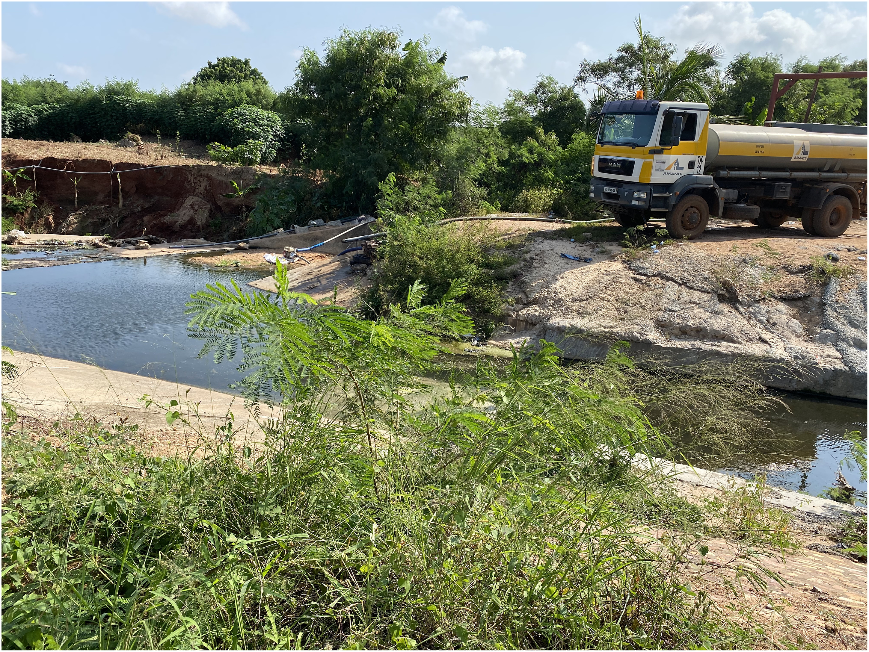
Midstream flow pumped into farm on left and water tanker on right.
I also encountered one fisherman, a man who woke up every day before dawn to try his luck on a section of the Kordzor that formed a large pond, about midstream. He fried and sold his catch to his neighbours in an auto constructed settlement. On occasion he caught catfish. It was a measly catch the day I met him; he showed me the bowl with about eight pieces of fried fish (Figure 3). While he offered me some to taste, I declined as I was hyper-aware of how the pond and the tributaries that flowed into it were used as channels for all types of waste.
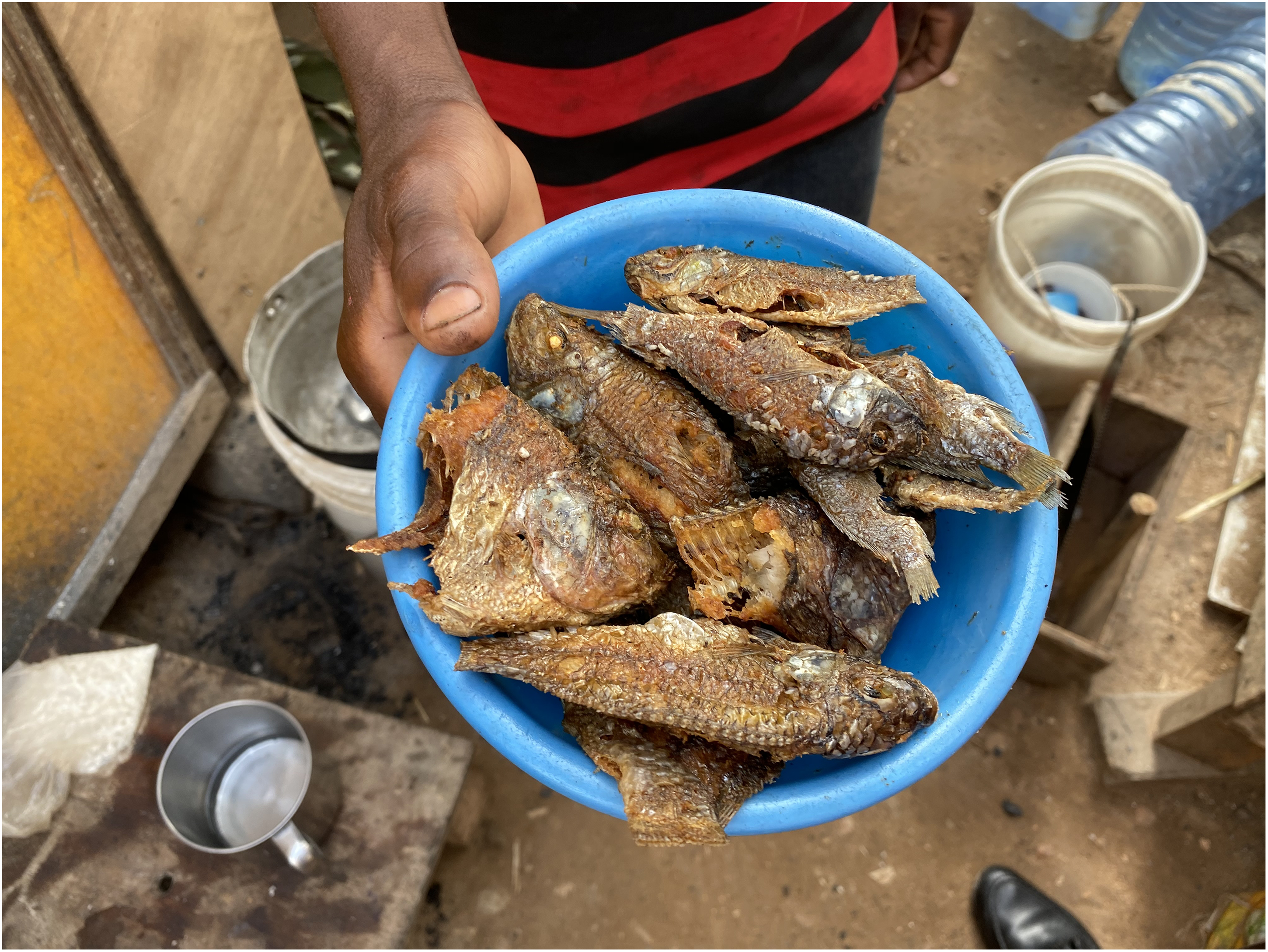
Catch of the day, upstream near Adjiringanor.
Mid- and downstream, where the Kordzor widens and flattens out, I spotted a lot of sand mining. Fine sediment from sandbars in the waterway were dug out and packed into sacks for sale. As a mason in Tse Addo explained to me, fine sand was especially good for plastering walls. He said this as he was making trips to and from the waterway with a metal basin to collect the sand. We were about 3 km from the sea and water levels were relatively low, so many sand banks were visible. Earlier, in Agbleze, a woman told me about ‘area boys’ digging up sand from the waterway and bagging it in her compound. They were digging into the ground so she asked them to stop and then they moved down to the waterway itself. For her the Kordzor brought danger; the edges of the compound she was renting had eroded over the years. She said that if she had known this would be the case, she would not have moved here, and as a result, she was seriously contemplating leaving at the end of her lease. Sand mining (called sand winning in Ghana) reflects the increased demand for concrete and cement houses in Accra (Danso-Wiredu and Poku, 2020; Yeboah, 2016), as well as high levels of unemployment (Dawson, 2021), even small scale and unregulated riverine sand mining such as what I encountered.
Practices in the waterway respond to changes in flow, such as flooding. For example, in Tse Addo, a chop bar eatery did not operate when the water levels rose. The proprietor told me she would not bother coming in when there were heavy rains. In Alajo, on the Odaw River, inhabitants of a compound house detailed how they organised their possessions in their rooms during rainy season to safeguard them in case of a flood before going to work. This was in addition to the physical alterations they had made to their homes, constructing higher thresholds of cement to the compound and their separate quarters.
While many residents turned away from the Kordzor, constructing barriers and walls, one real-estate developer described to me his plan to make it an attraction. The luxury apartment complex he was developing was named Riviera Residences, and he was lobbying local government to have the large pond renamed the Riviera. With plans for a waterside promenade and a fountain, the developer's ideas saw the Kordzor as a resource, one that would complement high rents charged in US dollars.
Multiplicity is also found in the tension between some of these practices, most obviously noted in the use of the waterway as waste channel and source of food. Upstream in Mempeasem, about 12 km from the sea, the waterway was narrow and shallow. It was littered with trash, most of it plastic bottles and Styrofoam food packets, perhaps because of the student hostels in the neighbourhood. As Baba had pointed out, rainfall promised quicker flow and up and down the Kordzor. I was told that dumping garbage was particularly efficient during or after a big rain, though it was also done at other times.
Along the entire Kordzor, I saw pipes. As they visibly jutted into the waterway and its tributaries, they served as a reminder of one of its functions: as a channel of wastewater. Grey water is the term given to household wastewater (from kitchens and bathrooms). While it is illegal to use the waterway as sewerage, grey water may flow into the city's waterways alongside surface runoff. 4 Following the Kordzor, I came across many indications that one of its many functions was that of a sewage channel. In East Legon, at least one house had set up their sewerage to flow into the drain. Once, I startled a man relieving himself in a quiet corner of upscale East Legon, embarrassing us both. Less than 20 m away was an urban farm, watered from the same place. Beyond my scatological panic, these encounters were a reminder of the dearth of sanitation options for mostly low-income residents of Accra (Songsore, 2008).
These examples show the multiplicity of the Kordzor, its function as a resource for sustenance, for maintaining livelihoods and a storm drain. This was reflected in the practices I documented along the waterway, but also explicitly in the narratives of actors as they invoked the source of the Kordzor in the mountains or unsettled its designation as drain by highlighting it as a resource. By emphasising the ambiguity here between risk and resource, I do not downplay the unevenness in the waterway. Besides the real-estate developer, it was mostly low-income residents turning to the waterway as a resource. The value of ambiguity here is to challenge the assumptions around the waterway as solely a channel of waste and flood risk by recognising how it plays a role in the social reproduction of people living around the waterway (Doshi, 2017). Ignoring these practices may reproduce limited notions around what is considered material or of import to the process of urbanisation. Next, section I discusses the space of the waterway, how it serves as an incomplete and in-between site for practices that are often hidden and that reflect continuous change.
No-man's land 5
The waterway is an incomplete space, sometimes referred to by my interlocuters as ‘no-man's land’, occasionally a space used by low-income migrants from outside of Accra to make an informal (first) home in the city. During fieldwork in 2020, I met Frimpong in East Legon. He was living in a small community of shacks built on both sides of the waterway, with the high walls of large houses forming their outer limit. He had moved to Accra a year before and had found a job in East Legon. The presence of the shacks had surprised me; they were very well hidden and completely invisible from any road. To reach the first one, I walked 20 m through a dense growth of banana trees – perhaps the first indication that people lived there. Frimpong said that the inhabitants of the mansions around knew that they were there; on occasion they were told off when they were too loud. He was the newest member of this small community; others had been living there for years. When I went back in early 2022, all the shacks had been removed; only the construction rubble they had used to fill up the banks remained.
For others the space was an opportunity to use the seclusion (and flow) as a site for sanitation needs or for doing things they would rather keep hidden. Walking alongside sections of the waterway where the bush was thick was an exercise in dodging faecal matter and trash (Figure 4). In Labadi, I encountered two children holding hands and singing on their way to the waterway; they told me when asked that they were going to use the ‘gutter’ for toilet. On that same day, slightly more upstream in Tse Addo, I saw three men sitting on a bench in the bush smoking marijuana. As most buildings were aligned away from the waterway, a reflection of its function as waste channel, the banks of the waterway were often secluded, sometimes covered in vegetation. This feature made the no-man's land suitable for doing things in secret.
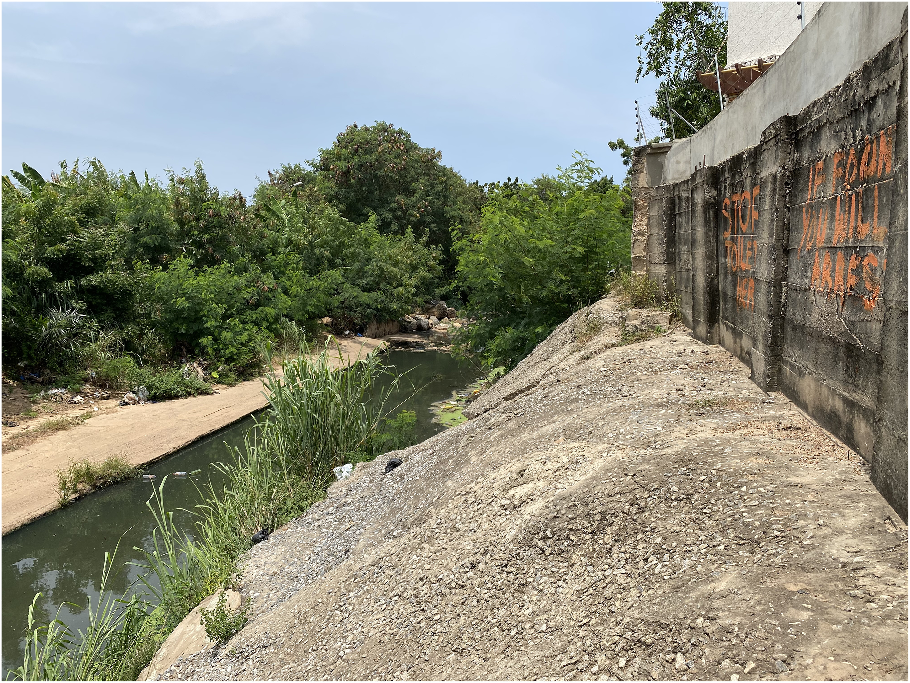
Text on the wall reads: STOP TOILET HERE. IF FOUND YOU WILL BE ARRESTED. Near Martey Tsuru.
The incompleteness of the Kordzor means that it is constantly changing. As described before, it is not completely channelised and even then, some interventions change shape over time, wearing down (Figure 5) or undergoing constant maintenance. The bed of the waterway itself is dredged up frequently in different places and at different times. The (potential) volume of the Kordzor is not always the same, shifting with the seasons and shifting as sand is dug up and flows back in. Unsurprisingly, the banks of the waterway were the landing ground of concrete and other building materials in service of flood and erosion prevention. However, there were also other building materials that came from construction sites across the city. Upstream in Mempeasem, I spoke with a woman named Ama who described her community's flood prevention strategies. She and her neighbours lived in kiosks on a piece of land which had not been claimed by a landowner. To limit overflow from the stream only a few meters before them, they used plaster bags one neighbour brought from the construction site he worked on. These nylon bags were filled with sand from the waterway and then laid in a brick-like fashion. The Kordzor was also often and temporarily home to excavators and diggers that were sent by a variety of institutions 6 or rented by wealthier homeowners to dig up the sand and increase the volume of the waterway. These examples of labour and technologies in the Kordzor emphasised that some socio-material practices were geared towards risk management, such as these small-scale interventions that could be referred to as instances of heterogeneous infrastructure configurations (Lawhon et al., 2018; Smiley, 2020). They also represent the continuous work of repair and maintenance to keep overflow at bay, and in the process connecting disparate places through stuff, such as the bags from a construction site or the rented excavators.
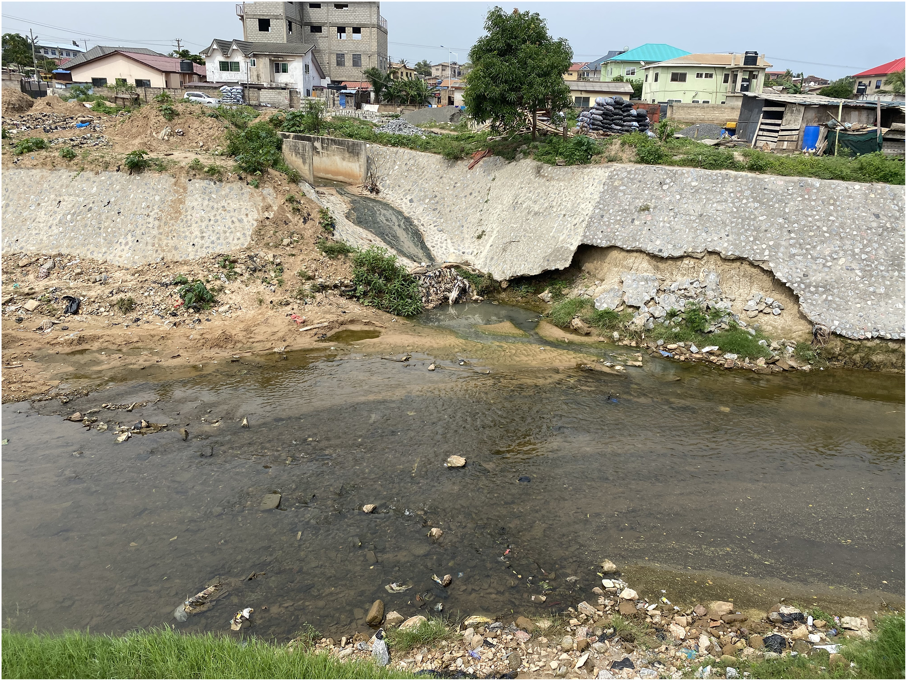
Lined section near bridge in Tse Addo.
Midstream was the first place I saw fish in the water. It was a small school of silvery fish in the shallows, a reminder of the waterway being a home to more than humans. Afterwards, I spotted fish on more occasions, though as one interlocuter told me, it was nothing compared to what it had been. Kofi, a young man, lived above a bar in Tse Addo and he spoke passionately about the animals he had seen along the Kordzor. As we looked over the water, he named alligators, mud fish, one man thousand (very small fish), pythons, cobras and rabbits. He described a black bird that would come every morning to wash and afterwards dry itself on a tree. He felt the area was a jungle; we should not be there. Turning to his friend behind us, he said: ‘you think it is a gutter, but it is a river’. His attempt to inform and perhaps shift his friend's perspective mirrored how Baba had shifted mine. Separately, I was told in a similarly revelatory fashion that the pond in Adjiringanor is said to have been a cattle watering hole when nomadic herding was more common and before people encroached on it with their buildings. Kofi's story shows the perceptions of changes over time particularly by those living along the waterway. The waterway and its banks are constantly changing, in material composition, in housing stock and population of humans and non-humans. These changes were framed by a few interlocuters in terms of a transition from river into ‘gutter’.
The ambiguous no-man's land can be viewed as suffering from neglect, and at the same time, the ambiguity allows many things to happen (Anand, 2023). This riparian space is used surreptitiously for housing and hidden activities and sometimes claimed openly and without reservation. The aforementioned examples show that change is continuous and that this continuous transformation supports and is reflected in the varied uses of the waterway by different groups.
Politics of ambiguity
In my descriptions of socio-material practices, I have tried to illustrate the entanglements and continuous non-linear transformation in the waterway. Altogether, I have dubbed these ‘ambiguous’. In trying to understand a process of urbanisation of nature which is ambiguous, it serves to consider that the socio-political outcomes may match. Which is to say that while the capacity to deal with overflow is indicative of power distributions, the entanglements and non-linear transformation described above complicate our understanding of said distributions.
First, I reiterate that the low-income people who live along the waterway and make their living off it are most at risk of the dangers of flooding, as well as less able to absorb the effects of flooding such as loss of homes. There are also the poor health outcomes related to social reproduction in the waterway. These are inequalities that are exacerbated by their proximity to the Kordzor. It is important to ground the dynamics above in structural logics in the city and beyond. What happens in the waterway, and the so-called no-man's land that borders it, might appear to be unique to these spaces, but serves as a reflection of wider processes (Kamath and Tiwari, 2022). The processes that marginalise urban residents who often turn to the waterway for their social reproduction are constitutive of Accra's urbanisation. Lack of affordable housing (Gillespie, 2020) and affordable land (Owusu, 2008), rural–urban migration (UN Habitat, 2015), unequal access to waste management (Oteng-Ababio et al., 2013), World Bank-funded infrastructure projects: these and other processes contribute to the dynamics of practices and power relations in the waterway.
It is not only Accra's most vulnerable living in the waterway; there is a diversity of housing forms that do not uphold the 5-meter buffer to the waterway mandated in the Drainage Master Plan for the Greater Accra Metropolitan Area. Drainage experts point to this as one main reason for flooding damages (Amoako and Inkoom, 2018). Housing forms ‘encroached’ (in the parlance of government officials and the media) on the waterway using construction rubble to fill up and reclaim the land and to serve as a flood barrier. The high demand for housing and land in Accra had multiple manifestations along the Kordzor. In one case in Adjiringanor, I was told that the buffer had been claimed by two different property owners who were then embroiled in a dispute over it. Due to the intricacies of the land tenure system (Tieleman and Uitermark, 2019; Yankson and Gough, 2000), the high demand for land in Accra, the housing laws (Grant, 2009) and the electoral danger that demolitions could pose to politicians (Nathan, 2019), larger communities in the waterway and large mansions may avoid or survive demolition drives. In addition, some property owners may have obtained building permits from their local assemblies, making their removal difficult (interview at Ministry of Works and Housing, 2020).
Multiple levels of governance also contribute to ambiguity (see also Poku-Boansi et al., 2020). While primary drain construction is the mandate of the Ministry of Works and Housing, maintenance of drains and culverts falls to the assemblies (district, municipal or metropolitan). In addition, other state institutions play a role in the construction and management of drains as well as related activities such as emergency action during and after flooding, public information provision and waste management. Drainage engineers therefore favour drain management at the scale of the basin, to address overlapping administration as well as the unique needs of each primary drain.
While I have described a diversity of actors and stakeholders (even more-than-human), I must consider where this multiplicity is acknowledged and where it is not. For example, the state may highlight the use of the waterway for garbage disposal to place the blame for flooding on residents and avoid accountability. Within this multiplicity, some practices are enabled and supported, while others are actively suppressed by the state and elites. This is why some must hide. The interventions to control the drain such as channelisation represent a project that is on occasion thwarted by the practices that emphasise its riverness. But these projects are not of equal power. The socio-material practices that emphasise the Kordzor as river are in tension with the project of Kordzor as drain. The project of Kordzor as drain is bolstered by an imaginary of it as a waste channel, not in the least by its ubiquitous label as gutter. It is against this imaginary that fishing and farming appear incongruous, and practitioners narrate how the waterway was once home to a variety of wildlife or emphasise that it is a river by invoking its source in Aburi. This is where the unevenness lies, leading to exclusion and exacerbation of precarity.
That said, my contribution here is to engage with the practices that, while small in the face of extended urbanisation, show interdependence and (intentional or not) mutual support. As some interlocuters have pointed out by evoking its origins in the hills, the Kordzor itself creates connection. In addition, the disparate materials entering and leaving the waterway at different moments and places reveal connections to places far and near to the Kordzor itself. People and things are brought into connection and entangled with each other: the fish in the bellies of the fisherman's neighbours, perhaps later expelled back into the pond, the garden plants bought by the roadside watered by the Kordzor, the water trucked away in the ‘river’ tanker and the sand used to plaster houses close by and far away. The flows from the waterway reveal that materials from it or fed by it are consumed elsewhere in the city. The practices along the Kordzor are also in relation to each other. Baba's farm, small as it is, stands in relation to the electoral politics that dredged the waterway where he lives. Urban farms like his also serve to retain surface water, mitigating the effects of runoff such as flooding. As Ojani (2023) notes, infrastructuralisation often produces unforeseen affordances that are contingent on the materiality of its parts. This is evident, for example, for farming: the soil is fertile because of the waterway's use as a waste channel. This is the relation of power that ambiguity captures, the cracks in the structural logics thereby suggesting that interdependence and unevenness coexist.
Conclusion
Urban political ecology asserts that processes of urbanisation must be understood as embodiment of metabolisms, the resulting socio-spatial formations neither urban nor rural but decidedly uneven. It is from this starting point that I understood the divergent practices I encountered in the Kordzor waterway in Accra. However, the narratives of people living and working alongside the Kordzor introduced an ambiguity that is not exhaustively explained by urban metabolism. While the Kordzor appears initially as one entity in the process of being turned into infrastructure, the multiplicity of practices reveals multiple meanings. In this article, I have explored a new vocabulary, ambiguity produced by multiplicity and incompleteness, to discuss the practices in the waterway which takes my interlocuters’ narratives and concerns seriously. With this vocabulary as a tool, I aim to understand the multiple practices and entangled outcomes around the waterway. These suggest interdependence, alongside unevenness.
Ambiguity provides an answer to the question of how to grasp contradictory and disparate practices within the process of urbanisation. The multiplicity of practices that interchangeably emphasise the Kordzor as river or Kordzor as drain is continuously changing. Paying attention to these context-dependent mechanisms that often play out on the micro-scale enables discerning and tracing the practices in and out of the waterway. Herein lies my modest contribution to the literature, in extending the ambiguity of the waterway into its politics, evidenced by the interdependence and continuous transformation of the practices in the waterway. Here I join Cornea et al. (2016) in presenting a politics of water that is situated and nuanced. As waste waterscapes expand analyses of urban metabolism (Karpouzoglou and Zimmer, 2016), the Kordzor as more than waste channel elucidates that there are interdependent practices that animate the urban environment – even when they are seemingly in tension. This further informs analysis of Accra's and other cities’ metabolisms as encompassing a variety of socio-ecological relationships, some of which make use of waste flows to sustain livelihoods.
Ambiguity is especially salient in urban contexts where residents make do with resources that are at their disposal, where ‘materials and places are put to use for functions for which they were not intended’ (Simone and Pieterse, 2017: 16). The presence of tires and construction rubble, for example, in the waterway may contribute to a sense that there is a lack of clarity, a pessimistic interpretation of the word ambiguity. However, in this article, ambiguity lends an impulse to politics in the form of an alternative imaginary of the infrastructure. In its multiplicity, and the potential for change in a non-linear direction, the waterway provides affordances to urban residents – often those at the margins. While I do not intend to romanticise their livelihoods or precarious living situations, I take their practices and narratives seriously and suggest that scholarship might further engage with these cracks in the logic of urban metabolisms.
The choice to engage with practices at the scale of the Kordzor rests on the thought that that this scale is not less important than any other. This is in furtherance of the project that pays attention to micropolitics and embodiment (Doshi, 2017; Truelove, 2011), as well as to the politics of contexts outside Euro-America (Lawhon et al., 2014). While the analysis here draws on situated examples specific to Accra, viewing urban metabolic processes through the lens of ambiguity holds implications for socio-natures elsewhere. Tracing the flows that these practices are entangled in has the potential to illuminate processes of extended urbanisation (Kaika et al., 2023). Take, for example, Baba's story at the outset of this article. His home alongside the Kordzor is connected to processes that make farming less viable in northern areas of Ghana, as well as electoral practices. It is in taking his experience seriously that these entanglements are made visible.
Highlights
A range of diverse and often conflicting practices in and around a waterway in Accra emphasise ambiguous politics.
These practices suggest, in addition to an uneven distribution of risks, the waterway also affords connection, solidarity and adaptability across urban divides.
Embracing the ambiguities of the waterway allows us to fully consider the complex forms that power takes in different settings.
Footnotes
Funding
The author disclosed receipt of the following financial support for the research, authorship, and/or publication of this article. This work was supported by the Nederlandse Organisatie voor Wetenschappelijk Onderzoek (grant number 452-17-003).