
Abstract
Wasteland governmentality has long shaped colonial and postcolonial landscape governance across the planet. While historically wasteland classification was deployed for agrarian land settlement and silviculture, with extended urbanisation it is increasingly used to consolidate landscapes of extended urban nature. These landscapes are in turn subjected to state-led land enclosures for urban and infrastructure development and for greenwashing. This paper investigates the political construction of one such landscape of extended urban nature, the Aravalli region, a geological feature which runs parallel to the extended corridor urbanisation in the Delhi National Capital Region (NCR). Particularly, I examine how in the name of regulating mining, urban development, and pollution in the Delhi NCR, the revenue wastes including sacred groves, hills, and other village commons falling in the Aravallis have been consolidated as a state space. I examine how the patchwork of communities assembled in the extended urban fabric of the region deploys the sacred to counter land enclosure and the emptying out of meaning. I discuss three such modalities of the sacred in the region, namely, its use by agrarian villages to assert land rights over sacred forests, the misuse of the sacred by temple committees to produce faux nature, and its use by emergent urban environmental movements in the region to frame an anti-wasteland politics. Focusing my attention on the state, I discuss the need for a nuanced understanding of emergent urban environmentalism in the region as restorative commoning beyond the binary framings of bourgeois versus the poor.
Introduction
The extended urban region of Delhi is demographically the largest and the most extensive urban conurbations in the world second only to Tokyo (PTI, 2014). As I have written elsewhere (2021, 2022), this urban conurbation or the ‘extended city’ is a result of multiple intersecting processes of extended urbanisation such as the constant expansion of the regional boundaries of the Delhi National Capital Region (NCR), and projects of state-led urban-economic corridors such as the Delhi Mumbai Industrial Corridor (DMIC) and others planned as part of the Bharatmala highways programme. Delhi's urban conurbation extends southwards into the fertile agrarian belt running parallel to the Aravalli mountain range also commonly referred to as the Aravallis (see - Figure 1); a roughly 700-kilometre-long geological feature that emerges from under the alluvium deposits just beyond the city of Delhi and runs in the south-west direction until the state of Gujarat (Valdiya, 2015: 128). The Aravallis are considered to be one of the oldest land formations on earth, formed through the metamorphosis of sedimentary rock into quartzite stone over two billion years ago (Lal, 2017). Due to its rugged rocky terrain and steep topography, the Aravallis could not be cleared under the colonial wasteland settlement programmes for agricultural settlement and expansion in the region. Its hills were thus consequently classified as revenue ‘waste’ colloquially referred to as gair mumkin pahar (uncultivable hills) that were treated as a deemed commons by agricultural villages in the region. An unintentional consequence of this has been that the Aravallis survived as the only contiguous forest and wildlife corridor in the extended urban conurbation of Delhi, which has opened it to a range of projections and contestations over urban nature.
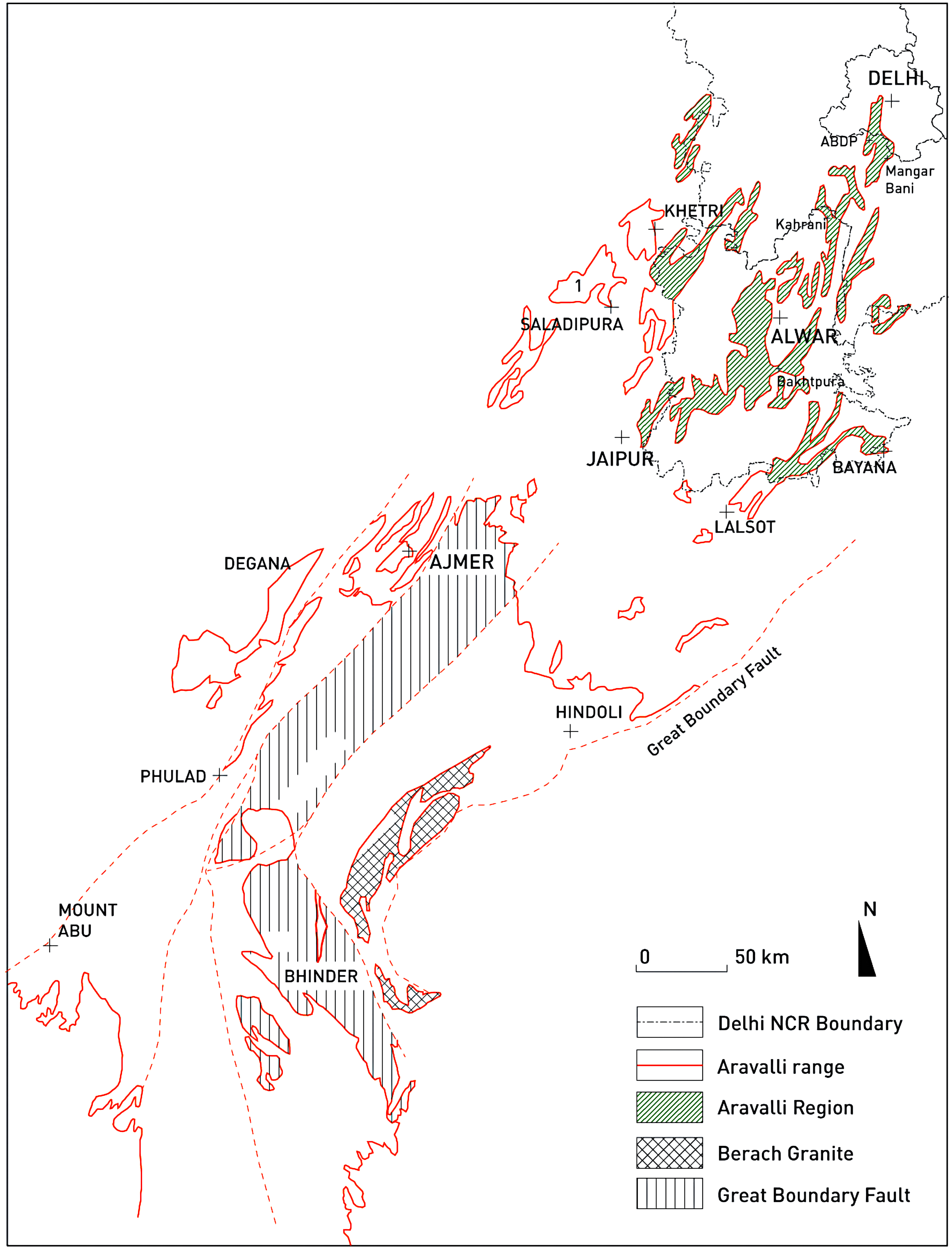
A simplified geological map of the Aravalli Range based on ‘The making of India: Geodynamic evolution’, K.S. Valdiya, 2015, p. 138.
Recent scholarly explorations by Amita Baviskar (2019) and Thomas Crowley (2020) on the Delhi Ridge, the section of the Aravallis falling within the city of Delhi have analysed how mining, elite enclosures, and the politics of waste have operated through the intensification of a nature-culture divide in postcolonial Delhi. While the Delhi Ridge is a contested space of urban nature where the state is making renewed attempts to extract forms of capitalist value and evict working-class communities through enacting ‘aesthetic governmentality’ (Ghertner, 2015), the contestations in the Aravallis in the extended urban region of Delhi has not received critical attention barring fragments in the works of Amita Baviskar and Shubra Gururani (2019). This space of extended urban nature (Desfor and Keil, 2004), which has been politically constructed as the Aravalli Region much like the Delhi Ridge, is significantly shaped by ‘wasteland governmentality’ (Baka, 2013) through which the state attempts to extract new forms of value and legitimise enclosure.
Drawing upon ethnographic fieldwork conducted in the extended urban region of Delhi between 2018 and 2020, I attempt to analyse how the Aravalli region has been assembled and constructed as a regulatory space of extended urban nature accompanying the ongoing extensive urbanisation around Delhi. I describe the cyclical ways in which wasteland classification and arboreal biopolitics (Davis and Robbins, 2018) has been mobilised to diminish the ecological significance of the Aravallis and subject it to new forms of enclosures and value-seeking processes. Further, I examine how the paradigm of the sacred drawn from the presence of ‘sacred groves’ in the region is being variously deployed by communities in the region to counter land enclosure and the emptying out of meaning. I then analyse emergent counter-movements of urban environmentalism in the region that are attempting to invent an anti-wasteland politics and reinterpret the sacred and native planting traditions through what I describe as restorative commoning.
Following a survey on wasteland classification and wasteland governmentality in the next section, I attempt an analysis of regulatory frameworks that have been projected on the Aravallis in the extended urban region of Delhi. I then analyse some past and ongoing wasteland development programmes, followed by a historical analysis of accounts on the sacred ecology in the region. As part of the mobile ethnographic research, I conducted participant observation at protest sites, rewilding projects, and sacred forests in the Northern Aravalli region. I carried out semi-structured interviews with activists, inhabitants, environmentalists, and government officials. Additionally, I analysed archival documents, public interest litigations and reports. I discuss these in the final section of the paper.
Wasteland and wasteland governmentality
Wasteland classification was introduced into South Asia in the colonial period to justify the enclosure and commodification of landscapes and their settlement for the extraction of rents. The term continues to be employed for environmental and landscape governance in postcolonial India serving an increasingly greater role for the commodification of nature and landscape under the ongoing extended urbanisation in the neoliberal period (Castriota & Tonucci, 2018; Schmid & Topalović, 2019). In this section, I survey key scholarship on wasteland to analyse how the term continues to be employed as a category of landscape governance. Following the literature review, I examine the political construction of the Aravalli landscape as a wasteland and how it enables the extraction of value.
Wasteland as a moral, aesthetic and governmental category
Under colonial governance in India, wasteland served as the unmarked, subliminal ‘other’ to private land or state-appropriated property, a term for nature lying in waste that could be improved through its enclosure and privatisation thus serving as a rhetorical device to justify state appropriation (Whitehead, 2010: 83, 86). Wasteland and value-producing thus served as a foundational binary for multiple, ramifying oppositions that John Locke constructed between the state of nature and a state of culture, savagery and civilisation. Thus, the utilisation of the term as a revenue category helped justify colonial rule in India as morally ordained and naturally given laying the waste-value-property triad at the heart of the colonial discourse (Gidwani, 1992: PE 43).
The term was employed to construct an aesthetic dichotomy between the paradisiacal, beautiful, or ‘good’ landscape, and the fallen, ugly, or ‘bad’ landscape thus helping produce moral judgement (di Palma, 2014: 9). Wasteland therefore is a category that is imagined and applied to landscapes rather than being an inherent characteristic of them (di Palma, 2014: 39, Kennedy, 2019).
However, the rationale of wasteland classification deployed by the state has been a constantly evolving one. For instance, by the late 19th century, the view on forested landscapes that had previously been classified as malarial wastelands and settled for agriculture started to change with the increasing realisation that they were crucial to the reproduction of commodities that were essential to maintaining colonial power. The forested wastelands possessed valuable resources such as commercial timber that helped lay down the extractive railway infrastructure across South Asia and build navy vessels (Guha, 1983: 1884; Sivaramakrishnan, 1999). There was thus an emergence of policies for the conservation and management of wastelands as forests through the Indian Forest Department and Act in 1864 with the Prussian Dietrich Brandis at its head (Guha, 1983; Whitehead, 2010). Brandis drew extensively on the experience of fast growing and economically profitable species and monocultures – ‘stand forests’ developed within the German Empire for forest management in India (Scott, 1998: 19). In comparing forests in the ‘German Kingdom’ and the Indian subcontinent, Brandis found the latter to be a source of ‘astounding levels of waste’ (Brandis, 1897: 80). Accordingly, it was crucial to maintain them as productive revenue generating resources through reducing their ‘mixed character’ and increasing the percentage of trees whose commercial value was higher. The application of the term wastelands to the already inhabited forest lands in India thus implanted a legal grid over a space that contained all of productive capitalism’s undesirables: ‘primitive’, ‘wasteful’ populations that lacked any sense of ‘propriety’, ‘industry’, or ‘private ownership’ (Whitehead, 2010: 93).
In its contemporary usage for landscape classification in India, the term often refracts many of its problematic colonial inheritances. The Department of Land Resources, Ministry of Rural Development compiles an annual survey, the ‘Wastelands Atlas of India’ in an attempt to identify and bring wastelands under ‘productive uses’ (see GoI, 2019). This entails the application of new value and property regimes upon landscapes under the guise of ‘wastelands development’. Diana Davis and Paul Robbins (2018) demonstrate how the postcolonial state subjects these wastelands to arboreal biopolitics to meet arbitrarily set forest cover or taux de boisement targets. This often works in intersection with greening programmes that attempt to generate value from the wastelands in the form of carbon credits, or the deployment of wastelands as cheap land for new infrastructure projects, or as energy landscapes such as fuelwood or biofuel plantation, and solar farms. In its contemporary usage the term wasteland is thus usually applied ‘to marginal and degraded lands that are subjected to policies addressing interlinked rural-development, urbanisation, energy-security, and environmental challenges’ (Baka, 2019: 57 emphasis added). Jennifer Baka (2013: 409) observes in her analysis of wasteland development programme in the Sattur region in South India in the early 2000s that the state policy for reducing wastelands by turning them over for the plantation of biofuel crops eventually resulted in their enclosure and conversion into real estate. She thus positions wasteland development in what has been described as the ‘global land grab’ (Borras Jr and Franco, 2012) through which agrarian change is being driven to achieve policy objectives related to climate change, food security, and industrialisation.
Introducing the term ‘wasteland governmentality’ to understand contemporary landscape governance in India, Baka concludes that wasteland is a political construct, and that the state's wasteland development programme obscures the diversity of waste landscapes, constructing them as ‘empty’ spaces available for the state's land-use projects (Baka, 2013: 412). This type of postcolonial governmentality is intersectional with what Asher Ghertner (2010) describes as ‘aesthetic governmentality’ in his analysis of world-class city making in Delhi. ‘Governmentality can operate as effectively through aesthetic norms as it does through scientific rational and statistical processes of knowledge assembly’ (Ghertner, 2010: 186). Wasteland governmentality thus acts through projecting waste as an aesthetic and moral category on landscapes for successive cycles of capitalist extraction involving the invention and political construction of newer forms of waste, value, and property regimes turning them into ‘waiting lands’ (Beveridge et al., 2022). In the case of Sattur, for instance, Baka (2013: 420) finds that the introduction of the Prosopis Juliflora tree as part of wasteland development in the 1970s served as the condition for classifying the landscape again as a wasteland in the 2000s. This is similar to how prior wasteland development programmes and arboreal biopolitics in the Aravallis have served as a precondition for their reclassification as wasteland.
In summary thus the attribution of the term wasteland to a landscape often signifies multiple intersectional forms of erasure such as that of aesthetics, ecology, ownership, and history. However, as Matthew Gandy (2013: 1302) highlights that ‘by regarding nature differently, in both cultural and scientific terms, a set of counter discourses can be articulated that question the pervasive emphasis on wastelands as sites simply awaiting their erasure and redevelopment’.
The political construction of the Aravalli region as a wasteland
In his recent book on the Delhi Ridge, Crowley (2020: 47) highlights how the masonry stone needed for the construction of the various historic settlements in the region was quarried from the Aravallis. With the increased usage of concrete in the region in the postcolonial period there was a further intensification of mining in the Aravallis for the extraction of aggregates and quartzite sand (colloquially known as Badarpur) used in concrete mixes. This mining further intensified with the building boom and extended urbanisation in the region driven by real-estate speculation since the mid-1990s (Bathla, 2022) leading to the birth of the oft-employed trope of the ‘vanishing Aravallis’ (Ravindra, 2018). This trope has in fact even been employed by Dipesh Chakrabarty (2021: 11) in his recent book on the ‘Climate of History in a Planetary Age’ to underscore the intensity of geomorphological change under the Anthropocene. The spectacular images of thousands of tonnes of blasted rock (see – Figure 2) from the Aravallis feature hills that have literally disappeared or have been razed to the ground (Choudhary, 2018) helping energise a narrative that links the crisis of the Aravallis with the multiple environmental crises such as desertification, air pollution, and warming temperatures facing the region.
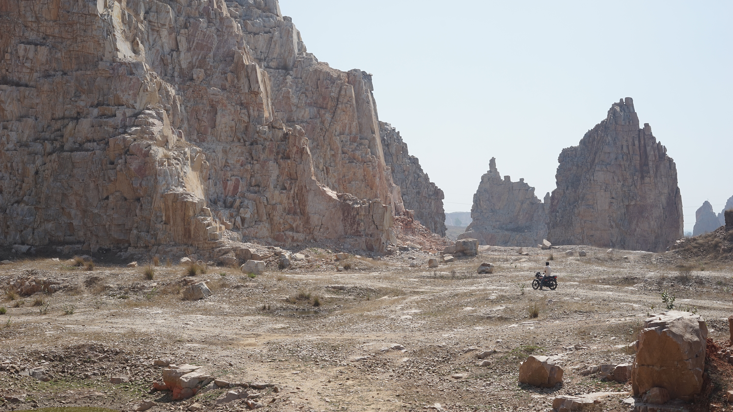
An illegal quartzite quarry in the revenue wastes (Banjad Beed) of Kahrani village in the Aravalli District of Alwar.
However, this trope has also helped mobilise various forms of activism that seek to protect the Aravallis through instituting regulations and mining bans. Amita Baviskar (2011) describes such activism as ‘bourgeois environmentalism’ under which as Crowley (2020: 15) claims there is a hypocrisy through which the middle-classes act to disconnect their consumption from their environment through turning the Delhi Ridge into an isolated ‘nature’ space, strengthened by further bordering. Furthermore, Sivaramakrishnan (2017) highlights how the emergence of an urban ecological imagination since the 1980s has turned the Indian judicial system into an important site of environmental governance. The work of prominent environmental lawyers like MC Mehta, who through two prominent cases in 2004 and 2009 concerning air and noise pollution in Delhi was able to secure bans on mining and polluting industries in and around Delhi is often used to exemplify ‘bourgeois environmentalism’ (Crowley, 2020: 55, 56, 196). While middle-classes are indeed complicit in the aesthetic-political regimes that justify spatial segregation (Waldman, 2022), putting their activism at the centre of the enclosure and exploitation of the Aravalli landscape unintentionally absolves the role of the state and its governmentality within which such forms of bourgeois environmentalism emerge. In fact, it is not merely the activism by the middle-classes but rather ‘judicial activism’ (Bhan, 2016) through which the day-to-day governance of Indian forests has been taken over by the courts (Rosencranz and Lélé, 2008: 11). To understand how the Aravalli landscape is subject to the multiple intersectional value-seeking processes such as mining, rewilding, energy programmes, infrastructure development, and real-estate enclosures there is perhaps a need to centre the analytical focus on the role of the state and its wasteland politics while being attendant to bourgeois activism.
The ‘Aravalli Region’ was defined and politically constructed as a state space (Brenner and Elden, 2009) through a 1992 government Notification issued by the Ministry of Environment and Forests. The Notification defined the ‘Aravalli region’ as a section of the Aravallis in the Delhi NCR within which certain activities such as mining, construction, and the cutting of trees linked with environmental degradation were prohibited unless permitted by the state (MoEF, 1992). The Notification firstly associated environmental degradation in the region with the transformation of the Aravallis into waste, and secondly and more importantly it was able to consolidate an over 250-kilometre-long stretch of the Aravallis fragmented over the revenue departments of hundreds of individual villages and administrative districts across the federal states of Delhi, Haryana, and Rajasthan as a state space. This territory defined as the Aravalli Region under the Notification included ‘any area that fell under the Punjab Land Preservation Act (PLPA) of 1900 such as reserve and protected forests’, or any other area shown as forest in the land records maintained by the state government, and the Sariska National Park and Sanctuary in addition to any ‘revenue waste’ of villages such as ‘Gair Mumkin Pahar [uncultivable hill], Rada [hillock], Behed [ravine], Banjad Beed [stony land], and Rundh [grazing commons]’ in the Delhi NCR. The construction of village commons as ‘revenue wastes’, as empty spaces available for state appropriation and their territorial consolidation as a wasteland for environmental and resource management hold significant resonances with its colonial usage.
In fact, PLPA, the act on which the definition of the Aravalli Region is premised upon was enacted in a similar in response to a perceived ‘environmental degradation’ of rapid hill slides and soil erosion in the late 19th century that were posing a threat to the arable lands of Punjab province in Colonial India. Brandis (1897: 64) notes the following about the environmental crisis preceding the PLPA at the time: Formerly these hills [the Shivaliks of Punjab] were fairly well wooded. In 1846 they became British territory, the consequence was a rapid increase of population, a great demand for wood and charcoal in the fertile plains of the Hoshiarpur and the adjoining Jalandhar district, and the flux of a floating population of graziers with large herds of cattle. The result was complete denudation of the hills. The soil, no longer protected by vegetation, was washed down, broad rivers of sand spread into the plains below, and the end has been, that fields and gardens of 914 villages, once prosperous, are now covered with sand which had laid waste upwards of 70,000 acres of fertile lands.
Arboreal biopolitics
The ‘Wastelands Atlas of India’ (GoI, 2019), which uses remote sensed canopy-cover based classification to categorise landscapes describes much of the ‘Aravalli region’ as an ‘open scrub’ (classification for tree cover between 10% and 40%) and ‘under-utilised/ degraded scrub forest’ (tree cover below 10%). The scrub forests which are characteristic of the native vegetation in the Aravallis becomes an attribute for the construction of the landscape as wastelands that need to be improved through forestry programmes or be brought under other productive uses. However, the narratives of arboreal biopolitics projected on the landscape are constantly rearticulated. For instance, in the 1990s, the region was subjected to the EU-funded wasteland development programme referred to as the ‘Aravalli Project’ in response to the ‘global fuelwood crisis’ (Srivastava and Kaul, 1995; Mahiri and Howorth, 2001). As a part of the project, close to 38,500 hectares of common lands in the Aravallis were planted using the fast-growing Prosopis Juliflora 2 tree, which is referred to colloquially as Mesquite or Vilayati Kikar (KUMAR et al., 2000: 97).
In 2017, the Haryana government attempted to remove this very Prosopis Juliflora tree from the list of trees protected under the PLPA legislation, claiming that it was an ‘alien invasive species’ (Kumar Sambhav, 2017), which ironically the state itself had planted only two decades earlier. The tree, formerly introduced to eliminate wastelands, has now become the very condition for classifying these lands as ‘waste’, further underscoring the political construction of ‘waste’ as a category (Baka, 2013). In fact, ‘since the 1970s, trees have been central to India's wasteland development and enclosure practices’ (Hesse et al., 2016: 652). More recently plantations in the Aravallis under ‘greening’ programmes such as the Green India Mission under the National Action Plan for Climate Change (NAPCC) are being used to produce tradable carbon credits.
These forms of wasteland development programmes operate routinely in intersection with other forms of value seeking processes such as infrastructure development. I will highlight this through discussing the emergence of a flashpoint over a road building project later in this paper. However, there are also ongoing attempts to open this territory to other value seeking processes through deregulation. In February 2019 for instance, the state assembly of Haryana passed a controversial land act known as the PLPA Amendment Bill (Arora and Saini, 2017). The Bill proposed to deregulate approximately 60,000 acres (242 sq.km.) of Aravalli Forest land falling under the metropolitan development plans of the cities of Gurgaon and Faridabad from PLPA protections enacted in the 1970s. Following this the revenue wastes of villages under the regulatory enclosure of the PLPA would become available for real estate development and mining. Furthermore, the PLPA Amendment Bill also proposed to retrospectively legitimise any buildings and real estate enclosures that came up in the PLPA protected areas after 1966. The complicated statecraft first allowed to consolidate the Aravalli landscape into a regulated territory through constructing it as a wasteland and then eventually open it for urbanisation.
Similarly, the mining bans enforced through the Aravalli Notification have had little to no effect in halting mining activity in the Aravallis as the materials required for the rapid construction of infrastructure and buildings in the region generates a great demand for their mining. Such bans have instead pushed mining activity into the distant parts of the region which are outside the sensorium of the urban middle-classes. The former grazing commons of villages classified as banjar (stony/barren) ‘government wasteland’ in the regulated Aravalli landscape become available for mining through government licences. However, due to the disruption of communal ownership, many of these mines can extend far beyond the area for which they are granted a licence (see Chakravartty, 2012). Ironically, it is the communities inhabiting the Aravallis that are often blamed for the environmental degradation in the Aravallis as ‘wasteland users’. This has often resulted in violent evictions such as those at a former mining site in Khori (Menon and Kohli, 2021) and the continued eviction of agro-pastoral communities that have inhabited the core and reserve areas of the Sariska Tiger Reserve establishing in the process a firm ‘nature culture divide’ (Rangarajan, 2018: 4, 6).
The modalities of the sacred
Before the classification of the Aravalli landscape as revenue waste during the colonial period, it was characterised by a large number of sacred groves. In one of the first exhaustive accounts on Indian Forestry systems, Brandis notes the following about their presence in the Aravalli region: Very little has been published regarding sacred groves in India, but they are, or rather were, very numerous. In the dry region, sacred groves are particularly numerous in Rajputana [contemporary Rajasthan]. In Mewar, they usually consist of Anogeisuss pendula, a moderate sized tree with small leaves, which fall early in the dry season, in December and January. Before falling the foliage of these trees turns a beautiful yellowish red, and at the season these woods resemble our Beech in autumn. These groves were, as a rule, never touched by the axe, except when wood was wanted for the repair of religious buildings or in special cases for other purposes. (Brandis, 1897: 12)
The sacred of the sacred Groves
The sacred groves have and continue to serve as sites for foraging and social reproduction especially for the landless and pastoral communities in the villages of Alwar district. Agrarian communities in the region rely upon the sacred groves for access to medicinal plants, fuelwood, fodder, and sources of water especially during the periods of prolonged drought (Pandey, 1999: 1). Additionally, the sacred groves have also served as sites where communities have practiced spiritualism through cultivating interspecies bonds through practices like chugga dalan (laying out bird feed), which they believe serves as a link to the divine.
In the Aravallis, the sacred groves are referred through several colloquial terms such as kankar bani, rakhat bani, dev ouranya, orans, vall and dev bani. They usually have a folk deity (dev) housed in a sanctum considered to be the guardian of the forest. Oran committees constituted by the village councils (panchayats) look after the governance and upkeep of the sacred groves. They often enforce and collect fines on the cutting of trees in the sacred grove and organise pilgrimages and annual festivals where donations and pledges for the upkeep of the sacred grove are collected. These committees usually manage the funds and channel them into the maintenance and upkeep of the sacred groves. In his book ‘Trees of Delhi’, Pradip Krishen (2006: 25) conjectures that it is the still active socio-religious beliefs in the Mangarbani Forest that is the reason behind the dense cover of the sacred Dhau (Anogenissus pendula) 3 trees over its steep valley slopes. Krishen finds that not only is Mangarbani relatively free from the feral Vilayati Kikar (P. Juliflora), but it still holds many native tree species that have disappeared elsewhere in the Delhi Ridge. The customary law in the sacred groves which prohibits the cutting of trees often codifies resource management systems as adaptive responses (Berkes, 2017: 261). The cutting of native trees like Dhok is prohibited for their intrinsic use value for nutrition and medicine for the community. The leaves of Dhok tree for instance are extremely protein rich and are linked with increased milk yields in livestock, additionally the gum raisin from the tree is used for the treatment of gastric disorders (Nainwal and Verma, 2018: 38). This is a markedly different view than that of the forest department, which in their plantation drives in the region prioritise the fast-growing P. Juliflora for greening and its exchange value as fuelwood.
While the presence of these sacred groves over uncultivable hills has posed little threat to their continued existence as deemed commons, increasing urbanisation and land pressures including illegal quartzite mining, elite enclosures for nature and religious tourist retreats, and state-led infrastructure and carbon offsetting projects have led to increased contestations over their ownership. Even though the village communities continue to revere the sacred groves, following the Aravalli Notification of 1992, the ownership of all uncultivable hills in the Aravalli region has been transferred to the forest department. This contrast between use and ownership is exploited by the forest department not only to further entrench a nature-culture separation, but often also to justify illegal enclosures such as eco-tourist complexes and mining.
I would like to highlight these frictions using the example of the sacred grove of Bhakatpura village located close to the buffer zone boundary of Sariska Tiger Reserve. The sacred grove is located over a hill and is spread over spread over 10 hectares with the sanctum of a folk deity Bhairu ji located atop the hill. The grove overlooks a manned check-post of the forest department. The differences between the landscape of the tiger reserve and the sacred grove become immediately apparent, with the predominance of P.Juliflora in the former and Dhok in the latter. Since early 2000s, there have been repeated attempts to wrest control over the sacred grove including an attempted occupation of the hill by a mining group from Southern Haryana and attempts to establish an eco-recreation centre here for a nearby resort by the Indian Hotels Company Limited 4 . One still observes the scars from attempted mining on the southern end of the sacred grove. The inhabitants of Bhakatpura that I interviewed described how the attempts to occupy their sacred grove have been carried under forest department's watch and have exploited its contested land ownership. ‘The forests department check-post is merely 100 metres away, how can such things happen without their collusion’, an inhabitant from Bhakatpura remarked during an interview.
Owing to the attempts to exploit the contested ownership of the sacred grove to illegally occupy it, the performance of the sacred serves the purpose of contesting land rights and resisting state-led expropriation. KRAPAVIS, which runs a native tree nursery and resource and training centre for community conservation close to Bhakatpura village attempts to strengthen the community's conservation attempts. According to Aman Singh, there have been similar attempts to expropriate the sacred groves of other communities in the region. ‘Our work attempts to bring these struggles together around the mobilisation of sacred as a value of community conservation that can counter their portrayal as wastelands’, he adds. In addition to its counter-mapping and native planting work in region, since the early-2000s, KRAPAVIS has been publishing the Hindi-language newsletter Devbani re baat (the voice of the sacred grove), which is circulated to over 200 villages across Alwar district. The newsletter disseminates stories about successful eco-restoration projects, information over forest rights and evictions, upcoming festivals in sacred groves, and stories about pastoral traditions in the region. In addition, KRPAVIS runs the Oran Forum (Sacred Grove Forum), a grassroots advocacy group largely composed of community members drawn from various villages around the Alwar district along with environmentalists, academics, and policy experts. The Oran Forum advocates for community land rights, biodiversity conservation, and writes policy recommendations for the government.
These ideas over community conservation are often conditioned through KRAPAVIS's transnational links with policy organisations such as with the Geneva-based International Consortium of Community Conserved Areas (ICCA). For KRAPAVIS, the ‘sacred’ offers a counter-value to the idea of ‘waste’, allowing the forests to become a site of enchantment and of meaning (Bennett, 2016) as complex multispecies ecologies and therefore sites for resistance against land expropriation. While not opposed to ferality of introduced tree species such as P. Juliflora, native tree planting helps maintain local biodiversity serving the strategic purpose of strengthening the sacred meaning and autonomy over space in addition to landscape restoration. However, as Aman Singh insists, this approach is only useful in villages that still have a large agrarian base, in places where agrarian land has been transformed into ‘properties of rent’ (Pati 2022, Cowan 2023), the sacred has taken another ontological meaning that has little to with social reproduction.
Faux-sacred nature
The performance of the ‘sacred’ can also often become completely detached from its socio-ecological significance and instead serve as a driver for the further commodification of space. Such landscapes bear resemblance to what Sanjay Srivastava (2009: 191) describes as ‘Disney-divinity’ and Kajri Jain (2017) as artificial nature. Such renditions of the sacred attempt to project the ideas of a pristine past where in responding to demands for greenness ‘nature is divorced from organic life’ (Jain, 2017: 113). I encountered several former sacred groves in the Aravalli districts of Haryana where the temple councils largely composed of landed elites and local politicians from the villages have wrest control over the sacred groves erecting palatial complexes catering to religious mass tourism. One such sacred grove, Baba Puranmal ki Bani located between the villages of Kasan and Khoh in Manesar illustrates the paradigm of what I describe as faux-sacred nature.
Baba Puranmal ki Bani overlooks the giant manufacturing plant of Maruti-Suzuki located in the Industrial Model Township (IMT) of Manesar. The agrarian land of Kasan and Khoh villages was expropriated in the early 2000s for the construction of the IMT which came up here as part of an Indo-Japanese collaboration. Following land expropriation, most local inhabitants from Kasan and Khoh went into rental businesses and real-estate development to cater to the flux of labour migrants in the region. Neither did the IMT masterplan cater to the housing of labour migrants nor to the environmental rehabilitation of uncultivable hills in Manesar (see – Bathla, 2021). The uncultivable hills were marked as scrub forest, which was to be further forested using fast growing trees like P. Juliflora, which took place through the EU-funded Aravalli Project discussed earlier in this paper. While some old thickets of the sacred Dhok tree still survive on the slopes of the sacred grove, there are little signs of natural regeneration or restoration to be seen. While a temple council still exists, its role too has shifted into transforming the sacred grove into a property of rent.
The small sanctum which housed the folk deity of Baba Puranmal has been expanded into a sprawling temple complex whose boundaries now cover much of what used to be the sacred grove. The temple council still collects funds from visitors and pilgrims, and rents from the businesses that run within the temple complex but invests them in a form of greening where the idea of the sacred is ontologically vastly different than the sacred of the sacred grove that we witnessed in the previous section. Instead of facilitating the regeneration of the grove, these funds are often invested in producing an artificial or faux nature with bucolic scenes that attempt to recreate a distant Edenic past. The temple complex today stands adorned with an assemblage of concrete and gypsum sculptures depicting scenes of nature from Hindu mythology set within heavily horticultured lawns. Specifically in this case, there are scenes with the pastoral deity of Lord Krishna holding the mythological hill Govardhan Parvat, surrounded by artificial animals, birds, and trees, and water fountains (see Figure 3). A giant 12-metre-high statue of Lord Shiva set within a horticulture lawn rises above this among other scenes with two large elephants adorning the entrance to the complex.
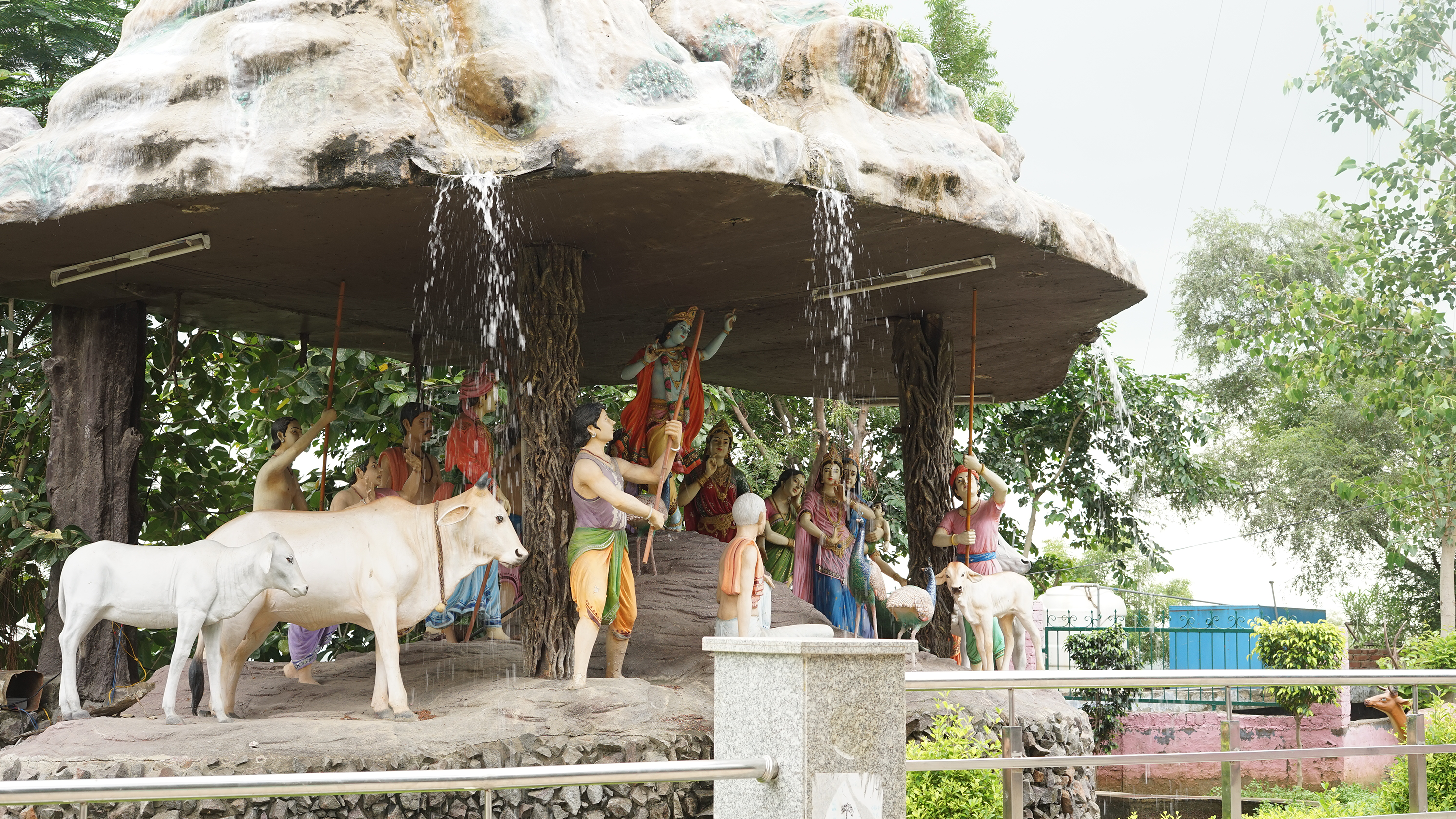
Disney-divinity – A fictional sacred landscape drawn from Hindu mythology in the former sacred grove of Kasan and Khoh in the Aravalli district of Gurgaon.
In my discussions with the inhabitants and migrants in Kasan and Khoh it emerged that due to the transition of the village from agrarian to rental economy, the sacred grove does not hold the same ecological significance anymore. The sacred detached from its ecological significance is exploited by the local caste and political elites that control the temple committees to produce a bucolic imaginary, which to borrow from Jain (2017: 124) provides a fecund ground for religious nationalism. Instead of being hidden in a sanctum, such monumental scenes of gods are situated directly within the landscape (Jain, 2021: 195). Thus, in the postliberal urban transition beyond the city in India, spectacles of idol building allow to put places on the map, thus legitimising territorial enclosure (Jain, 2021: 26). Here the sacred then becomes complicit and acts within wasteland governmentality and environmental idealism. In the following section, I will discuss a third modality of the sacred that is attendant to specificities of landscape and biodiversity and anthropogenic change and seeks to restore them not to an Edenic past but rather into sites that can help resist larger political attempts by the state and private actors at enclosure.
Trouble over a road and a new sacred forest in Gurgaon
In the Autumn of 2018, a large protest broke out in Gurgaon over an unsolicited proposal for the construction of a road through the Aravalli Biodiversity Park (ABDP). The Park located over a former mining site in the uncultivable hills of Nathupur village at the border between the cities of Delhi and Gurgaon was undergoing restoration into an ‘urban forest’ through a decade-long initiative by the citizen group IamGurgaon (IAG). According to Vijay Dhasmana, the head gardener of ABDP ‘the distressed landscape of the mining site had only recently gone into regeneration after the sustained efforts of citizen volunteers over a decade, turning into a self-sustaining mixed deciduous forest, with trees recruiting new offspring and seedlings’. According to the surveys conducted by citizen science groups, the park harbours close to 300 species of native vegetation, many of them reintroductions into Haryana from across the Northern Aravallis (IAG, 2020: 18). There have been sightings of over 200 species of birds in the park, along with animals, snakes, insects, butterflies, and moths (IAG, 2020: 42). The park then is a classification category imposed by the citizen–municipal partnership over a site whose sensorium is reminiscent of what James Scott (1998: 22) would describe as a naturalists’ forest.
According to Vijay and others from IAG that I interviewed, the experimental approach to rewilding in the park drew inspiration from the sacred groves in the region such as Mangarbani and in Sariska, Alwar. Instead of the state horticultural approach of ‘greening the wasteland’ through rapidly planting saplings, bringing tonnes of soil to the site relocated from elsewhere, and constantly injecting water extracted from far away aquifers, the park worked with the anthropogenic scars of mining in the landscape with an intention to restore the soil, work with local biodiversity, and recharge groundwater aquifers. ‘The inspiration from the sacred groves of Aravallis is aptly evident in ABDP’ as Aman Singh from KRAPAVIS remarked during one of our visits to ABDP in 2019. Strolling through the park, it is often easy to forget that one is still in the middle of the city of Gurgaon, or that this site, only until a decade ago, was an almost barren stone quarry. All around the park, in full view, is a thriving multispecies transect with flowering trees, understorey bushes, grasses, and tree offspring sprouting beneath mature specimens. What were once mining pits today stand covered with thickets of the famed native Dhok tree (Anogeissus pendula). Here I would concur with Crowley (2020: 245 emphasis added) in noting that ‘drastic human intervention like quarrying need not spell the death of the ridge, it can provide micro habitats if given care, space and time to regenerate’ (see - Figure 4).
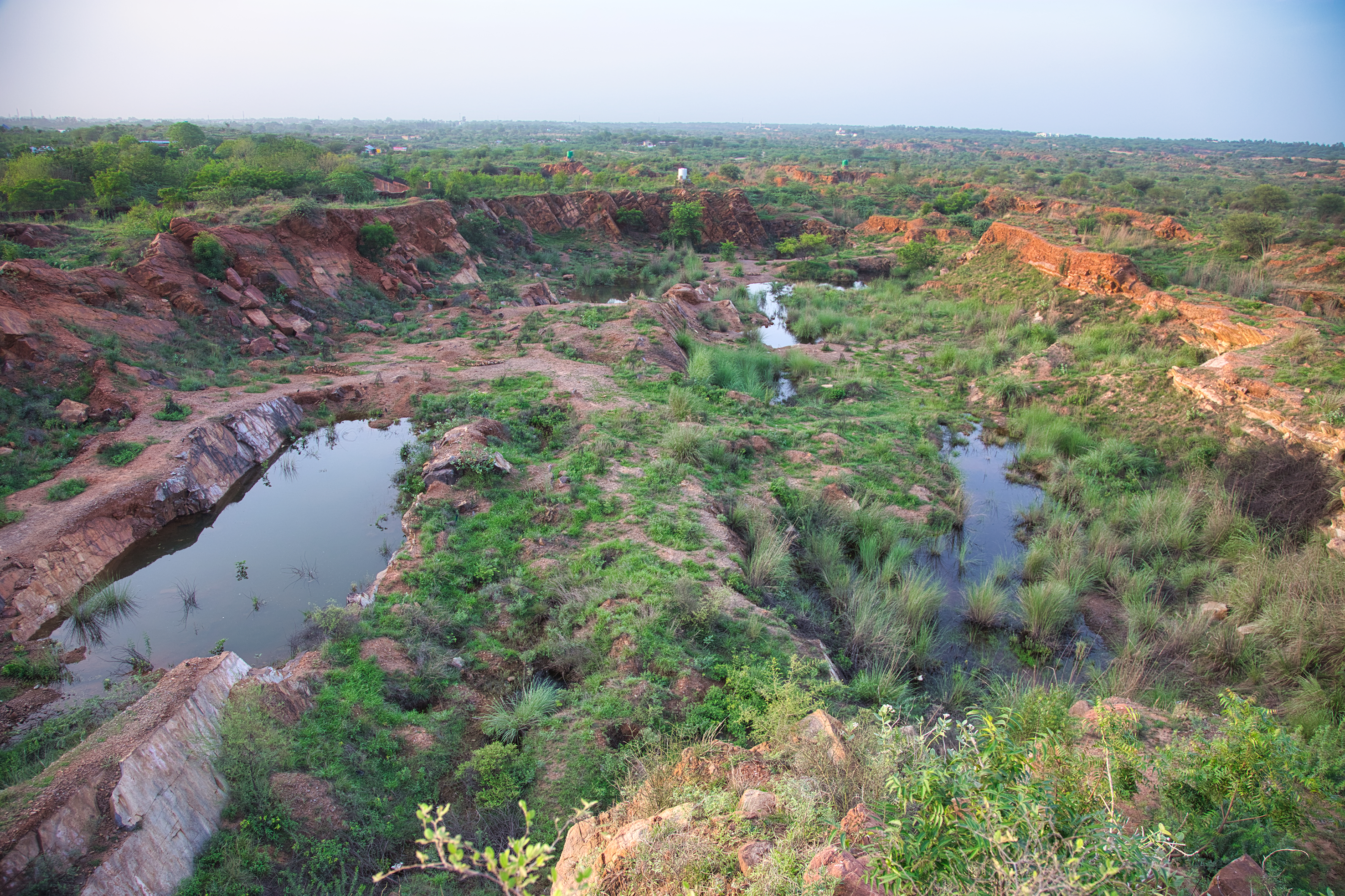
An aerial view of a mining pit at the Aravalli Biodiversity Park, which turns into a seasonal body of water and provides a crucial habitat for several types of tree that require well-drained rocky slopes. Credits: Vijay Dhasmana.
This experimental approach, which I would like to term as ‘restorative commoning’ required not only convincing the municipal body to abandon their ‘greening’ method, but also for the IAG itself to rectify and correct their own complicity in wasteland governmentality. In partnership with the Municipality of Gurgaon, IAG initially intended to plant trees at the ABDP as a part of their ‘million trees programme’, which intended to sequester about 9645 tonnes of carbon dioxide annually to help Gurgaon offset its carbon footprint (Raina, 2011). This approach was indeed in the realm of what Davis and Robbins (2018) would call ‘arboreal biopolitics’. However, there was a moment of transition when according to Swanzal Kapoor, the founding director of IAG, they realised that while such approach was useful for attracting financial pledges 5 , they do little for environmental restoration and for building communal bonds. The IAG thus reached out to environmentalists such as Pradip Krishen who has written extensively on trees in the region and Vijay Dhasmana who specialises on the Aravalli ecology. This contact made IAG draw inspiration from sacred groves in the region and respond to the geological and environmental specificities of the site. The idea was not to uproot any existing trees whether non-native, but rather to plant native trees that were particularly adapted to the local terrain and climatic uncertainties. For instance, the thin-leafed plants such as Babool [Acacia nilotica] were planted to form a foliage at the top, which would filter the sun for broad-leaf plants like Kaim [Mitragyna parviflolia] that were planted in between and Boswellia [Indian Frankincense] tree in the rocky parts. The idea was to catalyse a self-regenerating forest system with an interspecies mix that would mimic the forests that might have originally been here albeit conditioned through anthropogenic change such as the scars of mining and the feral ecology. Furthermore, as the restoration effort was led through citizen volunteers and was synchronised around more-than-human time, it galvanised new communities of care around it drawn both from the middle-classes and from agrarian villages in the region. Barefoot botanists learning to identify trees, bird watchers, people getting to know the animal and tree species they co-habit the city with, about interspecies relationships, people learning about soil regeneration, about groundwater recharge. The project allowed for a space of repair human and non-human relations disrupted by colonial and post-colonial modernity (see also Barua 2023).
However, as the landscape had started to go into regeneration, the unsolicited road proposal threatened to disrupt the site once again. According to Vijay ‘the road would completely destroy this 380-acres of rewilded space’, and it therefore triggered protests and demonstrations. Documents accessed through a Right to Information (RTI) filed by a local activist Bincy Mary George revealed that the economic rationale around the planning of the road through the park was to find the cheapest pathway for the development utilising government wastelands instead of private property (AECOM, 2018: 9). Contrary to the ongoing restoration of the site into a mixed deciduous forest, it continued to be classified as a mining wasteland in terms of its landuse. The protest group, which coalesced as the ‘Save the Park Movement’ asserted for the Park to be protected as a ‘deemed forest’ 6 . Rejecting technomangerial solutions such as the proposal for elevating the road on stills, claiming that given the environmental crises in the region further roads were not needed in the first place. During the first of such demonstrations organised in the Autumn of 2018, over a thousand residents from across Gurgaon gathered at the amphitheatre located inside the park (Pant, 2018). People shared stories about their associations with its inter-species ecology and pledged to protect it as their ‘sacred forest’ (Nath, 2018).
The ‘sacred’ here was perhaps in reference to the ‘sacred groves’ in the region by which the park was inspired in the first place. It is as if the term had come a full circle. The site which, decades ago, would probably have been a ‘sacred forest’ for the adjoining agrarian villages before turning into a mine, had turned ‘sacred’ again. The sacred here, however, rather than standing for something esoteric and animistic (see Harvey, 2005), or for an Edenic past represented through faux nature as we saw in the previous section, like its evocation among communities in Alwar becomes a socio-political projection to resist state-led expropriation of land through reenchanting landscapes. A month later almost 5000 school children from across Gurgaon turned up for a protest at the park, underscoring the chronic air pollution crisis in the region and reiterating that saving the park was essential to their ‘right to breathe’ (David, 2018). Other prominent voices, such as environmentalist Chetan Agarwal, opined that the road would fragment the larger ecological corridor in the Aravallis. The Facebook page of the group acted as a platform where information regarding the impact of the road was shared, and collective mobilisations against its construction planned.
Following months of sustained protests, the NHAI put the plans for the road on hold in December 2018 (Thomas, 2018). However, the sentiment among the ‘Save the Park’ movement was that the plan for the road was linked with political economy of neoliberal urbanisation in the region and they would resurface in other forms and at other sites once the momentum behind the protests had softened. Not only did the plans for the road remerge, but the Haryana government attempted to deregulate the PLPA protections for the Aravalli landscape altogether through passing the PLPA Amendment Bill. This as I discussed earlier would help open 60,000 acres (242 sq.km.) of forest land in the Aravallis for development and mining. This was a major turning point for the ‘Save the Park’ movement, which turned its demands into ‘Scrap the PLPA Amendment’ and ‘Save the Aravallis’ protests (Ahlawat, 2019). The logo of the movement perhaps reflecting this featured three clenching fists rising above the Aravalli hillocks. This was perhaps due to the realisation that the contestation was not over one park, but what was at stake was the ‘complete urbanisation’ (Lefebvre, 2003 [1970]) of the ‘Aravalli region’.
Urban environmentalist counter-movements (Polanyi, 2001) in the region such as the one that coalesced around the ABDP have often been categorised through binary framings of bourgeois environmentalism versus the environmentalism of the poor (Baviskar, 2011). Classifying the ABDP as a case of ‘bourgeois environmentalism’ Shubra Gururani (2019: 217) for instance claims that ‘their interventions have been ad hoc, taking up issues on a case-by-case basis and not aimed at seeking any broader or regional change that could address issues of social and environmental justice and equity’. If seen in isolation, the ABDP can indeed seem like an ad-hoc case of ‘bourgeois environmentalism’ acting under wasteland governmentality. While indeed several of the founding members of the movement are from the middle class, the movement and its aims are much broader and not necessarily opposed to the environmentalism of the poor. The larger landscape scale analysis discussed in this paper highlights how agrarian communities in the region that might be considered poor deploy the sacred in similar ways. Furthermore, we saw how the landscape restoration in the park catalysed resistance not only against unsolicited road building, but also against enclosure through environmental deregulation in the larger region. Thus, the binary classification of ‘bourgeois environmentalism’ applied to the Park Movement seems inadequate in understanding the liminal counter-movements that are attendant to ‘nature in the extended city’ (Nagendra, 2016 emphasis added).
The much-famed sacred forests in the region far from being Edenic are in fact anthropogenic and believed to be not more than a few hundred years old. As Aman Singh once remarked during an interview; ‘oral histories tell us that the sacred forests in the region are not in fact ancient but rather medieval, they have been nurtured and protected as sacred due to the immense ecological significance and resilience of the native trees. The changing conditions in the region would require a tapestry of alternatives, while existing sacred groves need to be protected and strengthened, in places like Gurgaon, where they have already been deeply depleted through mining, new communities and new types of sacred forests need to emerge’. IAG has been attempting to revive and forge new communities around other fragments of agrarian commons and infrastructure that have become a part of the city, these include check-dams or bundhs, ponds, and other mining sites. It recently revived a 5.2-kilometre-long strip forests along the Chakkarpur Wazirabad Bundh along with the restoration of the Sikanderpur watershed and forest restoration and the restoration of Badhshahpur forest corridor (Pant, 2019). Additionally, a few other forest-parks are in the pipeline. These sites are publicly accessible and attract a diversity of publics including migrants who short cut from one part of the city to the other through them, or come for strolls, residents of villages, residential colonies and tenements that abut these sites, as well as amateur naturalists who come to experience and form bonds with the diverse flora and fauna that has sought refuge in these sites.
IAG and the broader community that has coalesced around the various eco-restoration sites they manage rather than seeking to expand into the entire Aravalli landscape use these sites to restore and repair not only anthropogenic scars in the landscape but also the broken relationship between the inhabitants and their immediate environments. Thus, drastic human intervention in the Aravalli Region is not only opening micro habitats, but also opening opportunities to build new socio-ecological relationships of care and community building (see Just, 2022; Markaki, 2022).
Discussion – restorative commoning as anti-wasteland politics
At a time when as Ghazala Shahabuddin (2020) aptly points while the overall forest cover in the Aravalli Region seems to be increasing through greenwashing, the region is facing an extreme biodiversity loss. It is pertinent then to ask as to exactly what kind of forests will survive under wasteland governmentality in the region? The emergent restorative commoning, as we saw in the case of the ABDP and CWB, seeks to undo biodiversity loss and localise metabolic dependencies rather than border, or project fear upon, near and distant places. Rather than manufacturing an Edenic past, these restorative commoning movements attempt to work with the potentials presented by highly anthropogenic landscapes. Rather than force the eviction of vulnerable social classes, it seeks to be inclusive, through opening spaces of contact and knowledge production, and envisioning alternatives. Restorative commoning, seeks to undo the emptying of meaning, and can thus be understood as an anti-wasteland politics that seeks to common the wastelands of extended urbanisation for a ‘city that is yet to come’ (Simone, 2004). A crucial facet of restorative commoning exemplified in the park is the community that has galvanised around it, which is attendant to the sensorium of the larger Aravalli landscape and resists its erasure. Furthermore, as Tomaz Mastnak and colleagues (2014) aptly argue, rather than equating native plant advocates with anti-immigrant nativism, it should be seen as part of a broad process of botanical decolonisation and a strategic location for ethical action in the Anthropocene. ABDP's anti-wasteland politics that redeploys ideas around native planting and the sacred for landscape repair and commoning is still a countermovement in response to unchecked market exchange of fictitious commodities such as land, labour, and money (Polanyi, 2001: 76). However, slight changes in its course and further alignment with marginal communities can make it tip towards a radical direction. This paradigm is relevant for the extended cities not only in India but cities everywhere that are being reshaped through the forces of extended urbanisation.
Highlights
This paper explores the political construction of the Aravalli region as an extended urban nature accompanying Delhi's extended urbanisation.
The paper explores how wasteland governmentality acts upon extended urban nature through deploying waste as a landuse classification cyclically.
The paper follows the historic and ongoing construction of the sacred as an alterity and its cooptation Hindu nationalism.
The paper discusses redeployment of ideas around native planting and sacred ecology for repair and commoning by urban movements.
This paper proposes restorative commoning as a liminal paradigm of anti-wasteland politics beyond the binary categorisations of environmentalism.
Footnotes
Acknowledgements
A version of this paper was presented at the City and the Wild workshop at Collegium Helveticum in April 2022. The author would like to thank Tea Lobo the organizer of the workshop for her feedback. Additionally, he would like to thank Stefan Laxness who has been a crucial interlocutor for the concept of restorative commoning presented in this paper. A part of this research was conducted through New Urban Agendas under Planetary Urbanisation module at the Future Cities Lab Global at ETH Zurich. He would like to thank Milica Topalovic and Christian Schmid, the principal investigators of this module. Future Cities Lab Global is supported and funded by the National Research Foundation, Prime Minister's Office, Singapore under its Campus for Research Excellence and Technological Enterprise (CREATE) programme and ETH Zurich (ETHZ), with additional contributions from the National University of Singapore (NUS), Nanyang Technological University (NTU), Singapore and the Singapore University of Technology and Design (SUTD).
Declaration of conflicting interests
The author declared no potential conflicts of interest with respect to the research, authorship and/or publication of this article.
Funding
The author received no financial support for the research, authorship and/or publication of this article.