
Abstract
Despite the emergence of virtual spaces as arenas for public participation, the geographies of digital participation have gained relatively little attention. Besides considering who participates and why, there is an evident gap in research considering the spatial relationships between the participants of digital urban planning processes and the spaces that are the subject of their participation. This paper proposes a working concept of the spatiality of participation that distinguishes between the spaces in which participation occurs, the spatial realities of the participants, and the spaces as objects of participatory planning. Relationships between these dimensions are investigated empirically with a Public Participation GIS study set in Espoo, Finland, involving 1,731 citizens and over 6,800 future planning and development ideas mapped across the city. The results of the study support prior research observing that e-participation has the potential to spatially expand participation processes both in terms of the involved public and the spatial knowledge they produce. However, our results also show that online participation may capture spatial ties between people and places that differ from those of traditional participation modes, ranging from place-protective behaviors close to the residential location to more casual spatial attachments.
Keywords
Introduction
Over the past two decades, the availability of tools and methods to facilitate participatory urban planning has significantly expanded (Hossu et al., 2022; Nyseth et al., 2019). Notably, the development of e-participation tools has introduced new ways for involving citizens in participatory urban planning, complementing traditional ways of organizing participation, such as public hearings and meetings (Afzalan and Muller, 2018; Akmentina, 2023; Ertiö, 2015; Falco and Kleinhans, 2018). Previous studies reviewing the advantages and challenges of e-participation suggest that online participation tools have the potential to scale up participation in participatory urban planning processes in multiple ways. When implemented successfully, they can increase the overall number of participants, broaden the spatial extent of participation, and engage participant groups that are often underrepresented in public meetings (Afzalan and Muller, 2018; Donders et al., 2014; Kahila-Tani et al., 2019). At the same time, challenges remain in ensuring the inclusive and transparent use of e-participation among other modes of public participation (Afzalan and Muller, 2018; Falco and Kleinhans, 2018; Kahila-Tani et al., 2019) and in assessing the influence of e-participation on planning outcomes (Staffans et al., 2020).
Despite the emergence of virtual arenas for public participation that, opposite to many traditional participatory practices, do not require the participant’s physical presence, the geographies of digital participation in urban planning have received relatively little attention in the participatory planning literature. Besides considering who participates and why, there is an evident gap in research examining the spatial relationships between the participants of digital urban planning processes and the physical environments that are the subject of their participation. These spatial relationships are often overlooked by focusing solely on socially constructed space (Hofer and Kaufmann, 2022) or equating the sphere of participation with the “local” environment or community. However, like other emerging location-based services, digital participatory planning technologies are likely to create new geographies that blur the boundaries of virtual and physical environments (Ash et al., 2018; Mitchell et al., 2021; Tarachucky et al., 2021). Thus, with the increasing use of digital technologies in urban participatory planning (Hersperger et al., 2022; Potts, 2020), we argue for the need to better understand the spatial dynamics involved in e-participation processes.
The spaces of citizen participation in urban planning, a working concept.
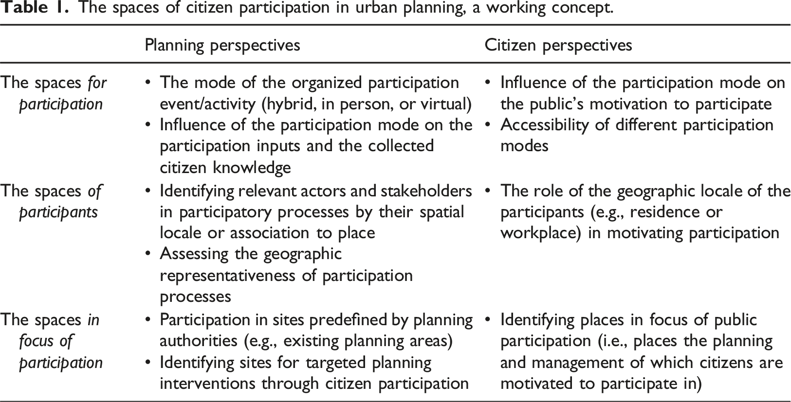
The spaces of citizen participation
The spaces for participation
The most tangible links between space and participation are found in the spaces in which participation occurs, here referred to as the spaces for participation. These may range from physical spaces of diverse character to, following the development of e-participation, virtual spaces. Hofer and Kaufmann (2022) provide a review of the treatment of the spaces of participation in the recent literature, differentiating between studies examining the physical aspects of participation venues and those focusing on socially constructed space. They conclude that the physical spaces of participation have received relatively little attention as most of the literature has focused on socially constructed space. For example, Chilvers et al. (2018) offer a conceptualization of the spaces of participation rooted in a social-constructivist paradigm, in which institutional settings, norms, and practices create space.
The development of digital participatory planning has reinvigorated the debate around the accessibility, trustworthiness, and reliability of both physical and digital participation, and how these may be supported with hybrid applications (Afzalan and Muller, 2018; Falco and Kleinhans, 2018; Pantić et al., 2021; Wilson et al., 2019). This discourse has also debated how the spaces in which participation occurs may influence the public’s motivation to participate. For instance, Pantić et al. (2021) identified low participation costs and reduced time demands as key advantages that motivate online participation. Likewise, Brabham (2012) observed that online participation was often encouraged by low entry barriers and attractive website design. Participation, both digital and onsite, may likewise be motivated by the opportunity to bring one’s own issues to the public authorities’ attention, rather than to discuss planning issues with fellow citizens or participate in tasks given by the public authorities (Ertiö et al., 2016). However, digital participation can be constrained to more rigid structures than in-person interaction, thus limiting the participants’ opportunities to influence agenda-setting and reducing the scope of citizen knowledge that can be gathered (Nummi et al., 2023; Pantić et al., 2021). Moreover, the biases and social hierarchies within the digital public sphere may differ from those present in more traditional fora of public participation (Mattila and Nummi, 2022).
The spaces of participants
In urban planning, public participation is typically organized following the territorial frameworks of the planning authorities. Within these structures, the individual’s geographic location and, consequently, the citizen rights tied to the official status of residency, often guide the identification of relevant stakeholders and stakeholder groups. While this spatial connection is predominantly conceived through the individual’s place of residence, it can be understood across various geographic and planning scales and linked to participants also through other place-based connections, such as places of work, community function, or ownership. Moreover, emerging participatory planning practices also acknowledge citizen knowledge derived from other types of spatial ties and lived-in experiences (Kallio et al., 2015).
However, the criteria for stakeholder involvement may differ between statutory and more informal participatory planning practices. In statutory planning practice, stakeholder identification is ultimately tied to the normative requirements of the local planning legislation. For example, the structure, actors, and objectives of the Finnish statutory land use planning system are outlined in the Finnish Land Use and Building Act. The law defines stakeholders as landowners within the planning area and as individuals whose living, working, or other circumstances are significantly affected by the plan (Land Use and Building Act, 1999/132 § 62). In practice, the affected groups are identified by the planning authorities, thus making stakeholder involvement a locally specific challenge (Bäcklund and Mäntysalo, 2010). By contrast, informal participatory planning practices are not restricted by the participation requirements of the planning system, granting planning organizations and individual planners more flexibility in organizing participation as they deem appropriate (Mäntysalo et al., 2015). As informal participation practices allow for greater flexibility in their structure, they may employ alternative methods for representing plans and spaces and target specific geographic areas and stakeholder groups.
In the planning literature focusing on public participation, the question of who should be involved in participatory processes as part of the public has been discussed extensively. In an early synthesis of this literature, Schlossberg and Shuford (2005) separated between arguments concerning the influence of planning decisions on specific segments of the public (“those affected by a decision”) and arguments concerning the potential contributions of the public (“those who can provide valuable knowledge or information for a decision”). Translated into the operational levels of planning practice, both lines of argumentation encompass distinctly spatial dimensions, referring both to the spatial extent of plans and people’s spatial practices and experiences. Moreover, the literature has explored how diverse relationships between people and places may motivate participation in planning processes. Examining participation inputs related to an actual planning process, Harsia and Nummi (2024) found that the participants’ personal connection to the planning area was among the most important factors influencing the preferences, arguments, and justifications expressed. Relationships between people and places may also be studied indirectly, as in the theoretical model of participation intentions developed by Li et al. (2020). Here, diverse intrinsic and extrinsic factors were expected to affect citizens’ participation intentions and explain to a varying degree the willingness of citizens to participate on various scales, contents, and processes of planning. A related study by Donders et al. (2014) examined citizens’ intrinsic motives for participation in three categories: public, group, and self-interest. Self-interest was expected to motivate interest in topics related to the participants’ own environment, while group and public interests were expected to reflect common planning interests at the city level.
However, only a limited number of studies has explicitly addressed the spatial relations between the public and proposed plans. This literature has predominantly focused on examining the local residents’ direct opposition against or support for a proposed land use development. In the public discourse, the terms “NIMBY” (not-in-my-backyard) and “YIMBY” (yes-in-my-backyard) have been widely adopted to describe such responses (Devine‐Wright, 2009). While they are likely to simplify the political complexities of local opposition (Gibson, 2005), these concepts remain useful for describing conflicts in local land use development and understanding the motivations for diverse place-protective behaviors (Eranti, 2017). For example, several studies have shown that opposition to urban densification may be motivated by concerns for the loss of perceived environmental quality, urban character, and local lifestyle (McGuirk and Argent, 2011; Vallance et al., 2005). These motivations may emphasize both physical and social aspects of the living environment, the former including concerns for increased traffic, loss of green space, loss of privacy, and increasing building heights, and the latter for the type of future residents that the new housing projects would attract (Haaland and van Den Bosch, 2015; Nematollahi et al., 2016). Locality, in terms of the residential location and its vicinity to the desired or undesired development, is positioned as a significant factor influencing NIMBY responses (Devine-Wright, 2009). In addition to arguments based on private interest and the common good, personal ties to specific places have been identified to motivate NIMBY responses (Eranti, 2017).
The spaces in focus of participation
The knowledge produced during a participatory planning process may also be characterized based on its spatial attributes. While these spaces in focus of participation are likely to intersect with the spaces of the participants, they can also be spatially removed from each other. For example, participation might be encouraged regarding a new development area with no existing inhabitants, or citizens may express interest in the planning of areas with which they have no personal connection. For these reasons, we suggest treating spaces in focus of participation and spaces of the participants as distinct from each other.
Regarding citizen participation in urban planning, the spatial attributes of the spaces in focus of participation may either be evident from the participation input or inferred from the participation context. Multiple participatory planning methods, such as in situ or virtual walkthroughs and participatory mapping activities produce knowledge that is inherently place-based and for which knowledge of “where” is equally important to knowledge of “what.” Such methods provide the participants agency in locating sites for planning interventions. However, more often the spatial attributes of participatory inputs are not explicit, but implied by the participation context (e.g., participation related to a specific plan with its own geographic delineation). In statutory planning, the participation contexts and, by extension, the spaces in focus of participation, are typically predefined by the legal requirements operating on various governance scales (Bäcklund and Mäntysalo, 2010). Thus, zoning plans not only determine areas for future development, but also establish the framework for citizen participation. From a strategic planning perspective, however, public participation can also contribute to identifying areas in need of targeted planning interventions.
The ways in which place motivates engagement in participatory processes have been examined in more detail in the fields of environmental psychology and urban sociology. For example, the theory of geographic discounting (Hannon, 1994) has been used to explore the geographic relations between individuals and their place-based values. This theory proposes that people tend to distance themselves from what they fear or dislike and draw close to things that they like or find desirable. The principle of geographic discounting may be extended to explain some place-protective behaviors, such as NIMBY or YIMBY responses (Brown and Glanz, 2018). Moreover, the concepts of place attachment and place identity are central in studies aiming to understand relationships between citizens and the places that they identify with on a level that may lead to their engagement in participatory planning processes. Place attachment is commonly referred to as an emotional bond that forms between a person and a particular geographical location (Manzo and Devine-Wright, 2014). It may correlate with residents’ social and political involvement, pro-environmental behaviors, and community citizenship behaviors, that is, voluntary behaviors that are not directly monetarily rewarded by a community (Mesch and Manor, 1998; Xu et al., 2022). Attachment to place is also an important predictor of community participation (Anton and Lawrence, 2014; Hesari et al., 2020). Place identity, on the other hand, refers to the ways individuals define themselves through strong affective ties to certain physical settings, such as homes, neighborhoods, or cities (Proshansky et al., 1983). According to Stedman (2002), people are willing to fight for places that are central to their identities as strong place identity and attachment to place foster place-protective behaviors.
Data and methods
Research method
Our empirical case study analyzes data collected using public participation GIS (PPGIS). Over the past three decades, PPGIS has developed into the main participatory mapping method that employs digital tools and focuses on supporting participatory planning processes (Brown and Kyttä, 2014). Benefitting from the use of online mapping interfaces, PPGIS tools enable the large-scale collection of geospatial data produced by participants. From an analytical perspective, such data allows for diverse spatial analyses to identify spatial trends and dependencies (Fagerholm et al., 2021).
Numerous empirical studies have employed PPGIS to understand the relationships between people and their living environments, examining, for instance, potential conflicts in land use (Brown and Raymond, 2014; Kahila-Tani et al., 2016) and residents’ mobility patterns (Hasanzadeh et al., 2017). Moreover, the effect of geographic discounting has been explored in multiple PPGIS studies. These studies have observed that place values tend to cluster around the residential location and decrease in number with increasing distance (e.g., Brown et al., 2015). However, few studies have used PPGIS to understand the spatial dimensions of the public’s engagement in participatory urban planning processes. In an early PPGIS study, Carver et al. (2001) compared experiences from several case studies and found that participants showed greater interest in surveys addressing local than regional planning issues. Brown and Glanz (2018) employed PPGIS methods to investigate potential NIMBY and YIMBY effects in land use planning. Jankowski et al. (2019) examined the geographic distribution of the home locations of survey respondents and concluded that, similar to other modes of local participatory planning, PPGIS surveys focused on local planning issues tend to attract local participation.
Case study area and data collection
The data used in this study were collected in Espoo, Finland. Espoo, with a population of 314 000 inhabitants, is the second-largest municipality in Finland and a part of the country’s largest urban area, the Helsinki Metropolitan Area (Official Statistics of Finland, 2020). The city is currently undergoing population growth, and the number of permanent residents is expected to reach 359 000 by the end of the year 2031 (City of Espoo, 2024).
The data were collected in September–October 2020 in collaboration with the City Planning Department of City of Espoo. The survey was conducted as a strategic participatory action to inform upcoming planning processes, including Espoo’s master planning process. The City of Espoo actively promoted the survey on its online and print communication channels and through existing citizen participation networks. The survey was open to answer on the municipal website. Additionally, a random sample of 15,000 Espoo residents aged 18–80 years was ordered from the Finnish Population Register Centre. These individuals received an invitation letter to participate in the online survey, followed by a reminder postcard. All prospective participants were briefly introduced to the survey topics and informed that the survey was intended for collecting place-based information on citizens’ everyday life in Espoo and their ideas for the future development of the city. They were informed that the survey results would be used both in Espoo urban planning and in research conducted at Aalto University. Forty-three percent of respondents included in the final sample of this study were reached through the open survey by the City of Espoo, and 57% through the invitation letter.
The survey was designed using a commercial PPGIS tool, Maptionnaire. It included five mapping activities allowing respondents to orientate and zoom in and out on a base-map to mark point features. Respondents were requested to locate their main residence, workplace or school, and other places that they frequently visit in their daily life. Additionally, they were asked to map development ideas for the future of Espoo (Figure 1) and suggest suitable areas for new and infill housing. Respondents were asked to provide a brief description of each mapped development idea and to categorize it into one of the following predefined topics: transport and mobility, nature and environment, services, leisure time, housing, jobs, or other. These categories were based on the planning team divisions at the City of Espoo to simplify data handling within the city organization. For new housing, respondents had the option to map locations for apartment buildings or detached and semi-detached houses. In addition to these mapping tasks, the survey included twelve background questions on the respondent’s demographic background and socio-economic status, perceived well-being, and previous experience with participatory urban planning processes. Respondent-view for one of the survey’s mapping activities (development ideas).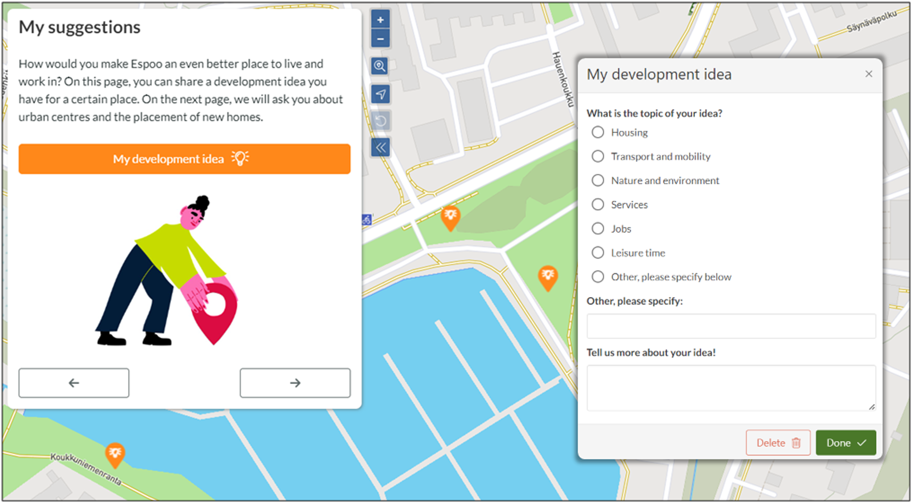
Data analysis
The aim of the analysis was to provide an empirical perspective on the interactions between the diverse spaces of participation introduced in the previous section. Since our primary data was collected using digital participatory mapping tools, we do not explicitly investigate how different spaces for participation influence participatory processes. Instead, we focused on assessing the spatial relationships between the spaces of participants and the spaces in focus of participation.
Focusing on the spaces of participants, two data sources were employed. First, we examined the distances between respondents’ residential locations and the development ideas they had suggested to assess the influence of the residential context on participation interest. All distances were calculated as network distances following the shortest available path. Second, we provided an alternative conceptualization of the spaces of participants based not only on the residential location, but on the respondents’ individual activity spaces capturing the areas they visit most frequently in their day-to-day lives (Schönfelder and Axhausen, 2003). Here, we examined the extent to which respondent-mapped development ideas were located within the boundaries of the individuals’ activity spaces. Activity spaces around the respondent homes were modeled using respondent-mapped activity points. Following the procedure described by Hasanzadeh et al. (2017), 5,013 meters was identified as an optimal cut-off distance for including activity points in the model. This model was supplemented by a measure of activity space centricity (Hasanzadeh, 2019) that employs a spatial clustering approach to identify secondary activity clusters. Here, we used a 500-m radius around the identified secondary activity clusters as a proxy for their area. Thus, in this study, activity spaces were modeled to include also frequently visited sites further from the residential location (see Appendix A for a schematic view). Development ideas located within these areas were identified as ideas within individual activity spaces.
Exploring the spaces in focus of participation, we examined how the spatial distribution of the respondent-mapped development ideas differed between ideas suggested in different categories (transport and mobility, nature and environment, etc.). Moreover, we studied the spatial overlaps between the development ideas and the current planning and development areas of the City of Espoo. These included active detail planning areas and areas identified as future development areas at the time of the data collection (City of Espoo, 2021; Appendix B).
The relationships between variables were assessed with Chi-square tests for categorical variables and nonparametric Kruskal–Wallis H and Mann–Whitney U tests for continuous variables. IBM Statistics SPSS v28 was used for the statistical analysis. All spatial analyses were conducted with ArcGIS Pro 2.5.
Results
Descriptive statistics of study participants.
aPopulation aged 15 years or more (educational level 15–64 years).
bIncluding categories “female” and “other.”
cIn-person or online participation, e.g., participation in events, workshops, or surveys, contact with planners, filed an official notification or complaint, activities in resident or political organizations).

Location of the study area and the distribution of respondent home locations and respondent-mapped development ideas.
Relationships between the spaces of participants and the spaces in focus of participation
Descriptive statistics of respondent-mapped development ideas.
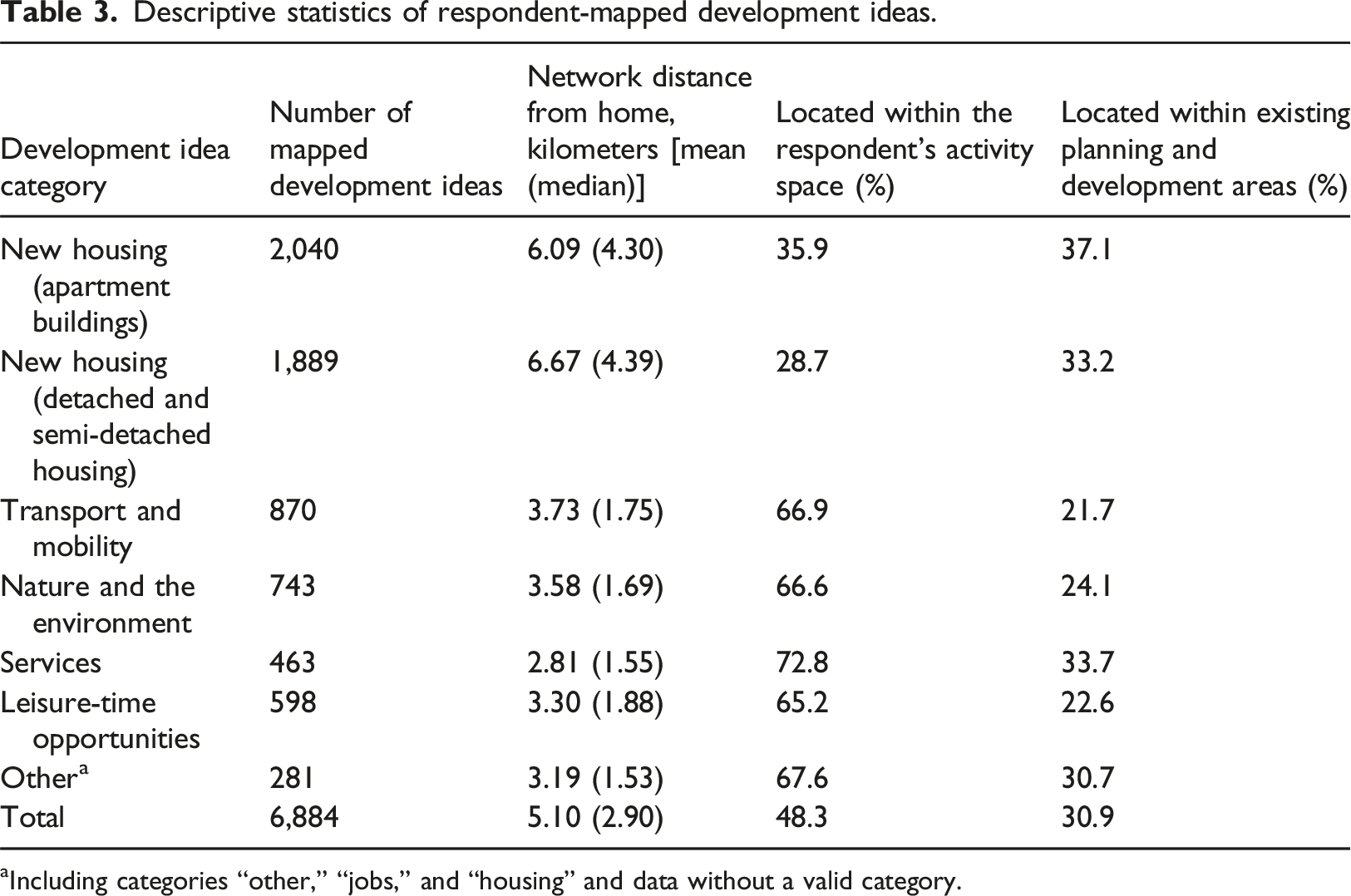
aIncluding categories “other,” “jobs,” and “housing” and data without a valid category.
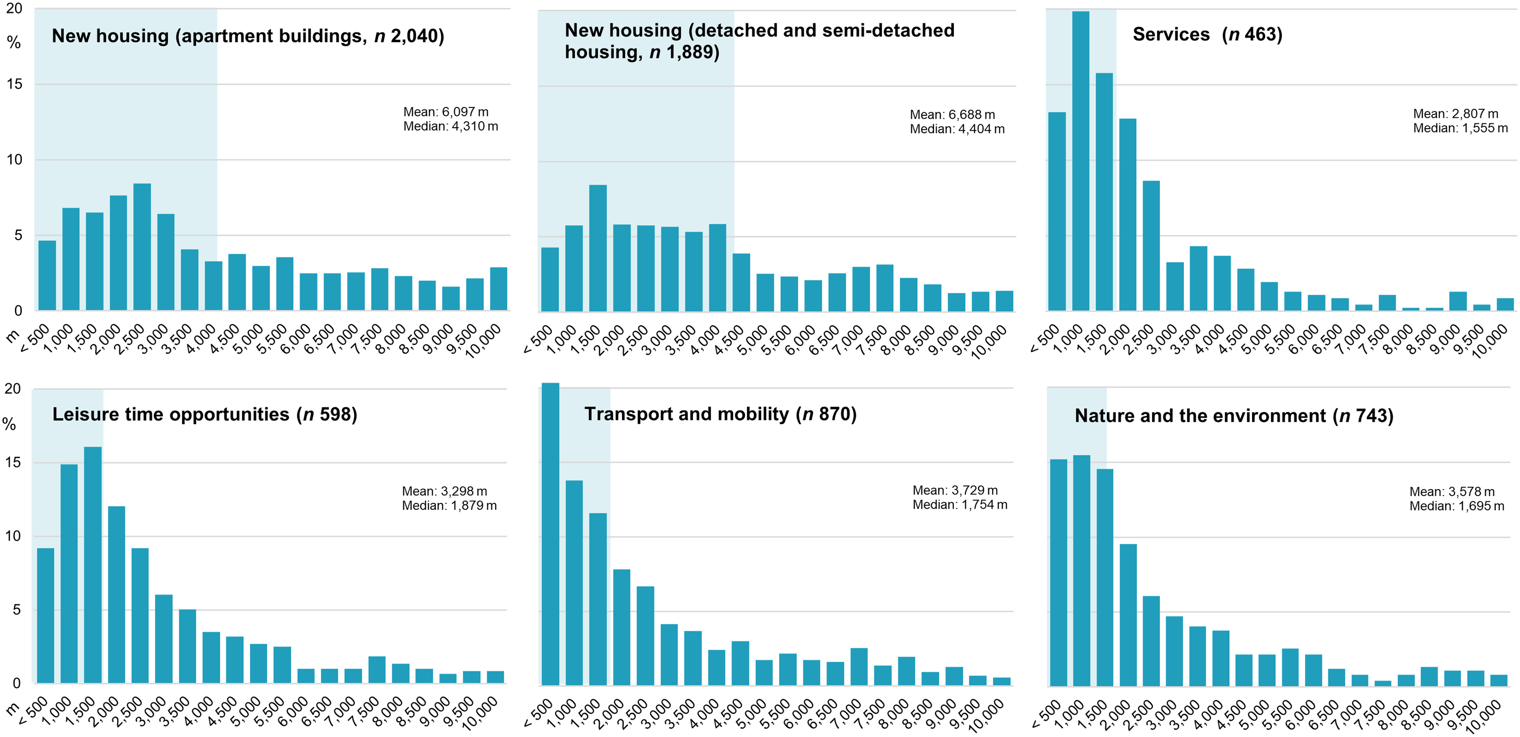
Network distances (m) from respondent homes to respondent-mapped features by category. The highlighted box marks the median value (i.e., distance including 50% of the mapped features).
Overall, 48% of all mapped development ideas were located within the respondents’ own activity spaces (Table 2). However, these shares varied significantly by the category of the development idea (χ2 = 879.6, p < .001). Only 36% of locations for new apartment buildings and 29% of locations for new detached and semi-detached housing were located within the respondents’ activity spaces, while the shares of development ideas located within these areas exceeded 65% in all other categories. The share of development ideas that the respondents had mapped within their own activity spaces also varied significantly by the age group (H (3) = 11.6, p = .009), as participants aged 15–24 years mapped a significantly (p < .05) lower share of their development ideas within their activity spaces than respondents in all other age categories. Female respondents mapped a significantly higher share of development ideas within their activity spaces than males (U = 309,258.0, p < .001). This share differed also by the level of education (H (2) = 12.5, p = .002), with the share of development ideas mapped within the own activity space being the highest for respondents with tertiary education.
Relationships among the spaces in focus of participation
Overall, 31% of respondent-mapped development ideas were located within the existing planning and development areas and active detail planning areas of the City of Espoo (Table 3). However, the shares of points located within these areas varied significantly between the types of development ideas (χ2 = 113.50, p < .001). Suggested locations for new apartment buildings (37%), new detached and semi-detached housing (33%), and development ideas related to services (34%) were most often situated within existing planning areas. The share of development ideas that the respondents had mapped within the existing planning areas did not differ significantly by demographic or socio-economic background but shared a connection with the respondent’s previous experience in participatory planning processes. Respondents with previous experience in participatory planning (online or face-to-face participation) mapped a significantly higher share of their development ideas within these areas than those without such prior experience (U = 328,397.5, p = .028) (Table 2).
Discussion
In contrast to many traditional forms of participatory urban planning that require onsite participation, e-participation presents arenas for citizen engagement that do not require the participant’s physical presence. Multiple studies have discussed the benefits and challenges of digital participation, emphasizing, for instance, the effectiveness of digital technologies in public engagement (Afzalan and Muller, 2018; Ertiö, 2015), the impact of digital participation platforms in motivating or participation (Ertiö et al., 2016; Falco and Kleinhans, 2018; Pantić et al., 2021), and the influence of the participation mode on citizen agency in agenda-setting (Nummi et al., 2023; Pantić et al., 2021). This study adds to this literature by examining the geographies of digital participatory planning from the perspective of the spatial relationships between the involved citizens and the physical environments that are the subject of their participation.
Geographies of citizens’ engagement in digital participatory planning
The influence of e-participation on the spatial aspects of participation has previously been studied by Jankowski et al. (2019), who observed that digital participatory processes attracted participation from a larger geographic area than onsite events. They also concluded that regardless of the mode of participation, local-level planning issues tend to attract proportionally more interest in the local population. Consistent with these results and in line with studies on the relationship between place attachment and community participation (Anton and Lawrence, 2014; Hesari et al., 2020), our findings indicate that the participant’s residential location plays an important role even in digital participatory planning processes that extend beyond the local level. Notably, without any explicit instructions to do so, the participants in this study located nearly 40% of ideas for the future development of their home municipality within two kilometers of their own residential locations. Ideas concerning the availability of diverse services and the maintenance and improvement of public spaces, in particular, were actively suggested in close proximity to respondent homes. By contrast, the participants tended to locate more intensive urban development, such as new housing, further from their homes than development ideas related to the existing urban structure. While this observation could be attributed to a scarcity of vacant areas suitable for construction near the respondent homes, it may also suggest a form of NIMBYism toward urban densification and an example of a place-protective behavior. Similar results were reported in a previous PPGIS study conducted by Brown and Glanz (2018), who found that development ideas related to intensive land use changes were suggested further from home than small-scale urban interventions.
However, the results of this study show that the participants have also considerable interest in the planning of a variety of other places beyond the residential context. These findings suggest that, in addition to participation in the immediate home vicinity with presumably high place attachment and potential for place-protective behaviors, the public’s interest to participate in the planning of specific places and areas may also be motivated through looser and more fluid ties to those locations. Such spatial attachments could be formed, for instance, through familiarity or personal history with specific places, or the accidental or planned exposure to them in day-to-day life. In this study, we studied the spatial overlaps between the mapped development ideas and the participants’ personal activity spaces. These areas were found to capture the majority of development ideas in most categories, indicating a clear overlap between participants’ daily mobilities and the spaces in focus of their participation. However, ideas suggested in some categories, such as those related to new housing, were situated more often outside than within the respondent’s own activity space, indicating looser connections with these spaces. These varied overlaps between participants’ day-to-day environments and the development ideas provide support for the recommendation to treat spaces in focus of participation and spaces of the participants as distinct from each other.
Although our study did not focus on the reasons for the participants’ interest in the planning of specific places, we propose that the plurality of the observed spatial connections between people and the spaces in focus of their participation may reflect diverse motivations for participation. In scalar terms, we see parallels between the spatial patterns observed by Donders et al. (2014), who studied motivations to participate in e-planning separating between public, group, and self-interest. Consequently, interest in the planning of the own residential environment could be understood within the frame of self-interest, while interest in the planning of other day-to-day environments and the current, municipal-level planning issues could be motivated by group and public interest, respectively. However, we acknowledge that the reasons people demonstrate interest in the planning of specific sites are likely to be much more complex than this grouping, reflecting individual values, political views, and highly personal relationships between people and places.
Finally, our results suggest that the public’s interest to participate in the development of specific urban areas cannot be understood simply through direct interactions between people and places, but needs to be examined within a wider contextual framework. In our case study, approximately one third of the respondent-mapped development ideas were located within active development and detail planning areas of the City of Espoo, suggesting a clear overlap between the areas the citizens were interested to develop and the pre-existing plans of the planning authorities. This result may also indicate that citizens are well informed about current plans and, through their participation, signal interest toward specific planning issues (Leino and Laine, 2012). This interpretation is supported by the observation that existing planning areas were mapped significantly more often by participants with prior experience in participatory planning processes than those without, a result suggesting that familiarity with the local urban planning practice and, by extension, current plans, may also influence where citizens choose to engage in participatory processes. Such participation may be informed by existing personal connections with the spaces in question or, alternatively, without personal connections by following the local planning discourse. Conversely, the latter option would exemplify a form of participation in which both information about a planning area is acquired and participation inputs are created detached from the physical environment under consideration. Nevertheless, it is evident that in participatory urban planning, citizens’ local knowledge cannot be understood simply in terms of knowledge, values, and preferences concerning the physical, social, and cultural aspects of the environment, but also extending to the political and information environments.
Implications for designing e-participation in urban planning processes
Compared to onsite participation, the proposed benefits of e-participation include the potential to increase the overall number of involved participants, diversify the groups involved in public participation, and extend the geographic scale of participation (Afzalan and Muller, 2018; Jankowski et al., 2019). Moreover, virtual spheres of participation may facilitate deliberation not only on local matters, but also on matters of wider public interest (Mattila and Nummi, 2022). This study adds to this literature by demonstrating that, despite the detachment of e-participation from the physical spaces of participation, diverse spatial relationships between people and places pertain to e-participation processes. Moreover, we suggest that e-participation has not only the potential to expand the geographic extent of participation in terms of the involved public, but also the produced spatial knowledge. Based on the empirical results on the spatial relationships between citizens and their participation inputs, we propose that e-participation has the capability to capture spatial ties between people and places that differ from those typically captured by traditional participation modes of participatory urban planning that attract and are directed to mostly local participants.
The potential of e-participation to facilitate public participation that is not tied to the territorial framework of the planning authority has been previously discussed by Kallio et al. (2015), who suggest that digital participation and civic engagement may bridge the territorially-oriented administrative reality and the lived-in spatial realities of people. Indeed, the participants of this study were interested in the development of diverse spaces and places of their lives. From a strategic planning perspective, participation acknowledging the multilocality of urban life and the diversity of place experiences across various spatial scales and contexts is likely to provide a fuller and, potentially, more useful understanding of urban life than participation that is restricted by the participant’s geographic location. While statutory participatory planning practices may be bound to specific administrative units, informal, strategic, participatory practices can complement these practices by opening the territorial scope of participation to wider audiences. Furthermore, expanding the spatial scope of participation allows for the inclusion of potential future residents and stakeholders (Kahila-Tani et al., 2019; Schmidt-Thomé et al., 2013), whose early involvement can contribute to the realization of planning’s strategic orientation. In such strategic uses, e-participation appears well-suited for involving individuals with diverse spatial ties in participatory urban planning and, in turn, diversifying the citizen knowledge present in planning processes.
Last, studies evaluating the effectiveness of e-participation on planning outcomes emphasize that the successful implementation of e-participation requires active process development in how planning organizations handle diverse and increasing volumes of participation inputs (Akmentina, 2023; Ertiö, 2015; Ramirez Aranda et al., 2023; Wilson et al., 2019). In this regard, the question of how the voices of stakeholders with different spatial ties to the planning context are treated and evaluated in planning practice remains a topic open to inquiry in e-participation studies. Uncertainties in whose voices, in geographic terms, the participation inputs represent may undermine the practitioners trust in the participation inputs and complicate their integration in spatial decision making (Rossi et al., 2024). However, such uncertainties can be actively addressed by gathering information regarding the participants’ connections to the planning areas during the participation processes to an extent that satisfies the knowledge needs of planning practice. Understanding how spatial relations between people and places influence citizens’ participation interest can assist in evaluating the effectiveness of citizen outreach strategies in reaching specific population groups and improving the geographic representativeness of e-participation.
Conclusions
Following the increasing use of digital tools in participatory urban planning, this study has argued for the need to better understand the spatial dynamics involved in digital participatory planning processes. The results of this empirical case study support previous research observing that e-participation has the potential to spatially expand participation processes both in terms of the public they involve and the spatial knowledge they produce. Overall, the results of this study suggest that while the residential environment plays an important role in motivating participation, citizens’ interest in engaging in urban planning is not limited to their immediate home surroundings or the neighborhood level. Instead, based on our results, we propose that different types of connections between people and places encourage distinct and varied forms of participation. Our results also show that online participation may capture spatial relationships between people and places that differ from those of traditional participation modes, ranging from place-protective behaviors close to the residential location to more casual attachments to other spaces and places of day-to-day life or personal or public importance. To structure, examine, and, eventually, understand the plurality of such spatial relationships, this paper has proposed a working concept of spatiality of participation that separates between the spaces in which participation occurs (spaces for participation), the spatial realities of the participants (spaces of participants), and the spaces as objects of participatory planning (spaces in focus of participation).
Supplemental Material
Supplemental Material - Beyond the backyard: Unraveling the geographies of citizens’ engagement in digital participatory planning
Supplemental Material for Beyond the backyard: Unraveling the geographies of citizens’ engagement in digital participatory planning by Anna Kajosaari, Martina Schorn, Kamyar Hasanzadeh, Tiina Rinne, Saana Rossi, and Marketta Kyttä in Environment and Planning B: Urban Analytics and City Science.
Footnotes
Author contributions
AK: Writing—original draft, conceptualization, formal analysis, and visualization. MS: Writing—original draft and conceptualization. KH: Writing—review and editing and formal analysis. TR: Writing—original draft, conceptualization, and funding acquisition. SR: Writing—original draft and conceptualization. MK: Writing—original draft, conceptualization, supervision, project administration, and funding acquisition.
Declaration of conflicting interests
The author(s) declared no potential conflicts of interest with respect to the research, authorship, and/or publication of this article.
Funding
The author(s) disclosed receipt of the following financial support for the research, authorship, and/or publication of this article: This research was funded by NordForsk, Sustainable Urban Development and Smart Cities Programme, Project Smart Planning for Healthy and Green and Nordic Cities – NORDGREEN, under Grant Number: 95322.
Data availability statement
The full datasets analyzed during the study and containing information on respondent residential location are not publicly available to protect data privacy. Parts of the data are available upon reasonable request.
Supplemental Material
Supplemental material for this article is available online.
References
Supplementary Material
Please find the following supplemental material available below.
For Open Access articles published under a Creative Commons License, all supplemental material carries the same license as the article it is associated with.
For non-Open Access articles published, all supplemental material carries a non-exclusive license, and permission requests for re-use of supplemental material or any part of supplemental material shall be sent directly to the copyright owner as specified in the copyright notice associated with the article.