
Abstract
Palestinian architecture students tell a story of dwelling in the future. In the process of creating their designs to reconstruct paused lifeworlds, they show just how little bifurcation there is between past and present. In this article, I introduce the dwelling-to-(re)build perspective, which reflects a unique reality of displacement and dispossession: the spaces Indigenous communities map and dwell is not confined to this moment. For these students and this project of village reconstruction, dwelling space is not only a momentary expression of houses and lands emptied in a distant past, but a vision of rebuilding and reviving those spaces and the interactions that once filled them. These village designs, the conversations involved in producing them, and their presentation to the Palestinian community is not an abstract exercise. They are cartographic practices that insist on a decolonial future, re-dotting the map not with historic places but with future histories.
Introduction
Nostalgia and imagining the future are often seen as dichotomously opposed temporalities and spaces. However, with indigenous struggle, engaging in critical acts of remembering becomes an inextricable part of both imagining a future and working to realize it. Today, the perspective in critical cartography of acknowledging maps as biased or tools of power, as images that are neither value-free nor simply accurate or inaccurate, is – for most – an analytic given. The more recent focus in the field on indigenous countermapping takes this one step further, highlighting the significant role of mapping as an imaginative, generative practice as well.
From the growth of online databases and recording oral histories to land reclamation and reconstruction-redesign initiatives, there are concerted efforts by indigenous people throughout the world not only to imagine decolonized futures but to impose blended images of yesterday and tomorrow onto the conversations of today. The imposition of this blending is not a rhetorical or abstract endeavor. Understanding that indigenous resurgence is not about a return to the past but a way to escape the rigidity of the colonial present (Coulthard, 2014: 157), 1 I argue that countermapping by way of imagining future spatial expression is both a form of resurgence and a challenge to the narrative of linear settler time. In this article, I provide a snapshot from a larger comparative study. Zooming in on a portion of the Palestinian case, I explore how countermapping by documentation and design can become a decolonial praxis for those who engage in it.
The Palestine Land Society’s (PLS) Village Reconstruction competition, which began in 2017, charges young Palestinian architecture students with reconstructing and designing the destroyed villages of 1948. As an initiative, it builds on the organization’s and Salman Abu Sitta’s (2016) decades-long work to archive, publish, and reframe mostly British mappings – taking a step now toward reviving pre-Nakba spaces. As a large majority of the hundreds of destroyed villages were never built over by Israeli settlers, PLS is also challenging the Israeli argument of unavailable space for refugee return. This current project is the fruit not only of the documentation in the Atlas of Palestine and more recent historical work on the Palestine Exploration Fund, but a larger project at PLS to engage in the material possibilities of refugee return.
Examining this competition, I use what Denis Cosgrove (2008) calls the two directions of study in critical cartography – the finished map and mapping process – to ask how the initiative straddles objectives of historic preservation and imagining entirely new futures.
Blending visual analysis with ethnographic interviews, the narratives and analysis that follow offer a striking example of indigenous resistance across space and time. The practice of designing and planning reconstruction for depopulated and destroyed Palestinian villages across the Israeli settler landscape complicates the production of space as it relates to proximity of inhabitants as well as temporality. The competition and its participants couple that resurgent escape of the entrenched present with J. Brian Harley’s call to use maps as gateways and mediations, bringing to life a spatial expression for what Leanne Betasamosake Simpson (2017: 247) aspirationally describes as a moment in which “the past and future collaps[e] in on the present.”
For the Palestinian experience – like so many Indigenous ones – time is always collapsing in on itself. Sumoud 2 is not linear; it cannot be traced in an order of events marked past, present, and future. Rather, it is made up of limitless temporalities and lived daily across a vast expanse of spaces. In other words, collective memory, current moment, and collective future imagining are joint and immediate, not opposed and distant. Against the progressive narrative of linear time, spectacles of terror rupture pasts as present to return Palestinians to their inaugural moment of loss and reinscribe the terms of their alienation from each other, their land, and themselves. Where dispossession is ongoing, linear narratives elide elders’ legacy and children’s potential (Joudah et al., 2021).
Until now, mapping “dwelling space” as a “momentary expression…produced in relation and through interaction” has been largely discussed and utilized for existing residential land and shifting paths of plant gathering at rural sites (Roth, 2009). However, I am proposing that the concept lends itself particularly well to countermapping efforts by indigenous communities who work to both remember pasts and imagine futures. In the PLS competition, the Palestinian participants’ and their village designs take the concept of dwelling space into the future, in a literal sense. In this instance, mapping both past and future dwelling space is a momentary expression of indigenous resurgence both politically and materially. The submissions are deeply considerate of topographical elements, neighboring populations, and economic conditions of return. Unlike many who write on the practice of countermapping or participatory mapping, my goal is not to provide a roadmap on how to conduct such work, but instead examine how the work being done by indigenous communities themselves moves beyond abstraction.
I seek to answer: In redesigning a destroyed village from scratch, what are the students’ motivations and priorities? How does affirming a particular past spatial presence also challenge the idea of settler permanence? And most importantly, in what ways do these designs highlight a praxis and vision beyond the confines of the competition and the limitations of the present?
The Reconstruction Competition
As native Hawaiian geographer Oliviera reminds us places, like people, have genealogies; knowing a place is intimately related to reciting its stories. In the last 30 years, hundreds of elder Palestinian Nakba survivors have written village histories for a large portion of the towns destroyed in 1948 (Davis, 2010). The books vary in structure but generally contain similar themes. For example, all the histories contain a map of some form and one or more family trees. With the current competition, students are given historical data, hand drawn maps from living Nakba survivors (some taken from these village histories, others solicited by PLS), British Mandate surveys, current Google satellite imagery, and demographics of the residents and descendants.
Currently, eight universities are participating (five in Palestine, two in Jordan, and one in Lebanon); this expanded to include Palestinians in the U.S. and Europe in 2020. University students majoring in architecture and urban planning redesign these villages on the same village site but with updated services using data on projected population. Submissions include the design for rebuilding the village today, as well as a written component which considers historical characteristics of the location.
Using my access to the maps, reports, and data provided by PLS to participants, as well as their final submission, I analyze what past and present information is incorporated and prioritized in these future designs. Additionally, I incorporate over a dozen individual interviews and three focus groups related to the competition and related projects. These semi-structured interviews focus on students’ decision and motivation to participate, design considerations, and their understanding of the competition’s purpose and usefulness (or lack thereof) to the larger struggle for refugee right of return. I also interviewed PLS-partnered faculty at the participating universities, who recruit participants and serve as advisors.
In 7 years of conversation, the most repeated statement by Abu Sitta is “I am not a geographer. I am not an oral historian. I am a refugee trying to regain what he lost.” He explains that “documenting is a thing of the past…. This is about a return plan…about using the past to create a future.” With almost 10,000 files of archival material, PLS has robust folders on approximately 480 destroyed Palestinian villages.” Abu Sitta continued, “the competition follows naturally from the process of documentation…. We asked ourselves ‘what do we do with all of these village files? We must make them usable’ and we ended up here.” 3
PLS has set certain parameters for the participants: villages must be located on original site/lands; any remaining landmarks must be preserved; and they are to incorporate as much data from files provided and independent research as possible. Otherwise, students are free to explore and interpret as they see fit, and the competition judging guidelines have given them a free pass on having to address issues of Israeli infrastructure (road systems and utilities). There is a noticeable lack of cities in the competition; Abu Sitta accounts for this partly as a strategic decision given the narrative being countered on available space and partly due to a vision in which lively cities will be connected to rural livelihoods. The jury for the competition has implored Abu Sitta to consider expanding participation to non-Palestinians, but PLS has remained insistent on preserving this aspect of Palestinian production.
Common Features
Though designs have varied greatly in several ways over the past 5 years, most of the over 150 submissions have a series of common key features: public squares, museums, an attempt to address new road systems, use of oral histories (from independent research), and use of Google satellite images. Perhaps the most interesting commonality however is an almost across the board presence of “guest houses” or “reunion hostels” for refugees or Palestinians in diaspora who choose not to return permanently but would need housing when visiting. Almost all the students’ choices of which village to reconstruct had to do with them being drawn to an aspect of its story. Surprisingly, none of the winners I interviewed from the last 3 years selected a village near their own. (If refugees themselves, often their own villages were not an option. PLS offers files on 50–100 villages to choose from, rotating options annually).
Abu Sitta’s guiding ethic that “you document the past for a purpose, not for a museum,” that “you document to know what you lost, and therefore, to find ways to recover it” reverberates through the designs and the written narratives submitted by the students. Time and again, participants insisted that for them this project was different; it was not yet another cultural endeavor or remembrance of the Nakba. Rather, these young Palestinian architects and urban planners see their participation as a collective move in looking towards the material possibilities of liberation.
Dwelling-to-(Re)Build
“In one minute, the whole life of a house ends. The house murdered is also mass murder, even if vacant of its residents. It is a mass grave for the basic elements needed to construct a building for meaning, or for an insignificant poem in a time of war. The house, murdered, is the amputation of things from their relations and from the names of emotions, and it is tragedy’s need to guide eloquence to contemplate the life of a thing. In each thing there’s a being that aches . . . the memory of fingers, of a scent, of an image. And houses get murdered just as their residents get murdered. And as the memory of things get murdered—wood, stone, glass, iron, cement—they all scatter in fragments like beings. And cotton, silk, linen, notepads, books, all are torn like words whose owners were not given time to speak. And the plates, spoons, toys, records, faucets, pipes, door handles, and the fridge, the washer, the vases, jars of olives and pickles, and canned foods, all break as their owners broke. And the two whites, salt and sugar, are pulverized, and also the spices, the matchboxes, the pills and oral contraceptives, elixirs, garlic braids, onions, tomatoes, dried okra, rice and lentils, as happens with the residents. And the lease contract, the marriage and birth certificates, the utility bills, identity cards, passports, love letters, all torn to shreds like the hearts of their owners. And the pictures fly, the toothbrushes, hair combs, make-up accessories, shoes, underwear, sheets, towels, like family secrets hung in public, in ruin. All these things are the memories of people who were emptied of things, and the memories of things that were emptied of people . . . all end in one minute. Our things die like us, but they don’t get buried with us!” (Darwish, 2006)
Tim Ingold (2000) – from whom Robin Roth (2009), Natchee Blu Barnd (2017), and Mark Rifkin’s work (2017) on dwelling space, indigenous geographies, and settler temporalities all draw – proposes two opposing perspectives that explain why people from different cultural backgrounds perceive the world in different ways. The differentiation between what he calls the dwelling and building perspective rests largely on the creation of meaning through activity versus meaning that has been previously attached. Ingold is quite upfront about the evolution in his own thinking from the building to dwelling perspective, for which he now advocates, and even as he makes the argument to move away from the former, he acknowledges the at-times fruitful role it has played in his field of anthropology. Ingold defines the dwelling perspective as one “that treats the immersion of the organism-person in an environment or lifeworld
4
as an inescapable condition of existence. From this perspective, the world continually comes into being around the inhabitant, and its manifold constituents take on significance through their incorporation into a regular pattern of life activity.” (Ingold, 2000: 154)
Alternatively, in the building perspective – the more widely applied understanding in social and cultural anthropology – people are “understood to inhabit a world – of culture and society – to which form and meaning have already been attached….they must perforce ‘construct’ the world, in consciousness, before they can act in it. (Ingold, 2000: 154)” Ingold goes on to dissect the traditional application of the building perspective and its impact on how we understand dwelling, landscape, and temporality. The architect’s perspective especially, he explains, is “first plan and build the houses, then import the people to occupy them.” Ingold contends that this does not accurately reflect human experiences of people’s relationship to the environment since it is in the process of dwelling that individuals and communities build and it is only in the capability of dwelling that one can build.
If houses are living organisms with life histories and unfolding relations (as some suggest) (Ingold, 2000: 187, citing Blier), then what do we make of houses taken, destroyed, erased? Palestinian poet Mahmoud Darwish gives the resounding answer that it is mass murder, an emptying of memories and memories emptied. This destruction – particularly in the collective form of indigenous spaces – necessitates an expanded and more nuanced understanding of inhabiting, and in turn, what it means to dwell before building. Drawing from Natchee Blu Barnd (2017: 5–6), inhabiting “describes a frame used for establishing belonging or home, a relation to place….sometimes rooted in possession, both of land and of Indianness….to signal differing notions of relationship to land and the related processes of legitimization for bodily presence in specific locations (whether individual or collective).”
At first glance, it could seem that the PLS competition is the quintessential embodiment of the building perspective. However, as one listens to the young architects describe their process, another vision takes shape entirely. These spaces are not empty abstractions to be organized nor are their buildings void of life because the refugees are presently absent. Instead, they are windows to paused lifeworlds, deprived of the daily interactions that come with dwelling but overflowing with collective relations and legitimization. With exile and refugeedom comes the need for these Palestinians to embody dwelling precisely in a manner that supersedes the “mere fact of occupation” (Ingold, 2000: 185) and grounds dwelling in a temporality unconfined by the present.
Here, Mark Rifkin’s “being-in-time” pushes us toward actualizing the need to not only move space out of abstraction, but time as well. More than an inclusion in the present, being-in-time and “Indigenous duration” challenge temporal linearity. Rifkin describes this duration as “operat[ing] less as a chronological sequence than as overlapping networks of affective connection (to persons, nonhuman entities, and place) that orient one’s way of moving through space and time.” Via methods such as storying (and I will add mapping as praxis here), Indigenous peoples reclaim and remake settler colonial violence to a shared language and temporality that allows for futures and possibility.
One of the countless contradictions of colonial modes of domination is the colonizer’s love of archives and “of preserving – not Indigenous peoples themselves, but a record of them (Ghaddar, 2016: 23).” In order to legitimize its present, colonial regimes craft a temporality that limits the past’s relationship to the future. This paradox manifests in the archival realm as meticulous documentation and simultaneous dismissal – confining the past to a moment and insisting on its irrelevance for the future. In the settler colonial context, indigenous communities that actively employ memory to counter claims of settler discovery are accused of refusing to move forward and are re-relegated to the past when addressing present struggles and future potential. However, these settler attempts at controlling temporal application are more than obfuscations of ongoing histories. They are also reflections of distinct experiences of time.
Indigenous duration not only affirms survival, but it also embraces an unconfined temporality. It is a state of living through and in the past and future daily, with every moment inextricable from the other. Just as settler colonialism “destroys to replace” indigenous spaces (Wolfe, 2006: 388), it does the same with producing time. More than historical erasure or extending dispossession to the archive, it refuses the possibility of an indigenous future because it would be forced to reckon with its own failures. The pathological denial here is not without purpose. An essential component to settler colonialism’s logic of elimination and the structured, ongoing nature of settler invasion is destroying any holistic temporality that allows for and works toward indigenous futures.
Part of that colonial love of archive, of preserving a record of Indigenous people is that “the scientific and commercial value of that record resides in the fact that it could never be duplicated.” 5 Indigenous archiving – and in the case of the PLS competition, archives operationalized to build futures – defies this belief. The indigenous labor of building databases of colonial materials and indigenous knowledge while redefining terms, limits, and purposes of that documentation is a direct and targeted challenge to temporal ownership as well as the settler need to entrench the present as a fait accompli. If considering the territoriality of states in historical context is meant to break the binding of the territorial trap (Agnew, 1994), then indigenous activation of pasts as a move toward liberated futures shatters the settler colonial temporal trap.
Palestinians would call this Indigenous duration sumoud. More than mere survival, it embodies connection and an ongoing sense of presence, a steadfastness rooted in moving forward.
The narratives and images that follow exemplify what I am terming a dwelling-to-(re)build perspective. This production of space and of the Palestinians who would inhabit it reflect a reality of displacement and dispossession: the spaces Indigenous communities map and dwell is not confined to this moment. Dwelling space here is not only a momentary expression of houses and lands emptied in a distant past but a vision of rebuilding and reviving those spaces and the interactions and relationships that once filled them.
The Designs: Mapping Dwelling Space
Al-Qastal: Escaping the Present
This first set of images was created by Yazan Nasrallah (University of Petra, Jordan), winner of the Palestine Land Society’s 2018 reconstruction competition. Yazan selected the village of Al-Qastal, outside Jerusalem. Initially overwhelmed by the over 150 village files provided to participants that year, Yazan struggled to select his site. He spent over 10 days opening each village file and exploring British survey mappings, oral history compilations, Google satellite imagery, hand drawn memory maps by Nakba survivors, and data on refugees and projected descendent count. His own family’s village wasn’t among the year’s files and so selection became a process of elimination. He was interested in the Jerusalem area, and as he read, he learned that al-Qastal was of the first villages to be occupied, that it had even been nicknamed muftah al-Quds or the key to Jerusalem (Figure 1). Al-Qastal design submission to PLS, full visual brief.
6
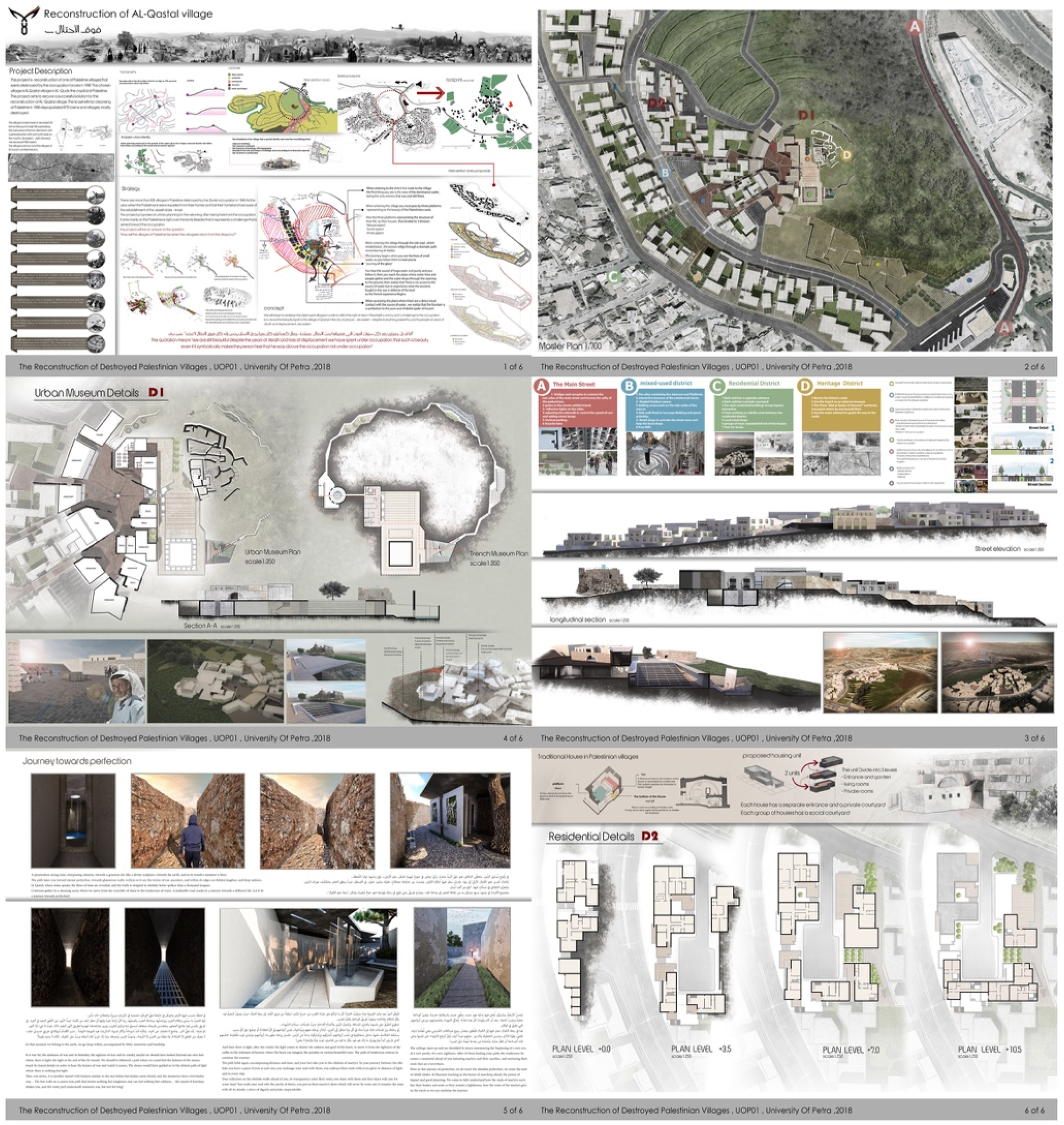
Yazan looked up decisively at me and said “that’s when I knew. If this is where the Zionists started, then this is where we’ll begin return.” For Yazan, the exercise of creating something that imagines freedom, he explained, is not the same as making a video or building a museum. “I was emotionally invested in very different ways,” he recalls. “You start to imagine something that you have regained.” 7
He went on: “It was a small village, but very important because it was on high ground and the Jerusalem-Yaffa road ran through it, and still does. This along with the presence and death of Abdelqader al-Husseini in its battle made the case for me to select it.”
Yazan struggled in the beginning to find the information he needed. He found himself turning to Israeli websites on the garden-park present on the village site today and translating information on the Zionist victory from Hebrew to Arabic. When I asked Yazan how mapping relates to his work, he responded: Mapping is very different. It is important to me to create an experience. For me, maps are more about functionality, roads, etc. Here, functions were of secondary importance. The story and experience were most important to me. There is an emotional experience that I am creating for every individual who comes to the village, which I don’t think is present if you’re just to conduct a mapping. I think more tending to detail, multiple visual perspectives, a lived experience – whether visitor or resident in the village. I think this takes the most time. And we go into architectural detail as a graduation project. The museum and residential area…. The project is more than me making a new plan. It is also a documentation of the past village. Generations come and go. The generation that never lived in Palestine – their knowledge, their familiarity is not like those that lived there. But I can say that I lived in Qastal – for a full year. The duration of the project. Every day, I examined everything in the maps. I learned where every stone lay…as if I lived in the village. If I read a thousand books, it’s impossible for me to have lived in Qastal the way I did during this project. I lived it completely. I imagined how it was in the past, I saw how it is today, and I imagined how it could be in the future. This is, I think, the biggest treasure of the competition.
The most unique aspect of Yazan’s design is what he calls the journey. He creates an imagery upon arriving to the village of seeing nothing but empty land on approach from the Jerusalem-Yaffa road. Yazan wants an immediate emotional response that there is no life here until there is a burst of greenery upon reaching the village entrance, literal return to life. This experience extends into the village square, the museum, agricultural terraces, homes, and so on. Yazan concedes “this experience is not as relevant with time, but more so for a new visitor.” Yazan’s design while full of architectural detail is the creation of an experience above all else.
Towards the end of our conversation, Yazan’s tone shifted slightly, taking a step back and smiling with admiration at the images he was so excited to share, he told me, “Of course, if I was designing this practically for people returning tomorrow, I would have different priorities.” Like so many of the participants, Yazan concedes that in an imminent return scenario, every village planner, architect, and community would need to be in touch with one another. These designs would need to be a conversation and one unit in a master plan, including intensive regional conversations. None of the participants shy away from this practicality. And in the two following design examples, we see varying attempts to account for this.
Ain Ghazal: Collective Revival
The second-place prize in 2019 went to a group of five students (Nour Balshi, Christina Battikha, Careen Matta, Carmen Matta, Elio Mousa)
8
from the American University of Beirut – the first group submission to the competition in its first 3 years. This was also a unique interview process, as I had an opportunity to speak with the AUB students both before and after they had completed their design (Figure 2).
9
Revived spring in reconstructed Ain Ghazal.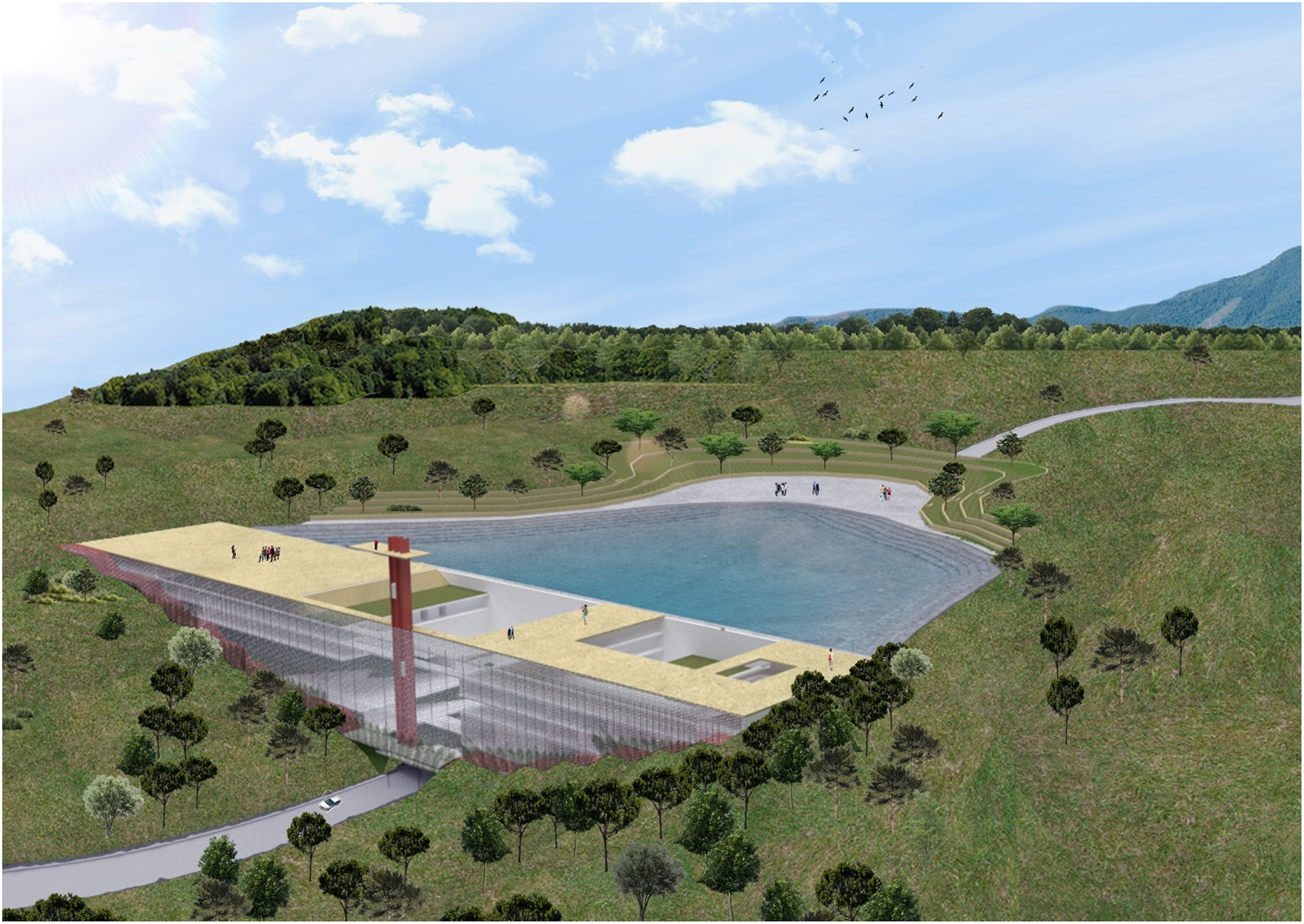
All five of the students were drawn to participate in the competition partly for political reasons or family heritage, but more than anything they were captivated by the idea of challenging themselves to design an emptied space at such a large scale. Until now, projects in their architecture or urban planning courses focused on much smaller scales, but the opportunity to imagine the lifeworld of an entire village was something they simply could not pass up. They told me what makes their design so special is that it is not a reflection of one perspective, but five. Part of Abu Sitta’s vision for this competition has been to not only show the physical possibilities of reconstruction, but also strike debate and conversation over what this could look like. To hear these students to talk as a group is perhaps one of the most representative moments of this aspect: “The ethics of group work was very important to us,” they explained. “Not any one of the villagers will have liberated Palestine; that will be the manifestation of an entire nation’s will. We cannot deny the power of working together now or when they return. If each of us had been working alone, we would not have had the conversations we did that led to critical things in the design, like drowning the road.”
This Israeli road cutting through the village’s lands today, is a key component in their design. They decide to literally drown the road and revive the ain, or spring, for which the town was named. The students propose rebuilding Ain Ghazal by reviving its source of life first, “a new spatial interpretation of the ‘ain’,” explaining that it was not only that homes and buildings were destroyed but that the landscape was “disfigured” and that the road now “cut through the fertile terraces which used to bear many fruit and olive trees.” The structure they design (seen in Figure 15) serves as both a housing tower for returning refugees and a functional reservoir to collect rainwater, reconnect the landscape, and act as a “bridge” between “the past of the village and its future.” 10
In their second interview, having completed the design and waiting for competition results, they were eager to show me what they had accomplished. Six months earlier, they had practically no specific design vision to share, but were intrigued by participation. Now, they were jumping out of their seats to describe and point to image details. “As you’re driving through the main road, the first thing you’re going to see is our project, which is intended to be the gate of the village. When you look inside, you see a big void. From this void, you see the whole project up to the last floor, which is the saha [town square]. As you go through, you’re going to see a welcoming façade that actually draws you inside of the project. This façade is made out of a mesh that helps plants grow on it so that it becomes more organic and vernacular so that the plants are brought back to life by the water itself. The whole project becomes alive and you can see the life through the façade. It’s mostly transparent, and actually blends in with its natural surroundings.” “As a whole, the project is condensed into one singular structure that is retaining all the water behind; we are binding the village together, bringing old inhabitants together with the market, not in the very traditional way that a village is spread out into the landscape. But rather, we condense the village to this wall to retain and create this body of water that is going to revive Ain Ghazal.”
The AUB group did something in their village mapping (Figure 3) that no one else has to date. Essentially, they did not detail a layout of homes and facilities. As the most collaborative of the submissions – not just with each other but with the future residents of their village, the students believed strongly that the Palestinians returning needed to have a voice in rebuilding their homes and what that would look like in the long run. Therefore, the structure and village vision they submitted centered organic growth post-return. “I think had we planned the village, it would have been very ironic, because it would have looked like an Israeli settlement. That is also a main motive because we do not want the people of Ain Ghazal to be forced to live in a way that doesn’t look like them. They will have been immigrants in other places and have adopted new ways of living. But when they come back to Ain Ghazal, they are not going to just lose themselves because they have come back to their motherland.” “We felt the best we could do is empower the villagers and with our architecture, give them tools to feel secure and more empowered to face past or present oppression.” “Ain Ghazal in the old days was a result of years and years and centuries of natural growth and expansion, and that’s how we believe a village should grow. So, we wanted to give the people of the village the option to do that.” From Ain Ghazal design brief, detailing of the façade wall and drowning of the Israeli road.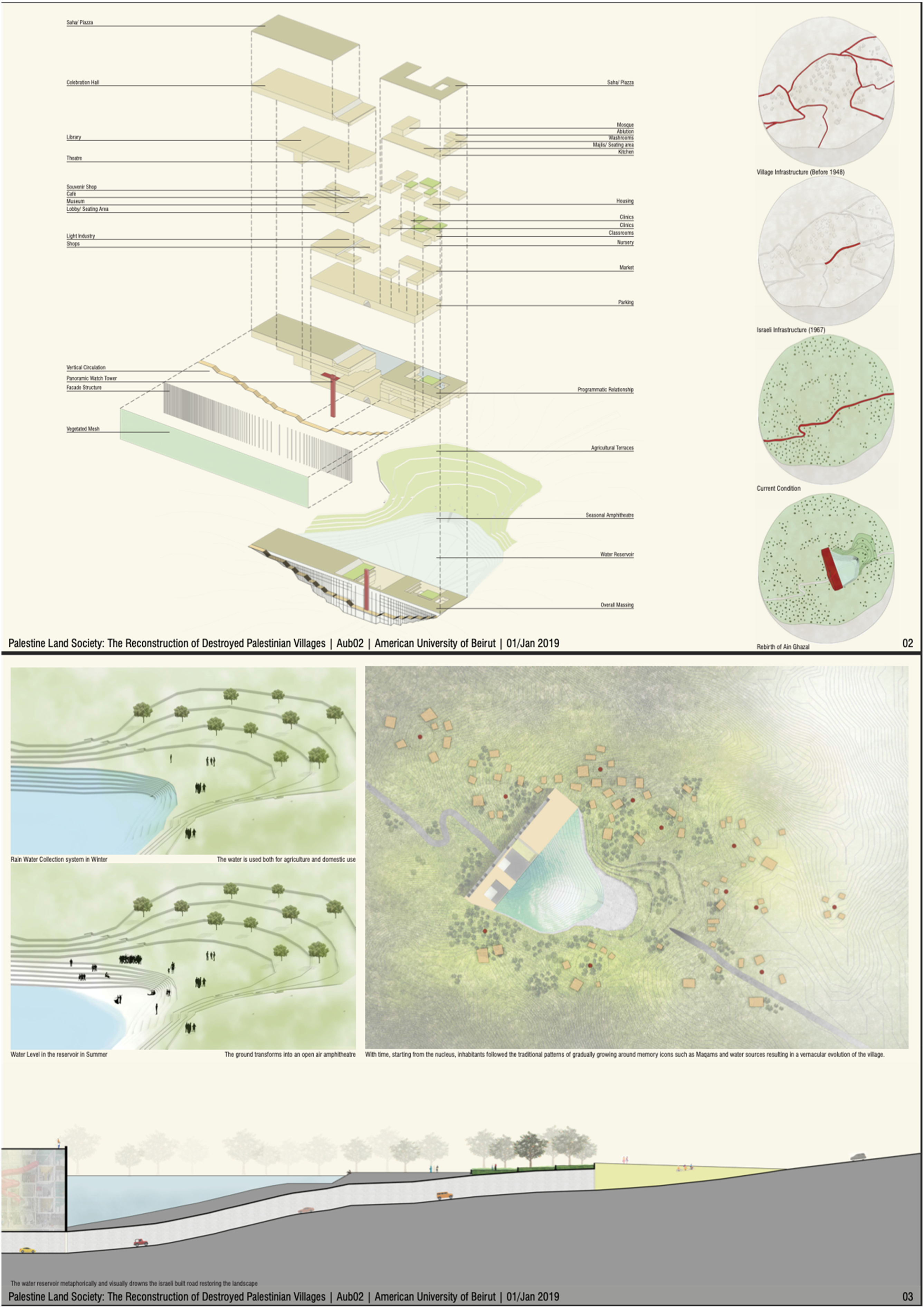
Beit Jibrin: Reimagining Relations
This sketch (Figure 4) of Beit Jibrin, designed by Loay Dieck at Birzeit University received the 2018 third-place prize. In many ways, Loay’s explanation on a conceptual approach to village design is the most integrative of surrounding areas. He admits pretty quickly that he does not presume to know how this should play out but insists that every reconstruction needs to also be a revitalization of relationships. From Beit Jibrin design brief, sketch reconfiguring relations with neighboring villages and areas.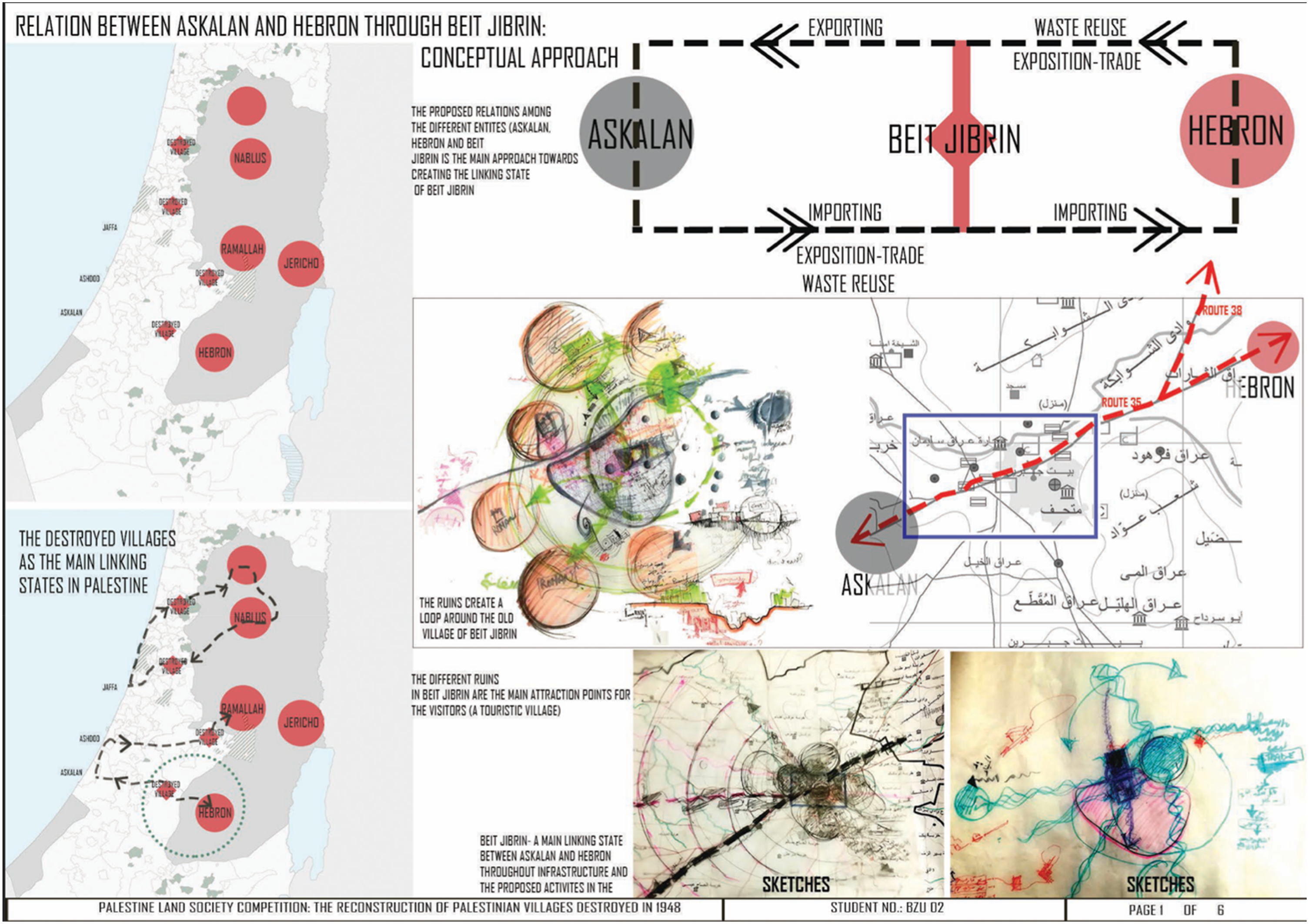
“The historical role of a village economically and its relationship to surrounding towns and cities was important to me,” he explained. “How can we revive not just villages but these relations and district spaces? The connector between two places or two cities is not just a road but the lives of people in those villages and in those spaces in between them.” 11
Here Loay’s “potential solution” in a decolonized future is not only to revive connection, but to use the destroyed villages as an opportunity to “confront fragmentation” and “relink the already fragmented enclaves of the West Bank.” 12 Instead of restoring them under their pre-1948 districts, he proposes that these villages be considered independent entities so as not to enlarge the current “enclaves” (e.g., Beit Jibrin’s inclusion in the Hebron district). Loay clarified that he does not intend to add yet another fragmented entity, but that these independent spaces could be situated as ones that link the “previous West Bank” to a dwelling space in another “previously occupied part of Palestine.” The link is based in infrastructure and activities, with potential in the case of Beit Jibrin to serve as a transit stop between a major economic hub and a coastal city. “Beit Jibrin would be a place to market the products of both cities through different expositions and daily markets and warehouses in the village.” 13 Loay further extends the function of these linking entities to advancing sustainability, pitching the village site as an ideal location for a power plant that doubles for solid waste disposal/reuse “bond[ing] the entities together rather than leav[ing] each city/district to act on its own.”
Other Designs/Evolution of Competition
The three designs above provide selesct snapshots of the innovation and resurgent practice seen throughout the Reconstruction Competition. Even with submissions for the same village site, inspirations for the designs vary greatly. For example, Meral Tabakhna, the third year’s commendation recipient, also selected Ain Ghazal, but did not include water sources as the defining element. Instead, “Ayn Ghazal 2050…was inspired by the experience of the indigenous Zapatistas and the philosophy of ‘walking and learning’.” 14 Meral grapples with the difficult economic realities of transitioning from refugee camp spaces to open land and includes redefining roles of production as her most substantial component. Additionally, because she was based at Birzeit University, unlike the group from AUB, she had access to the refugees and their descendants in the Nur Shams camp and met with community members to get input. Similarly, two submissions for the reconstruction of Tantura set distinct priorities: re-using current Israeli structures and building over (while not destroying) pre-1948 remains. The design puts the new homes at higher elevation, almost stilted above the remains, to give residents a view of the Mediterranean Sea. Other designs envision developing a “green corridor” from the north of Palestine to the south in big picture views while also accounting for community parking so as not to overcrowd neighborhood streets. In the fifth, and most recent year, of the competition, the third-place submission included an “architecture of memory” and a full page of memory matrices to accompany the design.
Over the years, the PLS reconstruction competition has grown both in number and form of participation. What started largely as an annual collection of individual submissions has evolved into an overwhelming percentage of group designs. Most notably, the last 2 years have included calls and presentations to refugee communities of the villages, a sort of report back event between students and the refugees. As these have increased, so have design submissions that include interviews and input from refugees for the reconstruction plans.
Conclusion
From the moment these young Palestinians engage the PLS competition, they are simultaneously looking back to the past and forward to the future. Their participation, their designs, their lives do not hold these temporalities in separate realms. Yazan’s selection of Al Qastal in the present is wrapped up not only in historic loss but also revival. The process he describes is not about designing buildings and planning roads but a lived experience in a place and time beyond his physical limitation. For the AUB group, their work brings to life incredible creativity through collaboration and a hope that the lifeworld of Ain Ghazal will evolve on its own, guided by its residents, with their design serving as a home base. The use of water to both drown and provide new life exemplifies the principle of indigenous resurgence as a way to escape the rigidity of the colonial present. Their experiences challenge the notion that it is only in the process of physically dwelling that individuals and communities build futures and spaces. The individual village designs are reflections of the paused lifeworld of Palestine as a whole.
Loay’s “linking entities” for Beit Jibrin take the dwelling-to-(re)build perspective one step further as he considers the potential for an entirely new set of inter-village relations in a liberated nation. His conceptualization of new paths and roles between villages offers an additional expansion of Ingold’s dwelling perspective. For Ingold, the world is not “everywhere-as-space” but “everywhere-as-region;” here, he defines region as a matrix of movement and places as nodes in that matrix. In other words, “everywhere” is perceived through paths of movement and “places do not have locations but histories.”
Palestine, alternatively, is perceived in terms of interruption – interrupted physically via blocked paths to other Palestinian locales and people and interrupted temporally via stolen futures. In the Palestinian experience, exile and diaspora serve as an expansion of the networks and movements that make up the region. Similarly, the PLS competition and the students’ designs are a reclamation of paths and movement denied.
With over 500 villages destroyed and depopulated in 1948, the revival of these spaces is central to Palestinian notions of return and a Palestinian map that reflects the population of which it was emptied. These designs, the conversations involved in producing them, and their presentation to the Palestinian community is not an abstract exercise. They are cartographic practices that insist on a decolonial future, re-dotting the map not with historic places but with future ones. As Palestine and Palestinians wade through new forms of unthinkable devastation and think through “reconstruction” as more than the clearing of rubble and pouring of foundation, a sumoud of unbound time continue to guide the path forward.
Footnotes
Declaration of conflicting interests
The author(s) declared no potential conflicts of interest with respect to the research, authorship, and/or publication of this article.
Funding
The author(s) received no financial support for the research, authorship, and/or publication of this article.