
Abstract
The space syntax approach has been widely used to investigate the impact of spatial configuration on land use and pedestrian movement patterns. Previous research shows that streets with high accessibility are decisive in the location of common functions and pedestrian movement intensities. This study investigates the factors that influence the movement patterns of first-time touristic users. Iznik was chosen as the research area because of its historical buildings from different civilizations, such as the Roman Theater, Hagia Sophia Church, and Nilüfer Hatun Imaret, and its high tourist value due to the fact that the first ecumenical council took place here. Within the scope of the study, the effects of form and function on users’ experiences were investigated by using space syntax and behavioral mapping methods together. The findings show that functions suitable for common use are located on streets with high integration values, but space syntax parameters are not the primary determinant in forming movement schemes. Distinctive functions and historical buildings were practical in determining the movement patterns of users experiencing the city for the first time. The most significant correlation with human movements was calculated in the global choice value among the space syntax parameters.
Plain Language Summary
This study explores how the design and function of streets and buildings in the historic city of Iznik influence the movement patterns of tourists visiting for the first time. Iznik, a city rich in history with landmarks from Roman, Byzantine, and Ottoman times, was selected for its cultural significance and attractions like the Roman Theater and Hagia Sophia Church. Researchers used a technique called space syntax, alongside behavioral mapping, to study how first-time visitors navigate the city. They found that tourists are more likely to move along streets that are well-integrated and have higher accessibility, which also often contain common public functions or significant historical landmarks. Unique sites and picturesque views had a strong impact on how these tourists explored the city. The findings suggest that enhancing and promoting various tourist routes that showcase Iznik’s diverse history can increase visitor interest and encourage repeated visits. Additionally, this research can help urban planners and local authorities improve infrastructure and promote lesser-known areas, supporting Iznik’s potential for tourism and economic development. Looking forward, using these methods in other historic cities can provide broader insights into enhancing urban environments while preserving cultural heritage, ensuring cities remain vibrant and appealing to visitors and residents alike.
Introduction
Combining physical elements such as streets, buildings, and parks and non-physical elements such as history, culture, and socio-economics shapes cities. The physical elements that form the urban fabric also have an impact on urban identity. Urban identity is defined as the characteristics that are unique to a city and contribute to its transformation, as well as the elements that distinguish a city from others (Lynch & Rodwin, 1958). Hillier (2007) defines the space or form that creates urban identity as a configuration. Configuration is defined as the morphological structure formed as a result of the effect of all the elements that constitute the system on each other. In a point change in the configuration, the whole formation changes. Different cultures have different configuration structures. The local network in the background is often shaped by the way different cultures influence urban space (van Nes & Yamu, 2021). The configuration, including streets, squares, parks, and other public spaces, represents the spatial structure through which ideas and information are exchanged in daily communication (Gehl & Svarre, 2013; Huang, 2006; Kratochvíl, 2013). Street networks, as the essential component of a settlement or configuration, greatly influence the dynamics of urban use (Alexander, 1965; Lynch, 1981). Various quantitative studies have shown that street networks impact people’s experience of the city (Hillier, 2007; Hillier & Vaughan, 2007). Street networks affect the flow of people and the location of commercial units. Streets and roads with a high degree of accessibility are effective in the positioning of commercial units (Chiu et al., 2021; Colaço & dE Abreu e Silva, 2023; Mahmoud & Omar, 2015; van Nes, 2021; F. Wang et al., 2014). People move more on streets with high accessibility. This leads to increased commercial units in places with heavy human traffic. As a result, streets with many commercial units attract more people and stimulate economic activities in that area (Hajrasouliha & Yin, 2015; Hillier, 1996; Hillier et al., 1993; Y. O. Kim, 1999; Li et al., 2016; van Nes & Yamu, 2021; L. Yang et al., 2024). There are several studies showing that human mobility in historic districts is in line with function and spatial configuration (Li et al., 2016; L. Yang et al., 2024). However, there are also studies showing that tourist movements in historic cities do not directly parallel spatial configuration and function (Mansouri & Ujang, 2017; C. Yang & Qian, 2023). Tourists tend to prefer areas with convenient transportation facilities as well as remarkable landscapes and historical sites (R. Liu & Wong, 2019). In the existing literature, while examining the factors affecting pedestrian movement in historic urban spaces, holistic studies that consider both spatial layout (configuration) and functional characteristics together are very limited. This lack of research shows that it is still an important issue to investigate the impact of different functions on tourist movements in historic cities. Nowadays, computational methods have made it possible to measure the physical characteristics of urban forms and to present these data in numerical values and understandable graphics.
Iznik (Nicaea), which contains the historical structures and cultural traces of different civilizations, was chosen as the research area in the study. Iznik, which was the Seljuk, Byzantine, and Ottoman capital, has carried these civilizations’ cultural and architectural richness to the present day. The gridal plan of Iznik, which was examined within the scope of the study, reflects the Hellenistic urban fabric, hosted two great councils that pioneered important turning points for Christianity, and its multi-layered cultural landscape were effective in Iznik’s inclusion in the UNESCO World Cultural Heritage Tentative List in 2014. Although existing studies (Altun, 1998; KırlıÖzer, 2020; KırlıÖzer & Çahantimur, 2022) have addressed the physical structure of Iznik, the structure of its spatial configuration and its impact on human movement have not yet been examined with quantitative methods.
The discipline of urban morphology emerged in the early 1960s to analyze urban form and its changes. Urban morphology analysis deals with the structure or urban fabric of a city. In this way, a city’s formation and transformation processes, historical development, and constituent components can be analyzed (Conzen, 1960). Studies on urban morphology analyze the evolution of a city since its foundation by identifying various components (Moudon, 1997). Lynch (1960) and Alexander (1964, 1965) laid the foundations for using mathematical data to analyze urban morphology. While analyzing urban fabric-form, this process focuses on urban cognition, such as streets and street networks (Venerandi et al., 2017). Hillier and Hanson (1984) used space syntax, which utilizes the foundations of graph theory, to reveal urban form characteristics with quantitative data. With the space syntax method, socio-spatial analysis of built environments can be performed to investigate the accessibility value of the system and its effect on human interaction. Space syntax theory examines how spaces in systems come together, how people perceive spatial systems at all scales, from small residential areas to large-scale cities, how they move in these spaces, and how they use these spaces (Hillier, 2007; Hillier & Hanson, 1984; Penn et al., 1998). Today, with computational methods, it has become possible to analyze the configuration resulting from the simultaneous presence of physical and non-physical elements, and to express their effects on human movement flow patterns with quantitative data and graphics.
The space syntax method is widely used in current studies to reveal the accessibility potential and socio-spatial dynamics of historic urban areas (Li et al., 2016; Şahin Körmeçli, 2024; Yücekaya & Günaydın, 2020; Zheng et al., 2024). In addition to the space syntax method, a second method can provide more meaningful data on physical structure and human behavior (van Nes & Yamu, 2021). In historical urban areas, in integration with the space syntax method, Points of Interest (POI; C. Yang & Qian, 2023; Zhang et al., 2024), Geographic Information System (GIS; Li et al., 2016; C. Yang & Qian, 2023), cognitive maps (Celik & Yildirim, 2025; Y. O. Kim & Penn, 2004), gate count (Maniei et al., 2024), place-based behavioral mapping (Magdy et al., 2024; Y. Wang & Chen, 2024) have been utilized. Qualitative data can be transformed into meaningful quantitative data. Scatter plots constitute a suitable infrastructure for this transformation (van Nes & Yamu, 2021). Unlike other studies, this study uses the data obtained from the person-centered behavioral mapping method together with the axial line technique, which is among the space syntax analysis techniques. The pedestrian movement data obtained from the person-centered behavioral mapping method is named as usage count and associated with axial lines automatically generated by DepthMapX. In addition, correlations were made between the choice or integration parameters and the usage count parameter using scatter plots.
The research focuses on the question, “How do Iznik’s multi-layered historical fabric and historical structures affect the pedestrian movement patterns of tourists visiting the city for the first time? To what extent is the relationship between spatial configuration (form) and functional points of attraction (function) decisive in explaining this mobility?.” This study examines the impact of Iznik’s multilayered historical fabric on tourist movements through space syntax and person-centered behavioral mapping. The study investigates how differentiated functions such as the Roman Theater, Hagia Sophia Church, Nilüfer Hatun Imaret and city walls affect the movement patterns of first-time visitors to the city. Although there are studies in the literature that examine the relationship between spatial structure and human behavior in historical cities, there are limited studies that analyze this relationship with quantitative methods in a city like Iznik, which bears the traces of different civilizations. The study aims to reveal the effect of both spatial form and functional points of attraction on tourist movements by combining axial line analysis and person-centered behavioral mapping. Thus, it is intended to provide a data-based infrastructure that will contribute to Iznik’s UNESCO process. In addition, the use of the two methods mentioned above in an integrated methodology with scatter plots constitutes one of the unique features of the study.
The study aimed to achieve the following objectives:
Revealing the formation structure of the historical city of Iznik with quantitative data
Revealing the relationship of spatial configuration with function and physical elements
Revealing the impact of function and historical buildings on the movement flow chart of the user who does not know the city
Presenting a quantitative study to guide future interventions planned for the city
The study utilized the space syntax method and its parameters to reveal the structure of Iznik’s formation and socio-spatial relations. The person-centered behavioral mapping method was preferred to reveal human movement flows. The results obtained were expressed with quantitative data and evaluated comparatively. The use of these two methods together in a historical city is important in terms of revealing the effect of the elements that constitute the city on human behavior. The results obtained within the scope of the study help us understand the dynamics of historical cities and provide important information that can guide future interventions. Figure 1 shows the framework of the study.

Framework diagram.
Literature Review
Spatial Configuration-Function and Movement Relationship
Spatial configuration, the geometric result of urban form, affects the behavior and movement scheme of the user who experiences the form. Many studies show that spatial configuration impacts user activities (Chang & Penn, 1998; Gehl & Svarre, 2013; Hillier et al., 1993; Lynch, 1981; Penn et al., 1998). Studies show that the geometric shape of cities directs human behavior and movement patterns. Every journey in the city takes place along the preferred axial lines between the origin and destination (Hillier & Iida, 2005). The space syntax approach reduces the properties of spaces to axial and convex maps. In this approach, people walk along axial lines, gather in convex spaces, and perceive the urban environment through fields of vision (Karimi, 2012). The axial line analysis technique is a common approach to analyzing an urban form (Hillier, 2007; Lee et al., 2023). Axial lines are the first task to be performed in order to analyze the topological accessibility of an urban fabric (Oliveira, 2013). Even small changes in morphological structures change the configuration of the system, that is, the axial line map. Road widths and road lengths affect the length of the axial line. Of two road fabrics of the same length, the wider road will have a longer axis line than the narrower road (van Nes & Yamu, 2021). As a result of a change in the road fabric, the structure of the whole formation and, therefore, the urban experience of the user changes.
Hillier (1999) revealed the mutual influence of configuration on movement and land use preferences. Well-defined spatial factors are shown to play a decisive role in the development and growth of cities. H. K. Kim and Sohn (2002) in a study conducted in two different districts of Seoul, found that the location of office buildings and the intensity of land use are parallel to the spatial configuration parameters and that spatial configuration impacts function. The structure of the street and road network affects movement. Shops are on streets where people move (Hillier et al., 1993). Chiu et al. (2021) analyzed the morphological change and functional change in Taipei cities since 1895 to investigate the impact of urban regeneration on function. Their results showed that common urban functions and commercial units are located in more accessible parts of the city. van Nes (2021) and Colaço et al. (2023) showed that shop owners look for the most suitable location to reach more customers; the change of road fabric in cities has changed the location of stores. Stores are located at highly accessible points and relocated in line with urban changes. This is supported by studies investigating the compatibility between urban form and function (Chang & Penn, 1998; Hillier et al., 1993; Penn et al., 1998). Residential areas are generally located in areas with low accessibility (Hillier, 2007). Xu et al. (2019) found that low-income users live in more segregated city areas. Studies on configuration have revealed that the density of users experiencing urban space is in line with accessibility parameters (El-Darwish, 2022; Hacar et al., 2020; Ozbil et al., 2018; Yaylali-Yildiz et al., 2022). Studies have shown that urban form significantly impacts land use and human movements.
Linking Human Activities to the Space Syntax Method With Empirical Data
While urban forms are designed and produced within a specific plan, urban planners and designers carry out urban interventions by focusing on past experiences and knowledge from precedents. However, designers cannot offer a definitive solution on creating well-functioning built environments (van Nes & Yamu, 2021). When the structure behind the configuration that expresses the interaction between space and society is understood, the effects of interventions following consistent rules become generally predictable. Studies in this field reveal the possible effects of interventions in configuration on human behavior (Hillier, 2002, 2007; Peponis, 2016; van Nes, 2011). In addition to the space syntax method to reveal human behavior in physical space, a second method to be included in the research allows for more realistic data on physical structure and human behavior. Quantitative and qualitative data can be associated with the results of space syntax. Qualitative data has the potential to be transformed into meaningful quantitative data. Scatter plots provide a suitable infrastructure for linking qualitative data with place sequence results (van Nes & Yamu, 2021). Gate count method is a widely used for observing the intensity of pedestrian and vehicular movement flows in an urban setting. The number of pedestrians and vehicles crossing the imaginary line chosen for observation is noted and compared with space syntax parameters (Al_Sayed et al., 2014). This method is used to show that streets with high accessibility have high human movement flow rates and streets with low accessibility have low human movement flow rates (Abu Elkhair et al., 2023; Garip et al., 2015; Hacar et al., 2020; Hillier & Iida, 2005; Penn et al., 1998). Maniei et al. (2024) revealed that pedestrian behavior in the historical areas of Isfahan city is influenced by socio-economic functions and landmarks using space syntax and gate count methods. Mansouri and Ujang (2017) investigated the determined factors of tourist movement patterns in the historic district of Kuala Lumpur. They concluded that land uses in the area are more effective than spatial configuration. The gate count method’s advantage is that it directly correlates with space syntax parameters. Studies using survey data to reveal the structure of spatial configuration (El-Darwish, 2022; Liu et al., 2018; Yaylali-Yildiz et al., 2022) have shown that the user uses spaces with high accessibility more often than experiencing physical space. In the cognitive mapping method, individuals’ spatial perceptions are represented through drawing or marking. In research conducted by Y. O. Kim and Penn (2004), it was observed that the cognitive maps created by the participants were compatible with the accessibility values in the city. Celik and Yildirim (2025) revealed the differences in the experience of local users and visitors in Eskişehir Odunpazarı urban landmark. They show that local users use shortcuts by utilizing built-in information, while visitors rely on prominent landmarks for wayfinding. Place-centered behavioral mapping is an alternative method to detect human behavior in urban space. Gümüş and Yılmaz (2022) compared the behavior of users in a city square with space syntax parameters. Ozbil et al. (2018) revealed the structure of the configuration by using behavioral mapping and questionnaires together with space syntax parameters. Wang and Chen (2024) investigated the behavior of elderly users in an urban park area using spatial sequencing and behavioral mapping. The findings show that shading and the degree of accessibility are decisive in the behavior of the elderly. The disadvantage of place-centered behavioral mapping and survey methods was observed as the inability of the data to establish a direct relationship with the space syntax parameters. The researcher’s inference shapes the data obtained through these methods. One alternative method to reveal the relationship between human movement flow and spatial configuration is movement traces. In this method, the movement traces of the selected user in the urban space are drawn on the map and compared with the spatial configuration parameters(Al_Sayed et al., 2014). C. Yang and Qian (2023) used space syntax and POI data to show that the main determinant of tourist movements is differentiated functions. Zhang et al. (2024) used a combination of POI data and space syntax method and found that scenic areas are dominant in tourists’ movement preferences. Within the scope of this study, the person-centered behavioral mapping method and space syntax parameters are used together to reveal the factors affecting the movement of the user experiencing the city for the first time.
Case Area: Historical Iznik City
Iznik is an ancient city located within the borders of Bursa province in Turkey. It has been home to many civilizations throughout history due to its strategic location, and today, it carries the traces of these civilizations in its modern texture. It has been the center of various cultures and belief systems throughout its long history, from the Hellenistic period to the Republican period. During the Roman, Byzantine, and Ottoman Empires, the city assumed the role of capital. It was of great importance militarily and religiously, and with the Seljuk rule, it became an important center of art.
It is known that Iznik is located in the south of the Marmara Region, 85 km from Bursa, on the eastern shore of Lake Iznik. It is physically connected to the Lefke Strait and Sakarya Valley to the east, Lake Iznik-Karsak Suyu Valley, and Gemlik Bay to the west. The Samanlı Mountains surround İznik to the north and the Katırlı Mountains to the south. Iznik is located 85 m above sea level, and its surface area is 753 km (Akbulak, 2006). While agriculture, especially olive cultivation, is the cornerstone of the city’s economy, grape growing has also played an important role in the past. Annual rainfall can reach 528 mm east and 775 mm West (Meşeli, 2010). While the temperatures are milder in the plains around the lake, the temperature decreases in higher areas.
The topographic structure of Iznik is characterized by the surrounding Lake Askania (Iznik). With its fertile alluvial soils and sheltered location around the lake, İznik has historically offered a favorable area for agriculture and trade. The presence of the lake has enabled the city to develop as an important port and trade center since ancient times (Eyice, 1988). Iznik was built on a flat area without a significant slope, which allowed the city to develop a grid plan, making it highly accessible. This arrangement also made it possible for Iznik to be a legible city (Wycherley, 1993). This grid plan, which reflects the Hellenistic urban texture, facilitated the understanding of the spatial organization of the city (Altun, 1998; KırlıÖzer, 2020; KırlıÖzer & Çahantimur, 2022).
During the Hellenistic period, Iznik, located on the eastern shore of Lake Askania on the borders of Mysia and Phygia, was initially known as Antigoneia. The city was rebuilt by Lysimachos, one of Alexander the Great’s generals, and named “Nikaia” in honor of his wife (Şahin, 1987). Strabo, who visited the city in 18 BC, stated that the city had four gates and that the roads cut each other vertically (Pekman, 2005). The inner walls built during the Hellenistic period are evidence of the city’s regular planning. The city’s location in the interior of the Bithynia region also made it possible for it to function as a strategic defense area. Strabo states that the natural elements around the city influence city planning and defense systems (Pekman, 2005). n addition, the city’s grid plan and street layout provided spatial legibility by increasing human mobility and accessibility (Conzen, 1960; Lynch, 1960).
During the Roman period, Nicaea became an important center of the province of Bithynia. However, the city’s importance relatively decreased after Nicomedia was declared the capital. Nevertheless, with the support of Emperor Hadrian, Nicaea was rebuilt after the earthquake in 120 (Şahin, 1987). The theater, Lefke Gate, and other monumental buildings from the Roman period show the city has a rich Roman heritage. When analyzed using the spatial arrangement method, it is seen that the structural arrangements in the Roman period increased social interaction and commercial mobility (Hillier & Hanson, 1984).
During the Byzantine period, Iznik hosted two ecumenical councils of great importance for Christianity. Held in 325, the First Council of Nicaea is considered the first general council in the history of Christianity (Yalduz, 2003). he Seventh Council held in 787 in Hagia Sophia was an important turning point in decisions against iconoclasm (Altun, 1998).
During the Seljuk period, the city was captured by the Turks after the 1,071 Malazgirt Victory and became the first capital of the Seljuk State under the name “Iznik” (Demirkent, 2004). The Seljuk period is important in the artistic and architectural development of Iznik.
The Ottomans annexed Iznik in 1,331 and built mosques, madrasas, and other structures emphasizing the Islamic identity in the city. Iznik developed as an Ottoman center of science and art during this period. However, from the 17th century onward, the decline of tile-making and epidemics reduced the city’s importance (Angold, 2004).
After the proclamation of the Republic, Iznik remained a small settlement center for a long time. However, with the revival of tourism since the 1980s, the city regained its importance. In 2014, Iznik was included in the UNESCO World Heritage Tentative List. Iznik’s tile production and multi-layered historical texture have made the city an internationally recognized cultural heritage (UNESCO, 2014).
Iznik is a city that has hosted the traces of different cultures throughout its history, from its foundation in the Hellenistic period to the present day. While this rich historical heritage sheds light on the city’s past, it also reveals its cultural and touristic importance today. The city walls form a physical boundary surrounding the city, while the monumental structures within the walls (such as the Hagia Sophia Church, the Ancient Roman Theater, Nilüfer Hatun Imaret) and the lake to the west constitute a center of attraction. Especially the limited permeability of the city wall gates and the scattered positioning of historical buildings within the city wall are determinant in the spatial perception of visitors. Today, Iznik has achieved an urban structure in which historical buildings and new buildings are intertwined within the city walls, while outside the city walls, the grid plan has been disrupted. This multifaceted morphology also embodies the city’s “historic urban landscape” value in the UNESCO World Heritage nomination process. Iznik’s multi-layered structure makes the city an ideal case study for comparatively examining the impact of spatial configuration and cultural heritage on tourist behavior. Figure 2 shows the existing site plan of the city of Iznik.

The existing site plan of Iznik.
Methodology
Space Syntax
Space syntax is a method of analysis introduced by Hillier and Hanson (1984) to examine the effect of the formal structure of space on how people use space. In spatial organization, the simultaneous relationship between the parts constituting the whole is defined as configuration. As a result of the geometric layout of cities, each city has a unique configuration. This means that the whole formed by the units that constitute the cities constitutes the configuration (Hillier, 2007). Axial lines are the first task to be performed in order to analyze the topological accessibility of a spatial configuration (Oliveira, 2013). An axial line is defined as a line of sight that contains motion logic. To create an axial map, roads, streets, and spaces that allow movement are modeled using axial lines (van Nes & Yamu, 2021). A study by Lee et al. (2023) showed that most current space syntax research is at the urban scale, and the most commonly used analysis technique is axial line analysis. After the representation of the spatial form with axial line maps is created, two features are analyzed. The first is accessibility (to-movement, integration), and the second is the movement potential of units (through-movement, choice; Hillier, 2007; Hillier & Iida, 2005). Hillier et al. (2012) argue that journeys involve two essential elements. These are choosing a destination from a starting point (integration) and choosing a route with places to pass between the starting point and the destination (choice).
To understand the structure of a configuration, it is necessary to understand both local (R3) and global (Rn) spatial properties. While the local scale reveals the syntactic relationship of an axial line to lines three topological steps away, the global scale reveals the relationship of all lines in the system. Global integration analysis estimates the accessibility value of a street to all other streets in the urban system (Hillier, 2007). Many neighborhoods have their local shopping districts. These areas have a low global integration value but a high local integration value (van Nes & Yamu, 2021). High integration values indicate that the relationship between the axial line and other lines is stronger; in other words, the line is more accessible. The longer the axial line and its connection with other lines, the higher the integration value. Choice is defined as the potential for movement and is used to measure the degree of accessibility. As the length of the journey increases, the movement is expected to reflect the preference structure rather than the integration structure (Hillier & Iida, 2005). High choice values refer to streets likely to be used when traveling from a starting point to a selected destination. Synergy and intelligibility can also be analyzed as an alternative to integration and preference values (Refaat, 2019). With these measures, mathematical properties of places that are difficult to perceive with the naked eye can be expressed.
Synergy value is calculated due to the correlation between global and local integration values (Kostakos, 2010). This measure shows how much the global structure is reflected in the local structure. The intelligibility value is calculated as a result of the correlation between global integration and connectivity measures. Intelligibility refers to the amount of information that a new user can obtain about the whole system from local traces (Hillier et al., 1987). Scatterplots represent intelligibility and synergy values. A value of 0.40 between 0 and 1, represented by R2, indicates a moderate correlation, while a value of .65 or higher indicates a strong correlation (Al_Sayed et al., 2014). Within the scope of the study, synergy and intelligibility parameters were used to reveal the physical structure of the historical city of Iznik, and choice and integration parameters were used to reveal the effect of physical structure on function and human mobility.
Behavioral Mapping
Behavioral mapping is a systematic observation method widely used in environmental and behavioral research. This method aims to record in detail the behaviors and movements of individuals in a given space as they occur (Bechtel et al., 1987). Behavioral maps visualize where individuals are located, what kind of activities they engage in, and the spatial distribution of these behaviors. Sommer and Sommer (2002), describe two main types of behavioral mapping: place-centered and person-centered mapping. Spatial-centered maps are used to document the use of a particular area over a period of time. For example, this approach is suitable for examining what activities a park is used for at different times of the day (Ng, 2016). On the other hand, person-centered mapping focuses on tracking the movements and activities of a person or a group of individuals in different places over time. This type of mapping can be helpful, for example, in understanding the after-school spending habits of young people (Ng, 2016). Behavioral mapping offers significant advantages over data collection methods based on self-report rather than behavioral observation. In self-reporting, individuals may not be able to fully express their daily behaviors or where and how they perform a particular activity due to social desirability concerns. Moreover, routine behaviors may be forgotten over time, or individuals may not be aware of them. Behavioral mapping provides the opportunity to record behaviors objectively in the context in which they occur and to relate observed behaviors to place time, and physical environment (Barker, 1968).
Behavioral mapping is a research approach that is usually carried out with a paper-and-pencil method. In this method, a unique note-taking system is developed for each study and is applied by the researchers in the fieldwork (Sussman, 2016). Ittelson et al. (1970), defined the first step in creating a behavior map as preparing a scaled map of the area to be researched. On this map, an appropriate marking is made each time a specific behavior occurs. Today, this method is evolving from paper and pencil to electronic devices and is becoming more practical with the opportunities offered by technology (Hanington & Martin, 2012). According to Moore and Cosco (2010) behavioral mapping offers a powerful tool for recording the behavior of individuals in specific spaces, and this data can be used to examine the relationship between healthy outdoor design and use. It is an innovative approach to revealing the relationship between the physical characteristics of space and user behavior, especially in places such as schools, neighborhood parks, and public open spaces.
Behavioral mapping is an important method for understanding individuals’ interactions with the environment and designing more effective and sustainable spaces based on this information. The systematic and objective nature of the method makes it possible to analyze the relationships between spatial characteristics, user types, and periods. These features make behavioral mapping widely used in environmental psychology and urban design.
In Iznik, a person-centered behavioral mapping study was conducted to identify the routes used and the buildings experienced by people visiting the city for the first time. This documentation is of great importance for understanding the experience of experiencing a city as a visitor, the use of architectural heritage and movement preferences in an unknown environment. Within the scope of the study, the participants were asked to take a city tour in groups of four for 90 min and to mark the roads they traveled on the maps given to them by the researchers. One of the group members was asked to take videos along the way, another was asked to stop in front of the historical buildings they had identified and take panoramic photographs, and the last participant was asked to take selfies in front of these buildings with all group members. 110 undergraduate architecture students who had not experienced Iznik before volunteered for this task.
Four group members were assigned specific tasks to support the study. The first role, the observer, was responsible for marking the group movements on the map provided; however, the observer was not involved in other monitoring parts of the study. This restriction was implemented to prevent other group members from using the map. The second role, the cameraman, was tasked with time-stamping and documenting the routes used by the group, stopping points and clues used during the study. The third role was assigned to the photographer, who was asked to take panoramic photos every 5 min to document the city from a first-time visitor’s perspective and record the salient focal points. Finally, the self-shooter was tasked with taking photographs of all members in front of historical buildings identified by the group to determine how accurately these buildings were represented in the behavioral maps. At the end of the study, the usage counts of the axial lines were collected in the behavioral maps created by the groups. For each axial line used, a usage number was marked on the axial line map of Iznik.
Groups of four were randomly selected from a pool of pseudonyms categorized by gender and age to ensure equal distribution. All participants were asked to sign a responsibility and acceptance form stating that they volunteered for the study and accepted full responsibility throughout the process. During the data analysis, we first identified the overlapping routes used by tourists as they traveled around the city and the most visited areas of Iznik. Then, the structures marked on the cognitive maps drawn by the participants after the tour were listed and the most remarkable historical structures and archeological remains were identified. With this analysis, the dominant religion and the historical layer of this religion that influences the city’s identity for tourists were revealed. In addition, the religious buildings located in heavily used and less preferred areas of the city and their impact on the city’s image were analyzed. In the final phase, the most iconic historical layers and structures that form the city’s image were detailed, providing a powerful analysis of the city’s identity. The methodological variables used in the study and their definitions are shown in Table 1.
Methodological Variables Used in the Study and Their Description.

Results
In this part of the study, the effect of the spatial configuration and land use status of the historical city of Iznik on movement is investigated. Firstly, the intelligibility and synergy values of the spatial configuration method’s axial line technique were used to reveal the formal characteristics of the city. Then, the relationship between choice, integration parameters, and land use status was investigated. After the form-function relationship of Iznik was revealed, the effect of these relationships on the movement flow diagrams of 14 groups experiencing the city for the first time was revealed. Graphically and numerical results were obtained after the axial maps used for the research were created using the fewest-line technique through DepthmapX software. In the graphs, red and orange colors were used to express high values, and blue colors were used to express low values. In the graphs, the axial lines with the highest value are represented by
Spatial Configuration-Land Use Relationship Results
The spatial configurations of cities result in invisible features to the eye but have a decisive impact on human behavior. Intelligibility indicates the amount of information that a new user can obtain about the entire system from the local structure. The intelligibility value of Iznik city was measured as 0.204 (Figure 3a). The fact that this value is far from the average value of 0.40 (Al_Sayed et al., 2014) shows a hierarchical order in the city’s configuration, with long and high connectivity lines coexisting with short and low connectivity lines. The low value indicates that the user who experiences the city for the first time is unlikely to have an opinion about the whole city. The correlation between global and local integration values shows the synergy value. The synergy value is calculated as 0.735 (Figure 3b), indicating a very high global-local scale fit. The high value indicates that a global structure is formed by repeating the traces of the local structure.

Scatter plots showing intelligibility (a) and synergy (b) results.
The integration and choice values of the axial line analysis not only show the accessibility and choice values of the urban configuration but also provide information about the possible locations of the common-use functions in the city. The accessibility (to-movement, integration) and choice (through-movement) values obtained from Iznik are shown in Table 2. A harmonious distribution is observed between the global and local integration values. The high difference between the maximum and average integration values indicates a foreground structure with high accessibility and a background structure with low accessibility. The difference between the maximum and average values is relatively high for choice values. This indicates the existence of dominant routes that are expected to be used when traveling between two points. The obtained choice and integration values also indicate a hierarchical order in the urban configuration.
Results of the Axial Line Analysis Parameters.
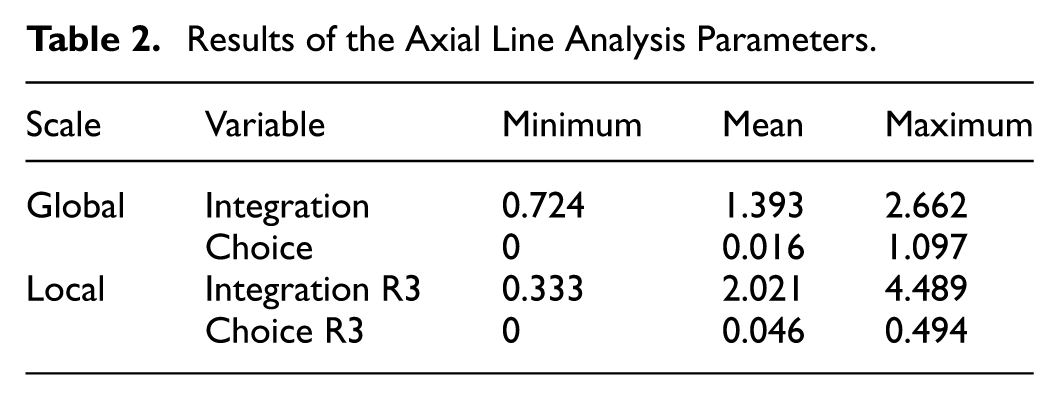
Figure 4 shows the relationship between the land use pattern of the buildings and spatial integration. Shopping areas are located along the most integrated north-south (

Land use relationship of buildings with global (a) and local (b) integration.
Figure 5 shows global (a) and local (b) choice values and land use relationships. At the global scale (Figure 5a), the highest choice value (
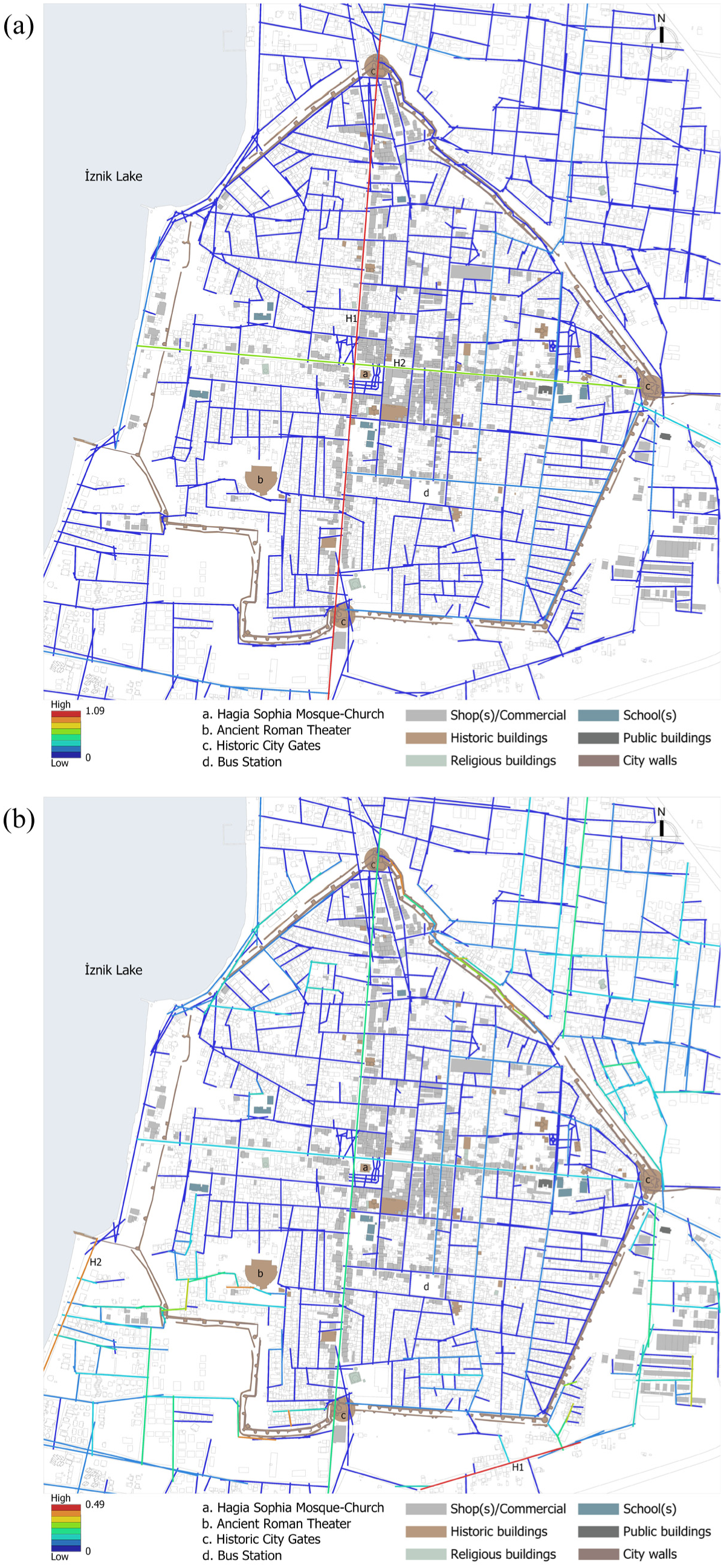
Land use relationship of buildings with global (a) and local (b) choice.
Pedestrian Movement Pattern and Spatial Configuration—Land Use Relationship Results
Figure 6 shows the axial lines and land use of the 14 groups that experienced the city for the first time. The lines located in the north-south and east-west directions (Figure 6

Land use relationship of buildings with usage count.
With 10 uses, the third highest value is located on the shore of Lake Iznik. Although this line has a below-average integration and choice value, it has many uses. This is because this line has a good view of the lake and is close to the ruins of the city walls. With 9 usage count, the fourth highest value was calculated in the section east of the city walls where the historical buildings are located. Although the axial lines in the north of the area have very low integration and choice values, they were included in the routes of users experiencing the city for the first time due to the presence of the city wall and city gates. The other axial lines used by the users who experienced the city within the scope of the study were the lines that accommodate commercial, historical, and religious buildings and provide access to these buildings. Users did not prefer building islands with dense residential areas. The axis north of the city bus station, denoted by
Figure 7 shows the correlation between usage count and the global and local integration and choice values used in the study. The correlation between global integration and usage count is .091, while the correlation between local integration and usage count is .090. The similarity in the local and global scales has maintained its similarity in the movement relationship of the user experiencing the city for the first time. The results obtained are far from the average value of 0.40. This shows that the integration parameter is not the only determinant in pedestrian movements and that the attraction effect of lines with high integration values but without distinctive functions is low. The correlation result between global choice and usage count is .21. Although this value is still lower than the average value of 0.40, it is considerably higher than the integration indicators. This proves that as the length of the journey increases, the movement reflects a preference structure rather than an integration structure (Hillier & Iida, 2005). The correlation result between local choice and usage count is .040. This relatively low value indicates that the local choice value is ineffective in human movements.

Scatter plots showing the correlation of usage count with global integration (a), local integration (b), global choice (c) and local choice (d) values.
Discussion
Historic city centers create an important attraction effect for tourists who experience the city for the first time due to the cultural values they contain. Today, historic buildings in historic city centers, which are transforming to adapt to changing user needs, can be located at points with low accessibility. This situation has led to the need to develop strategic plans for perceiving the physical structure of historic city centers and enriching the experiences of users who experience the city for the first time. Revealing the movement schemes of users who experience the city for the first time for touristic purposes in cities that are transforming to meet the needs of the rapidly increasing local population is important for future interventions. This study investigated the effect of the relationship between spatial form and function on pedestrian movements in the historic city.
In the literature, studies are showing that high values of space syntax parameters are the determining factor in the positioning of commercial functions (Chang & Penn, 1998; Chiu et al., 2021; Colaço & dE Abreu e Silva, 2023; Hillier et al., 1993; H. K. Kim & Sohn, 2002; Ozbil et al., 2011; Penn et al., 1998; van Nes, 2021). The results obtained within the scope of the study show that shops and common functions are distributed in line with the integration parameter of the axial line method, which is parallel to previous studies. In the city of Iznik, which was examined within the scope of the research, functions that people can shop or experience for cultural purposes are located on lines with high integration (accessibility; Figure 4). This shows that spatial configuration has a comprehensive impact on the spatial structure and functions of the city. Space syntax parameters can help predict the potential impacts of urban interventions. In addition to the spatial configuration-function relationship, studies are showing a parallel relationship between space syntax parameters and pedestrian density (Abu Elkhair et al., 2023; Hacar et al., 2020; Maniei et al., 2024; Ozbil et al., 2018; Safari & Moridani, 2017; Sharmin & Kamruzzaman, 2018; L. Yang et al., 2024; Yaylali-Yildiz et al., 2022). The study revealed that users experiencing the historical city of Iznik for touristic purposes did not correlate strongly with the space syntax parameters (Figure 7). In other words, the city’s physical structure was not a determining factor in tourists’ experience of Iznik. The findings statistically showed that the most significant relationship in human movement was established with the global choice value.
The findings show that the distinctive functions in the historic city center are the main determinant in attracting and generating pedestrian flows of users experiencing the city for the first time, as emphasized in previous studies (Mansouri & Ujang, 2017; C. Yang & Qian, 2023; Figure 6). It reveals that the functional points of attraction (Roman Theater, Hagia Sophia Church, city walls) and the lake view are the determinants of the shaping of tourist movements in Iznik, rather than the spatial configuration. The visual and physical boundaries created by the city walls were among the factors that influenced pedestrian movements within the city walls. The findings of the study indicate that each region has unique characteristics and that these characteristics are not suitable for generalization. These results deviate from the accessibility models predicted by traditional space syntax approaches and demonstrate how visual and functional attractors play a critical role in touristic pedestrian movement dynamics in historic cities. The findings open an important discussion on how the configurational effects emphasized in previous studies (Hillier, 2007; Hillier et al., 1993; van Nes & Yamu, 2021) are balanced by qualitative factors such as historical structures and natural focal points. This finding will be an important guide for urban planners and designers for their future interventions in historic city centers. Despite being located in areas with low accessibility, distinctive functions have the potential to attract pedestrians. It is possible to make these points more accessible through interventions in the spatial configuration.
Although the space syntax approach is an important determinant in the form-function balance of the city, the understanding that touristic use differs from the use of the city’s inhabitants has an important impact on future intervention decisions. This study was conducted by a team of 14 groups and all participants were architecture students. The lack of demographic diversity in the sample limits the generalizability of the findings. Including participants of different ages and education levels will make the findings more generalizable for future studies. Within the scope of the research, only the movements of tourists who do not know the city were examined, and the space experiences of local users were not compared with touristic movement patterns. This deficiency prevented the understanding of the differences between touristic and daily use. In addition, the data collection process was limited to a specific time period, which was insufficient to reflect seasonal and daily movement variations. Despite these limitations, the study provides an important basis for understanding the impact of Iznik’s historic fabric on tourist movements and provides a methodological framework for future research. In future research, the methods used in this study (“space syntax” and “person-centered behavioral mapping”) can be applied to historical cities with an organic fabric, as opposed to Iznik’s grid plan, and comparative analyses can be conducted.
Conclusion
Iznik’s multifaceted cultural landscape makes it a unique experimental environment. The rational grid plan of the Hellenistic period and the irregular fabric of the current situation, the conflicts of attraction between historical buildings and the permeability problems created by the city walls directly affect the spatial perception of tourists. This study aims to transform this complexity into quantitative data, not only to fill an academic gap, but also to contribute to the conservation and preservation strategies that Iznik needs in the UNESCO process.
This study investigated the impact of the physical elements of cities and urban identity on the formation of movement flow patterns of users who experience a city for the first time for touristic purposes. The integration and choice parameters of the axial line technique of the space syntax method were used to reveal the relationship between spatial configuration and function, and the person-centered behavioral mapping method was used to reveal the importance of the form and function of the city in determining the movement flows. The parameters of the behavioral mapping method were transformed into quantitative data, and their relationship with the space syntax parameters was investigated. It was shown that high integration values play an important role in the location of common functions. It was also shown that the highest integration and global choice values have a directive effect on human movement flows and that users who experience a hierarchically organized city for the first time use the most dominant axial lines. Other high integration values are not effective enough in forming movement patterns, and differentiated functions and scenery are more effective in the touristic experience.
These findings provide an important basis for future urban interventions to enhance Iznik’s touristic potential. Developing a variety of tourist routes that emphasize the city’s layered historical and cultural richness can encourage repeat visits by highlighting different facets of the city. Thematic or chronological routes focusing on Roman, Byzantine, or Ottoman heritage can allow visitors to experience the city’s historical identity more deeply. In addition, strategic work can be done in the light of these findings for Iznik’s inscription on the UNESCO Permanent Protected List. Data-driven analysis of pedestrian flows and functional distribution can support this process by strengthening the authenticity and integrity of the city.
The findings point to the need for administrative authorities to integrate spatial analysis into urban planning processes to provide access to less-integrated areas and increase the promotion of unique buildings. By providing local governments with actionable information, it may be possible to prioritize interventions that meet local people’s needs and enhance Iznik’s tourism and economic potential.
Future research could aim to obtain generalizable results by applying the methods used in this study in historical cities with high intelligibility values, unlike Iznik. Furthermore, examining the impact of seasonal changes on tourism can contribute to understanding the changes in movement flow patterns over time. Collaboration between urban planners, historians, and tourism experts can ensure that interventions are implemented in a way that preserves cultural heritage and optimizes the usability and attractiveness of the city.
In conclusion, the findings of this study highlight the potential of integrating quantitative and qualitative methods to inform sustainable urban development. The strategic use of space syntax and behavioral mapping methods has shown to be an effective tool for cities like Iznik to preserve the historic fabric and balance it with modern demands.
Footnotes
Acknowledgements
We would like to thank the Bursa Metropolitan Municipality for sharing the current maps of Iznik.
Author Contributions
Conceptualization; BMK, Data curation; BMK, Formal analysis; BMK, Investigation; BMK, GKÖ, Methodology; BMK, GKÖ, Project administration; GKÖ, Resources; BMK, GKÖ, Software; BMK, Supervision; GKÖ, Validation; BMK, GKÖ, Visualization; BMK, Roles/Writing—original draft; BMK, GKÖ, and Writing—review & editing BMK, GKÖ.
Funding
The authors received no financial support for the research, authorship, and/or publication of this article.
Declaration of Conflicting Interests
The authors declared no potential conflicts of interest with respect to the research, authorship, and/or publication of this article.
Declaration of Generative AI in Scientific Writing
No generative AI was used in the scientific paper. Everything in the study was created by the authors.
Data Availability Statement
The data that support the findings of this study are available on request from the author(s).*