
Abstract
Mongolian toponyms encode both natural and human information and serve as key carriers of the grassland cultural landscape. They help align the region’s natural scenery with its cultural value. This study builds a translational logic—symbol decoding—function interpretation—relational analysis—to convert cultural-landscape symbols and functions into spatial value. Grounded in the cultural-landscape framework of symbol–function–power, we recast symbolic “power” as spatial “value,” providing a theoretical basis for the translation path and clarifying the shared attributes of cultural meaning and spatial form. Using Zhengxiangbai Qi, Inner Mongolia as a case, we combine a toponym semantic network with landscape spatial analysis to decode cultural and spatial symbols in Mongolian place-names; we then interpret their functions through their referential, signifying, and simplifying roles. Next, we apply spatial autocorrelation and spatial clustering to resolve the element hierarchy of the cultural landscape, thereby achieving spatial translation, functional regeneration, and the shaping of “power” into “value.” Findings show that: (a) under the core theme of human–nature synergy, the cultural-landscape theory of value generation is supported; and (b) strong links exist between the toponym semantic network and landscape components. The common functional relations shared by cultural and landscape symbols can be turned into a pathway for value mining. The study verifies the applicability of cultural-landscape theory in grassland pastoral contexts and offers differentiated strategies for enhancing the spatial value of rural cultural-landscape resources. It advances a shift from interpretation to practice, supports the sustainable evolution of the human–environment relationship, and provides new ideas for uncovering local cultural value.
Plain Language Summary
Chinese grassland settlements offer rich natural scenery and cultural assets. As a key part of rural cultural landscapes, place names contain untapped cultural value. Landscape elements are dispersed and functionally isolated, so they have not been fully integrated or converted into useful resources. Drawing on cultural landscape theory, this study identifies the cultural symbols in place names and the matching landscape symbols in Inner Mongolia’s grassland herding areas, then examines their roles within the broader cultural landscape. By mapping where these symbols occur and assessing their relationships, we establish a localized translation pathway for cultural landscapes, which supports resource integration and uncovers spatial value. The results reveal a strong association between place-name semantics and nearby landscape elements, showing functional overlap between cultural and landscape symbols. This study also confirms the “value generation” concept of cultural landscape theory and provides practical guidance for the sustainable development of cultural landscape resources in China’s grassland regions.
Keywords
Introduction
Cultural landscapes are complexes of cultural phenomena on the Earth’s surface that reflect a region’s geographical characteristics (X. D. Li, 1984). At its core, the study of cultural landscapes seeks to reveal the theoretical logic behind the “human–environment relationship.” In the early twentieth century, Sauer (1925) proposed that “culture is the driving force in shaping landscapes,” meaning that cultural landscapes are the result of human activities layered on natural landscapes. Its composition includes both the material basis on which landscapes depend for survival and the human/cultural agents that constitute landscapes—the humanistic factors themselves (M. L. Tang & Jin, 1998). With the cultural turn in the social sciences, new perspectives on cultural landscapes emerged in the mid–late 20th century: the landscape came to be treated as a readable “text,” whose meanings are produced through interpretation by subjects, generating symbolic significance and re-creation. North American scholars further proposed that culture is carried by a “symbol–code” system (Baldwin, 2004), shifting attention to immaterial dimensions such as texts, images, symbols, and discourses, which are functional in specific ways. J. B. Jackson and Denis Cosgrove emphasized that landscapes are symbolic systems that carry meaning and possess a narrative function (Cosgrove, 1998; Jackson, 2015). By the 1980s, sociologists and geographers increasingly viewed culture as a concept closely tied to power (Said, 1993), and Barnes and Duncan argued that the landscape is an expression of social power (Duncan, 1990). From an epistemological angle, Chinese scholars have contended that the cultural landscape is a form of social construction—both a product of power relations and productive of power itself (Xiang & Lü, 2010). Accordingly, cultural landscape studies can be distilled into a multidimensional relation of “symbol–function–power,” a view that resonates with systems theory, in which structured elements form an integrated whole to realize specific functions (Yang, 2010). The basic features of systems—holism, structure, hierarchy, and functionality (Sun, 2019)—map onto the associative nature of cultural symbols and the integrity of landscape functions. In current rural construction and development, it is urgent to resolve the dilemmas of “cultural aphasia” (loss of cultural voice) and homogenization (“thousand villages, one face”). The core of cultural landscape theory is to inscribe intangible culture into material space, emphasizing human–nature synergy and, within rural cultural revitalization, advancing an integrated goal of cultural transmission, landscape conservation, and economic development.
The symbol–function–power logic in cultural landscape studies forms an integrated system that nests the systems-theory cognitive frame of elements–structure–function: symbols act as the system’s elements; through particular combinations they form structures that confer functions. On this basis, we parse relations between cultural symbols and landscape symbols and build a translational logic of symbol decoding–function interpretation–relational analysis. At the symbolic level, all human activities can be seen as processes of producing and disseminating signs (Ren, 2024). As a key component of the cultural landscape, toponyms themselves function as symbols that stand in for material spatial entities, cultural beliefs, and affective images (Li, Mi, et al., 2011). In current toponymy research, scholars argue that most Chinese place-names follow a “proper name + generic term” structure, with the proper name locating and the generic term classifying; the former mainly conveys regional and geomorphic type information, while the latter denotes landform attributes (Guo, 2004). Since the 1990s, Chinese studies on Chinese toponyms have adopted computer-assisted quantitative methods to analyze, at a meso scale, the characteristics of toponymic landscapes and their formation mechanisms—moving the field toward greater scientific rigor and systematization (Luan et al., 2021; B. Wang & Huang, 2011; B. Wang & Situ, 2007; B. Wang & Yue, 2007). Research on Mongolian toponyms is relatively sparse; existing work blends linguistics and ethnology with geography to examine natural features, naming principles, spatial distributions, and drivers of change (Qinggele, 2013). Studies that directly target toponym semantics remain few; a small number apply semantic analysis from a cultural-ecology perspective to trace spatiotemporal evolution (J. Zhao et al., 2016). Classic semiotics holds that a sign is a perception that carries meaning, highlighting the material and perceptible nature of signs; accordingly, the landscape itself constitutes a sign. Discussions of spatial landscape elements and their patterns have focused on ecosystem-element analysis (N. X. Wang & Lu, 2015; Xiao, 1999), spatial structure and configuration (Huang et al., 2019), and landscape layout planning (Ding & Han, 2018). Analytical approaches to landscape pattern fall into two broad types: spatial-statistical methods (Lü et al., 2007) and pattern-index methods (Wu, 2004); within the former, spatial autocorrelation is widely used to reveal urban landscape structure and its determinants (Zeng et al., 2000). Current work at the interface of toponyms and landscape either treats the toponymic cultural landscape as an integrated whole—using generic terms to reflect relations between landscape and local culture (H. Y. Li, 2021)—or analyzes links between landscape and toponym semantics and the drivers of toponymic change (Hearn et al., 2024). At the functional layer, information expression and transmission in cultural landscapes take symbols as carriers that describe human thought, history, and culture. Because symbols possess signifying, referential, and simplifying functions, cultural-landscape symbols are themselves functional. At the “power” tier of this semiotic system, recent developments in theory have led Western scholars to foreground its effects on cultural landscapes and social structures, opening new perspectives; Chinese scholarship summarizes this as correspondences between concrete spatial forms and specific values, symbols, and meanings, thereby revealing the spatial morphology of value and discussing the spatial re-presentation of symbolic meaning (X. Tang, 2005). Anchored in the Chinese context, this study translates “power” into the shaping and recognition of regional cultural-landscape “value,” forming a closed loop from identifying system elements, to analyzing functional attributes, to application in practice. It thus builds a stepwise logic of “symbol–function–value.” At the value layer, most research concentrates on cultural-landscape heritage, traditional villages, and scenic areas, and focuses on value cognition, value connotation, and evaluation systems. Regarding value cognition, scholars argue that, from a value perspective, cultural landscapes are characterized by the agency of people, holism, processuality, relationality, and sustainability (J. Han & Wang, 2022). Regarding value connotation, domestic studies summarize cultural-landscape value as historical value, developmental value, spatial-wholeness value, natural value, and associative/spiritual value (Bi & Han, 2017; W.-Y Han et al., 2025). In value evaluation, intrinsic value, historical value, cultural value, and social value constitute the main assessed dimensions, with ecological and economic dimensions increasingly incorporated (H. Xu et al., 2018).
In sum, existing studies have yielded rich findings on the spatial distribution and characteristics of toponymic culture, but most remain qualitative under a cultural background lens and overlook the intrinsic relations between toponymic culture and landscape elements. Methodologically, although GIS-based spatial analysis is widely used, its application patterns tend to be homogeneous and horizontal. Cross-disciplinary attempts exist, yet research on Mongolian toponyms remains limited, with a lack of systematic linkage between toponym semantics and spatial landscape patterns, as well as insufficient robust quantitative methods. Meanwhile, in studies of cultural-landscape value shaping, many results stop at explicating value connotations and proposing strategies; they seldom engage a planning-practice perspective to explore spatial pathways for enhancement and the conservation-and-use of cultural-landscape resources. As a result, the value-application layer remains underdeveloped. Against this backdrop, and grounded in cultural landscape theory, this paper focuses the core scientific question on how to effectively parse and translate the multidimensional relations of “symbol–function–power” and their spatial representation within grassland pastoral cultural landscapes. Using spatial autocorrelation and spatial clustering as methodological mediators, we aim to construct a quantitative linkage between toponymic culture and spatial landscape patterns, thereby overcoming the prevailing split between semantic texts and spatial form. Ultimately, we verify the applicability of cultural landscape theory in grassland pastoral contexts; transform the abstract “power” dimension of the theoretical framework into an operational “value” dimension; and, through quantitative analysis, reveal the re-presentation of toponymic cultural symbols in landscape space and the logic of value bearing. We thereby achieve spatial value mining for cultural landscapes and propose practice-ready, actionable pathways for value shaping and for the conservation and utilization of cultural-landscape resources. These contributions provide quantitative support and scientific evidence for planning implementation and the sustainable development of rural resources, helping to bridge the gap between theory and application.
Data and Methodology
Study Area
The Inner Mongolia Autonomous Region boasts the largest grassland area in China, characterized by vast expanses and a rich diversity of landscape elements—including mountains, forests, fields, rivers, lakes, and grasslands. Unlike other regions in China, its landscape exhibits a high level of heterogeneity: croplands and pastures are intricately interwoven, and three distinct geomorphological bases—forest grassland, typical grassland, and desert grassland—are clearly differentiated, enhancing its unique regional features. With a long historical legacy, Inner Mongolia has served as a vital crossroads for the nomadic, agricultural, and hunting civilizations of China. Its traditional nomadic production mode, marked by a “lifestyle of following water and pasture,” has generated a dynamic cultural landscape, making the region an ideal case for studying human–environment relationships and rural cultural revitalization.
This paper takes Zhengxiangbai Qi in the southwestern Xilingol Grassland as the study area (see Figure 1). Located on the southern margin of the Hunshandake Sandy Land, it exhibits a north–center–south geomorphic gradient—from northern sandy land, through central hilly grassland, to the southern farming zone—and presents a distinctive agro-pastoral mosaic: farming–herding interlacing, a complete suite of landscape elements (mountains, forests, farmland, rivers, lakes, and grasslands), yet with marked fragmentation (see Figure 2). The area harbors a large, relatively well-preserved, and semantically rich system of Mongolian toponyms (see Figure 3), providing an ample and representative basis for in-depth toponym-semantic analysis. Its semi-farming, semi-herding way of life not only generates pronounced heterogeneity in spatial landscape patterns but also yields place-names with mixed Mongolian–Chinese etymologies. Consequently, for revealing the spatial representations of symbol–function–power interactions, the region’s regional landscape character offers a direct geographic substrate. Moreover, being unaffected by commercial tourism development, the study area’s natural environment largely retains its primary state, while cultural and landscape functions continue to follow natural successional dynamics—affording exemplary reference value as a minimally human-disturbed baselines.
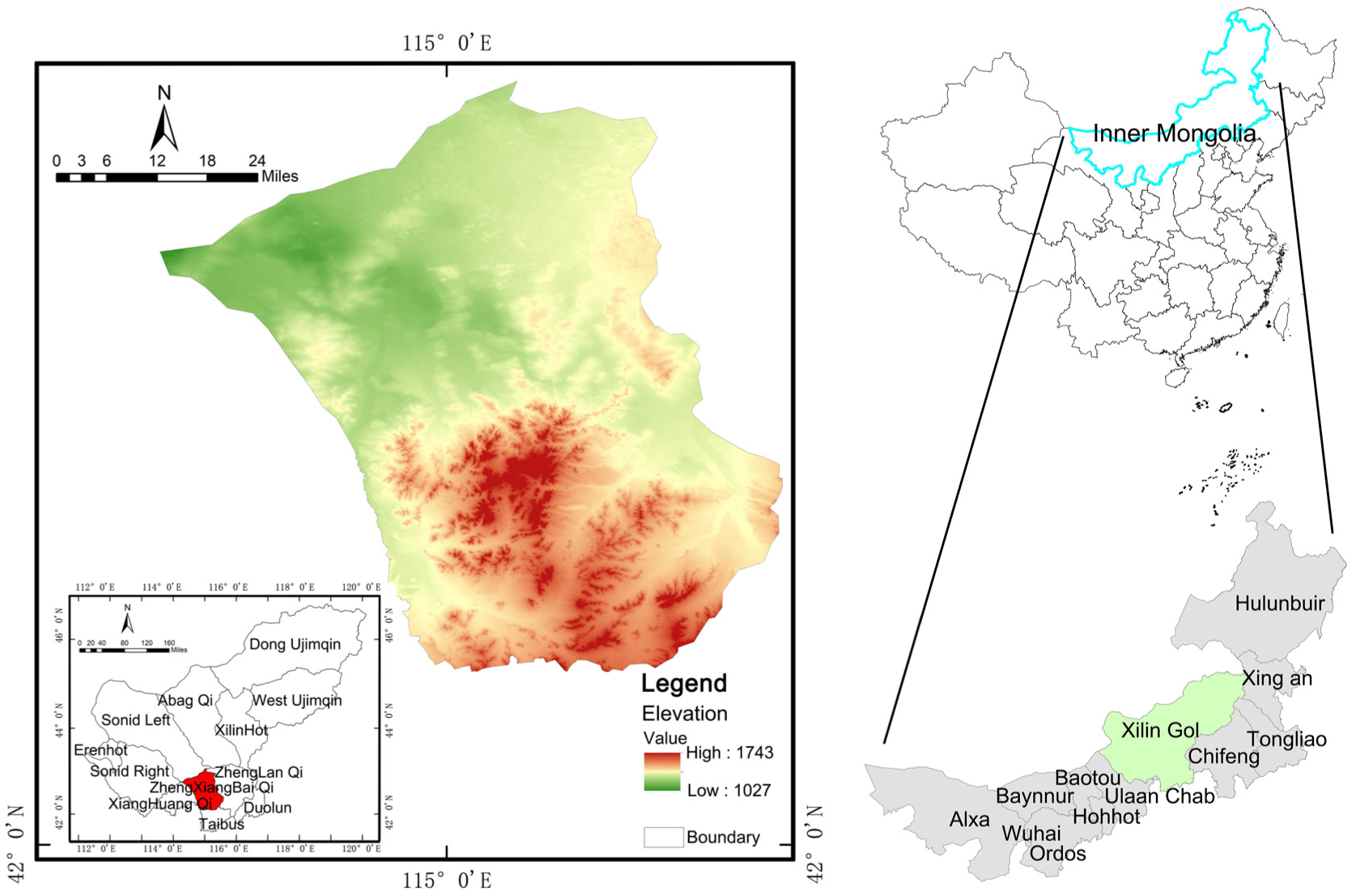
The location of the Zhengxiangbai Qi.

Zhengxiangbai Qi topography and geomorphology.

Zhengxiangbai Qi spatial distribution of point toponyms.
Data Collection
The data used in this study comprise Mongolian toponyms, their Chinese translations, and land-use and land-resource datasets. Point-feature toponym coordinates were obtained from the Amap (Gaode) Open Platform. The name list adopts the post-2002 text following the renaming of the central township jurisdiction, as recorded in the Zhengxiangbai Qi Gazetteer (2000–2010). The toponymic objects analyzed include town jurisdictions, sumu (townships), gacha (administrative villages), groups (natural villages), and names of landforms and rivers/lakes. Toponym meanings were compiled from Chinese Transliterations of Mongolian Toponyms and cross-checked against county annals and other historical sources, with field interviews used for validation and correction. For spatial landscape-pattern analysis, land-use data were taken from GlobeLand30 (1-km raster), and land-resource data were obtained from the Soil Science Data Center.
Methodology
Toponymic Cultural Symbol Decoding Method
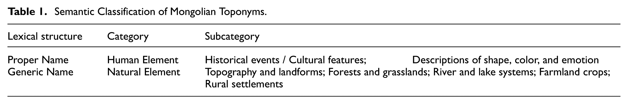
By consulting the “Zhengxiangbai Qi Gazetteer (2000–2010),” toponym data for towns, sumu (townships or towns), gacha (administrative villages), and natural village groups were collected. This dataset was supplemented using the map open platform and corrected through field interviews to address errors—such as homophones with different meanings or a single location possessing multiple names—that arose during the translation of Mongolian toponyms into Chinese, which lays the groundwork for the subsequent decoding of toponymic cultural symbols. For statistical classification, the study adopted the categorization rules from the “Toponym Classification and Category Code Compilation Standards (GB/T18521.2001),” which divide toponyms into natural geographic entities and human geographic entities. Given the specific nature of Mongolian toponyms and the unique administrative divisions in grassland areas, the toponyms were further refined and classified after reviewing relevant literature on their lexical structures and meanings (see Table 1).
Semantic Classification of Mongolian Toponyms.
Building on this, to reveal the pastoral cultural substrate embedded in toponymic cultural symbols, we employ semantic network analysis to construct an association network among toponym semantics and to parse interrelations among place-names. Using degree centrality and betweenness centrality, we identify core toponymic semantic symbols across different word-formation types (e.g., proper–generic structures), thereby quantifying and revealing naming regularities and cultural representations, and pinpointing patterned, representative, and value-bearing symbolic content (Dong & Hu, 2018). By establishing both a classification system and a network for Mongolian toponym semantics, this approach discloses the theoretical logic of the cultural landscape from a symbolic perspective and provides a basis for the spatial re-presentation of symbols.
Spatial Landscape Pattern Analysis Method
We adopt spatial autocorrelation and spatial clustering as quantitative methods to link toponyms with landscape. Spatial autocorrelation comprises global and local forms; we primarily use local spatial autocorrelation to probe spatial heterogeneity in specific areas and to reveal local clustering or interdependence patterns (Li, Wang, et al., 2011). This enables a quantitative test of whether the spatial distributions of toponym semantics and landscape elements deviate significantly from randomness. Spatial clustering is then used to identify local high- and low-value clusters, delineating spatial units where symbol–function linkages in the cultural landscape are most pronounced, and providing a classification basis for differentiated pathways of value shaping and conservation–use. Guided by Tobler’s First Law of Geography—that geographic phenomena tend to be spatially associated and decay with distance (Wei et al., 2021). Toponyms function as spatial markers for the locations of natural or cultural geographic entities. Mongolian toponyms, in particular, encode spatial images of landscape elements within a given area. The material distribution of these elements constitutes the spatial basis of landscape patterns. Therefore, before examining the spatial interactions between landscape elements and toponyms, we first map the distribution of landscape elements in the study area. Using toponym point coordinates, we then quantify their associations with landscape elements via distance-based metrics (e.g., nearest-neighbor distances, buffer overlaps), thereby estimating proximity-based interaction strength and the semiotic correspondence between toponymic symbols and landscape features (T.-Y. Zhao & Rong, 2020). We note limitations: spatial autocorrelation and clustering offer limited capacity for nonlinear dynamics and complex spatial structures, and they cannot by themselves uncover cross-symbol interaction mechanisms between different landscape symbols and toponymic cultural symbols. Even so, these methods allow us to quantify the spatial association between toponymic and landscape symbols, and to translate the abstract “symbol–function–power” relations of cultural landscapes toward value-oriented insights—thereby supporting the theory-validation process.
Research Framework
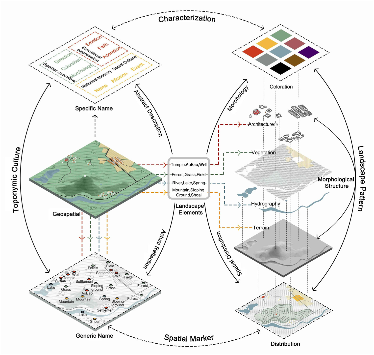
Existing studies have mainly focused on the spatial distribution of cultural landscapes, while neglecting the placement of culture within these patterns. This oversight results in a lack of interaction between nature and culture and fails to meet the needs for coordinated preservation under rural revitalization strategies. Building on the theoretical architecture of cultural landscape studies and inheriting its multidimensional logic of “symbol–function–power,” this paper constructs a translational logic of “symbol decoding–function interpretation–relational analysis.” Under “symbol,” we focus on decoding the semantics of Mongolian toponyms and excavating their cultural meanings, linking place-names to environmental cognition, historical memory, and value. Under “function,” we anchor how cultural landscapes support modes of production and everyday life and the operation of socioeconomic systems, providing the basis for analyzing how cultural symbols reflect spatial functions. We then translate the legacy notion of “power” into an operable “value,” which serves the analysis of relations between toponymic culture and spatial landscape patterns. Ultimately, we mine the cultural and landscape resources of grassland rural settlements, verify the applicability of cultural landscape theory under the Rural Revitalization context of the new era, and articulate a stepwise “symbol–function–value” mechanism for shaping a cultural-landscape community. First, through field investigations of the natural and cultural landscape resources of rural settlements, the study establishes the natural foundations and cultural dynamics. This involves collecting and statistically analyzing Mongolian toponym data and their meanings, as well as extracting spatial data from point-based toponyms. Second, the study categorizes Mongolian toponyms into two groups—“natural elements” and “human elements”—based on their lexical structure and semantics. A semantic network is then constructed to reveal the organization of toponymic symbols. This network is combined with landscape elements obtained from relevant planning and land use data, and GIS spatial analysis is used to identify landscape symbols in the study area. Third, the study examines the functions of toponyms and landscapes from the perspectives of daily life and production, interpreting the functionality of symbols in terms of cultural and geographical cognition. It further analyzes the spatial patterns of the study area and deciphers the interaction between “toponymic symbols” and “landscape symbols” within cultural landscape theory. Finally, by spatially locating cultural landscape symbols, the study identifies the common functions of culture and landscape in their multidimensional relationship during the process of extracting and shaping cultural landscape value. Propose feasible methods and practical pathways to sustain cultural-landscape value (J. Han & Wang, 2022). This study organically integrates the original theoretical framework of cultural landscape studies—analyzing it from the dimensions of “symbolism–materiality–practicality”—and incorporates diverse technical methods such as GIS spatial analysis and statistical methods. It transforms the original theoretical logic into a value extraction pathway, thereby clarifying its alignment with cultural landscape theory and providing a reference framework for the coordinated revitalization of culture and landscape in frontier ethnic regions, as well as targeted support for contemporary rural cultural revitalization, landscape conservation, and development planning (see Figure 4).

Pathways and methods for translating cultural landscapes guided by toponymic semantics.
Results Analysis
Decoding Mongolian Toponymic and Landscape Symbols
Decoding Toponymic Cultural Symbols
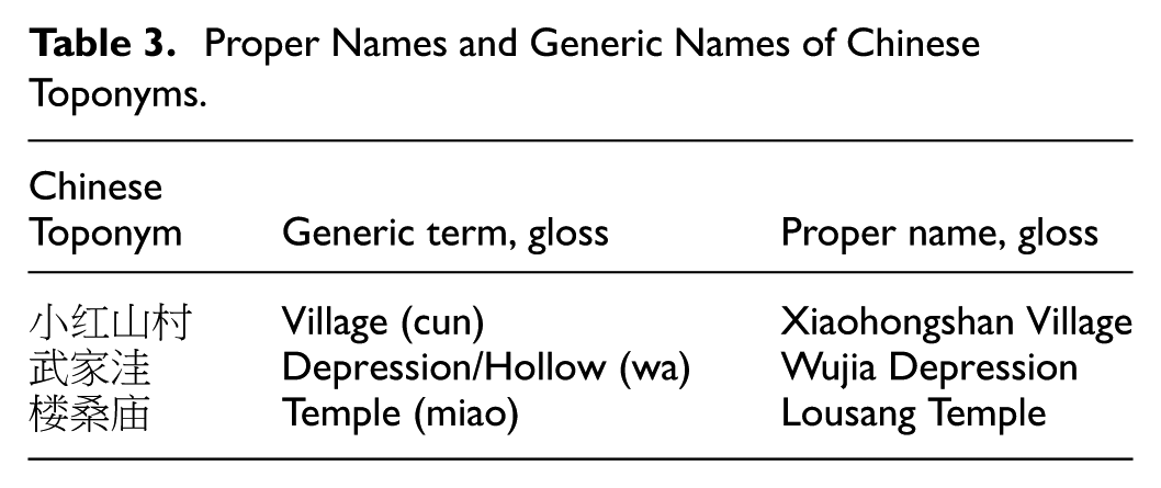
Based on survey statistics, the naming structure of Mongolian toponyms parallels that of Chinese toponyms: the proper name and generic term stand in a modifier–head relation (refer to Tables 2 and 3), and the prevailing naming mode directly references natural entities and provides straightforward descriptions of salient physical-environment features (see Table 4). In terms of word-formation, Mongolian place-names combine different modifiers to describe geographical–environmental characteristics, expressing both an aspiration for a good life and a reverence for nature.
Proper Names and Generic Names of Mongolian Geographical Names.

Proper Names and Generic Names of Chinese Toponyms.
Nomenclature of Mongolian Toponyms.

In the lexical structure of toponyms, multiple generic names can correspond to the same natural feature. Therefore, to explore the inherent natural characteristics and cultural connotations of Mongolian toponyms, this study translates them into Chinese and systematically categorizes and statistically analyzes their naming types, lexical features, and word structures. Ultimately, a correspondence is established between natural and human elements and the categories of proper names and generic names (see Table 5). For the natural element category, the Chinese translations typically encapsulate both the natural features and the reverence and awe that pastoralists hold for the environment. In the human element category, features such as Aobao, Zhaomiao, and nomadic camps—distinct cultural markers in grassland pastoral areas—symbolize the production practices and lifestyles of nomadic peoples.
Classification of Semantics and Lexical Structures of Mongolian Toponyms.

By excluding 169 toponyms with ambiguous or unclear semantics, 611 toponyms were segmented, their semantic features extracted, and a semantic co-occurrence matrix constructed to build a semantic network (see Figure 5). The resulting semantic network shows that elements such as “mountain,”“hill,” and “marsh” occupy central positions, with dense links connecting these core elements to other nodes. This suggests that these core semantics are the primary building blocks in the naming of Mongolian toponyms.

Toponymic semantic network diagram.
Based on the degree and betweenness centrality metrics in the semantic network (Tables 6 and 7), most generic terms (classifiers) function as core semantic nodes, exhibiting high connectedness and strong brokerage—a pattern that reveals a nomadic habit of using landscape elements as spatial referents in naming. Although “spring” is only a secondary core by degree, its high betweenness highlights its cultural influence as a key geographic marker. A similar logic holds for proper terms (modifiers): the higher their degree, the more evident their mediating tendency. For example, “white” and “auspicious” frequently bridge combinations, weaving descriptions of landscape appearance and wishes for a good life into place-names. By contrast, the relatively low betweenness of “black,”“red,” and “rear/back” indicates fewer pairings with generics, reflecting the specificity of certain proper terms in toponym formation and the diversity of landscape character in the study area—an indirect index of pastoral know-how in production and daily life. In the network, edge thickness (arrow width) shows that generic–proper pairings form core semantic clusters; the density of ties reflects a symbolic cognition of geomorphic features and nature veneration among nomadic groups. Some generics lie on peripheral clusters, displaying spatial differentiation and pointing to geographic entities tied to particular spatial–cultural regions. Overall, the network structure indicates that Mongolian toponyms are generated upon a spatial substrate shaped by natural landscapes, with a naming system scaffolded by high-frequency cultural toponymic symbols.
Word-formation Statistics for Toponymic Generic Terms.

Word-formation Statistics for Toponymic Proper Terms.

Decoding Landscape Symbols
Rural landscape resources are divided into natural landscape resources and human landscape resources. Through field investigations and buffer zone analysis using GIS 10.2, the spatial distribution of landscape elements surrounding the point toponyms was mapped. The observed natural landscape resources correspond well with the previously established semantic classification of toponyms, comprising five types of natural landscape elements: mountains, rivers, forests, fields, lakes, and grasslands. The spatial distributions of these landscape elements and the toponym types are illustrated in Figures 6 and 7.
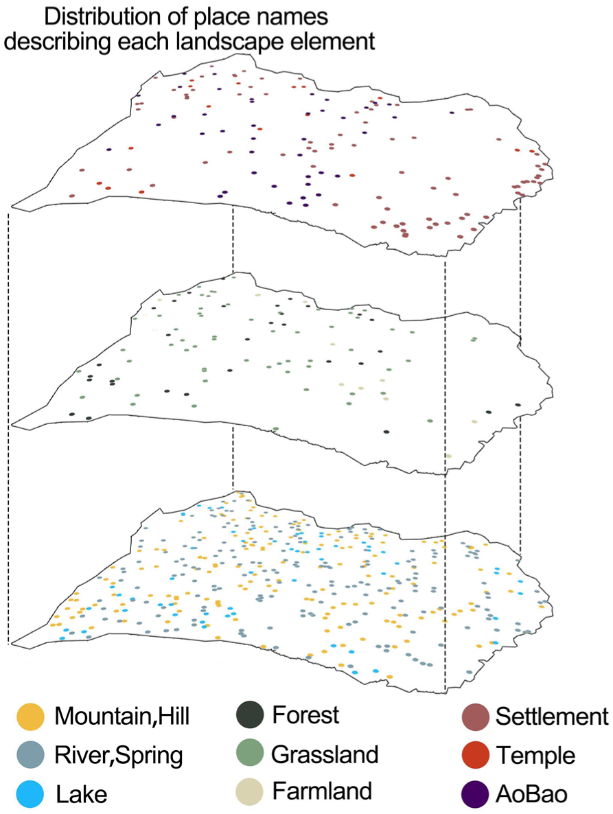
Spatial distribution of point toponyms.

Spatial distribution of landscape elements.
The spatial distribution of natural landscape elements shows both a gradient and fragmentation. In the central area of the banner, the Yinshan Mountains on the northern foothills and the northern Hunsandak Desert, as well as the southern agricultural zone, display distinct elevation differences, with the terrain undulation significantly more pronounced than in the northern and southern areas. This creates a natural foundation characterized by a three-part gradient of “sandy area—grassland—wetland.” In terms of hydrography, seasonal rivers form a “dual parallel line” pattern, primarily exemplified by the Baiqi Hou River that runs through the urban area, along which several settlements are located. In contrast, lake elements are scattered discretely, with lakes such as Yikenaoer Lake and Xiari Ganaoer serving as main focal points that connect wetlands and sandy areas, and with surrounding settlements being relatively dispersed. Regarding vegetation gradients, the NDVI index increases from north to south, and the differences in growth conditions between the shrublands (with species such as Zhen tiao and Sha shao) on sandy areas and the vegetation in the southern meadows, grasslands, and agricultural zones (with species such as Achnatherum splendens grass and You Ruo Lai) reflect a highly heterogeneous geographical and ecological environment. Furthermore, the spatial differences in Net Primary Productivity (NPP) between the northern and southern areas indicate variations in vegetation growth and pasture biomass production, indirectly revealing both impoverished and rich natural landscape resource zones within the study area. The spatial expression of landscape symbols involves the arrangement and combination of various types and scales of elements. Both natural and human landscape components work together to enhance the meanings of toponymic cultural symbols, which also provide directional cues toward landscape elements (see Figure 8).
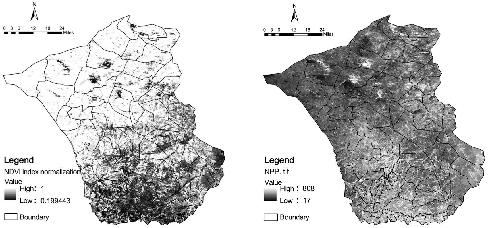
Spatial distribution data of NDVI and NPP in the study area.
Decoding the Functional Attributes of Mongolian Toponyms and Landscape Symbols
In grassland pastoral areas, toponyms play a dual role as both tools for spatial orientation and markers of cultural identity. They serve as a “spatial instruction manual” for the nomadic lifestyle and act as symbolic carriers of evolving grassland culture. For example, the commonly encountered “巴彦陶勒盖” (Bayantaolege) illustrates the nomads’ reverence and awe for natural creations. Similarly, Mongolian characters containing “淖尔” denote the distribution of water bodies, while the generic component “珠斯郎” marks seasonal resource zones and vegetation patterns. These toponymic symbols effectively transform the geographical environment into recognizable rural resources and serve as vessels for cultural memory. Moreover, Aobao—traditional cairns constructed from earth, wood, and stone (Feng & Hu, 2024)—act as tangible symbols of nomadic culture. Their varied functions further enhance the spatial understanding of toponyms. Names such as “锡林敖包” not only represent natural features like highland plains and river systems but also guide nomadic routes by serving as directional markers. In essence, grassland toponyms merge cultural symbolism with geographical cognition through a process that embeds natural symbols, indicates resource spaces, and marks cultural landscapes.
Landscapes inherently possess ecological, aesthetic, social, and economic functions. While economic functions include both tourism and production, the study area’s landscape is primarily oriented toward production. Pastoral production is supported by forest and grassland vegetation alongside water resources. In the southern agricultural zone and the mixed agriculture-pastoral areas, an integrated system combining forestry, croplands, and grasslands enhances overall economic efficiency. On the cultural side, the landscape is mainly characterized by temples and cairns (Aobao), which are imbued with symbolic regional cultural features. Ritual cairns, used in nomadic ceremonies as tangible expressions of natural worship, transmit spiritual beliefs and preserve cultural memory. Grassland towns often develop around temples, which serve as centers of ethnic and social culture; the spatial layouts of these temples are typically closely linked with the surrounding geomorphological environment. The distribution of nearby settlements tends to correlate with local geographic features—such as the spatial patterns of temple complexes, mountains, rivers, and grasslands (D.-D. Xu & Guan, 2017)—thus driving the formation of settlements and commercial buildings, which, in turn, fosters social organization and environmental coordination. Landscape aesthetics represent the spatial realms as perceived by individuals (Lothian, 1999) and are influenced by the variety of landscape types, their structures, and the modes of their configuration (Brown & Fagerholm, 2015). In the study area, the coexistence of the region’s natural resource endowment and localized cultural landscape resources creates an aesthetic function with a distinct identity. Natural landscapes support pastoral production and livelihoods through resource supply, while cultural landscapes—through the power of cultural symbols and the transformation of social space—translate the understanding of geographical and cultural domains into sustainable, functional spaces.
Analysis of the Multidimensional Relationships in Cultural Landscapes
Cultural landscapes emerge from the interaction between various geographical elements and human activities, resulting in a unified spatial pattern that combines natural and human-made environments. This pattern consists of three interrelated and mutually reinforcing components: landscape elements, spatial structure, and landscape functions. In cultural landscape studies, the subject of analysis is multifaceted, encompassing images, language, toponyms, and material forms (Xiang & Lyv, 2010). Consequently, cultural functions and landscape functions are deeply interconnected and often overlap. In the study area, the natural landscape exhibits a spatial pattern characterized by “dual-axis coordination, three-core guidance, and four-regional collaboration.” Vertically, a north–south development axis is established by the Man Gu Line transportation corridor, which connects four major regions and core landscape nodes. Horizontally, a desert–wetland system serves as the linking mechanism between two principal wetland ecological zones. The region’s natural substrate is distinguished by “two waters running through it and an interweaving of forests and grasslands,” with two ecological corridors of water systems in the east and west forming a linear framework. Additionally, the northern sandy areas display a clustered distribution pattern, with an elevation gradient that decreases from the central area toward both the north and south. Temples and cairns (Aobao) are scattered throughout the region, forming specific combinations and spatial connections with other landscape elements. The overall spatial landscape pattern of Zhengxiangbai Qi reflects a system of multidimensional, coordinated coexistence among cultural, landscape, and ecological spaces. This integrated pattern can be summarized as “the fusion of forests and grasslands, the connection of sand and lakes, rivers flowing through urban centers, the coexistence of agriculture and pastoralism, and cultural richness” (see Figure 9).

Spatial landscape pattern of Zhengxiangbai Qi.
By integrating the spatial distributions of various toponyms and landscape elements and performing spatial autocorrelation and spatial clustering analyses, the study ultimately deciphers the spatial landscape pattern in grassland pastoral areas as guided by toponyms. The spatial autocorrelation analysis shows that lakes, rivers, and geomorphological landscapes exhibit significant positive correlations; as landscape elements become more concentrated, continuous, and expansive, their influence on toponyms becomes more pronounced. In contrast, farmlands and temples display significant correlations due to their marked spatial heterogeneity and concentrated distributions in specific regions, while grasslands and forests, with their extensive coverage and strong homogeneity, show weaker correlations. Additionally, cairns and rural toponyms—despite their strong referential qualities—do not exhibit significant correlations. Overall, natural landscape elements exert a broad and substantial influence on toponyms, whereas human landscape elements primarily affect local areas (see Table 8).
Spatial Autocorrelation Between Toponyms and Landscape Elements.


Based on the spatial clustering analysis results, natural landscape elements have a marked impact on both the intensity and spatial distribution of toponyms, forming either “high-high” clusters or “high-low” dispersed patterns. Natural features—such as high mountains, lakes, and main river channels—exert a strong clustering effect on toponyms; the larger and more continuous a landscape element is, the more likely it is to form a “high-high” cluster. In contrast, hills, tributaries, and isolated lakes have a relatively weaker influence and tend to be scattered. Human landscape elements, although they strongly indicate cultural referentiality for toponyms, are limited by their geographic distribution, which may result in unstable or regionally confined clusters and lead to varying degrees of influence on toponyms. Overall, natural landscape elements are the primary driving force behind the distribution of toponyms, while human elements reinforce local functional and cultural referentiality. Thus, the naming logic of Mongolian toponyms is rooted both in the functional perception of the geographical environment and in the culturally guided interpretation of natural spaces (see Figure 10).
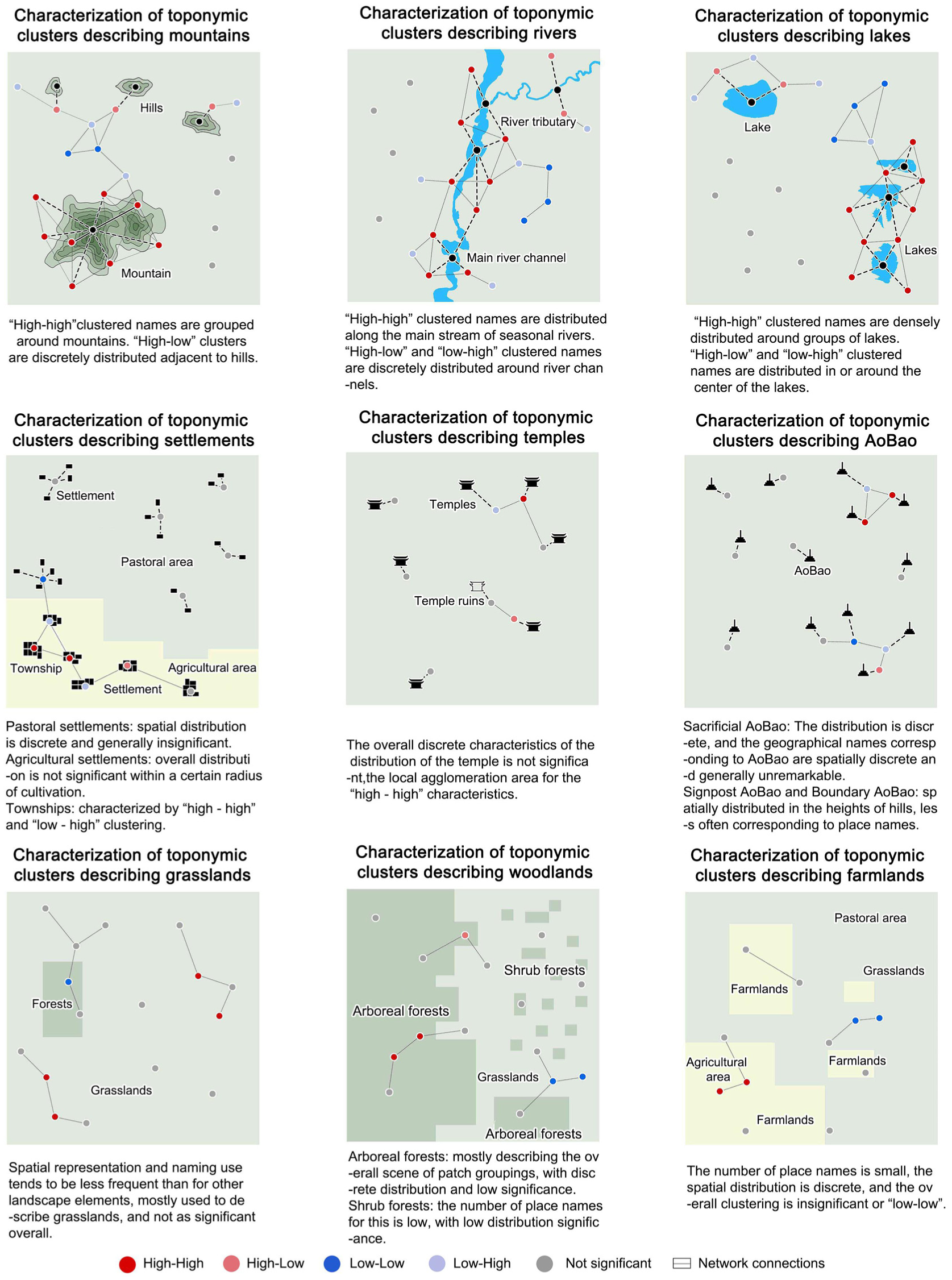
Spatial clustering diagram and characteristics of landscape elements.
The spatial landscape pattern characteristics guided by toponyms reflect the relationships between toponymic symbols and landscape symbols, embodying the multidimensional relationship of “symbol–function–power” in cultural landscapes. The strength of the correlation between toponymic and landscape symbols indicates the directional function of toponyms and the resource-supplying capacity of the landscape, while also representing the varying degrees of “power” inherent in the landscape during the naming process by nomadic peoples.
Symbolic Translation: Spatial Localization of Cultural Landscapes
The generic components in toponyms authentically reflect the landscape elements within a region, simultaneously marking and distributing these elements. In contrast, proper names serve as abstract descriptions of regional landscape features, encapsulating characteristics such as orientation, color, and religious belief. In the toponymic semantic network, the generic name categories are analyzed and described using proper names, thereby forming a complete toponymic semantic system that clearly indicates the corresponding landscape elements. Consequently, a spatial landscape pattern is constructed. In the dynamic interaction between toponymic culture and geographic space, landscape elements expressed as semantic text serve as a medium for transmitting the cultural connotations of toponyms, while the landscape elements in physical space function as carriers of these cultural meanings, revealing their distribution and relationships within geographic space. Through mapping toponymic semantics onto geographic landscape elements, a feedback loop is formed between spatial and non-spatial attributes (see Figure 11).
Feedback loop of toponymic semantics and spatial landscape elements.
The distribution of point-based toponym spatial data serves as a mapping of toponyms onto landscape elements, possessing a degree of geographic referentiality that indirectly reflects the spatial distribution patterns of these elements. Based on spatial autocorrelation and clustering analyses, some Mongolian toponyms still exhibit relatively weak associations with landscape elements. For example, the spatial characteristics of settlement and cairn features tend to be scattered, and the spatial representation and naming trends of forest and grassland elements are comparatively weak. Field surveys, interviews, and other empirical investigations suggest that such misalignments between toponyms and landscape elements are primarily due to changes in landscape appearance caused by natural ecological evolution or human intervention—that is, a gradual decline in environmental quality. Alternatively, discrepancies may arise from differences in the phonetic transliteration between Mongolian and Chinese, changes in land tenure, or alterations in administrative boundaries. In cases where new central towns are established without adequately considering the regional characteristics of various sumu or gacha, the resulting grassland settlement toponyms become blurred within the administrative divisions, leading to a weak coupling between local spatial configurations and their corresponding toponyms.
Functional Regeneration: Coupling Characteristics of Cultural Landscapes
Within the realm of toponymic cultural symbols and landscape symbols, both serve as ecological narratives of landscape resources. By encoding elements such as mountains, rivers, lakes, forests, grasslands, and fields with toponymic semantic labels, a geographical cognitive system of “toponym—landform—river/lake vegetation” is established. The semantics of toponyms directly mirror the diachronic processes of production and everyday life among nomadic peoples, forming an accurate matching system between “cultural symbols” and “cultural landscape resources.” In toponyms, proper names—such as “巴彦” (Bayin) and “赛因” (Saiyin)—elevate natural features to objects of worship, embodying the nomadic ecological ethic of “everything is alive” and demonstrating deep reverence for nature and adaptive responses to its constraints. Moreover, landscape symbols and toponymic cultural symbols are not only sacred metaphors in grassland pastoral areas but also function as spiritual emblems. Cairns (Aobao) and temples, which are distinctive cultural landscape elements in grassland settlements, perform multifaceted roles in the livelihood of nomadic peoples. Through ritual ceremonies, these elements sustain collective spiritual expression and belief, thereby indirectly shaping the multidimensional relationship of “symbol–function–power.”
Mongolian toponymic cultural symbols and landscape symbols each serve distinct functions, and their significant correlation is reflected in the spatial landscape pattern. In translating the multidimensional relationships within cultural landscapes, these symbols exhibit a coupled relationship. Guided by toponymic culture, the functional characteristics of both toponymic cultural symbols and landscape symbols become interconnected. Through the intertextual translation between the symbolic system and the spatial medium, a synergistic coexistence of multiple values is formed. As a result, the intersecting functional attributes of toponymic culture and landscape manifest in several dimensions. First, there is a precise alignment with production and livelihoods, as the toponymic cultural symbol system directly relates to pastoral production resources and ethnic living practices. This alignment supports the nomadic mode of “following water and grazing,” whereby toponyms, through their descriptive portrayal of the geographical environment, clearly indicate and facilitate the adaptive utilization of natural landscapes and cultural resources. The landscape, in turn, serves as the economic foundation—not only as the backbone of agricultural and pastoral production, but also, driven by cultural landscape resources, as a basis for translating ecological value into economic production (for example, through the clustering of settlements and commercial activities around temples, which fosters the development of the tertiary sector). Second, cultural landscapes are characterized by composite nesting. A single human landscape simultaneously carries multiple functions, such as providing directional guidance and representing belief. When the functions of natural landscapes are superimposed on these, they not only maintain the ecological balance of pastures and support rotational grazing, but also function as spiritual carriers for nomadic cultural beliefs and collective memory. In turn, a single human landscape drives the spatial organization of surrounding settlements through the coupled distribution of “mountains, rivers, forests, grasslands, and architecture,” thus achieving an integrated coexistence of cultural and landscape spaces. Third, cultural landscapes demonstrate dynamic adaptability. With the implementation of regional policies and evolving livelihood needs of pastoralists, the functional attributes of cultural landscapes adjust dynamically. For example, seasonal rotational grazing practices have evolved into fixed grazing and settlement patterns, and traditional cairns (Aobao) have been transformed into distinctive landscape nodes, reflecting the elasticity of cultural landscapes. Finally, cultural landscapes exhibit synergy as landscape and cultural functions are perpetuated through the symbolic system—namely, toponymic semantics and ritual practices. This process conveys historical cultural elements such as seasonal nomadism, pasture rotation, and the ritual practices involving cairns, ensuring the intergenerational continuity of nomadic culture. In essence, cultural landscapes serve as the “local chronicles” of a nation, embodying both the material and immaterial aspects of ethnic identity and spiritual cohesion (see Figure 12).

Multidimensional coupling and common characteristics of cultural landscapes.
Value Shaping: The Sustainable Development of Cultural Landscape Space
Within the traditional framework of cultural landscape theory, the underlying logic is a multidimensional representation of “symbol–function–power,” which shows that cultural landscapes serve as material embodiments of social structures and power relations. In the context of current rural revitalization strategies, converting the implicit control of “power” into a practice of value extraction is more favorable for rural development and the advancement of a uniquely Chinese modernization strategy.
In the process of extracting and shaping the value of cultural landscape space, symbols convey ecological wisdom, while functions adapt to meet production and livelihood needs, ultimately reshaping the value of space and resources. First, it is essential to maintain the original functions of both toponymic and landscape symbols to preserve their cultural significance and reinforce their role as “value carriers” that are easily disseminated—for example, by using Mongolian toponyms as cultural intellectual property for tourism and cultural promotion, and by forming cultural landscape spaces centered on diverse practices such as cairn rituals and Nadam festivals. These become markers of local identity, fostering both cultural recognition and economic value enhancement. Second, the varying degrees of coupling between toponyms and landscapes, along with their spatial clustering and dispersion patterns, should be categorized for the conservation and utilization of cultural landscape space. By combining the inherent functional attributes of toponyms with those of landscape elements, network-based approaches can be used to analyze landscape patterns. This involves identifying key landscape nodes through generic toponym components and merging the toponym network with the landscape element network based on their correspondence, centrality, structure, and subgroup characteristics. This method allows for the identification of key landscape nodes, quantification of landscape patterns, and the development of spatial guidance for optimizing and protecting these patterns. Ultimately, this process enhances the functional attributes of spatial landscape patterns, deepens the cultural connotations of geographical features, achieves both landscape conservation and cultural heritage transmission, and promotes regional cultural identity along with the protection of landscape resources. Finally, by optimizing and safeguarding the regional space of cultural landscapes and highlighting the role of toponyms in marking regional culture and the unique features of grassland pastoral landscapes, a sustainable development pathway for rural cultural revitalization and ecological renewal is provided (see Figure 13).

Sustainable feedback loop for cultural landscape value extraction.
Discussion and Conclusions
Discussion
Using a field case in Zhengxiangbai Qi within the grassland pastoral region, this study addresses two pressing issues in contemporary rural settlements—the lack of synergy between nature and culture and the weak linkage to resource value. Through a translational framework of “symbol decoding–function interpretation–relational analysis,” it operationalizes a value-oriented pathway grounded in cultural landscape theory. First, the study systematically translates the cognitive tiers of “symbol–function–power,” verifies the theory’s connotation of “value generation,” and supplements existing work with empirical analysis. Second, the results show strong associations between toponymic culture and spatial landscape patterns, and demonstrate that interactions among cultural-landscape symbols can yield shared functions, thereby filling the gap in the quantitative linkage between toponyms and spatial landscape. Finally, the findings provide practical routes for cultural-landscape translation, value mining, and resource conservation in grassland settlements, broadening application-oriented research on value identification and shaping. The study thereby answers the key research questions posed in the Introduction.
On the theoretical side, drawing on roughly three decades of research in cultural landscape studies, we synthesize domestic and international frameworks and commonalities into an element-cognition tier of “symbol–function–power”(Baldwin & McCracken, 1999; Cosgrove, 1998; Jackson, 2015; Moore, 1994), aligned with systems theory’s “elements–structure–function.” In the Chinese cultural context, cultural landscapes carry deep connotations (W.-Y. Han et al., 2025), and—building on prior efforts to localize cultural-landscape research and practice (J. Han & Wang, 2022)—we clarify the feasibility of value shaping, integrate theory with space and value application, and explain how cultural landscapes manifest in space and are translated into actionable value. This realizes a turn toward “value,” complements earlier studies that emphasized only “symbol,”“function,” or “power” (W.-Y. Han et al., 2025), and extends description-led research grounded in cultural-landscape theory. At the symbol–function level, we use semantic analysis and spatial quantification to demonstrate the linkage between culture and landscape, show that cultural landscapes are an overlay of human activity and natural landscapes, answer the question of spatial representation, and unpack the multidimensional relations among symbol–function–power. Under China’s Rural Revitalization context, traditional cultural and landscape symbols alone can no longer drive development; it is necessary to treat cultural symbols and landscape symbols as an integrated whole. Cultural-landscape theory thus underpins the study of spatial landscape patterns and their ties to culture. Building on earlier experience in studies of landscape patterns and toponyms, we analyze toponymic naming structure from a linguistic perspective and examine spatial landscape patterns. Unlike work centered on spatial structure/layout (Huang et al., 2019), layout planning and ecological design (Ding & Han, 2018), or on merely stating the culture–landscape relationship, this study identifies pattern characteristics of spatial landscapes oriented by toponymic culture and translates them into shared functions of the cultural landscape. It overcomes the limits of distribution-only studies of “toponymic landscapes,” achieves a quantitative reading of cultural-landscape symbols as carriers of spatial function, and completes the morphology and re-presentation of symbolic meaning in space—thereby enriching spatial thinking within cultural-landscape research (X. Tang, 2005) and offering solutions to the loss of voice of cultural-landscape resources and the routinization of production and everyday life. At the level of translating “power” into “value,” we position symbols in space to establish a feedback loop between cultural and landscape symbols. Guided by the parsed symbol–function–power relations, we present the common functional traits of cultural-landscape symbols and, around “symbol” and “function,” reveal pathways for value shaping. In the push to upgrade rural economic quality, the mining of cultural-landscape value and its resource conversion are crucial (Chen & Liu, 2024; X. Tang, 2005). Although some studies link cultural landscapes with value theory (e.g., J. Han & Wang, 2022; X. Tang, 2005; W.-W. Zhao & Huang, 2022), they rarely translate cultural landscapes into value through case-based analysis, tending instead to remain at evaluation systems and cognitive levels, without delving into spatial upgrading or conservation–use pathways for rural resources. In applied practice, our approach aligns with Chinese scholars’ notion of “cultural practice”(Bi & Han, 2017): we emphasize practice-oriented value, seeking to optimize spatial landscape patterns, enhance the communicability of cultural symbols and the conservation–use value of landscape symbols, raise public recognition of grassland-settlement cultural landscapes, and steadily foster virtuous development of grassland settlements.
Supported by the parameterization of toponym semantics, spatial landscape elements, and their patterns, this study proposes—on a rigorous logical basis—a pathway model for mining toponymic cultural value and landscape-resource value, aligned with current needs in rural cultural revitalization and grassland-region development. The replicable “symbol–function–value” practice pathway can also inform development strategies in other grassland pastoral areas worldwide; it has scientific significance for extending cultural landscape theory across regions and offers insights for spatial-value studies in areas with similar cultural-landscape characteristics. Grounded in regional dynamics and regularities, the study provides a context-appropriate methodological framework for cultural-landscape practice and spatial-value shaping across diverse pastoral regions. While this paper outlines an implementable route for translating cultural-landscape symbols and functions into value, it is constrained by the spatiotemporal scope of fieldwork and methodological choices. The dynamic interaction mechanisms between toponymic culture and spatial landscape patterns require further data for validation—especially the compositional effects of different landscape elements on toponymy and multi-factor influences, which warrant deeper investigation. Future work can intensify multi-scale analyses of cultural-landscape evolution and probe the interaction mechanisms between landscape and toponyms to overcome current methodological limits; cross-regional comparisons of grassland pastoral cultural landscapes are also needed to derive more precise conclusions and quantitative evidence characteristic of their evolutionary trajectories.
Conclusion
Guided by the translational logic of symbol decoding–function interpretation–relational analysis, this study systematically addresses key rural challenges—namely the dis-synergy between nature and culture and the broken link from resources to value. The main conclusions are:
The proper–generic naming structure in Mongolian toponyms shows clear directionality toward spatial landscape elements. Their semantics map the interaction between geographical space and toponymic culture; toponymic cultural symbols partly reflect spatial functions, providing an evidential basis for linking toponym semantics with spatial landscape patterns.
Mongolian toponym semantics are strongly associated with landscape elements and patterns. For natural elements, the mechanism of influence on toponyms varies with their magnitude and degree of continuity, producing different coupling relations. Human (built/cultural) features tend to have strong referentiality but, being constrained by their spatial distribution, are more dispersed. Overall, natural landscapes act as the primary driver of toponymic distribution, while human factors further enhance the local functional roles and cultural connotations of place-names. This functionally differentiated pattern indicates a shift in cultural-landscape space from legacy power structures toward differentiated distributions of landscape resources, and achieves a quantifiable linkage between the textual and spatial dimensions.
Within traditional contexts, the “power” relation in cultural-landscape theory can be translated into “value.” Cultural and landscape symbols share common functional relations, thereby establishing a pathway for spatial value mining behind cultural-landscape space and corroborating the core proposition of human–nature synergy in cultural-landscape theory to advance spatial development.
Cultural-landscape theory thus plays an important guiding role in coordinating cultural and natural patterns. Mongolian toponyms, as carriers of grassland-settlement landscapes and history, are a form of ethnic cultural heritage embedded in China’s regional culture. Scientific, effective value mining of natural and human resources in grassland pastoral areas is conducive to the conservation–use of landscape resources and to sustainable protection and transmission of toponymic culture. Taking Zhengxiangbai Qi as the case and focusing on the translation of the cultural-landscape’s multidimensional relations in a grassland pastoral context, this study explores the shift from “power dominance” to “value co-creation,” combining cultural-symbol and functional attributes to realize plural value generation and sustainable development of rural cultural-landscape resources. Theoretical implications: We move cultural-landscape theory from exposition to practice via empirical analysis and foster cross-disciplinary integration among urban–rural planning, geography, and anthropology, extending the theory through a “Chinese paradigm.” Policy implications: We provide applicable ideas for instruments such as tourism-special plans in China’s grassland pastoral regions, promoting synergy between cultural-landscape resources and economic production in grassland settlements. The value-oriented, “symbol–function–value” translational pathway also offers a Chinese solution for other nomadic grassland regions (e.g., Central Asia, North Africa).
Footnotes
Acknowledgements
The authors thank you to the editors and all reviewers for their comments and suggestions. The authors also appreciate the people who patiently participated in the study and to the relevant sections for providing research materials.
Ethical Considerations
Our study did not require further ethics committee approval as it did not involve animal or human clinical trials and was not unethical.In accordance with the ethical principles outlined in the Declaration of Helsinki, all participants provided informed consent before participating in the study. The anonymity and confidentiality of the participants were guaranteed, and participation was completely voluntary.
Consent to Participate
Informed consent was obtained from all subjects involved in the study.
Funding
The authors disclosed receipt of the following financial support for the research, authorship, and/or publication of this article: This work was supported by the National Natural Science Foundation of China Youth Program [grant number 51908297]; the National Natural Science Foundation [grant number 52468012]; Grassland Human Settlement Environment Construction System and Key Technologies [grant number YLXKZX-NGD-004]; Basic Research Funding Projects for Directly Affiliated Universities in Inner Mongolia Autonomous Region in 2025 [grant number ZTY2025025].
Declaration of Conflicting Interests
The authors declared no potential conflicts of interest with respect to the research, authorship, and/or publication of this article.
Data Availability Statement
The data supporting the findings of this study are available from the corresponding author on reasonable request.