
Abstract
This study explores the palimpsest effect of government policies and migration on the architectural layering of Kumkapı, Istanbul. The transformations that have occurred in the physical environment of the district over time have been systematically evaluated through qualitative fieldwork, archive maps, on-site documentation of building facades, and comparative analysis methods. Findings highlight the dynamic interplay between policy, migration, and architecture, emphasizing the need for inclusive urban planning. The findings reveal how migration and political interventions have shaped architectural identity in the process extending from Byzantium to the present; they make architectural layering patterns visible, especially through changes in periodic building uses, facade morphologies, and street texture. The study emphasizes the dynamic interplay between policy, migration, and architecture, highlighting the need for inclusive urban planning.
Plain Language Summary
This study examines the effects of migration and state policies on the physical and social structure of the Kumkapı neighborhood of Istanbul. Kumkapı has historically been home to different waves of migration, which have changed the culture and architecture of the area. The research uses historical maps, observations and analysis to understand these changes. The study reveals how migrant settlements and state policies transformed the identity of the area. The effects of state interventions on urban transformation have been both positive and negative. This study is useful for understanding the effects of migration on urban structures and contributing to future urban planning.
Keywords
Introduction
Located within Istanbul’s Historic Peninsula, Kumkapı is a multi-layered urban settlement shaped at the intersection of successive waves of migration, cultural interactions, and state policies. From the Byzantine period to the Ottoman era, and from the foundation of the Republic to the present day, the area has played a pivotal role in sustaining both social and spatial continuity—owing to its strategic importance in maritime trade and its multicultural demographic composition. As a district where diverse ethnic and religious communities have historically coexisted, Kumkapı holds a significant place in the urban identity of Istanbul—not only through its physical environment but also through its cultural memory and social fabric. This unique character demonstrates that the spatial transformations in the area have been shaped not solely by historical events, but also by state interventions and migratory movements.
This old district, located within the Historic Peninsula of Istanbul (Figure 1) is marked with a spatial projection of migration waves in different periods throughout the centuries. Located between Sultanahmet and Yenikapı, Kumkapı resides within the borders of the Fatih district in the north of Istanbul and borders the Sea of Marmara to the west and the Aksaray and Vefa districts to the east. Its proximity to the Marmara Sea has played an important role in the economic and commercial development of the district, and maritime transportation and port activities have been effective in shaping the district. Today, the district stands out as a dynamic center which bears the traces of social and cultural diversity and historical layering (Figure 1).

Location of Kumkapı.
This distinct character of Kumkapı reveals that the spatial transformations in the area have been shaped not only by historical events, but also by state interventions and migratory movements. Migration has historically been a powerful force that transforms not only demographic compositions but also the physical and socio-cultural fabric of urban settlements. The relocation of populations to new geographic areas not only leads to increased population density but also restructures existing socio-cultural and economic configurations. This transformation often leaves visible traces in the physical fabric of settlements (Belkayali & Ayan Çeven, 2019; Mirlotfi & Jahantigh, 2016). It is driven not only by the cultural practices introduced by migrant communities but also by spatial intervention policies implemented by the state. In particular, regulatory planning decisions, transportation infrastructure projects, and urban transformation strategies play a decisive role in shaping the urban environment. At this juncture, the concept of the "palimpsest" offers a powerful tool—both theoretically and analytically—for understanding the temporal and spatial accumulation within cities.
As articulated in Corboz’s seminal essay The Land as Palimpsest (1983), cities and settlements are akin to surfaces that are continuously rewritten, with each new layer built upon the traces of the previous ones rather than erasing them. This conceptual framework posits that space is not only historically cumulative but also a dynamic construct shaped by political, social, and cultural interventions. Building upon Corboz’s formulation, Didelon (2024) argues that the palimpsest is not only a means of reading the past but also a tool for generating new spatial meanings. In the case of Kumkapı, this understanding provides a foundation for interpreting spatial identity as shaped both by the spatial practices of migrant communities and by state-led regulatory interventions.
In urban contexts, the notion of the palimpsest refers to the accumulation of cultural, social, economic, and physical layers that are successively built upon one another over time, shaped by influential forces such as historical events, wars, disasters, and migration. This process of layering defines the fabric and character of the city (Turgut, 2021), and is both influenced by and influential in shaping the inhabitants’ sense of identity. Edward Casey’s philosophical framework on place memory and layering (Casey, 1997) also contributes significantly to the theoretical foundation of this study. According to Casey, space is not merely a physical backdrop, but a vessel for both individual and collective memory. In this context, the buildings and street network of Kumkapı represent not only physical forms, but also reflections of the social traces left by migrant communities and state interventions.
Previous studies that examine social and built environments through the lens of the palimpsest—encompassing urban identity, cultural identity, cultural heritage, and architectural layering—have contributed to deepening various dimensions of this theoretical framework. For instance, Ren (2021) demonstrates how the architectural palimpsest functions as a representational and political tool in the reproduction of cultural identity. Analyzing Beirut’s architectural evolution, Maskineh (2021) interprets it as a process of cultural transformation shaped by the influence of multicultural structures, while Bartolini (2014) argues that such transformation processes tend to evolve into fragmented, discontinuous, and heterogeneous urban forms over time. Khirfan (2010) contends that the concept of the palimpsest serves as a valuable tool for understanding the interrelations between cultural heritage and contemporary urban forms. Cheshmehzangi and Willman (2023) investigate the role of architectural continuity in reconstructing urban identity within post-industrial landscapes, asserting that the concept of architectural palimpsest plays a significant role in redefining the identities of cities. Another study by Lanz (2023) focuses on the architectural palimpsest in the context of heritage, memory, and adaptive reuse, exploring how the traces of the past can be sustainably preserved and transformed within buildings.
Building upon these theoretical perspectives, Kumkapı emerges as a tangible urban site in which the concept of the palimpsest is materially and socially inscribed. As Huyssen (2003) defines, the “urban palimpsest” refers to a pluralistic yet often conflict-laden urban fabric shaped by the successive settlements of diverse social groups. Within this context, Kumkapı can be interpreted as a geography of memory—shaped through the interplay of migrant communities’ spatial practices and the urban policies enacted by the state. St Louis (2018) further argues that the palimpsest is also a process of identity rewriting, emphasizing that in neighborhoods shaped by migration, the concept becomes critical for understanding the transformation of space.
In this context, the present study seeks to interpret the architectural layering of Kumkapı through the dual lenses of migration and state policies, building upon the aforementioned theoretical foundations. The physical and cultural traces left by migrant communities, combined with the spatial regulatory policies implemented by the state, are examined as interwoven layers within the framework of the “urban palimpsest.” The layered structure of Kumkapı not only aligns with theoretical constructs but also exhibits a particular specificity that expands, reconfigures, and redefines these conceptual approaches. Accordingly, this study does not merely apply the palimpsest theory to the case of Kumkapı but aims to contribute to its critical development by offering new insights grounded in the unique spatial and socio-political dynamics of the district.
Building on this foundation, the study aims not only to apply but also to critically engage with and expand the palimpsest theory through the specific case of Kumkapı. Accordingly, the research is guided by the following questions:
What kinds of lasting changes have migration movements induced in the architectural fabric of Kumkapı?
How have state policies implemented across different historical periods transformed the district’s social and physical environment?
In what ways does architectural layering reflect the cultural representation and spatial belonging of migrant communities?
How does the concept of the palimpsest function as a theoretical tool in analyzing Kumkapı’s historical, cultural, and socio-spatial structure?
What insights does the Kumkapı case, shaped by migration and government interventions, offer for developing sustainable urban conservation and planning strategies?
In line with these research questions, the primary objective of this study is to examine the architectural layering that has emerged through the interplay of migration movements and state policies in Kumkapı, one of Istanbul’s historically significant urban settlements, within the conceptual framework of the palimpsest. Accordingly, the specific aims of the study are as follows:
To analyze the impact of migration movements throughout the historical trajectory of Kumkapı on its architectural morphology.
To examine how state-led spatial interventions—such as zoning regulations, transportation infrastructure projects, and urban transformation policies—have contributed to changes in the physical and social structure of the district.
To interpret cultural layering and forms of social representation in Kumkapı through the analysis of architectural elements such as façades, window forms, material choices, and building heights.
To demonstrate, through the case of Kumkapı, the necessity of a holistic planning approach that embraces cultural diversity and contributes to the development of sustainable conservation strategies.
To contribute to broader academic discussions by contextualizing the forms of layering observed in Kumkapı within the frameworks of international urbanization and migration literature.
These objectives collectively provide the foundation for situating the study within broader scholarly debates, thereby paving the way for a critical engagement with existing literature on urban transformation, migration, and spatial layering.
Literature Review
The concept of the urban palimpsest has been examined across various geographical and socio-cultural contexts, offering critical insights into the multilayered nature of cities and their evolving identities. In the context of Türkiye, Sarihan and Lovra (2024) explore the Ottoman urban morphology of Bursa through descriptive and analytical approaches, presenting a methodology that can also be applied to understanding the historical spatial layering of Kumkapı. Their study underscores the significance of typological and morphological analyses in revealing palimpsestic urban forms.
From Latin America, Arizaga (2021) examines neighborhood transformations in Santiago, Chile, highlighting the role of preserving or erasing historical layers in shaping local urban identity. Similarly, Golda-Pongratz (2023) conceptualizes place-making processes as a dialogic dynamic within the context of the urban palimpsest, arguing that spatial interventions by marginalized communities function as forms of resistance to dominant narratives.
In the Asian context, Tan and Nguyen (2024) explore the coexistence of tradition and modernity within the palimpsestic layers of urban villages in Shenzhen. Their study reveals how informal settlement patterns play a central role in processes of urban transformation, drawing notable parallels to how migrant communities in Kumkapı reinterpret and adapt existing built structures.
In the case of Belgrade, Mladenović and Živković (2023) analyze the visible and invisible layers of memory in Students’ Square, arguing that spatial memory constitutes a fundamental component of urban identity. This perspective directly resonates with Kumkapı, a district characterized by its multilayered architectural fabric and the historical coexistence of diverse ethnic and religious communities. In a subsequent study, Mladenović (2023) employs digital mapping tools to trace the remnants of forgotten urban memory, proposing innovative methods for documenting and representing areas like Kumkapı.
The study conducted by Alabi and Akinbode in Akure, Nigeria, investigates how perceptions of environmental quality intersect with historical layering to produce spatial hierarchies. This phenomenon closely parallels the socio-economic inequalities observed in the development processes of Kumkapı, where architectural stratification reflects deeper social and economic divisions.
In the Canadian context, Léonard et al. (2023) examine the layered struggles between settler urbanism and Indigenous relational place-making, conceptualizing urban palimpsests as spaces of both erasure and resistance. The spatial transformations shaped by state interventions in Kumkapı similarly embody asymmetrical power relations, reflecting parallel dynamics of imposed control and contested urban narratives.
In theoretical and literary studies, Gurr (2022) and Mattheis (2021) explore the concept of the urban palimpsest within literary contexts, emphasizing the roles of narrative, memory, and representation in shaping our understanding of cities. Although not empirical in nature, these works demonstrate the conceptual depth and epistemological potential of the palimpsest as a framework for knowledge production.
The study by Benacer et al. (2022) on Baharestan Square in Tehran and Xu’s (2021) research on urban parks in Nanjing illustrate how public spaces are reinterpreted through multiple layers of meaning as carriers of collective memory. Such spaces offer valuable insights for discussions on public-spatial continuity in Kumkapı, serving as sources of inspiration for understanding its evolving urban narrative.
In summary, the concept of the urban palimpsest manifests across architectural, mnemonic, social, and planning dimensions, transcending geographical and cultural boundaries.
Research Objectives and Methodology
This study adopted an interdisciplinary approach and used a combination of historical and political analysis, historical map analysis, in situ observation, and documentation, and comparative analysis methods. This methodological combination allowed an in-depth investigation of the urban and socio-cultural transformations in Kumkapı and helped reach a better understanding of the spatial effects of migration movements.
To systematically examine the architectural palimpsest in Kumkapı, a purposive sampling method was employed to identify buildings with high representational value that reflect different historical layers, cultural functions, and socio-political interventions. The criteria considered in the sampling process were as follows:
Streets and alleys of historical significance that have maintained spatial continuity from the Byzantine period to the present day and have functioned as centers of religious and communal life,
Chronological representativeness (structures from the Byzantine, Ottoman, Republican, and post-2000 periods),
Functional diversity (residential, religious, commercial, and public buildings),
Morphological characteristics (façade arrangements, number of stories, material types),
Indicators of transformation (visible adaptations, deteriorations, restorations),
Accessibility and documentability (visibility from public space, safety and feasibility for fieldwork).
These criteria ensured a representative and analytically rich selection of buildings that embody the layered transformations of Kumkapı’s urban fabric. Based on this sample, the study proceeded with a multi-scalar investigation integrating historical and political contexts, as detailed in the following section.
Historical and Political Analysis
The study first focused on the migration movements and government policies in the district from a historical perspective with a comprehensive review of previous studies and analysis of relevant laws and regulations. At this stage of the study, primary data sources included the Istanbul Municipality archives, Ottoman documents, reports from the Turkish Statistical Institute (TÜİK), the Official Gazette, the archives of the Grand National Assembly of Türkiye (TBMM), migration policy reports, and data provided by the Ministry of Interior and the Directorate General of Migration Management. From these sources, historical texts, visual documents, fire and zoning records, population data, legal regulations, administrative decrees, state policies, demographic movements, and migration statistics were collected. These materials were systematically organized into tables and evaluated through chronological classification, analyses of historical continuity and rupture, and assessments of the implemented migration policies. A chronological approach indicated the interaction between social and cultural layering followed by the historical map analysis stage.
Historical Map Analysis
In the second phase of the study, the Ayverdi Map (1875–1882) and the Pervititch Maps (1920–1940) were analyzed to trace the evolution of physical transformations in Kumkapı. The Ayverdi Map reflects the structural characteristics, street layouts, and neighborhood organization of the Ottoman period, illustrating changes up to the late 19th century. In contrast, the Pervititch Maps capture the impacts of modernization efforts and migration movements following the establishment of the Republic. For this phase, historical maps were obtained from the collection of the Istanbul Metropolitan Municipality Library and Museums Directorate, and the Istanbul Metropolitan Municipality Geographic Information System (2024) was also utilized. The digitized maps were overlaid and compared, and analyzed in terms of parcel usage, built environment patterns, and street configurations.
In Situ Observation and Documentation
Historical analyses and map studies in the early stages of the study helped understand the changes in the historical context of the places. Photographs served as visual confirmation of this data, showing how the changes materialized in the space in question. A systematic photography approach allowed a visualization of identified streets, buildings, and cultural elements, thus helped translate the study data into a stronger scientific argument. At this stage, a total of 36 streets and 124 buildings in Kumkapı were examined using data related to street texture, building height, functional use, façade and façade details, material usage and color, as well as balcony and window elements. The data were collected and archived through a systematic photographic documentation process conducted between May and June 2024. Photographs—approximately 300 in total—were taken under natural daylight during morning, midday, and afternoon hours along pre-planned routes. The photographic data were classified according to architectural elements and analyzed using a thematic coding method. The resulting codes were structured around the following categories: street layout, building height, functional use, façade and façade details, material usage and color, balcony and window details, and signs of transformation. These codes were then compiled into matrix tables, from which spatial layering patterns were derived.
Comparative Analysis
In historical districts, including Kumkapı, it may not be possible to understand the transformation of architectural layers based on an investigation on textual data alone. For the purposes of the present study, the traces of the layers in the district, their preservation levels, continuity and destruction were analyzed by a comparative approach. Furthermore, matrix tables were used to obtain a clearer understanding of the results. In this final stage, visual and textual data were obtained from historical documents, map analyses, on-site observations, and the documentation of 124 buildings and 36 streets. These data encompassed “building demolitions,”“new street geometries,”“building typologies,”“building heights,”“the degree of street engagement,”“façade materials,”“window details,”“balcony typologies,” and “decorative elements.” The collected information was organized into comparative matrix tables structured according to chronological periods and migration waves. Through these matrixes, patterns of layering were analyzed using a multidimensional approach, including “stylistic superimposition,”“material hybridization,”“functional reuse,” and “additive or subtractive transformations over time.” The resulting findings were interpreted through spatial mapping techniques and interperiod comparisons, enabling the spatial identification of physical traces such as continuity, rupture, and hybridity. This interpretative process revealed how successive sociopolitical changes—particularly migration movements and state interventions—have been materially inscribed into the architectural envelope of the district, thereby rendering visible the complex palimpsest of layers embedded within the urban environment.
Ethics and Informed Consent Statement
This research did not involve direct human participants through surveys, interviews, or experiments. The study focused on the architectural layering and urban environment of Kumkapı, Istanbul, using archival documents, historical sources, and photographic documentation of public spaces. As the data collection took place in publicly accessible areas where individuals do not have a reasonable expectation of privacy, institutional ethical approval was not required, in accordance with APA Ethical Principles. Individuals appearing incidentally in the photographs have been documented in public spaces and their verbal consent was obtained before the photos were taken. To protect anonymity, all identifiable facial features in the images have been obscured.
Historical Overview: The Effects of Government Policies on the Region and Migration Patterns of Kumkapı
Kumkapı, located within the sea walls surrounding the historical peninsula, was a settlement area of choice during both the Byzantine and Ottoman periods associated with its close location to the palace and bazaars and its suitability for port activities (Basut, 2002). The first sources about the history of the district indicate a port called “Kontoskalion” in Kumkapı during the Byzantine period (Kömürciyan, 1988; Müller-Wiener, 2001) with a capacity to accommodate 300 ships and had a breakwater in front of it (Dirimtekin, 1953,p. 57). The city walls which were built as a set of stacked stones during the reign of Constantine I, the founder of the city, are considered the strongest evidence of the Byzantine presence in the district (Demirağ, 2003).
After the conquest of Istanbul during the reign of Sultan Mehmet II, Armenians were brought from Anatolia and settled in Samatya, Yenikapı, and Kumkapı, which were densely populated by Greeks, with an aim to balance the population distribution in the region. The presence of the Armenians in the district further solidified when the Armenian Patriarchate moved from the Surp Kevork Church in the Samatya district of Istanbul to an old Byzantine Church granted to the Armenians in Kumkapı in 1641 (İnciciyan, 1976).
In addition, there were certain policies implemented after the conquest of Istanbul which were also considered effective in shaping the physical environment. For example, the community churches would be left intact and not converted into mosques, and religious ceremonies and worship could be performed as before, but no new churches could be built, and no bells could be rung (Alemdar, 2012, p. 26). Later, this policy was amended by an amicable settlement and accordingly, existing churches could be repaired, provided that Sultan’s approval was obtained, and the building would definitely be same as original upon repairs (Soykan, 2000, pp. 147–149).
Then, Kumkapı became a district of interaction where Greeks and Armenians coexisted, and the two groups shared physical and social environments. Non-Muslims were limited to certain districts, including Kumkapı, Fener, and Balat as per the policies implemented by the Ottoman Empire, and the non-Muslim population in the district gradually increased. There are two Armenian and two Greek churches in the district, the Surp Asdvadzadzin Church, the Surp Harutyun Church which belongs to the Armenian Patriarchate, and the Ayia Kiryaki and Panayia (Elpida) Churches belonging to the Greeks (Basut, 2002, p. 59). In addition to the district restrictions imposed by the government on non-Muslims, other factors which facilitated Armenian and Greek settlement in Kumkapı included the presence of religious structures, the ease of access to the district, and its location that streamlined commercial activities.
The physical appearance of Kumkapı also changed due to the fires which erupted in the years 1645, 1718, 1762, 1826, and 1865, and caused significant damage in the district (Cezar, 1991, pp. 12–51). For example, the Patriarchate building and Bezciyan Armenian Primary School, one of the most important buildings of the district, were severely damaged in the 1826 fire and were renovated by Bezciyan Kazaz Artin Amira in 1830 (Pamukciyan, 2002). After the 1865 Hocapaşa fire, the Islahat-ı Turuk (Improvement of Roads) Commission was finally established (Çelik, 2015). As per the planning work of the commission after the fire, wide roads were opened, the roads were paved with stone, a sewer system was established and, most importantly, taxes on building materials were abolished with an aim to ensure that the buildings were made with masonry technique (Tekeli, 1998). Therefore, the new physical order in Kumkapı turned into houses in row with two, three, or four-floor brick buildings with bay windows, directly facing the street (Akın, 1999, p. 70).
During the Ottoman Empire until the 19th century, new rules were introduced during the Tanzimat (Reformation) Period which had an impact in the field of protection. Forty-two legal and administrative regulations were introduced to govern ancient building protection, including directly the Asar-ı Atika (Ancient Buildings) Regulation and indirectly the Penal Code, Land Code, Ebniye (Zoning) Regulation, Turuk and Ebniye (Roads and Buldings) Regulation between 1848 and 1917, (Madran, 2002, p. 15). The prohibition of construction in mosque courtyards, the prohibition of using wood in external repairs of buildings, and the no charges for the repairs of public buildings, including mosques, schools, and barracks (Madran, 2002) can be given as examples in this direction.
Another important change in the district was undoubtedly the suburban railway built between the coastal area and the residential area in 1872. Kumkapı had its relationship with the sea almost completely cut off (Kuban, 1998). With the construction of Kennedy Street between the years 1956 and 1958, the coastal use which had been vivid for centuries was restricted (Akın, 1999, p. 69). These changes brought an end to the professions of fishing and boating (Akın, 1994), which had long been the main economic activity of the residents of the district, but thanks to the taverns that were allowed to open during the 19th century (Akın, 1999), the district became known for its taverns.
The first migration movement in the district was triggered by the two-day mass attacks against non-Muslims, known as the “6/7 September Incidents.” The events in 1955, which resulted in the burning and destruction of non-Muslim minorities’ homes, workplaces, schools, churches, and valuable assets, deeply affected the socio-cultural structure and non-Muslims were forced to leave not only the district but also the country. Muslims, who migrated from Anatolia began to settle in the areas vacated by the centuries-long residents of the district, that is, Armenians and Greeks, and constituted the majority of the resident identity in the district. Now the new owners of Kumkapı are the people, who migrated from the villages of Anatolia to Istanbul as a result of the economic modernization, industrialization, and urbanization processes in the country during the same period.
The second wave of migration to the district triggered by the emerging Kurdish issue in the eastern and southeastern Turkey (Tolay, 2012). As a result of the policies implemented for the forced displacement of citizens within Turkey, the majority of the people, who had to migrate from the evacuated villages in the eastern and southeastern Turkey after 1984 (Çelik, 2005) settled in the Kumkapı district. Thus, a Kurdish population density emerged in the district and the socio-cultural structure of the district changed yet again.
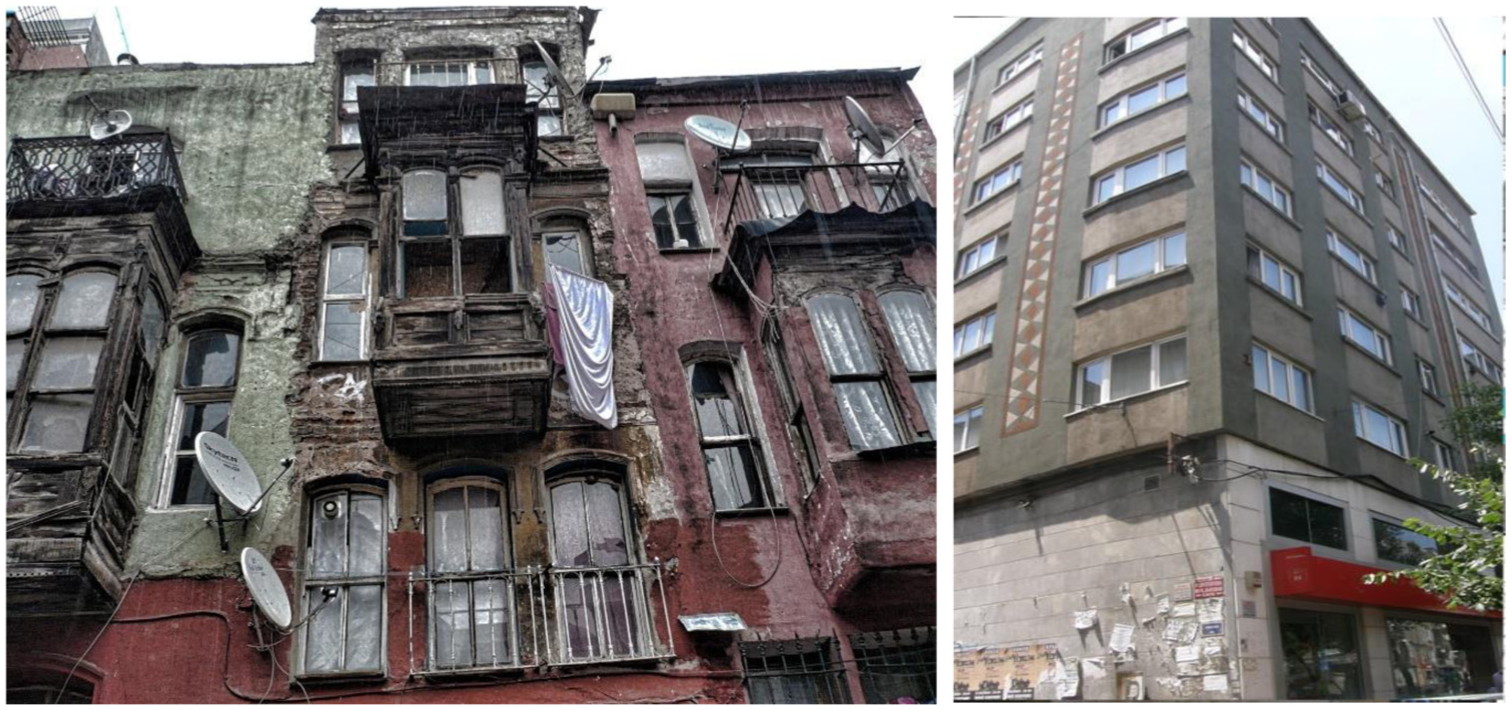
After the 2000s, Kumkapı, has become an important settlement area for people from Syria, Afghanistan, Pakistan, and other Central Asian countries, as well as refugees and immigrants of African origin, in recent years. Furthermore, especially immigrants from the Turkic republics, including Kyrgyzstan, Uzbekistan and Turkmenistan reside densely in Kumkapı. International migration concentrated in Kumkapı, which has become a district where both legal and illegal immigrants reside, has transformed the district into a cosmopolitan space in terms of immigrant profile and spatial transformation processes, making it different from other immigrant districts in Turkey (Figure 2).
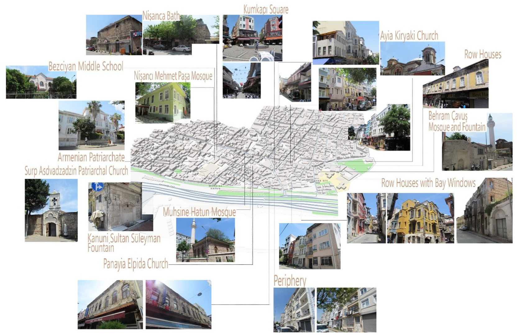
Current physical status of Kumkapı.
Istanbul has received the highest rate of immigration from abroad among in Turkey as per the 2023 data of the International Migration Statistics published by the Turkish Statistical Institute. Kumkapı and its immediate surroundings has been the most densely migrant-populated district in Istanbul province (TÜİK: Türkiye İstatistik Kurumu, 2025). Upon a decision by the Ministry of Internal Affairs, 54 neighborhoods in Istanbul were closed to the residence of foreigners as a result of the fact that foreign population reached 20% of the Turkish Citizens’ population in 2021. Following this decision, the number of foreigners in Kumkapı and its immediate surroundings decreased by 26,589, and the number of foreigners with the right to legally stay in the district dropped to 48,135 (İstanbul Göçİdaresi, 2025). Upon a review of domestic migration in the district, there were 71,501 individuals included in the Istanbul population registry, approximately 77,000 individuals registered in multiple cities, including Mardin, Siirt, Malatya, Şanlıurfa, Batman, and Diyarbakır in the eastern and southeastern regions of Turkey, and approximately 26,000 people registered in cities, including Kastamonu and Rize, located in the western and central Black Sea regions of the country (Fatih Municipality, 2025).
Kumkapı as a Palimpsest: A Comparison of Ottoman, Republican, and Present-Day Maps
The historical continuum and transformation dynamics of urban areas can provide a fundamental context for understanding the identity construct and social memory of a city. The historical fabric of Kumkapı was traced back by comparing the Ayverdi map dated 1875 to 1882 and the Pervititch map dated 1920 to 1940 with the present-day map for the purposes of the study, and the effects of modern urban interventions and migration movements on the district were concretely discussed.
Dated to the third quarter of the 19th century, the Ayverdi Map provides an important source for understanding the dynamics of current structural and cultural changes in the region, especially in terms of organic connections between neighborhoods, street patterns, and building density. The map shows that roads generally extended radially from squares and that there were dead-end streets. The district was not yet affected by large waves of migration and a homogeneous settlement pattern was observed in a period when low-density construction was dominant, While the small-scale blocks shaped the internal layout of the neighborhoods, the streets were positioned around central elements, including mosques and fountains. This layout is indicative of the static and locally focused structure of the pre-migration period. Furthermore, the suburban railway built in 1872 interrupted the district’s relationship with the sea and transformed urban development (Figure 3).

Superimposition of Ayverdi map (background) onto current map (black linear map).
Dated between 1920 and 1940, one of the most striking results from the Pervitich map is the significant changes in the street fabric and block layout of Kumkapı. The organic street networks and small-scale constructions seen on the Ayverdi map gradually disappeared. As a result of the legal and administrative regulations between 1848 and 1917, the dead-end streets frequented on the Ayverdi map are rarely seen on the Pervititch maps. Dead-end streets were connected to adjacent streets or opened to construction. The building names, title information, and functional distinctions on the Pervititch map also shed light on the historical reasons for the spatial transformation observed on today’s map. For example, the residences on the Pervitich map were either converted into different functions, including hotels or commercial buildings, or replaced by larger-scale and modern structures. This caused partial erasure or transformation of the historical memory of the district (Figure 4).

Superimposition of Pervititch map (background) onto current map (black linear map)
Upon comparison of today’s map with historical maps, the direct consequences of factors, including rapid urbanization and migration, can be understood more clearly (Figure 5). For example, the current district map shows eight neighborhoods; each with a different socio-cultural structure, these neighborhoods have a complex structure shaped by the different migration waves and socio-religious structures of Kumkapı (Figure 5).

Today’s map.
An important feature that stands out on the map is the horizontal gray line symbolizing Kennedy Street and the suburban railway. These transportation infrastructures, built between the late 19th and mid-20th centuries, triggered significant transformation processes over the physical structure of the district. Kennedy Street, in particular, has created a clear border between the traditional residential areas in the south of Kumkapı and the newly developing areas in the north, and this transportation axis has played a critical role in the urban development of the district.
Another important element of the map is the interventions carried out through land reclamation as per political decisions to create new venues for large-scale events during the urban transformation process of Istanbul after the 2000s. The fact that the landfill areas shown in white on the map have been designed for large-scale activities, it is difficult to integrate these areas into daily city life These areas qualify as an urban intervention that is incompatible with the historical fabric of the district, which reduces the aesthetic value of the urban landscape due to elimination of the natural coastline of the district. Land reclamation practices have caused further deterioration of the coastal fabric and induced further concretion of the area.
Today, there are a total of 31 religious buildings in the district, including a Patriarchate building, 8 churches, and 22 mosques. The red dots marked on the map by the authors show the locations of non-Muslim religious buildings, including the Patriarchate, Orthodox and Assyrian churches, while the green dots indicate mosques. The location of these structures is a concrete indication of the transformation and diversity in the social and religious structure of the district that Kumkapı was historically a mixed district and that both Muslim and non-Muslim communities lived together. These buildings provide important information about the social fabric of the period and suggest religious diversity in the urban area (Table 1).
Important Religious Buildings in the District.
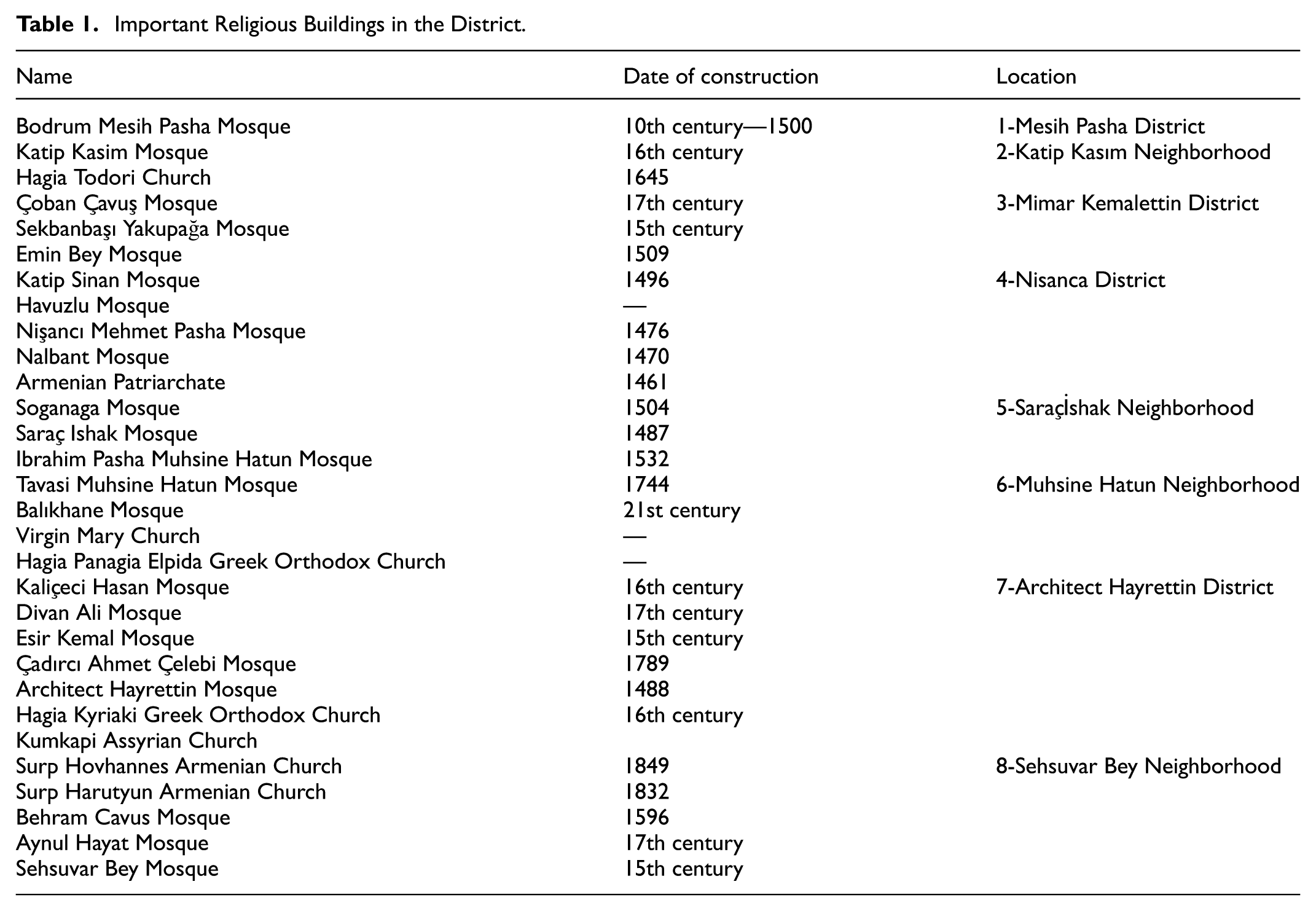
The data in the table above indicate the historical and cultural richness of Kumkapı evident by mosques and churches built at different dates. Especially the Armenian Patriarchate (1461) and Surp Hovhannes Armenian Church (1849) buildings, bear traces of the Ottoman policy of religious tolerance. While buildings, including the Hagia Kyriaki Greek Orthodox Church (16th century) and the Hagia Elpida Greek Orthodox Church symbolize the presence of the Greeks in the district, structures, including the Kumkapı Assyrian Church express how other religious groups existed in this district. Many of the buildings in the table have undergone changes and restoration over time. For example, the Bodrum Mesih Pasha Mosque (10th century—1500), illustrates the historical transformation of a building as an example of the conversion of a Byzantine monastery into a mosque. Furthermore, 16th-century mosques such as the Katip Kasım Mosque bear traces of the Ottoman architecture of the period, while churches including the Virgin Mary Church and the Hagia Panagia Elpida Greek Orthodox Church have undergone multiple restorations over time.
Built Environment in Kumkapı from a Palimpsest Perspective
In terms of building typology, the district exhibits a diverse range from Byzantine-era walls and religious buildings to Ottoman-era mosques and fountains, from reinforced concrete apartment buildings built in the mid-20th century to buildings where commercial and residential functions are used together today. This diversity reflects dynamism resulting from the coexistence of urban and cultural layers. Although traces of the neighborhood culture can still be seen with traditional buildings and narrow streets, the apartment buildings built to meet the housing needs of the increasing population, especially after migration, have paved the way for the emergence of dense and unplanned construction in the district over time. Nevertheless, some of the traditional residential areas were converted into commercial enterprises, and this spatial transformation was accelerated, especially with the intensification of commercial activities and the impact of the increasing population due to migration.
The narrow streets, where neighborhood residents used to have more limited and local interactions, were transformed into more dynamic and multicultural over time. The increase in commercial activities has opened the streets to more international interaction, and the increasingly blurred boundaries between immigrants and locals, along with traces of traditional neighborhood culture, helped shape the social dynamics within the neighborhood. In the more modern streets of Kumkapı, shops and service areas which reflect the contemporary understanding of trade are merged with the height of the buildings, indicating different layers of social interaction in such spaces. Local social ties still exist among tall buildings, and social interactions and commerce continue in functional forms in these streets. Each street of Kumkapı stands out as a space where traces of the past and the present coexist by overlapping and shaping each other in the framework of the concept of palimpsest (Figure 6).

Street interactions at different layers in Kumkapı.
The floor heights in Kumkapı are an important indicator of the evolution and transformation of the social and economic structure in the district. As a port city, Kumkapı was characterized by low-rise buildings that combined commercial and residential functions during the Byzantine and Ottoman periods. Multi-floor modern buildings which emerged as a result of the increasing population density and busy commercial activities in the district indicate a more complex structural evolution. These new structures were built to accommodate the more modern settlement and trade approach of the district and meet the local economy and social needs. Each building and each floor can be read as layers reflecting changing functions, social structures, and urban policies over time in the context of the palimpsest (Figure 7).

Floor heights of different layers in Kumkapı (7a, 7b, and 7c from left to right, respectively).
Archaeological finds prove the existence of structures related to the port during the Byzantine period. Although these buildings are not preserved today, the city walls, churches, and some commercial buildings in Kumkapı remain standing as important traces reflecting the deep history of the district. Occasionally, the previous architectural details of a building provide clues about the social structure and uses in the past, with the previous layout of the windows reflecting the historical aesthetic understanding and level of workmanship. The modern buildings in the district symbolize an important change in Kumkapı. Unlike the older settlement buildings, these new ones emerge as modern buildings combining social and economic functions. These modern buildings which were constructed on and/or near to the traces of ancient structures should be evaluated as buildings in which the functional layers of the past and the present coexist in the context of palimpsest (Figure 8).

Different uses in Kumkapı.
The façade materials in Kumkapı are concrete indicators of the changes and social transformation in the history of the district.—Stone from the Byzantine period stands out as the symbol of Kumkapı’s solidity and permanence, and the aesthetic and functional contributions of stone are evident in the foundations and walls of these structures. In addition to traditional materials, including stone and brick, the use of local materials, including wood, increased with the Ottoman period. With the waves of migration, traditional materials, including stone and wood were replaced by painted brick and plaster. There is a wide variety of façade materials in the district. This diversity creates a palimpsest effect indicative of how different cultural and social identities sustained an effect on space during the settlement process of different migration groups. The old stone façades were replaced over time by new, more modern materials as a result of the increasing influence of trade. These buildings, which meet the practical needs of today along with the traces of the past, is an important indicator of the architectural palimpsest and layering process of Kumkapı (Figure 9).

Different façade materials in Kumkapı.
The façade colors in Kumkapı are important indicators which reflect the cultural diversity and social transformation in the history of the district in the context of the palimpsest. Buildings were generally painted in neutral tones and plain colors during the Byzantine period, yet the Ottoman period saw the choice of pastel tones, especially in the Armenian and Greek buildings. Notwithstanding, as immigrant communities settled in Kumkapı, the colors on the façades also transformed. The new settlers’ preference for brighter colors, inspired by their cultural backgrounds, symbolized the socio-cultural diversity in the district and the new lifestyles brought about by this diversity. Within the framework of the palimpsest concept, this incongruous combination shows how layers of the past and the present interact to create a new aesthetic form, but at the same time weaken the historical identity of the district (Figure 10).

Different façade colors in Kumkapı.
Balcony designs in Kumkapı are an important indicator which reflects the historical development of the district and the changes in its social construct in the context of palimpsest. Balconies, especially in Armenian and Greek buildings, were aesthetically elegant and ornately designed, and bay-windowed structures were prominent during the Ottoman period. Nevertheless, the migrated communities which settled in Kumkapı adopted a new way of life driven especially by economic and social needs. The coexistence of old balcony designs with new, functional balconies indicate the evolution in the social construct of Kumkapı and the traces on the urban identity of the district, as a reflection of the influence of different cultural layers and migration movements within the framework of the palimpsest concept (Figure 11).

Different balcony designs in Kumkapı.
Window designs in Kumkapı were generally simple and functional, with stone frames and minimalist details during the Byzantine period. Functionality was prioritized and window designs were aimed at meeting the building’s need for natural light in the most efficient way. More decorative elements began to appear in window designs, especially in the Armenian and Greek buildings during the Ottoman period. The ornaments and elegant frames around the windows went beyond the mere function of providing light and ventilation and also contributed to the aesthetic perception and social context of the space. Nevertheless, a significant simplification in window designs emerged especially from the mid-20th century onwards due to the influence of immigrant communities. The ornate window frames of the past coexist with the simple and functional forms of today, indicating the historical layering and architectural evolution of Kumkapı. Accordingly, window designs in Kumkapı are considered an important structural element symbolizing the cultural richness, social, and economic change of the district (Figure 12).
Different window details.
The façade decorations in Kumkapı were generally in a simple and functional form during the Byzantine period. The durability and functionality of the buildings were prioritized over aesthetics, and natural materials, including stone were used. Nevertheless, during the Ottoman period, the façade decorations, especially in the Armenian and Greek buildings, were significantly enriched. Soft colors in pastel tones make the façades elegant and aesthetically appealing. With migration, economic conditions of the new settlers and the increasing population density paved the way for a great decrease in the decorative elements on the façades with the disappearance of aesthetic diversity and architectural identity in the neighborhood becoming increasingly practical and standardized. Especially with the international immigrants residing in the district in the 2000s, the façade decorations have almost completely disappeared. The façade details in Kumkapı allow us to understand this change and evolution within the framework of the palimpsest concept. The façades have been shaped by new functions introduced to the buildings under the influence of each new period and wave of migration (Figure 13).
Different façades in Kumkapı.
Findings and Discussion
The spatial transformation of Kumkapı constitutes a multilayered palimpsest shaped by successive waves of migration and state policies throughout its historical trajectory. From the Byzantine period to the present, the area has been continuously reconfigured through religious tolerance, commercial development, forced displacements, and international migration flows. The influence of these socio-political processes is reflected in various architectural elements, including material usage, building typologies, structural heights, and façade textures. In this section, the findings are presented under subheadings corresponding to key historical and political turning points. Government interventions are assessed as either positive or negative based on four criteria—heritage preservation, social equity, environmental quality, and economic efficiency—and their relationship to architectural transformation is critically analyzed.
Pre-1980 Architectural Layer: Byzantine and Classical Ottoman Period
During the Byzantine period, Kumkapı (Kontoskàlion) functioned as a strategic port settlement. The imperial policies initiated under Emperor Constantine I promoted the construction of large-scale public infrastructure, including sea walls and religious buildings (Figure 14). The commercial and political orientations of the era directly influenced the urban morphology, resulting in a port-centered physical configuration. These interventions can be regarded as positive in terms of heritage production and infrastructure development.

Byzantine period example of a wall and religious structure.
During the Ottoman period, particularly following the relocation of the Armenian Patriarchate to Kumkapı, the Armenian and Greek populations in the area increased, leading to the emergence of a multicultural religious building stock (e.g., the Surp Asdvadzadzin Church). The organic street layouts and the spatial relationship between religious and public buildings reflect this diversity. The policies of religious tolerance and settlement permissions implemented during this period had positive impacts in terms of social cohesion and cultural pluralism.
However, following the Hocapaşa Fire of 1865, the regulations implemented by the Islahat-ı Turuk Commission—such as the introduction of stone-paved roads, sewerage systems, and new planning decisions—eroded the organic urban fabric. While these interventions improved urban hygiene and accessibility, they also led to the loss of traditional settlement patterns. This transformation is therefore assessed as having mixed effects, both positive and negative.
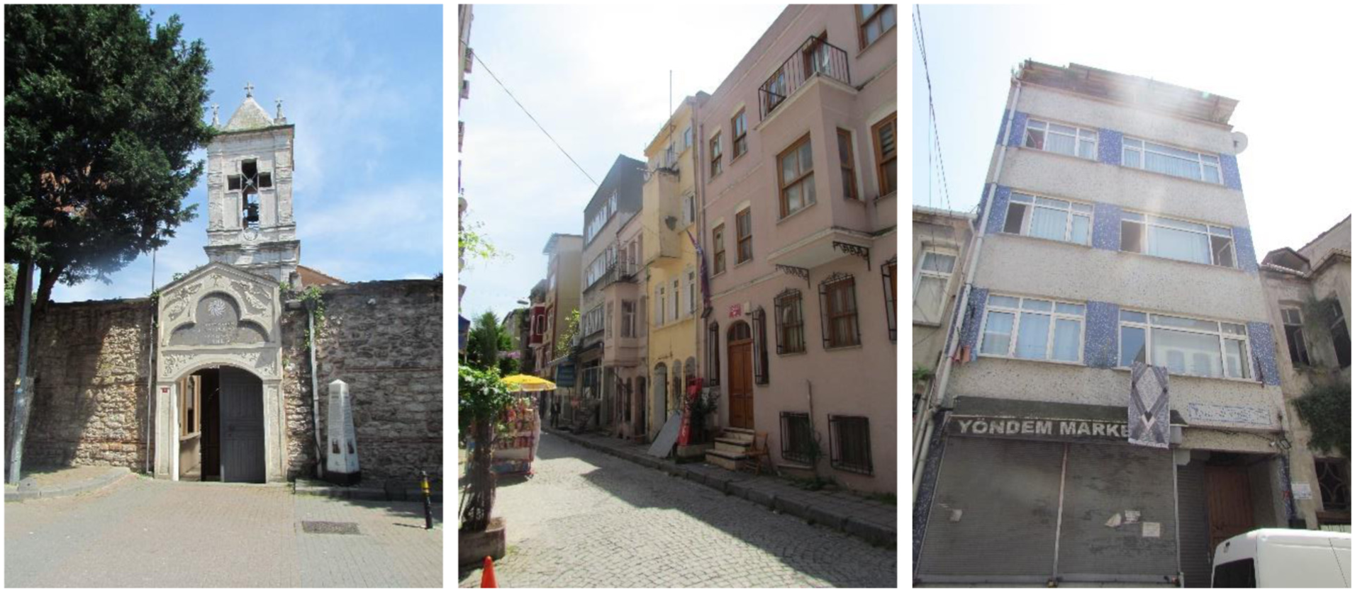
Migration-Induced Transformation: The 1955 Events and the 1984 Forced Migration Process
Following the events of September 6 and 7, 1955, the departure of non-Muslim residents from the area led to the settlement of Muslim migrants, resulting in the emergence of new building typologies in the district. This transformation occurred through the state’s indirect neglect and disrupted the demographic balance, interrupting cultural continuity. In this context, the interventions are considered negative due to their role in weakening the cultural memory of the area.
Following 1984, due to the Kurdish issue, waves of forced migration from eastern and southeastern Türkiye were directed toward Kumkapı. During this period, irregular and multi-story constructions increased, infrastructure systems came under pressure, and problems related to economic and social integration began to surface (Figure 15). Rajan and Bhagat (2021) emphasize that migration movements trigger not only demographic shifts but also spatial transformation processes. In this context, the increase in building density and the rise of unregulated development in Kumkapı as a result of post-1980 forced migration supports theoretical arguments concerning spatial restructuring. Indeed, studies by Obiadi (2022) and Nwalusi et al. (2022) underline that rapid and unregulated migration waves often lead to aesthetic disharmony and social fragmentation within the physical environment. The unplanned development observed in this study aligns with these theoretical perspectives.
Architectural discontinuity from the 1955 events to post-1984 informal urbanization
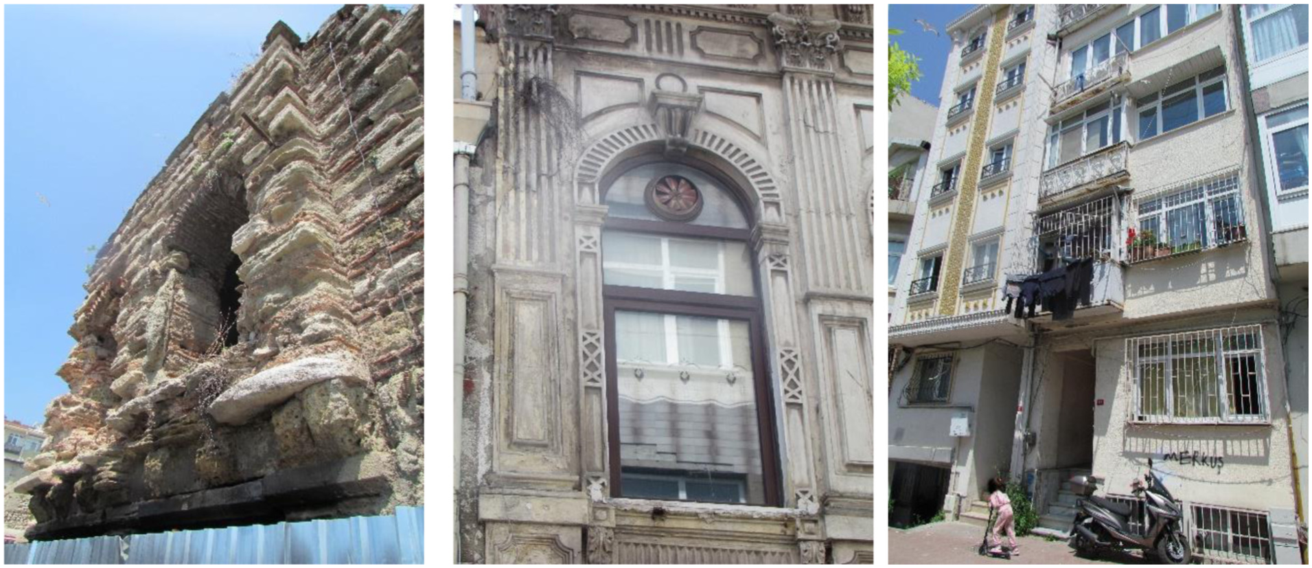
Post-2000 Architectural Layer: The Rise of Multicultural Fabric and Informality
Since the 2000s, the dense settlement of migrants from Syria, Afghanistan, Central Asia, and Africa has intensified cultural diversity and spatial layering in Kumkapı. Basements of older buildings and abandoned structures have been repurposed by migrants as residential and commercial spaces (Figure 16). As argued by scholars such as Tayob (2019) and Lozanovska (2019), migrant-led spatial transformations are not merely physical alterations, but are closely tied to the production of identity, belonging, and spatial strategies. In this context, the adaptive reuse of lower levels in abandoned buildings by migrants and the emergence of hybrid façade textures in Kumkapı have been associated with the theoretical notions of “urban participation” and the “aesthetics of informality.” The findings reveal that migrant actors play an active role in space production, and that these processes are driven not only by practical needs but also by expressions of cultural belonging.

Commercial and residential reappropriation by migrant communities.
The positive aspects of this period include economic revitalization and cultural pluralism; however, its negative dimensions involve aesthetic and structural deterioration. Plaster and mosaic became prevalent in façade materials, while strong contrasts and minimalism dominated color schemes. In balcony and window details, functionality took precedence, accompanied by a decline in overall architectural quality. As noted by Lozanovska (2019), this phenomenon also reflects migrants’ efforts to establish a sense of identity through spatial expression.
Current Situation and New Constraints
As of 2021, with the foreign population in Istanbul reaching 20%, settlement restrictions were introduced, resulting in a decrease of 26,589 individuals in the foreign population within Kumkapı and its surrounding areas. While this has alleviated demographic pressure, it has also introduced uncertainty regarding the sustainability of the area’s pluralistic social fabric. Although there have been minimal architectural changes during this period, cultural pluralism continues to persist. However, in the absence of sustainable urban planning, this condition represents only a temporary balance and poses a long-term risk of cultural erosion.
Periodical and Conceptual Evaluation of the Effects of Government Interventions
In the process of architectural and spatial transformation in Kumkapı, state policies and local interventions have been evaluated based on four key criteria: the preservation of cultural heritage, the development of infrastructure, the promotion of social equity and cohesion, and the enhancement of economic functionality and vitality. In line with these criteria, the positive or negative impacts of government interventions have been analyzed by taking into account the specific conditions of each historical period as well as the physical traces left by migration movements on the built environment.
Positive interventions can be defined as policies that support local identity and ensure the continuity of cultural heritage, infrastructure investments that enhance spatial accessibility, regulations that maintain balance among social groups, and initiatives that strengthen the local economic structure. In contrast, negative interventions include physical actions that lead to the destruction of traditional fabric, forced displacement policies resulting in social exclusion, unregulated development triggered by unplanned urbanization, and practices that contribute to the deterioration of environmental quality. Within this framework, the periodical assessment can be summarized as follows:
The Byzantine and early Ottoman periods represent a generally positive phase of intervention, characterized by policies of religious freedom aligned with cultural pluralism, spatial planning shaped by commerce, and the preservation of traditional building stock. During this period, the integrity of public structures was maintained, and a balance was achieved between social and physical layers.
The Tanzimat era and the post-fire period of the 19th century are evaluated as a dual-impact (mixed) phase of transformation. While significant investments in infrastructure and transportation were made in line with modernization efforts, these interventions simultaneously led to the erosion of the organic urban fabric. A noticeable homogenization occurred in building materials and street patterns, and traditional settlement forms were partially displaced.
The period following 1955 and the 1984 wave of forced migration is marked by predominantly negative impacts, stemming from both the mass departure of non-Muslim populations and the compulsory resettlement of Kurdish communities. During this time, cultural continuity was disrupted, abrupt demographic shifts occurred, and irregular multi-story construction intensified. The transformation of the physical environment, driven directly or indirectly by state policies, contributed to cultural erosion. As Cairns (2024) argues, architecture is not merely a form of physical production but also a mode of political representation. The findings of this study align with Cairns’s approach, which evaluates the relationship between architecture and politics within the framework of spatial justice.
The post-2000 wave of international migration has simultaneously enhanced economic vitality and cultural diversity, while also contributing to a decline in spatial quality and aesthetic degradation. Representing a period of mixed effects, this phase is characterized by an increase in informal transformations, the adaptive reuse of older structures, and the visible imprint of new user profiles on the urban fabric.
The post-2021 period represents a phase of uncertainty, as the effects of settlement restrictions aimed at limiting the foreign population have yet to fully materialize. While the reduction of demographic pressure appears to have introduced short-term order, the long-term implications for the sustainability of the district’s culturally pluralistic structure remain unclear.
The data are also summarized and presented in Tables 2 and 3.
A Comparative Analysis on Migration Movements and the Effects of Government Policies.

Change in Layers of Architectural Elements That Shaped the Built Environment Over Time.

In conclusion, the effects of government interventions in the case of Kumkapı vary across historical periods, intertwining both protective and transformative dimensions within spatial and social contexts. This diversity constitutes one of the core elements of the district’s palimpsestic character and necessitates the development of sustainable urban strategies that take into account its multilayered structure. As argued by Lozanovska (2016, 2019) and Shah et al. (2023), the future sustainability of Kumkapı depends not only on the preservation of its physical fabric but also on the implementation of strategies that sustain social memory and the legacy of cultural pluralism.
Building upon this perspective, the future of Kumkapı can be sustained not only through physical preservation but also through strategies that actively maintain social memory and the legacy of cultural plurality, as emphasized by Lozanovska (2016, 2019) and Shah et al. (2023).
That said, primary social data related to user experiences or the spatial perceptions of local residents fall outside the scope of this study. Although no direct interviews or ethnographic observations concerning the everyday lives of the local population were conducted, the visual documentation and morphological data employed offer compelling evidence regarding the architectural outcomes of migration- and policy-driven transformations.
Conclusion
This study aims to make an original contribution to the concept of the urban palimpsest by examining the architectural layering in Kumkapı within the framework of historical, political, and migration-induced transformations. The findings demonstrate that the dynamic interplay between state policies and migration movements has not only triggered demographic shifts, but also catalyzed functional transformations in the built environment, aesthetic hybridizations, and disruptions in cultural continuity. In particular, the waves of forced migration after 1980 and international migration in the 2000s have led to both spatial densification and formal disintegration in Kumkapı. This process has generated architectural layers that are legible even at the scale of individual streets.
These findings underscore that the waves of forced and international migration have not only intensified spatial density and formal irregularity but have also generated discernible layers of transformation, visible even at the micro-scale of the street. The case of Kumkapı reveals how external forces—such as migration and state interventions—actively shape the process of layering that defines the urban palimpsest. In this regard, the study proposes a reinterpretation of André Corboz’s palimpsest theory, which conceptualizes cities as texts that are continuously rewritten, through the lens of migration-driven and policy-led urban transformations. Accordingly, the palimpsest should be understood not merely as a sequence of historical strata, but as an “urban interface” encompassing interlayer tensions and simultaneities. In particular, processes of forced migration and state-orchestrated resettlement not only generate new physical layers, but also disrupt the continuity of earlier ones, producing what may be termed “cultural erasures” and “spatial conflicts.”
Such disruptions highlight that the urban palimpsest is not a neutral accumulation of layers, but rather a contested terrain where cultural erasures and spatial conflicts emerge in response to socio-political interventions.
The case of Kumkapı offers insights that extend beyond the specific context of Istanbul, providing valuable implications for all urban areas undergoing transformation driven by migration and state intervention. Based on the findings of this study, the following policy recommendations can be proposed:
Participatory Planning Approach: The inclusion of local residents and migrant communities in urban transformation processes is a fundamental step toward strengthening social cohesion and spatial belonging. A participatory governance model plays a critical role in promoting social equity and reinforcing social integration. In the case of Kumkapı, involving both long-term residents and migrant populations in decision-making processes can facilitate a more accurate understanding of their needs and demands, thereby enabling the development of solution-oriented policies. This approach not only enhances the physical structure of the district but also reinforces its social fabric. A participatory planning framework would help preserve the area’s historical heritage while fostering a more democratic and inclusive environment by bringing together diverse segments of the community.
Layer-Sensitive Conservation Policies: Preserving and strengthening architectural and social layering as spatial representations of social interactions within the district offers significant opportunities. The protection of architectural diversity that reflects the cultural richness and historical legacy of the area is a critical concern in Kumkapı and similar urban districts. Therefore, in restoration and renovation projects, it is essential to preserve not only the physical structure but also its historical and social usage. Restoration efforts in such districts should be sensitive to the architectural character of older buildings, ensuring that structural interventions respect the historical fabric. Moreover, these efforts should consider not only the physical aspects of the buildings but also how they are used by local communities and the social relationships built around them.
Environmental Sustainability: Alongside the preservation of the historical fabric, it is essential to integrate infrastructure systems with green transformation strategies. In transformation projects carried out in historic areas such as Kumkapı, environmental impacts should be minimized through the improvement of infrastructure systems, the expansion of green spaces, and the construction of energy-efficient buildings. Furthermore, environmental sustainability should be prioritized in the restoration of existing historic structures. This approach can contribute both to the preservation of heritage values and to the reduction of environmental impacts.
Social Integration Spaces and Activities: Common spaces such as community centers, cultural hubs, parks, and social facilities that promote interpersonal interaction should be incorporated into the design of new buildings. These structures can function as connective elements, facilitating engagement between past and present, and offering opportunities to foster social interaction, preserve cultural identity, and strengthen the social fabric. Cultural festivals, social events, and educational programs organized within these spaces can be particularly effective in accelerating social integration within the district. Such activities enable migrants and local residents to better understand one another, embrace cultural diversity, and learn to coexist. Beyond supporting social interaction, these initiatives also contribute to the preservation and continuation of cultural heritage.
Architectural Integration and Contextual Design: One of the most critical challenges of urban transformation in Kumkapı is the construction of new buildings that are compatible with the district’s existing architectural fabric. Therefore, newly built structures must be designed in harmony with the historical and cultural layers of the area to prevent the loss of urban identity. The integration of modern and traditional elements that reflect the district’s historical character should play a central role in architectural design. Aesthetic balance must be achieved between old and new structures, with modern buildings complementing rather than overpowering traditional ones.
Education and Awareness Building: Education and awareness-building activities are vital for sustaining diversity in a positive and inclusive manner. Fostering a sense of inclusivity and appreciation for cultural diversity among both migrant and local populations constitutes a fundamental step toward social cohesion and mutual understanding.
As with most academic studies, this research also presents certain limitations. Among the most notable is the absence of primary data concerning the lived experiences of local residents, such as surveys or interviews. Given the study’s focus on the analysis of the built environment, socio-psychological parameters—such as user experience, sense of belonging, and perception—were excluded from the scope of investigation. Furthermore, due to limitations in archival access, historical visual comparisons for some streets and buildings could not be conducted.
Future research may explore the spatial strategies of migrant communities, user experiences, and modes of participation in urban planning processes within historic settlements similar to Kumkapı. Additionally, expanding the concept of the palimpsest to encompass not only physical but also emotional and social traces would offer significant contributions to urban theory.
Footnotes
Ethical Considerations
This research did not involve direct human participants through surveys, interviews, or experiments. The study focused on the architectural layering and urban environment of Kumkapı, Istanbul, using archival documents, historical sources, and photographic documentation of public spaces. As the data collection took place in publicly accessible areas where individuals do not have a reasonable expectation of privacy, institutional ethical approval was not required, in accordance with APA Ethical Principles (Section 8.05).
Consent to Participate
Informed consent was not required for this study, as no direct human participation was involved. Individuals appearing incidentally in photographs were documented in public settings. To protect anonymity, all identifiable facial features in the images have been obscured in the final version of the manuscript.
Author Contributions
The first author was responsible for the conceptual framework and literature review. The second author contributed to the methodology and the historical overview. Both authors jointly carried out the In Situ Observation and Documentation.
Funding
The authors received no financial support for the research, authorship, and/or publication of this article.
Declaration of Conflicting Interests
The authors declared no potential conflicts of interest with respect to the research, authorship, and/or publication of this article.
Data Availability Statement
This study did not generate or analyze new primary datasets that could be deposited in data repositories such as Figshare. The research is based on secondary data sources, including archival materials, historical documents, and previously published literature, all of which are fully cited in the reference list of the manuscript. Accordingly, the data supporting the findings of this study are available through the referenced sources.