
Abstract
Due to an increasingly complex mixture of different types of public spaces and their functions in cities, the role of public spaces can be enhanced to serve users under certain circumstances. This paper examines Carmona’s classification of urban spaces in Al-Baha, Saudi Arabia. Carmona introduces a classification that uses aspects of function, perception, and ownership to distinguish between space types. Twenty urban space types are recognized in four groups, representing a variety from clearly public to private space. The classifications of public spaces will be discussed to arrive at classifications for public spaces based on how public spaces are managed. The article builds an understanding of how such classifications relate to how real public spaces are provided today. In this case study, a Geographic Information System (GIS) map is created for Al-Baha Central District and includes the resulting classifications. From the 119 urban spaces selected to represent this study equally distributed across the study area, there are 12 types that public spaces match Carmona’s classification. The classification of urban spaces for this case study revealed the complexity of public spaces’ nature and the difficulty of distinguishing what is public. Public spaces tend to change and develop over time through other uses and activities. However, the classification of public spaces is a valuable tool that policymakers and planners can use to set comprehensive development plan programs and plan open space strategies.
Keywords
Background
It is necessary to understand how people prefer to use public spaces. However, to obtain the successful design and management of these public spaces, the participation of users in the design and management of public spaces and the measurement of their experience of their use of these places should not be neglected (Galiano et al., 2017). Besides, the design, provision, and management of public spaces by the designer, who manages these spaces from the public sector regardless of users’ needs, and how they use them will cause more issues for users (Németh, 2009). In addition to the above, all stakeholders need to understand urban space classifications to follow the guidelines for each type to obtain successful public spaces.
This paper has two objectives. The first is to examines Carmona (2010b) classification of urban space to identify Al-Baha public spaces in significant groups. Second, the paper attempt to identify the different classifications of urban spaces and to establish a better understanding of their relation to each other.
Carmona introduced a new classification of urban spaces that depend on function, perception, and ownership to distinguish between space types. Twenty urban space types are recognized in four groups (positive, negative, ambiguous, and private), representing a variety from public to private space (Carmona, 2010b). Carmona’s classification of public spaces was based on two primary discourses of the public spaces among scholars. First are those who debate that public space is over-managed and those who debate that it is under-managed (Carmona, 2010b). Therefore, examines Carmona’s classification help to understand the context of public spaces in this dialog presented by Carmona to prevent the spread and creation of unmanaged or unused public spaces in Al-Baha and maximize the positive public spaces if they exist. However, the motivation of this approach comes from lacking classification of public spaces rather than the physical shape and function of public spaces. Therefore, the researchers attempt to examine Carmona’s classification in different contexts with different public spaces provision and legal framework approaches. It can contribute to a better understanding of the relations between the different types of public spaces and their use and management to improve the development of urban quality. The paper aims to bridge the knowledge gap in the types of public spaces to understand the classification of public places through a detailed investigation into the multiple, complex, and sophisticated public spaces that were designed, developed, used, and managed in Al-Baha city center.
Literature Review
Classification of urban spaces is beneficial in formulating public spaces policies and achieving a structured plan to provide associated activities with urban spaces. Classification of public spaces is a valuable tool that policymakers and planners can use to set comprehensive development plan programs and plan open space strategies (Carmona, 2010b; Nochian et al., 2015). Since public spaces are the first step to enhancing interaction in cities, the design and provision of public spaces must ensure that they serve the function of integration. Therefore, rethinking urban planning to help encourage public spaces requires a culture change and new public conversations by policymakers that understand the impact of all types of public spaces provided on all users (Morales García de Alba & Atkinson, 2019). Classification can be used as a policy instrument that assists in recognizing how changes occur during the time. It can be a valuable tool for policymakers that let assessment of change over time at various assessment scales (Hall, 2011). Therefore, establishing policy, making investment decisions, and managing space are considered direct and indirect design factors of urban design that shape public spaces in cities (Carmona, 2021). The provision of public spaces involves an integrated approach with a cooperative relationship of design and management within the context of urban policies (Shaftoe, 2012).
Previous studies have provided many classifications and patterns of public spaces, mostly related to open spaces in cities. The classification of public spaces depends on the functional form (Carr et al., 1992; Gehl & Gemzøe, 2001). Most open spaces have been developed in general or open public spaces and have a global nature, regardless of the regional context (Mantey & Kępkowicz, 2018). Lynch (1984) established a classification for categorizing open spaces such as plazas, adventure places, playgrounds, and wetlands. Design perspectives classification here was established to identify the purpose planned for an urban space. Moore and Golledge (1996) attempted to develop a classification of urban spaces in urban areas based on land use types and cultural and visual characteristics. Classifications of public spaces should not be neutral and should be designed and analyzed for their utility as a container for public life (Sandalack & Uribe, 2010). Carr et al. (1992) categorized public spaces in terms of their shape and function, showing 11 categorizations of public spaces in cities: public parks, plazas and squares, memorials, markets, streets, playgrounds, community open space, greenways and linear parkways, atrium/indoor/marketplaces, found/neighborhood spaces, and waterfronts. Shape as a classification-driven approach creates differentiations that proposed by the initial size based. For instance, further subdividing for the classes of streets, intersections, and squares (Beirão & Chaszar, 2014). The issue with such morphologically based approach is that categories of spaces are almost unlimited in their complexity (Carmona, 2010b).
The literature presented many criteria by which public spaces are classified. The first category of classifying public spaces by writers is morpho-functional (Carr et al., 1992; Sandalack & Uribe, 2010). Others focused on the function, character, and shape of the public space (Carr et al., 1992; Sandalack & Uribe, 2010). Other writers classified public spaces according to their management, ownership, and responsibilities (Carmona, 2010b, 2015; Carmona & Wunderlich, 2013). This classification is intended to assist with the diversity of urban spaces based on experiences they provide and for planning, management, and marketing purposes (Nochian et al., 2015). The size of public spaces has also been used as an introduction to the classification of urban spaces in cities (Stanley et al., 2012). Size-based classification illustrates patterns that already give some insight into the structure of urban open spaces. For instance, large parks are considered central focal points, which are immediately distinguishable from smaller squares (Beirão & Chaszar, 2014).
(Carmona, 2010b) classified public spaces based on their ownership and attempted to present this classification as becoming more dominant in an urban area. It depended on dividing the classification of urban spaces into four basic categories: positive spaces, negative spaces, ambiguous spaces, and private spaces in terms of management and ownership (Carmona, 2010b). Carmona (2010b) defines positive spaces as that related to associations and meanings attached to spaces, both positive and negative, varying from person to person. Negative spaces are defined to where some experience aspects of antisocial behavior, including racism and disruptive activities that are often perceived as threatening. Ambiguous spaces are considered uncertain because their ownership and the extent to which these urban spaces are “public” or not are vague. Private spaces are strictly controlled where the right of private ownership allows for the ability to exclude or/and prevent access. Sandalack and Uribe (2010) emphasized that the classification of urban space must be considered with the morphology of the city. They stated that public spaces by themselves are meaningless. Therefore, the design and concept of public spaces must be about its spatial context. The public spaces in Sandalack and Uribe (2010) study were categorized into streets; public squares; parks; gardens and cemeteries; linear motion lanes, such as pedestrian and bicycle paths; camping places; and green and semi-natural natural spaces. Stanley et al. (2012) proposed seven categories to historically assist scientists in identifying and analyzing open spaces in urban areas: food production areas, parks and gardens, recreational space, plazas, streets, transport facilities, and incidental spaces. These classifications mostly focused on the size of the spaces and their ratio to the city. Pokharel and Khanal (2018) developed a classification for general urban spaces: parks, playground, religious sites, caves, aesthetic points, river corridors, messy places that are private property spaces and can be used by the public with some restrictions (e.g., airports), and water surfaces.
The management and categorization of public spaces in cities have been discussed among academic writers. Public spaces were criticized for their management of external and internal public spaces, which was reflected in what they see as a commodity and homogeny of space (Carmona, 2010a). Others, especially critics, focus on what they view as the under-management of external public spaces and represent a negative impact of such spaces as being a poorly designed and insecure public realm (Carmona et al., 2008; Magalhães & Carmona, 2006). Carmona (2010a) classified public spaces based on their physical condition and design and attempted to present this classification to explore their impact on perceptions of public space: neglected spaces: in both aspects, physically and in front of market forces; invaded spaces: where the accommodation of the vehicle is dominant; exclusionary spaces: excluding the least mobile and most vulnerable in society through physical and psychological barriers to their participation; segregated spaces: by separating populations through fear of crime and the determination of exclusiveness; domestic, third, and virtual spaces: by failing to stop broader decline from public space to local, private, and virtual worlds; insular spaces: failing to prevent a more general retreat from public space into a technology-enhanced domestic realm; privatized spaces: by allowing public space to be private and creating social exclusion; consumption spaces: failing to address the relentless commodification of public space and the dangers of financial exclusion of less prosperous segments of society; invented spaces: when condoning the extent of placeless occurred; and, scary spaces: where crime and the fear of it have allowed dominating perceptions of these spaces (Carmona, 2010a).
Management practices have debatably played a significant role in each of these different space experiences, whether positive or negative, within increasingly complex public space types to which management roles and responsibilities both contribute and need to relate (Carmona, 2010b)
Carmona and Wunderlich (2013) also identified contemporary public spaces in London. They developed a new classification of urban spaces that could be applied to most cities around the world. This classification can correctly determine the assessment of contemporary urban spaces—it is a challenge to simplify the current criticisms of public spaces in cities. They looked at London’s spaces concerning the physical form and identified six different types by looking at many spaces: typical piazzas, courtyards, incidental spaces, garden squares, forecourts, and other spaces that encompass the amorphous spaces. Those spaces, which have shown clear correlations with the design aspects, are being created and recreated in London (Carmona & Wunderlich, 2013).
The importance of classifying public spaces in cities lies in the strategy that the city will take in terms of providing and managing these public spaces. For example, the Australian city of Stirling has developed a new classification system that better identifies the different types of public open spaces in the city. It allows an analysis of the provision of open public spaces across the city in various ways and within specific areas through the role, size, population group, location, and timing of its use (City of Stirling, 2008). Seven different categories of classifications have been approved and are reviewed periodically: local open spaces, community open spaces, district open spaces, regional open spaces, natural conservation areas, particular purpose open spaces, and residual land (City of Stirling, 2008). Thus, the city will be able to manage and develop its network of open public spaces with open space effectively and fairly so all residents can enjoy the benefits without placing an unwanted burden on the city’s public resources.
Most urban space typology comes from a limited academic perspective and reviews certain types of public space, but not necessarily identifying the diversity of space types representing cities (Worpole & Knox, 2008). As shown in Table 1, this study adopts Carmona classification because it deals with the increasingly difficult, as public, and private spaces are gradually intertwined in typology based on ownership, function, and perception (Kohn, 2004). His attempts to draw attention to the classification of public space by answering how urban space is managed provides opportunities for many spaces in the modern city to be classified. However, many spaces in this attempt are ambiguous because of their ownership, and the extent to which they are public or not is vague. In conclusion, public spaces can be classified in many ways and can be changed over time according to their use, plan, and control. Urban spaces begin as a representation of a particular type, with a particular range of functions, but are adopted over time by other uses and activities (Carmona, 2010b). Therefore, the quality and responsibilities of public spaces will change throughout their time because of that.
Classification of Public Spaces Attempts.

Methodology
Research Design
The methodology of this study depended on choosing the appropriate case study and the proper data collection tools for this study, after which the analysis of the data collected was covered through an analytical framework for the case study.
This study followed a case study methodology in a qualitative manner (Creswell, 2014), which relied on extensive information that can be obtained from a variety of sources. As a start of this study, Al-Baha city center was chosen as a case study due to the diversity of public spaces that it has.
Study Setting
For this study, the Al-Baha city center was chosen as a case study. The Al-Baha region is in the southwestern part of the Kingdom of Saudi Arabia. The capital city of the Al-Baha region is Al-Baha city (Images 1 and 2). The total area of Al-Baha is estimated at 36,000 km2 (MOB, 2016). The population of the Al-Baha region is approximately 533,001 (MOMRA, 2019), and the Al-Baha region is known for its agricultural land (UN Habitat, 2020).

Development proposal to improve Al-Baha city center

The study area is in the center of Al-Baha city (approximately 250,989 m2).
This study provided classifications of public spaces in the center of Al-Baha city using (Carmona, 2010a) classifications. The classification of urban spaces will be introduced in response to the examination of the chosen classification of urban space by the end of this study. Two approaches have been applied to collect and analyze the data by the author to prepare data for the field study. Those are inventory and classification. First, an exploration survey was carried out to locate all open spaces in the study area. After that, an attempt to understand open spaces’ development processes and function. Then, based on experience from the exploration survey, a structured table was prepared. It consisted of questions regarding the size, location, use, management, ownership, accessibility, and connectivity with the street network. Next, a land-use map was generated to distinguish the function of public spaces. Later, the fieldwork for data collection was carried to classify public spaces according to Carmona’s classification. The study area was field surveyed by the author and 23 students from the Department of Architecture at Al-Baha University after training them to survey all public spaces in the study area. The surveyors were lectured to identify the nature and purpose of the various public spaces within the designated area of this study. The author presented many images of each category of spaces introduced by Carmona from the site and pointed out the essential characteristics of each type. This process gave the surveyors a clear understanding of how to classify each space. After collecting data from the site, public spaces were categorized into major groups and examined and compared to the chosen classifications by the author. This process was repeated twice to achieve a clear typology of public space that is contained in the literature. After identifying the types of public spaces according to Carmona (2010a) (Table 2), the study area was defined, and this research was carried out in two stages: the first in 2019 and the second in 2020. The first stage was to prepare the study area and collect data on 356 public spaces chosen in the study area. In the second stage, 119 locations were selected for re-evaluation after considering them as representative of the public spaces in the study area. All chosen locations were in a table that showed their location number, space type, photograph, a description of the space and notes from the surveyor when there is some concern regarding space in both stages. The two stages will be explained in the following sections.
Classification of Urban Spaces According to Carmona (2010).

GIS Database Construction Process
The author adopted a similar approach used for the same case study in a previous study (Alzahrani, 2022). First, a database for the designated study area was generated using ArcGIS v10.8 to categorize urban spaces and link them to pictures of different spaces (Image 3). The purpose is to support the decision-maker to constantly monitor the area, improve its weaknesses, and provide specialists with an overview of the essential urban open spaces to improve and develop the area (Alzahrani, 2022). For this site, the urban spaces are considered one of the site’s tangible assets that attract investors and developers to invest and initiate the development and improvement process of the area (Alzahrani, 2022). The importance of the database of Al-Baha public spaces comes from the lack of sources that can support the decisions of various stakeholders. Furthermore, it contributes to the foundation for developing public spaces based on the agenda of urban design. In the case of Al-Baha, a GIS database is fundamental and can affect the performance of urban design practice. However, the urban design practice of Al-Baha municipality has not fully and intensively applied the GIS as a tool and as an open source for researchers through its database because the data are not stored in an appropriate database. Therefore, the paper attempts to initiate the database to emphasize the need and importance. Data collected were entered into the GIS software, and different maps were generated. The future step after classifying public spaces is to evaluate the quality and the spatial performance, which will come in part two of this paper. Opinions of local residents and users of urban spaces to obtain information about their needs and monitor their behavior to achieve urban spaces that promote social and physical dimension are done in another study (Alzahrani, 2022). The other part of this study used the database generated from this study to examines the deterioration of the quality of urban open spaces and the valuation of it by the inevitable development of associated management practices (Alzahrani, 2022). It assesses the quality and spatial performance of open urban open spaces after classification using Spaceshaper as an assessment method. The study continues analyzing a digital database for the allocated study area and produces digital maps using geographic information systems with satellite visuals and maps that help planners and decision-makers. Using an assessment tool such as “spaceshaper” which is a practical toolkit created by CABE Space to measure the quality of each open space can show the level of intervention for the public spaces which have different qualities and different interventions would be needed. The method of Spaceshaper occurs by catching the perception of both the experts associated with running urban spaces and the people who use them (Alzahrani, 2022).

GIS data base construction process.
First Stage: A Spatial Survey of Urban Spaces
The inner area of Al-Baha city is estimated at 250,989 m2. A land use map was generated after a site visit in the initial stage to give an early impression of the study area. After an initial process of scoping public spaces and land use of the study area, data were collected, and teams were selected, trained, and divided to collect data for classification. The data were entered into the GIS software, and a map of land use and urban spaces was exported. Carmona (2010a) classification of urban spaces was explained to all team members before site observation (Table 1). Later, the area was divided into five small areas to assist field survey teams in collecting data. Site observations were carried out (Image 4). At this stage, the classification of urban spaces was applied during the site observation.

The study area was divided into five small locations.
According to Carmona (2010a), the classification of urban spaces was grouped into four major groups: positive spaces, negative spaces, ambiguous, and private spaces. Natural/semi-natural urban space, civic space, and public open space are considered positive spaces. Negative spaces include movement space, service space leftover space, and undefined space. Ambiguous spaces include interchange space, public-private space, conspicuous spaces, internalized-public space, retail space, third place spaces, private-public space, visible private space, interface spaces, and the user selecting spaces. Finally, private spaces include private open space, external-private space, and internal-private space (Carmona, 2010b). The classification was explained to the 23 students to conduct the site observation, where the first attempt was made to collect data in February 2019. Field visits at this stage focused on inventorying all types of public spaces, documenting them with photography, numbering spaces on the map, and putting data into prepared tables. All open spaces collected have been identified and classified according to urban space types by Carmona (2010b). The public spaces in Carmona’s classification are classified into 20 types regarding their function, perception, and ownership. There are 374 locations selected at first to represent the study. Next, 18 locations were eliminated because of their difficulty in terms of accessibility. Finally, the rest of the locations (356) were classified according to their land use, function, ownership, management, and physical form and fit them into 14 types of urban spaces by Carmona (2010b).
Second Stage: Classification of Urban Spaces
In the second stage, the collected public spaces were reviewed and examined. The chosen locations were narrowed to 119 locations that were selected to be representative of the classification of urban spaces in Al-Baha. A seminar was held with all team members to discuss the chosen locations. Some spaces were reviewed again for accuracy. The author conducted another site observation for each of the 119 locations, and pictures were taken to examine and compare them to the chosen classification of urban spaces as well as the first field visit.
Therefore, the first stage of data collection was to develop a land use map and to get a comprehensive view of the potential public spaces that can be classified across the study area. In comparison, the second stage is toward narrowing the chosen locations chosen in the first stage and examining them according to Carmona’s classification.
All data were entered into the GIS program to create a comprehensive guide to all public spaces located in the study site, including data, descriptive information, and the current state of public spaces to document the current situation and continuously review and evaluate urban spaces. The second part of this study will document the current situation to show the areas that need to be continually improved and monitor the development in the region over the years.
Findings
The results are presented in two stages of this study. The first stage is on the inventory of land uses and preparing survey teams for field visits to the study area. The second stage is for the classification of urban spaces in the study area. This part is followed by the discussion in which both phases are linked and compared to the relevant chosen classification of urban spaces by Carmona (2010a). The results will be examined for the five areas, and distinguished characteristics of each area are presented using tables, maps, and images.
The Generation of Land Use Map and Urban Space Inventory
This stage took place in February 2019, and data were collected after generating a map of land use. Then, the open space within the study area was calculated using GIS software. By this point, the map was updated and divided into five areas in which to collect data. The land use map generated by the author showed that 32.3% of the study area is allocated as open spaces, which are estimated at 81,087 m2. As shown in Map 1, the area of open spaces, if non-productive farmland is added to it, can represent about half of the area. Non-productive farmland represents 23.9% of the area, with 59,882 m2 as the other primary land use of the area (Figure 1).

The boundaries of the study area and the land use map.

Land use ratios for the study area.
The rest of the land use in the study area was divided between mixed-use residential buildings and regions dominated by labor accommodations working in the area as well as retail stores. Where the area of mixed-use buildings represented 14.5% of the study area as the highest number of buildings with 90 buildings, there are 90 residential buildings, with an area of 31,282 m2 or 12.5% of the study area (Figure 1). The total built-up area is 34%, which is equivalent to 85,390 m2. The percentage of parking lots in this area is equal to 7.4% of the study area, which is 18,579 m2, due to the need for parking for area visitors. The parking is divided into parallel parking next to the sidewalks and parking lots. There are two mosques in the study area, encompassing a total of 1,116 m2. A small museum in this area is the smallest in terms of size. As shown in Table 3, the total area of sidewalks is 16,123 m2. Most of the sidewalks are in Area 1 because the area is full of residential and mixed-use buildings (Figure 2).
Statistics of Uses for the Study Area.

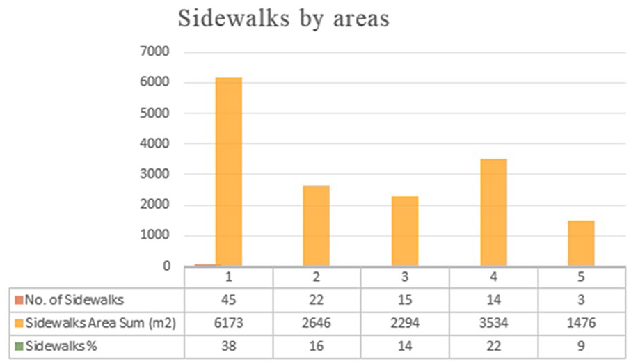
Sidewalks distribution in the five areas.
After the land use map was generated, the author and team members had an initial insight into the area. Site observation took 5 days, and data for the classification of urban spaces were collected. According to the agreed survey form, each public space was photographed and categorized according to the classifications used in (Table 1). Each image was captured and numbered on the map, indicating the angle of its capture (Map 2). Every public space was classified and given a number on the map with a description of the space. Map 3 shows 356 public spaces with the location of the picture. Each site was presented separately in designated tables, which include space type, distinctive characteristics, image number, image, and space description.

Map showing the urban space area, location, and angle of the image captured.

The first stage of data collection in February 2019 and showing 356 points that were identified.
This stage resulted in a preliminary inventory of the types of urban spaces in the study area. As shown in Table 4, a variation of public space typologies occurred in each area. The presence of civic spaces in all large and noticeable size was in both Areas 1 and 2, as they are characterized by the presence of many stores and mixed-use buildings. Therefore, civic space requires the presence of streets and parking lots that facilitate users’ needs. It was also noted that Areas 3 and 4 have significant public-private spaces, mostly used as parking lots for trucks. Area 5 is lacking in civic spaces within the area. Misperceived spaces at the first stage were toward three categories of public spaces as third spaces (20 locations), private-public spaces (1 location), and visible private spaces (12 locations), as shown in Map 3. These spaces are ambiguous in terms of their ownership and the extent to which they are public or not (Carmona et al., 2010). All these urban spaces were examined for accuracy at the second stage before choosing the representative sample of spaces for the classification. Survivors misperceived third spaces due to their confusion about the public open spaces since most of them lack management and services. Most of the third spaces in the study area are abandoned and reused for other functions and no longer serve social places. Third place spaces were eliminated in the second stage due to closing and no longer serving as a third place. Private-public spaces are meant to be publicly owned but functionally determined by users. There were two locations as private-public spaces serve as institutional facilities, but they have been functionally changed. There were 12 visible private spaces in the first stage of data collection. These spaces are physically private but visually public. It was apparent that survivors were confused with the low wall barriers, which in most cases prevent visual accessibility after revisiting these locations. Therefore, all 12 locations were categorized as internal private spaces (Table 4).
Classification of Urban Spaces in the Study Area.

By the end of stage 1, the selected public spaces were reduced after being re-examined. The public spaces of the study area consisted of 12 types of open spaces (Figure 3). As shown in Map 4, 119 spaces selected to represent the study area were equally distributed across the study area. Some private-public spaces were re-examined and classified as civic spaces, as most of these spaces are corridors that buildings pass over and are used for a pedestrian crossing in what seems like the ancient Arab Sabat after returning to these locations and re-examining them. Most of the third places became parts of the sidewalk and the pedestrian corridor and no longer served as third spaces. The ownership line caused some confusion among the surveying team in the first stage, and they considered them as third places and were shifted to service spaces and consequently excluded, as they are not adequately present in the study area. Visible private spaces were eliminated in the second stage due to the uncertain property line between private open space and open public space (Table 5).

Urban spaces in the study area show a significant amount of private open spaces.

Image numbers of the spaces evaluated and entered the GIS database.
The Misperceived Spaces in the First Stage of Data Collection.

Consequently, the selected public spaces that were emphasized in the study area (Map 5) became 119 locations. The author revisited the study area; the site observation took place in January 2020, and the location was photographed and updated again. As shown in Map 5, all 119 images were entered into the database, and their classification was confirmed.
Classifying urban spaces in Al-Baha.
The Classification of Urban Spaces
There were 119 locations chosen in the second stage. The author ensured that the urban space classification relied upon study methodology via site observation. Area 1 is approximately 44,839 m2. King Abdulaziz Road borders the area to the north. King Khalid Road borders it to the east and is one of the roads that is characterized by the presence of commercial shops. This street also offers parallel parking. One-way roads and urban density are considered the highest compared to the rest of the study areas. Prince Faisal bin Muhammad bin Saud Street, one of the main entrances to the area for those coming from King Abdulaziz Road, borders the area to the west. Area 2 is approximately 50,958 m2 and is south of Area 1. King Khalid Road is to the east, Prince Faisal bin Muhammad bin Saud Street borders the area to the west, and Al-Quds Street is south of this area. It is one of the main streets in the study area and one of the most important entrances to the area from King Khalid Road. Area 3 is roughly 52,344 m2 and is located between Al-Quds Road in the north and King Khalid Road in the east. The southern side of this area is considered the edge of the study area with no connection to King Saud Road because the road is higher than the land level. Area 4 is about 62,376 m2 and is located alongside the flood spaces on the northern side. King Saud Road is on the south side; however, there is no entrance to the area from this side due to the level difference between the study area and this road. Prince Faisal bin Muhammad bin Saud Street is on the eastern side, and King Faisal Road is on the western side. Area 5 is approximately 40,470 m2. King Abdulaziz Road borders it to the north, and there are semi-natural spaces to the south. Prince Faisal bin Muhammad bin Saud Street runs along the eastern border, near the main entrance to the area.
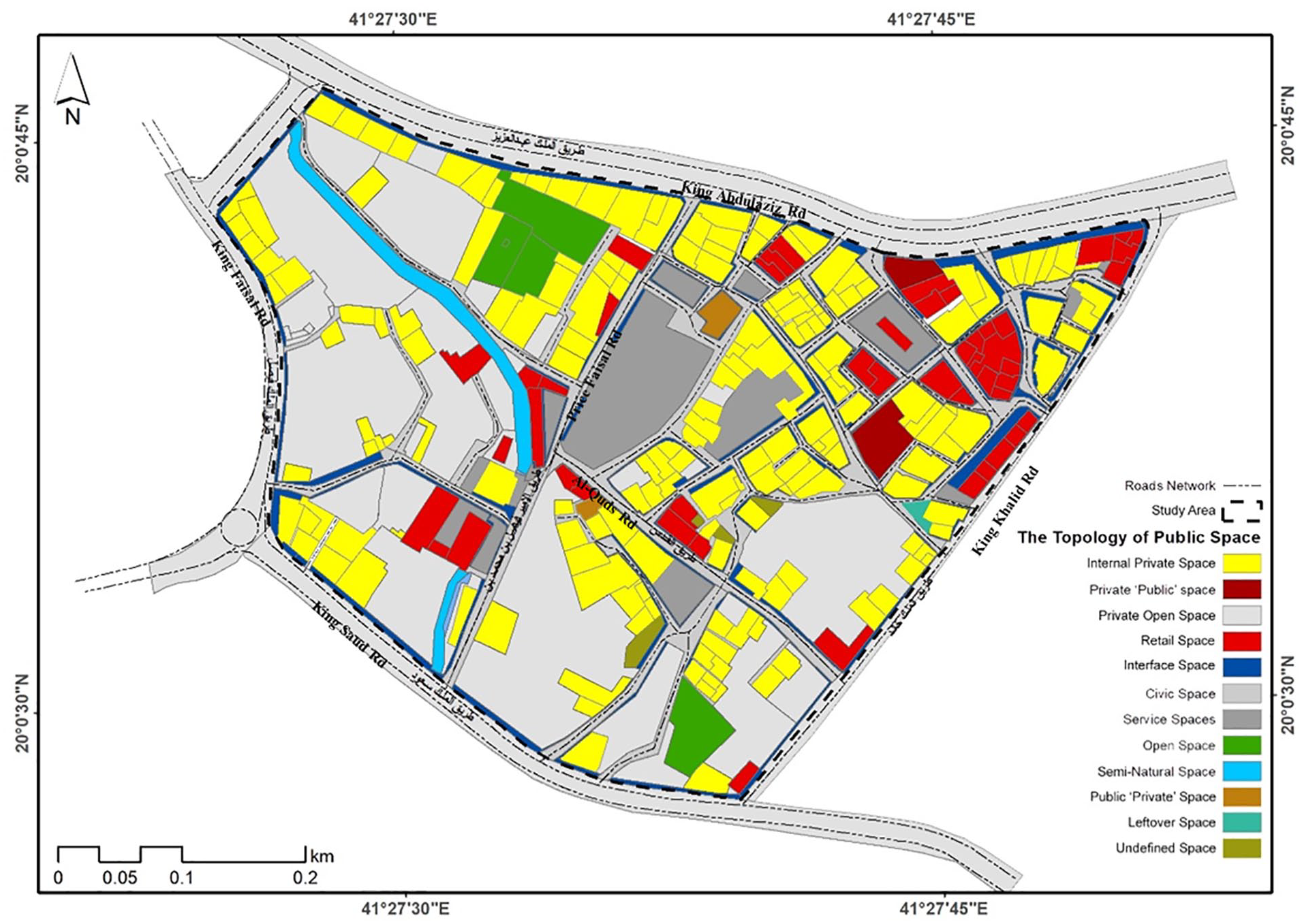
Area 1 has six different types of urban spaces: civic spaces, including streets and sidewalks (Map 6). Even though sidewalks are considered positive spaces, public space has changed significantly with the dominated vehicles, traffic, and parking. As a result, sidewalks and pedestrian space in streets do not have much physical space, and if there exist, many restrictions and frustrations occur. There are service spaces in this area: parallel parking on King Khalid Road and in front of the Gold Market and some internal spaces between buildings. There are some leftover spaces in this area, and there are many interface spaces, which are public spaces and in front of shops and considered a setback for most buildings in this area. There is also one private space in the area that is open to the public (Image 5). It is privately owned and not built land. Internal-private spaces are also the highest in this area, among others.
The boundaries of Area 1 and its urban spaces. As can be seen, it is the densest area that has sidewalks for its users.

A private open space in Area 1, which is neglected, unfenced, and has litter. Such a space negatively impacts the surrounding area and encourages other uses for the space to occur, such as littering.
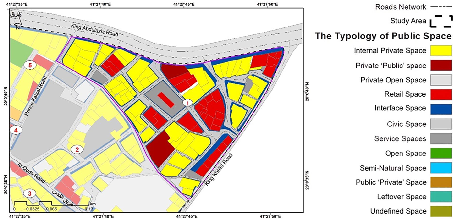
Area 2 also includes six types of urban spaces (Map 7). The primary public spaces in this area are civic spaces, which are streets and sidewalks in terms of public spaces. This area also has service spaces, and there is a considerable parking lot in the study area. It has undefined spaces and a public-private space, the largest mosque in the study area (Image 6), which is located near the parking lots. There are also private open spaces dense with perennial trees. The internal-private spaces are in the middle of this area, surrounded by open areas.

The boundaries of Area 2 and its urban spaces. The most historical square market in Al-Baha shifted over time to be differently used to be parking area that serves the stores around its area.

Public-private space, which is the largest mosque in the study area. A few types of these spaces are in the study area, making them easier to develop and maintain.
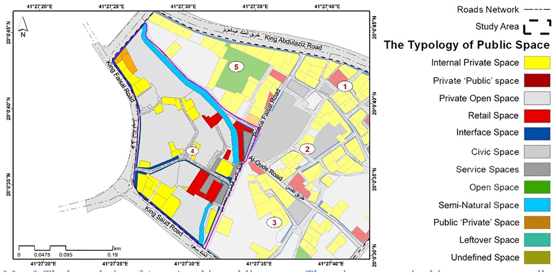
Area 3 is the most diversified in terms of the number of urban space types: civic space, service space, undefined spaces, retail spaces, public-private space, private open space, public open space, and internal-private spaces (Map 8). The public-private space is the second-most important mosque in the study area and located near parking lots on Al-Quds Road. There are also leftover agricultural lands and some open public spaces in Area 3 used for parking. This area has many undefined and private open spaces, which are the most characters. The undefined spaces are one of the most difficult to classify due to regressions and interfaces that make it difficult to predict their ownership or define their use. It is challenging to define undeveloped spaces because of their similarity to leftover, undefined, and private open spaces. In addition, there are no open sources for property ownership the author can rely on while the property line is unclear. Private open spaces surround the internal-private areas.
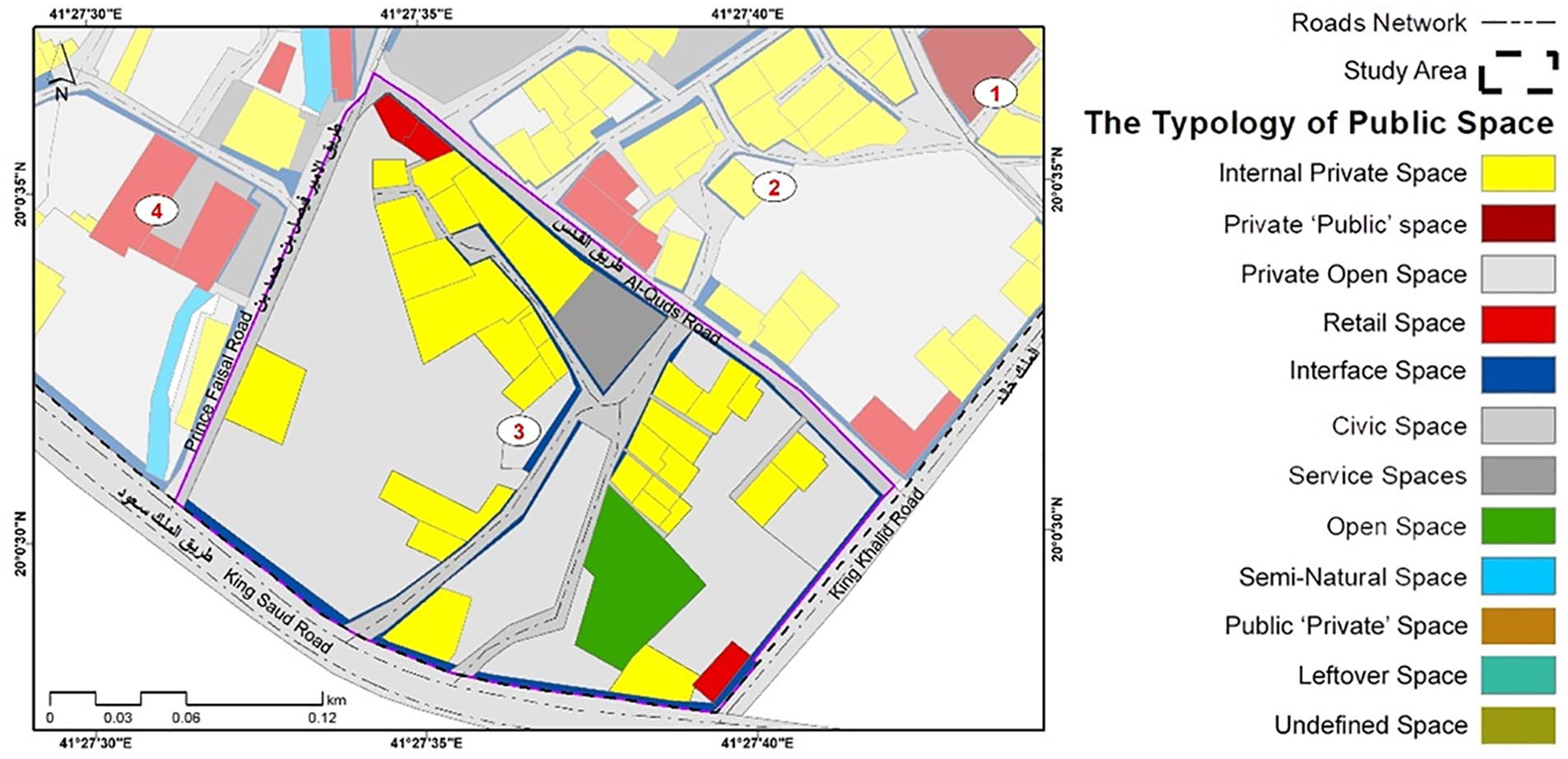
The boundaries of Area 3 and its public spaces. Most open spaces are owned and managed through multiple complex processes in this area. Moreover, it is difficult to recognize how much public and private sectors own in a public open space.
Area 4 contains six types of urban spaces (Map 9). It has a semi-natural urban space, which is a stream allocated for flooding that extends across the area. There are also civic spaces, public spaces, service spaces, and private open spaces. Area 4 is dominated by earthen soil and agricultural remains, lacks the commercial regions of the interior area, and has many public-private spaces. The internal-private spaces are mostly on the western border of the area for access to King Saud and King Faisal Roads (Image 7).
The boundaries of Area 4 and its public spaces. The private sector in this area unexpectedly consumes the public space close to their property, restricting its use as seen in the dates market area.

A private open space that is difficult to reach and develop due to the lack of accessibility and connectivity with the surrounding area.
There are five types of spaces in Area 5 (Map 10). There are civic spaces, including roads and sidewalks (Image 8). Area 5 also has many private open spaces, which are areas in front of houses and agricultural remains, some of which have farms and the other is abandoned. Most private open spaces are used as car parks. The northern side of this area is one of the vital commercial regions in the Al-Baha region, as most of the buildings in the north area are internal-private spaces. There are retail spaces alongside Prince Faisal bin Muhammad bin Saud Street, and there are public open spaces in the middle of Area 5. Area 5 is characterized by the presence of private open spaces, mainly agricultural areas, which have predominantly turned into parking areas.

The boundaries of Area 5 and its public spaces. The municipality is keen to build landscape and sidewalks infrastructure clearly to outline the borders of public spaces and provide a definitive use of the spaces. In addition, it is an attempt to give enough space to pedestrians for movement.

Civic space, as is the case for most of the private external spaces in Area 5.
This study’s classification of urban spaces shows that most of the urban spaces in Al-Baha city were private spaces. The site observation by the author shows the need for improvement of the physical quality of public spaces to have a definitive typology for most ambiguous spaces. The result also shows that the most diverse area of public spaces is not necessarily linked to the urban structure’s density. In Area 1, there are six types of public spaces, while in Area 3, there are eight different types. Internal-private spaces are the most connected to the civic spaces, whereas semi-natural spaces are the lowest in connectivity to civic spaces and accessibility to users. Open spaces shift their use from agricultural land to service spaces that offer parking for vehicles.
Public open spaces of the study area used for several functions that deliver both economic and social value regardless their current physical condition such as roads, sidewalks, and pedestrian space. It is essential to improve the design and the physical quality of such spaces to make them more attractive to potential users, investors, and customers. It is essential for the public sector, such as the municipality, to invest in delivering quality for public open space for several reasons such as increasing mobility, enhancing safety, supporting the local economy, contributing to a sense of social cohesion, and improving the environment. Therefore, public open spaces continually play a key role in improving the quality of life for all.
The possible changes that can occur and directly influence the success of achieving the desired vision of the different urban design solutions are through land use development. Also, the possible changes of the physical transformation of the urban public space cause social change within its urban context. The spatial determinants of activities and interactions show how places affect human behavior. Therefore, the provision of activities is the central core of any place that can define the place and increase its physical quality.
The finding through the site observation shows the diversity of public spaces with a public character. Moreover, it looks for the criteria by which this diversity is organized. It illustrates a unique classification that combines five categories: intended users, accessibility, primary forms of control, functions, and visual characteristics. This classification gives rise to the role of spaces designed not for the public but specific groups and access to restricted spaces. Such public spaces might align with the suburban lifestyle and play an increasingly important role in suburban social life. More and more public spaces appear in the study area by looking at this emerging classification. For example, some public open spaces are temporarily granted the right to host reclaimed parking spaces. Also, some historic public spaces are changing character, such as the old market square in the middle of the center of the study area that turned to the most significant parking area. All these aspects can be studied in more detail in another study where place characteristics are evaluated in a broad range of categories and methodological approaches.
Discussion
There are generally two comprehensive categorizations of open space classification methods used in open public space categorization, that is, typology and classification (Nochian et al., 2015). Typology indicates the type of open spaces regardless of their characters. Using the typology method focuses on types of spaces such as plaza, square, street, market square, park, indoor marketplaces, etc (Nochian et al., 2015). Classification is used when distinguishing characters of spaces are included in the categorization. In addition, open space has different characteristics, which affect how open space is used and valued. Open space’s recognized character is affected by several variables such as location, level of improvement, function, and interaction with affiliated land use and metropolitan structure (City of Stirling, 2008). Carmona’s classification focus on open space categorization based on the classification method. The classification method Carmona (2010b) used in classifying open spaces generally covers three approaches. The distinguishing characteristics of the spaces in terms of function, perception, and ownership were used in his classification. However, the classification of public spaces Carmona produced did not show who would use the open spaces.
Carmona’s (2010b) view of public spaces classification comes from several reoccurring critiques that characterize discussions about public spaces. First, even though his classification differs and goes from the ordinary to the exceptionally dynamic, a highly over/undermanagement polarity should be the principal driver for open space classification (Carmona, 2010a). Second, Carmona’s classification can be seen as not exclusive but overlap and collectively inform perceptions of public space. Third, Carmona’s (2010a) view relies on what public space can or “should offer, often predicated on an idealized notion of public space as an open and inclusive stage for social interaction, political action, and cultural exchange” (p. 144). Finally, even though there are unmistakable recorded encounters for such characteristics, the under-management and over-management critiques might be balanced and straightforwardly add to each other (Carmona, 2010a).
An ineffectively designed and inadequately managed public space prompts the longing of business and local area interests to reward publicly managed space for their own all the more profoundly managed and unavoidably exclusionary space (Carmona, 2010a). Carmona’s (2010a) classification attempts to prove that there has always been a strong association between commerce and urban space and strong trends among management and ownership responsibilities. However, as Carmona (2010a) mentioned in his study, it is argued that private sector interests are determined to take responsibility for their own public spaces or for neighboring spaces that directly impact their businesses. Meanwhile, the public sectors lack the spaces for which they are responsible, which still make up most of the public realm.
The classification of public spaces shows the ambiguity of the current trends in public space management and production, leading to an increasingly complex range of public space types. Moreover, different public space types have different management requirements and responsibilities. For instance, private open spaces are equal to one-third of the case study area where private stakeholders have been not allowed to develop or manage much of the central area due to inheritance issues that made them unable to finance, improve, or even control the future of these spaces despite their ownership. Therefore, the classification of public space should move forward toward function, perception, hierarchy, ownership, and environment character. The management context might also be more complex now than ever before. Indeed, as the classification of Al-Baha public spaces demonstrates to a greater or lesser extent, a wide variety of urban space types and associated stakeholder roles and responsibilities might affect how these spaces develop or how they are being used managed.
Even though the classification of public spaces might show how the public space is used through its function, it cannot prove its value via perception and ownership as Carmona relies on his classification. Ownership is not essential as a public space characteristic that can deliver value, but what is essential is how public and private sectors consume public space, which can be touched through perception in Carmona’s classification. According to Webster (2002), urban inhabitants consume both public and private open spaces in one way or another regardless of the ownership or the assigned legal property rights. He proposed that open space can be seen as a club in which property-market institutions assign legal property rights over neighborhood public goods. The club realms produced by the urban inhabitants create are not dissimilar from those of other urban governance institutions. The government, the markets, and community action can all effectively assign property rights over shared neighborhood goods and create a set of included members and a bunch of excluded nonmembers (Webster, 2002).
The data analysis in this study was not an easy task because the classification of urban spaces became increasingly difficult due to the frequent intertwining between the public and private realm (Kohn, 2004). Ownership, accessibility, and inter-subjectivity are three key factors that impact the classification of urban spaces (Kohn, 2004; Mehta, 2014; Salvadó et al., 2020). However, Carmona (2010a) uses three aspects to distinguish between spaces: function, perception, and ownership. In the case study of Al-Baha, most of these three elements were used to examine the spaces that were hard to distinguish at first glance. Even though Carmona (2010a) introduced a wide range of space types that can present typically in an urban area, there is still a sense of ambiguity that cannot be easily clarified. The urbanization of Al-Baha and the transition from farmland to residential land left a considerable amount of open space that is difficult to define and classify. Productive farms have turned into urban areas in response to the demand for housing and the rapid growth in Saudi cities since the country’s development plans began in the early seventies. The Al-Baha region witnessed population growth over the past 20 years, as agricultural activity decreased, demand for land rose, and investment was directed toward real estate (Alzamil & Alqarni, 2019). This explains the existence of many unused spaces that have taken many forms and uses. The municipality of the Al-Baha region attempts to reserve farmland by stopping building permits and requiring landowners to continue farming these lands. However, most of the area is undeveloped, which makes it challenging to apply Carmona (2010a) classification in such an urban area. Only 12 of 20 types of public spaces were identified in Al-Baha because of the way the city develops and grows over time. Al-Baha has been characterized by being a natural and rural area. It witnessed a decline in the role of agricultural activity, which left many and agricultural lands. Most agricultural lands are privately owned and undeveloped due to issues in dividing the inheritance among the heirs. Also, the rural and mountainous characteristics of Al-Baha make it difficult to have other types of public spaces such as interchange spaces (metros, bus interchanges, railway stations, and bus/tram stops) at present.
Natural/semi-natural spaces in the study area were easy to distinguish even though their condition was not excellent. Civic spaces are the dominant type in the study area. However, some streets do not have pedestrian sidewalks, and others are not paved, which makes it difficult to determine the property line that indicate ownership. Even though 17% of the civic spaces are allocated to sidewalks, which is very low, sidewalks are invaded by other infrastructure equipment, such as electrical power boxes. This raises the issue of control over the sidewalk among the public sectors and the right of way for the pedestrian. There are also three types of positive spaces in the study area. It is contentious to not highlight these types of positive spaces due to the poor conditions of semi-natural urban spaces, civic spaces, and lack of urban open spaces.
The negative spaces in the study area are service spaces, leftover spaces, and undefined spaces. Service spaces are directed to serve vehicles, and most of them are parking lots. Most of the government land in the area also serves as parking lots. The area allocated to serve as parking lots in the study area is 23,198 m2, which is equal to 8.4% of the study area. The leftover spaces are similar to the undefined spaces, as neither has a function and they are abandoned. The only way to distinguish between types in the study area was the design. Leftover spaces are often designed, even though most of the leftover spaces in the area were poorly designed with no function.
The level of ambiguity is rising when it comes to public-private spaces. Public-private spaces are the dominant type of urban spaces, with 32% in the study area. Even though it is privately owned and formerly farmland, the author could not classify it as a private open space because the public can use most of this land as a parking area, and people have freedom of access to these spaces and less control over them. Carmona (2010a) classification once again makes it difficult to follow in terms of distinguishing types. Even though there are allocated retail spaces, it is impossible to identify these spaces except for the presence of vendors in what could be leftover spaces or sometimes public-private spaces. Many interface spaces are neglected, whereas sellers use others to display their goods. The concept of these types of spaces is unclear in the study area in terms of control and function.
Three types of private spaces are shown: private open spaces, external open spaces, and internal-private spaces. Private open spaces are one of the key characteristics that can describe the study area due to the transition occurring over time in the study area. They are difficult to reach in some areas because of their locations. Internal-private spaces are clear in terms of function, perception, and ownership when classifying urban spaces due to the manifest presence of buildings.
Each type of urban space has provided services to the residents. Civic spaces provide a network of movement for people with a lack of sidewalks in some streets. However, street furniture is not well distributed and in the correct place on the sidewalks. Interface spaces are used as extension areas that support street cafes and small cafeterias. Most users of these spaces are workers. Internal-private spaces are mostly housing. It is dominated by the deterioration of building materials due to aging occurred. Undefined spaces offer a space for abandoned cars and trucks. Some are used as shortcut paths for pedestrians. Semi-natural space is used as a stream of floodwater as a part of the area’s infrastructure. Public-private spaces primarily provide a religious purpose in the study area. Private-public space in the area is a founding place affiliated with a charity. Private open spaces are lack services that can be provided for local users due to low accessibility. Public open spaces mainly enable high pedestrian movement with low quality of the physical form of such spaces. Services spaces in the study area are mostly car parks. There is a growing trend in the area for providing more of the designated area for parking. Leftover spaces are often existing without function. Retail spaces are the arena of commercial exchange; however, many shops and stores need maintenance to have a pleasing appearance.
The results show that the significance value of classification is to determine the level of intervention and development for each public space. The classification can support local government, policymakers, planners, and designers to identify a new set of distinguishing characteristics in conjunction with local attributes.
Even though Al-Baha city’s quality of public space is degrading, the need for the development of these places is a crucial factor to increase the quality of life. The study review highlighted the most used public space classification approaches and applied Carmona’s classification within different urban contexts to be examined. This study demonstrates how challenging classification becomes with missing information on the ownership of urban spaces, especially in developing countries.
Conclusion
Urban spaces in a small Saudi Arabian city are under-managed and misunderstood in terms of function and ownership. The classification of urban spaces revealed the complexity of the nature of public spaces and the difficulty of distinguishing what is public. Urban spaces show a tendency to change and develop over time from use and activities, and the ownership, responsibilities, and qualities of public spaces will vary with its form journey (Lefebvre & Nicholson-Smith, 1991). This paper emphasizes the concept introduced by Carmona (2010a). Urban spaces are continuous products made and developed over time by contemporary design and management trends. The findings of this study recommend further investigation of the classification of urban spaces with consideration to the perception, scale, development, and history of the area. Even though Carmona (2010a) attempted to introduce a new typology of urban spaces, the author of this article agrees that classification of urban spaces might be more complicated now. Applying the classification of urban spaces on a limited area of the city might reduce the variety of urban space types, which is the case with Carmona’s classification in this case study. Therefore, the author suggests re-examining this classification of urban spaces in another city with a broader scale or different methodology for selecting locations of public spaces within a city. This study demonstrates the difficulties that occurred when choosing Carmona’s classification in the case of Al-Baha city. Many urban spaces were revised and reexamined more than once due to the vast ambiguity of ownership that could define spaces whether they are public or not. In conclusion, the author recommends that Carmona’s classification expand and be developed where spaces can be classified according to their appearance, use, plan, and control alongside ownership and management. It might lead to accurately applied to such places as Al-Baha by implementing such an approach.
The study suggests the need for a comprehensive classification of public spaces to reflect and determine the importance of land use type and cultural and visual characteristics. Also, a morpho-functional typology approach is needed alongside management and ownership to express the diversity of urban spaces in cities.
Footnotes
Acknowledgements
This research is a part of a project entitled “Classification of Urban Spaces of Al-Baha: The Quality & Spatial Performance.” The assistance of the deanship is gratefully acknowledged.
Declaration of Conflicting Interests
The author declared no potential conflicts of interest with respect to the research, authorship, and/or publication of this article.
Funding
The author disclosed receipt of the following financial support for the research, authorship, and/or publication of this article: This project was funded by the Deanship of Scientific Research, Al-Baha University, Saudi Arabia (Grant No. 1439/016).