
Abstract
Historically, real-world studies have indicated a spatial learning advantage for people who actively explore the environment they inhabit as opposed to those whose experience is more passive. A common contrast is made between the spatial learning of car drivers and passengers. However, compared with walking and other forms of transportation, car-driving experience per se has a special status. An experiment was conducted to explore the dual hypotheses that active explorers learn more about the layout of a virtual environment (VE) than passive observers and that real-world car drivers will learn more regardless of their experimental active/passive status. Participants explored a virtual model of a small town in active/passive, pairs. Active exploration was self-directed and goal driven, and all learning tasks were explicit. Consistent with many earlier studies in VEs, there was no benefit from activity (controlling exploration/movement), arguably because input control competes with spatial information acquisition. When participants were divided according to whether they were licensed drivers or not, the results showed that drivers were significantly more accurate than non-drivers at indicating the positions of target locations on a map, in both the active and passive conditions. An interaction showed that in the active condition, drivers had significantly better route scores than non-drivers, and better than drivers in the passive condition. Driving may therefore be beneficial for spatial abilities over and above the general benefits of “activity” and when spatial skills are examined in VEs, driver experience is an important criterion that should be taken into account.
Keywords
Introduction
Both experimental and anecdotal evidence support a strong association between driving experience and spatial ability. Some 40 years ago, Appleyard (1970), a psychologist who advised on the development and planning of an expanding city in Venezuela, asked hundreds of the city’s inhabitants to draw sketch maps of their local areas and the city as a whole, finding that those who drove motor vehicles drew better sketch maps of the city layout than people who generally traveled via other means, for example, in buses or taxis. Appleyard (1970) concluded that variations in travel mode “profoundly” influence people’s representations of their environment (see also Hart & Berzok, 1982). Subsequent studies, with young adults, have found supporting evidence as drivers were better able to draw maps of areas adjacent to their own neighborhoods than peers who do not drive (Andrews, 1973; Brown & Broadway, 1981). That active spatial displacement is beneficial for cognitive “mapping” (O’Keefe & Nadel, 1978) is supported by other evidence. For example, Hart (1981) found that children who walked to school were more accurate at estimating the distance between home and school than children who were transported by car, whereas Joshi, MacLean, and Carter (1999) found that walking children included more landmarks in their drawings of their neighborhoods than car-driven peers.
Compared with walking and other forms of transportation, car-driving experience per se has a special status. Beck and Wood (1976) argued that in addition to having greater mobility and traveling at “geographic scale,” drivers must attend more vigilantly to features of the environment such as street names, road signs, and potential landmarks, as well as distance and directional information. Moreover, compared with a pedestrian or a cyclist, the motorist controlling a vehicle is exposed to landmarks and spatial cues in rapid succession, avoiding decay in short term or spatial working memory stores, potentially enhancing the development and coherence of spatial representations. This may explain why spatial mapping skills improve with driving experience (Maguire, Woollett, & Spiers, 2006). In professional London taxi drivers, the size of the posterior hippocampus—a structure in the temporal lobe traditionally implicated in cognitive spatial mapping (Morris & Parslow, 2004)—is enlarged, arguably reflecting repeated usage in navigating the complex array of streets in the U.K. capital (Maguire et al., 2006). Woollett and Maguire (2010) found that taxi drivers were better at learning the layout of a novel environment than matched controls, drawing more accurate sketch maps of a novel urban environment and better at “executing routes” through that environment.
Gaunet, Vidal, Kemeny, and Berthoz (2001) have argued that drivers’ spatial learning may benefit directly from their being in control of their actions and displacements while experiencing visual–motor interaction and making autonomous decisions concerning displacements in space. This is consistent with a prominent model of spatial learning put forward by Siegel and White (1975), which proposed that route learning is an early stage of spatial learning, involving a sequence of decisions, taking place via the paired associations of actions with landmarks (“stimulus-response pairing”) and facilitated by activity. From a recent extensive theoretical review of the literature, Chrastil and Warren (2012) concluded that motor vehicle control and associated proprioceptive and vestibular feedback support the development of route and survey map-type spatial knowledge of virtual environments (VEs), but that cognitive control—having to actively navigate and make decisions—is not contributory. Similarly, Stulpnagel and Steffens (2012, Experiment 2) found that tandem drivers were better at a landmark recognition task than back seat passengers regardless of active/passive navigation status. They concluded that vehicle control is important for landmark recognition, although cognitive navigation promotes better route and survey knowledge.
There are reasons for doubting whether vehicle control is always beneficial in the way that Gaunet et al. (2001) suggest. Baddeley (1982) describes a conflict that he discovered between keeping his vehicle in lane while attempting to imagine the layout of an American football pitch. This is important anecdotal evidence because it implies that, if the memory and processing of wider allocentric spatial information is compromised by the operation of vehicle controls, these are likely to share common processing and compete for cognitive capacity (see also Pick, 2010). Indeed, a driver’s actions in controlling a vehicle can, in an experimental context (cf. Sandamas & Foreman, 2014), arguably be considered a secondary task, competing with any other currently active spatial thinking or imagery and reducing the cognitive capacity available for the processing of environmental information linked to the encoding of space. Of course, this is most likely to create difficulty for novice drivers (including non-drivers tested in a driving simulator), whose cognitive capacity is occupied largely by the mechanics of driving. Paradoxically, therefore, while driving may be seen as enhancing spatial processing of the environment—correlating with long-term driving experience—vehicle control may compete with and reduce spatial processing in the short term, especially in inexperienced or novice drivers.
The present study employed the flexibility and reproducibility of a VE. Despite obvious differences between virtual and real environments, there exists considerable similarity between spatial knowledge acquired from each (see Peruch & Gaunet, 1998, for a review). Furthermore, Gaunet et al. (2001) suggest that active exploration of a VE with an input device shares important features with real-world active exploration such as the tight linkage between visual self-motion and motor activity, and therefore driving simulators offer the opportunity to study relatively lifelike active navigation in a controlled environment (Aginsky, Harris, Rensink, & Beusmans, 1997). In past studies, equivalence of experience has not been matched between active and passive groups, as active and passive perceptual experience has usually been confounded with the motoric activity involved in vehicle control. These factors can be separated using a VE.
However, previous research using VEs to investigate active/passive differences in spatial learning has been equivocal. The spatial learning advantage for active explorers, expected from previous real-world studies, although reported in some VE-based studies measuring landmark object recognition (Hahm et al., 2007) and route finding (Chrastil & Warren, 2013; Farrell et al., 2003; Peruch, Vercher, & Gauthier, 1995; Wallet, Sauzeon, Rodrigues, Larrue, & N’Kaoua, 2010), has not appeared consistently as many studies report no reliable active advantage (see Gaunet et al., 2001; Wilson, 1999; Wilson, Foreman, Gillett, & Stanton, 1997; Wilson & Peruch, 2002). For reviews of this issue, see Stulpnagel and Steffens (2012) and Sandamas and Foreman (2007). Indeed, in some cases, a passive advantage has been reported. For instance, Sandamas and Foreman (2007) initially found that passive participants were better at a map placement task after experience of a VE than their active counterparts, subsequently finding (Sandamas, Foreman, & Coulson, 2009) that the active advantage could be restored if participants were given prior training with the input device used to explore the VE. Chrastil and Warren (2012) proposed that one reason for the unreliability of activity benefit in desktop VEs is that they are impoverished in terms of the proprioceptive and vestibular information that standard input devices provide for active explorers. In a follow-up study however, they reported that vestibular information was not an important component for spatial learning in a VE but that podokinetic and visual information are (Chrastil & Warren, 2013). Wilson et al. (1997) and others have also proposed that the standard input devices commonly used to navigate VEs may compete directly for cognitive capacity if they are unfamiliar to the user and that this too could be a major factor in the unreliable findings reported for the benefits of the active exploration of virtual space.
The current study used measures of pointing accuracy, route learning, and survey mapping to assess the general benefits of activity (virtual vehicle control) for participants’ learning of the spatial layout of a novel virtual town, while also considering what impact driver status itself might have. Note that in past studies, driver status has not usually been considered in relation to participant selection or used as a factor in statistical analysis. Participants in the present active condition navigated around a complex VE designed to look like a small town center, using a steering wheel and pedal input device (so having both motoric control and cognitive control), whereas participants in the passive condition viewed exactly the same displacements as the active participants (but had no motoric or cognitive control).
For the purposes of the present study, in light of the above conflicting evidence, and as previous studies showing passive advantage were conducted with input devices such as mouse, keyboard, or joystick rather than driving simulator equipment, we adopted a naïve hypothesis (based on real-world studies) that active participants who “drove” a virtual vehicle would learn more about the spatial layout of the VE than passives, and perform better on both survey mapping and route knowledge tasks (cf. Chrastil & Warren, 2012; Hahm et al., 2007; Stulpnagel & Steffens, 2012). Second, to address the impact of driver status (cf. Gaunet et al., 2001), active and passive data were collected from a group of real-world drivers and another having had no experience of car driving. Better performance was expected from drivers than non-drivers on all measures, irrespective of the experimental condition in which they were tested.
Method
Participants
Table 1 shows how participants were split across the two categories of driver status. Participants who were car drivers all confirmed that they drove regularly and preferred car driving to any other form of transport. A t test, t(32) = 1.10, p = .283, confirmed that drivers were not older than non-drivers.
Participant Age and Sex by Driver Status.

Setting
The experiment took place in a large room (approximately 7 m2) designated as the VR laboratory. The windows were blacked out to enhance the virtual image, with the lights switched off, to increase the sense of immersion by reducing the conspicuousness of objects in the room while participants explored the VE.
Apparatus
The VE was constructed using Superscape 3-D virtual reality software run on an IBM compatible desktop PC with an Intel Pentium 3 processor. The output image was fed directly to an Electrohome Projection Systems ECP 3500plus standard RGB projector. The 1 × 2 m image was projected onto a 2 × 4 m screen (a white painted wall) 4.5 m from the projector, the lower edge being 1 m above the floor level. The image was thereby projected over the head of participants who sat at a desk, 3.5 m from the screen. Participants in the driver condition sat with the input device in front of them. The input device, chosen to give participants the feel of driving around the VE, was a thrust-master steering wheel and pedal arrangement providing directional, acceleration, and braking control. The steering wheel was fixed to the desk with the pedal unit sitting on the floor underneath it. This was removed when the participants in the passenger condition viewed the VE.
The layout of the VE was designed to resemble, broadly speaking, a typical small U.K. town center consisting of six blocks of buildings and trees bounded by roadways; four cross roads, a T-junction, and a centrally located roundabout with 5 exits (see Figure 1). The virtual buildings were of several types, including multi-storey office blocks, brick-rendered residential type houses, shops, including a supermarket and newsagent (see Figure 2), a bank, and a church. In addition to a roundabout, other street features included railings, a pelican crossing, a post-box, a phone-box, two statues, and a clock monument. Many of the objects within the VE, such as the trees, street furniture, and generic buildings, were downloaded directly from the Superscape “warehouse,” although buildings dressed in the liveries of Barclays Bank, Tesco, WH Smith, and KFC were created for the current study. In essence, the VE was designed to contain many of the elements and the complexities one would expect to find in a small town center.

A bird’s eye (survey) view of the small town virtual environment.
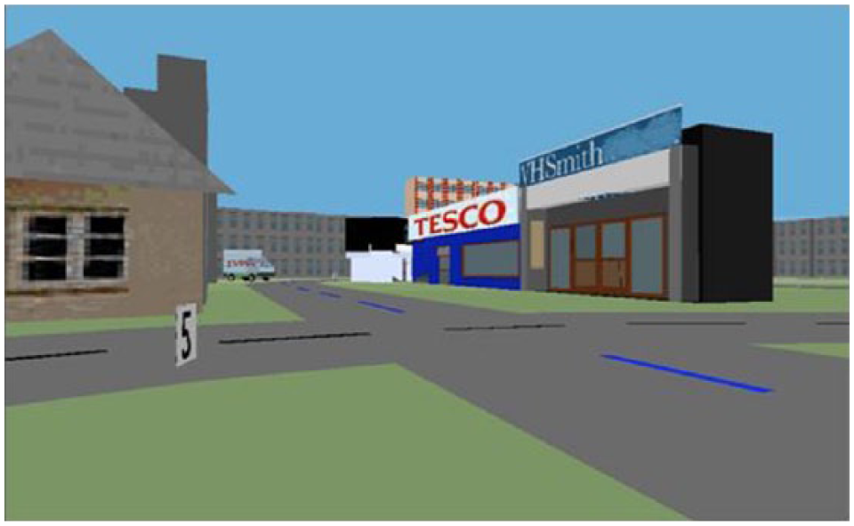
Screenshot of a junction in the virtual environment.
Procedure
Participants experienced the VE in either the active (driver) or passive (passenger) condition. Participants in the active condition were instructed that they would have 10 min to explore the VE and that within that time they must find four readily identifiable locations labeled variously as Home, College, Babysitter, and School, while also trying to “get to know” the layout of the VE, so that the learning task was explicit. The exploration of each active participant was videotaped and shown to the following participant who would therefore be in the passenger (passive) condition. Participants in the passive condition were told that they were viewing a 10-min tape of somebody “driving around” a VE and that they were to look out for four readily identifiable locations (the same locations that participants in the active condition were told to look for) while also trying to “get to know” the layout of the VE. At 5, 7, and 9 min, the experimenter asked all participants how many of the target locations they had found and informed them of the time they had left. Any participants who could not find all four locations within the 10 min allowed for the task could not proceed to the next stage of the experiment. This happened in only one instance.
Before being introduced to the experimental environment, all active participants were given instruction on how to use the input device and given the opportunity to “drive” around a practice virtual road circuit until they reported that they felt comfortable. Participants adjusted to the sensitivity of the controls in terms of turn and acceleration within the first minute and completed this task with ease. Importantly, Sandamas et al. (2009) found that prior experience of an input device to navigate a practice VE could restore the advantage on a map placement task for active explorers over passive observers, while without input device training passive participants were better (Sandamas & Foreman, 2007). They interpreted this as indicating that untrained use of the input device excessively loads working memory and acts as a concurrent task interfering with the main task of learning the layout of the test environment. This interpretation was given further support by the findings of Sandamas and Foreman (2014).
Outcome Measures
After experiencing the VE, measurement of participants’ spatial knowledge acquisition was designed to evaluate both survey and route knowledge as per Siegel and White’s (1975) model of spatial learning.
Survey mapping, street-level view
Pointing error (PE) scores
Participants were required to point to unseen locations from a central point within the VE by aiming a cross hair in the center of the screen at the target. This was achieved by rotating the viewpoint. The locations were those four that participants were required to look for during the exploration phase, plus one other that was highly visible (a red statue). PE scores were calculated from the cumulative difference between the true direction of the targets and participants’ indicated directions, measured in degrees. The scores were summed and divided by 5 to give mean scores for PE (see Table 2; see also Foreman, Stanton, Wilson, & Duffy, 2003; Sandamas & Foreman, 2007; Stulpnagel & Steffens, 2012).
Descriptive Statistics for Condition by Driver Status (n = 34).

Survey mapping, bird’s eye view
Map placement error scores
Each participant was given an A4 sheet of paper with the road layout of the VE printed on it and asked to indicate as accurately as possible, by marking the paper with the corresponding numbers, the positions of the four locations they were asked to find during the exploration phase of the study. Placement error scores were then calculated by measuring distance in millimeters between the positions indicated by the participants and the true location positions. These distances were summed for the four locations and divided by 4 to give mean scores for map placement error (MPE; see Table 2; see also Sandamas & Foreman, 2007; Sandamas, Foreman & Coulson, 2009).
Route knowledge
Route scores
Participants were required to travel via the shortest route between four pairs of locations within the VE; the locations used were those participants were required to look for during the exploration phase. The start point of each route was adjacent to one of the locations. Participants were “transported” directly to the start point and instructed to “drive” via the shortest route to the target location. Participants had to make four such journeys (college to home; home to the red statue; red statue to the baby sitter; baby sitter to the school). Participants’ displacements during this task were recorded and subsequently scored using the following criteria: 0 points for failing to reach the target location within the permitted time; 1 point for indirectly (doubling back, retracing steps, etc.) finding the target location; 2 points for finding the target location directly (no doubling back or retracing steps) but not via the shortest route; and 3 points for finding the target location directly via the shortest route. Participants’ points were totaled to give overall “route scores” (max: 12 points).
Results
The independent variables used in the following analyses were “condition” (active/passive) and “driver status” (whether or not participants were real-world car drivers). The dependent variables were PE scores (in degrees), MPE scores (in millimeters), and route scores.
Descriptive Statistics
Table 2 shows PE scores (in degrees), MPE scores (in millimeters), and route scores for condition by driver status. Inspection of the means indicates a trend in favor of drivers on all measures under all conditions except for route scores under the passive condition.
Inferential Statistics
The scores in Table 1 were subjected to a 2 (condition [active/passive]) × 2 (driver status [Driver/Non-Driver]) independent groups factorial ANOVA.
A significant main effect for driver status was indicated for MPE scores, F(1, 30) = 4.933, p = .034,

Map error by condition and driver status.
From Figure 3, we can see, from the lower MPE scores, that drivers are more accurate at placing landmarks on a map of the VE regardless of the condition (active/passive) than non-drivers.
A significant interaction for driver status by condition was indicated for route scores, F(1, 30) = 8.981, p = .005,
From Figure 4, we can see that real-world drivers in the active condition achieved higher, but not significantly so, route scores than all other participants.

Route scores by condition and driver status.
Correlation analysis revealed a significant negative relationship between route scores and MPE scores, r(32) = −.42, p = .01, indicating that participants who were better at navigating routes between landmarks in the VE, obtaining higher route scores, were also more accurate at placing the landmarks on a map of the VE, obtaining lower MPE scores. However, performance on PE scores did not correlate with either route or map MPE.
Discussion
The first experimental hypothesis, that active vehicle drivers would learn more about the spatial layout of the VE than passive observers, was not supported. Passive participants performed at the same level as their active counterparts when pointing to currently non-visible locations within the VE, identifying the positions of locations on an outline map of the VE and driving routes within the VE. The current findings, therefore, demonstrate that, for adults at least, activity in a VE does not necessarily confer an advantage for spatial learning of that environment, supporting the findings of many previous virtual world studies (e.g., Arthur, 1996; Gaunet et al., 2001; Sandamas, 2007; Sandamas & Foreman, 2007; Wilson, 1999; Wilson et al., 1997; Wilson & Peruch, 2002). Clearly, whether an active advantage does appear, as in studies such as those of Farrell et al. (2003), Hahm et al. (2007), and Wallet et al. (2010), may depend upon factors including the nature of the input device and the degree of training with which participants are provided prior to beginning the virtual exploration. Further specific study of these factors is needed. Moreover, age effects might be anticipated as studies such as those of Siegel, Herman, Allen, and Kirasic (1979), Feldman and Acredolo (1979), and Herman (1980) and the virtual experiments of Sandamas and Foreman (2007) have all indicated that as humans progress from childhood to adulthood they become less reliant on self-guided locomotion through space to form good spatial representations. Sandamas et al. (2009), however, did find that 7- to 8-year-olds were able to demonstrate the benefits of activity within a VE after initial training with the input device.
The current findings are inconsistent with the conclusions of many real-world environmental studies including those of Appleyard (1970), Hart (1981), Hart and Berzok (1982) who have argued activity to be beneficial for spatial learning in adults, based on the performance of real-world drivers compared with passengers. However, it should be noted that these former studies were not controlled experiments per se, but rather ecological/urban studies (Appleyard, 1970; Ladd, 1970) or theoretical review papers (Hart & Berzok, 1982; Siegel & White, 1975). Although Appleyard (1970) found car drivers to be better able to draw coherent city maps than bus passengers—and this has been often cited in subsequent papers as demonstrating the benefits of activity—it is unclear whether this reflects the benefits of activity per se (i.e., the physical act of driving and/or the mental act of making directional choices) or whether it arises because they get to experience more of the city that they are free to explore at “geographic” scale. In the current study, this confound was addressed as both active participants (who drove around the VE using the input device) and passive participants (who did not have any control over exploration) experienced the environment to the same extent; yet in this case, no differences in spatial learning emerged. Another advantage for drivers in the real world is that the act of driving itself forces them to attend more closely to where they are going and anticipate the routes they need to take (Chrastil & Warren, 2012). This means that environmental features such as street names, road signs, potential landmarks, distance, and directional information carry more importance for the car driver than for the casual passenger (see Beck & Wood, 1976). However, were passengers to attend to the environment during journeys to the same extent that is mandatory for drivers, their spatial learning could be equivalent to, or even greater than, that of drivers as they are not distracted by performing the concurrent task of physically driving. In the current study, both active and passive participants were given the same instruction to “get to know” the environment to attenuate any differences in attention between the groups, and no differences in spatial learning were found.
It might be suggested that the findings of previous real-world research, such as those of Appleyard (1970) and others (see above), may not reflect the benefits of activity per se but rather demonstrate benefits related to driving and consequent superior processing of spatial information. The current findings go some way to supporting this notion in that we did find a clear advantage on the map placement and route measures of spatial learning for participants who were car drivers in the real world. For instance, car drivers were significantly better than non-car drivers at indicating the positions of target locations on a map, regardless of the active or passive condition in which they participated. Previously, Beck and Wood (1976) suggested that experience with conventional maps predicts the ability to use maps as a vehicle for the expression for geographic knowledge, and Appleyard (1970) found that drivers drew maps that were more complete and coherent than those of passengers. Sandamas and Foreman (2007) found that greater experience in a VE led to better survey maps of the VE irrespective of the active or passive status of participants, although real-world driver status was not considered and this could have been a factor. Therefore, the current finding may be taken to demonstrate that car drivers have a greater understanding of, and ability to use, maps or they have developed other skills through driving which they are able to transfer to the understanding of new environments under a range of conditions including that of experiencing them passively.
It was also found that real-world car drivers in the experimental active condition were better at navigating routes within the VE than non-drivers in the active condition and car drivers in the passive condition. As the input device used in this study was a steering wheel, for directional control, paired with a set of pedals to control acceleration and braking, the situation closely replicated the experience of driving a vehicle with which drivers were all familiar. Real-world car drivers in the active condition may have benefited more, in terms of spatial learning, because they were able to explore the VE by driving round it, consistent with their experience in real life. Added to this, it could also be argued that real-world drivers using an input device that replicates driving are probably better able to adapt to—and less likely to suffer any cognitive disadvantage such as reduced working memory capacity from—this imposition than are non-drivers, as for child participants (Sandamas & Foreman, 2007; Sandamas et al., 2009). Furthermore, Foreman, Sandamas, and Newson (2004) did not find any advantage on a distance estimation task for participants who used a step device to “walk” around a VE over participants who experienced the VE actively, with a joystick or passively; virtual distance underestimation was consistent across groups.
The current study has also revealed a significant negative correlation between route scores and MPE scores indicating the interdependent relationship between survey and route knowledge and that these two aspects of spatial learning appear to develop fairly quickly and in parallel as proposed by Montello (1998) rather than in a strictly hierarchical way over an extended period of time, as proposed by Siegel and White (1975). Sandamas and Foreman (2004) also found that memory for landmarks and map drawing ability were positively correlated after brief experience of a VE. Interestingly, PE scores did not correlate with either of the other two measures of spatial learning in the current study or differentiate active/passive or driver/non-driver groups. The implication may be that the participants found the task too difficult and were unable to orient themselves within the VE, despite being able to navigate around it and place landmarks on a map of it. In addition, this finding may further illustrate the sensitivity of spatial learning to procedural, task, and measurement differences as pointed out by Wilson (1999), Chrastil and Warren (2012), and others, and therefore needs further investigation.
Obviously, the current findings raise many questions and research opportunities regarding the status of activity for spatial learning in adults, the role driving has to play in the development of specific spatial skills related to road-dominated environments and maps, and how best to use VEs in the future for transport and training, also the assessment of age-related driving competences (Pick, 2010; Ponds, Brouwer, & van Wolffelaar, 1988). The data also emphasize that driver experience is an important criterion that should be taken into account when sampling participants for participation in spatial experiments. Furthermore, driving and navigating should be regarded as representing competing “dual tasks,” especially for novice drivers; driver status is therefore a factor that should be incorporated in future into statistical analyses of any spatial learning data.
Footnotes
Declaration of Conflicting Interests
The author(s) declared no potential conflicts of interest with respect to the research, authorship, and/or publication of this article.
Funding
The author(s) received no financial support for the research and/or authorship of this article.