
Abstract
This article presents a mixed-methods research protocol suitable for studying everyday mobility and its effects on life chances for a wide range of populations. We argue that it can address, among other issues, two important methodological challenges in the study of mobility: addressing pre-reflexivity and habits, as well as differentiating between voluntary and forced movements. The research protocol combines a problem-centered interview, two weeks of GPS tracking, and a subsequent mobility interview. It has been shaped by its application to more than 60 socially disadvantaged residents of rural peripheries as part of an international research project. It contributes to existing qualitative methods of spatial analysis because its design incorporates not only theoretical considerations but also insights of real-world application from conducting it in varied contexts and with different populations, which are typically underrepresented in more elaborate research designs. Nevertheless, due to its thematic openness, the design is not only interesting for mobility research, but also for other research focusing on spatial phenomena at the individual level. We provide a detailed account of the method’s implementation, contextualize it in relation to previous approaches, and discuss the analytical potential of the data obtained. We suggest that by triangulating movement data with interview data, perceptions and meanings of everyday mobility can be uncovered that would otherwise remain at a pre-reflexive level.
Keywords
Introduction
Everyday mobility is a basic condition for social participation (Cass et al., 2005, p. 540), and mobility-related disadvantages can lead to social exclusion (Social Exclusion Unit, 2003). Previous research on the conditions and consequences of mobility at the individual level has mainly involved non-disadvantaged persons willing to participate in elaborate research designs. However, the individual mobility of those most likely to experience mobility-related disadvantages has not been explored in-depth in traditional transport surveys, presumably due to self-selection biases (Lucas et al., 2018, p. 632). Furthermore, the seemingly mundane places and encounters that occur in people’s everyday lives and shape their life chances have received little attention so far (Spenger et al., 2023, p. 2).
The following presents an innovative mixed-methods research protocol for studying everyday mobility and its effects on life chances among various populations. It was developed in an international research project that focused on how socially disadvantaged individuals cope with everyday life in spatially disadvantaged regions with limited opportunity structures (Bernard et al., 2023; Keim-Klärner et al., 2021). The protocol examines the fleeting nature of everyday mobility while minimizing participant demands using two qualitative interviews and two weeks of GPS tracking. By building on previous approaches and addressing their empirical shortcomings, we aim to contribute to the emerging body of mobility research that combines spatial and qualitative methods. The originality of this study lies in the applied combination of GPS tracking and qualitative interviews with members of socially disadvantaged groups, which has rarely been reported before. The article thus shows not all that is methodologically possible, but what is actually applicable to the study of the role of mobility in everyday life.
Background
A central theme of mobility research is that the extent of individual mobility does not necessarily indicate to what extent people are disadvantaged or the impact of mobility on their living situations: “Simply put, people may be travelling more because they want to (as evidenced by the income effect) or because they are obliged to (as evidenced by the presence of children in a household)” (Lucas et al., 2016, p. 168). This is why even big data sets on human movement allow only limited conclusions or can be highly misleading (Kwan & Schwanen, 2016, p. 252). Hence to investigate the meaning of mobility, qualitative methods are crucial. For this reason, scholars have combined travel data with subjective perceptions. For instance, Kamruzzaman and Hine (2012, p. 106) utilized a combination of travel-activity diaries and qualitative interviews. However, their qualitative data originated from group discussions in which the participants did not necessarily comment on their individual mobility experiences. A further difficulty of using travel-activity diaries lies in the imprecise temporal and spatial information provided by the respondents (Kwan & Ding, 2008). Another approach to explore the role of mobility in everyday life can be to focus not on movements, but on the places visited, as outlined by Spenger et al. (2023) in their research design for mapping places of encounter. Not only can spatial information be collected more precisely in this manner; as the authors point out, accidental encounters in particular have been given rather little attention so far, although their supposed mundaneness can make a significant contribution to the extent of individual life chances (cf. also van Dülmen & Klärner, 2022). While this approach illustrates that mobility is not only about transportation, it may overlook the ways in which individuals move between these places and the difficulties they may encounter in doing so.
Other scholars have used walk-along interviews. Jones et al. (2011) demonstrated that recording movement data during walk-along interviews using the Global Positioning System (GPS) opens up new analytical possibilities. Martini (2020) proposed another approach to combining data from interviews and geographic information systems (GIS). Although this approach showed considerable sensitivity to the interviewees’ everyday spaces, with interviews lasting up to 10 hours, no movement data were collected outside of this short, artificial research context. Furthermore, the data collected contained only a very limited range of everyday spatial actions (e.g., a 50 ha area in Jones et al., 2011, p. 180). Moreover, the single data collection instance may result in inadequacy in connecting mobility as a social phenomenon with other daily practices and the biographies of the respondents. An approach to address this shortcoming, as proposed by Seetharaman et al. (2023), is to integrate a walking interview among additional interviews. This procedure enables a more accurate understanding of the significance of mobility for individual life situations. However, also in their protocol the recording of places is limited to the spaces crossed during the walking interview.
By having respondents wearing a GPS tracker, this spatial limitation can be circumvented. To investigate the influence of suburban environments on active aging, Zeitler et al. (2012) and Zeitler and Buys (2015) used GPS tracking to record the daily mobility of elderly individuals. They drew on a combination of travel diaries, short questionnaires, GPS tracking for seven days, semi-structured interviews, and residential characteristics collected by external sources. Their mixed-methods design allowed for greater exploratory depth and for hypothesis-driven analysis. Nevertheless, whether this research design is applicable to other social groups, other spatial contexts, and larger case numbers is unclear. The small number of respondents (n = 13) recruited through industry partners may indicate the selection of respondents open to an extensive research design. Especially the capacity of participants to express themselves requires careful consideration when planning the research design and is an integral aspect that Marcotte et al. (2022) highlighted in their study of walking interviews with autistic people. Using a similar design as Zeitler and Buys (2015), Meijering and Weitkamp (2016) also found that some respondents were overburdened by keeping travel diaries and carrying trackers simultaneously. By successfully tracking n = 80 homeless people in Prague and Pilsen (Czechia), Šimon et al. (2020; 2019) showed that the other simultaneous requirements, rather than the GPS tracking itself, are the critical components of such a study design.
In the basal design of our mixed-methods research protocol (hereafter “protocol”), we build on the research design of Meijering and Weitkamp (2016); Šimon et al. (2019, 2020); Zeitler et al. (2012) in many respects. However, we propose key variations that make our study better suited for examining socially disadvantaged groups, and for exploiting the analytical potential of combining quantitative and qualitative methods.
Combining GPS Tracking Data with Qualitative Interviews
The presented protocol was applied to over 60 socially disadvantaged participants in the project Social Disadvantage in Rural Peripheries in Eastern Germany and the Czech Republic (Keim-Klärner et al., 2021). Participants were selected from three groups with an increased vulnerability to social disadvantage: (1) elderly people living independently for at least one year; (2) individuals who are disadvantaged in the labor market, such as those with lower educational status, disabilities, and chronic illnesses; (3) single parents living with at least one child under the age of 14 (for details on sample characteristics, see van Dülmen et al., 2022). All participants provided written informed consent.
The protocol consisted of three modules: an initial qualitative problem-centered interview (Interview 1), a two-week GPS tracking, and a subsequent semi-structured mobility interview (Interview 2). It was developed in response to the call to take seriously people’s mobilities as they occur in their lifeworlds (Merriman, 2014, p. 169). The resulting database was highly integrated, since the modules built upon each other and were integrated on three different levels. First, all modules were linked to each respective interviewee. Thus, different methods were integrated through their connections at the sample level (Fetters et al., 2013, p. 2139), which enabled a gradual broadening of our understanding of the mechanisms that perpetuate, reinforce, or mitigate social disadvantage. Second, at the study design level, an integrated convergent approach was used. Data were collected at different points in time to allow for interactions between various data types, which provided a more comprehensive picture of a complex topic (Creswell & Plano Clark, 2018, p. 74). In our protocol, the GPS data served as narrative stimuli for Interview 2 (mobility interview). Third, integration also occurred at the method level through building, as the results of one method informed the data collection procedure of the other method (Fetters et al., 2013, p. 2140).
Interview 1: Problem-Centered Interview
The first semi-structured qualitative interview is problem-centered (Witzel & Reiter, 2012), and the focus of the interview guideline can be set depending on the overarching research interest. Interview 1 focuses on a specific research question that is linked to the everyday problems of the interviewees, and that has relevance for the interviewees themselves. In our project, we asked the respondents about their everyday life, job, health, finances, education, and social ties (see Appendix: Guideline Interview 1 for details), as we were interested in exploring how they coped with everyday life in spatially disadvantaged regions with limited opportunity structures (Bernard et al., 2023; Keim-Klärner et al., 2021, p. 30). Each Interview 1 lasted between 43 and 164 minutes (mean = 98, median = 94 min.). Interview 1 provided valuable insights into the interviewees’ life situations, and should be considered a key module because it served to establish a basis for trust; that is, rapport (Grinyer & Thomas, 2012). Furthermore, the participants were informed at the end of interview 1 about the possibility of participating in the GPS tracking and the subsequent interview 2. If consent was given, the tracker was handed over directly after interview 1 (for briefing details, see section 3.2.1).
GPS Tracking, Data Processing, and Map Creation
The GPS tracking module was divided into three steps. During all steps, the team members could access data quickly using open source software.
Collecting GPS Data
Participants were given GPS trackers (Model: Qstarz BT-Q1000XT) and received an in-person briefing on how to use them. They were instructed to carry the device with them whenever they left home, to never turn it off, and to charge it every night (for helpful tips on participant compliance, see Kerr et al., 2011). The trackers were previously set to not go into sleep mode, the sound was turned off, and the recording interval was set to 10 seconds. The enclosed information sheet provided basic handling information, which was reiterated during the in-person briefing. On the back of this sheet was a form to record any device malfunctions or instances in which it was forgotten, and three cell phone numbers of the team members. Participants also received a charger, a case for safely transporting the device, and a pre-stamped envelope for returning the device to the researchers after 15 days (the return date was noted on the envelope). None of the more than 60 participants lost a tracker.
Although the use of smartphones has increased sharply in recent years, we opted against using an app because it would have excluded too many of our respondents (especially older people and those in poverty). Moreover, in a test phase with an app, the data quality was inferior to that of the standalone devices. Furthermore, the respondents perceived the standalone devices as more legitimate and as less intrusive than an app installed on a personal device.
We chose a tracking period of 14 consecutive days, since previous studies reported that their seven-day recording periods were too short to detect routines or to be representative of an individual’s everyday life (Kestens et al., 2018, p. 7; Meijering & Weitkamp, 2016, p. 205; Milton et al., 2015, p. 132). Stanley et al. (2018) identified a two-week period as the minimum duration required to capture a person’s spatial routines and the places the person visits regularly.
Processing GPS Data
After the trackers were returned, we processed the data. First, they were trimmed to actual tracking start and end times. This was followed by algorithmic processing using DBSCAN clustering, which was done using R 3.6.0 (R Core Team, 2023), the sf (v0.9–4; Pebesma, 2018), and dbscan (v1.1–5; Hahsler et al., 2019) packages. Clustering the raw GPS data allowed for the automatic identification of places where the participants spent time. Based on different thresholds suggested in the literature (Kerr et al., 2011, p. 536) and practical experience, it was established that 180 seconds produced the best results. The output of this processing was three shapefiles for each tracking day: one containing the identified places with arrival and departure times, one containing the paths traveled (trips) with speed information between the recording points, and one containing directional arrows for trips.
Creating Maps of Daily Mobility
In a third step, daily mobility maps for Interview 2 were created from these shapefiles. Using the open-source GIS QGIS (QGIS Development Team, 2021), the shapefiles were loaded as layers into a prepared template. The graphical elements were participant ID, day of the week, date, consecutive daily map numbering, and a scale (Figure 1). The background was a black-and-white map that was slightly transparent to allow for handwritten notes during Interview 2. As our experience indicated that street names were important orientation aids for respondents, we ensured that they were visible when discussing single places on a large scale (Figure 1(b)). Places were displayed as yellow dots, with the respective arrival and departure times serving as labels. The travel speed was indicated by gradual coloring, which provided the interviewer with information about the likely mode of transportation. Mobility maps as the product of GPS tracking and stimulus for Interview 2 (A: Daily overview map; B: Detailed map for one place with pre-researched annotations); source: own test data.
One overview map was created for each day (Figure 1(a)). Subsequently, detailed maps of the individual places visited during the day were created (Figure 1(b)). Maps were exported chronologically in a format and resolution printable on A4 paper. Each map was printed on a single A4 page. They were then pre-researched, ideally by the researcher conducting Interview 2, who chronologically numbered (with day of the week, date, and number of the map for that day) and annotated the possible activities being undertaken at each place (Figure 1(b)) using information from freely available databases (Open Street Maps, Google Maps) and knowledge gained from Interview 1. These annotations both helped the interviewee recall their mobility during the interview and prepared the interviewer by enabling him/her to set individual focal points within the guideline and to be able to navigate the sometimes extensive map sets with confidence. Depending on the extent and variability of the respondents’ mobility, the map sets contained between 19 and 66 maps (mean and median = 41), which is comparable to the number of maps in Bell et al. (2015, p. 89). This thorough preparation for Interview 2 was not optional, but mandatory. It significantly contributed to turning a potentially structured Interview 2 into a semi-structured one by encouraging interviewees to relate topics from Interview 1 about their general life situation or specific problem areas in their everyday lives to their mobility (see next section).
Interview 2: Mobility Interview
Using the previously created maps as stimuli, the second interview followed each interviewee’s mobility chronologically, day by day. A standard set of questions was repeated for each day’s trips and places visited (see Appendix: Guideline Interview 2). Ideally, the same interviewer conducts both interview 1 and interview 2 to take advantage of the rapport established in Interview 1 and to be able to incorporate the knowledge already gained about the interviewee’s life situation (structure of everyday life, significant others, domains of concern) into Interview 2.
Although Interview 2 had an overall structured framework, we consider it to be semi-structured because the open-ended questions allowed respondents to provide longer narratives and emphasize important features of a place or trip. By maximizing the interview’s qualitative orientation our protocol gave the interviewees greater scope to determine the individual meaning of places and trips, which in turn opened up “possibilities to deepen knowledge on the everyday geographies of mobility” (Meijering & Weitkamp, 2016, p. 205).
During the interview, the interviewer annotated unidentified places mentioned by the respondent, the actions undertaken there, the routes, the means of transportation, and any accompanying persons (see Figure 2). This step-by-step approach was critical to avoid making a priori distinctions between important and unimportant information. The interviewee was explicitly encouraged to reflect on supposed trivialities and mundane events. The trips and places discussed once in the interview were given less attention when they occurred repeatedly (e.g., a daily commute). Nonetheless, the interviewer explicitly asked again about places that had already been discussed. Such places were discussed repeatedly during the interview, in part to avoid downgrading the relevance to everyday life of places that were visited daily, and in part because a single place in physical space identified by GPS tracking could have multiple meanings for the respondent. In such cases, a one-time inquiry about the place would provide an incomplete picture. For example, the interviewee may have visited a village community center to attend a weekly choir rehearsal on one day and to negotiate local political issues on another. Annotated mobility maps as result of Interview 2 (A: Daily overview map; B: Detailed map for one place with pre-researched annotations); source: own test data.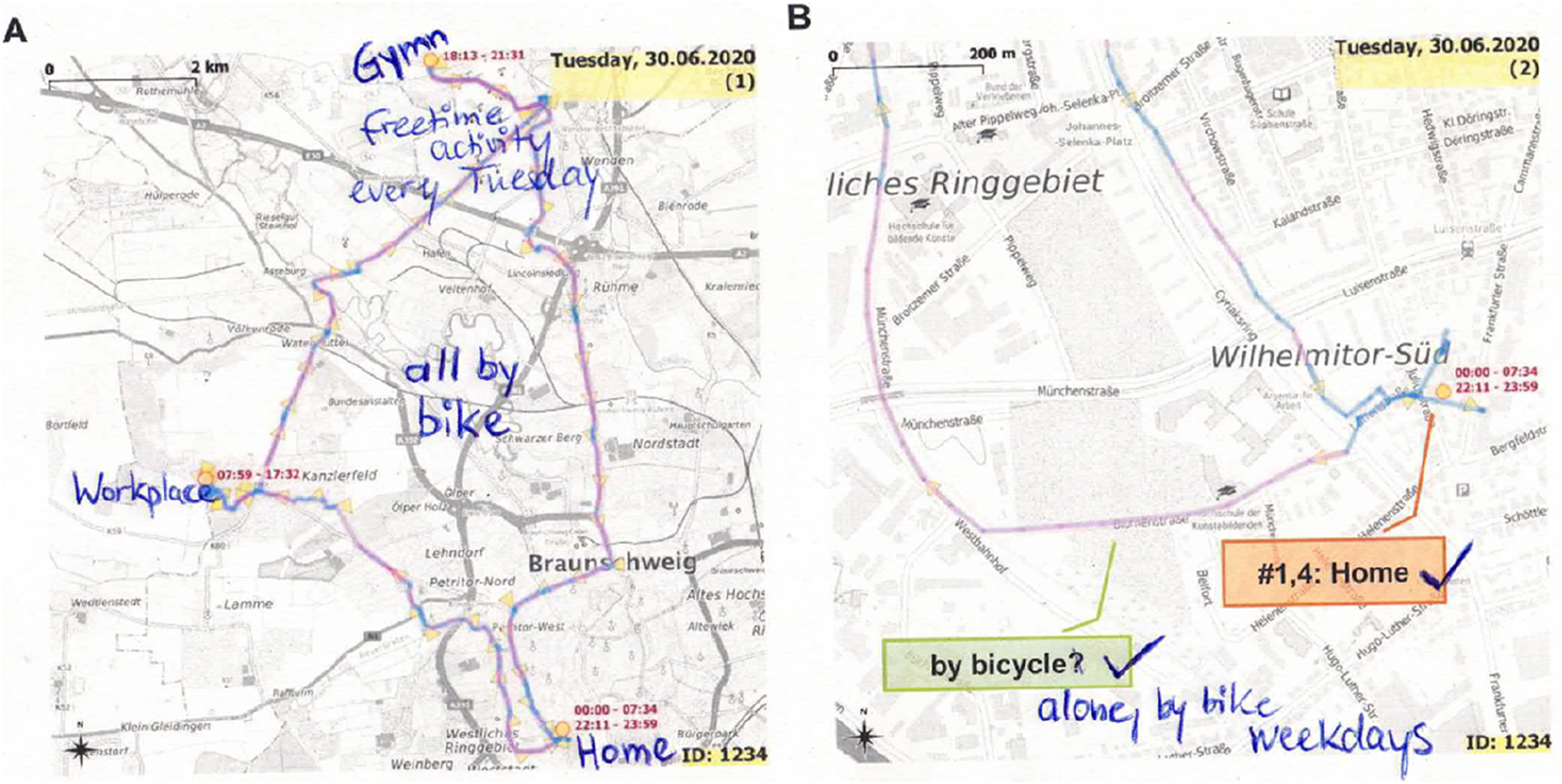
After the respondent was asked about his/her individual trips and the places s/he visited on a given day, s/he was prompted to reflect on the day as a whole (see Appendix: Guideline Interview 2). Here, the respondent was encouraged to abstract his/her daily mobility on a more general level in order to explore the significance and the degree of normality of that particular day. As the interviewee was given the opportunity to relate his/her own mobility on the day in question to the days previously discussed during the interview, the researcher did not have to pre-judge whether a day was or was not normal.
After discussing his/her trips and the places s/he visited during the two weeks, in a concluding set of questions, the interviewee was encouraged to reflect on his/her mobility situation in general, the interconnections between mobility and other areas of life, changes over the life course, and prospects for the future (see Appendix: Guideline Interview 2). Thus, Interview 2 collected information on both actual mobility and self-perceptions of “normal” mobility; two dimensions that Schmidt et al. (2018, pp. 107–108) discussed as “either-or.”
Interview 2 was conducted as soon as possible to fully utilize the interviewee’s memory capacity. On average, Interview 2 occurred one week after the last day of tracking. This interval allowed for the trackers to be returned by mail, the data to be processed, and the maps to be created and annotated. The duration of Interview 2 ranged between 74 and 147 minutes (mean = 109, median = 107 min.) and was dependent on the number of tracked activities per day. On days with no external activities, interview sequences could be as short as 1 minute. However, on days with complex movements or when interviewees were prompted by events to provide detailed narratives, the interview sequences for these days could easily take up to 20 minutes. The final set of questions regarding mobility could take anywhere from 3 to 20 minutes. The unspecified duration of the interview had to be accepted due to its open response structure and the interviewees’ varying ability to connect their mobility to their broader life situation.
Analytical Potential
In this section, we will demonstrate the analytical potential of the presented protocol by focusing on two methodological challenges that are repeatedly raised in transport and mobility research: everyday mobility as a pre-reflexive and habitualized phenomenon, and the distinction between voluntary and forced movements. We will also directly discuss the protocol’s strengths with related approaches.
Addressing Pre-reflexivity and Habits
As Meijering and Weitkamp (2016, p. 202) noted, the pre-reflexive, habitualized nature of many aspects of mobility makes it difficult to capture with methods that rely only on participants’ discursive expressions. Aspects the participants do not even consciously perceive or consider “too banal” or “too everyday” are not recorded or addressed. The presented protocol tackles this challenge by using the movements recorded over the two-week period as interview stimuli, thus keeping the level of abstraction very low compared to conventional survey or interview methods. Thus, the protocol can claim an advantage or standard that Marcotte et al. (2022, p. 5) also recognize as essential in their study with autistic people when discussing abstract topics (such as mobility): formulating “concrete and targeted” questions. Furthermore, like the GPS data, the semi-structured mobility interview did not distinguish between trivial and important events. As well as preventing the pre-selection of supposedly “important” events by the interviewer, as can occur when using pre-defined place categories as suggested by Spenger et al. (2023), it also encouraged the respondents to narrate in a more linear fashion, which aided subsequent analyses. Moreover, this approach led the respondents to reflect on events that would otherwise not be reflexively accessible to them in the interview situation; as the first half of the following passage illustrates: I (Interviewer): “And then you continued on foot, could it be that you then stopped again […] maybe at the Job Center?” R (Respondent): “Yes, yes, I was also in there, yes, hand in operating costs, man, now I also remember, yes. I: What’s it like when you go to the Job Center? B: Do you really want to know? I: Yes. Can you describe it, then you come in, what-. B: First of all, I get so mad. I get annoyed because there are foreigners standing in front of me again, yes, and I can't be bothered. MONEY, MONEY, MONEY, DON'T UNDERSTAND ANYTHING, MONEY.” (labor market disadvantaged man, aged 50)
The second half of the passage shows how the interviewee is granted a degree of openness by the interviewer that allows him to narrate in a way that is unexpected for the interviewer and not necessarily compatible with their system of interpretation, but with his own logic. We learn that the Job Center is not only the place where he has to hand over his operating costs, but that it is an everyday place that confronts him with a social self-positioning, insofar as he uses racist topoi to distinguish himself as a ‘legitimate’ recipient of transfer payments from people with a presumed immigrant background. However, this only became clear when the interviewer openly asked what it was like for the interviewee to visit this place. Exactly this is an example of the potential insights that come from the fact that participants were “asked to expand on each specific trip or place” (Meijering & Weitkamp, 2016, p. 205).
The consequences of not distinguishing between the seemingly unimportant and the important can be seen in the case of a single mother, who was commuting a long distance to work every day, and whose trips and working hours were highly routinized. At first, she did not think that these trips were worth mentioning to the interviewer. However, after being asked about the trips each time they appeared on the maps, the interviewee began to reflect on their supposed normality, and to notice how her commute and workplace were limiting her other life chances. Her economic constraints (which came up in Interview 1), coupled with the heavy time and energy demands of her job and commute, made it extremely difficult for her to change the disadvantageous living conditions on her own: R: “Well, actually they are all stressful days for me (laughs), because there is always so much work that you are so exhausted.” I: “And do you think something else will come up?” R: “Yes, I plan to do it every year, because as I said, financially it’s really not much here, but somehow, I can’t really get away from it, I’ve just settled in.” (single mother, aged 40)
By linking general narratives about the respondent’s own life situation from Interview 1 with concrete events over 14 days, we obtained a biographical and contextual embedding of the movement data. We can, therefore, confirm the efficacy of performing sequential interviews, as applied by Seetharaman et al. (2023, p. 7), in terms of establishing rapport and obtaining in-depth data. However, for our purpose, two interviews proved sufficient. Seetharaman et al. (2023) may have employed four interviews due to their research focus on individuals with dementia. Origins and intentions of mobility became easier to interpret against the background of life histories and structural conditions, and did not have to be limited to a simple explanation of the choice of means of transport, as is common in transport surveys (Manderscheid, 2014, p. 189).
Differentiating Between Voluntary and Forced Movements
As was mentioned in Section 2, assessing whether a person’s mobility improves his/her life chances is not possible using quantitative movement data alone, as whether the person’s movements or lack thereof are voluntary or forced remains unclear. While increased travel may mean that a person is optimizing his/her life chances, it could also mean that s/he is forced to move in ways that are contrary to his/her needs. The direction of causation between social disadvantage and mobility, as well as other potential exogenous influences, are intensively discussed in transport research (Lucas et al., 2016, p. 168). This protocol can make an important contribution to this debate by contextualizing the respondents’ concrete mobility (Interview 2) within their general life situation (Interview 1).
For example, the GPS data of the following elderly respondent showed regularly recurring trips to a pharmacy over the 14 day period (Figure 3). An interpretation of her mobility based on movement data alone might conclude that this lone woman’s health problems required her to make frequent, long trips to a distant doctor, and that these trips limited her life chances. The opposite was true: she voluntarily undertook the trips to get a prescription that could have been sent by mail in order to fill her daily life with activities, and hence to improve her life chances. Thus, by adding the respondent’s perspective to the movement data, Interview 2 can give meaning to detours and supposedly “irrational” spatial behavior. This example exemplifies the necessity of qualitative data in assessing the role of mobility in everyday life. Two-week movement pattern (each colored line represents one day; red dots represent automatically identified places) and interview passage on reasons for repeated pharmacy visits; joint display.
Conclusion and Outlook
Conducting mobility interviews – i.e., triangulating movement data with interview data – enabled us to uncover perceptions and meanings of everyday mobility that would otherwise remain at a pre-reflexive level, and to analyze their significance for individual life situations.
The mobility interview protocol builds on previous approaches, primarily gerontological or social geographic, that used GPS tracking to collect movement data. However, it makes greater use of the potential of interviewees’ subjective perspectives by conducting a prior problem-centered interview and by keeping the interview as open as possible. By structuring the mobility interview using the movement data, this approach shares the methodological orientation of walk-along interviews, which also focus on the experience of the spatial situation from the interviewee’s point of view. However, by basing the mobility interview on two-week movement data, a much larger part of a person’s everyday mobility can be examined than in most walk-along interviews, and without falling back on generalizing statements, as would be the case in purely qualitative interviews. By adding the maps of daily mobility in Interview 2 spatial routines could be explicitly addressed. Repeated movements were frequently mentioned due to the chronological sequence, which prompted interviewees to reflect on the significance of their movement patterns for their daily lives and life chances.
From an ethical point of view, it must be noted that the high resolution of the movement data makes it possible to gain intimate insights into respondents’ everyday lives. Possible implications have already been discussed elsewhere (e.g., Breslin et al., 2019; Propen, 2006). However, for publications, the raw GPS data were either aggregated into activity space metrics or projected without a background map, making the tracked individuals unidentifiable (e.g., van Dülmen et al., 2022). By using stand-alone devices, we had full control over the data throughout the process and participants could be sure that they would not be tracked in real time. Additionally, through the trust-building Interview 1 and the subsequent explanation of the tracking procedure, respondents were aware of what data were recorded and for what purposes.
In addition to its strengths, the protocol presented here has limitations. First, while providing valuable data, GPS trackers have shortcomings. Especially in densely built-up areas, signal errors can occur, resulting in implausible coordinates (e.g., Jones et al., 2011, p. 183). Furthermore, only movements outside buildings can be recorded. Thus, movements within the home, which are often a concern for the elderly or those with physical limitations, are not reflected in the data collected. However, this technically determined definition of movement is by no means objective, and should be critically reflected upon during the analysis. Second, places that are not visited during the tracking period, even if they are important in the respondent’s everyday life, are significantly less likely to be the subject of the mobility interview. Place-oriented approaches such as those of Spenger et al. (2023) could be an important complement here. Third, interviewing persons with reduced vision or cognitive impairments can be challenging because they may have difficulties orienting themselves on the presented maps. As map reading is a presuppositional skill, interviewers should expect to have to help respondents repeatedly to orient themselves on the maps. Fourth, in agreement with Bell et al. (2015, pp. 94–95), we can confirm that the protocol involves a considerable commitment of time and resources on the part of the researchers. Ideally, it takes about three weeks to carry out the methodology presented here. Moreover, considerable coordination is needed when tracking several respondents simultaneously. We found it useful to divide the individual steps (preparing the devices; processing the raw GPS data; creating the maps; conducting the interviews; etc.) among the specialized team members. Overall, we think that the potential of the approach more than outweighs its costs and limitations.
In this paper, we have demonstrated how the mixed-methods protocol can reveal the significant role of everyday mobility in the (re)production of social inequalities in spatially disadvantaged regions with limited opportunity structures. We believe that this protocol can serve as useful tool for addressing various other questions in the social sciences and for studying the spatial behavior of other, often marginalized groups, including refugees, sex workers, persons with disabilities, and LGBTQ + individuals. A major analytical strength of this approach is that because of the structure the GPS data provides, it enables comparative perspectives, including cross-cultural research (Bell et al., 2014, p. 291) and research comparing different populations (Meijering, 2021, p. 715). Furthermore, the triangulation of findings from Interviews I and II allows for a perspective on everyday mobility that takes into account a person’s life trajectory (Meijering, 2021, p. 718), and thus enables, for example, research on the phenomenon of adaptive preferences. This means that people adapt their expectations and preferences to the limited opportunities around them, and therefore no longer perceive these limitations as such – a phenomenon that has been largely overlooked in the transport literature (Ryan & Pereira, 2021, p. 3).
Supplemental Material
Supplemental Material - The Mobility Interview: Triangulating Interview and Global Positioning System Data to Explore the Role of Mobility in Everyday Life
Supplemental Material for The Mobility Interview: Triangulating Interview and GPS Data to Explore the Role of Mobility in Everyday Life by Christoph van Dülmen, Martin Šimon, Susann Bischof, Josef Bernard, Sylvia Keim-Klärner, Anja Decker, Hana Daňková, Max Eysholdt, and Andreas Klärner in International Journal of Qualitative Methods
Footnotes
Acknowledgments
We are deeply indebted to all the individuals who were willing to participate in our study. We would like to thank Miriam Hils for language editing.
Declaration of Conflicting Interests
The author(s) declared no potential conflicts of interest with respect to the research, authorship, and/or publication of this article.
Funding
The author(s) disclosed receipt of the following financial support for the research, authorship, and/or publication of this article: This work was supported by the German Research Foundation [DFG; Project Number: 391073923] and the Czech Science Foundation [GAČR; Contract ID: 18–05704J]. The University of Hamburg’s Open Access Fund made open access publication possible.
ORCID iDs
Supplemental Material
Supplemental material for this article is available online. The guideline for Interview 1 should focus on the research question’s overarching interest. Thus, this guideline can only be exemplary.
References
Supplementary Material
Please find the following supplemental material available below.
For Open Access articles published under a Creative Commons License, all supplemental material carries the same license as the article it is associated with.
For non-Open Access articles published, all supplemental material carries a non-exclusive license, and permission requests for re-use of supplemental material or any part of supplemental material shall be sent directly to the copyright owner as specified in the copyright notice associated with the article.