
Abstract
The management of peri-urban development has emerged as a new context of contemporary urban planning. Its dynamic and diverse nature presents major challenges and opportunities for urban sustainability. However, a more integrated framework for peri-urban planning has been progressing slowly. An examination of the epistemology of the landscape concept reveals three salient aspects of landscape relevant to multiple domains of peri-urban planning – the unifying, morphogenetic and socialised. Although landscape research has translated into peri-urban management, its full potential has yet to be realised. Among the three landscape dimensions, morphogenesis is relatively neglected. By foregrounding morphogenesis, the three epistemological orientations of landscape can be rebalanced and reintegrated to form the basis of a new planning framework for more continuous, harmonious and sustainable peri-urban development.
Introduction
Urban transition in many countries has entered a new phase in which a considerable portion of urban population and territorial growth is happening at the outer urban extent (Friedmann, 2011; Leaf, 2016; Webster, 2002). The accelerated pace of change, especially in the developing world, is rapidly reconfiguring the characteristics of these peri-urban spaces made up of organic areas, historical traces, and modern compounds (Abramson, 2016; Buxton and Choy, 2007; Gallent and Shaw, 2007). Sustainable peri-urban development requires a close and positive human-nature relationship that is unachievable without concerted spatial and temporal coordination and management of changing urban, rural, and natural landscapes. Despite growing research interest, more integrated approaches to peri-urban planning have been slow to develop, and there is a pronounced mismatch between peri-urban research and practice.
Investigating the physical space around us has attracted researchers from a wide range of disciplines, including geography, planning and the social sciences. The landscape idea has a long history and profound theoretical values (Antrop and Van Eetvelde, 2017; Arts et al., 2017; Gregory et al., 2009). In the geographical tradition, landscape refers to an area or unit shaped by both natural and socio-cultural processes (Hartshorne, 1939; Sauer, 1925; Schlüter, 1899a, 1899b). The conceptualisation of landscape and the interrelationships of the objects that coexist in it give rise to a triad of epistemological orientations – the unifying, morphogenetic and socialised. The unifying nature of landscape connects the sciences and humanities as well as cultural and natural landscape components (Selman, 2012). Morphogenesis strives to disclose the ‘genesis’ of landscape forms and their ‘engendering process’ (Alexander, 2004). The socialised aspect of landscape is concerned with the relationship between humans and landscape and the ways in which the two sides are intertwined and mutually shaped (Arts et al., 2017; Davenport and Anderson, 2005; Egoz, 2012). These three perspectives are inextricably intertwined in the understanding of landscape.
Despite recent advances in the use of landscape research in planning and the management of peri-urban landscape changes (De Graaf et al., 2017; Peart, 2005; Turner and Gardner, 2015), its potential is yet to be fully realised. This is partly because morphogenesis is relatively neglected among the three landscape dimensions. The creation of landscape forms is deemed to be developmental or evolutionary. The morphogenetic process reveals the form of what is coming, or what is about to be, and is always drawn from the form at the moment just before. Future environments generated by morphogenetic processes, in which landscape elements act on each other to adapt cooperatively as a system evolves, will encompass the key technical, cultural, and social attributes of sustainability (Alexander, 2004). By foregrounding morphogenesis, the three epistemological orientations of landscape can be rebalanced and reintegrated for more accountable peri-urban planning.
This paper has two primary goals. One is to critically examine current planning research and practice for peri-urban spatial development; the other is to formulate a peri-urban planning framework that embodies geographical landscape thinking. It contributes to three key debates pertinent to contemporary peri-urban planning: 1) how to formulate an appropriate knowledge of emerging peri-urban environments embodying diverse functionalities and their spatiality; 2) how to re-establish and reinforce the landscape approach to peri-urban planning; and 3) how to strengthen peri-urban planning rationalities leading to high-quality planning outcomes. The multi-dimensional landscape concept provides both theoretical and practical bases for sustainable peri-urban planning. In particular, bringing unifying, morphogenetic and socialised perspectives to peri-urban landscapes is essential for the characterisation and assessment of the environmental and social performance of these spaces. Geographical landscape research is fundamental to planning for a more coherent and continuous peri-urban environment.
Peri-urban development and its management
Understanding and conceptualising complex peri-urban areas
It is vital to clarify what the peri-urban area is. Research interest in the transitional zone between the urban and the rural is not new (Leaf, 2011). Ford (1998) describes these areas as falling on an urban-rural continuum, along which areas become less urban and more rural moving from the urban to the rural end. The continual and uneven urbanising processes occurring in the peri-urban area have resulted in a struggle between urban and rural forces, contributing to the complexity that is a prominent feature of such areas. The peri-urban has thus become a vital locale for investigating and evaluating the effect of urbanisation, modernisation, and rural industrialisation on peri-urban activities and lifestyles (Lin, 2006).
Peri-urban areas can be specifically delimited to serve various purposes. For instance, to contain urban sprawl, the Auckland Council implemented the Rural-Urban Boundary which is a geographical delimitation that separates consolidated growth, including zones for continuous urban expansion, from undeveloped lands, satellite towns and farming areas (Auckland Council, 2012). According to McGee’s observation of Southeast Asian cities, the urban-rural continuum has five main components: central cities, peri-urban regions, desakota regions, densely populated rural regions, and sparsely populated frontier regions (Mcgee, 1991). Within the continuum from urban to rural, there is a gradient of decreasing population density and increasing agricultural intensity and the peri-urban and desakota are slightly different in terms of the proportion of urban and agricultural functions (Ginsburg et al., 1991).
Recent decades have seen an increase in the number of peri-urban studies seeking to conceptualise its complex nature using parameters such as remoteness, isolation, the degree of urbanisation and urbanity, and urban hierarchy (La Rosa et al., 2018). The majority sees the phenomenon of peri-urbanisation as a critical analytical point for observing urbanisation. For example, ideas such as Edge city (Garreau, 1992), edgeless cities (Lang and LeFurgy, 2003), and postmetropolis (Soja, 2000) capture multiple aspects of the new urbanity of peri-urban growth, conceptualising it through the lens of its urban nature. Peri-urbanisation, in some cases, includes a reinforced functional status. In North America, the term postsuburbia has been coined to describe the phenomenon whereby urban peripheries develop an economic life of their own (Lucy and Phillips, 1997; Phelps et al., 2010; Teaford, 1997). Some studies have taken a closer look at this autonomous characteristic of these territories and the strengthened role they play in an urban-rural structure. Zwischenstadt (Sieverts, 2003) denotes a final state of peri-urbanisation where peri-urban space evolves into an autonomous territory, which, from a functional perspective, is freed from its urban centre. Technoburbia, also stemming from North America, specifically refers to the growth of hi-tech industries in peri-urban districts (Fishman, 1987; Miao et al., 2019). Some researchers have also distinguished the spatial structure of this phenomenon. The spatial structure can include both location in an urban-rural system and the spatial expansion of these territories. The term interstices (Phelps and Silva, 2018) defines a part of urban sprawl where sections of the built environment and infrastructures mingle.
Peri-urban areas in developing countries in the transitional process of becoming urban have captured considerable research interest, especially since the 1980s (Dadashpoor and Ahani, 2019; Friedmann, 2011). Peri-urban areas around Asian metropolises in particular feature a rapidly-urbanising interface driven by industry and development policies. This peri-urbanisation process is mostly dominated by urban features, such as the spillover of urban population and production. These urban attributes are changing both the spatial and functional characteristics of the peri-urban environment. Webster (2002) specifies three key dimensions of the peri-urbanisation process – changing economic activities and employment, population growth, and spatial patterns. An additional less discussed but very important dimension could be peri-urban lifestyles or activities, which is also a way of defining urbanisation (Wirth, 1938).
The plurality of peri-urban development suggests the variety of peri-urban space and differing significance of peri-urban characteristics around the globe, but does not necessarily indicate a lack of transferability of peri-urban concepts and methods. For instance, desakota from the Indonesian context has been applied more broadly in Asia and terms arising from North America, such as postsuburbia and technoburbia, are now localised in hi-tech urban peripheries in both European and Asian cities (Guldin, 1996; Miao et al., 2019; Wu and Phelps, 2008). The intention behind conceptualising peri-urban phenomena relates to the changing spatial and structural characteristics and socio-economic transformations of the peri-urban landscape.
The physical characteristics of peri-urban areas are distinctive, displaying a heterogeneous mosaic of landscape type areas – ‘natural’, ‘productive’ or ‘agro-’, and ‘urban’ (Allen, 2003; Gonçalves et al., 2017; La Rosa et al., 2018; Wandl and Magoni, 2017; Webster, 2002; Zhao, 2013; Zhu and Guo, 2014). The geographical understanding of the peri-urban landscape and its components is shown in Figure 1. The investigation of peri-urban landscapes has a significant role and enormous potential in steering spatial planning and design towards more sustainable urban development (Wandl and Magoni, 2017). Tacoli (1998) suggests that when approaching an understanding of the peri-urban environment, the first thing is to recognise it as a brand-new context for urban-study enquiries. Not only are the scale and scope of urban transformation unprecedented, but the crisis of peri-urban space is a new trend, and the proposed solutions encompass an integrated perspective capable of both describing this growing spatiality and prescribing the proper treatment. An improved peri-urban landscape epistemology is the first step towards sustainable peri-urban development and transformation. The peri-urban landscape and its components.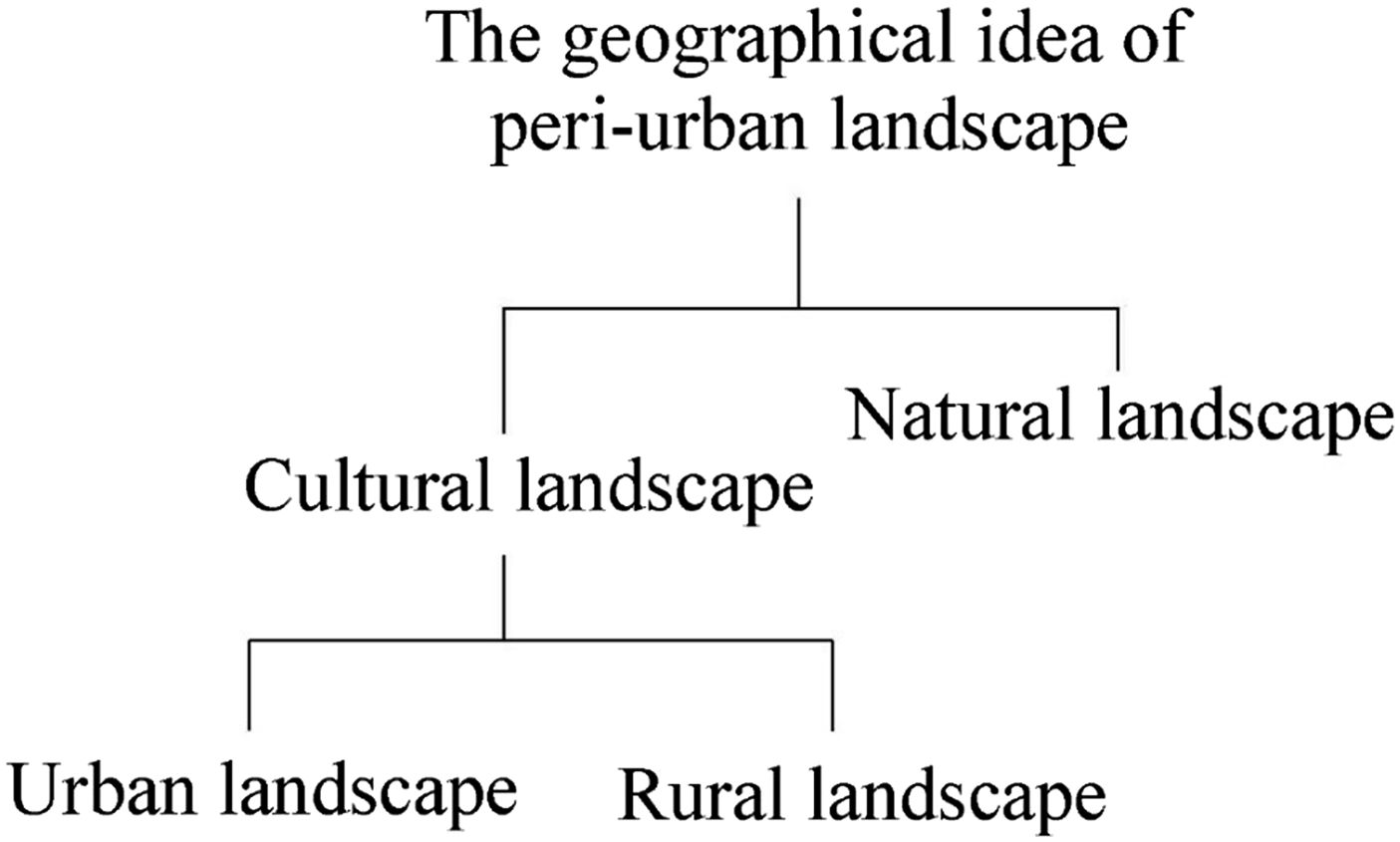
Peri-urban planning: issues and challenges
The organisation of peri-urban space is exceptional, characterised by its disconnected and fragmented arrangement (Gallent and Shaw, 2007). The public/private sector, national/local government, and collective/individual stakeholders are all involved, and its administration is a critical issue (Buxton and Choy, 2007; Rauws and de Roo, 2011; Scott et al., 2013). The sometimes uncoordinated objectives, fragmented management and inefficacious implementation in peri-urban areas worry researchers. Various forces, whether induced or autonomous, top-down or bottom-up, pushing or pulling, simultaneously shape and reshape the peri-urban landscape into a distinct type of space (Abramson, 2016; Rauws and de Roo, 2011; Wandl et al., 2017). Peri-urban areas typically transcend administrative boundaries and involve multiple departments, and this overlapping of power and power void further adds to discoordination in the administration of the peri-urban (Allen, 2003; Keil and Young, 2008; Tian, 2015). Indeed, Griffiths (1994) sees the peri-urban as “planning’s last frontier” for the unique type of space and peculiar predicament it represents for planning and administration.
It is essential to situate peri-urban transitions within a broader context. Peri-urban growth is not happening on its own; it is accompanied by a series of metropolitan transformations and urban dynamics (da Cruz et al., 2020). From a broader perspective, the dynamics of metropolitan growth are shifting too. Narratives ranging from the statistically significant yet contested judgement of the urban age discourse, to planetary urbanism (Brenner and Schmid, 2014, 2015), to Keil’s (2018) reminder that we now live on a suburban planet are all deeply engaged with evolving urban dynamics, and the complicated, divergent, and multi-dimensional currents of peri-urban transformation. Previous research and practice, though innovative and varied, reflects the need to cast the peri-urban in a different light. As Lerup argues in his insightful book The Continuous City (2017), “this binary way of thinking [of the city and suburbs] squandered the potential to see the urban materially” (p. 21). His collected essays open up possibilities for rethinking the urbanising process, reconsidering the peri-urban epistemology in a changing context, and tackling the urban-rural dichotomy directly and innovatively.
Peri-urban management is a challenging field that offers opportunities for experimenting with and validating urban planning and governance techniques (La Rosa et al., 2018; Qviström and Saltzman, 2006; Scott et al., 2013). The emerging “planning for peri-urbanism” narrative calls for a comprehensive and dedicated approach to this complicated yet promising context (Adu-Gyamfi, 2020). An integrated but also balanced peri-urban planning framework is needed to tackle these complicated and transitioning spaces. The efficacy of a new framework will rest on the following capabilities. First, it needs to provide insightful analytical approaches to comprehensively describe and accurately characterise the spatial heterogeneity of peri-urban landscapes and provide a bedrock from which to tackle peri-urban problems. Secondly, the framework will need to go beyond the traditional space-based perspective and incorporate a landscape-based view that looks at a more effective way of untangling complex peri-urban transitions. Thirdly, the framework needs to establish a lens through which to consider both the spatial and temporal changes of peri-urban areas. Local and contextual shifts, including spatial, socio-economic, and cultural changes, require careful consideration in order to extend the understanding of why and how the peri-urban transforms. This paper suggests a basis for peri-urban planning that harnesses the geographical idea of landscape emphasising generative processes and spatial characteristics and contributes to an integrated picture of peri-urban areas.
Recovering and strengthening the nature of landscape for planning
Consolidating a unifying view of the cultural and natural landscapes
The origins of the landscape can be traced to the Germanic languages, with lantscap in Dutch and landschaft in German referring to a piece of land (Antrop, 2012). The German form landschaft – combines land with schaffen (to make) – perhaps referring to the human activities involved in the making of the landscape. American geographer Sauer (1925) sees landscapes as systems connecting human societies and natural environments (Gregory et al., 2009). The landscape, especially in geographical thinking, is “an area of a distinct association of forms, both physical and cultural” (Sauer, 1925: 26). As European landscape architect Jorgensen (2015) further elaborates, the concept of landscape is holistic, describing where “social, biotic and abiotic environmental processes” are interconnected (p. 1).
Geographical approaches to landscape range from considerations of its natural and social dimensions to the arts and humanities. It is a broad conception encompassing terrestrial natural elements (mountains, forests, rivers, seas, and wetlands), socio-cultural components (human settlements, farms, industrial and historical heritage, and other forms of land uses), and political constructs (territories, borders, orderings, and functionalities), and connoting the mental and metaphoric meanings attached to the space (Minca, 2007). These various angles to landscape and their combinations have shaped different types of landscapes. Cultural and natural landscapes are clearly where the degree to which landscape is transformed by human activities and socio-cultural processes is addressed. With human impacts reaching the whole world, scholars are concerned that the distinction between cultural and natural landscapes has vanished (Antrop, 2017). Rural and urban landscape narratives come with an explicit mutual exclusion and opposition. The rural-urban divide and clear differentiation between habitancy and commerce are largely a political production. This binary is also blurred with the emergence of new complex and dynamic spatial typologies, such as urbanised rural landscapes, peri-urbanised and marginal landscapes, and ecological urban landscapes. Notably, it is not only areas with extraordinary features, such as heritage sites or landmarks, that are valuable in terms of landscape; rather, the ordinary landscapes of everyday life are also powerful and bear common but special bonds, communicating shared meanings attached to their specific context (Muir, 2000; Riley, 1992).
Awareness of the profound geographical meanings of the landscape concept maximises its potential for holism. The unifying perspective is what makes landscape a strong link between the material world (its natural and cultural components) and the various social and political constructs that accompany its evolvement. It unifies multi-dimensional natural and societal features and reflects them as an integrated and holistic whole. This holism also suggests the value of landscape’s wholeness is greater than the sum of its parts (Humboldt, 1845); the associations and systematisation of the parts reinforce landscape’s rich and distinctive characteristics. Landscape constitutes a whole evolving and interacting system that combines multiple perspectives. Sustainable and high-quality landscape development is not merely ecologically and economically viable and socially just, but additionally supports a continuous and integral form of space.
Morphogenetic thinking in landscape
The development of morphogenetic thinking in geography from the mid- to late-nineteenth century coincided with the increasing influence of Charles Darwin’s Origin of Species, published in 1859. The theory of evolutionary change became a useful analogy beyond its original application in biology and was adopted by geographers from other west-central European countries in the following decades.
The landscape itself is in a process of change, materially reflecting a history of human engagement (Aston, 1997; Crouch and Ward, 1988; Hoskins, 1955) and becoming what American geographer Sauer (1963) called a “palimpsest”—a layered and inscribed record of human activity in temporal and spatial terms: “We cannot form an idea of landscape except in terms of its time relations as well as its space relations. It is in continuous process of development or of dissolution and replacement” (Sauer, 1963: 333). Researchers subsequently began to consider how this material transformation, or ‘morphogenesis’, provides insights into cultural ideas and practices, leading Meinig (1979) to observe that “if we want to understand ourselves, we would do well to take a searching look at our landscapes”.
Taking his cue from nature, Christopher Alexander (2004) studied the processes of morphogenesis in biology and other natural phenomena, and the characteristic geometries that resulted, later transferring these observations to conceptualise landscape and urban development. The dynamic process of landscape is similar to that of cell growth in an organism, and it is this unfolding process that produces the landscape and its typologies. The emergence of a new structure in nature is always brought about by a sequence of transformations that act on the whole, and in which each step emerges as a discernible and continuous result of the immediately preceding step (Alexander, 2003: 19).
All landscapes, natural or cultural, are changing continuously in a process of morphogenesis, constantly forming and transforming, growing and adapting. The process of formation and transformation creates a wide variety of landscape features, directly influencing the characteristics that represent the distinct natural and cultural identity of an area. The processual analysis of the changing configuration of an area or region over time is at the core of landscape research. This morphogenetic orientation on landscape is not limited to the physical manifestation of the landscape form itself, but seeks to interpret the ‘genesis or engendering process’ (Kropf and Malfroy, 2013) of landscape forms.
Methods of articulating the spatial structures of landscapes that are fundamental to morphogenesis have considerable potential in planning. On the basis of the relationship between development conditions and the resulting spatial groupings of form elements, recognition of landscape type areas or landscape structural units is significant for landscape characterisation and assessment. A landscape type area is a unit of homogenous natural and cultural landscape forms. The structure of landscape type areas provides an overarching framework for articulating the detailed characteristics of these units. They can then be used as the basis for developing planning objectives and corresponding management policies for each unit. Rather than applying an abstract set of rules as in the traditional development control system, landscape-based planning is more specific to units. It is important to ensure that the meaning and integrity of the evolutionary approach are retained in the process of translating landscape research into planning policy. As the actual outcome of complex natural and socio-cultural processes, the landscape type areas embody local historical development and thereby provide an invaluable planning resource for improving the quality and character of the peri-urban environment.
The socialised value in landscape
German geographer Friedrich Ratzel (1844–1904) adapted Darwin’s evolutionary concepts to develop a systematic approach to studying how human groups are influenced by their physical environment, which he later termed “anthropogeographie” (Semple, 1911). Influenced by Darwin’s idea of “survival of the fittest”, Ratzel focussed on environmental influences and anthropogeographie came to mean bridging the connection between land and people. Ratzel posited that the principal thrust in historical geography is the way that human beings make changes to landscapes (Darby, 1951). He also performed a great service by providing a theoretical basis for environmental determinism (Vesentini, 2008). Thereafter, environmentalists set a high value on the influence of environmental elements and access to natural resources as determining factors in the development of cultural and racial traits.
The landscape holds intimate references for the people who use it (Olwig, 1996). The physical or tangible landscape interacts in a complex manner with the way it is perceived, experienced, and appreciated – “the psychology of landscape” as Jacobs (2011) calls it. The relationship between human societies and landscape and the way the two sides are intertwined and mutually shaped are valuable assets of the landscape. People perceive, identify, and comprehend their surroundings and “[p]lace incarnates the experiences and aspirations of people” (Tuan, 1979: 387). Not only does landscape represent local contexts and cultural identity, it also contributes to building and shaping areal, cultural, or individual identity (Egoz, 2012). It elevates the tangible and instrumental environment to a symbolic and emotional human-nature interaction (Arts et al., 2017; Davenport and Anderson, 2005). This is a two-way interaction: landscape as a physical object evokes a strong image in observers and, in turn, the images attached to landscape intensify the character and identity of the physical landscape (Tveit et al., 2006).
Figure 2 illustrates people’s different responses in the form of a matrix. The socialised value of landscape inevitably involves human participation physically or mentally, be that more or less active (Ittelson, 1973). The basic human-landscape interaction is utilisation. People become acquainted with the landscape and are engaged in certain activities that the landscape is designed for in a less active manner. In a more active way, landscape has some of the nature of the place as a socially constructed product, which means it is within human power to change it (Cresswell, 2015). This change happens in two dimensions as well: its meaning and materiality. These more active human interactions with the landscape are particularly important in urban settings where intense human-nature contact is altering both its physical appearance and the social values associated with it (Duncan, 1973; Lalli, 1992; Sepe and Pitt, 2014; Tilley, 2006; Ujang, 2012). Identifying these contacts and conserving their outcomes embedded in the forms of the urban landscape contributes to its quality, livability, and sustainability (Carter et al., 1993; Hague and Jenkins, 2004; Sepe and Pitt, 2013). A Four-A Matrix of human participation in the landscape. The horizontal axis indicates whether the participation is in a mental and/or physical form. The vertical axis stands for the intensity of residents’ will to actively participate and shape the land.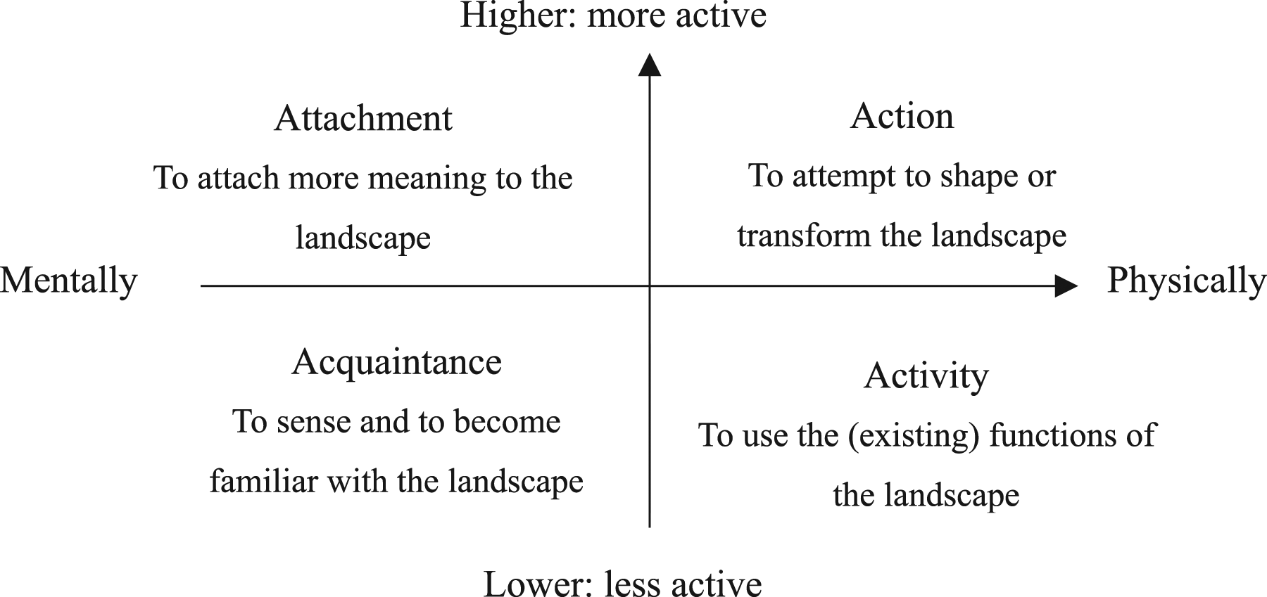
People’s responses to the landscape add significant value to it, and thus any comprehensive approach to the landscape will inevitably need to consider both the human factors underlying environmental change and human powers shaping the environment. Research methods dealing with experiential landscape perception thus focus on active interaction between humans and the landscape (Zube, 1984), including observing daily participation and personal records (Buhyoff, 1979; Cottet et al., 2018; Dunkel, 2015), surveying the public (Penning-Rowsell, 1975; Zarmati, 1980), and studying the changes in the landscape itself (Duncan, 1973).
These unifying, morphogenetic and socialised perspectives reflect both separate and overlapping spirits in landscape interpretations. The physical appearance of the landscape patterns is a result of processual changes to the urban landscape over history. The physical forms and their accompanying characteristics are historically and socially produced. They have inevitable impacts on everyday activities within the wider socioeconomic context, and vice versa. Theoretically, these three perspectives simultaneously and equally constitute landscape research, with none privileged over the others.
Landscape research and planning practice
Selected landscape planning schemes and their approach
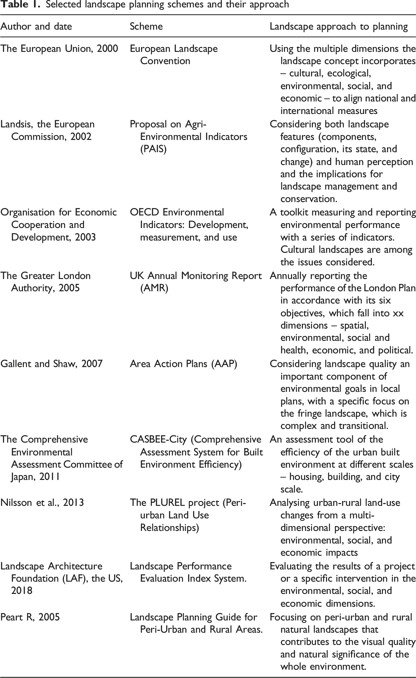
Most of the planning schemes above align with the UN Sustainable Development Goals for sustainable urban development and the protection of ecosystems, addressing the multiple dimensions of the landscape concept and embracing its key values. First, they see the built and natural environments as barely separable. Across various locations worldwide, all such schemes adopt a unified and holistic lens on the total environment, considering both man-made space and natural and ecological elements as the targets of planning intervention and conservation. Human-natural interactions are also recognised as an important contributor to the quality of the whole landscape, such as in the PAIS project and the CASBEE-City scheme. Secondly, the notions of process and evolution appear to be essential components of the schemes. They look to past generations of landscape and its history to clarify development patterns. For example, the PLUREL project specifically focuses on the social and economic particularities and historical processes of areas, considering changes across a wide scale in time and space (Nilsson et al., 2013). Thirdly, some projects such as the PLUREL project in Europe, AAP in the UK and the Landscape Planning Guide for Peri-Urban and Rural Areas under the Resource Management Act (RMA), New Zealand shed some light on peri-urban areas. These complex, fragmented, and transitional spaces are nonnegligible components in managing the landscape.
The landscape concept is being increasingly embraced by the planning discipline and helped catalyse the establishment and growing popularity of sustainable initiatives at different levels around the turn of the century. It is not surprising that the landscape concept has been applied in peri-urban planning (Peart, 2005; Wandl and Magoni, 2017). The field of peri-urban planning highlights the complexity and hybridity of the landscape (Qviström and Cadieux, 2012). Early conversations on the peri-urban landscape regarded these areas as disordered and wild and the result of urban sprawl ((MacKaye, 1962)). However, more recent literature offers alternative interpretations of these landscapes and recognises their special value (Gallent and Shaw, 2007). The value of these socially and politically constructed spaces is mostly related to their potential to mitigate urban-rural polarisation and control urban sprawl (Arts et al., 2017; Olwig, 1996; Wu, 2020).
Various landscape perspectives are intuitively considered in different schemes for different planning purposes. However, the analytical and practical value of morphogenesis is relatively neglected and this partly explains the disconnection between people, place and planning, especially in the peri-urban context. On the basis of the relationship between development processes and the resulting spatial groupings of form elements, recognition of landscape type units is significant for the understanding and planning of peri-urban areas. A more balanced conceptual framework is required to cohesively bind and integrate the epistemological orientations of landscape. If actually practiced, such mainstreaming of landscape morphogenesis is a step change from the piecemeal and generally superficial peri-urban development policies that have existed to date.
A more integrated and balanced landscape framework for sustainable peri-urban development
Landscape-based peri-urban planning tackles the interrelations between socially and culturally constructed spaces and sees the environment from the perspective of engendering and processual changes (Buizer et al., 2016; Görg, 2007; Kusters et al., 2020). It draws attention to the connection between the expressions of the environment and the practices of societies and institutions, and endeavours to align socio-economic factors with favourable future scenarios at the landscape level (Kusters et al., 2020; Stiles, 1994). Figure 3 presents the integrated landscape framework developed from this review of the capabilities and potential of the landscape concept as applied to peri-urban planning. The framework is built upon a conception of landscape in which natural and cultural environments are considered from three interrelated perspectives: their unifying, morphogenetic, and socialised values. These are not exclusive, but rather three interrelated perspectives for understanding a certain place. The landscape-based framework for sustainable peri-urban planning.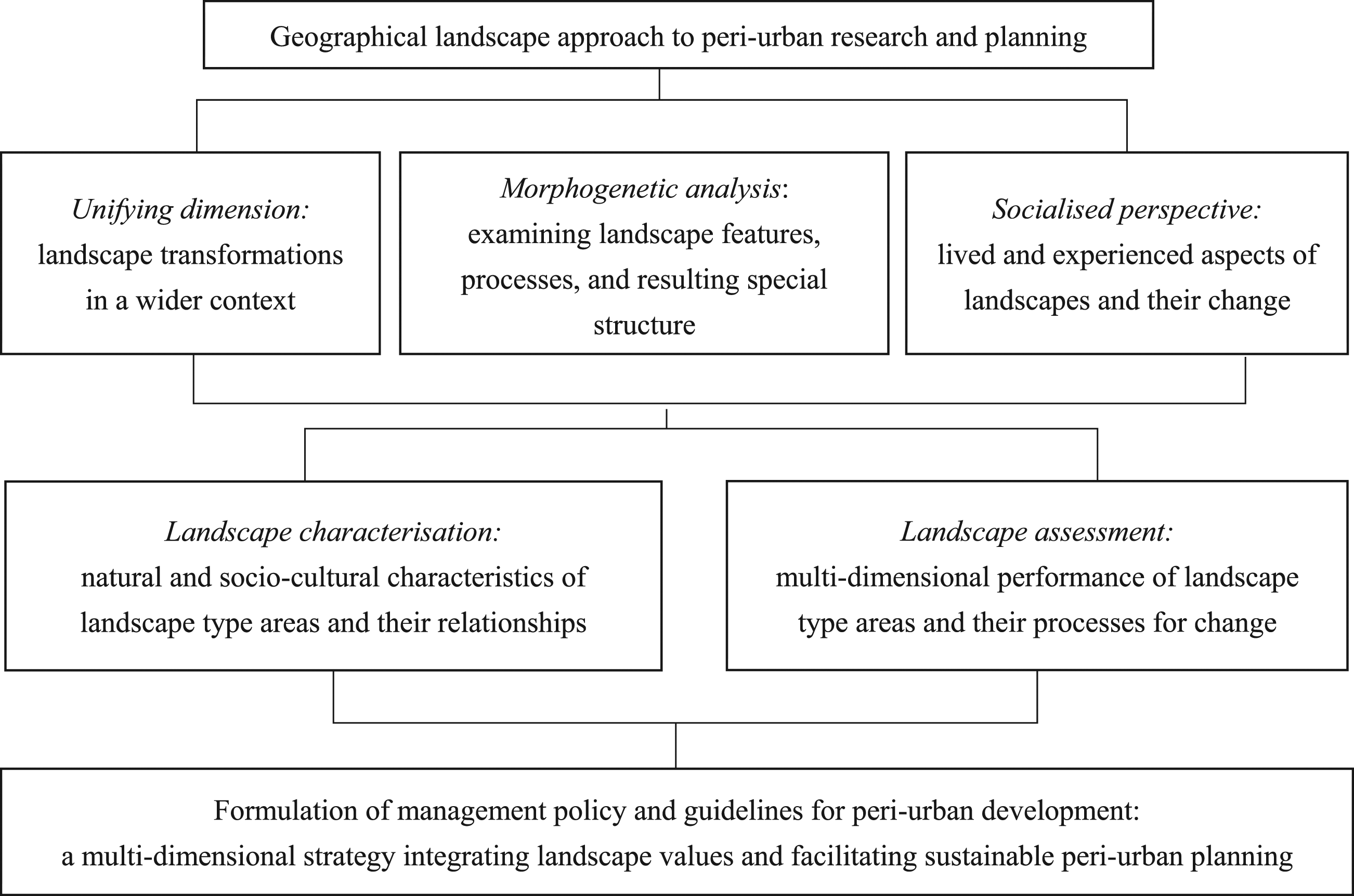
The framework starts with the chronological order in which landscape transformations occur. The development contexts include ecological environment and socio-economic background, decision-making and governmental structure. The consequence of the current state is simultaneously the context of the next phase. What matters most is the pattern of this transformation; to be specific, how the context, morphogenetic agents (Larkham and Conzen, 2014) and development outcomes work together. Moreover, their interactions with each other will form the actual structure of landscape transformation. Maintaining and enhancing this structure during the transition will achieve a structure-preserving transformation of the landscape, to reach the destination of sustainability (Alexander, 2004).
The long legacies from history and culture are distilled into powerful and distinct landscape characteristics, which are a combination of all the detailed information that contributes to shaping the place. The morphogenesis analysis encompasses the richness and continuity of community and the coherence of its forms. It reveals the value of the place that is worthy of appreciation and exploration (Jivén and Larkham, 2003; Whitehand and Larkham, 1992). The exploration of the physical landscape and its characteristics helps in understanding and interpreting the value and distinctiveness of a place (Kropf, 2011), which is an essential task in responding to the changing face of the peri-urban environment.
The experiences and participation of residents add rich socialised value to the landscape. Physically, local people utilise the landscape for their own purposes, whether or not these purposes match the landscape's intended function. Mentally, users’ understandings and perceptions attach more lively and vivid meanings and values to the surroundings. Exploring how landscape is experienced and what characteristics make the deepest impressions on users, possibly by means of interviews and questionnaires, is a powerful move towards continuous and healthy landscape development. Addressing the socialised perspective of landscapes in local plans helps ease the tension between pro-growth planning rationales and areal identity conservation, as well as deal with the threat of homogeneity faced by contemporary cities.
Rapid globalisation and urbanisation inevitably endanger the environment and the characteristics of cities, which lose traces of past societies and their stories. This makes the characterisation of the peri-urban landscape fundamental to understanding the space we live in, and to promoting sustainable and continuous spatial development. Landscape characterisation describes the landscape in accordance with the various disciplinary angles it entails – natural, socio-cultural and political, and how these angles are related and structured to finally create an integrated or unitary whole (Hall, 2008). Landscape assessment gives further information on landscape type areas and contributes to the foundation of a coding approach that deals with the heterogeneity and transitions of the peri-urban landscape.
This integrated planning approach from a landscape perspective can potentially facilitate a well-rounded understanding of peri-urban transformation and consequently formulate a feasible solution towards its sustainability. Its conceptualisation is mainly embodied in three perspectives. First, it addresses the nature of the peri-urban. The specific focus on natural, spatial, socio-cultural, and political aspects contributes to an integrated understanding and detailed characterisation of the peri-urban space. Secondly, using this landscape approach in peri-urban planning enables a sensitive response to its complicated structural nature and generative processes. Thirdly, this approach incorporates the socialised value added by the user groups, taking into consideration residents’ appreciation of their physical surroundings. This is what makes a certain landscape a “recognisable entity” (Kropf, 2011: 177). Having these aspects identified and articulated in the resulting plans will make a crucial contribution to conserving the continuity and integrity of the peri-urban space (Wang and Gu, 2020).
The framework includes an integrated view of the emergence and development of the place and generalisation of what makes the place remembered. Its central purpose is to improve the peri-urban environment without abandoning its areal characteristics and inherent values. Different to the prevailing utility-based zoning approach, the landscape coding system, in which areas, boundaries, forms, and utilities are decided according to their inherent landscape values, is more engaged with the innermost nature of the city and works effectively and responsively to conserve the urban landscape and improve its quality (Gu, 2014, 2019; Kropf, 2011). The appeal of this approach is that it provides a basis for identifying and specifying the characteristics of local space. It fits diverse kinds of locations because it departs from understanding the planning subject itself. A landscape-based and place-specific understanding of the peri-urban may further contribute to a governance framework armed with insights into both the physical elements, generative process, and wider meanings of the perceived built and natural environment.
Conclusion
The geographical landscape concept can be used as a subject of research as well as an approach to the subject. As a subject, it is where the built and natural environment are bounded and where their interactions are prominent. Studying the various components of peri-urban landscapes and how they are arranged and connected at the city, regional, or national levels reveals their characteristics and distinctiveness. As an approach, multiple conceptualisations formulate landscape research that is concerned with unifying, morphogenetic, and socialised values. In this way, the landscape concept functions as a multi-dimensional “boundary concept” that embraces the thinking of various disciplines and facilitates interdisciplinary communication (Arts et al., 2017; Opdam et al., 2015).
Peri-urban planning, as a specific focus of the urban planning regime, has the task of dealing with the complexity and the transitory nature of this type of space. The current issues and predicaments accompanying peri-urban development and planning stem from the epistemology of the peri-urban, requiring an integrated framework to tackle its problems and future. A possible solution towards sustainable planning and management of peri-urban development lies in the integrated nature of the landscape concept, which comprehensively encompasses the changing space and active involvement of generations of human societies.
This paper seeks to enhance the use of the landscape approach to peri-urban planning by foregrounding the morphogenetic nature of landscape. As a highly interdisciplinary subject, landscape offers strong capabilities for mitigating the current overemphasis on land-use planning and utilities by addressing the complicated hybrids formed by humans, societies, and nature. The current use of landscape in peri-urban planning is mostly based in landscape as an integrated boundary concept that allows for an interdisciplinary inquiry to extend peri-urban knowledge and make informed and appropriate plans. However, the three epistemological orientations of landscape can be rebalanced and reintegrated to form the basis of a new planning framework for more continuous, harmonious and sustainable peri-urban development.
The proposed landscape-based framework incorporates the landscape concept into peri-urban planning rationalities to address the complexities and transitions of this emerging urban space. This framework is a people-centred, morphogenetic-based, and integrated approach linked to space, time, and human societies. The framework is built on the three dimensions of the landscape concept – its unifying, morphogenetic, and socialised values. First, it takes advantage of landscape’s unifying capabilities to consider the natural, spatial, social, and political components and relationships that make the peri-urban landscape a distinct and cohesive phenomenon. Secondly, the morphogenetic analysis further consolidates a deep understanding of the landscape by establishing its structural relationships and contextual and processual transformations. Third, it delves into the socialised values of peri-urban landscapes and reflects on how they are perceived and promoted by users. This is a spatio-temporal analysis overlaid by the socio-cultural background and historical events. Together these three pillars form a landscape-based and place-specific understanding to steer peri-urban planning towards continuous and integrated development.
Sustainable peri-urban development is subject to how peri-urban space is understood and treated. A sensitively planned and sustainable peri-urban landscape will incorporate the continuous and coherent physical changes of the space, as well as reflecting its contextual and processual integrity and carrying the memories and aspirations of local communities. Morphogenetic research entails consideration of a landscape type area as a synergistic geographical system with its own dynamics. This approach can therefore contribute to peri-landscape management by bridging interpretation and representation to tackle complex situations. The intention is to mitigate the struggle between the natural and built environment in the pursuit of economic achievement and urban efficiency, and preserve each location's integrity based on the recognition and incorporation of its inherent nature. The scope of the landscape concept provides a solid foundation for a comprehensive understanding and specific conceptualisation of the peri-urban and supports comprehensive planning practice towards sustainable development without compromising spatial characteristics and historical traits.
Footnotes
Declaration of conflicting interests
The author(s) declared no potential conflicts of interest with respect to the research, authorship, and/or publication of this article.
Funding
The author(s) received no financial support for the research, authorship, and/or publication of this article.