
Abstract
Mined land in Cambodia possesses hazardous potential for those willing to risk its inhabitation, but this potentiality is commingled with threat and uncertainty. Mined terrain creates sites where the affordances of place clash with its dangerous materialities. Village residents in this study were engaged in ongoing efforts to physically alter the place they inhabited, but these tectonic processes were not always successful. The presence of military waste transformed the landscape into an unfamiliar ecological terrain of intermingled organic and potentially explosive inorganic elements. By 2009, large swathes of village land had been cleared of both mines and wild vegetation, giving villagers a hard-earned sense of safety. However, ongoing uncertainty remained about the state of the ground and the things buried within it. Amidst the struggle to reclaim the landscape for agriculture, mines sometimes interposed themselves, their detonations damaging bodies and lives and unsettling residents’ sense of place.
Introduction
Reaksmei Songha village in western Cambodia has been both a village and a forest. Imagine this forest, if you will, as it looked 20 years ago, when people first began to resettle the area at the end of the war. Secondary forest covers a landscape that was once cultivated then stood fallow for almost 20 years. The landscape is filled with remnants of the war: unexploded ordnance, ammunition dumps, and caches of guns. Fragments of exploded ordnance, bullet cartridges, and punji sticks litter the forest floor. Anti-personnel and anti-tank mines have been placed both above and beneath the ground. In addition to war debris, other traces of the soldiers remain – hammocks, cooking implements, shoes and sarongs.
In short, this is a landscape littered with the material remains of war. It is a place in which the ground both hides and reveals things. Artifacts and ordnance work their way slowly to the surface of the earth like a thorn in a wound. In the entangled assemblages of organic and inorganic materials that comprise the landscape, things shift, move, rust, detonate, and grow. Those who attempt to inhabit and transform this landscape are immersed in material environs in a constant state of flux and change.
Despite more than two decades of clearance of military waste, Cambodia’s landscape remains heavily littered with both landmines and unexploded ordnance, although no reliable statistical estimates currently exist. 1 In 2009, I set out to conduct a study of villagers’ engagement with a war-altered landscape. My field site was Reaksmei Songha, a village located in Ratanak Mondul district in the province of Battambang.
In April 1979, Vietnamese forces entered Cambodia and ousted the Khmer Rouge regime. The Khmer Rouge retained a fighting force of 30,000 to 35,000 troops, and throughout the next decade they continued to oppose the People’s Republic of Kampuchea (PRK), the Cambodian government installed and supported by Vietnam (Slocomb, 2001). In 1989, as Cambodian peace negotiations began in Paris, the conflict intensified in northwest Cambodia. As the Vietnamese military began to withdraw, the Khmer Rouge advanced from their strongholds and engaged the newly weakened national forces of the State of Cambodia (Rowley, 2006). 2 Civil war began again in earnest, across the farms and fields of Ratanak Mondul district. 3 Landmines were used extensively by all factions.
The reconciliation between the remaining Khmer Rouge factions and the Cambodian state was a staggered process, but the 1996 surrender of Ieng Sary’s faction of the Khmer Rouge ended the fighting in Ratanak Mondul (Fleisher, 2005). Resettlement of the war-altered district began within two years. Recently demobilized soldiers, their kin, and residents of nearby resettlement sites for returnees from refugee camps comprised most of the first post-war population of settlers.
Reaksmei Songha was a place where settlers were determined to reclaim the forested battlefields for agriculture. Residents’ hopes and aspirations for the ground were dependent upon their successful corporeal engagements with the material remnants of war. The first wave of settlers, returnees and soldiers alike, knew that they were coming to claim or buy land that was possibly mined. Envisioned futures and present needs drove residents’ practices. But efforts to create the desired landscape came up against the deadly realities of living in a place where military waste littered the soil.
The term ‘landscape’ has always possessed a productive ambiguity, encompassing a dual emphasis upon the material and the conceptual (Ucko and Layton, 1999). In recent work on landscape, it is often acknowledged that we are simultaneously influenced by our physical surroundings and ascribe meaning to them, discursively creating and being experientially influenced by the landscapes in which we live (Bender, 2006; Fontein, 2012; Ingold 2006; Simonsen, 2008; Tilley, 2004). This article is not situated in a single approach to theorizing landscape, but it may be aligned with the recent emphasis upon the various ways in which landscapes are constantly becoming. Both scholars more concerned with issues of representation and those who focus upon more embodied engagements with terrain often concur that landscapes are contingent, fluctuating, and in constant process (Bærenholdt and Granås, 2008; Bender, 2001; Ingold, 2008; Massey, 2006; Tilley, 2004).
The role of the material in creating this indeterminacy has been receiving increasing attention (Edensor, 2005; Filippucci et al., 2012; Fontein, 2010; Kim, 2016). Various studies have shown how mined terrain inhibits residence, constrains movement, and affects the reconstruction of agricultural livelihoods around the globe (Kim, 2016; Maher, 2002; Schwenkel, 2013; Unruh et al., 2003). The materials they contain give war-altered landscapes, such as former battlefields, a particularly dangerous and uncertain nature (Saunders, 2001).
In the years since the fieldwork for this article was completed, a subset of anthropological scholarship on military waste has emerged, theorizing war-altered landscapes (Henig, 2012, 2019; Kim, 2016; Zani, 2018, 2019). Former battlefields contain both organic materials and inorganic war debris, creating a particularly unstable type of terrain where the remnants of war may be dangerously active, partially degraded or inert (Filipucci, 2004; Henig, 2012). Kim (2016) has coined the term ‘rogue infrastructure’ to characterize the ways minefields both persist within and alter the ecosystems in which they are embedded. She invites a focus on how mines and humans cohabit post-war landscapes and the ‘unanticipated effects and relations’ these mines create (p. 163). In a similar vein of analysis, Henig (2019) has proposed that military waste can render engagements with the landscape indeterminate in a way that both threatens human life and allows for precarious new forms of engagement and value creation, specifically income generation.
War-altered landscapes complicate theorizations of the agency of the landscape’s human and nonhuman inhabitants. 4 In her work on post-conflict Laos, Zani (2019: 12) has posited that the explosive remnants of war possess a particular kind of agency, one of ‘mortalism’ and ‘deathliness’, that challenges the agency of human actors. She calls for attention to the social implications of inhabiting a place with latent military waste that may still explode if disturbed.
As these scholars’ studies show, military waste renders landscapes into categorically and materially uncertain places on a variety of levels. A primary aim of my own research was to ascertain what affordances or constraints material things offered to place-making efforts in the aftermath of war. This article focuses upon the role of landmines as a source of indeterminacy in the ongoing process of landscape formation in Reaksmei Songha village.
This study begins with a description of the rapid transformation of the former battlefields during the resettlement period. I then turn to a discussion of the formal status of the land as regards landmine contamination. Ethnographic examples are then used to illustrate local inhabitants’ differing levels of somatic skills and familiarity with mined terrain in 2009, the year I conducted research in the village. Lastly, I analyze two landmine accidents, contending that such jarring events renewed a sense of uncertainty about the state of the ground.
Changing ground
The village of Reaksmei Songha possessed hazardous potential for those willing to risk its inhabitation, but this potentiality was commingled with threat and uncertainty. One elderly woman characterized the first years of settlement as full of chaos or without order (ronye ronyai) and described the high casualty rates: 5
Living here before we didn’t know which day someone would die, which day lose a leg – which day to lose a leg, which day to die.
Villagers spoke of hearing explosions and running towards them, carrying hammocks and bags to carry back the bodies or body parts of the wounded. Each explosion could signify the loss of a relative or a costly draft animal.
Settlers entered mined areas to forage and to farm, to reclaim the battlefields for agriculture. One new form of post-war value creation was a harvest of the military waste via the collection and sale of scrap metal and TNT from unexploded ordnance. Successfully navigating and handling the remnants of war required skill, attention and care. Failure could and did result in death or injury. As of 2007, Rattanak Mondul district continued to report one of the highest rates of civilian casualties in Cambodia from mine and UXO (unexploded ordnance)-related injuries (International Campaign to Ban Landmines [ICBL], 2007).
The post-war settlers had gradually expanded the perimeters of traversed ground – venturing in and clearing unknown ground. Through residents’ attentive movements, and sometimes through the tragedy of accidents, known and tested paths were created, the location of mined areas established, and plots of land cleared. Such processes gradually but steadily expanded the scope of used terrain in the area.
By 2009, large swathes of land had been cleared of both mines and wild vegetation. The formal demining community had a role in this clearance, but it was largely the embodied practices of village residents that had created the changed state of the ground. People had tested and altered the terrain with their bodies. During 2009, the two main actors involved in demining were the national deminers of the Cambodian Mine Action Committee (CMAC) and village deminers. 6 CMAC has been operating in Ratanak Mondul district for over two decades now (Fleisher, 2005). The clearance priorities of the formal mine action sector in Cambodia are residential land and public land (such as roads, schools, clinics, wats [places of worship]). In addition, in heavily contaminated areas, village chiefs are also able to annually present clearance requests to CMAC, which included portions of agricultural land. But, in Reaksmei Songha, most of the land needed and used for livelihood purposes was not prioritized for clearance. By 2009, the desire to demine agricultural land was the primary driver for villagers to employ villager deminers or to conduct individual clearance activities.
Suspicious ground
In 2009, the presence and location of mines and unexploded ordnance across much of the district remained indeterminate. This was acknowledged by area residents and by the official maps of the area made by CMAC. In areas that crosscut multiple battlefields, huge swathes of land were classified by CMAC as dai songsai, suspicious ground, a term designating land that might contain mines. This classification was based upon a national-level survey conducted in 2001. 7 An additional and smaller category was jomka min pət, which may be loosely translated as ‘definite minefields’.
By 2009, the state of suspicious ground was highly variable. First of all, such ground might still contain mines and unexploded ordnance. If an area did contain mines, those mines might be corroded and therefore inactive, or the mines might remain active and able to detonate. Secondly, some areas had contained military waste at some point but no longer did – the mines and ordnance had been removed by settlers or village deminers or had detonated through contact with humans, animals, or fire.
Although the term dai songsai was known and used by villagers, residents entered land classified under this term on a regular basis. The official classification of the area did not discourage entry (Figure 1). When I asked would what cause people to avoid an area, I was told that people avoided an area if landmines had been seen there or if an accident was known to have occurred there. However, I observed that people also continued to enter various areas where accidents had occurred. The emic category of land that people appeared to truly avoid was known as dai min krah – thickly mined ground. Several places under this local classification were being demined by CMAC during my year in the village.
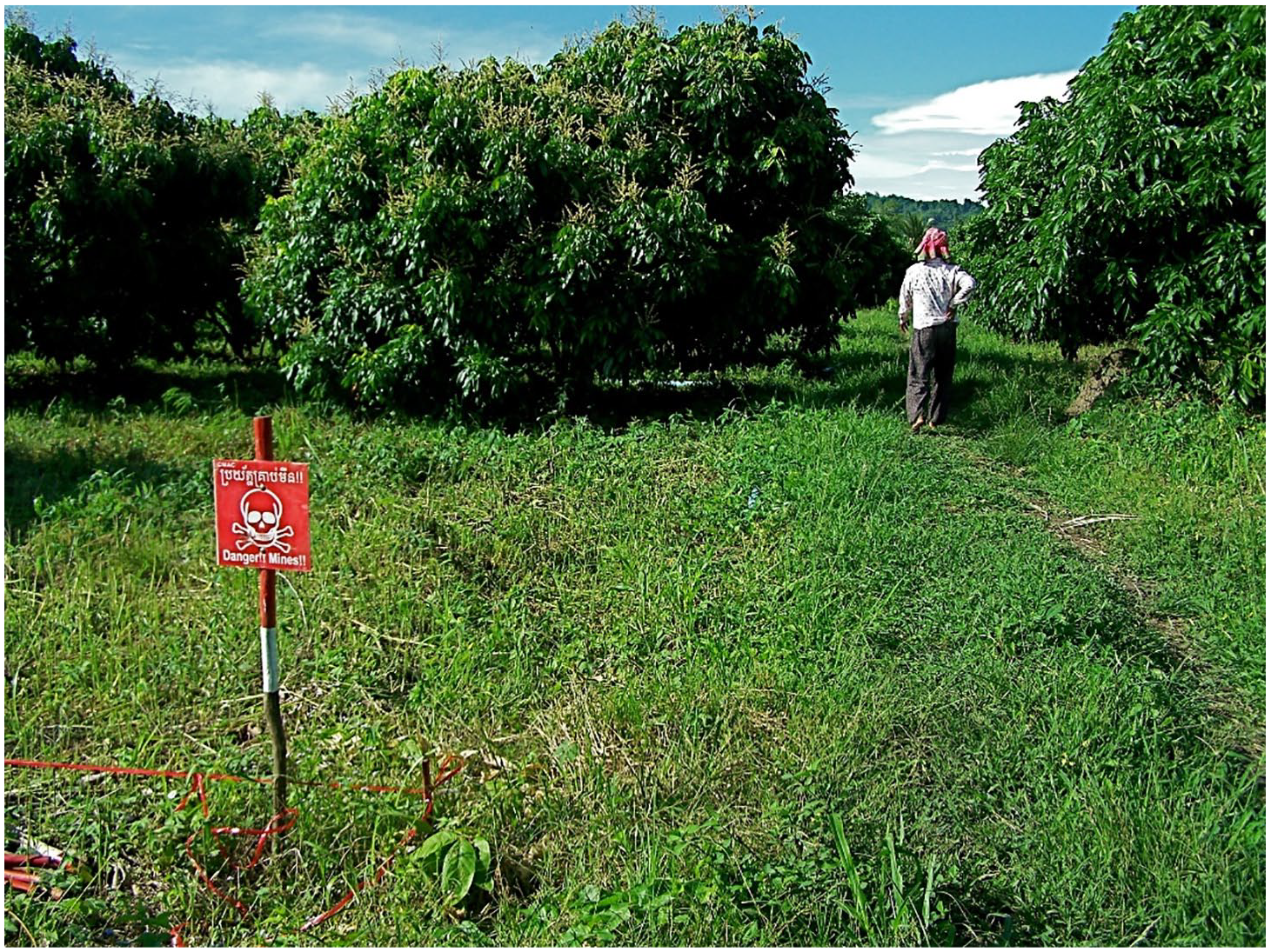
The chief’s wife walking into her longan orchard past the official demining perimeter. © Photograph: Lisa Arensen.
By 2009, many village residents knew which portions of the village had been cleared, formally or informally, and which areas remained uncleared and possibly mined. This knowledge had been accumulated through years of investigation, clearance, and prior events. Yet few ever claimed certainty about the status of a piece of ground. Places may have been well-used, but people were aware that their ultimate status remained tenuous. Sometimes mines were missed in clearance efforts and later encountered during cultivation. Sometimes they initially lay too deep to be set off but then shifted position during the rainy season. Claims about the mined status of a particular place continued to be tested and gauged by the bodies that crossed it.
When traversing ground thought to be mined, people sought out and used signs and traces of earlier movement, including animal tracks, footprints and wheel ruts. But these traces were sometimes obliterated by rain, fecund vegetation, and shifting sand. In addition, sometimes they became impassable – for example, in the rainy season, the path to my host brother Jane’s 8 farm became so waterlogged and muddy that one was forced to navigate small tracks cutting through secondary forest that had not been checked for mines. This increased the significance of familiarity with the terrain – those who had entered, used or crossed a place the most were its most reliable guides.
A great deal of once embodied engagement with mined terrain had been translated into knowledge and information that was passed from resident to resident. Accounts of prior events were often used to discuss terrain. People would explain that an area was known to be mined because a person or an animal had detonated a mine there, and it was commonly held that mines were never laid singly. They would explain to me that an area was safe because people had extensively entered the area in question already, or because cows had crossed and grazed the land. The great challenge to this way of knowing was the threat of misinformation, whether deliberate or accidental. Second-hand knowledge required gauging the reliability of the information-giver. I asked residents continually about the state of the land I walked upon, trying to avoid any land that had not been cleared by deminers. Yet I discovered on several occasions, after that fact, that I had entered uncleared ground.
Residents held several shared perceptions about mined terrain. A place where one mine had been discovered was assumed to contain others. Another common opinion was that mines were less likely to go off during the dry season.
Villagers were cognizant that mines were influenced by their physical conditions. A former soldier described to me the variances in the conditions of remaining mines: Some mines remain but won’t detonate now. They call them min koəch [rotten or spoiled mines]. Water and rain has touched them, dripped in, ruined them. They are rusted and won’t ignite or move. But of those that do detonate, many are unearthed improvised mines. They cause many accidents. You think, O, it didn’t detonate, and sometimes do not continue with your whole heart, you take them and put them in the roots of trees; some people take them to hammer and saw open, to rig them, accidents [happen] like that.
Many villagers took a less cautious view of the remaining anti-personnel mines. A commonly expressed idea was that the remaining mines were spoilt. The string-triggered mines were regarded as utterly corroded, their strings rotted. The metal pressure mines were said to be all rusted. Various people acknowledged that the plastic mines, known locally as wind-mines, were resistant to the elements, but others did not distinguish the plastic mines from other anti-personnel mines. The following woman’s comment was typical in nature: ‘We aren’t worried about little mines, they are spoiled after a long time.’ Technical demining experts confirmed that metal mines were indeed vulnerable to water and that string-triggered mines were largely inactive after years of exposure. However, metal mines planted beneath the ground were not necessarily inactive, and plastic mines were commonly unearthed in district villages.
In 2009, the sound of ordnance and mines detonating in the distance had changed in terms of what it signified. At first these explosions frightened me – they can be incredibly loud, and within a certain radius bystanders feel the compression of the air. 9 In the following excerpt from my fieldnotes, I was sitting under an elder’s house in a neighboring village. An enormous explosion rent the air, followed by the laughter and shouts of children.
I turn to the elder, startled witless – ‘it’s CMAC destroying ordnance’, he assures me. He adds: ‘The children watch from the road, they don’t let them come close. Normally they announce detonations first.’ ‘How often do they do that?’, I ask. ‘Once a month or once a week’, he says, ‘but normally they announce it 5 or 10 minutes before.’ ‘Do you ever think it’s an accident now?’, I query. ‘If the sound came from there’, he says, indicating the forested spring east of his house, farther along the road into the village, ‘we would be worried – which person or which cow [has set off the ordnance]?’ He gestured to the north side of the village and adds, ‘But over there is CMAC.’ The deminers have two sites they are currently demining in this village.
The elder’s lack of alarm amplified how rapidly circumstances were changing for area residents. As the mined terrain became increasingly clear and fewer villagers were engaged in clearance activities, these noises no longer necessarily meant death or injury. Across the country, a trend in falling casualty rates began in 2006. 10
On uncleared land
Across Reaksmei Songha village, the amount of mined terrain was decreasing. Nonetheless, mines remained in 2009, and a variety of people continued to risk engaging with them in their agricultural livelihoods. Planting crops on uncleared minefields was generally acknowledged as the riskiest enterprise for area residents, and this activity, once engaged in by all settlers, was now limited to certain places. The western edge of the village in the foothills had been more recently settled than the center of the village, and most of its residents were still engaged in clearing the forest and the remnants of war by hand. Their area, one soldier-farmer said firmly to me, was not a place where one could walk around carelessly. Most residents still plowed with draft animals or motor-drawn plows, or hoed by hand, and these villagers sometimes unearthed landmines in the fields or struck anti-tank mines with their hoes. The motor-drawn plows regularly turned up mines that farmers had missed in their initial search.
Thuan’s family was one such family – they had come to the village as tenant farmers in 2004, and in 2008 they purchased a few hectares of partially uncleared land where mines remained. He was clear-cutting and demining the back hectares of his farm himself – he said he could clear about 10 meters a day in the dry season. Once the initial cutting, burning, and manual search for mines were finished, he planted crops on the charred soil. He had found 16 mines to date, both pressure-triggered mines (called ‘step-upon mines’ by the villagers) and string-triggered mines. Some were still live and some had been detonated by fire.
Village farmers with means hired others to clear-cut and demine their land. In most cases village deminers would not survey land that had not been clear-cut first. They would search land cleared of forest for remaining anti-personnel mines and anti-tank mines. Once this clearance was completed, farmers hired plowmen with tractors to plow the land, or, in a few cases, purchased their own tractors. Hired plowmen would usually not plow land that had not been demined because of the risk posed by anti-tank mines.
Economic status created a hierarchy of risk-taking – those with means hired poorer others to do the risky work for them. Clearing land for farming in the area necessitated that someone undergo the risks involved in doing so. The wealthy plantation owners in the area hired laborers, made arrangements with tenants or enlisted landless kin.
The deminer’s landscape
The village resident most familiar with mined terrain in 2009 was almost certainly the village deminer Vanak. An anti-tank mine weighs five kilograms, Vanak told me. Lifting it was not a problem. Stepping on it was not a problem. When he found his next anti-tank mine and removed it, I could come and see it. He agreed to take me out one morning to see the land he was currently demining for one of Jane’s patrons. Anti-tank mines are only a critical issue for those successful enough to be able to use tractors on their land, Jane explained. Some mines have had tree roots grow over them, go undetected by deminers, and are walked over uneventfully by people, but when compressed by the weight of a tractor, they detonate. I spent the day before this visit growing increasingly afraid. I was particularly preoccupied with my feet and found myself staring at them at regular intervals.
Vanak turned up mid-morning and we rode off on a single motorbike. We traveled along a series of increasingly small paths. Vanak had demined a 15-meter-wide band for an organization who then built up the paths we were using. There were soon no houses around us and the terrain was pocked with secondary forest. Vanak abruptly turned off the road entirely. There was a road ahead, he explained, but it was an old road from before the war, and he did not trust it. He had cleared these fields himself. The fields were infinitely more difficult to travel across than the rough paths had been. We jounced across the ruts left by tractors, scraping through brush and the spiky stubble of dry season grass. After a long diagonal ride, we crossed another large stream and then suddenly stopped. A few cooking pots and a backpack were piled under a tree. I stood without moving. There were dried leaves underfoot, so many leaves that I could not see the earth below them. Dried grass tussocks and brush were strewn across the landscape, interspersed with taller shrubby trees. We demined here already, Vanak said over his shoulder, strolling off. I followed directly behind him. The landscape was mutable, covered in grass and leaves. How could anyone tell where people had walked, or sat, or cleared the ground? Without Vanak sauntering ahead of me, I would not have dared to move about at all. They had found no mines today, he said, only metal fragments. He stopped well back from his companions. A plastic string was stretched through the brush, tied on small trees at its ends. It was a perimeter, marking the extent of their clearance. When they had inspected an area, they moved the line to a new area and continued demining. Three figures weaved slowly through the trees, passing metal detectors over the ground. One was his son and another his nephew. He only trusted the careful to work with him, he said. If you lose a limb, he stated, what work will you do?
The area had not been clear-cut, and I noted this to Vanak. The owners had not dared to cut it, he said. ‘Can you demine forested areas?’, I asked as we walked along the edge of the secondary forest. He could, he said, if there was no grass under the trees. He did most of his mine clearance in the height of the dry season, January to April, when the grass was sparse and dry. When his crew unearthed an anti-tank mine, they summoned CMAC deminers. This land was part of the moving battlefront between state forces and Khmer Rouge troops during the 1980s and 1990s, Vanak said. After the war, the land had been redistributed into plots, but few had dared to use it. The streams were mined. Now the poor had sold to the rich, and the rich hired him to demine the land. His crew was finding mainly anti-tank mines in this area. He led me across the ground and showed me a hole where an anti-tank mine had been unearthed. It was a small undistinguished hole, about a foot in diameter, and its edges were already caving in, obscuring its depth. A CMAC landmine warning sign had been posted to a stake near the hole. ‘Does that mean people don’t enter here?’, I queried. ‘Many don’t dare’, he said.
He drove me home. I saw movement in the distance as we rattled back across the fields. A woman and a child were entering the thicker forest that flanked the spring, carrying a machete. They had come from a tiny thatch hut built beneath a tree, so small I had failed to make it out on our drive in. ‘What are they doing out here?’, I demanded. ‘They are poor’, he said. ‘The poor live far from the roads.’ I fell silent, watching the two figures vanish into the forested area around the stream.
I went back with Jane months later. Jane’s crew was sowing rice by hand. One of the crew, Bho, drove a tractor behind the sowers and plowed the seed under, before the waiting myna birds could snatch it (Figure 2). The secondary forest that had covered the field was gone, along with the undergrowth. We watched the tractor lurch as it rumbled over the ground, leaving clouds of dirt in its wake. One edge of the field was choked with long grass and tangled vines sprawling down to the stream. The vegetation there was too thick to demine and had been left uncleared.
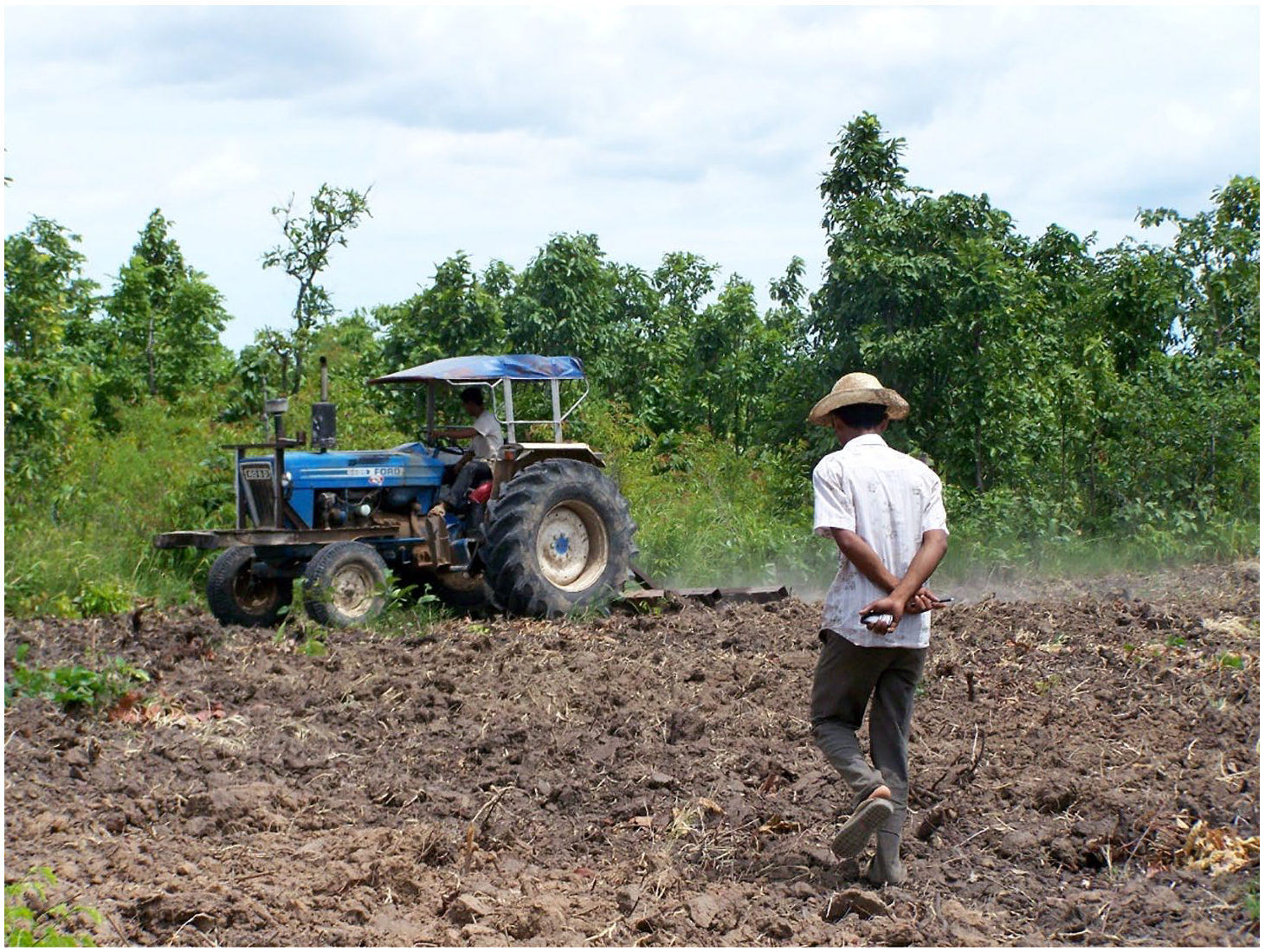
Jane overseeing sowing on the newly demined land. © Photograph: Lisa Arensen.
‘So did Vanak find any mines here?’, I asked Jane. He didn’t know, Jane replied. He added, ‘I was too lazy to ask.’ Did he not care if there were any mines? I asked incredulously. I would have wanted to know how many and what kind, I told him. Jane laughed at me and said: ‘I just want to know if they are gone or not.’ For Jane, the remnants of war were merely an obstacle, a hazard to the stuff of agriculture, to his ability to convert the land from forest to farm. He was not curious about these remnants of war. He simply wanted to be rid of them.
Jarring materialities: Landmine accidents
Many of the antitank mines buried along roads and paths had detonated or been removed by 2009. However, antitank mines remained on agricultural land. Informal mine clearance by villagers generally occurred on, or a few centimeters under, the surface of the earth. Antitank mines were generally more deeply buried, sometimes up to two meters below the surface of the earth, and were often missed in manual clearance without mine detection equipment. Manual farming methods could go on over such mines without incident. But the possible presence of antitank mines, deep below the surface of the earth, resulted in ongoing indeterminacy about the state of agricultural ground in Reaksmei Songha village, an indeterminacy that most affected those with the means to plow their fields with tractors and the men hired to drive those tractors.
Jane was one of these men. Jane had two tractors and a crew of four men who worked with him, including Bho, a widower with two children. The tractors were used on the family farms, Jane’s patrons’ farms, and on anyone else’s farm with the means to hire them. Occasionally a competitor would drive into town along the red road. They were often headed further north to more remote villages. All of those villages still had mined ground. Be careful of those that say their land was already demined, I heard Jane warning one of these outsiders one day. Ask which deminer did the work and then ask him personally, he urged. Underscoring his point, a plowman was killed in 2009 in a northern village, plowing others’ land.
The matter of safety did not simply apply to whether a landowner was lying about the state of their land but also to the quality of clearance procedures. Some villagers placed more trust in hired village deminers than the national demining body. Hired deminers lived in the village. Their livelihoods were at stake if they missed something. Most of the CMAC deminers were outsiders and therefore considered less accountable. The largest act of state clearance completed during my residence in the village was the clearance of a large tract of land encompassing three villages, including Reaksmei Songha village. The low-lying land had been a notorious ‘thickly mined’ area, left untouched by most of its owners. CMAC demined the area, distributed sacks of rice seed to the delighted farmers, and arranged to have it plowed. This was an altruistic act but also one designed to gain the trust of area residents. Plowing demonstrated the effectiveness of the clearance.
Jane and his crew were hired by CMAC to plow the land on the government’s behalf. They were given a map of the cleared area, which had also been demarcated by concrete markers along its perimeters. Not all the mines in the area could have been removed, Jane told me skeptically; there had been a great many mines. I went away to the city and returned to news of a near disaster. Bho had detonated a mine in the ostensibly cleared zone while plowing. He turned at the edge of the field he was plowing, and there the mine detonated, under the back tire. Luckily, it was a small anti-personnel mine, and the wheel was not destroyed and no shrapnel struck any of them. Bho was unhurt but terrified. The question, of course, was whether the map of the cleared area corresponded to the actual area of ground cleared and a mine had been missed, or if the area had been inflated for the official record. Jane had been furious. Jane’s temper was an impressive thing, and I asked what he did next with some trepidation. He had gone to the CMAC camp, he said shortly, and made the deminers come out to the area and walk the perimeters of where they had cleared.
Jane had refused to let his workers continue plowing until the state deminers proved their claims with their bodies. The state of the ground did not necessarily correspond to the tidily drawn sketches of cleared land, in cartographic representations of place. It could only be confirmed through corporeal engagement with the material terrain on the edges and margins of cleared fields, via the bodily movements of men and women.
Near-disasters, like Bho’s, jarred area residents’ hard-earned sense of security. The residents of the mined landscape had painstakingly developed a collective body of skills and knowledge about inhabiting mined terrain. When accidents occurred, such knowledge was brought into question. A place thought safe or objects thought inert were shown to still harbor threat, or a person thought capable of engaging in hazardous activities was shown to be vulnerable to injury and death. A state deminer was injured in a neighboring village in 2009. At the time of the accident, his team was manually demining a patch of brush on the edge of a maize field, on the east side of a spring where a man and two cows had lost limbs in preceding years. I was permitted to accompany the CMAC accident inspector for the district on his investigation. The demining site had been abandoned when we arrived. The farmers who owned the land met us at their small thatched house and walked us back to the site of the accident. The site of the explosion was only a few feet from the planted stalks of maize, on a patch of ground cleared by brush-cutting shears. The only visible physical evidence was a small hole in the ground – we saw no blood or shrapnel, virtually nothing to indicate that a mine had exploded and taken a man’s eye and ended his career less than 12 hours before. The accident had occurred at midday. The deminer had lifted his protective visor during a rest and failed it to put it back down before he kept manually probing for mines. The lack of visual evidence was unnerving to me, as was the terrifying proximity of the accident to where the farming family had hoed and planted their maize.
The accident inspector, inured by years of investigating calamity, said without visible emotion that he had gone to the hospital and tried to ask the injured man about the accident but that he was screaming too much. The accident was due to human error but, as the head of the demining unit said to me, men are not machines, and demining procedures were not always followed with exactitude. Such deviations were often prompted by the weather. The deminers operated in a habitus of exacting methodical precision, but they were still immersed in the same climate that surrounded the rest of us, and their protective equipment was stiflingly hot in the humid air of Cambodia. The accident terrified the victim’s fellow deminers so much that they abandoned the site entirely, promptly reclassifying the terrain as dense brush unsuitable for manual clearance.
Conclusion
The aftermath and aftershocks of war are clearly embodied in landmines and unexploded ordnance (Stoler, 2008). Mined terrain in Reaksmei Songha created sites where the affordances of place clashed with its dangerous materialities. Those who lived, traversed or worked on mined land in 2009 continued to test their knowledges and skills with their bodies. Although casualties had greatly decreased, there was always the potential of embodied practices failing and an accident occurring. The Khmer term miən kruah tnak encompasses both potential threat and actual event. It can mean ‘to pose danger’ or ‘an accident happened there’. When threats became realities and landmine accidents occurred, in addition to physical injury or death, the acquired local habitus of the mined landscape was jarred and knocked askew.
This study takes as a starting point the position that the places we live in influence us, and that the landscapes we make act upon us in return. Area residents were engaged in ongoing efforts to physically shape, interpret, and ascribe significance to the place they inhabited, but these tectonic and meaning-making processes were not always smooth or successful.
For people experientially engaged in a world rife with uncertainty and danger, interpreting the landscape and its unruly contents was one means of ordering and rendering legible their surroundings. Yet such processes of interpretation could not remain in the realm of the conceptual – they were formed and tested with human bodies and lives, in corporeal encounters with the materialities of soil and mines. In a mined landscape, failure and disjuncture in classification could be not only unsettling but deadly.
The former battlefields of Reaksmei Songha demonstrate that one of the reasons place-making is a continuous process is because people interact with material environs that are themselves in a constant state of change and becoming. Village residents and government deminers were attempting to recreate the pre-war world of agricultural bounty but the presence of military waste rendered the landscape into a new ecosystem, an entangled zone of organic elements and potentially hazardous inorganic ones (see Kim, 2016).
The forested former battlefields were replete with war remnants in a state of constant flux. These material entities behaved according to the properties of their physical components: shifting, growing, decaying, tarnishing, rusting, and detonating, to name but a few options. As Ingold (2007) has argued, such transferring substances and fluctuating materials reveal the inadequacy of a theoretical focus upon seemingly contained objects and subjects/bodies. The nature of their material properties meant that different objects had very different temporalities. For example, metal landmines in the area had begun to rust and deteriorate, yet some of the plastic mines remained in their original state. The flow of materials both undid and created hazards and resources (see Fontein, 2010). Moreover, the temporal flux of materials meant that objects of military waste were not always easy to interpret in terms of their explosive potential, providing yet another aspect of uncertainty to resettlement efforts. As Zani (2019) has argued, the remnants of war possessed a latent and mechanistic but deathly power that human agency did not always overcome.
As a result, even more than a decade after the end of the war and determined human efforts at transformation, ongoing uncertainty remained about the state of the ground and the things buried within it. Amidst the struggle to transform the landscape, mines sometimes interposed themselves, their detonations damaging bodies and lives and unsettling residents’ sense of place.
Footnotes
Acknowledgements
I would like to thank my peer reviewers for their insightful critiques and suggestions.
Author’s note
Lisa Arensen is currently affiliated with the Institute of Asian Studies, Universiti of Brunei Darussalam, Bandar Seri Begawan, Brunei Darussalam.
Funding
The author disclosed receipt of the following financial support for the research, and/or publication of this article: This ethnographic research was made possible by funding from several sources. I gratefully acknowledge my receipt of an Overseas Research Scholarship and a Research Award from the University of Edinburgh. My fieldwork was generously supported by the Luce Foundation through the Centre for Khmer Studies, and an initial scouting trip was made possible by the Tweedie Exploration Fund.