
Abstract
This article uses a novel quantitative methodology to examine sepulchral material culture. Drawing on the theoretical frameworks of social spatialization and art as agency, the authors contend that variations in grave designs and materiality cannot simply be explained in terms of changes in fashion and mentality. Other factors also need to be taken into account. Using a digital data collection tool, the Cemetery Surveyor Application (CSA) developed at the University of Luxembourg, they compile a set of data encompassing all the material aspects of each grave in a cemetery in Luxembourg (Western Europe), the setting of their case study. The graves are dated from the 1850s to 2015. |The authors compare the chronological evolution of the most recurrent material features with a GIS-based spatial analysis of the same features. The results of the spatial analysis not only largely confirm the chronological study, but also allow them to be more precise (dating is often problematic) and include undated graves (a third of the sample). The digital data collection tool also allows them to compare cemeteries and to highlight variations in these that cannot merely be imputed to chronology, but also to spatial proximity and material agency.
Just as we cannot think of spatial objects at all apart from space, or temporal objects apart from time, so we cannot think of any object apart from the possibility of its connexion with other things. (Ludwig Wittgenstein, 1922: 2.0121)
Graves were, arguably, among the first man-made points of reference in nature marking a culture’s past presence and its future past. The Greek word for grave (μνήμα) is derived from the root σῆμα (séma for sign or signal). Robert P Harrison (2003: 19) notes that ‘a place is where time, in its human modes, takes place. A place cannot come into being without human time’s intervention in nature’s eternally self-renewing cycles.’ Burial sites signify the bygone lifetime of fellow humans and represent a material connection between the deceased and the living. Burial practices and locations have undergone major transformations and still vary considerably, even within Europe (Kolnberger, 2018; Laqueur, 2015).
Cemetery research is a multidisciplinary and often transdisciplinary field that archaeologists, historians, art historians, geographers and sociologists investigate, although they mostly only address materiality implicitly. When the issue of materiality is tackled directly, a series of questions and challenges emerge, which we explore in this article. Following a brief review of current trends in cemetery research, we discuss how not only the theoretical framework of social spatialization, but also the material agency enrich the analysis of sepulchral cultures. Drawing on these two approaches, we intend developing a novel method to highlight and explain the material agency of graves. The empirical part of this article presents the quantitative spatio-material methodology and its digital toolset as well as describing our case study’s setting in Luxembourg (western Europe).
This study shows how spatial analysis of individual graves complements purely chronological studies of grave designs. Our method allows us to take other factors besides the ‘Zeitgeist’ into account, such as the spatial proximity and the active emulation of neighbouring graves’ shape, material constitution and accessories. The presented results aim to open up new research avenues to explore the agents involved in and the impact of materiality.
Cemetery research
In Europe, archaeological excavations of modern cemeteries are very rare (e.g. Anthony, 2016; Kenzler, 2002); consequently, investigations into the sepulchral infrastructure, material décor and furnishing mostly comprise an assemblage of surface elements explained in relation to legislation, local and church authorities (Bertrand and Carol, 2016; Rugg, 2013), questions of social identity (Cipolla, 2008; Mallios and Caterino, 2007; Mytum, 2006; Reimers, 1999), ideology (Bernbeck and McGuire, 2011; Chadha, 2006; Gorman and DiBlasi, 1981) and emotion (Tarlow, 2000, 2012). Gravestones and accessories have been examined, for instance, in terms of consumer choice in order to determine how the class, or the ethnicity, of grave owners affected their choice set (Clark, 1987). Buckham (2000) has also touched on grave owners and designers’ ambivalent identity and behaviour as consumers with their own needs and desires, confronted with a certain commercial offer and legal framework. In this respect, her focus is on the human agents and not the materiality itself as such.
Art historians interested in the evolutions of style and archaeologists questioning its functionality have mainly addressed the question of materiality, although rarely in terms of agency. The study of graves and gravestones’ material features often produces models of seriation relating observed changes to societal transformations (Deetz, 1996; Mallios and Caterino, 2011; Streb, 2017). The historical evolution of modern cemeteries and the rationality – in contrast to churchyards – of this clearly defined and designated place has attracted much attention (Rugg, 2000; Sörries, 2009; Zentralinstitut für Sepulkralkultur Kassel and Sörries, 2002). Surprisingly, even geographical research into ‘deathscapes’ has largely ignored the ‘production of space’ (Lefebvre, 1974) on the micro-level of the grave, being more preoccupied with questions of planning, design and the management of a burial space as a (semi-)public space (Anderson et al., 2010; Maddrell and Sidaway, 2010). In general, the focus is on a cemetery in its entirety, not on individual graves, except in the case of mausoleums, or remarkable tombs built for princes and other famous and/or wealthy individuals. The current trend for highly individualized graves that are conspicuous in an ‘ordinary’ cemetery has attracted the attention of sociologists (Benkel, 2013). However, the materiality of conformism and its subtle shifts in shape, or modest utterances of dissent, remain largely unexplored.
We propose to use GIS (Geographic Information System) technology to look at this microgeography in order to identify commonalities and deviations in terms of the material, shape and décor. Within a cemetery, there are always different sections. Certain subdivisions are evident (e.g. old and modern parts, delimited by walls or hedges, located on different levels); others are invisible to the naked eye. Within these sections, each grave comprises countless individual decisions. We intend combining social spatialization and a reflection on ‘art as agency’ in order to gain a better understanding of a grave’s agency in terms of influencing the shape, form and design of others (Gell, 1998).
Social spatialization
The analysis of what has been labelled ‘social spatialization’ (the English translation of production de l’espace, a concept that Lefebvre propounded in 1974) is based on the premise that space is not a passive or neutral geometry, but that social actions produce and reproduce it.
This process includes three elements that may interact closely in cemeteries. Firstly, ‘spatial practices’, such as property, inspection and care, have a direct impact on the environment. Secondly, ‘representations of space’, for example, the planning and rules that local (and sometimes religious) authorities define, organize a given space. Thirdly, there are ‘spaces of representation’, or collective experiences of space, that Lefebvre regards as potential forms of resistance or transgression, but they may also reinforce social order (Urry, 2004: 11). Cemeteries, for instance, endeavour to ensure enduring bonds with the dead and to embody their and their bereaved families’ social status. In other words, a grave’s presence indicates and – at the same time – alleviates the absence of people (see Bleyen, 2010; Bille et al., 2010; Meyer, 2012). Moreover, burial sites are places of demarcation: etymologically, Friedhof – the German term for cemetery – refers to an enclosed (eingefriedet) area (Sörries, 2009). The English word cemetery and the French cimetière are derived from the Ancient Greek koimeterion or resting place (Kselman, 1992). These ‘resting places’ were increasingly set apart from the living. Cemetery research highlights the specific character of ‘the boundaries between the living and the dead, between death space and domestic space’ (Meyer, 2012: 106). However, Stavrakopoulu has pointed out that ‘the territorial potency of burial places expresses the claims of the descendants of the dead to the land in which their ancestors are materially present’ (cited by Ramanillos, 2015: 570). Spatially speaking, like a Russian nesting doll, a cemetery gives the impression of private enclosures of graduated size in a public setting (Benkel, 2013: 47ff).
In this respect, the notion of ‘heterotopia’ comes into play. Cemeteries may be regarded as ‘heterotopias’ – less in the sense of Lefebvre (who used the term, according to Harvey, as quoted by Johnson (2013), to indicate that ‘liminal social spaces of possibility were “something different” and not only possible, but fundamental for the defining of revolutionary trajectories’) – than in the sense proposed by Foucault (1984; Johnson, 2006). Indeed, cemeteries figure prominently among the examples that Foucault gives of spaces of ‘otherness’, caught between the physical and mental worlds, and fraught with their own rules of conduct and access rights. Within this line of thinking, the individual grave may likewise be seen as subjected to conflicting regimes: consumer choice, on the one hand, and duty towards the deceased, on the other. Consumer choice, based on the available choice of, for example, material and designs of gravestones within the immediate sphere of information collection, as well as any notion of duty towards the specific wished of the deceased can be investigated using ethnographic and sociological methods. These are complementary to the present study, but not our objective here.
Besides countless individual decisions, cemetery regulations account for the assemblage of materiality that constitutes the space referred to as a cemetery. These regulations are usually readily available to researchers. However, as is the case for the cemetery under scrutiny here, and as we encountered in many other places of that particular region of Western Europe, these regulations have been interpreted rather liberally over time and provide details mainly towards the size, especially the height, of a grave monument, while further design details are more or less up to the issuing party.
For our research, we are aware of the many possible variables that determine the grave owner’s choice, as we are also aware of the difficulty of clearly separating such variables from each other. It is practically impossible to determine causality in such a complex process. Our focus is therefore on the spatial effects, more precisely, on the ‘neighbourhood effect’, a term that the geographer KR Cox (1969) originally proposed. Taking its cue from Cox’s argument that the people with whom others deal on a daily basis influence their voting decisions, this article examines the choice of grave type, material and décor in terms of its spatial proximity to other graves. When people are confronted with the death of a close relative and buy a ‘funeral concession’ for burial purposes, they have some time (in Luxembourg up to three years) to decide on the gravestone and slab’s physical appearance. Within this time, they consult one or various stonemasons, who propose certain options within the same price range. Why, then, are some options more popular than others? Why are there higher concentrations of one option in certain areas of the cemetery? Although a stonemason may push a specific option, we propound that existing graves in a new site function as silent advertisements. Inspired by the surrounding graves, consumers often seek to ‘fit in’ rather than ‘stand out’. Based on the empirical findings detailed below, we hypothesize an emulation effect in cemeteries: grave owners copy elements based on existing artefacts and spatial proximity, resulting in unique cemetery patterns made visible once the spatial component is considered.
Material agency
The ‘material turn’ and the ‘spatial turn’ are correlated by the production of space being conceptualized as ‘a relational space’ that includes interactions between humans and things (Woodthorpe, 2010: 121). Similar to any built environment, a necropolis reveals an historically evolved spatiality that has become ‘reified in a series of sedimented enactments’ (Law, 2002: 96). This reification, however, has an agency of its own. In the terminology that Alfred Gell (1998) proposed, the material entity can be described as an ‘index’ which motivates effects, such as inferences, responses, or interpretations. Gell’s work is concerned with the efficacy of an art object. The question is whether this type of indexicality of an object could be applied to ‘arts and crafts’, or even to an industrially reproduced item. Gell’s reflections are directed at a tribal society and ‘magic’ objects; he describes how an index relates differently to artists, to the recipients, but also the ‘patients’, of sorcery. Without seeking to replicate, or build on, his very intricate formulas, we suggest that graves may be seen as indices representing a departed person, or even death itself. Graves enable transactions, such as expressing and dealing with grief. Grave owners may be seen as ‘recipients’ who decide on the grave’s design (within the range of options that the ‘artist’ or stonemason proposes – in a process of ‘consecration’), or, indeed, as ‘patients’ whom ‘their’ grave and those of others affect. The graves themselves ‘do’ something: they remind, they console, they open old wounds, they distract. They certainly fulfil the ‘minimum qualification for social agency’ (p. 16).
The cemetery, with its nested enclosures and cellulous structure, is an ideal setting for a case study in order to investigate ‘material things as an ever-changing bundle of relations, to emphasize the way they are constantly fluid and in flux’ (Fowler and Harris, 2015: 128; compare Geismar and Horst, 2004; Pels et al., 2002). Firstly, a typical cemetery is clearly delineated. Secondly, the surface of a present-time cemetery is dynamic (see Sørensen, 2010). Thus, there is no need for physical excavation to identify contexts, as it is possible to establish the sequences of grave object ‘sedimentation’ on the surface. Old and brand-new graves share the same ‘event horizon’, wherein the old never stops being present, unless a ‘concession’ runs out and a grave is cleared. In this case, the plot is either vacant or a new grave occupies it. In a Heideggerian way, graves are constantly ready-to-hand (zuhanden) for grave owners, who don’t think about their existence, but at the same time they are present-at-hand (vorhanden) for our scientific analysis. Thirdly, this dynamic surface is subdivided into self-similar units where flux can be charted, detected and correlated.
It is not farfetched to suggest that a cemetery, graveyard, or burial ground is the result of the abovementioned multiple interrelationships between materiality and subjects. However, despite many researchers acknowledging and appreciating such issues, their results are often limited to diachronical presentations of sampled gravestone features, such as the size, material and design, and their changes over time, which originate from James Deetz and others’ seminal works (Deetz, 1996; Mallios and Caterino, 2007, 2011; Streb, 2017; Tarlow, 1999). These authors, for example, applied battleship diagrams to illustrate and support their interpretations. Going beyond traditional cemetery research on the changes over time, we want to add the graves’ spatial relations and the interplay between objects and subjects. In an object-centred approach, things are not only ‘good to think with’, to paraphrase Lévi-Strauss’s famous quote, but also ‘good to analyse with’ (Gerritsen and Riello, 2015; Harvey, 2009).
Data collection
At first sight, cemetery space is ordered chronologically. There is usually an older section and a sequence of new extensions. In Western Europe, cemeteries are usually clearly demarcated by walls and gates. Internal subdivisions reflecting social status are often less visible (see Herman, 2010: 305, 312; Oliver, 2004: 241; Sørensen, 2010: 116). As Richard Francaviglia (1971: 506) noted for the US, ‘there are good and bad neighbourhoods in cemeteries as well as cities and towns’. This social ‘segregation’ is, however, far from being the rule. In our case study, as in most modern cemeteries we have seen that in the border region between Luxembourg, Germany and France, grave plots are assigned to customers strictly in sequential order and cannot be chosen freely. There might be a limited choice between available vacant plots. The historical distinction between so-called ‘Reihengräber’ (‘sequential grave plots’) and ‘Wahlgräber’ (‘grave plots of choice’) is no longer relevant in Luxembourg.
There are, however, two major obstacles to this chronological order, assimilating time and space. Firstly, grave sites are only ‘rented’ for 15 to 30 years. If a ‘concession’ is not renewed, the old stones are destroyed, kept as decoration in a different part of the cemetery or, more rarely, transferred to a museum. Human remains are either relocated or left in place. These secondary burials are conducted covertly and the excavated bodily remains reburied anonymously in assigned areas. The space is cleared, reassigned and reused for a new grave. The exceptions are Jewish and Muslim burial places, military cemeteries and tombs of celebrities. Continental European cemeteries that have no eternal resting place for human remains thus show far more complexity and dynamics over time than comparable Anglo-American examples.
Secondly, a grave can be used for up to nine bodies. Such ‘family graves’ change over the years. Sometimes grave owners merely add the name and dates of an additional occupant, but sometimes the entire grave design is altered. The exact dates of these changes are often impossible to trace and the grave itself has to be examined as if it were a palimpsest showing traces of many interventions. While we collect all possible data on the surface of graves and grave markers, we emphasize that we exclude any data that could be gathered from below the surface.
For our research we assume that the changes in style are not only due to changing fashions and mentalities (see Deetz, 1996), but also to the grave owners’ active choices as influenced by the materiality surrounding ‘their’ site; that is, the microgeography’s spatial influences due to the grave’s mediated agency. In order to investigate this, the research was conducted in two phases. First, a temporal analysis based on the oldest date of death indicated on a grave to show trends in terms of grave material, shape and design. Second, an examination of the spatial distribution of these trends showing that they do not coincide with the chronological trends, but have an additional spatial dimension. Since all the materials, shapes and designs were available during the entire researched period (1900–2010), the question is why one was chosen and not another. We argue that graves in close proximity with identical features influenced the choice.
Our collection of data thus needed the exact spatial coordinates and all available dates. Sampling was not an option as it would leave gaps in the overall spatial coverage of the data. We made a survey of all of this cemetery’s grave plots (417 dated, 296 undated graves and 26 vacant plots), with as many material characteristics as possible, noting each grave’s spatial coordinates. The cemetery chosen for this study is a medium-sized graveyard in Walferdange, whose graves date from before 1900 to the present. To make all data comparable, we organized it into full decades from 1900 until 2010. Figures 1, 2 and 3 show the location of Walferdange cemetery in the Grand Duchy of Luxembourg as well as a satellite image with further site details and a photographic overview of it.
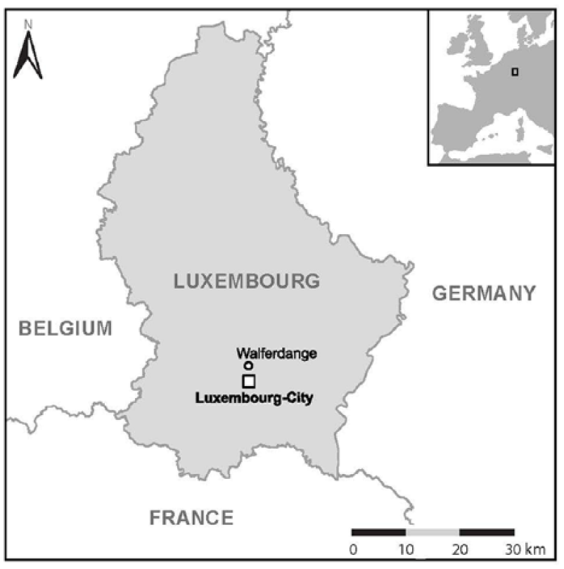
The location of Walferdange in Luxembourg.
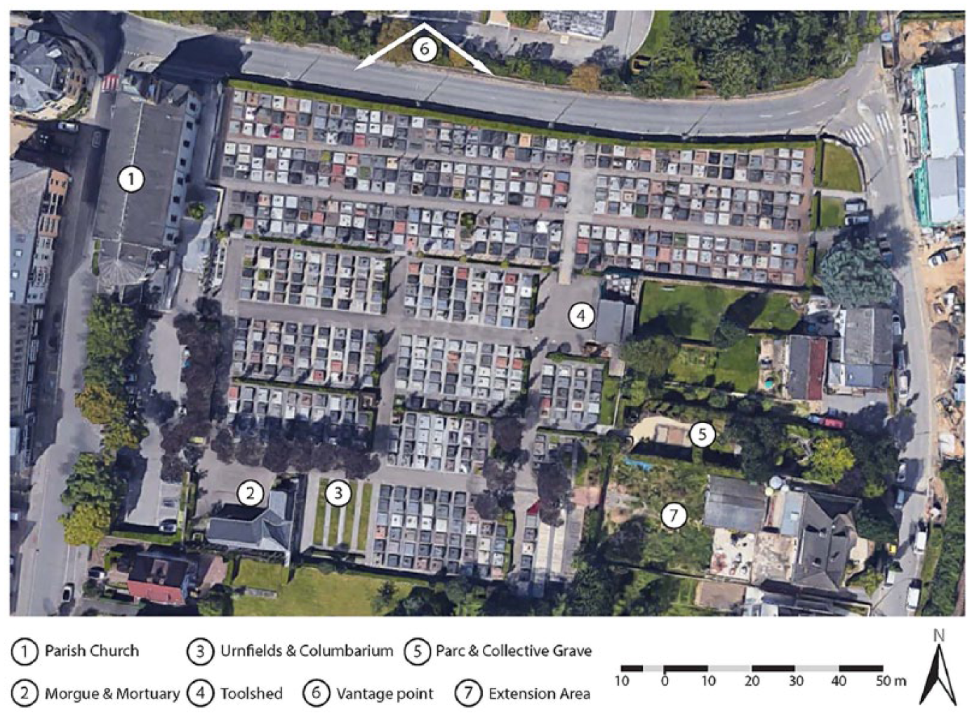
Satellite image of Walferdange Cemetery, ca. 2015. Source: Service technique de la Commune de Walferdange. Scale and explanations added by the authors.
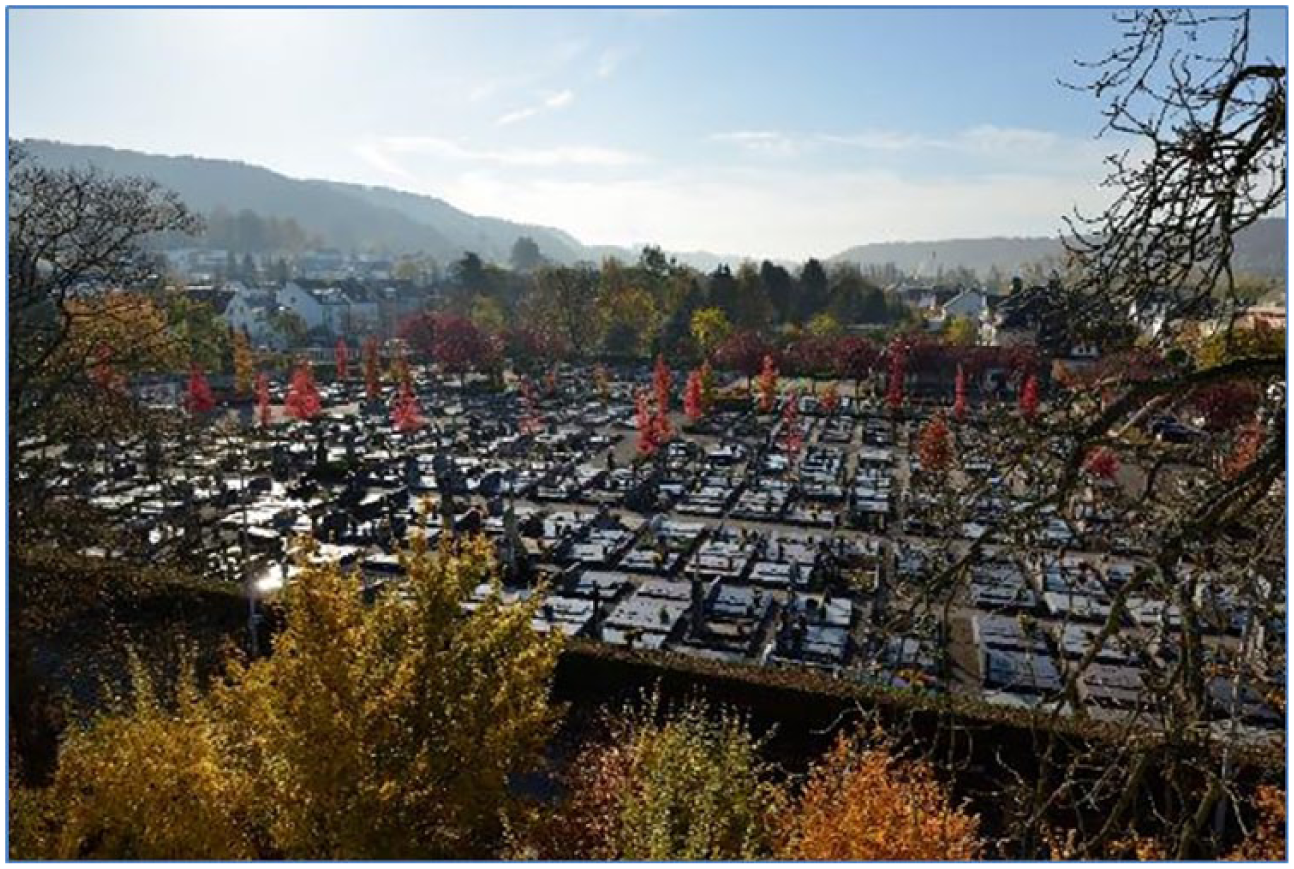
An overview (southern direction, taken from the vantage point indicated on Figure 2) of Walferdange Cemetery (All Saints Day 2016), showing the orderly alignment of the grave plots. Photograph reproduced courtesy of Tom Alesch.
Luxembourg is a small state with a total surface of 2,586.4 km2, a total population of 602,005 and a high ratio (48%) of non-nationals. In 2018, the largest town of the Grand Duchy was Luxembourg city (116,300 inhabitants), followed by Esch-sur-Alzette (35,000) and Differdange (26,200). The degree of urbanization is high (EEA, 2018).There are only three cemeteries with several thousand grave plots (not including the meadow of the crematory of Luxembourg/Hamm): Notre-Dame and Merl in the capital and Esch/Lallange. Cemeteries used to be linked to parishes and/or villages and therefore usually only have 100-plus plots. Our case study, the cemetery of Walferdange, is medium-sized with 739 grave plots (not including the columbarium and the newly erected urn-grave section).
In contrast to the churchyards of the Old Regime, this modern cemetery adjacent to the new Catholic parish church was laid out strictly geometrically between 1845 and 1852. Additional grave sections to the south doubled the cemetery’s capacity after World War Two (National Archives of Luxembourg: ANLux, INT-0077 Cimetières et corbillards/1885-1940 and INT-0083/1892-1937; H-1024-299a-b, 300/1857-1880). These historical data and the cemetery regulations of Walferdange dating from 1910 (Int-003 Division de l’Interieur) from the National Archives were complemented by information kindly provided by the Cemetery administration (Service technique) of the municipality of Walferdange. The latter uses a satellite image (Figure 2) as a basis for grave allocation. Due to data protection issues, we were unable to use the burial register, which would have allowed us to date more graves. Moreover, the dates of death do not reflect the date of construction of a grave, especially in the case of ‘family graves’.
After obtaining official permission to collect data on-site, we first used digital photography and Excel sheets to collect and organize the data, before using this input to develop a beta version of a digital data collection tool specially developed for this purposes. The Cemetery Surveyor Tool (CSA), which the University of Luxembourg (http://transmortality.uni.lu) developed, runs on any Android device (e.g. a smartphone or tablet) and allows a researcher to enter and organize various field data (see Appendix). All the data, including photographs, are linked to a unique ID that identifies each grave and provides an organized table in a comma-separated value (CSV) file format as output for further analysis. Figure 4 provides a screenshot of the user interface. We created and entered a total of 114 variables for the Walferdange cemetery, organizing them into four categories: (vertical) gravestones; (horizontal) grave surface (according to type, dimensions, materials, colours, finish, etc.); additional paraphernalia found on the gravestone and/or grave surface (e.g. crosses, flower arrangements, holy water containers, stonemason marks, etc.); and inscriptions on the gravestone and/or grave surface. Photographs support and document all the features. Figure 5 shows typical photographs taken of each grave during the process. While most data for this particular project still had to be entered and organized manually, for future applications the manual input required is as simple as clicking on an icon, for example, of a pre-specified type of gravestone, or entering measurements; the process today is completely paperless and no extra camera is required.
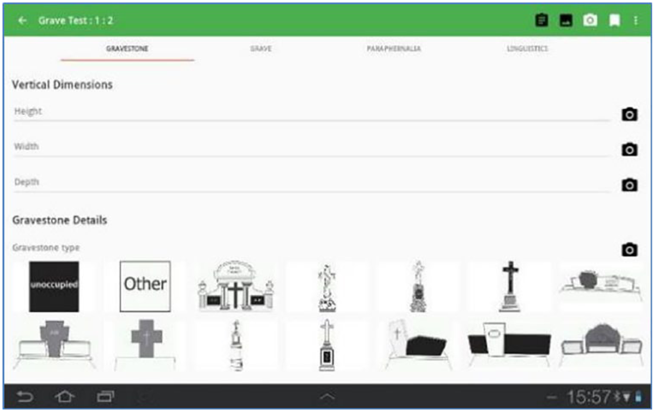
A screenshot of the Cemetery Surveyor Tool (CSA) developed at the University of Luxembourg by Cyrille Médard de Chardon (https://transmortality.uni.lu/Project-RIP/Survey-Tool).
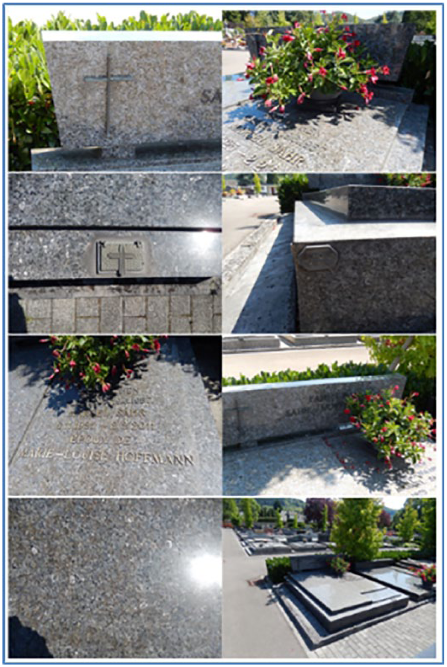
An example of a detailed photograph of a grave at Walferdange (here W-B1).
Most existing typologies of graves, gravestones and any related paraphernalia are based on data collected in the UK or the USA (Buckham, 2000; Deetz, 1996; Mallios and Caterino, 2011, etc.), thus losing relevance when applied to funeral and commemoration traditions of other cultural spheres. Therefore, we had to develop a new typology, but profited from the methodological insights of these studies into the challenges of classification (Whittaker et al., 1998).
During the pilot data collection, which included iterations and methodological improvements, our survey of the graveyard took two researchers working full-time three months (March–May 2016). With the finalized version of the CSA tool, a survey of a similar sized cemetery should only take two to three weeks. We documented 739 graves with 114 variables each and took 3,519 photographs. Figure 6 provides an overview of the number of stones per decade, based on a gravestone’s inscribed date of death, or, in the case of a family grave, on the oldest date.
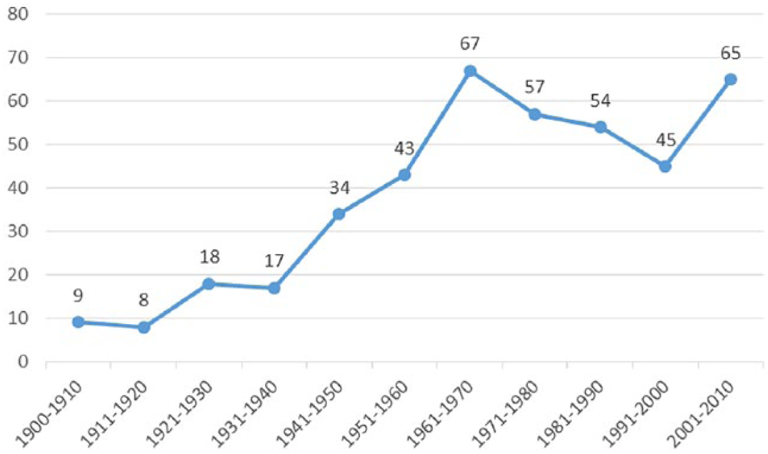
Number of graves (vertical scale) according to oldest date of death indicated on the gravestone (horizontal scale) at Walferdange (N = 417) (note that 322 graves showed no dates).
Data analysis
In order for our data to be comparable and in keeping with established standards in related research, we first used the statistical software RStudio to organize the frequencies of the collected variables and to categorize them. RStudio is a professional and open-source statistical analytical software package that enables its users to check the manually entered data for redundancies, encoding and typing errors and to clean the data. We used the resulting output to identify the top five most common variables and their frequencies. Similar to all prior seminal research, we thereafter ensured we had a diachronical overview of certain variables over time (exemplified by Deetz, 1996). Given that we had 114 variables, we aimed to identify the top five (1) grave types, (2) grave materials, (3) gravestone types, (4) gravestone materials, (5) grave colours, (6) gravestone colours, (7) cross types and (8) holy water container types. Besides showing the chronological developments, we also sought to show how certain variables interrelate. We therefore matched the selected variables in a simple correlation in order to identify further patterns. This is an important step that no previous research has undertaken.
Based on the results, we also identified the most common combinations of grave surface and gravestone paraphernalia. This step was key in respect of using the spatial component to extend the descriptive statistical analysis of the materiality. We used input from the archives, especially the satellite imagery, to match the graves with their geospatial position in the graveyard and their relative positions to each other. We merged the data in QGIS – the free and open geospatial analysis software – with the data organized in RStudio and analysed them geospatially and statistically. We sought to show certain variable and feature hotspots of as well as their correlations and combinations. Our endeavours resulted in heatmaps, which indicate concentrations of selected variables and/or their combinations. We calculated the hotspots by adjusting the software to consider similarities within an 8m radius around each grave — a distance we consider relevant and within the graveowners’ visual range, as we empirically experienced, and which is suggested generally for such a scaled space. According to the software manual (Sherman et al., 2004), GQIC’s heatmap function ‘uses Kernel Density Estimation to create a density (heatmap) raster of an input point vector layer. The density is calculated based on the number of points in a location, with larger numbers of clustered points resulting in larger values.’
We included undated graves and graves with no headstone in the spatial analysis since the absence of such a stone could be a conscious choice. Qualitative social research may allow us to find out more about consumer choice. This is not the focus of the present article, but it may be useful to briefly outline our overall research design at this stage. The first step is to make salient objects ‘speak’, meaning that the spatial analysis of the cemeteries’ material ensemble was approached in an inductive way by the collection of quantitative object-related data. This allows us to develop certain hypotheses in a ‘grounded theory’ approach. The cemetery of Walferdange was singled out for the pilot study, followed by a dozen fully investigated burial places in Luxembourg and neighbouring Germany and France (Graas, 2017; Streb, 2019). In Walferdange we also conducted expert-interviews with members of the cemetery administration and technical service; four spontaneous investigative interviews with grave owners at the site, followed by expert-interviews with the two foremost stonemasonries of the area. After the survey, the cemetery of Walferdange also became the place for a video-based eye-tracking experiment. Using mobile devices (including a retroreflector), we simulated typical sales negotiation/conversation for designing a fictive grave on a vacant plot (Schmitt et al., 2018). The most relevant result: both the (real) stonemason and the (fictive) ‘clients’ used the living cemetery as open air-showroom and reference for their design decisions.
Quantitative-spatial findings
The spatial concentrations of certain materials, grave designs and markers allow a more detailed chronological analysis of their distribution. As mentioned above, previous research in this field has mainly relied on such a chronological frequency analysis of certain grave features to determine sociocultural, or even socioeconomic, transformations over time. In a first step, we submit our data to this rather conventional analysis and then compare the outcome with that of a spatial analysis.
As Figure 7 shows, granite has always strongly dominated all other materials during the observed time horizon. Based on the premise that there is no material bias in the ‘surviving graves’ sampled in 2016 and that they are representative of their construction time, the results are as follows: gneiss experienced a strong revival between 2001 and 2010, when migmatite also became more common. Gravel appears to be a typical material choice in the 1960s. Between 1981 and 1990, granite reached an all-time peak; a wider choice of material only slowly complemented it later on. Bluestone, which peaked in the 1950s, had virtually disappeared by 1990. The entire observation allows one to deduce the development of granite dominance over time, the almost complete substitution of bluestone and a general trend towards a higher variety of materials in cemeteries over time. Figure 8 shows the top five (by count) grave types over time. Again, the 1a-stepped (raised) type appears to clearly dominate during most periods, continuously peaking between 2001 to 2010, when it comprised by far the majority of grave types. While other grave types have always existed, they appear to have been part of a far less visible trend. For instance, the grave type 1f-stepped (middle plate shorter) type shows several peaks during the 1920s, 1940s and, finally, between 1971 and 1990. The 3b-half-sarcophagus (cover stone) type peaked during the 1960s. There were larger numbers of the 1e-stepped (2 plates) second type under scrutiny in the spatial analysis during the 1940s, peaking during the 1970s and again briefly during the first decade of the 21st century.
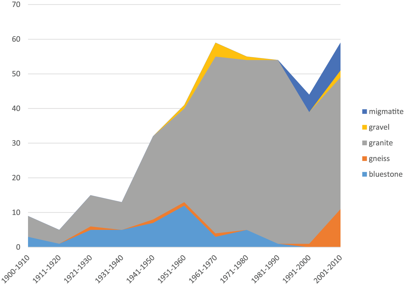
Number of top five grave material types (vertical scale) and their chronological distribution (horizontal scale) at Walferdange over decades (excluding undated and/or empty plots, N = 386).
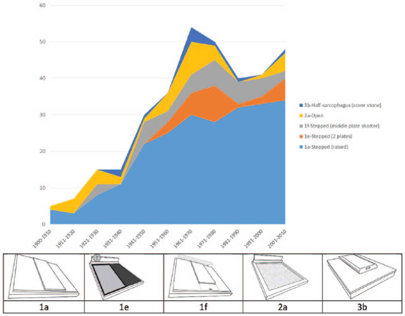
Number of top five grave types (vertical scale) and their chronological distribution (horizontal scale) at Walferdange over decades (excluding undated and/or empty graves, N = 341).
There is a far greater variety of holy water containers, potentially a feature that in itself is specific for the examined region. Figure 9 shows the top five (by count) types of this particular paraphernalia identified during our data collection. Again, different types appear, peak and disappear during specific periods. Firstly, all of the top five container types have more or less been present at the cemetery during the entire period under research. It is worth tracing the chronological distribution of one of the containers, the 4a-knob-rectangular type in greater detail. It clearly comprised a relatively large share of all holy water container types on pre-1900 graves, which makes it a fairly ‘typical’ design. It almost disappeared during the 1920s, before eventually peaking during the 1950s. Thereafter it declined sharply, eventually disappearing by 1980.
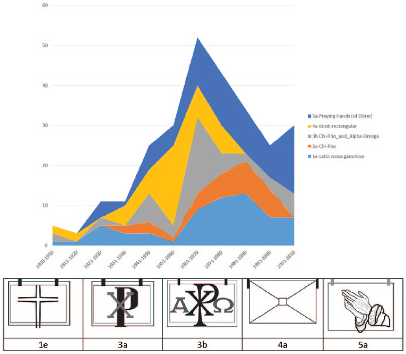
Number of top five holy water container types (vertical scale) and their chronological distribution (horizontal scale) at Walferdange over the decades (excluding undated, empty graves, or lost holy water containers, N = 285) (note: they are usually small, usually have a lid, and are made of bronze or brass, contain holy water and are firmly fixed to the slab/curb of an individual grave).
Similar to the above graphs, we can, like previous studies, produce very similar ones to diachronically depict the rise, peak and – potential – decline of specific grave features. We could also examine other variables and place these into the context of sociocultural and/or socioeconomic developments and – eventually – draw connections between the materials and changing habits. However, there is a fundamental flaw in this approach: the graves’ construction dates are often unavailable (almost a third in our case) or impossible to verify, as the design may have been altered over the years when other occupants were added. Merely using chronology to account for trends in materiality seems scientifically unsound.
We therefore complement this approach by using a geospatial analysis, which renders frequencies visible in space and traces similarities in design. Contrary to chronological charts, maps also allow us to include graves built before 1900 and after 2010.
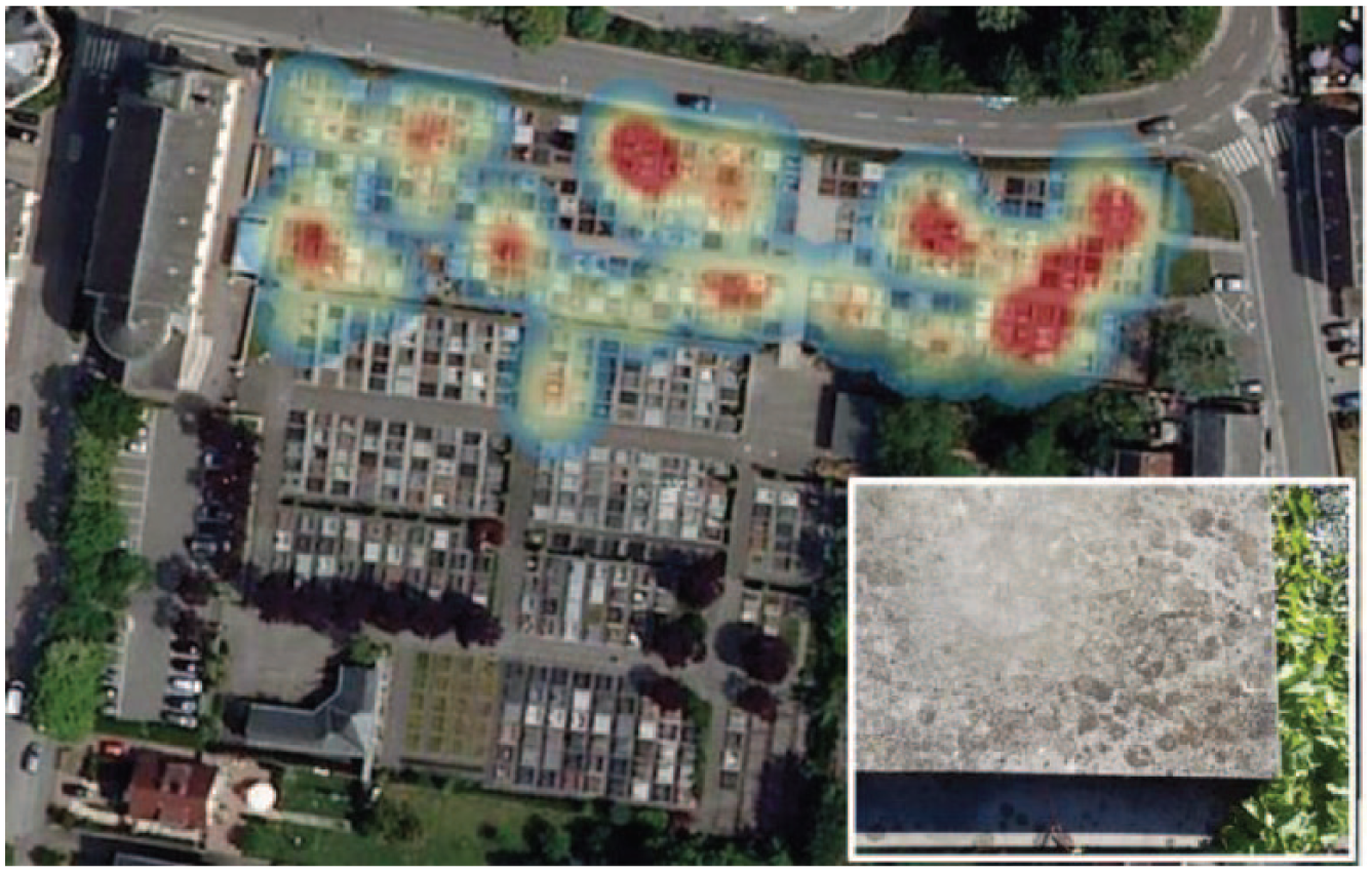
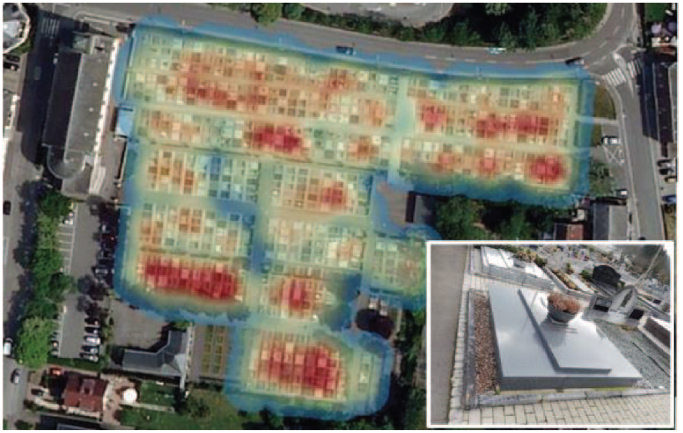
Figure 10 maps concentrations of granite grave material, i.e. the main material of the horizontal grave surface. Granite is clearly an omnipresent material choice that is well spread throughout the cemetery; however, some areas have higher concentrations than others. This phenomenon becomes clearer when one considers bluestone as another horizontal material. Figure 11 clearly indicates that this particular material is only present in the northern part of the cemetery, again with certain concentrations. Most importantly, the southern part contains no bluestone.
The concentrations of granite graves (N = 514) at Walferdange.
The concentrations of bluestone graves (N = 58) at Walferdange.
By combining information from the chronological chart (Figure 7) and spatial analysis (Figures 10 and 11), we conclude that although the northern part is the oldest, bluestone mostly ‘survives’ in graves dating from 1940s to 1960s, because the oldest graves were re-used and often rebuilt by new grave owners who then used granite. The granite hotspots in the northern part reflect this finding.
Moreover, granite is not as ‘dominant’ everywhere as the diachronic chart (Figure 7) would suggest. There are clear pockets of granite, which may point to neighbouring and/or emulation effects on the choice of materiality, since the same material is used in close spatial proximity. A comparison with other cemeteries, using the same tool, may verify the hypothesis that space matters more than time. This type of analysis is especially useful when there are no or few archival records on the evolution of the cemetery.
The heatmaps of certain grave models (Figures 12 and 13) and accessories (Figure 14) confirm the utility of combining diachronical and spatial indicators. The chronological chart (Figure 8) shows a growing preference for the 1a-stepped (raised) grave type. However, the heatmap reveals that there are explicit areas of concentration, again indicating a certain neighbouring effect. Conversely, the second most prominent grave type (1e-stepped (2 plates) is found in a particular part of the cemetery, together with graves from the 1980s and 1990s.
The concentrations of the 1a-stepped (raised) grave type (N = 382) at Walferdange.
The concentrations of the 1e-stepped (2 plates) grave type (N = 54) at Walferdange.
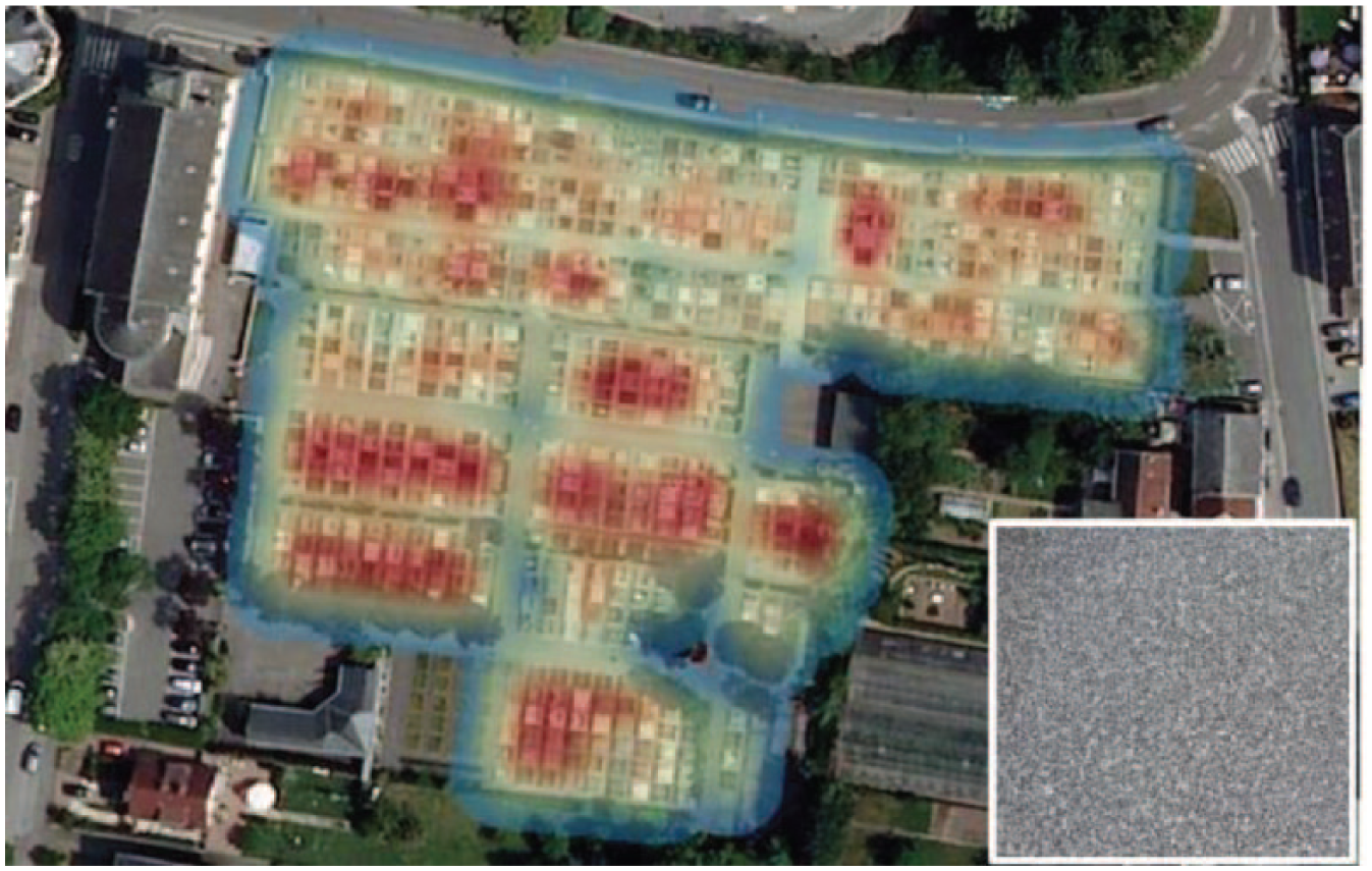
The concentrations of the 4a-knob-rectangular holy water container type (N = 67) at Walferdange.
This spatial analysis becomes even clearer when examining the distribution of a certain type of holy water container, a common sight in Luxembourg cemeteries. The 4a-knob-rectangular type only appears in the northern and central parts of Walferdange, with hotspots concentrated in the far north-eastern corner. Again, the spatial consideration of certain grave features could lead to interesting hypotheses, especially if, as in seminal studies, this consideration is combined with the conventional approach of tracing material features’ frequencies over a specified time horizon. While the spatial concentrations of such features are clearly linked to time, this does not fully explain all the areas of high concentration, since all choices of materials and/or material types have generally been available for this grave population throughout the researched period.
Consequently, the spatial explanations for certain concentrations of grave designs need to be explored, as these could be due to, for example, neighbouring effects, i.e. deciding on certain features because they appear on the graves close by. The observed concentrations thus support the hypothesis that concentrations of certain grave features are no coincidence, but are due to the conscious or unconscious actions of numerous agents, resulting in a unique assemblage of individual decisions comprising the cemetery as a material culture and a space. A deeper understanding of such agency might be key to fully understanding what we could learn from such materiality and spatiality in previous and current societies.
Discussion
When considering the interrelationships between all three dimensions (grave type, grave material and holy water container type) in their entirety, it becomes apparent that the observed spatial concentrations of each separate feature do not necessarily overlap. A simple calculation can reveal this. The two most prominent combinations are C1 (granite with a 1a-stepped (raised) grave type and a 5a-praying hands type of holy water container) and C2 (granite with a 1a-stepped (raised) grave type and a 1e-Latin cross gammion type of holy water container), which together form 33.25 percent of all graves.
A traditional chronological analysis of these two combinations (C1 and C2) allows us to shed light on another challenge: the usage of the dates of death inscribed on the gravestones.
The difference between the oldest and the newest date on a gravestone (see Figures 15 and 16) points at the difficulties underlying all chronological charts: up to nine people can be buried in one grave at any period for which the grave has been paid. In addition, graves can be refitted after decades of use, or can be refitted when sold. A grave can therefore undergo significant design transformations over time, rendering the general dating and the dating of specific design features imprecise. The only reliable finding is that, during specific periods, specific design features and/or types of grave, gravestone, paraphernalia, etc. appear, peak and decline. Having to rely on just this data, makes determining at which time a certain feature was added almost impossible.
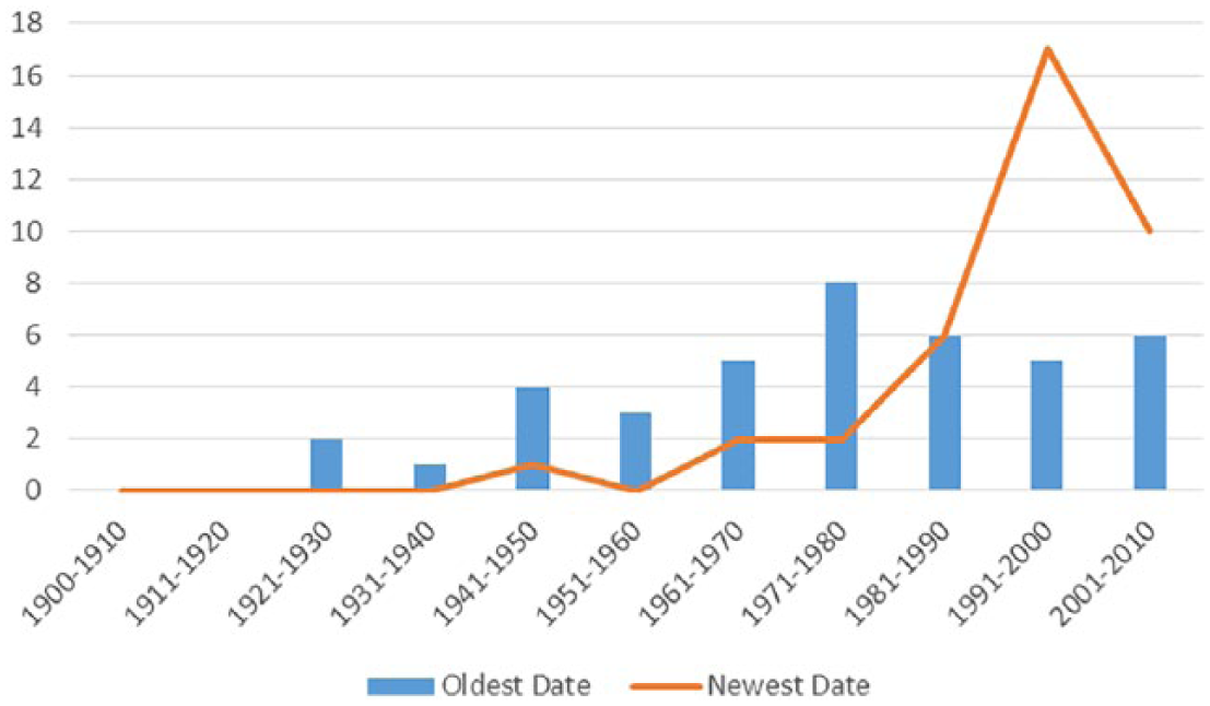
The chronological frequency of C1 graves made of granite, type 1a-stepped (raised), and 5a-praying-hands holy water container type at Walferdange (# vertical scale, dates horizontal scale).
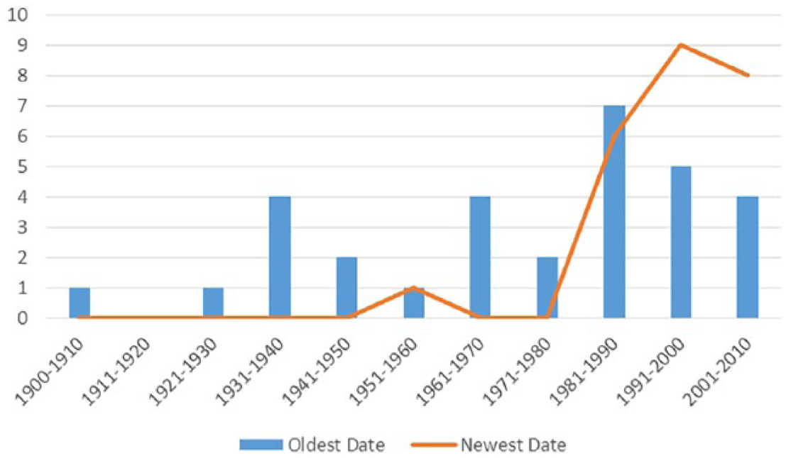
The chronological frequency of C2 graves made of granite, type 1a-stepped (raised), and with the 1e-Latin-cross gammion holy water container type (# vertical scale, dates horizontal scale).
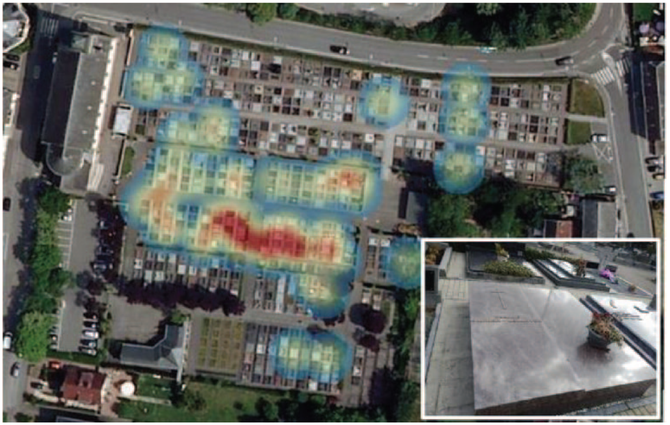
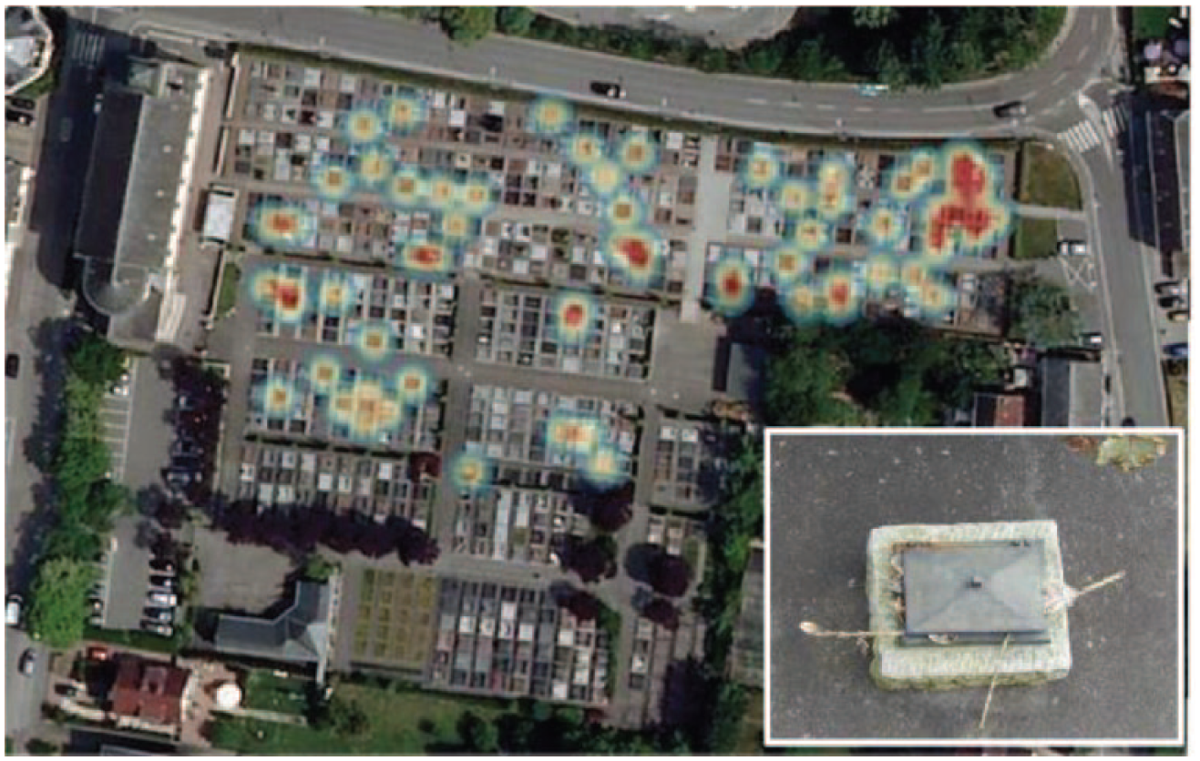
The Figure 17 heatmap shows that C1 graves (granite with 1a-stepped (raised) headstones and 5a-praying hands holy water basins) are found almost all over the cemetery. However, there are several high concentrations in the older, northern part. By comparison, C2 grave types (similar but with 1e-Latin cross-gammion holy water basins) are concentrated in the southern, more recently developed, part of the cemetery (Figure 18). This is far more obvious than on the chronological chart above. This reinforces our hypothesis that there is not only a time-dependent choice of materials, but also a neighbouring effect.
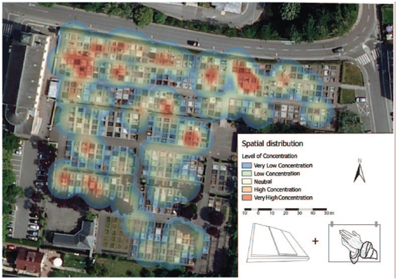
The concentrations of C1 graves made of granite, type 1a-stepped (raised) and 5a-praying hands containers at Walferdange.
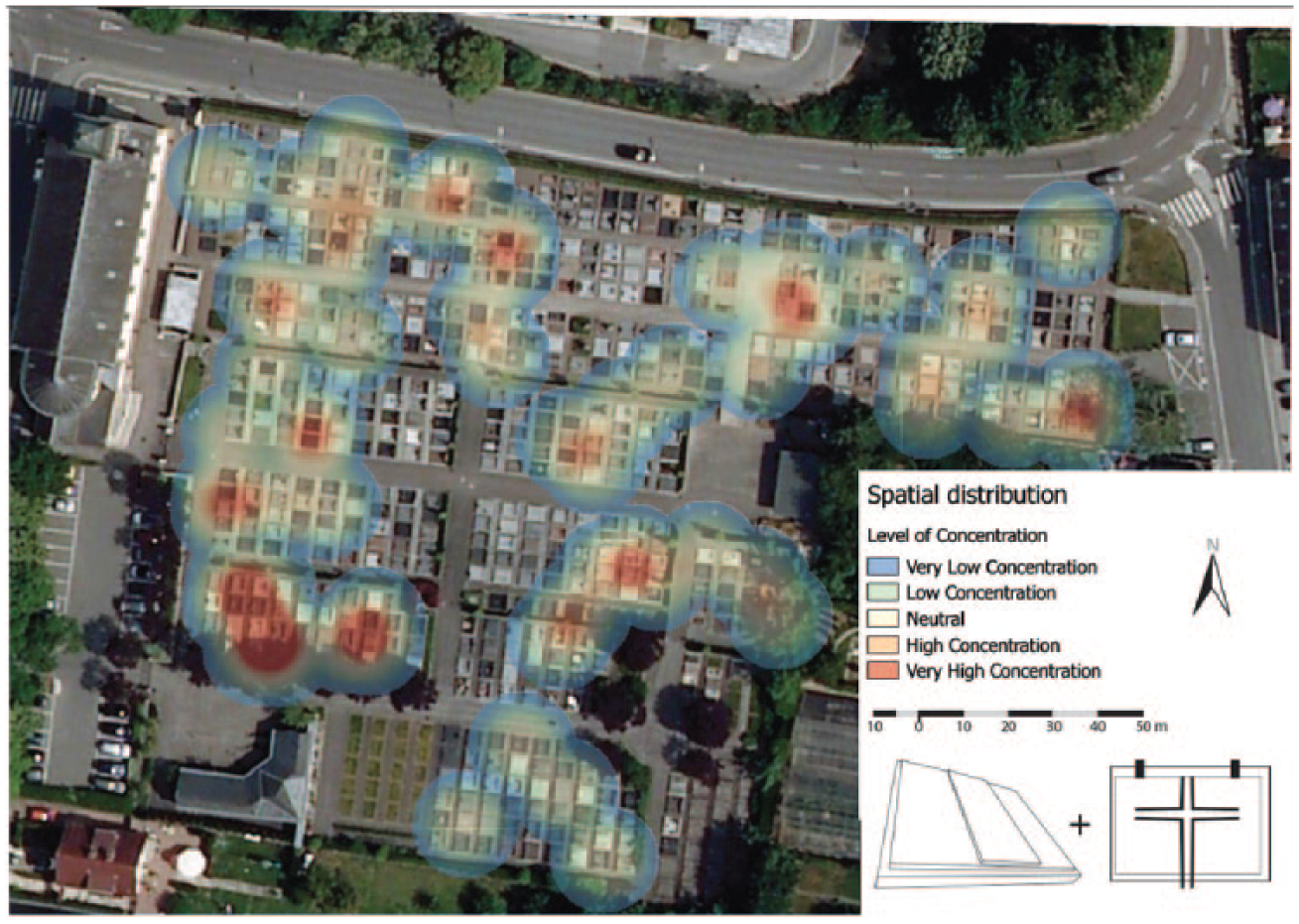
The concentrations of C2 graves made of granite, type 1a-stepped (raised) and 1e-Latin Cross-gammion at Walferdange.
While the chronological charts (Figures 15 and 16) show that neither of these two types has been around during the entire period under examination, the heatmaps prove that this design is not limited to new graves, but was also applied to older graves, potentially when new bodies were added to the grave and/or during refitting, which is why they show up throughout the cemetery. This would also mean that the newest (not the oldest!) date is a potentially better indication of the dating.
The observed spatial concentration of these features also support our finding that, during certain periods, people chose the same grave features as those found close by. This observation indicates that we do have a concentration in time and in space. Besides the strong interrelatedness of certain grave features, which may be responsible for the modern cemetery’s general homogeneous appearance, certain feature types appear at a certain time, spread via a neighbouring effect and become spatially concentrated in certain areas of the cemetery. The interrelated agencies of materials, space and people co-create the unique heterotopia referred to as a cemetery.
Conclusion
After applying a somewhat work-intensive approach with comparatively complex statistical computing analysis and graphic presentation, the main conclusion seems unspectacular at first glance: the immediate material proximity of things influences the material design of single grave plots and vice-versa. In other words, we link a material trend analysis of sepulchral design to its micro and medium spatial setting, seeking to explain the growth of trends, fashions and fads.
Cultural studies investigate material modes, customs and fashion by asking why certain styles are popular and deemed socially appropriate and others not. While such ‘trends’ are observable in a sociological or ethnographical context they are very hard to measure: counting and classifying the results and entering the records chronologically on a timeline do not yet offer an explanation. Consequently, we first added the factor ‘space’ to our calculation. In the case of graveyards, the literal ‘manufacture’ of space includes the production of a material culture and an engagement with norms, traditions and new trends. These processes are inseparable and their practices interdependent. A ‘trend’ is not only linear and progressive; by recalling its etymology (from the Old English trendan: to revolve, to rotate), we want to emphasize that a trend also has a spatial component – it gravitates towards certain areas more than others, forming ‘hotspots’ of objects. Given this strong presence of things, another factor represented a challenge for us – the ‘absence’ of people. Cemeteries are densely populated, but only by the dead. While grave owners are usually absent, their design and decoration of the graves as well as their chosen materiality are very present. We adapted our research design to this dominant face-to-thing situation by drawing on archaeology – the social science that engages most directly with material culture, often without people and written sources. Akin to contemporary archaeology, we combined our findings and fine-tuned our questions by talking to people and consulting archival records. We conducted interviews with experts (mainly local stonemasons and cemetery administrators) and ‘users’, i.e. grave owners, while exploring and charting the material culture in parallel. This article, however, has focused on the archaeological, not the ethnographical, methodology. The latter may also point us in the direction of neighbourhood effects (Schmitt et al., 2018), but the question was whether we could prove this by means of quantitative methods.
Is this combination of diachronic and spatial analysis transferable to other fields? We think so, particularly to studies of the recent and contemporary past and to those of any face-to-thing rather than face-to-face situation, whether in a public or semi-public setting (like architecture, the design of front gardens, market stands and retail). Like a cemetery, the spatial ‘contamination’ of trends could be investigated in all kinds of micro to medium spatial settings dealing with material series.
Footnotes
Appendix
The Cemetery Surveyor Tool allows for collecting data and photographs of the graveyard and its surroundings, in order to gain an impression of the graveyard as a whole. The tool was developed in two forms, both of which are open-source. An Android tablet optimized version was created in 2015/2016. This application allows the device to be taken into the field, take pictures, and complete a predefined survey on-site. The data can be exported and then provides a database of cemeteries, subsections, and graves with all their attributes and photos linked together. Beyond allowing statistical analysis, a catalogue of graves or individual features in pictures is possible. When joined with the spatial associated file, spatial analysis of features distribution is also possible. The application is freely available on the Google Play Store (play.google.com/store/apps/details?id=net.frakturmedia.cemeterysurvey) and can also be modified, updated or altered in any way as the source-code is available (github.com/serialc/CemeterySurveyor). Extensive documentation exists to support (re)development and use (github.com/serialc/CemeterySurveyor/raw/master/Documentation/documentation.pdf). In 2017, the second application was developed. It is similar, also allowing the export of data for analysis, but web-based and contains additional features (e.g. survey customization, multiple projects, multiple concurrent users). This application is also available freely to install and modify with the source code also freely available (github.com/serialc/WebCemeterySurveyor).
Funding
This research received no specific grant from any funding agency in the public, commercial, or not-for-profit sectors and there is no conflict of interest.
Author biographies
![]() ). Moreover, he is interested in the materiality and heritage of 20th century conflicts in the German Palatinate. For his research he applies historical-archaeological methodology, focusing on the development of modern identity and ideology.
). Moreover, he is interested in the materiality and heritage of 20th century conflicts in the German Palatinate. For his research he applies historical-archaeological methodology, focusing on the development of modern identity and ideology.
Email:
![]() ).
).
Email:
Email: