
Abstract
In the context of global warming, ice patches are increasingly important foci of high-elevation archaeology. Langfonne in Jotunheimen, central southern Norway, is uniquely suited to provide a window onto site formation processes and taphonomy in this novel archaeological setting. Here the site record from systematic survey includes the largest number of arrows, bones and antlers from a single ice patch worldwide. Combining data from these finds with the results of glaciological investigations provides an opportunity to interpret the influence of archaeological site formation processes and taphonomy on chronological and spatial patterning. It is inferred that the spatial patterning of artefacts at Langfonne is partly a result of displacement by ice movement, meltwater and other natural processes. Nevertheless, the finds yield information regarding past hunting practices and the extent of ice at different times. An early cluster of finds from c.6000 cal yr BP may result from ice deformation which has brought early objects to the surface. The number of arrows increases from c. 1700 cal yr BP onwards, peaking around c.1200 cal yr BP. Artefacts from this period show a wide spatial distribution indicating both the preferential survival of more recent finds and that they were lost when the ice patch was large. Based on comparison with the chronology of natural bone and antler samples from the site, the greater number of finds of this date may also reflect a period of increased hunting.
Introduction
Glacial archaeology is a new field in archaeology brought on by climate change (Andrews and MacKay, 2014; Dixon et al., 2014; Reckin, 2013). Melting mountain ice has released large numbers of artefacts. Most of the finds of archaeological interest are from semi-stationary ice patches underlain by (discontinuous) permafrost that may preserve ice thousands of years old (Farnell et al., 2004; Jarrett, 2019; Meulendyk et al., 2012; Ødegård et al., 2017).
The definition of ice patches in the literature is vague and often contradictory (Serrano et al., 2011). In this paper, we follow the broad definition put forward by Ødegård et al. (2017): perennial snowfields and glacierets. Ice patches are mostly stagnant and do not convey mass downslope from an accumulation area to an ablation zone like glaciers do, although they may show slow internal deformation (Jarrett, 2019; Ødegård et al., 2017). In addition, they do not have a firn area like glaciers, as the transformation of snow to ice happens through rapid metamorphism and refreezing of meltwater (Kawasaki et al., 1993).
In contrast to ice patches, the constant renewal of the ice in glaciers normally prohibits the preservation of archaeological finds older than c. 500 years (e.g. Hebda et al., 2017; Providoli et al., 2016). Even inside the ice, the stress and strain of glacier movement tears objects apart. Basally sliding glaciers would also destroy and/or bury artefacts lying on the ground.
The terminology used for ice patches and glaciers can nevertheless be problematic in archaeological research. This is because ice patches may become glaciers during periods of increased size and vice versa. Glaciers may also have sections with stationary ice along the upper edges. Although we adopt the term ice patch (broadly defined) for Langfonne, during some time periods (e.g. during the ‘Little Ice Age’) it was probably a cold based glacier.
For the last two decades, archaeologists in North America, the Alps and Scandinavia have surveyed ice patches for artefacts emerging due to melting. Most of the finds connected to human activity derive from hunting or transport. The ice patches also contain faunal remains, such as bones, mummified birds, rodents and even insects (Rosvold, 2018). Finds are typically discovered lying on the lichen-free ground close to the retreating ice, whereas finds discovered on the surface of the ice are less common. Archaeological ice patch sites are quite varying in nature, both in their topographical expression and in the number and age of recovered artefacts. Usually, the sites have only a few finds (e.g. Andrews et al., 2014), but some have hundreds (e.g. Hafner, 2015; Pilø et al., 2020). A few large sites show chronological and/or spatial patterning of the finds (e.g. Pilø et al., 2020).
Before interpreting chronological and/or spatial patterning with respect to human activity and past changes in the size of ice patches, understanding the influences of archaeological site formation processes and taphonomy is essential. Archaeological site formation processes create and subsequently transform archaeological deposits. Taphonomic processes, initially defined by Efremov (1940) as those geological and biological phenomena that transform animal remains during their transition from the biosphere to the (sub)fossil record, can ultimately obliterate archaeological objects (both artefacts and ecofacts), often differentially depending on raw material and context (Surovell et al., 2009). In an ice patch environment, these processes are potentially very different from normal archaeological site formation and taphonomic processes (e.g. Schiffer, 2002; Surovell et al., 2009). The ice patch sites are situated in cold, high mountain environments; the finds are influenced by slow ice deformation, repeated ice melt and refreezing, meltwater transportation, displacement by strong winds and burial by active paraglacial processes. How do artefacts and faunal remains decay over time, fragment and move in response to these natural processes? There is little published literature regarding archaeological site formation processes and taphonomy on ice patch sites. Farbregd (1983) discussed briefly how meltwater transport of arrows can lead to poorer preservation of arrows in front of the ice. Farbregd (1972) and Martinsen (2016) looked at ice deformation and how it could potentially influence the chronological distribution of preserved finds. Callanan (2015) identified chronological and spatial patterns on a regional level and discussed how these patterns may be influenced by previous melting periods. Rosvold (2018) discussed the taphonomic processes affecting faunal remains from ice patches.
The present paper augments this earlier work by spatial and chronological analysis of a large assemblage of systematically recovered finds from a location that has also been a focus of glaciological investigation. The Langfonne ice patch in Innlandet County, Norway, is uniquely suited for a first detailed case study of site formation processes on ice patch sites, including the taphonomy of finds. It has a high number of artefacts (121) in varying states of preservation, a deep chronology going back 6200 years, and a matching record of natural palaeozoological material (290 finds of bone and antler). The local glaciological record of ice advance and retreat in Jotunheimen is well documented (Gunnarsdóttir, 1996; Matthews and Dresser, 2008; Velle et al., 2010), and there has been glacial geological investigation of Langfonne itself (Grønås, 2019). Moreover, the archaeological record from the site shows discontinuous and intriguing chronological and spatial patterning.
This study asks to what degree these chronological and spatial patterns are influenced by site formation processes including taphonomy? Taking these processes into account, can the find distribution nevertheless yield information on the organisation and chronology of human activity (mainly hunting) at the site, and the size of the ice patch, at various times during the Holocene? These are fundamental and previously unanswered questions, for Langfonne and in the field of glacial archaeology more generally.
The Langfonne ice patch
Langfonne is situated in the Kvitingskjølen massif in the north-eastern part of the Jotunheimen Mountains (61.762O N, 8.743O E), at a height of 1740-2030 m.a.s.l. (Figure 1). Langfonne is within the mountainous permafrost zone, and below the regional temperature-precipitation equilibrium-line altitude (TP-ELA). Temperature measurements from Juvvasshøe meteorological station (1894 m.a.s.l., 22 km to the southwest) show an average temperature of –4.6°C, with only June, July and August having a positive average temperature (Grønås, 2019).
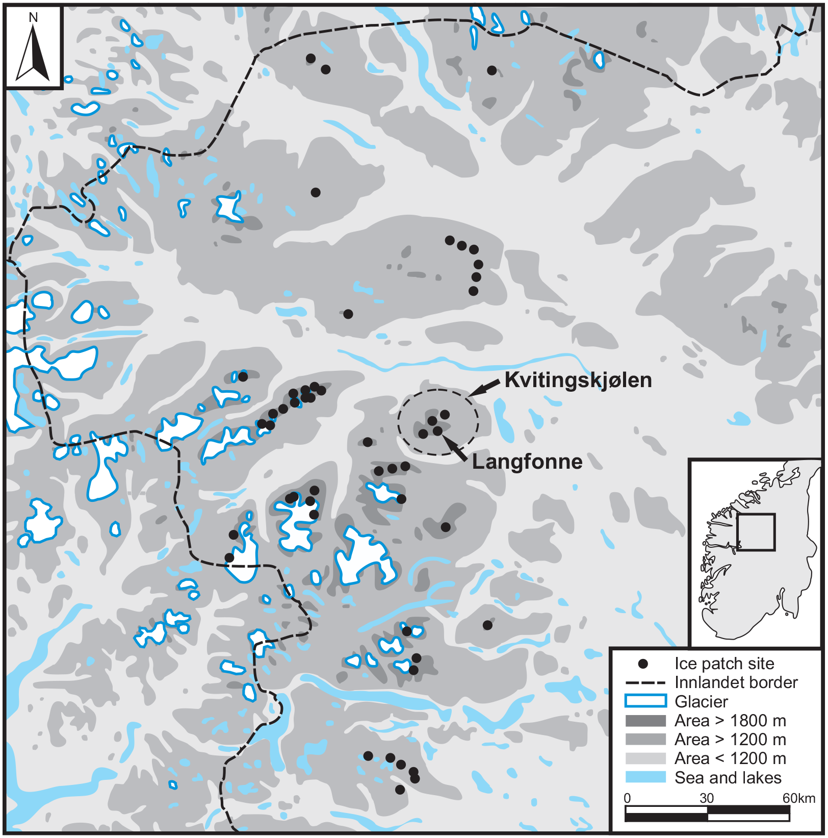
Map of ice sites in Innlandet County with Langfonne and Kvitingskjølen marked. Drawing: Lars Pilø.
The ground surrounding the ice is mostly covered in scree (washed-out till deposits) with some patterned ground and a few outcrops of bedrock. The tree limit in the area is around 1000 m.a.s.l., and the only vegetation near the ice patch is moss, lichen, grass and flowers (Grønås, 2019).
During the ‘Little Ice Age’ (c.1450–1920 CE), the ice covered c.2.5 km2 based on lichenometry combined with orthophotos (Grønås, 2019). Our measurements, based on orthophotos, of the present-day ice and the surrounding lichen-free zone (LFZ) show an estimated recent size of well over 800,000 m2. The present LFZ probably shows the ice extent in the mid/late 1990s (Grønås, 2019), after some winters of heavy snowfall caused by a prevailing positive North Atlantic Oscillation (NAO) winter weather mode (Nesje and Matthews, 2012).
In 2014, melting had led to the break-up of the ice into three separate patches – A (66000 m2), B (14000 m2) and C (162000 m2) (Figure 2). These totalled about one tenth of Langfonne’s estimated maximum extent during the ‘Little Ice Age’. Ice patch A is situated at 1905–2030 m.a.s.l., and measures 280 m upslope and 350 m in width. Ice patch B is situated at 1900-1950 m.a.s.l. and measures 150 m upslope and 100 m in width. Ice patch C is situated at 1740-1890 m.a.s.l. and measures 250 m upslope and 810 m in width. All three ice patches have an average slope angle of c.20°. Ice patches A and B face east-southeast, which is rare for ice patches, as they normally face east to north (aspects with less exposure to the sun). Ice patch C faces east-northeast.
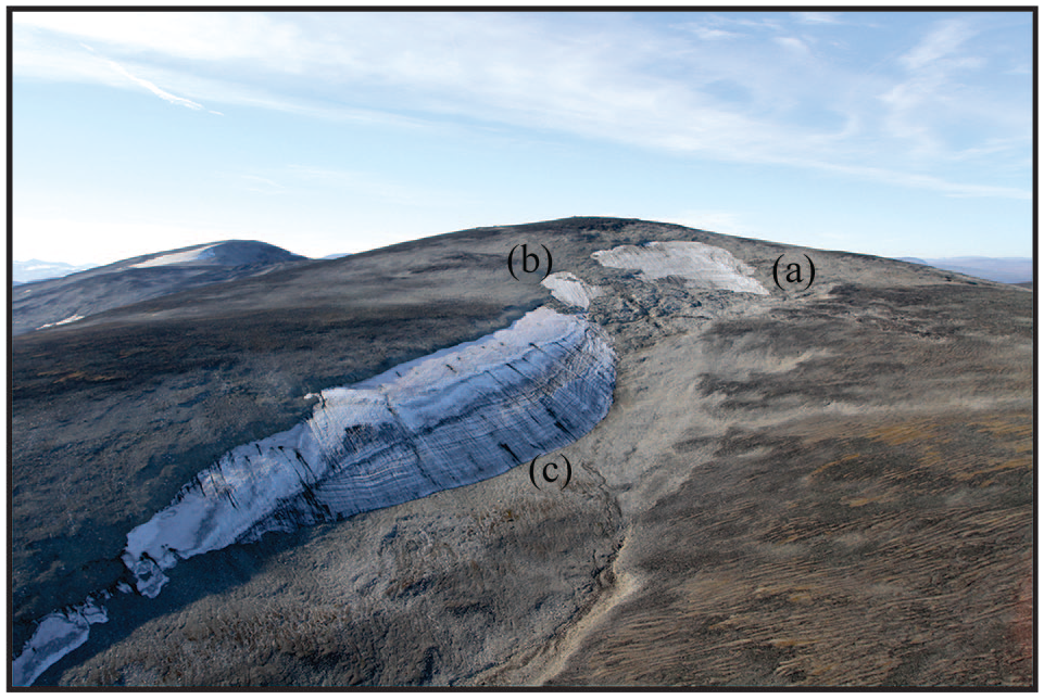
Oblique aerial photo showing the three separate main ice patches (a–c) on 16 September 2014. Photo towards northwest. Photo: Lars Pilø.
Measurements from Juvvasshøe meteorological station (1894 m.a.s.l.) 22 km west-southwest of Langfonne, show that the dominating wind direction is west to southeast. Based on local topography, Langfonne would be in the wind shadow for westerly winds, while south and south-easterly winds would hit the ice patch directly (Grønås, 2019). The Juvvasshøe station has measured maximum sustained wind at 44 m per second with gusts up to 64 m per second (Kvamme and Abildsnes, 2012).
Glacial striations, flutings and other signatures of basal sliding were not observed during the thorough archaeological surveys around Langfonne. In front of Langfonne C, however, some periglacial features (elongated patterned ground) are present. Thin laminations are present in ice patch C. Observations indicate that these thin layers are likely to have been compressed in situ from the weight of overlying snow, and not formed by basal ice processes. In this climate, the transformation from snow to ice takes a few years with a typical volume reduction of more than 50% (Kawasaki et al., 1993). In ice patch A, the ice-layering follows the bottom topography, as has previously been observed from ground penetrating radar (GPR) survey at Juvfonne, another ice patch in the region (Ødegård et al., 2017).
Methods
Archaeological fieldwork
Archaeological fieldwork at Langfonne started after the remarkable discovery of a hide shoe (dated to 3370–3180 cal yr BP, Table 1) in 2006 (Finstad and Vedeler, 2008). The site was visited by archaeologists on several occasions after that, and artefacts were recovered each time. In 2014 and 2016, almost the entire site was systematically surveyed with a 2-m interval between archaeologists methodically looking for artefacts and palaeozoological materials. A total area of c. 180,000 m2 was systematically surveyed (Pilø, 2020) and all discovered artefacts and palaeozoological materials were recovered. Finds were geolocated using a CPOS-GPS giving measurements with precisions of c.10 cm or c.1-2 m in contexts with and without stable cellular phone coverage respectively. At Langfonne, cellular phone reception was variable. A few finds recovered prior to 2014, and during monitoring after the systematic fieldwork in 2014, were measured using a handheld GPS with a precision of 5–8 m.
Radiocarbon dates of artefacts, including two pieces of antler exhibiting cut marks.
Radiocarbon dating
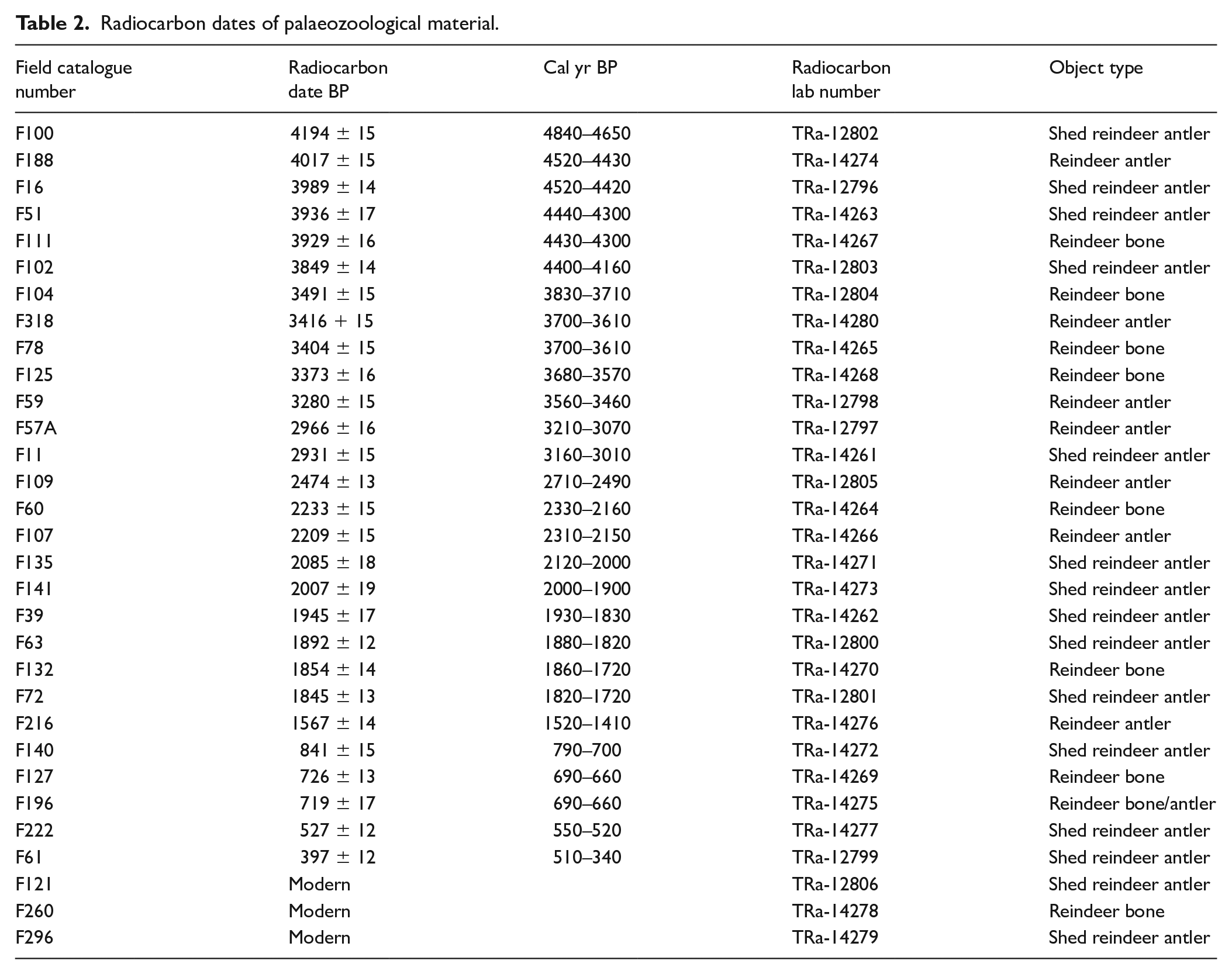
A total of 102 radiocarbon dates have been undertaken on the find material collected from Langfonne, 71 on artefacts and 31 on palaeozoological samples of bone and antler. All dates are calibrated using OxCal version 4.3.2 (Bronk Ramsey, 2017) with the IntCal13 atmospheric curve of Reimer et al. (2013), decadal rounded and are given at 95.4 per cent probability. We have implemented kernel density estimation (KDE) in addition to traditional summed radiocarbon plots to be able to determine the distribution of radiocarbon dated events without the confounding effects of spurious peaks from the shape of the radiocarbon calibration curve (Bronk Ramsey, 2017). Only a small subsample of the large corpus of palaeozoological material was dated, including only antlers and other identifiable bones of reindeer (Rangifer tarandus), with a focus on ice patches A and B where most artefacts were found.
Six bulk sediment samples from the ice were also dated. Sediment trapped within the ice and on its surface derives from two main sources – animal dung (primarily reindeer) and wind-transported material, mainly organic remains and fine-grained minerogenic particles from the surrounding terrain. This material is commonly concentrated as dark layers in the ice. In general, these bands are chronologically mixed melting horizons, where overlying layers melted and concentrated all material in one dark zone (Jarrett, 2019; Meulendyk et al., 2012). Bulk sediment samples from exposed dark layers have been collected, where they were exposed at or near the surface of the ice. Such samples carry risks of contamination from windblown old carbon, leaching of organic carbon from the surface into subsurface ice through ice-crystal veins and glacial microorganisms. Nevertheless, two radiocarbon series from stratigraphically superimposed dark ice layers in comparable ice patches – Kringsollfonne (surface sampling) and Juvfonne (ice tunnel sampling) – have shown that they are consistently younger further up the ice column (Jarrett, 2019; Ødegård et al., 2017). They may thus provide an approximate guide to the date of the ice, although caution is called for when interpreting the results.
Ground penetrating radar survey
Ice patches A, B and the northernmost part of C were surveyed in March 2017 by a MALÅ RAMAC GPR using a high frequency antenna of 250 MHz. Ice patch A was surveyed in detail with multiple profiles. Ice patch B was surveyed with one profile along the centreline and ice patch C with one profile on the northern part. An interpolated map of ice thickness for ice patch A was produced following the method described in Ødegård et al. (2017) on the nearby Juvfonne ice patch. At Juvfonne, 40 independent control points gave an estimated standard deviation in bed elevation of 1.1 m and maximum error of 2.6 m. No independent control points are available at Langfonne and the Langfonne ice patch has an uneven bottom topography compared to Juvfonne. This uneven topography is only partly captured by the interpolation of the GPR data because of the distance between the profiles. Ice patch A was surveyed with 11 profiles, 12% of the surface is more than 25 meters from the nearest profile. The representation of ice thickness is thus an approximation. Irrespective of the precision of ice-thickness interpolation, the GPR profile of ice patch A (Figure 8, below) is highly informative. The pattern of layering illustrates where deformed old ice meets more recently accumulated ice that is parallel to the surface of the patch.
Results
Artefacts and palaeozoological material
The artefact finds from Langfonne include 68 arrows and five isolated arrowheads, making it the most arrow-rich known ice patch site in the world (Figures 3 and 4). The arrows are of diverse age, dating between 6180–680 cal yr BP. Other artefacts from the site include the hide shoe, scaring sticks (sticks with attached flags set up to influence the movement of reindeer during hunting) dating from 1700–1000 cal yr BP and textile, mostly younger than 200 cal yr BP. Most of the artefacts were found lying on the ground in the LFZ, but some (including two of the earliest finds) were found on the ice.
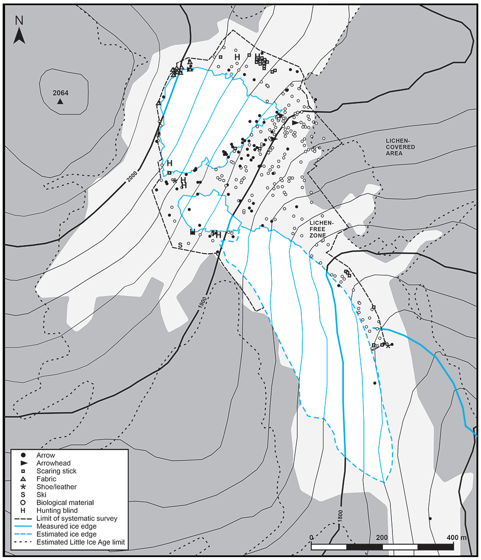
Distribution of all finds recovered at Langfonne. Measured/mapped ice margin is from August 2014, the last year of major ice retreat. Survey perimeter delineates the off-ice area that has been systematically surveyed. The extent of the LFZ is estimated from aerial photos, while the estimated ‘Little Ice Age’ maximum extent is based on Grønås (2019). Map: Lars Pilø.
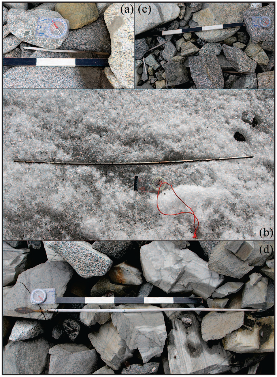
Examples of arrows found at Langfonne. (a) F62, the nock end of an arrow, radiocarbon-dated to 5910–5750 cal yr BP. Found in the scree in front of ice patch A. (b) F166, radiocarbon-dated to 3980–3830 cal yr BP. Found on the ice in the lower part of ice patch A. (c) F110, a partially preserved arrow shaft in four fragments, scattered in the scree. Radiocarbon-dated to 2310–2130 cal yr BP. Found in the scree at the upper southern edge of ice patch A. (d) F106, radiocarbon-dated to 1270-1170 cal yr BP. Found in the scree between ice patch A and B. Scale is 50 cm. Photos: Glacier Archaeology Program.
The palaeozoological material from Langfonne consists of 290 finds of animal remains (Figure 3), making up the largest collection of such material from a single ice patch site in the region (Rosvold, 2017) and probably globally as well. The palaeozoological material provides an important non-cultural control for comparison with the chronological and spatial patterns of the artefacts.
The palaeozoological material is dominated by reindeer remains (97%), of which 167 finds are antlers or cranial fragments with antlers (e.g. Figure 5, left). The rest of the reindeer material is a mix of mandibles and post-cranial bones. Males and females, adults and juveniles, are all represented. In addition, there are two rock ptarmigan (Lagopus muta) wing bones, one pelvis/synsacrum fragment of gull (likely Larus canus) and seven unidentified mammal bone fragments (likely reindeer). Only two chopped antlers show any sign of human modification. All the palaeozoological material was found lying directly on the lichen-free ground around the ice patch.
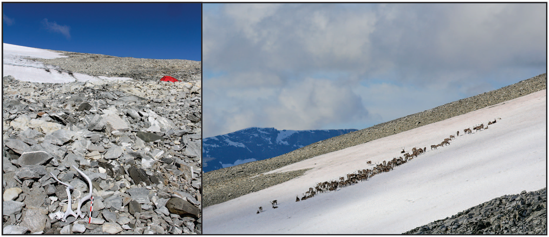
Left: Fractured reindeer cranium with large antlers. F196, radiocarbon-dated to 690-660 cal yr BP, found in the lichen-free scree below ice patch A. Photo: Glacier Archaeology Program. Right: Reindeer on the snow at Langfonne. Photo: Espen Finstad.
Chronology and spatial patterns
Seventy-one artefacts from Langfonne have been radiocarbon dated, including sixty-seven arrows, the shoe, two pieces of cut antler and a ski tip (Figure 6, Table 1 and supplemental material). The earliest traces of activity at Langfonne are found in the period c.6200–5700 cal yr BP. Langfonne is the only ice site in Norway that has produced finds earlier than c. 5500 cal yr BP. After a hiatus of around 1400 years (except for a single slate arrowhead dated typologically to 5300–4300 cal yr BP), artefacts appear again at 4350–4090 cal yr BP, peak in KDE around 4000 cal yr BP and then gradually decline to a minimum around 2000 cal yr BP. Artefacts subsequently reappear at 1720–1570 cal yr BP and continue until 750–680 cal yr BP, with a marked peak in KDE around 1200 cal yr BP. Two pieces of cut antler were recovered, which date to 1290–1190 and 1230–1070 cal yr BP. Textile and a ski tip, the latter dated to within the last c.300 years, are chronological outliers making up the most recent finds.
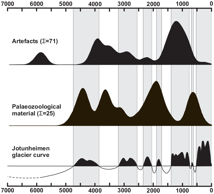
Kernel density estimation (KDE) chronological plots (see Bronk Ramsey, 2017) of naturally deposited palaeozoological material and artefacts/chopped antler. Periods with extensive glaciers in Jotunheimen in grey. Curve of Holocene glacier variations in Jotunheimen redrawn after Matthews and Herbert, 2008: Figure 8. Also see Suppl. Material no.1.
In addition to the two cut antlers noted above, 31 samples of culturally unmodified reindeer antler and bone have been dated (Table 2). Three turned out to be modern, but the other twenty-eight have been dated between c. 4850 and 350 cal yr BP. Remarkably, no unmodified palaeozoological material dates from the period c.1400–800 cal yr BP, when artefacts are most abundant (Table 1). Five pieces post-date c.800 cal yr BP, with the youngest (excluding date ranges including the present) being from 500–340 cal yr BP.
Radiocarbon dates of palaeozoological material.
The recovered artefacts from Langfonne show distinctive spatial patterning over time (Figure 7). Of the six finds from c. 6200 to 5700 cal yr BP, two were on the lower part of ice patch A, three on the ground immediately in front of the same area, and one on the ground at the lower edge of ice patch C. All these early arrows are very poorly preserved (Table 3).
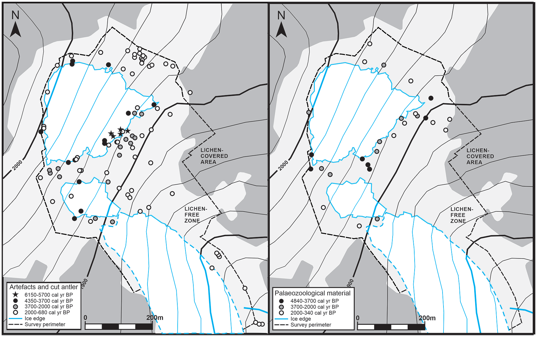
Left: Distribution map of artefacts from 6150 to 680 cal yr BP, dated by radiocarbon or typology. Arrow R2B (dated to 6180–5930 cal yr BP) is outside the map. Two of the earliest arrows are shown to be just inside the ice edge measured in August 2014 but were found on the ground in September 2014 following further ice retreat. Right: Distribution map of radiocarbon-dated palaeozoological material from 4840 to 340 cal yr BP. Maps: Lars Pilø.
Preservation of arrows. Average length is the average of the combined length of all parts of each individual arrow when several adjacent fragments were collected together.
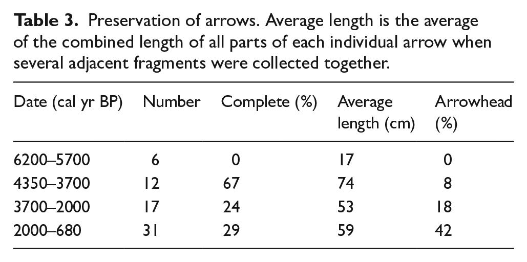
Following the artefact hiatus from 5700 to 4350 cal yr BP, there are 12 radiocarbon-dated arrows from c.4350 to 3700 cal yr BP, corresponding to the Late Neolithic in archaeological terms. The spatial distribution of these artefacts, like that of the earlier finds, closely follows the extent of the present-day perennial ice. However, the preservation of arrow shafts belonging to this period is remarkably good. Eight of twelve shafts are complete (all parts of the shaft present, whether intact or broken into fragments). This is a clear contrast with the earliest arrows, and with arrows from later periods (Table 3).
The spatial distribution of the finds is different in the subsequent period 3700 to 2000 cal yr BP (corresponding roughly to the Bronze Age and Pre-Roman Iron Age). The eighteen relevant finds were recovered further from the edge of the present-day ice than those of earlier date. The artefacts were less well preserved than those of c.4350–3700 cal yr BP, but more complete than those of 6200–5700 cal yr BP.
No recovered artefacts date between 2130 and 1720 cal yr BP. It represents another hiatus in the cultural record of the site.
Most artefacts postdating c.1720 cal yr BP are found further from the present-day ice edge than those of earlier origin. This spatial pattern begins with five arrows from c.1720–1400 cal yr BP (the Roman Iron Age and Migration Period in archaeological terms). One arrow within this date range was even found c. 100 m away from the present-day ice. Twenty-eight arrows dating between c.1400 and 680 cal yr BP (the Late Iron Age and the early part of the Medieval Period in archaeological terms) have a wide distribution. A cluster of scaring sticks, typologically dated to 1700–1000 cal yr BP, is also situated far away from the ice.
Palaeozoological material from Langfonne has been dated throughout the range 4835–1411 cal yr BP. However, the peaks in KDE of this material do not match times of relative artefact abundance. Moreover, uncut reindeer antlers and bones are absent between c.1410 and c.790 cal yr BP, when artefacts are at their most abundant. The potentially important implications of these observations will be considered in the discussion section below.
Ground penetrating radar
Ice patch A proved to have a total maximum thickness of c. 14 m. The upper 2-5 m were snow (Figure 8, above). The thickness of the ice below is estimated to be 10–12 m. The GPR data (Figure 8, below) clearly show the ice stratigraphy. The layering parallel to the surface shows new accumulation following major melt-back in recent years. Conversely, the layering of older ice at depth follows the bottom topography, which is a good indication of present or previous deformation. The extent of deformation strongly suggests a previously thicker ice patch, probably developing into a small cold based glacier during the LIA. It is also important to note that ice layers that are deep in the center of ice patch A reach a former melting surface towards its downslope edge.
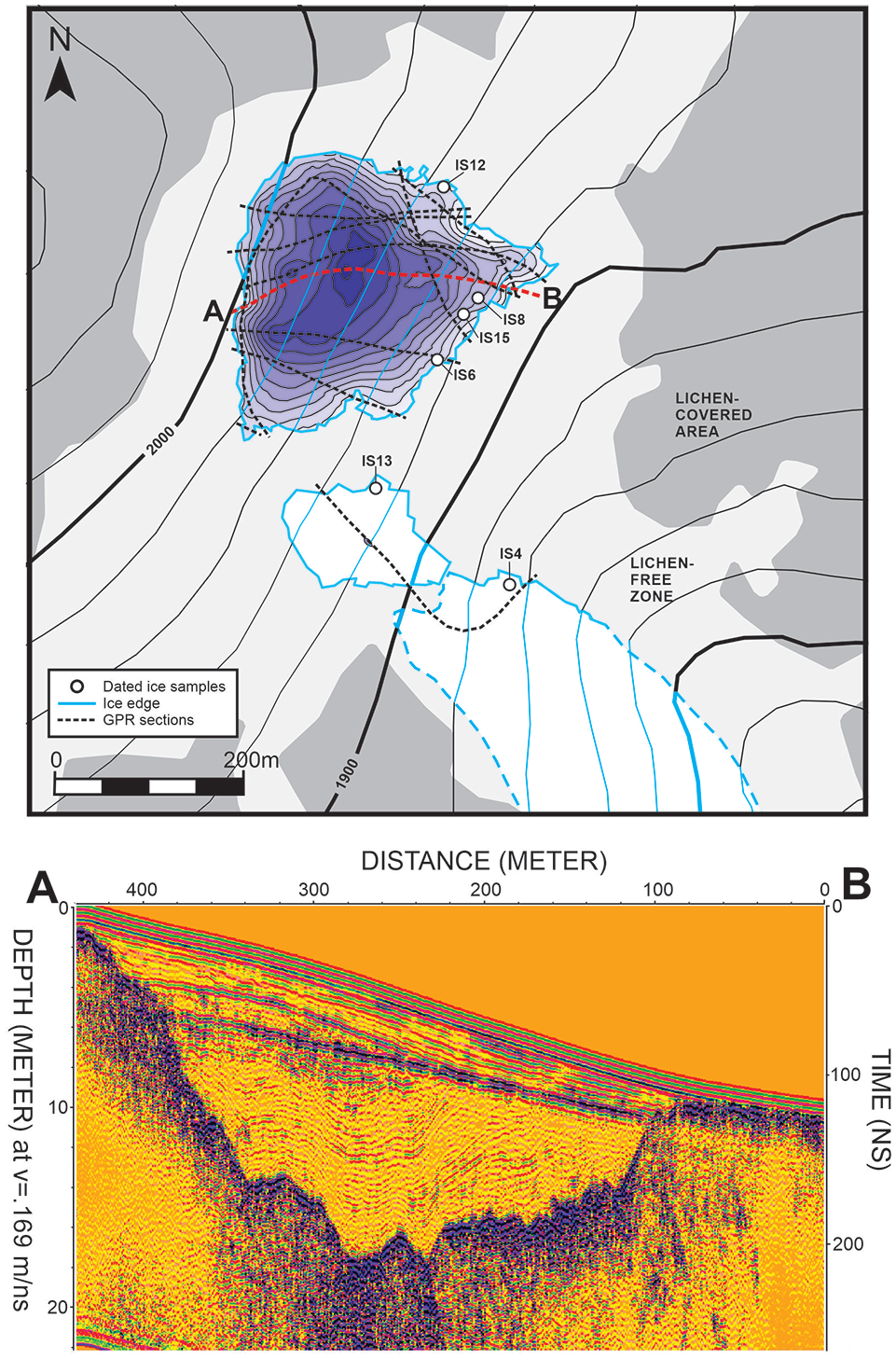
Above: Estimated thickness map of Langfonne ice patch A compiled from a GPR survey in March 2017. The edges of the ice patches were measured in August 2014 (probably late Holocene minimum thickness). The thickness map has 1 m isolines. The maximum thickness was estimated as 14 m in March 2017 (11 m in September 2014). Below: Example GPR profile. The position of the profile is shown by a red dashed line on the map. The 2014 surface is the strong reflector at 2–5 m depth. GPR-mapping: Trond Eiken and Rune S. Ødegård; adaptation (above): Lars Pilø.
Radiocarbon dating of ice layers
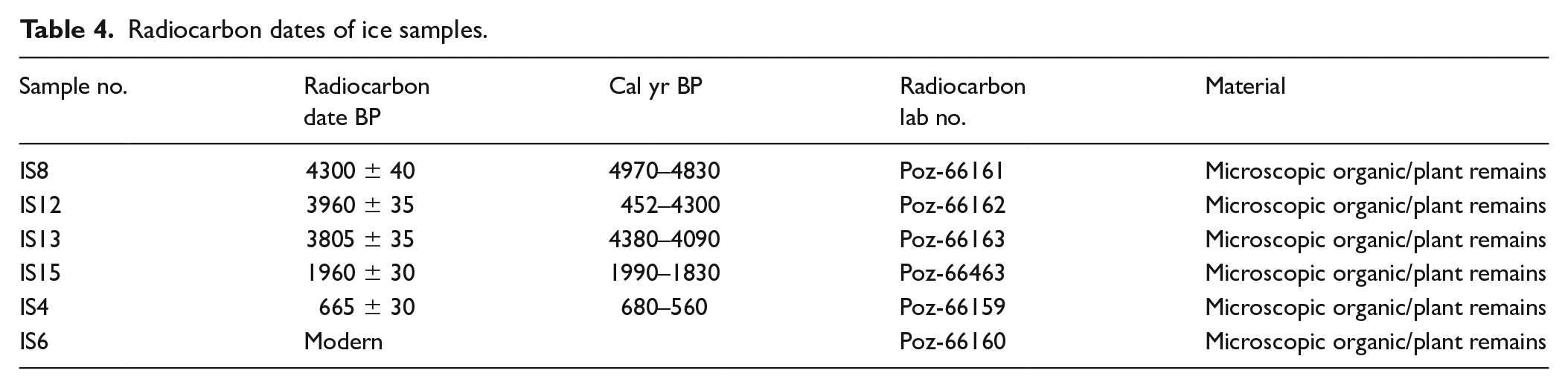
Six bulk sediment samples have been radiocarbon dated, five of which yielded pre-modern ages (Table 4, Figure 8). The dates of organic material from these concentrated melt layers provide, in each instance, an approximate terminus ante quem for the ice below the location of the sample (Jarrett, 2019). The earliest date is 4970–4830 cal yr BP (Ice patch A, IS8) while the most recent (except for a modern date) is 680–560 cal yr BP (Ice patch C, IS4). An ice sample (IS15) near IS8 gave a much younger date (1990–1830 cal yr BP), which illustrates the phenomenon of chronological mixing during melt-back of the ice. Arrows found melting out of the ice at approximately this elevation are dated to c.6000–4000 cal yr BP.
Radiocarbon dates of ice samples.
Discussion
Initial deposition of artefacts and palaeozoological material
The artefacts were likely lost during prehistoric reindeer hunting on or adjacent to the ice patch. These hunts probably took place mainly on hot days in July and August, when large numbers of reindeer congregate regularly on the ice and snow to cool and avoid botflies (Anderson and Nilssen, 1998; Ryd, 2014; Figure 5, right).
During fieldwork at Langfonne, reindeer were regular visitors to the ice on hot days. These are domesticated reindeer but behave much like wild reindeer. They entered ice patch A from the north and south. These access routes coincide with the locations of eight undated stone-built hunting blinds (Figure 3) However, the shape of the hunting blinds indicates shooting towards the ice; this suggests that the hunt took place when the reindeer were leaving rather than entering the ice patch or when the animals were resting on the ice. Reindeer currently enter ice patch C mainly from the south, en route from pastures in the Smådalen valley. There are no hunting blinds preserved along this route but shooting from the known blinds is unlikely to have been the only source of the arrows recovered at Langfonne. Sámi oral sources, referring to the 19th century, describe techniques of bow-and-arrow reindeer hunting on ice patches without the use of hunting blinds (Ryd, 2014). This involves approaching the reindeer very slowly in a hunched posture until close enough to shoot. Thus, arrows may have been lost on any part of the ice patch, the size of which fluctuated through time, and also in the surrounding scree.
A cluster of scaring sticks was found in the LFZ northeast of ice patch A (Figure 3). Scaring sticks are thought to have been set up in lines to guide reindeer during hunting. The lines would be placed according to the terrain and the wind direction (Solli, 2018). The sticks would have been placed either in the snow or in scree near the edge of the ice patch.
The palaeozoological material can be divided into three categories. First, many of the antlers of both males and females, as well as calves, have clearly been shed. These must have accumulated on the ice patch between late fall and early spring (males shed some time after the rut in late fall/early winter, while females and calves shed in the spring). These shed antlers are clearly natural background material that is not associated with hunting. Second, reindeer (and other animals) are killed or scavenged by wolverines, which establish food caches in the snow (Inman et al., 2012). Such remains are regularly found on ice patches (Rosvold, 2018) and this activity contributes to the natural background material. Third, as humans hunted reindeer on the ice patches, butchered reindeer remains should occasionally be found at Langfonne. However, only two chopped antlers show any sign of human modifications and most faunal remains seems to be naturally deposited. Wolverine caches aside, palaeozoological material was probably originally deposited randomly across the ice patch.
Displacement
The question of artefact displacement at Langfonne is complex. Finds may have been moved in situ due to ice deformation. After melting out, finds may have been moved by water, wind, permafrost processes, animals or humans. These displacements are likely to have blurred original artefact distributions and may even have created patterns that appear cultural in origin.
Recent results from glaciological investigations have revealed that the ice in large ice patches may deform due to the weight of the overlying ice and snow (Jarrett, 2019). The extent of Holocene displacement of ice at Langfonne is hard to quantify from the GPR data, but the potential ice movement can be estimated. There is no indication of temperate ice (ice which is at its melting point) at Langfonne today. The thermal conditions are probably like those of the nearby Juvfonne ice patch (Ødegård et al., 2017) and polythermal glaciers in the area (Lie et al., 2004, Reinardy et al., 2019). In the following calculations, a softness parameter of A = 2.4 × 10⁻¹⁵s-1kPa-3 is used assuming an ice temperature of –2°C from Table 5.2 in Paterson (1994). The average thickness of the deepest parts of Langfonne during recent decades is c. 20 m. This estimate is based on mass balance measurements at Juvfonne, where the melt anomaly in the period 2009-2014 caused a loss of 10 m of ice (Ødegård et al., 2017).
Given a thickness of 20 m, the estimated maximum basal shear stress is c. 60 kPa (surface slope 19°, laminar flow). Calculations of deformation based on Glen-type flow depends strongly on the chosen stress component (Glen, 1955). Using a stress component of n = 2 (Duval et al., 2000) gives a surface velocity of 3.3 m 1000 years-1 (surface slope 19°, laminar flow, thickness 20 m) or 0.0033 m per year. A similar calculation for an estimated ‘Little Ice Age’ thickness of 30 m gives a surface velocity of 11 m 1000 years-1 or 0.011 m per year.
These calculations are estimates but indicate that cumulative deformation of ice over millennia can explain the observed layering, and hence control the maximum age of artefacts embedded in the ice patch and exposed at its surface. In particular, the GPR profile in Figure 8 shows clear ice stratification of isochronic origin. Layers that were exposed close to the downslope margin of the 2014 surface (seen as the boundary between deformed ice and layers parallel with the surface) can be observed at greater depth in upper parts of the ice patch. If this interpretation is correct, the oldest ice will have been exposed close to the downslope front of ice patch A in years when the deformation structures were exposed following summer melting.
Within the ice patch, there has also been vertical displacement (from higher to lower levels) of artefacts during melting events. This process creates the chronologically mixed dark accumulation horizons in the ice. Given the relatively steep slope of Langfonne (and most ice patches), this stratigraphic movement of artefacts will normally also be accompanied by varying degrees of horizontal displacement. That most artefacts are recovered from the ground, not on the ice, is mainly due to a combination of vertical and horizontal displacement because of melting and freezing. Most of these artefacts were probably lost on the snow originally.
On a day of heavy melting in September 2014, one of our team members witnessed downslope displacement of an arrow shaft by meltwater in the lower part of ice patch A. This process has clearly been a regular occurrence, explaining the accumulation of finds in front of the ice. This pattern is also common at other ice patch sites. Unless otherwise moved, the distribution of such artefacts indicates the ice edge at the time of melting. It does not represent where the finds were originally lost.
Arrowheads of stone and iron are of greater mass than the wooden shafts, and not as prone to downslope movement. They can melt into the ice when heated by the sun. Shafts and arrowheads become separated, with shafts alone being transported to the downslope edge of the ice patch. Isolated arrowheads are difficult to see during survey. Only five have been recovered from Langfonne (Figure 3).
When Langfonne was much larger than today (e.g. during the ‘Little Ice Age’) the surface slope of the ice patch may have been less steep, reducing horizontal displacement. Moreover, some artefacts found near the downslope margin of the ice may actually be in situ, having been lost in scree below the ice. Others may have ended up there due to ice deformation as discussed above, or a combination of processes. Individual finds will thus have distinct taphonomic histories, but in general artefacts cluster at the lower edge of an ice patch like Langfonne because of melting and gravity. Conversely, finds recovered from the lichen-free ground along the upper edge of the ice are unlikely to have been displaced in the same way (see also Farbregd, 1972: 10). Otherwise, they would be found elsewhere.
Finds from the sides of ice patches would often have had shorter paths from melting out to deposition at the ice edge. Thus, downslope displacement is likely to be less pronounced. Few finds will have been displaced across the slope, but this is possible given strong winds.
Farbregd (1972) pointed to the role of meltwater displacement of arrows. He noted that few of the arrows found in front of the ice patches at Oppdal (c. 150 km NE of Langfonne) retained their arrowheads and suggested that this was a result of differential downslope transport. Langfonne, which provides a large georeferenced artefact sample from a single site, shows this pattern clearly (Figure 9, left). Only one of the arrow shafts found in front of ice patch A has an associated arrowhead, whereas approximately half of the arrow shafts on the top and sides of the patches do so. Ice patch B has four of six arrow shafts in front of the ice without arrowheads, while ice patch C has four out of five arrow shafts without arrowheads.
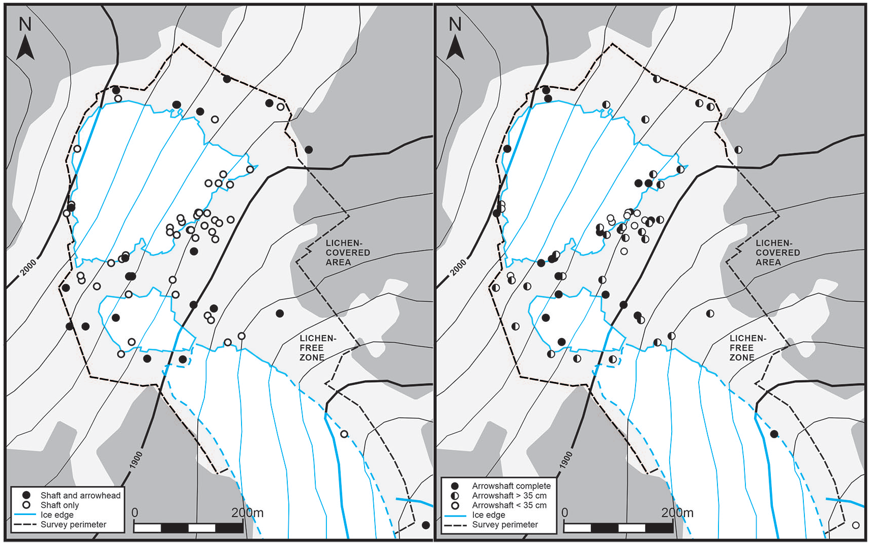
Left: Distribution map showing that most of the arrow shafts below the ice patches have lost their arrowheads, in contrast with about half of the arrows lying elsewhere. Right: Distribution map showing that arrow shafts preserved as lengths under 35 cm were concentrated below ice patch A. The association of state of preservation with distance from the ice is otherwise weak. Map: Lars Pilø.
Some downslope movement may also occur due to rock falls. However, active scree movement is probably most relevant to the preservation of finds once they have melted out.
Finds of low mass and high surface area may have been displaced by wind, as is evident from the spread of textile fragments belonging to an at most 200-year-old object at the upper edge of ice patch A, which was probably originally preserved within the ice (Pilø, 2020). Given their shape, it is unlikely that arrows, the shafts of scaring sticks, antlers and bones lying in the scree were significantly moved in this way. Conversely, fabric and the thin wooden flags from scaring sticks could be easily caught by the wind. In areas without scree, such as exposed bedrock or the ice surface, some objects may have been subjected to wind displacement regardless of shape.
Finds may also be displaced or even removed by human visitors, a process that is well known from other ice sites in Innlandet County. This may affect individual finds but should not introduce systematic bias to the record.
Overall, finds along the upper edges of the ice patch are probably more or less in their original position, except that they have melted to the ground. The main examples at Langfonne are arrows. Finds along the sides of the ice patch, such as the cluster of scaring sticks northeast of Ice patch A (Figure 7), may approximately reflect their original position, with limited horizontal displacement. This group of artefacts may be the remains of a guide-line that prevented deer from leaving the ice patch in this direction. Most finds at the lower edge of the ice patch, conversely, have been displaced downslope and do not represent where the objects were initially deposited. This downslope movement will have occurred within the ice to a limited degree, but mostly through the action of meltwater once objects were exposed on the surface. The location of these downslope finds is thus a reflection of the size of the ice patch when the relevant artefacts melted out, prior to the impact of differential preservation.
Preservation
In addition to displacement, there is also the question of how the preservation of artefacts may influence chronological and spatial patterning. Do taphonomic processes lead to finds of certain raw materials or from certain time periods being differentially preserved?
It is self-evident that finds lost in snow during periods of ice retreat would be likely to melt out again, possibly repeatedly with the seasons, decreasing their chances of long-term preservation. Conversely, if snow containing lost artefacts or the osseous remains of animals such as reindeer does not melt in the following summers it will compress and move downslope as it transforms to ice (Kawasaki et al., 1993). This process could lead to the breaking of some finds (the long thin shafts of arrows for example), but during periods of ice expansion it would in general lead to better chances of long-term survival; a higher percentage of the lost objects would be preserved (see Nesje et al., 2011).
Nevertheless, ice deformation (as indicated in ice patch A, e.g.) could potentially influence the preservation of artefacts even if rapidly incorporated. In this context, it is worth noting the poor state of preservation of two very early arrows (c.6000–5750 cal yr BP) recovered on the ice surface near the downslope margin of ice patch A. GPR evidence shows that old ice layers reached the melting surface here, and one radiocarbon date on a horizon of organic material (IS8) suggests that these arrows melted from ice of considerable age. They are thus likely to have been less exposed to the elements than other arrows found off the ice. Lengthy encapsulation in old ice should theoretically have left them well preserved, but this was not the case. They were broken into short fragments. The same applies to arrows of similarly old date found just in front of ice patch A, having been water transported prior to their recovery. Four out of five arrow shafts dating between c.6150 and 5700 cal yr BP found on or in front of ice patch A consisted of only a single short fragment (<=23 cm), with no preserved tar, sinew or fletching. Another arrow shaft of this date range, also highly fragmented (being 10 cm in length), was found below ice patch C. Four other very fragmented arrow shafts (<35 cm in total length) were also found below ice patch A (Figure 4a). This high fragmentation of old artefacts that have only recently melted out may be linked to ice deformation rather than exposure to the elements. An alternative explanation is that these nine highly fragmented arrows had previously melted out in the distant past (suffering fragmentation and decay on exposure) before being incorporated into re-expanding ice, and finally melting out again shortly before the archaeological survey.
The decay of artefacts that have melted out of the ice patch will be influenced by meltwater, length of exposure, freeze/thaw cycles, the weight of seasonal snow and ice, moisture, trampling, scree movement, and temperature (of air and soil) among other factors. When arrows melt out, water with suspended sediment runs over them. This has an abrasive effect, removing tar and sinew from the wooden shafts. The process can be observed in the field. Once out of perennial ice, and lying directly on uneven scree, finds such as arrows would also have been repeatedly overlain with heavy seasonal snow and ice and subjected to the stresses of freeze/thaw cycles. In many cases this leads to breakage. The scree on which most of the finds rest is also an active paraglacial environment. The steeper the terrain, the more active the scree. The stones in the scree move due to meltwater, freezing, and/or downslope movement. This leads to finds being displaced and/or damaged (or buried and never found). Even large antlers from Langfonne often show breakage, caused within perennial ice, after melting out, or both (Rosvold, 2018). Fragmentation can also occur due to trampling, by herds of reindeer for example.
Observations at Langfonne and other ice patch sites in the region (e.g. Lendbreen and Juvfonne) show that wood, birch bark, bone and antler can nevertheless survive for a long time outside the perennial ice (Ødegård et al., 2017; Pilø et al., 2020). How long has yet to be established empirically, but at least decades and possibly much longer. Sometimes these materials are preserved even at sites where the ice has mostly or completely melted. Arrows exposed for a long time have usually lost all sinew, tar and fletching, but nevertheless remain as recognisable shaft fragments, sometimes naturally freeze dried. This material is ideal for radiocarbon dating and the study of chronological and spatial patterns. It is notable that the oldest radiocarbon dates from Langfonne come from arrows rather than reindeer bone or antler. In the atypical environment of the high mountains, the preferential preservation of osseous materials over wood (characteristic of most archaeological contexts that are not waterlogged or desiccated) cannot be assumed. However, the absence of dated palaeozoological material from c. 6200 to 5700 cal yr BP may also be partly a product of the subsampling strategy. Only a selection of the collected bones and antlers was dated, with a preference for specimens that were well preserved and could be unambiguously identified to species. Poorly preserved bones and antlers, potentially contemporary with the earliest arrows, may not have been selected for dating.
The micro-conditions of find locations influence preservation. The deeper into the scree an artefact is situated, the better it is likely to be preserved. Favourable local conditions for snow catchment, such as large boulders or depressions in the terrain, can lead to local snowdrifts, which also enhance preservation (e.g. the Iron Age tunic found in a small depression at Lendbreen (Vedeler and Jørgensen, 2013)). This may explain why the preservation status of individual finds is very weakly associated with distance from the surviving ice patch at Langfonne (Figure 9). Complete arrows were mostly found near the surviving ice, but large pieces (>35 cm in surviving length) were recovered even at the edge of the LFZ; arrow shafts retaining their arrowheads were found both adjacent to and distant from the ice edge at the time of survey.
Conversely, the age of artefacts is clearly associated with distance from the ice (Figure 7). This observation may imply a long-term taphonomic overprint, irrespective of micro-conditions and the potential for wood to survive after it has melted out. Fewer old finds may survive in the zone of past ice patch expansion and contraction, the present LFZ. All artefacts dating between c. 6200 and 3700 cal yr BP were recovered on or immediately adjacent to the surviving ice whereas those dated 3700 to 2000 cal yr BP were recovered both at and a short distance from the surviving ice edge. Artefacts post-dating 2000 cal yr BP have been found throughout the LFZ.
This spatial patterning by date raises the possibility that the overall chronological distribution of artefacts will also have age-related bias, the classic taphonomic challenge of archaeology (Surovell et al., 2009). At Langfonne, this potential association can be independently evaluated by comparing the differing preservation of arrows through time, and by comparing the radiocarbon dates of the artefacts (mostly wooded arrows) and the palaeozoological material (samples of reindeer antler and bone).
Firstly, as noted above, although the oldest arrows dating c.6200 to 5700 cal yr BP are worst preserved, those dating between 4350 and 3700 cal yr BP are more complete than arrows of more recent date (Table 3). Thus, the circumstances and location of initial deposition may be more important determinants of preservation than absolute age. Secondly, there is no association between the survival of cultural and palaeozoological material, as would be expected if varying preservation was the main determinant of chronological patterning (Figure 6). A similar situation was found at Lendbreen (Pilø et al., 2020). The fluctuating abundance of artefacts (mainly arrows) may thus retain a signal associated with the intensity of hunting, despite the noise of varying preservation conditions as the ice patch grew and shrank through time.
It is particularly striking that the only reindeer finds dating from the most arrow-rich time period, from c.1410 to c.790 cal yr BP, are two antlers with cut marks. Natural reindeer remains were present at Langfonne both earlier and later, when artefacts were rare or absent and hunting was probably at a minimum. Between c.1410 to c.790 cal yr BP, however, it would seem that most (shed and unshed) antlers, and perhaps also complete reindeer carcases, were actually removed from the site – an indirect corroboration of intense human activity, which peaked at c.1200 cal yr BP, just before the Viking Age. Reindeer were valued for both their meat and their antlers, the latter serving as raw material for craftworking (Ashby et al., 2015; Hufthammer et al., 2011; Pilø et al., 2018; Rosvold et al., 2019). Alternatively, it is possible that intense hunting pressure may have disturbed the reindeer herds to a degree that they would have spent less time at Langfonne.
The high number of finds from the Late Iron Age and the early part of the Medieval Period is a general pattern in the region (Pilø et al., 2018). It also coincides with a dramatic decrease in reindeer population numbers around 950–750 cal yr BP, shown in a genetic study (Røed et al., 2014). The weight of the evidence indicates that the high number of lost arrows at Langfonne during this period is at least in part related to more intensive hunting.
Notably, an earlier peak in artefact abundance c.4350–3700 cal yr BP also coincides with reduced reindeer finds (Figure 6), despite an abundance of antlers or bones before and after. The negative association between evidence of hunting and the presence of reindeer remains may be a recurring pattern, indicative of human intervention. This earlier peak occurs at the transition from the Neolithic to the Bronze Age.
Chronology and size of the ice patch
Based on data from Juvfonne (23 km west-southwest of Langfonne), it is possible that Langfonne had developed as an ice patch by c.7600 cal yr BP (Ødegård et al., 2017). The earliest Langfonne arrows imply that an ice patch existed by c.6200–5700 cal yr BP, and earlier finds may still be inside the oldest ice that has not yet melted out. Little can be inferred about the size of the ice patch at this date, because the artefacts were found near the downslope edge of ice patch A and were potentially displaced by meltwater and gravity. Nevertheless, it is likely that Langfonne fluctuated in size during the early millennia of its existence, when climate change was influencing the development of glaciers in Jotunheimen (Matthews and Dresser, 2008).
There is a hiatus in artefacts between 5700–4350 cal yr BP, but three finds of palaeozoological material do date from 4840 to 4420 cal yr BP and the earliest date on organic material from dark layers in the Langfonne ice is 4970–4830 cal yr BP (sample IS8). Moreover, an arrow from the Storfonne ice patch (2 km east of Langfonne) dates to the Langfonne artefact hiatus and, in a wider perspective, several artefacts dating to the Langfonne hiatus have also been found in the Oppdal ice patch material 80 km to the northeast (Åstveit, 2007; Callanan, 2013). All of this evidence suggests that an ice patch would have existed at Langfonne during the gap in artefact finds. In fact, glacial ice in Jotunheimen expanded during this period (Matthews and Dresser, 2008; Velle et al., 2010).
One scenario in which arrows could have disappeared so completely is if the size of the ice patch was considerably larger than in the preceding and following periods. The expansion and following melt back would have left the arrows stranded far away from the ice during an extended period, and thus lost. As this interpretation is hypothetical, the reason for the artefact hiatus from 5700-4350 cal yr BP is at present unsolved, but it is unlikely to have resulted from an absence of ice at Langfonne.
The well-preserved arrows from c.4350 to 3700 cal yr BP also coincide with a period of large glaciers in the Jotunheimen region (Matthews and Dresser, 2008). Ice conditions could thus explain their good preservation, but the locations of these arrows (close to the existing ice edge) do not suggest a major increase in the size of the ice patch at this date (Figure 7).
In contrast, arrows dating between c. 3700 and 2000 cal yr BP were found further out from the surviving ice, below and along the sides of patch A in particular (Figure 7). This pattern may indicate that the size of ice patch A was sometimes larger during this period than previously. If so, the poorer state of preservation of these arrows may be due to repeated exposure during fluctuations in the extent of ice cover. The glaciological record from Jotunheimen shows both glacier advances and retreats taking place over the relevant centuries (Matthews and Dresser, 2008). The poorer preservation of artefacts from 3700 to 2000 BP at Langfonne could thus reflect exposure of the material on several occasions, despite episodes of ice patch growth.
The subsequent artefact gap between 2130 and 1720 cal yr BP, during which palaeozoological material is abundant, coincides with a short but marked glacier retreat in Jotunheimen (Matthews and Dresser, 2008). The hiatus might thus reflect a reduction in the size of Langfonne, leading to poor preservation and/or altered conditions that led hunters to seek their prey elsewhere. An arrow from Handklefonne (800 m north of Langfonne) is radiocarbon-dated to 1950-1740 cal yr BP and an arrow from nearby Storfonne is radiocarbon-dated to 1930-1730 cal yr BP. Thus, hunting was on-going at Kvitingskjølen at this time, even if there is no evidence of it at Langfonne.
When arrows appeared again from c. 1720 cal yr BP onwards, it was at first during a period of glacier retreat in Jotunheimen that lasted until c.1350 cal yr BP (Matthews and Dresser, 2008), despite the fact that preservation potential should have been low. Within the resolution of radiocarbon dating (see Pilø et al., 2018), the number of dated arrows then increased further during a period of large glaciers in Jotunheimen (Matthews and Dresser, 2008). Arrows peaked in abundance around 1200 cal yr BP, before disappearing again by c.680 cal yr BP (Figure 6). Overall, the arrows and other hunting-related artefacts (e.g. the cluster of scaring sticks northeast of ice patch A) dating to the period 1720 to 680 cal yr BP show a wide distribution beyond the edge of the present day ice, suggesting that Langfonne was often larger than it had been before c.2000 cal yr BP (Figure 7).
It is unlikely that finds are missing from 680 to 270 cal yr BP due to poor preservation; Langfonne was large during the ‘Little Ice Age’. The explanation for the lack of finds of this date range is probably limited hunting activity. The paucity of finds matches well with wider evidence from the region that reindeer hunting and trapping reached a climax before 700 years ago, being much reduced in the following centuries (Pilø et al., 2018; Solli, 2018).
Conclusion
This paper has asked whether, after taking archaeological site formation processes and taphonomy into account, find distributions can yield information regarding the organisation and chronology of human activity at Langfonne, and the changing size of the ice patch through time? Impacts of site transformations are clearly evident but may not obliterate all underlying spatial and chronological patterning.
Archaeological site formation processes displaced artefacts deposited at Langfonne. In particular, ice deformation and downslope movement, exacerbated by the flow of water, means that many objects were deposited along the lower edge of the ice patch as its melted. The locations of most artefacts will not indicate spatial patterns of human activity at Langfonne and comparable sites. The main exceptions are finds deposited at the upper edge and along the sides of ice patches, which may melt out with less displacement from their original locations. At Langfonne, it is therefore possible to observe that (on one or more occasions between 1700 and 1000 cal yr BP) a cluster of scaring sticks may have been placed to divert reindeer from exiting ice path A along its north-eastern margin.
The displacement of artefacts also adds uncertainty to any effort to estimate the past size of an ice patch from distributions of artefacts of differing dates. Nevertheless, it is likely that Langfonne was at least periodically larger than at present during the last 3700 years. Most artefacts dating between 3700 and 680 cal yr BP were found at some distance from the edge of the melting ice at the time of fieldwork in 2014 and 2016.
The association between artefact age and state of preservation was surprisingly very weak. The oldest artefacts were the worst preserved, but arrows from c.4350 to 3700 cal yr BP were among the most complete of any date. The spatial distribution of arrows in differing states also showed that preservation status was not directly correlated with distance from the present ice edge. This counter-intuitive outcome results from the influence of micro-conditions (e.g. depressions within the scree) and from the unusual environment of this high elevation environment (which is especially conducive to the survival of wood and birch bark).
The weak impact of age-related taphonomy is corroborated by the lack of association between the chronology of artefacts and of reindeer antlers and bones. If peaks and troughs in find abundance were determined mainly by preservation conditions the two groups of materials should show similar chronological patterning. This was not the case. Periods of maximum arrow abundance were times with very few reindeer finds. In fact, the period of maximum arrow finds, between c.1410 to c.790 cal yr BP, yielded only two antlers, both of which had cut marks from harvesting by humans. It would seem not only that peaks in arrow finds may preserve evidence of increased hunting, but also that reindeer products (shed antlers and whole carcases) were systematically removed from the ice patch at the same time.
In summary, as in all archaeological contexts, site formation processes and taphonomy need to be taken into consideration before interpreting the spatial and chronological patterning of finds at ice patches. The character and impact of these processes is distinctive and sometimes (e.g. downslope movement) severe. With qualifications, inferences regarding on-site human activity and fluctuations in ice patch size may nevertheless sometimes be justified.
By implication, careful study of the spatial and chronological patterning of artefacts from ice patches may yield information of considerable value to archaeology. For example, knowing that an apparent peak in high-elevation hunting at c.1200 cal yr BP is unlikely to be a taphonomic bias highlights the importance of glacial archaeology to our understanding of expanding resource extraction within Norway immediately prior to the start of the Viking Age, a period of enhanced trade and centralising political organisation (Pilø et al., 2018; 2020). Moreover, that another peak in hunting apparently occurred at c.4350–3700 cal yr BP, during the transition from the Neolithic to the Bronze Age, merits further archaeological consideration. With due attention to archaeological site formation and taphonomic processes, glacial archaeology has the potential to transform our understanding of past high-elevation activities and their wider significance.
Supplemental Material
sj-jpg-1-hol-10.1177_0959683620972775 – Supplemental material for Interpreting archaeological site-formation processes at a mountain ice patch: A case study from Langfonne, Norway
Supplemental material, sj-jpg-1-hol-10.1177_0959683620972775 for Interpreting archaeological site-formation processes at a mountain ice patch: A case study from Langfonne, Norway by Lars Holger Pilø, James H Barrett, Trond Eiken, Espen Finstad, Sunniva Grønning, Julian R Post-Melbye, Atle Nesje, Jørgen Rosvold, Brit Solli and Rune S Ødegård in The Holocene
Footnotes
Acknowledgements
The Glacier Archaeology Program in Innlandet County is a cooperation between Innlandet County Council and The Museum of Cultural History at the University of Oslo. Our heartfelt thanks go to Reidar Marstein for discovering and reporting the site, and for his invaluable assistance during our fieldwork at Langfonne. Thanks to the many archaeologists who have participated in the fieldwork.
Funding
The author(s) disclosed receipt of the following financial support for the research, authorship, and/or publication of this article: The Glacier Archaeology Program in Innlandet is funded by the Ministry of Climate and Environment, the Directorate for Cultural Heritage, Innlandet County Council and the Museum of Cultural History. James H. Barrett’s participation was also supported by the Leverhulme Trust project Northern Journeys (MRH-2013-065). The Glacier Archaeology Program in Innlandet can be followed at ![]()
Supplemental material
Supplemental material for this article is available online.
References
Supplementary Material
Please find the following supplemental material available below.
For Open Access articles published under a Creative Commons License, all supplemental material carries the same license as the article it is associated with.
For non-Open Access articles published, all supplemental material carries a non-exclusive license, and permission requests for re-use of supplemental material or any part of supplemental material shall be sent directly to the copyright owner as specified in the copyright notice associated with the article.