
Abstract
Tephra layers can form useful age-equivalent stratigraphic markers for correlating palaeoenvironmental sequences and they provide information about the spatio-temporal nature of past volcanic ash fall events. The use of microscopic ‘cryptotephra’ layers has both increased the stratigraphic resolution of tephra sequences in proximal areas and extended the distal application of tephrochronology to regions of the world situated far from volcanoes. Effective tephrochronology requires the discrimination between in situ tephra deposited directly from volcanic plumes and tephras that have been remobilised since their initial deposition. We present tephrostratigraphic and glass chemistry data from two proximal peat profiles (one lowland, one upland) from the Shetland Islands, UK. Both profiles contain the Hekla-Selsund tephra (deposited c. 1800–1750 cal.
Introduction
Tephra layers can form stratigraphically distinctive and spatially extensive isochronous horizons, and offer outstanding potential for the dating and correlation of sedimentary sequences and palaeoclimatic records (a technique referred to as tephrochronology, e.g. Lowe, 2011; Thórarinsson, 1944). Depending on location, the weather at the time of the eruption, the explosivity and volume of ejecta produced, tephras can form extensive layers visible in the stratigraphy (e.g. Larsen et al., 1999; Lowe et al., 2000). In addition, a combination of low deposition volume and very small grain sizes can lead to the formation of tephra deposits that are hidden from view (e.g. Dugmore, 1989; Dugmore et al., 1995; Gehrels et al., 2006; Hall and Pilcher, 2002; Hang et al., 2006; Payne et al., 2008; Wastegård, 2005). These ‘cryptotephras’ (sensu Lowe and Hunt, 2001) are important for two reasons. They can be used to increase the numbers of discrete tephra horizons in proximal areas of fallout – adding details to the stratigraphy between the visible layers of tephra, and can also be identified across continental scales, greatly increasing the potential applications of the technique and creating opportunities for correlations of fundamental importance, such as those between ice core, marine and terrestrial proxy records.
Tephras are also important for understanding the spatio-temporal nature of volcanic ash hazards. For example, Swindles et al. (2011) and Lawson et al. (2012) carried out comprehensive spatio-temporal analysis of European cryptotephras in peats and lake sediments and provide a probability estimate of how frequently volcanic ash clouds affected northern Europe during the Holocene. One prerequisite for studies using tephra layers for volcanic hazard research, or for dating and correlating sedimentary sequences, is that the primary air-fall deposit is identified through appropriate stratigraphic, petrographic and geochemical methods (Dugmore and Newton, 2012; Swindles et al., 2010; Westgate and Gordon, 1981). However, several studies have suggested that tephra records can be confounded by taphonomic problems including the re-working of primary air-fall deposits (Boygle, 1999; Dugmore et al., 1995; Edwards and Craigie, 1998; Gudmundsdóttir et al., 2011; Payne and Gehrels, 2010). In this paper we present unambiguous evidence of redeposited cryptotephra layers in Holocene peats from the Shetland Islands, UK (Figure 1) that are a result of the re-working of primary ash-fall deposits. We use pollen analysis to provide landscape context and to examine the factors leading to the re-working of tephras.
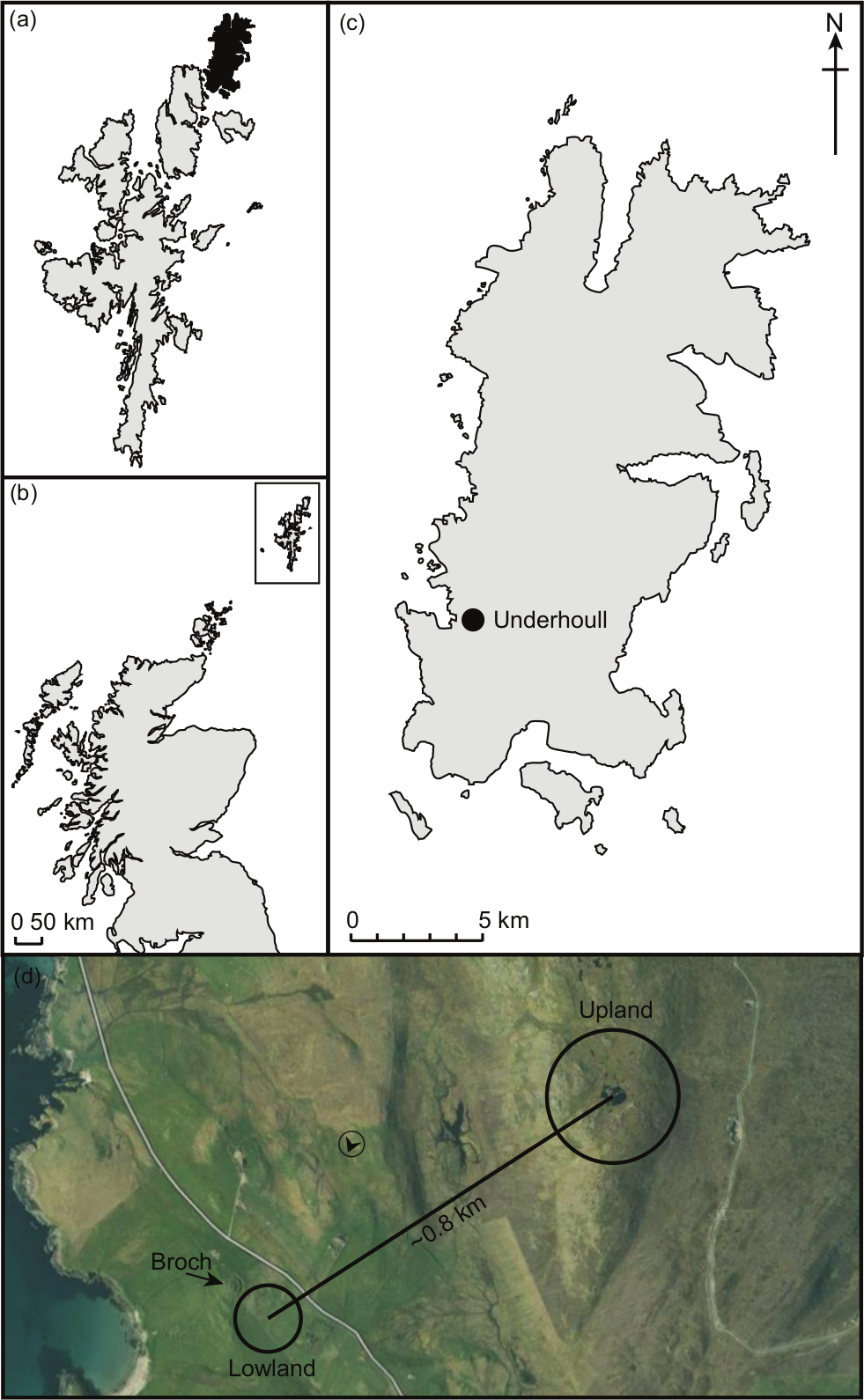
The study location. (a) The island of Unst (shaded black) within the Shetland Islands; (b) the position of Shetland relative to the UK mainland; (c) Underhoull in Unst; (d) relative locations of the upland and lowland sampling sites. The Broch of Underhoull is highlighted and the viewing position from which photo (b) (Figure 2) was taken is shown (the arrow within a circle).
Methods
An 80 cm peat sequence from Underhoull in Unst, Shetland Islands, (Figure 1) was sampled in 2008 (the ‘lowland site’). A monolith tin was used to extract a column of peat from the open face of a trench (following de Vleeschouwer et al., 2010). This peat formed in a small (~13 m × 8 m) topographic hollow adjacent to a Norse longhouse, referred to as the ‘Upper House’ (Bond et al., 2013) to distinguish it from the ‘Lower House’ investigated downslope by Small (1966). The site is immediately south of the Iron Age ‘Broch of Underhoull’ (DD: 60.71878, −0.9475). A 160 cm core was extracted from an upland peat bog (the ‘upland site’) using a Russian corer and the parallel hole method (following de Vleeschouwer et al., 2010). The upland site is at the crest of a hill directly to the northeast of the Norse longhouse and thus the two sites are only separated by a distance of ~820 m (DD: 60.7225, −0.9344) (Figures 1 and 2).
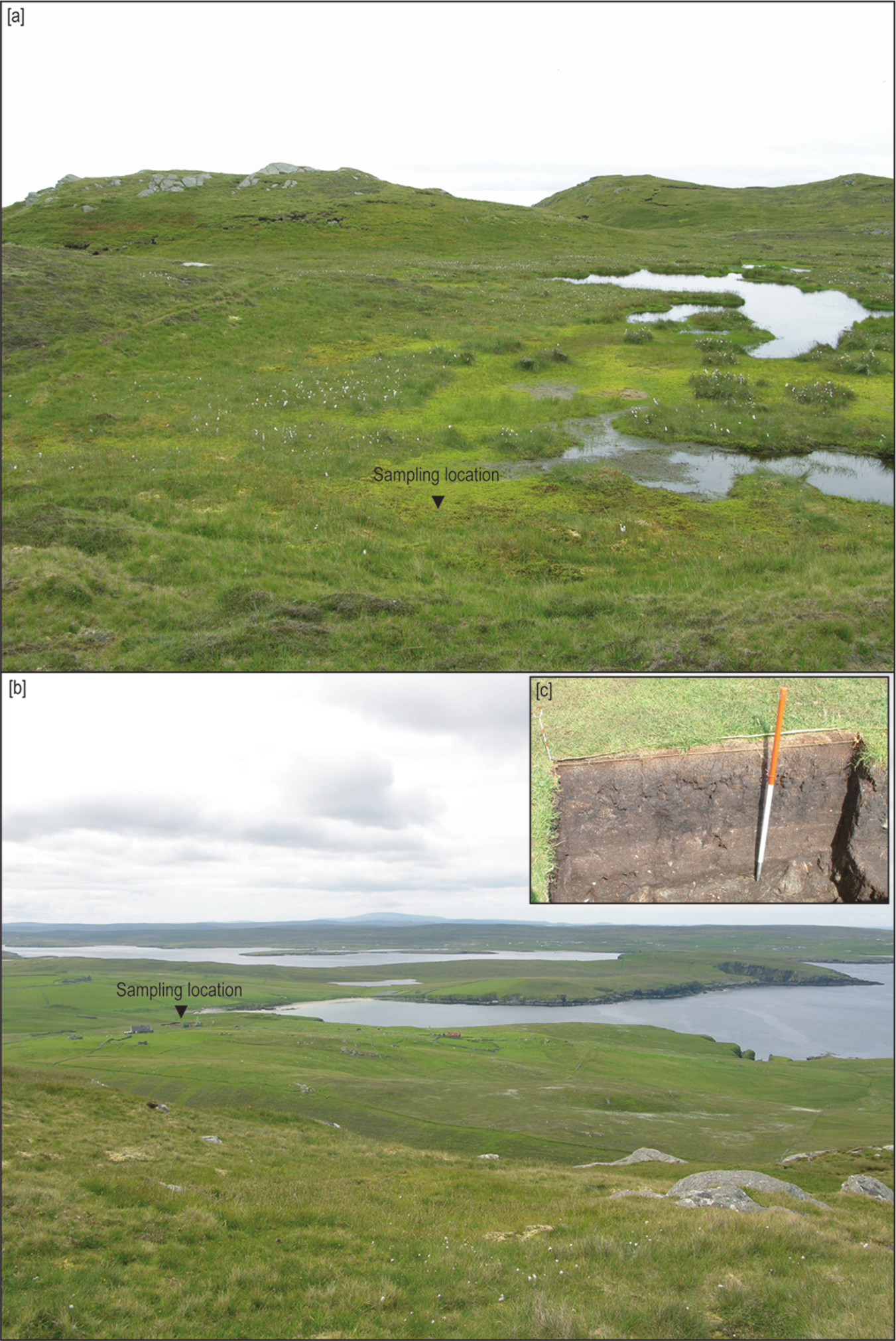
Photographs of (a) the coring location in the upland peatland at Underhoull; (b) the lowland site at Underhoull (also see Figure 1); (c) the peat section at the lowland site.
All the peat samples were stored at 4°C prior to subsampling. Tephra layers in each profile were determined using an ashing and extraction technique on contiguous 1 cm samples (Hall and Pilcher, 2002; Swindles et al., 2010). Loss-on-ignition was carried out using standard methods (Dean, 1974). As the samples contained some minerogenic material, LST Fastfloat (2.3–2.5 g/cm3) was used to concentrate the shards. The total number of tephra shards within a 1 cm3 sample was counted under light microscopy at 100–200× magnification. Peat samples from depths of peak shard concentration were selected for subsequent geochemical analysis (Payne and Gehrels, 2010). Approximately 5 cm3 of peat was acid-digested (using H2SO4 and HNO3) following standard procedures (Pilcher and Hall, 1992) and density separation was undertaken as before. The samples were sieved through a 10 µm mesh and washed with deionised water before being centrifuged to concentrate the tephra shards. The tephras were mounted on glass slides and epoxy disks and were polished to a 0.25 µm diamond finish before being carbon coated (e.g. Hall and Pilcher, 2002; Swindles et al., 2010).
The majority of the geochemical analysis was carried out at the UK Natural Environment Research Council (NERC) Tephra Analytical Unit at Edinburgh University. A CAMECA SX100 electron microprobe with an accelerating voltage of 15 kV, a beam current of 2 nA and diameter of 5 µm was used for the wavelength-dispersive spectroscopy (WDS) analyses. The microprobe was calibrated using a mixture of natural and synthetic standards and instrument stability was monitored using both a Lipari obsidian and BCRsg glass standard. X-PHI corrections for counter deadtime, atomic number effects, fluorescence and absorption were undertaken on the instrument’s PeakSight version 4.0 software. Energy-dispersive spectroscopy (EDS) using the Princeton Gamma Tech Spirit EDS system was used to aid in the initial detection of tephra shards. Once a shard was located, the beam was moved to a flat section of the shard (avoiding vesicles) for wavelength-dispersive spectroscopy. Further analyses were carried out on the University of Leeds Jeol 8230 electron microprobe. Comparison of tephra and standard analyses showed the results to be equivalent. It has been suggested that acid digestion can alter the chemistry of tephra shards (Blockley et al., 2005; cf. Dugmore et al., 1992). However, the use of the acid digestion method allows us to carry out ‘like-with-like’ comparisons with type data which have been prepared in this way. Our results were compared with those on Tephrabase (Newton et al., 2007).
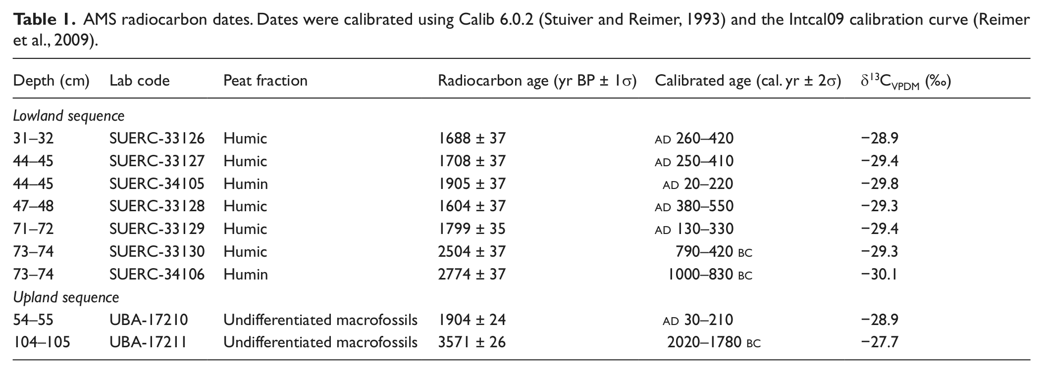
Samples were submitted for AMS 14C dating at the NERC radiocarbon laboratory at East Kilbride, Scotland. In the upland sequence, macrofossils (>125 µm) were sieved from the peat and dated. At the lowland site the peat did not contain easily identifiable macrofossils so measurements were carried out on a combination of the humin and humic acid fractions. Dates were calibrated using Calib 6.0.2 (Stuiver and Reimer, 1993) and the Intcal09 calibration curve (Reimer et al., 2009).
Samples from the upland site were prepared for palynological analysis following the standard techniques described by Fægri et al. (1989) excluding hydrofluoric acid (HF) treatment. Pollen samples from the lowland site were treated with HF because of their high minerogenic content (Moore et al., 1991). Lycopodium tablets (Stockmarr, 1971) were added prior to processing to allow the determination of pollen concentrations. Pollen and spores were identified using a light microscope (×400 magnification). Microscopic charcoal particles were also counted. The relative abundances of pollen, spores, freshwater algae and microscopic charcoal were calculated in TILIA v 2.0 (Grimm, 1993) using a palynomorph sum that included total land pollen and spores. Pollen diagrams were drawn using TGView. Stratigraphically constrained incremental sum of squares (CONISS) cluster analysis was performed following square-root transformation of relative abundance data to aid the identification of palynological assemblage zones (Grimm, 1987).
Results and discussion
At the lowland site a sequence of well-humified peat with high minerogenic content (including some rock clasts) was encountered in a hollow adjacent to the Norse longhouse (Figure 3). At the upland site an ombrogenous Sphagnum and Eriophorum peat with varying levels of humification was identified. Several algal pool mud (gyttja) layers were also observed in the upland profile (Figure 3). All the tephras encountered in this study were silicic in composition; no basaltic tephras were found (Figure 4). In the lowland peat profile the Hekla-Selsund/Kebister tephra (Dugmore et al., 1995; dated c. 1800–1750 cal.
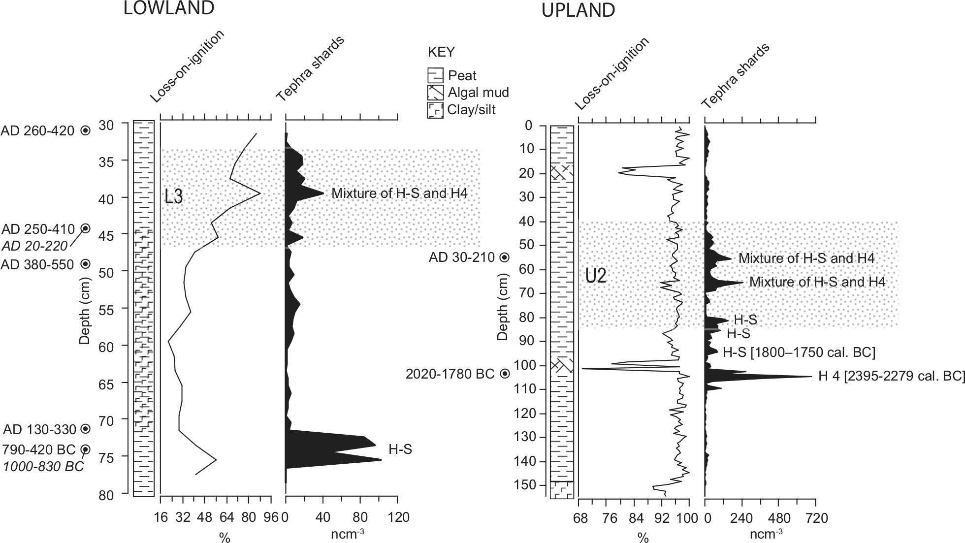
Stratigraphic information for both Underhoull profiles. The lithostratigraphy, tephrostratigraphy, loss-on-ignition results and calibrated 14C dates (2σ range) are shown. The stippled area refers to the pollen zone indicating the increase of Calluna and charcoal (see Figure 6). The interpretation of the tephra layers is based on the geochemical data shown in Figure 5. Dates in italics are those based on the humin fraction of the peat (lowland profile).
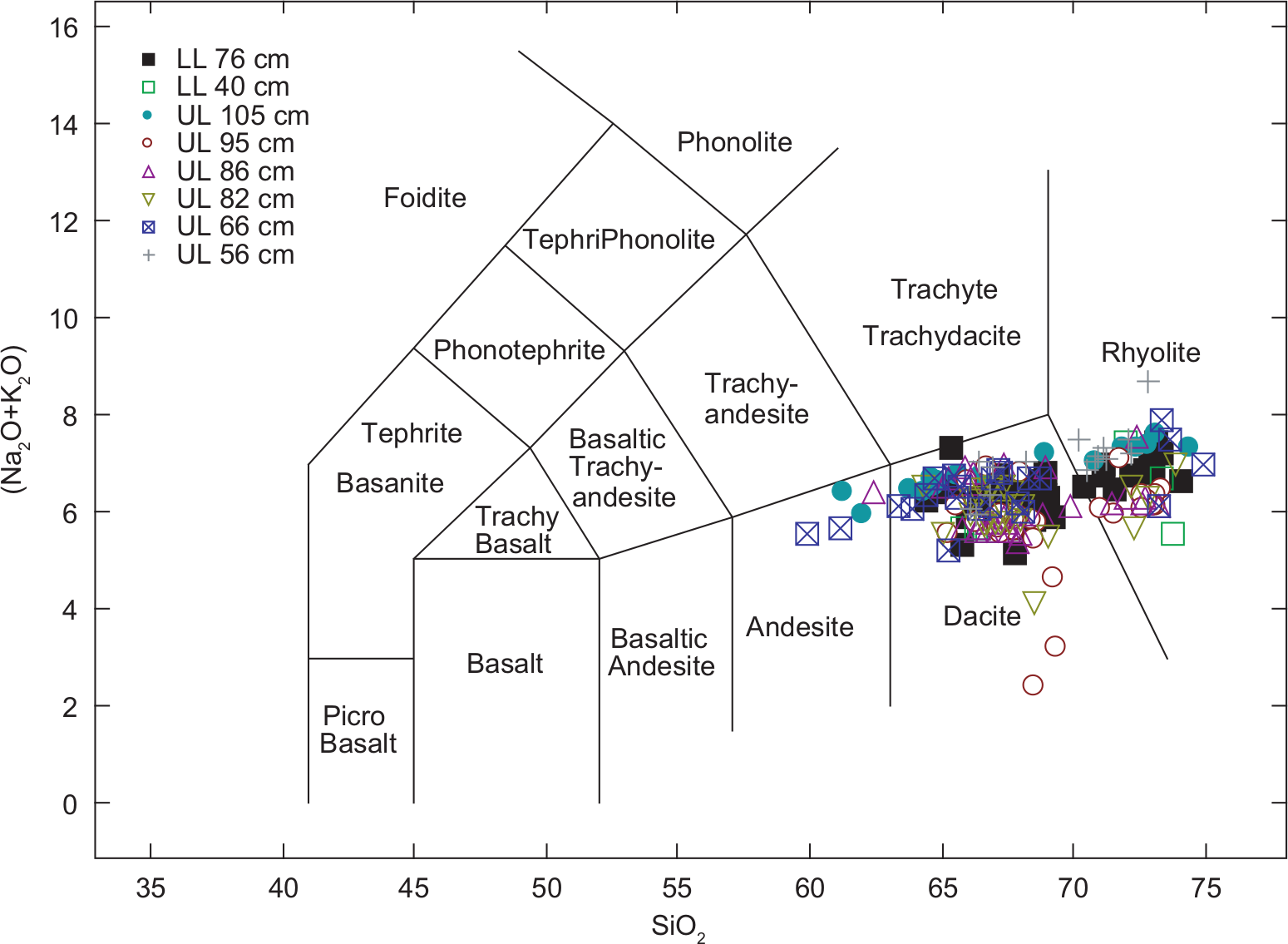
Total alkali–silica biplot of all tephras analysed from Underhoull.
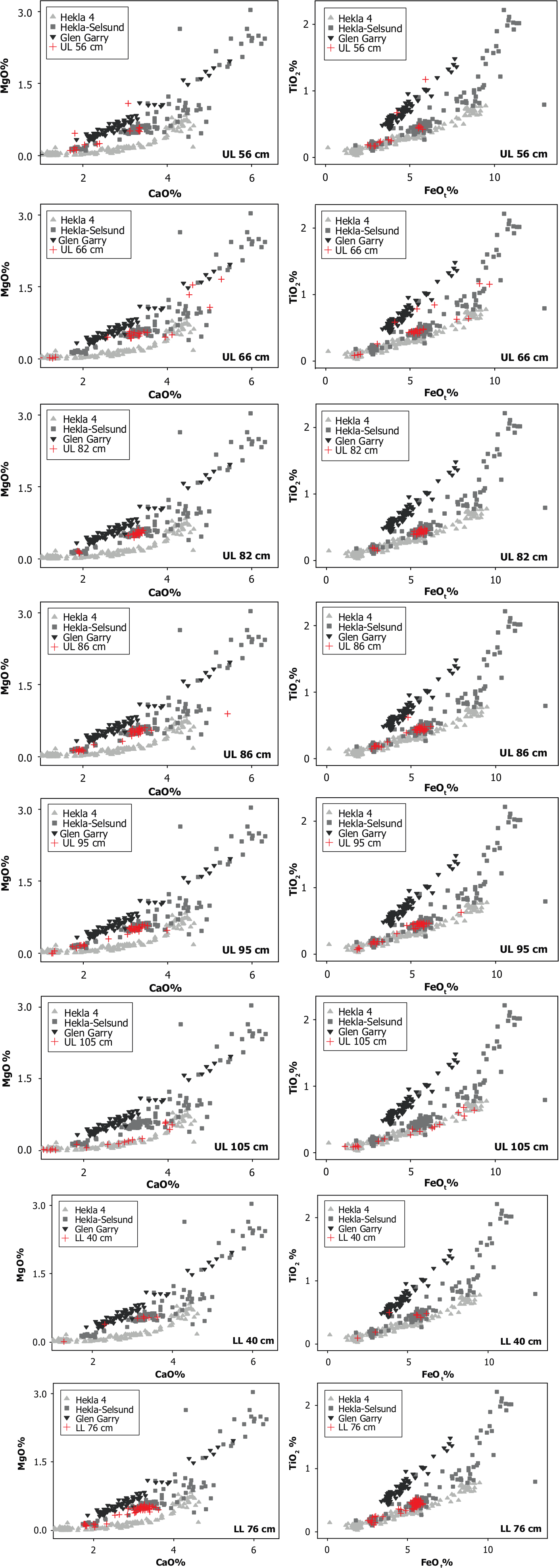
Tephra geochemistry biplots for (a) the upland profile and (b) the lowland profile. The type analyses for Hekla 4, Hekla-Selsund and Glen Garry are from Tephrabase (Newton et al., 2007). The Underhoull tephras are shown as red crosses.
A blurred peak (Hekla 4 – upland profile). The Plinian eruption responsible for Hekla 4 tephra probably lasted less than two days (24–30 h has been estimated by Larsen and Thórarinsson (1977)) and yet tephra grains are spread over ~10 cm representing several centuries of peat accumulation.
A split peak (Hekla-Selsund – lowland profile). The Hekla-Selsund tephra was also formed by a Plinian eruption, whose duration would have been similar to that which produced Hekla 4, and would have delivered to the site as discrete (subannual) event. The peaks in the lowland profile are separated by ~2 cm of stratigraphy representing at least several decades. This double-peak distribution is similar to that observed for the historical age tephra horizon at Loch Portain, North Uist (Dugmore et al., 1996).
Multiple peaks (Hekla-Selsund – upland profile). The multipeak distribution covers 20 cm of the stratigraphy, similar to the pattern inferred by x-ray imagery of Hekla 4 at in Profile 2 at Altnabreac, northern Scotland by Dugmore and Newton (1992). There are no other tephra layers involved in the redistribution. This implies a shallow/near surface set of processes following the initial deposition of the Hekla-Selsund tephra.
Mixed tephra peaks (Hekla-Selsund and Hekla 4 in both upland and lowland profiles). Tephra from different deposits originally separated by centuries/decimetres of stratigraphy have been remobilised and combined to create discrete peaks.
Radiocarbon dating of the peat profiles was also highly problematic (Table 1). In the lowland site the 14C dates do not represent a coherent chronosequence and the development of a statistical age–depth model was not possible. There are major differences between the dates on humic acids and those on humin; the latter was typically older by ~200–300 calendar years that may be due to mobility of the humic acid fraction (e.g. Shore et al., 1995). There is a very slow rate of peat accumulation in this profile and hiatuses or addition of carbon of different ages, through human activities such as burning of peat or old wood, is potentially present due to the Iron Age and Norse phases of activity recorded nearby. The 14C dates on humin and humic acid at the Hekla-Selsund tephra layer are approximately 1200–900 cal. yr younger than the tephra horizon suggests. However, there is a possibility that the Hekla-Selsund tephra in the lowland site may also represent inwash to the peat hollow, rather than the primary airfall deposit. The 14C date at the Hekla 4 layer in the upland site is also ~500 years younger than the accepted data of Hekla 4 (c. 2395–2279 cal.
AMS radiocarbon dates. Dates were calibrated using Calib 6.0.2 (Stuiver and Reimer, 1993) and the Intcal09 calibration curve (Reimer et al., 2009).
Pollen analysis from both the upland and lowland sites shows that the anomalous tephra layers occur during a phase of major landscape change, indicated by a rise in Calluna vulgaris pollen and a major increase in the abundance of microscopic charcoal (assemblage zones U2 and L3; Figure 6). A number of palaeoecological records from lakes in Shetland contain a marked rise in charcoal in association with the expansion of Calluna-dominated heathlands and moorlands (Bennett and Sharp, 1993a,b; Bennett et al., 1992, 1993; Edwards and Whittington, 1998; Edwards et al., 2005, 2009). The presence of charcoal may be due to deliberate burning of the landscape by humans to extend rough grazing areas (Edwards et al., 1995; Schofield et al., 2013), or it may reflect increased wildfire across heather-dominated plant communities as these are environments susceptible to natural fires (Gimingham, 1972). In addition, where grazing pressure is absent, Calluna will re-establish as the dominant vegetation type after burning (Rawes and Hobbs, 1979).
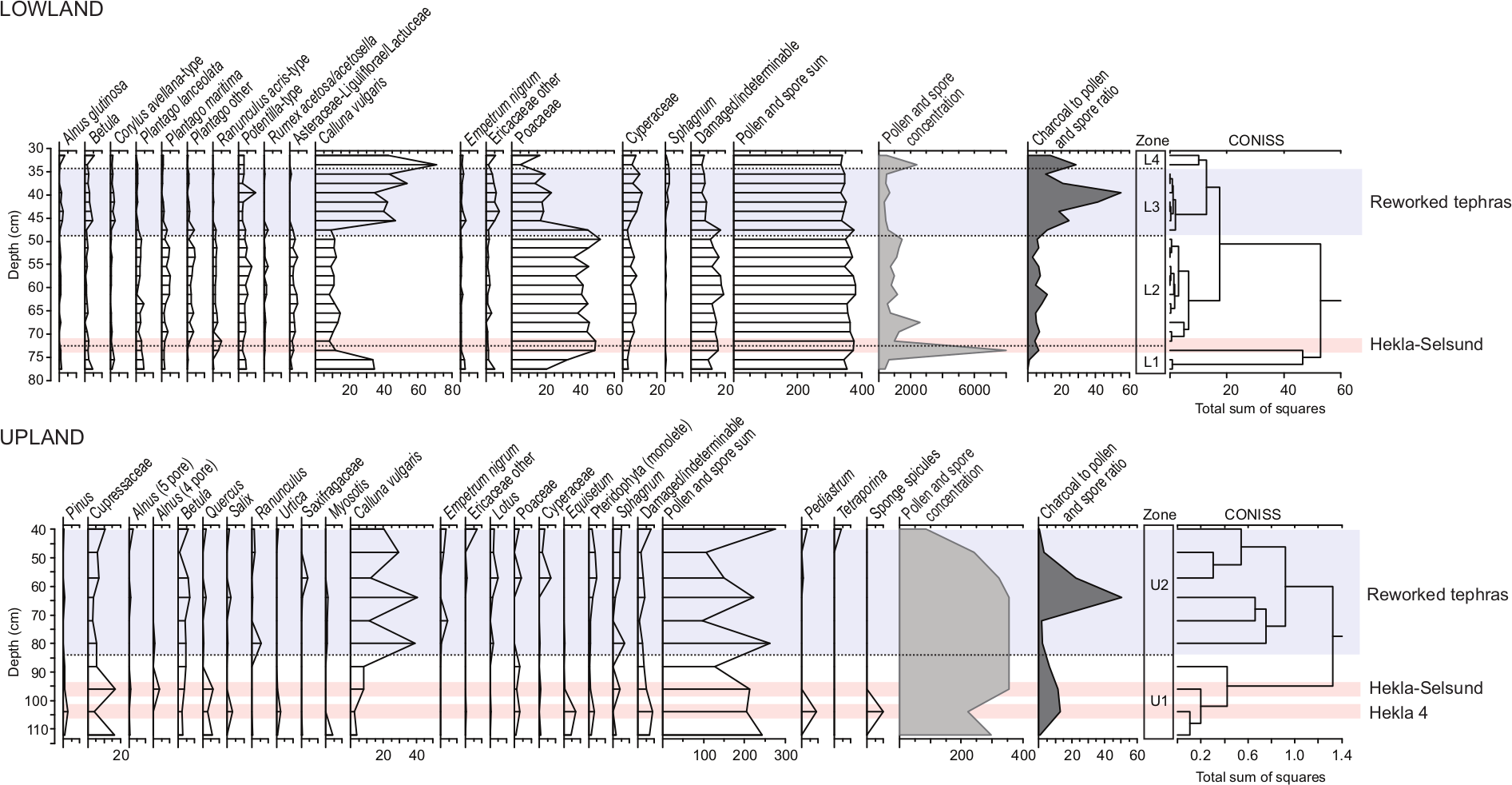
Percentage pollen data from the Underhoull profiles. Main taxa only are shown (taxa occurring equal to or greater than 2% in at least one sample). The pollen sum includes pollen and spores from terrestrial plants only. CONISS is based on relative abundance of pollen and spores from terrestrial plants. The depths of the tephra layers are shown.
There are widespread archaeological remains dating to the Iron Age in this area of Unst; the Broch of Underhoull and several smaller Iron Age structures are found within 200 m of the lowland site (Small, 1966; Figure 1). The expansion of heathland and/or moorland may reflect abandonment of this area in the first few centuries
Extensive erosion is a known outcome of fire in blanket peatlands (Tallis, 1998; Yeloff et al., 2006). Reworked tephra layers in both profiles at Underhoull may therefore be the product of the disturbance of peatlands triggered by either anthropogenic or natural burning. Fire in the peatlands led to the removal of vegetation and greater exposure of soils and other peatland surfaces, making these more susceptible to erosion (on the slopes and high ground above the lowland profile, and in the high bedrock ridge around the upland site). This could have promoted the concentration of tephra at the surface, followed by subsequent exposure and re-mobilisation by wind and water, and finally, re-deposition. We found no statistically significant difference between the percentage potassium or total alkali data in the primary and re-worked Hekla-Selsund tephras, suggesting that the temperatures of fires were not high enough to change shard chemistry (Figures 4 and 7). There is also no obvious morphological difference between the primary and reworked tephra grains. It is highly probable that the problems encountered when 14C dating these peats are also the product of the re-deposition of organic components of different ages. There is also a possibility of the re-working we identify here being a regional phenomenon, as re-working of both Hekla 4 and Hekla-Selsund has been observed in later Holocene peat and lake sequences in the Faroes (cf. Edwards et al., 2005; Lawson et al., 2007, 2008). In the case of the Faroes, climatically driven geomorphic and pedogenic disturbance is proposed as the driver, rather than anthropogenic activity, as humans did not settle in the Faroes until the first millennium
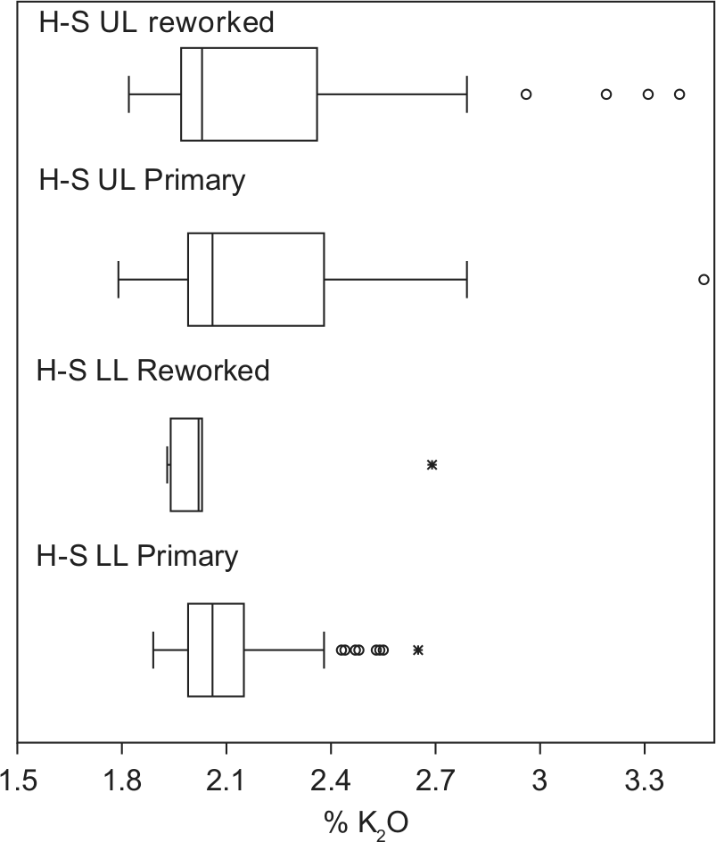
Boxplots comparing the % K2O data from the primary and re-worked Hekla-Selsund tephra layers.
Tephrochronology is a well-established tool for dating sediments and peats. However, a number of problems have been identified including spatial ‘patchiness’ of tephra layers at the regional scale (e.g. Dugmore et al., 1996; Payne et al., 2013; Rea et al., 2012) and taphonomic problems of re-working and redistribution in peatlands and in lake sediments (Boygle, 1999; Holmes 1998; Payne and Gehrels, 2010; Payne et al., 2005). In addition, the tephra layer with the highest concentration of glass shards may not necessarily represent a primary ash-fall layer but instead may reflect the re-deposition of eroded tephra from exposures or surfaces adjacent to a peat bog or lake (Swindles et al., 2010). The thickest layers in proximal areas do not always represent primary fallout (Dugmore and Newton, 2012). In this study we have clear evidence for different modes of redistribution of tephras at the landscape scale in relation to changing human activities and/or fire disturbance. Our results illustrate the need for high quality geochemical data before using tephra layers as isochrones and the importance of identifying the primary air fall deposit in sedimentary sequences.
Conclusions
Two proximal peatland tephra records from Unst in the Shetland Island, contain a tephra layer with geochemistry matching that of the widespread Hekla-Selsund isochron. In both profiles, distinct tephra peaks overlie this layer. These represent re-working of the Hekla-Selsund and older Hekla 4 layers rather than primary air-fall tephra deposits. Pollen analysis of the peat sequences shows that these reworked tephra layers occur at a time characterised by an increase in heather-dominated vegetation communities (heathland and moorland) and intensified burning in the landscape. Four modes of tephra reworking are identified, which reflect different rates of earth surface processes. We suggest that the reworked tephra layers in this study are indicators of wider landscape change, representing erosion of peat and the re-deposition of tephra shards. Tephrostratigraphies, including those composed of cryptotephras, can therefore provide important information about environmental processes within landscapes (erosion and deposition) as well as chronology (Dugmore and Newton, 2012). Our results also demonstrate the need for high quality geochemical data when using tephras as age-equivalent stratigraphic markers and highlight the use of palynology to place tephrostratigraphies in a wider landscape context.
Footnotes
Acknowledgements
We would like to thank Dr Chris Hayward (University of Edinburgh) and Dr Eric Condliffe (University of Leeds) for their advice on tephra geochemical analysis. Many thanks to Gill Plunkett and Keith Bennett (Queen’s University Belfast) for constructive comments on the pollen data. Many thanks to all staff and students involved in the Viking Unst project for their assistance in the field. We thank Linda Dancey, GSC-Calgary for pollen preparation. We also thank Dr James White and two anonymous reviewers for their helpful comments on the manuscript.
Funding
We thank the Shetland Amenity Trust for funding further geochemical analysis at the University of Leeds. The Viking Unst Project investigations at Underhoull were sponsored by Heritage Lottery Fund, European Agricultural Guidance and Guarantee Fund, Shetland Development Trust, Shetland Enterprise Company, Shetland Amenity Trust, Historic Scotland, Shetland Islands Council, and the University of Bradford, with additional funding from International Polar Year project ‘Long Term Human Ecodynamics in the Norse North Atlantic: cases of sustainability, survival, and collapse’ (NSF Award number 0732327). This research was also supported by grants from the Natural Environmental Research Council (UK) for 14C dating (allocations: 1493.0910, 1466.0410) and geochemical analysis of tephras at the School of GeoSciences, University of Edinburgh (allocation: TAU58/1109).
References
Supplementary Material
Please find the following supplemental material available below.
For Open Access articles published under a Creative Commons License, all supplemental material carries the same license as the article it is associated with.
For non-Open Access articles published, all supplemental material carries a non-exclusive license, and permission requests for re-use of supplemental material or any part of supplemental material shall be sent directly to the copyright owner as specified in the copyright notice associated with the article.