
Abstract
This paper reviews the state of avoided conversion of grassland and shrubland projects in nature-based solutions, by critically reviewing some of the leading protocols for quantifying emission reductions (ERs) in this sector and discussing some of their methodological and logistical flaws. We reviewed the available literature at a global scale over the past decade. By reviewing methodologies like Verra's VCS VM0009, American Carbon Registry's ACoGS methodology, and Climate Action Reserve's US Grasslands protocol, this review identifies common concerns such as inadequate guidance on field data collection, the exclusion of grazing from baseline scenarios, and failure to properly account for ecological factors affecting carbon fluxes in grasslands and savannas. This review is the first of its kind to critically evaluate the limited options for ACoGS—a critical area of nature-based climate solutions—through the lens of connecting methodological processes to real-life applications. To improve upon the identified flaws, we also provide a brief snapshot of elements which must go into making an improved protocol, such as expanding the scope of methodologies to include common drivers of land-conversion like grazing, expanding the utilization of remote sensing technologies to monitor project activities, and exploring the utilization of other ecological measures to quantify carbon fluxes, such as ecosystem energy balances. The findings of this review will be directly impactful for project developers, proponents (landowners) looking to get involved in carbon markets, to registries/standards, and rating agencies which are emerging standard bearers of integrity that seek to better understand market forces and the evolving science behind these methodologies.
Introduction
The atmospheric CO2 has steadily increased from 280 ppm since the industrial revolution in 1750 and surpassed 400 ppm in 2016. The current average CO2 concentration is 423 parts per million (ppm). The rapid increase in atmospheric CO2, which is unprecedented in the past 800,000 years, is attributed to human activities such as the burning of fossil fuels and deforestation, leading to global warming and climate change. It is worth noting that ongoing efforts are being made to monitor and address the issue of rapid rise in atmospheric CO2 concentration through various international agreements and initiatives. Article 6 of the Paris Agreement is one such instrument that aims to create a framework for international cooperation in the form of a carbon market. This market is designed to enhance the cost-effectiveness of climate change mitigation efforts by allowing countries to voluntarily trade emissions reductions (ERs) to achieve ER targets set out in their nationally determined contributions. Article 6 establishes a mechanism for trading greenhouse gas emission (GHG) reductions (including CO2) between countries under the supervision of the Conference of the Parties, within the United Nations Framework Convention on Climate Change.
Overview of carbon markets
Carbon markets operate on the principle of trading emissions allowances, providing economic incentives for companies and organizations to limit their carbon footprint. By putting a price on carbon emissions, these markets aim to encourage investment in cleaner technologies and practices, ultimately reducing atmospheric CO2 concentrations. The connection between carbon markets and atmospheric CO2 concentration lies in the potential for these markets to drive emission reductions. As companies strive to comply with emissions limits and trade allowances, they are incentivized to adopt greener practices, invest in renewable energy, and fund projects that mitigate CO2 emissions. While carbon markets are just one tool in the broader effort to address climate change, they can play a significant role in the global effort to reduce atmospheric CO2 concentrations. Carbon markets officially took root in the 1997 clean development mechanism as part of the Kyoto Protocol and were restructured in 2015 under Article 6 of UN's Paris Climate Accord. 1 Today, the United Nations Framework Convention on Climate Change has a near-universal membership of 198 countries, with the goal of “preventing dangerous anthropogenic (human-induced) interference with the climate system.”
Carbon markets are largely broken down into two categories: compliance markets and voluntary markets. In simple terms, compliance markets such as California Cap-and-Trade or the European Union's emissions trading system are government regulated and limit GHG emissions to a certain threshold, while allowing participants to “trade” their remaining allowance. On the other hand, voluntary carbon markets (VCMs) are reliant upon carbon credits, which can be “voluntarily” purchased to offset corporate emissions, creating financial incentives for organizations and industries to limit their emissions while investing in projects that mitigate GHG emissions. While carbon credits have come under criticism several times since inception, VCMs are still a critical pathway to climate change mitigation, reliably financing climate resiliency through projects that are largely concentrated in the underdeveloped “global south.”2,3 As corporations pledge to become carbon neutral in the coming decades, the global demand for carbon credits is projected to increase by a factor of 100 by 2050, with a valuation of up to USD 50B. 4
VCMs
VCMs mainly comprise two credit types: nature-based solutions (NBSs) and technology-based solutions. According to Sylvera's State of Carbon Credits 5 report, NBSs are the largest category within VCMs and continue to receive the most investment, with projects ranging from forest or grassland restoration to increasing agricultural soil organic carbon (SOC) sequestration. Technology-based solutions also play a substantial role in VCMs along with NBS, with projects involving renewable energy, increasing energy efficiency, or artificial carbon capture. In both credit types, projects are typically categorized as “avoidance” or “removal” credits, each unit representing 1 tCO2e (metric-ton of CO2, equivalent) for the proposed duration of the project.
Nature-based avoidance
Within NBS, the “avoidance” project category faces challenges in baseline setting, leakage, and additionality quantification. Nevertheless, avoidance projects represent the largest proportion of NBS credits, largely concentrated in forests. The challenging aspect of NBS avoidance projects is quantifying project ERs, which depends on the quantification of “additionality,” a measure of the incentive for land conversion, and the “baseline,” the state of land use in the absence of the project activity. While the agent of conversion is often known, typically deforestation or conversion to cropland, project developers must accurately determine the rate at which land conversion takes place. Unfortunately, this is a usually difficult undertaking as it requires geospatial analysis which is costly and time-intensive, serving as a significant barrier to developing quality carbon projects.
Grassland and shrubland carbon sequestration
Grasslands and shrublands play a significant role in carbon sequestration and can be considered as NBSs for climate change mitigation. Grassland and shrubland ecosystems (GSEs) often have extensive root systems, which contribute to the accumulation of organic matter in the soil. This organic matter helps sequester carbon over time, as decomposed plant material becomes part of the soil structure. Healthy GSEs contribute to overall ecosystem resilience. Resilient ecosystems are better able to adapt to changing climate conditions, maintaining their capacity for carbon sequestration over time.
It is important to note that the effectiveness of GSEs as carbon sinks can vary depending on factors such as climate, soil type, and land management practices. Implementing NBS in these ecosystems requires a comprehensive approach that considers both ecological and socioeconomic factors. Local communities, landowners, and policymakers play crucial roles in the success of these initiatives.
Grassland ecosystems are a nascent but growing sector within NBS. Globally, grasslands comprise around 25% of the earth's surface and 12% of terrestrial carbon stocks, along with several biodiversity and ecosystem benefits.6,7 Although grasslands are considered to be a more resilient carbon sink than forests, grasslands have traditionally comprised a much smaller carbon pool within NBS. 8 However, in recent years, there has been a growing interest in carbon project initiatives on grassland restoration and protection, and the United Nations estimates around 24% of NBS credits to come from grassland or cropland projects by 2050, with the other 62% from forests and 4% from wetlands. 9 Within the grassland and cropland category, the “removals” project category has made significant strides in the past decade, contributing to the development of robust quantification and monitoring frameworks. Methodologies applicable to this category are Verra's VM0026 (sustainable grassland management), VM0042 (improved agricultural land management), and VM0032 (adjustment of fire and grazing).
The grassland-based “avoidance” (i.e., ACoGS) sector has received considerably less attention, and the sector suffers from a lack of development, mainly due to challenges in baseline, additionality leakage quantification, and monitoring concerns. Grassland-based avoidance projects currently face the absence of scientifically robust quantification frameworks and monitoring protocols for tracking land conversion events using satellite-based remote sensing, which is crucial in determining baseline scenarios and monitoring project activities in avoidance project types. Unfortunately, most forest-based methodologies and measurement, reporting, and verification (MRV) solutions are often inapplicable to grasslands due to the complexity in detecting the drivers of conversion. For instance, deforestation is much easier to detect than grassland conversions, as forest land cover is generally impervious to changes induced by weather and precipitation. Moreover, the contrast between forest and nonforest is much more prominently picked up by satellite imagery than changes in management practices on grasslands or natural, inter-, and intra-annual fluctuations because of phenological cycles, variations in rainfall patterns, changes in grazing intensity, and many others.
Potential causes of an underdeveloped ACoGS sector
The underdeveloped state of the ACoGS sector in NBS can be attributed to several potential factors, although there is no single factor clearly outweighing the rest. First, the cost and time required for project developers and registries may outweigh the return on investment, especially in ecosystems where organic carbon is naturally low (e.g., semiarid grasslands) and increased carbon sequestration does not always correlate with improved land management or greater ecosystem health. This concept is exemplified by the issue of shrub encroachment discussed in the sections below, wherein poor land management, and an unnatural, shrub-encroached state corresponds to higher above-ground carbon (AGC) stores, even though it compromises on ecosystem health and integrity.
Additionally, a standardized scientific method for measuring and tracking carbon fluxes in an accurate and globally applicable way is not yet available for ACoGS projects. For instance, the VM0009 methodology (now deactivated) models grassland degradation based on an economic theory of resource consumption, primarily used for deforestation, whereas the Climate Action Reserve (ACR) ACoGS methodology and CAR US Grasslands protocol calculate ERs through the prevention of grassland conversion to croplands. None of these methodologies allows grazing to be the main driver of conversion and differ in their ways of modeling land conversion. A fundamental challenge with ACoGS (and avoided conversion projects at large) is that they are based on preventing conversion to a scenario which has not yet occurred, making it difficult to estimate the most likely alternate land use scenario (ALS) and the timeline for land conversion. While certain protocols are excellent for certain ALS types in limited ecosystems (e.g., conversion of croplands in certain U.S. counties, under ACR ACoGS protocol), there is not a single approach which encompasses the multiple ALS types and ecosystems, especially where grazing is a predominant land-use category. A potential solution to this has further been described in the Improved ACoGS Framework section of this paper.
Finally, the structure of the carbon market makes it difficult for ACoGS projects and methodologies to progress and mature. The first major flaw of carbon markets is that vanguard project developers bear the brunt of the overhead cost of putting together a technical team to create the methodology, getting the methodology validated and reviewed by the registry, on top of paying for their own project's validation and verification, which can be a years-long process, while the project developer must continue to perform project activities without any external environmental prefinancing (in most cases). Second, choosing the right ALS and modeling land conversion are fundamentally difficult in the ACoGS sector, as compared to ecosystems such as forests, in which the ALS is usually clear: deforestation, which is relatively straightforward to model. Even though many grasslands only have a handful of land use cases, such as agriculture and ranching, modeling of land conversion can vary based on the ecosystem type and amount of information available. It is also relatively hard to detect grassland degradation using satellite imagery (unlike forests), making them difficult to continuously remotely monitor. Finally, credits from avoidance projects have much lower demand in carbon markets than those from removal projects since carbon removal is associated with greater permanence in sequestration, even though both are equally as important to nature conservation and restoration at large. These challenges make the return on investment difficult to justify, hindering the development of new sectors in NBSs, such as ACoGS.
The paper is the first of its kind to critically evaluate the limited options for ACoGS—a critical area of nature-based climate solutions—through the lens of connecting methodological processes to real-life applications such as in Kalahari. The Kalahari covers over 900,000 km2 and has incredible carbon sequestration potential. 10 Additionally, the area is rich with biodiversity and wildlife—which in recent decades have experienced significant decline due to pressures from grazing, agriculture, and unsustainable rangeland management. This combined with climate challenges results in a challenging environment for wildlife conservation threatening the Kalahari making ACoGS type projects a perfect fit—avoiding the conversion of remaining wilderness areas and promoting proactive management of wildlife, stocking densities, and such. Therefore, the Kalahari was used as an example for what ACoGS projects could accomplish and it serves as a prime example for how real-life use cases are sometimes divorced from reality (i.e., how certain methodological provisions, requirements, and processes do not apply or function with realities in areas like the Kalahari). For example, some of these methodologies do not even allow grazing as the baseline scenario, which is an issue since it is the primary driver of conversion in the Kalahari.
The paper suggests using the use of stocking densities to better model baseline scenarios (i.e., what happens in the absence of an ACoGS project where grazing is the primary driver of conversion). This is a truly novel area as no existing methodology validated across the major registries uses this approach. By modeling the change in stocking densities between say area A and area B, a population growth model serves as the model of conversion over time. This annual or seasonal proportion of conversion/time when applied to the difference in baseline carbon stocks can yield a significantly more realistic measure of emissions avoided. In terms of real-life application, this is a direct call to action for actors in the carbon market to consider practical improvements that can be made to future and existing ACoGS methodologies for protecting our planet's rangelands. This will be directly impactful for project developers, proponents (landowners) looking to get involved in carbon markets, to registries/standards, and rating agencies which are emerging standard bearers of integrity that seek to better understand market forces and the evolving science behind these methodologies.
ACoGS methodology review
The conversion of grassland and shrublands to land use types impeding carbon sequestration or introducing ecosystemic imbalance (e.g., through overgrazing and subsequent desertification or shrub encroachment is one of the leading causes of grassland loss). 11 However, the programs for quantifying carbon credits from avoided conversion of grasslands and shrublands (ACoGS) projects are still scientifically questionable and are restricted to a very limited set of land conversion scenarios. To date, the only carbon credit quantification frameworks applicable to ACoGS project types are Verra's VM0009 (VCS VM0009), the American Carbon Registry's ACoGS methodology (ACR ACoGS), and the Climate Action Reserve's US Grasslands Protocol (CAR USGP). These frameworks have sprung up in the early 2010s, but despite minor updates throughout the years continue to be scientifically questionable or practically difficult to implement. These methodologies have been thoroughly examined in this section, with commentary provided on areas of improvement.
These methodologies were selected in particular because they are the only methodologies for GHG accounting available to proponents (landowners) and developers of carbon projects that are directly applicable to ACOGS (avoided grassland conversion) project activities across the major registries (Verra, GS, ACR, and CAR). During the review process, the methodologies were read, thoroughly analyzed by our team to understand the quantification process, and key shortcoming were identified in the context of ACoGS. These key findings were then summarized for each methodology and then were synthesized for suggesting areas of improvement for future projects and methodologies.
Overview of ACoGS
ACoGS involves keeping well-maintained grassland ecosystems intact, and needs separate GHG quantification protocols, as the application of grassland-based carbon “removal” methodologies often requires increasing carbon sequestration through project activities, often infeasible for areas already at their best management level, which have high incentive of conversion to less sustainable practices. Existing ACoGS frameworks estimate avoided GHG emission by calculating the amount of ERs taking place by preventing the conversion to croplands, but often exclude the baseline scenario of land conversion due to grazing. While current frameworks aim to accurately estimate avoided emissions, there are a few noteworthy scientific concerns and implementation challenges which are discussed below.
Brief history of ACoGS
Since the beginning of the past decade (2010s), carbon markets have been on the rise, along with a spring-up of several methodologies for ACoGS. The VM0009 methodology was developed under Verra's VCS program by Wildlife Works in early 2011, initially focused on forest baseline types. Over the years, it underwent several updates, including its expansion to grassland baseline types in 2014, before being deactivated in November 2023, with projects initiated before February 2024 allowed to continue. The ACR ACoGS methodology, created in 2013 under the American Carbon Registry by organizations such as Ducks Unlimited and The Nature Conservancy, targets grassland ecosystems in the United States to prevent conversion to croplands. This methodology evolved from v1.0 to v2.0, simplifying project development and reducing costs while maintaining accuracy. Meanwhile, the CAR USGP methodology, first introduced on 22 July 2015, underwent revisions in 2017 and 2020, with its latest version offering more flexibility for project expansion and land protection while ensuring stringent GHG quantification and long-term ecosystem sustainability.
Common shortcomings in ACoGS frameworks
Some of the common shortcomings in existing ACoGS frameworks are illustrated in Figure 1. The shortcomings include: (1) inadequate guidance on field data collection, data processing guidelines, and usage; (2) exclusion of grazing (by wildlife and/or livestock) as a driver of conversion as well as a natural driver of ecosystem balance from the baseline scenario; (3) lack of explicit inclusion of savanna ecosystems; and (4) natural and anthropogenic activities such as biomass burning not taken into account, which are discussed in detail in this subsection.
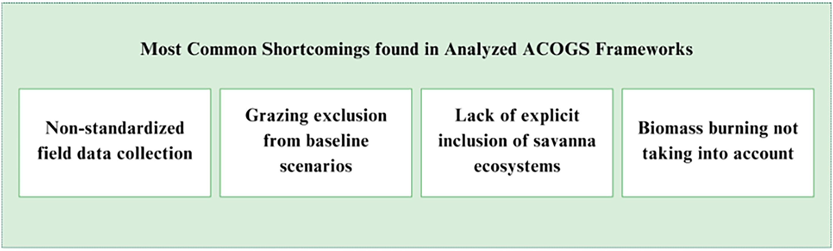
Most common shortcoming found in analyzed ACOGS frameworks.
Nonstandardized field data collection
Many methodologies in the agriculture, forestry and other land use sector rely on field measurement to accurately quantify carbon stored in above and below-ground biomass. However, current methodologies differ in their field sampling guidelines lacking standardized protocols for grassland sampling. This is partly due to the lack of a grassland-specific field sampling tool by international agencies such as the United Nations, which pioneered many of the initial tools for forest-based field sampling under its clean development mechanism tools.
Hence, methodologies such as ACR's ACoGS do not provide any specific guidelines on field sampling and instead encourage project developers to use default values for biomass and soil carbon established under credible sources such as scientific or government-affiliated institutions. The lack of locally available data sets such as soil type, salinity, and differences in seasonality have led to intentional/unintentional errors and overestimations of carbon offsets. For instance, the application of savanna parameters determined in Kruger N.P. to other ecosystems such as the Kalahari might lead to misleading results. While other methodologies such as VCS VM0009 suggest project developers perform field measurement, little guidance is provided to ensure that sample measurements are an accurate representation of the entire population being sampled, and sampling is consistent.
Grazing is excluded from the baseline scenario
None of the existing ACoGS frameworks allows grazing/overgrazing on land to be an agent/driver of conversion, which can be problematic for projects located in regions where grazing activities are the most likely ALS and might be the only driver of land conversion. As highlighted by the intergovernmental panel on climate change (IPCC) report, 12 overgrazing is one of the major causes of desertification in semiarid grasslands across the world, such as parts of South Asia, the Middle East, Africa, and Australia, where crop productivity is naturally low, and livestock rearing is the main form of subsistence.
One of the methods of baseline determination under current ACoGS frameworks is a demonstration of the land use conversion scenario of cropland in the absence of the project activity. This is a challenge because ecosystems such as shrublands and grasslands in some parts of the world are not suitable for crop production (Food and Agriculture Organization, UN). These types of grasslands include large parts of western and southern Africa, Australia, the American Southwest, Mongolia, the Tibet Autonomous Region in China, and Patagonia and therefore exclude most of the grassland potentially threatened. A combination of factors such as climate and soil fertility render these grasslands unsuitable for economically relevant cultivation of crops, making grazing, instead of cropland, the most likely agent of conversion. Examples of overgrazing leading to significant depreciation of carbon stocks and loss of ecosystems and associated biodiversity can be given in several global contexts; however, they can be most pronounced in South American grasslands and the North African Sahel zone, large parts of southern Africa and many other places, where a vast majority of conversion has occurred recently (within the last century). For example, grasslands in Patagonia have been used for intensive sheep production for little over a century, and the vegetation dynamics have been significantly modified by the presence of livestock as compared to grazing patterns from native herbivores. The conversion of other South American grasslands such as the Campos, Pampas, and Cerrado to pasture/rangelands was also shown to have impacts on the soil's hydrophysical properties, reduction in evapotranspiration, and increased streamflow. 13 While some sources suggest that grassland degradation is in most cases a symptom of mismanaged pastoral systems (UN FAO), others argue that the role of grazing in carbon cycling and fire management is still a debatable topic. 14 Nevertheless, it is critical to consider other grassland conversion scenarios than cropland.
Furthermore, it is important to acknowledge that increasing sequestration is not always feasible for projects already performing the best management practices or in ecosystems with naturally low sequestration capacity, such as semiarid regions. Additionally, an increase in carbon sequestration is not the sole determiner of healthy ecosystem functioning, and altering land management practices to amplify sequestration without knowledge of the native ecosystem can risk the disruption of ecological balance.
Savanna ecosystems are unaddressed
Another concern about current ACoGS frameworks is that they do not explicitly address savanna ecosystems in their methodologies, which are significant carbon sinks due to their higher above-ground biomass availability. Savannas are similar to grasslands but often serve as a transitional zone between forests, grasslands, and deserts. While savannas can be classified into various types, such as grass-savannas, shrub-savannas or tree-savannas, their application to ACoGS frameworks is more or less similar. 15
Globally, savannas cover about 30 million km2, which translates to about 20% of the Earth's land surface16–19. Savannas are found on all continents except for Antarctica, with Africa comprising the largest area, covering about 40%–50% of the continent's surface.20–22 Home to slightly over 30% of the world's human population, savannas support livestock rearing, crop production, and wildlife-based ecotourism industries. 23 They contain about 15% of global SOC, making them an important carbon sink and a stronghold for protecting biodiversity.24,25 In addition, savannas are remarkably productive ecosystems, with an average net ecosystem productivity of 0.39 Gt C year−1, translating to roughly 30% of global terrestrial net productivity. 22 Hence, it is important to explicitly include savanna ecosystems in the ACoGS methodologies, especially in the context of conversion to cropland or intense grazing pressures.
In many savanna ecosystems, land use change tends to be biased toward the intensification of livestock production at the expense of plant and animal biodiversity. In southern African countries such as Botswana, local populations do not perceive nature-based ventures such as wildlife conservation or ecotourism as major sources of income, and largely rear livestock and cultivate land for subsistence. 26 When compared to wildlife-based economic opportunities, livestock-based ventures are relatively less capital intensive and are accepted as modern and traditional norms. Furthermore, local governments in countries like Botswana are experiencing increasing pressure from the local population to convert wildlife management areas (WMAs) into commercial livestock ranching areas, as exemplified by a recent dezoning of an 8268 km2 WMA and convert existing WMA into communal grazing lands. 27
In South America, vast stretches of savannas are also being converted to croplands. For instance, over the past few decades, Brazil's savannas have been cleared to make room for lucrative cash crops such as soybeans, which represent 90% of all agriculture in Brazil's savannas.28,29 The risk of converting native savannas to livestock or crop-based ventures is partly due to the lack of precedent and financial barriers in nature-based ventures. Unfortunately, most well-managed savannas, despite holding significant carbon sinks, are ineligible to take advantage of today's carbon financing due to inadequate inclusion within current ACoGS protocols.
Biomass burning not taken into account
Fire is an integral part of the Earth's systems that have influenced the land atmosphere for millions of years, 30 and fire-prone ecosystems cover 40% of the land surface, including major global biomes such as grasslands, shrublands, savannas, and boreal forests. Collectively, these fire-prone ecosystems are responsible for more than 85% of global fires.31,32 Depending on their frequency and severity, fires can reduce plant biomass and can also replace woodlands with shrublands or grasslands. 33 Moreover, grasslands and savannas are some of the most fire-prone ecosystems, responsible for 65% of the gross global mean fire emissions, where total global fire emissions are 8 Pg CO2eq yr−1. 34
In Africa alone, savannas account for 88% of annual total burned area, and grasslands, shrublands, and croplands account for about 5%, 13%, and 6% respectively. 10 In Australia, savanna fires contribute about 3% of annual GHG emissions, 14 and changes in land use in these fire-prone ecosystems can significantly alter naturally occurring fire regimes. For instance, the conversion of grassland to cropland might lead to a decrease in fire frequency but increase in fire severity; therefore, shifting carbon fluxes and dynamics from fire regimes must be adequately accounted for within GHG quantification frameworks. However, it is important to underscore that if we burn biomass on a carbon project (e.g., encroaching shrubs), then the emissions resulting from that burning of biomass must be accounted for and deducted from emission reduction claims the project is making for integrity purposes.
Moreover, it is important to point out the adaptations undergone by vegetation in fire-prone ecosystems and its effect on carbon fluxes. As an adaptation mechanism for fire, many plant species preferentially allocate biomass below ground to ensure recovery capability after fire events. Fire events may affect root traits and distribution in several indirect ways, including through changes in vegetation structure or soil properties. 35 There is sufficient evidence from both experimental studies and field observations 36 that fire-prone plant species experiencing frequent fires have a larger root mass fraction than those growing free from fires both at the individual species level and ecosystem level, and increased fire frequency could stimulate vegetation to produce finer roots, which have a high turnover rate. Root turnover is a critical component of ecosystem nutrient dynamics and carbon sequestration and is also an important sink for plant primary productivity. 37 On the contrary, long periods without fire may lead to changes in grass composition or woody encroachment, whereas frequent fire will often favor the dominance of grass species, which might lead to an increase in SOC.
In a recent publication, 38 argue that improved savanna fire management can generate enough carbon revenue to help restore Africa's savannas, build ecosystem resilience, and reduce threats to biodiversity. In the absence of fire management, fire return intervals in native savanna ecosystems could be as high as 4 years, and on savannas with high fire-suppression efforts, return intervals could be up to 10 years or more, 39 as illustrated in Figure 2. Due to the critical role which fire plays on grassland, shrubland, and savanna systems, it is imperative to take into account biomass burning when estimating avoided GHG emissions.
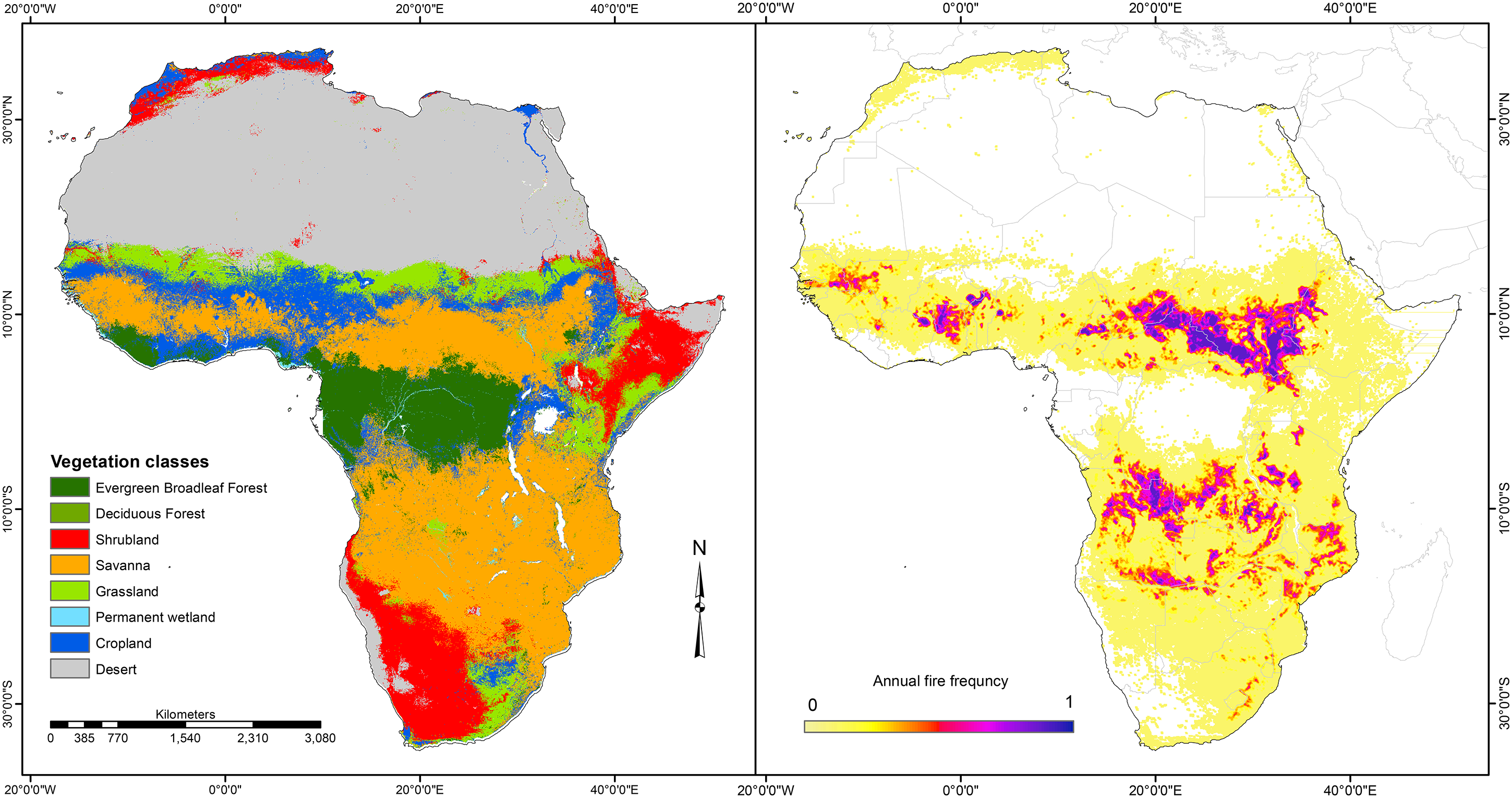
Vegetation and fire regimes in subsaharan Africa. Source: Dintwe et al. 10
Shrub encroachment not addressed
Shrub encroachment refers to the process where shrubs, typically woody plants, expand their coverage within ecosystems, particularly in semiarid grassland regions. This phenomenon is commonly observed in various parts of the world, including the Great Plains in North America, the savannas of Africa, and the steppes of Eurasia. Grasslands are vital for carbon storage, and shrub encroachment alters the balance of carbon storage as shrubs store carbon differently from grasses. While grasslands can sequester carbon in their roots and soil, shrubs store more carbon above ground, which can affect the overall carbon balance in the ecosystem. 24
Addressing the impact of shrub encroachment on grassland carbon credit projects within the ACoGS sector is crucial. Shrub encroachment, while increasing AGC storage, significantly disrupts the natural carbon balance and ecosystem functioning of grasslands. Existing ACoGS methodologies primarily target the protection of grasslands from conversion to alternative land uses that degrade biomass carbon, but they overlook the specific threat of shrub encroachment.
Shrubs increased carbon storage above-ground might seem advantageous; yet, the damage from an ecological standpoint outweighs the benefits in mere carbon stocks. Shrub encroachment alters biodiversity, disrupts water resources, and negatively impacts the economic viability of grassland-dependent economic activities, such as livestock production or wildlife-related activities. Highlighting the detrimental effects of shrub encroachment on ecosystem health, biodiversity, and water availability underscores the need to revise ACoGS methodologies to address this overlooked threat. By acknowledging the adverse impacts of shrub encroachment on grassland ecosystems, these protocols can better preserve the holistic integrity of carbon sequestration efforts, ensuring they align with the long-term sustainability of these vital ecosystems.
VCS VM0009
Verra's VCS VM0009 is one of the few methodologies applicable to the avoided conversion of grasslands. Being the only active Verra methodology allowing for ACoGS, it also qualifies under the reducing emissions from deforestation and forest degradation (REDD) framework. There are currently 24 total projects utilizing VM0009 under VCS, with 11 officially registered, seven under validation, three under development, and two on-hold. Out of the 24 listed projects, only two are performing ACoGS, the rest being REDD (Verra Registry). In January 2023, Verra's REDD project framework received criticism from The Guardian for over crediting due to flawed baseline determination frameworks, leading Verra on the path to review and replace its five REDD methodologies (including VM0009) with a new Consolidated REDD Methodology by 2025.40–42 More specifically, the Kariba REDD + project, which uses the VM0009 methodology recently had its credits suspended by Verra after facing criticism from The New Yorker for overestimating its ERs. 43 The project was accused of assuming that around 96% of the land's sequestered carbon would be converted to GHGs in the absence of the project, which might be inaccurate. While Verra's new methodology aims to fix some of the baselining and monitoring flaws in the existing approaches, it is only focused on forests and does not include grassland baseline types, solidifying the need for revised, more scientifically robust protocols in ACoGS.
The VM0009 methodology was developed under Verra's VCS program, by a project developer named Wildlife Works in early 2011 without a public consultation, initially only eligible to forest baseline types. Since inception, the methodology experienced several updates and amendments to its forest baseline types and was only opened up to grassland baseline types in its latest and final revision in 2014. The methodology continued to be active for the subsequent years, until it was deactivated in November 2023, under the condition that all projects which had initiated validation prior to February 2024. To date, there are only 13 VM0009 projects, under VCS, 12 of which are of the reducing emissions from deforestation and forest degradation (REDD) sectoral scope and only one supporting ACoGS.
To summarize VM0009's existing approach, the methodology requires project developers to select a reference area representing the likely ALS of the project area in absence of the project's existence. Then, historical satellite imagery analysis can be performed on the reference area to analyze land conversion rate, on which logistic regression is performed, which is then used to model the future state of biomass on the project area. From here, field measurements are conducted on both the project and proxy areas (representing the ALS), which are plugged into the biomass emissions models (BMEs) along with parameters from the logistic curve. Additionally, project developers must also prove the risk to land conversion using Verra's VT0001 additionality tool, and perform non-permanence risk analysis. Issuable credits are then determined after setting aside buffer pools based on risk calculations. While VM0009 is sound in some respects, it also has scientific and logistical concerns as outlined below:
No safeguards against “baseline gaming”
VM0009 lacks substantial safeguards against baseline-gaming, which involves choosing an unlikely baseline scenario, to artificially increase the volume of credits generated. Under VM0009, emissions reductions mainly depend on two major components: (1) the difference in biomass stocks calculated between the project and proxy areas and (2) the amount of time it takes for a reference area to undergo conversion. (The proxy area and reference area are both representing the ALS (Alternate Land-use Scenario). However, the proxy area is strictly the area where field measurements for the ALS are conducted, whereas the reference area is strictly for performing LULC analysis (to determine the rate of land-conversion). Further details specifying the requirements for proxy and reference areas can be found in the methodology.) Project developers are required to choose reference areas within a certain proximity of the project accounting area, depending on the baseline type; however, project developers ultimately choose reference and proxy areas (“ALS areas”), with few safeguards put in place for avoiding overcrediting.
Logistic conversion might not apply to grasslands
The main mechanism for calculating emissions reductions within VM0009 are the BEMs, which rely on deforestation following a logistic conversion curve. The BEMs take into account various field measured parameters about biomass and other covariates around the project area such as soil decay rates and information from participatory rural appraisals to model degradation of biomass over time. While projected degradation is modeled on the logistic curve obtained from historical imagery analysis, the idea of modeling ecosystem degradation with a logistic curve may only be accurate on forests, not grasslands. Furthermore, BEMs do not consider the inter-annual and intra-annual variation of biomass due to seasonality and fluctuation in weather patterns. The application of the logistic comes from the economic theory of natural resource consumption, which was initially derived only for forest ecosystems, and there is a paucity of literature suggesting this approach to be accurate on grassland and shrubland ecosystems; rather, given the high variability of vegetation in grassland ecosystems, the logistic pattern is certainly inaccurate for ACoGS, warranting the need for exploring new approaches.
Grazing not allowed as driver of conversion
It is important to include grazing within the baseline scenario type for ACoGS projects, as overgrazing is one of the main threats to the conservation of grassland ecosystems around the world; overgrazing not only makes ecosystems vulnerable to desertification or shrub encroachment but also jeopardizes the land's future ability to sustain agricultural activities, and the provision of other ecosystem services, such as protecting soil from erosion, regulating hydrological balance, and so on. However, due to the difficulty in observing grazing using remotely sensed imagery, VM0009 excludes grazing as a potential driver of land conversion. The methodology states that “Pasture/grazing lands are highly difficult to identify using nominal remote sensing techniques, and would thus prove impossible to recognize using the BEM model,” thereby eliminating a majority of potential project areas where grazing might be the only major driver of conversion.
Field measurement and comparison concerns
Furthermore, predicting the change in carbon stocks which land would undergo in the absence of a project often rely on comparing the biomass stocks of project areas to other reference areas of similar land use type and ecological classifications. However, the comparison of carbon stocks on two different areas can be inherently flawed (especially on grasslands, shrublands, and savannas with naturally variable above-ground biomass densities), given that different areas might differ significantly in their AGC sequestration capacities. While the methodology includes discrete requirements for the qualification of proxy areas, such as proximity to the project area, metrics for measuring similarity in land use type, ecosystem type and vegetation cover, VM0009 leaves the selection of proxy areas and field measurement ultimately up to the project developer's discretion.
Challenges with shrub encroachment: a case study from the Kalahari
Shrub encroachment can be detrimental to the development of avoided conversion (ACoGS) projects because the carbon stocks in the ALS are typically much more than the project scenario carbon stocks when shrub encroachment is taking place. As a result, carbon projects often become ineligible to earn carbon credits from their project activities, regardless of their social, environmental, or ecological cobenefits.
To more closely see the effects of shrub encroachment and its impacts on carbon projects, we can take the case study of one of the first VM0009 ACoGS projects in the southern-African Kalahari region, where there is a pressing issue of land conversion, particularly in WMAs, due to mismanagement of land and livestock, which is fueled by an increasing demand for agricultural products.
Cattle ranching, crucial for Botswana's economy, also has inevitable downsides when not done correctly. Legislation allows for rezoning of Botswana's WMAs, contributing to further land degradation. This poses significant ecological problems, including desertification and shrub encroachment. The situation is exacerbated by the lack of enforcement mechanisms to prevent encroachment into WMAs. As a result, over 91,000 km² of land, roughly 15.5% of Botswana's area, has succumbed to land degradation in the form of desertification and shrub encroachment.
Background on why shrub encroachment occurs
Shrub encroachment, the expansion of shrubs into grass-dominated areas, arises from a combination of climate change, altered fire regimes, land use practices, invasive species, soil degradation, biological interactions, and historical land use legacies. Climate change influences temperature and precipitation patterns, while changes in fire regimes and land management practices like grazing can disrupt ecosystems, favoring shrub growth. Invasive species and soil degradation further facilitate shrub establishment, while biological interactions and historical land use legacies shape the trajectory of encroachment. Understanding these multifaceted factors is crucial for managing and conserving ecosystems affected by shrub encroachment.
Which carbon pools did shrub encroachment affect the most?
As a brief recap of the methodology used for this project (VM0009), the quantification approach is multifold. As far as the shrub encroachment problem is concerned, the most relevant sections of the project creation process to dig deeper into are the delineation of project and reference areas, BMEs models which determine ERs, and the equations to determine the average carbon stock density of the project and reference areas. In a nutshell, the project and reference areas are supposed to be chosen in proximity to each other and under roughly the same climatic, geographic, and socioeconomic conditions. Then, various parameters are determined to satisfy the BEMs, the most important of which are the carbon parameters, Cp (project area carbon stocks) and Cb (baseline area carbon stocks), which are the average carbon stocks after performing a random stratified sampling approach.
For the project in this case study, the above ground non-tree (AGNT) carbon pool (grasses and herbaceous species) was not affected negatively by the problem of shrub encroachment. This is because the main project activity was to continue a sustainable wildlife ranching operation, and animals continue to consume grass regardless of shrub encroachment taking place. As a brief background, the baseline scenario was an overstocked cattle ranching operation, whereas the project scenario is continuing the practice of sustainably stocked wildlife. While AGNT was unaffected by shrub encroachment, the carbon pool above ground other tree (AGOT), referring to shrubs and tall trees, was significantly affected by the problem of shrub encroachment. The problem is that when a cattle ranch is overstocked (as in the baseline scenario, also reflected on the reference area), we see shrub encroachment take place, due to which the amount of woody vegetation in the area significantly increases, much more so than the project scenario. While this entails more carbon in the reference area, this is not a good sign, as it is damaging the ecosystem's natural state. This ecosystem transition leads to the loss of natural ecosystems while benefiting from carbon sequestration.
Mitigating the effects of shrub encroachment
To work around the issue of shrub encroachment, several solutions have been explored. However, most of them do not result in substantial benefit to the project developer and may sacrifice scientific integrity. One approach tried by the project team was restricting the tree and shrub heights with an upper bound and lower bound to see whether there is a particular height interval at which the shrub encroachment effects are at their lowest. However, since the project had multiple sites, all with different mean heights of shrubs, this further complicated the challenges of applying a standardized height metric to every region. The next approach which was to try and mitigate the effects of shrub encroachment on project ERs was to exclude the shrub species which were known to be encroaching. While this approach worked on some project sites, there was another issue, which plagued most other project sites: natural variability in tall-tree presence. As savannah ecosystems face a sparse number of trees, and the field measurements were collected on smaller areas relative to the entire project sites, the chances of random variability in tree density were very high. Therefore, while some projects or reference sites might have had a higher density of trees due to certain tall individual trees in their measurements, other sites had a different composition of tall trees.
As a potential solution, excluding AGOT entirely from AGC stock assessments and focusing solely on changes in smaller grass and herbaceous species could mitigate these challenges. However, that may end up compromising scientific rigor, as one then partially excludes carbon pools. Alternatively, a more comprehensive approach could involve developing a new methodology based on trophic energy levels, which considers an ecosystem's net productivity rather than solely focusing on carbon dynamics. Such an approach, which would offer a more holistic understanding of ecosystem functioning and resilience to encroachment, is also hinted at in the final section of this review, Improved ACoGS framework section.
ACR ACoGS
Overview
The ACR ACoGS methodology (administered by the American Carbon Registry) estimates the emissions avoided by preventing the conversion of GSE to annual crop production, under the assumption that GSE may support greater plant biomass than annual cropland, especially below ground. This methodology assumes the primary source of emission reductions to be the protection of SOC stocks. Designed specifically for application in the United States, the methodology relies on three primary datasets that can be used to estimate grassland conversion rates: National Agricultural Statistics, National Resources Inventory, and National Land Cover Database. Furthermore, since this methodology is only applicable in the United States, it includes several assumptions and eligibility criteria that tend to limit the eligible baseline scenarios and project activities to North America.
Version history
The ACR ACoGS methodology was developed under the American Carbon Registry, in 2013, by Ducks Unlimited, The Nature Conservancy, The Climate Trust, Environmental Defense Fund, and Terra Global Capital LLC under financial support of the USDA-NRCS (United States Department of Agriculture-Natural Resource Conservation and Stewardship). The methodology is only applicable to grassland ecosystems in the United States, preventing conversion to croplands. There are currently two versions of this methodology, and v1.0 was updated to v2.0 “to make it simpler to use, reduce project development costs without sacrificing accuracy in accounting, better align with conservation programs” (https://acrcarbon.org). The exact number of projects using this methodology cannot be found on ACR's website; however, the registry contains a total of 773 projects to date.
Below is a discussion of some of the concerns and limitations regarding ACR ACoGS.
Conversion to uses other than Cropland is not eligible
While the only acceptable form of land conversion under ACR's protocol is conversion to cropland, GSEs are often at risk of other forms of conversion which can lead to a loss in soil carbon. For instance, introducing livestock to a natural ecosystem such as grassland may result in increased herbivory and ultimately loss of herbaceous plant species, along with their contributions to organic carbon in the ecosystem.
Allows altering natural systems to sequester carbon
Since the baseline scenario within ACR's ACoGS protocol is conversion to cropland, where artificial irrigation is likely taking place, the restoration of grasslands into their native state with the absence of irrigation taking place might not lead to significant changes in sequestration of above and below ground carbon. Hence, the methodology allows project developers who would perform irrigation in the ALS to continue irrigation on the project scenario of native grassland and therefore undermining the actual intent and core of the method itself. From an ecological point of view, irrigation of native grasslands may pose significant concerns, as irrigating a natural ecosystem automatically changes it into an artificial or human-influenced system. Furthermore, irrigation may lead to unintended consequences such as depletion of groundwater resources and alterations of hydrobiological cycles, even though it supports AGC sequestration and (unpredictable or hard to predict) shifts in biodiversity.
CAR us grasslands protocol
Quantification approach
CAR USGP methodology utilizes an equation tree that is based on the main equation that calculates emission reductions by subtracting total project emissions from all the sinks, sources, and resources during the reporting period from the total baseline emissions from all the sinks, sources, and resources during the reporting period. 44 It then further breaks down the project emissions and baseline emissions into two separate equation trees; the project emissions from burning in the project scenario, emissions from fossil fuel and electricity use in the project scenario, emissions from organic fertilizer use in the project scenario, emissions from livestock grazing in the project scenario, and leakage emissions. The baseline emissions are broken down into a similar tree, but the calculations come from baseline emissions due to loss of organic carbon in soil and biomass, baseline emissions of nitrous oxide, baseline CO2 emissions due to fossil fuel combustion, discount factor for the uncertainty of baseline conversion, discount factor for the uncertainty of modeling future management practices and climatic conditions, and the prorating factors of less than 1 year. These variables are based on the location of the project and the area of the project, with the location of the project deeming a project eligible based on three strata: prior land use, soil textile, and major land resource areas. These strata qualify the project based on existing datasets as provided by the climate action reserve, where all the counties across the United States are quantified and given cropland premiums to account for the discount factor, which is below 40% or in case of “NO DATA,” then the project will not be eligible and the calculations not possible. Other variables such as fertilizer, nitrogen content of fertilizer, number and type of livestock, and average temperature during grazing season must be imputed by the project developer. There are further project-specific factors that cause alterations to the calculations, such as the project being developed by a cooperative company or trying to join one or who the landowner is (project developer or else). All these factors and variables are considered when estimating carbon credits during a reporting period for a CAR USGP project.
History and changes
CAR USGP has gone through three iterations, with CAR USGP 1.0 coming out on 22 July 2015, with the first revised version (CAR USGP 2.0) released on 18 January 2017, and the final and current version being released on 13 February 2020. The updates from Version 2.0 to 2.1 of the grassland protocol provide greater flexibility in project development, allowing for irrigation, more easement options, and project area expansion. The protocol removed shrub carbon accounting due to inadequate methods and renamed soil texture categories to reduce confusion. Periodic ecosystem health assessments are now mandatory to ensure ongoing eligibility. Changes also include more flexible cropland conversion thresholds and project start date restrictions, updated GHG quantification using IPCC guidelines, and new mechanisms for preventing overgrazing while ensuring long-term land protection and sustainability.
Criticism
The data sets provided by CAR reveal numerous potential shortcomings in accurately calculating credits for the reporting period. Notably, there is a marked absence of data, denoted as “NO DATA,” for certain counties concerning the cropland premium—a critical factor for determining total credits. This deficiency impedes project developers from initiating projects successfully, often forcing them to either abandon the process entirely or opt for an appraisal, incurring significant losses of time and money. This issue is particularly pronounced in counties with cropland premiums ranging from 0% to 40%, where initial ineligibility can be circumvented through an appraisal option, as well as in counties with premiums between 40% and 100%, where initial eligibility may be challenged by the appraisal process based on land qualities. The reliance on predetermined data, which may be inaccurate or outdated, underscores the constraints imposed by the CAR USGP, which, while providing clarity ideal for an idealized scenario, proves inadequate for real-world projects that require a more flexible, case-by-case approach. The reason why this shortcoming exists in the first place is CAR's desire to make a more streamlined and uniform quantification process through the use of the CAR Quantification tool. However, that exact desire reduces the truthfulness and validity of a project since every piece of land should be judged case by case and based on in situ continuous data. So even if the process of creating and quantifying a project became more effective, the quantification itself could be inaccurate and slash the value of the project. The database has been created for the CAR quantification tool, but the generalizations made within it increase the error margin. This is not something that has been addressed due to it being a simple and effective process for quantifying and submitting a Project Submittal Form, so the process has indeed become more effective but it is important to stress that it is in that streamlining that the error margin increases for each project. It is tough to verify and quantify the parameters that CAR USGP follows, so it is understandable why the methodology aims to reduce the burden on project developers by having the parameters premeasured in their database (not every project developer or landowner is well versed in collecting and assessing field data). Access to comprehensive, up-to-date data through continuous monitoring is essential for accurately allocating carbon credits and avoiding both overcrediting and undercrediting projects. Furthermore, the current tool promoted by CAR for estimating credits is error prone, as users must input all the information manually, a task made more complex due to the multitude of counties, regions, and ecosystem types. Without the proper spatial database and tools, navigating this process becomes exceedingly complicated and increases the risk of inaccuracies—a situation incongruous with the rigorous review and verification expected of methodologies in carbon credit assessment.
Improved ACoGS framework
After examining some key concerns from a review of some of the existing ACoGS frameworks, below is a list of topics which we have collated, that should be considered in the creation of an improved ACoGS framework, namely: (1) universal applicability and inclusion of grazing; (2) use of remote sensing-based digital measurement, reporting, and verification (dMRV) tools; (3) tracking of ecological parameters relevant to grazing; and (4) allowing for open-sourced SOC models.
Universal applicability and inclusion of grazing
Another one of the goals in the creation of an improved methodology for ACoGS project types should be to make it applicable in any grassland/shrubland/savanna ecosystem across the world that is at risk of undergoing degradation from grazing pressures. While it is difficult to estimate what would occur on an area in the absence of an ACoGS project in place, it might be possible to know region-specific land use parameters such as historical stocking densities of an area, and the hypothetical stocking densities in the future. Furthermore, under a grazing-based methodology, ecological parameters such as carrying capacity, stocking density, and energy-transfer rates might be important to track, as described in subsequent sections.
Utilizing remote sensing-based dMRV tools
Spatial and temporal coverage from remote sensing provides an effective tool for rapidly and accurately assessing vegetation and other surface attributes such as bare soil and burn scars. While remote sensing-based approaches work effectively in homogenous vegetation types such as forests, it becomes more complex to conduct remote sensing in shrublands and savannas because of discontinuous tree canopy, grass patches, and exposed soil patches. Moreover, the wet and dry seasonal patterns observed in grassland, shrubland, and savanna ecosystems can add more complexity to the picture; land use type has an impact on the structure of the savannas. For example, livestock production usually leads to the depletion of the herbaceous layer increasing shrubs and trees, a phenomenon referred to as bush encroachment.45–50 It is therefore imperative to consider an array of factors when assessing land cover land use change using remote sensing techniques.
Ecological parameters relevant to grazing
Monitoring of land management and ancillary ecosystemic variables is not common practice in current ACoGS frameworks due to its current focus on conversion to croplands. However, if grazing is to be considered as a driver of conversion, it is important to consider land management parameters such as natural energetic transfer rates, carrying capacities, and stocking densities. Brief descriptions of each of these parameters are given below.
Energy Transfer Rate:
Energy transfer rates represent flow of energy from primary producers to primary consumers, all the way through top predators. The concept is usually visualized in the form of a trophic (food) pyramid or web. The flow of energy through the system is accompanied by fluxes, mainly in the form of energetic conversions into forms of less usable energy, such as heat, is based on the laws of thermodynamics. Different ecosystems have different energetic transfer rates or consumption efficiencies of the primary consumer level. For example, some ecosystems, such as tropical rainforests have high rates of annual primary productivity in excess of 8000 kcal/m2/yr but low transfer rates into higher trophic levels, for example, into any consumer level, commonly around 5% or less.51,52 The main reason for this lies in the fact that most energy produced in forests is either stored as forms of “unusable” energy, for example, woody components of plants and or are simply out of reach for primary consumers. While this may result in a relatively high number of species, it is also responsible for the relatively low number of individuals per species. On the contrary, grasslands have relatively high herbivorous consumption efficiencies, typically around 70%, implying that 30% of the standing biomass will be left at the end of the growing season. This often results in a relatively low number of species in such a system, for example, an American prairie system but a high number of individuals per species. It is important to note, that these are naturally occurring processes some of which have been altered to anthropogenically managed processes, for example, rangeland management where the system is managed through regulation of (livestock) stocking densities in response to carrying capacity, therefore mimicking a natural flow of energy for at least the producer and first consumer level.
2. Carrying capacity:
Carrying capacity is the maximum number, density, or biomass of a herbivorous population that a specific area can support sustainably.
53
For example, the amount of grazing land that should be made available to an individual herbivore so that it can be supported efficiently without deterioration of the natural resources of that area beyond the area's ability to recover. Carrying capacity is affected by numerous abiotic factors such as precipitation (rainfall), evapotranspiration, structure and texture of the soil, vegetation composition, topography, and others. It is generally also described as the correct, sustainable stocking rate for a given area.
3. Stocking density:
The density at which an area is stocked, usually expressed in terms of hectares per mature stock unit per year, that is, hectares per livestock unit (ha/LSU). The stocking rate is purely a report on the status quo of an area at a given time. Its interpretation in relation to (sustainable) land management requires a comparison to carrying capacity.
Conclusions
It is evident that carbon markets play a pivotal role in addressing global climate change and the burgeoning grasslands sector, expected to contribute significantly to NBSs credits, requires more rigorous and universally applicable protocols. Existing evidence indicates that by 2030, NBSs implemented across all ecosystems can deliver emission reductions and removals of at least 5 GtCO2e per year, of a maximum estimate of 11.7 GtCO2e per year. 9 By 2050, this estimate could rise to at least 10 GtCO2e per year, of a maximum estimate of 18 GtCO2e per year. It is further estimated that about 24% of the estimated reduction would come from solutions in grasslands and croplands.
This paper has covered the logistic and scientific reasons behind why the ACoGS sector has lagged significantly behind in NBS markets and has discussed the potential elements which must be considered under an improved, revised methodology addressing this sector. Before discussing specific methodologies, we discussed the general challenges facing the ACoGS sector, due to flaws in the structure of NBS markets at large. Then, we dove specifically into common shortcomings of the three methodologies which we have later discussed in the same section, such as the exclusion of grazing from the baseline scenario, inadequate accounting of emissions from landscape scale fires, a lack of standardized field measurement protocols, the lack of modularity across various GSE types, and failure to account for ecological phenomena such as shrub encroachment. Among the three methodologies we covered, we dove deeper into the specific challenges these methodologies pose to project developers (from an implementation standpoint) and the methodologies’ scientific shortcomings. As an aside, we have also taken a case study of shrub encroachment to bring the issue to more light. Near the end of this paper, we have also presented some additional considerations that must go into the development of a new protocol for ACoGS, aiming to resolve some of the underlying issues discussed above.
To date, the ACoGS sector of NBS is quite small, with only a single project developer under VM0009, and several more under other registries such as CAR or ACR (although exact numbers were not shared under the other registries’ websites). In addition to the existing methodologies available, it seems like no new methodology development is taking place, making it difficult to develop new projects. While existing project developers may have established measurement crews, field measurement protocols, and data processing pipelines, the maintenance of projects is difficult because existing methodologies lack automated components and are still heavily dependent on manual documentation and tracking. Nevertheless, project developers looking to pioneer ACoGS projects are not always limited to using established methodologies and carbon registries which are already in place. This is because several new carbon registries have formed in the current decade (2020s), which have made it easier for new project developers to start off by lowering the costs associated with registering a project and loosened up the requirements on strict adherence to established protocols. For instance, the International Carbon Registry, which is based in Iceland, has loosened up the stringent requirements on adherence to established methodologies, and project developers are open to adhere to portions of existing methodologies applicable to their project while having considerable leeway in shaping their own quantification protocol. Under this new concept's framework, the quantification approach applied must still adhere to the International Organization for Standardization standards associated with carbon market methodology frameworks, but project developers are saved from overhead costs of methodology development, especially for project types, and can audit their methodology simultaneously along with the project, cutting down audit time and costs. Another option which project developers nowadays have is that, along with carbon projects, they can simultaneously apply for credits pertaining to additional cobenefits produced by the project, such as Verra's SD-Vista or climate, community, and biodiversity labels. Alternatively, if the project is producing significant plastic waste reduction, the project developer can also apply for separate plastic credits under Verra, which are not tied to the carbon project, and can be earned tangentially. In the similar vein, if the project is facilitating a significant improvement in biodiversity, developers can also register a biodiversity credit project with registries such as PlanVivo, which are pioneering the concept of monitoring, tracking and quantifying biodiversity to reward landowners, organizations, and individuals for protecting it. All in all, carbon markets and especially the ACoGS sector within NBSs have experienced significant challenges in the past decade and are in urgent need of innovation and protocol development to expedite project development and enable more communities and organizations to practice grassland, savanna, and shrubland protection efforts.
Recommendations
Include grazing as ALS in baselines.
Standardize in situ data collection approaches and explicitly include savannas.
Ensure deduction emissions from biomass burning are included in final ACOGS project GHG quantification results.
Further explore how recommendations from this paper can be implemented into a new carbon accounting framework.
Deepen research into exploring remote sensing-based approaches for quantifying biomass in savannas could integrate with enhancing MRV integrity for ACOGS.
Future research into the overall potential for ACOGS projects worldwide—broad meta-analysis to estimate GHG drawdown/avoidance potential of ACOGS as a NBS project type.
Footnotes
Acknowledgments
The clarity and strength of this paper were improved by the comments of the anonymous reviewers to whom we are grateful.
Funding
The authors received no financial support for the research, authorship, and/or publication of this article.
Declaration of conflicting interests
The authors declared no potential conflicts of interest with respect to the research, authorship, and/or publication of this article.