
Abstract
Across the urban global South, flood adaptation is too often framed as a technical exercise, even though the deepest risks are concentrated in informal settlements shaped by long-running social and spatial injustices. This paper reframes flood adaptation as a justice project, asking who is protected, who is displaced and whose knowledge and claims to space shape decisions about risk. Using a qualitative, document-based comparison of 13 informal settlements across Africa, Asia and Latin America, the paper identifies recurring ‘infrastructures of exclusion’, planning by omission and partial participation that stratify resilience. The paper proposes a Justice-Oriented Framework for Flood Adaptation (JOFFA), integrating distributive, procedural, recognitional and spatial justice into operational tools such as equity audits, citizen mapping, justice scorecards and spatial justice dashboards. Grounded in practices from Mukuru, Khayelitsha, Dharavi, Vila Autódromo and nine other sites, the paper advances a seminal agenda for co-produced, justice-driven flood adaptation in the urban global South and beyond.
Keywords
I. Introduction
At the edge of the Atlantic Ocean, the waters of Lagos Lagoon lap into the stilted homes of Makoko, a floating informal settlement where thousands of families live, suspended precariously between water and wood. When heavy rains swell the tides, makeshift homes are inundated, toilets overflow and children wade through floodwaters to reach school. Despite generations of habitation, settlements such as Makoko remain officially illegal and therefore invisible in flood adaptation planning.(1) In these rough neighbourhoods,(2) flooding is not just a natural disaster: it is climate injustice in slow motion.
Across the global South, urban flooding is no longer an occasional emergency but a persistent urban condition, intensified by both climatic and political drivers. Rising temperatures and shifting precipitation patterns have increased the frequency and severity of urban floods, especially in coastal and low-lying areas.(3) In sub-Saharan Africa alone, over 300 million urban residents live in informal settlements, the majority on flood-prone or hazard-exposed land.(4) Yet, the spatial distribution of flood adaptation infrastructure – drainage, dikes, early warning systems – rarely mirrors the geography of vulnerability.(5) This contradiction reflects a deeper structuring of urban adaptation around legacies of exclusion, racialized space and political neglect.(6)
Thus, flooding in informal settlements is not only an environmental hazard: it is also a political event, shaped by decisions about whose lives and spaces are worth protecting and whose are expendable. Climate adaptation is often framed in managerial and technocratic terms, obscuring the sociopolitical struggles embedded in adaptation planning.(7) Technocratic responses to urban risk – such as relocation schemes, formal upgrading or drainage engineering – may appear neutral, but often reinforce spatial injustice by uprooting informal residents or excluding them from decision-making processes.(8)
This paper, drawing on case-studies from Africa, Latin America and Asia, argues that current urban flood adaptation responses frequently reproduce rather than resolve historical injustices. Rather than seeing adaptation as a neutral, technical fix, this study understands it as a contested terrain where residents resist displacement, claim their right to remain and co-produce alternative visions of urban resilience. Informal communities are active agents of adaptation, negotiating with the state, building their own infrastructure and articulating alternative urban futures from below.(9) In this light, the paper raises three critical questions: Who is included in flood adaptation planning and governance in informal settlements? Where are infrastructures of protection located – and where are they absent or denied? How do informal communities resist, adapt or transform flood governance through practices of everyday resilience and political negotiation?
Flood impacts in informal settlements are often driven more by land-use planning and its absence, infrastructural breakdown, tenure insecurity and deep economic inequality than by climate change.(10) In many cases, flooding intersects with other longstanding hazards and stressors – including inadequate water, sanitation and hygiene (WASH) systems, everyday violence, fires, landslides, disease outbreaks and evictions – to produce what residents experience as chronic, cascading crises rather than isolated climate events.(11)
Thus, an adaptation lens is both necessary and potentially limiting. Because climate change is likely to intensify the frequency and severity of extreme rainfall, coastal surges and compound flood risks in many cities, some form of adaptation is essential.(12) Yet, as critics warn, a narrow adaptation framing can depoliticize urban risk by foregrounding technical adjustments to extremes while backgrounding the political, economic and spatial determinants of vulnerability.(13)
Much contemporary work on flooding in informal settlements therefore favours a disaster risk reduction and flood risk management perspective, incorporating climate change considerations while foregrounding justice and the political economy of risk production.(14) This paper aligns with that tradition, but narrows its analytical lens to floods to develop a focused, justice-oriented framework that can later be extended to multi-hazard contexts. The JOFFA presented here should thus be read as a contribution to a wider risk-oriented agenda, rather than a suggestion that floods are the only or primary concern in informal settlements.
While much existing literature on climate adaptation in cities focuses on technical effectiveness or economic cost-benefit analysis,(15) there is a growing call for research that centres on justice, agency and structural transformation.(16) This paper answers that call by locating flood adaptation within the broader political economy of urban informality and proposing a framework that makes justice the starting point of adaptation analysis. This paper challenges the logic of adaptation as managerial control and reframes it as a terrain of spatial contestation and justice negotiation. In doing so, it contributes to emerging debates on climate urbanism, insurgent planning and transformative adaptation in the global South.
II. Informality, Risk and the Politics of Adaptation
a. Informal settlements as climate frontiers
Informal settlements represent contested territories at the edge of the state that are marginalized by formal governance yet indispensable to the city’s functioning. They emerge in contexts of systemic housing shortages, exclusionary planning regimes and socioeconomic marginalization. As some scholars argue, informality is not the absence of regulation but the selective application of power, a mode of statecraft that legitimizes elite interests while delegitimizing the urban poor.(17) In this way, informality is produced and maintained by the state, not outside it.
From Lagos to Dhaka, Cape Town to Mumbai, informal settlements have become the climate frontlines of the twenty-first century.(18) These are spaces where poverty, density, tenure insecurity and poor infrastructure converge with increasingly volatile hydrological systems. The urban poor are often compelled to settle in floodplains, wetlands or marginal coastal land because they are more affordable, relatively invisible and protected from eviction by virtue of being undesirable to developers.(19) Yet, these locations expose residents to regular, intensifying climate-related hazards: flash floods, storm surges, waterlogging and contaminated water systems.
Critically, these spatial and environmental vulnerabilities intersect with governance voids. Informal settlements typically fall outside the boundaries of formal service provision and land-use planning, and their residents lack secure tenure or legal recognition. This institutional neglect exacerbates their exposure to climate hazards, while simultaneously making them invisible in adaptation agendas.(20) As a result, informal settlements become zones of exception, spaces where governance rules are suspended, and where residents mobilize alternative infrastructures, knowledges and networks to survive.(21)
Thus, informality is not just a legal or physical condition: it is a political ecology of survival and adaptation. It exposes the contradictions of urban governance in the global South: the same state that neglects informal settlements in service delivery often seeks to evict them in the name of climate-risk management. This contradiction creates fertile ground for contested adaptation politics.
b. Urban flooding as a socio-spatial process
Urban flooding is not simply the result of excess rainfall and natural topography. It is a socio-spatial process produced by historical injustices, policy failures and uneven urban development. In many global South cities, flood exposure is directly shaped by planning legacies that have relegated the poor to low-lying, environmentally hazardous zones. These patterns are visible in cities such as Cape Town, where apartheid-era spatial planning continues to place Black communities in peri-urban townships with poor drainage and limited public infrastructure.(22) In eThekwini in Durban, communities like Quarry Road West settlement suffer repeated flood losses, not because of nature’s unpredictability, but because of the state’s failure to provide drainage and flood protection in historically marginalized areas.(23) Figure 1 shows waterlogged pathways in Cape informal settlements, demonstrating how absent or failed drainage, poor waste management and uneven infrastructure turn routine rainfall into chronic everyday risk and spatial injustice.
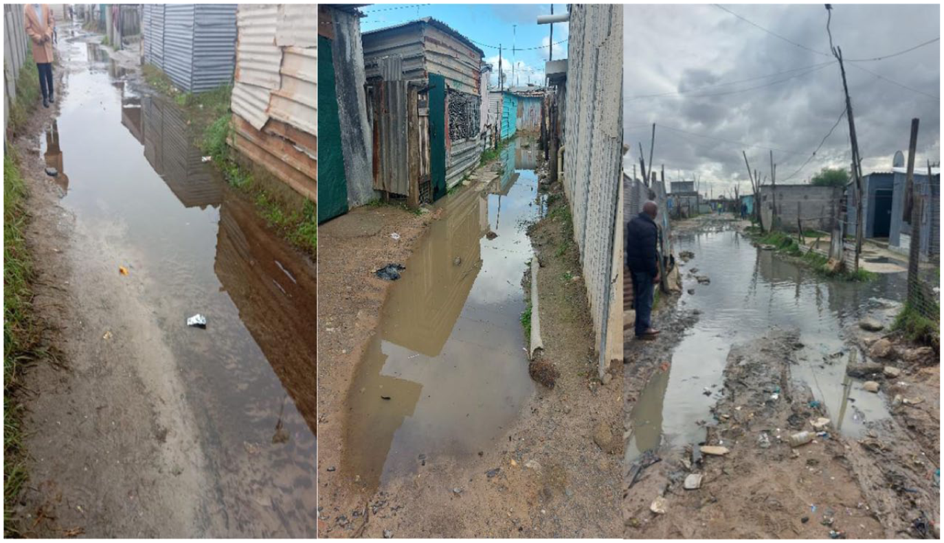
Urban flooding as a socio-spatial process in Cape Town informal settlements
These flood-risk patterns are especially evident in informal settlements, where they are co-produced through a combination of unregulated land development, insufficient investment in stormwater infrastructure, and the political neglect of low-income urban residents.(24) The absence of basic drainage systems, coupled with poor housing construction and a lack of waste management, turns rainfall into disaster. Moreover, flood risks are often exacerbated by top-down adaptation responses that displace residents or prioritize green infrastructure in wealthier neighbourhoods while ignoring informal zones.(25)
The built environment of informal settlements is often the result of adaptive improvisation rather than planning failure.(26) Residents build elevated homes, dig informal canals and construct physical barriers in attempts to mitigate flooding. These autonomous practices, illustrating not just vulnerability but also agency, remain unrecognized or criminalized by formal planning authorities. Corburn, in his 2022 study of informal settlements in Nairobi, demonstrates how citizen science and community-led data collection challenged the narrative that informal settlements are chaotic or unmanageable.(27) Instead, local residents mapped their own risks, tracked health and infrastructure gaps, and co-developed adaptation strategies with planners. This participatory process reframed flooding not as a technical problem of drainage, but as a social justice issue of infrastructure apartheid, where planning decisions over decades have shaped who drowns and who drains.
III. Conceptual Foundations: Justice in the Age of Adaptation
The primary focus of climate justice debates has shifted from global concerns about responsibility for emissions and vulnerability to impacts towards the everyday, lived dimensions of injustice in places such as urban informal settlements. Here, it becomes crucial to examine how adaptation’s burdens and benefits are distributed, how decisions are made, and whose voices and knowledges are recognized in governing climate risk.(28) Schlosberg’s (2003) three-part typology of distributive, procedural and recognitional justice is useful here. Distributive justice asks who receives flood defences and who is left unprotected in risk-prone zones; procedural justice interrogates the transparency and inclusiveness of decision-making; and recognitional justice demands respect for the identities, values and epistemologies of marginalized groups, including informal settlers, women, migrants, Indigenous peoples and the poor.(29) Empirical work in Indian cities shows how failures of recognition make migrants and informal workers simultaneously invisible in plans and hyper-visible as targets of removal, turning non-recognition into a precursor to dispossession.(30) Building on these insights, scholars call for transformative urban adaptation that embeds justice in outcomes and in the production of knowledge and policy, while confronting colonial spatial legacies, bureaucratic fragmentation and epistemic divides between communities and the state.(31) Without addressing such structural inequities, adaptation runs the risk of becoming a technocratic project that sustains resilience for some while displacing others, rather than a normative endeavour that must be evaluated against principles of justice, inclusion and accountability.(32)
A focus on spatial justice extends this agenda by bringing attention to how urban space is produced, ordered and contested, and how this shapes the geography of vulnerability and resilience. For Soja, spatial justice concerns not only the equitable distribution of land, housing, services, infrastructure and environmental protection, but also the recognition of space as an active medium of power through which structural injustices are reproduced. Urban flooding thus reflects zoning decisions, eviction practices and infrastructural allocations that privilege some spaces over others.(33) Schwab frames informality as a site of spatial injustice where residents are denied the right to shape urban space and highlights multiple dimensions that matter for justice: the quality of physical space, who plans and decides, how space is regulated and used, and whether marginalized place-making practices are recognized.(34)
Empirical work in South Africa shows how exclusionary planning and service gaps turn locations such as Kosmos(35) into landscapes of compounded risks (flooding, disease, poor mobility, inadequate sanitation), which can be better understood as spatial violence rather than mere development failure.(36) From a spatial justice perspective, adaptation must therefore move beyond retrofitting risky spaces towards reimagining urban space as a terrain for justice-making, where informal residents’ spatial claims and risk knowledges are acknowledged and infrastructural investment is used to repair, rather than entrench, past harm.(37) The paper’s conceptual framework (Figure 2) captures these ideas by showing how the core principles of redistribution, recognition, participation and transformation guide policy and institutional action across macro (national/policy), meso (municipal/institutional) and micro (community/grassroots) levels, linked through co-governance processes of dialogue and power-sharing that are essential for equitable flood adaptation in marginalized urban settlements.(38)
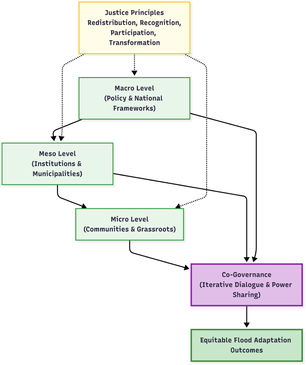
Integrated governance–justice model for equitable flood adaptation in informal settlements: conceptual framework
IV. Methodology
a. Mapping justice across waters and walls
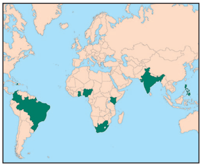
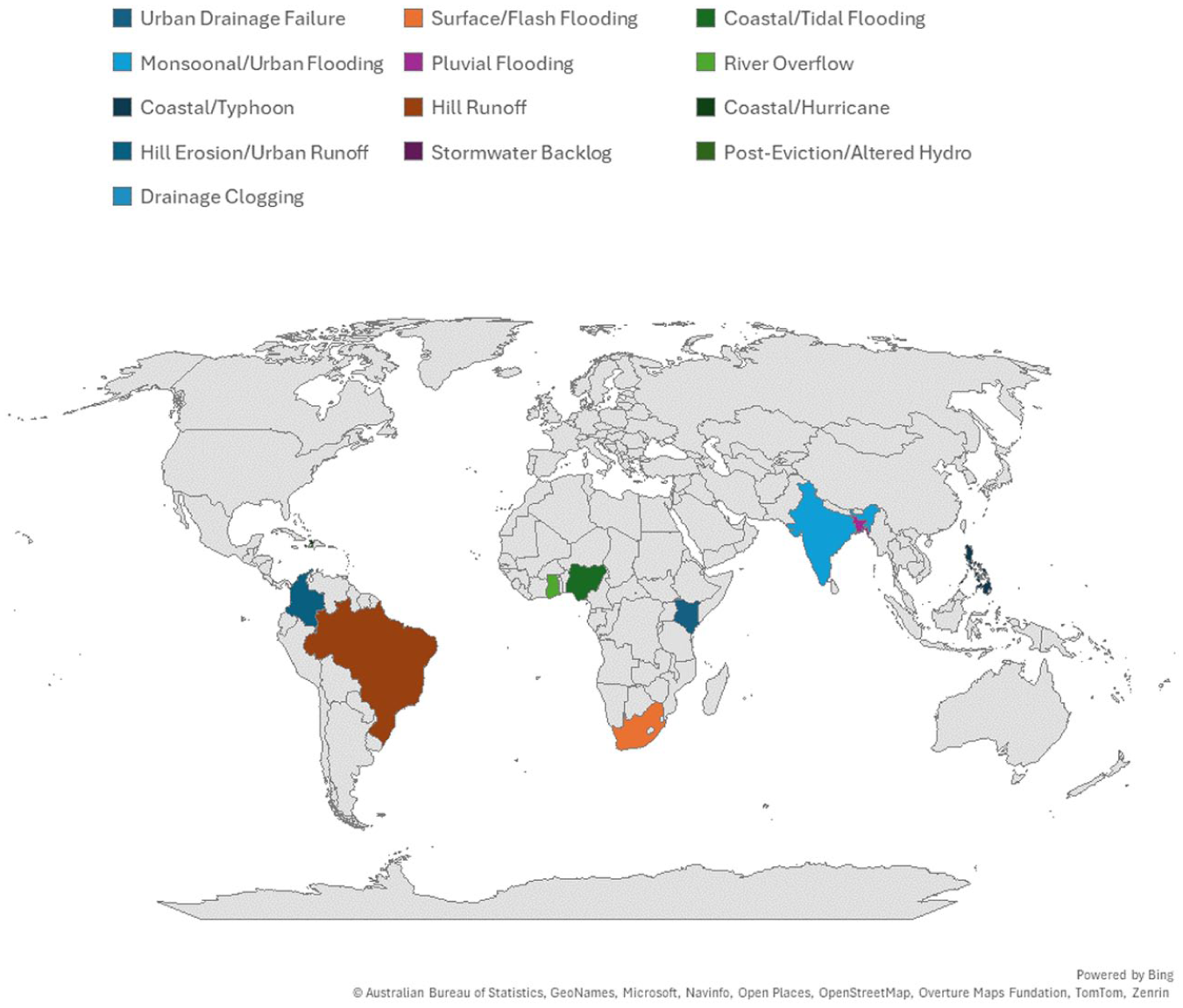
This study employs a qualitative, document-based, comparative research design to investigate how justice – particularly its spatial, procedural, recognitional and distributive dimensions – is embedded, omitted or contested in flood adaptation practices across informal settlements in the global South. Thirteen informal settlements were selected across Africa, Latin America, South Asia and Southeast Asia using purposive, theoretically informed sampling. The selection followed a sequential process. First, a scoping review was conducted of academic and grey literature on urban flooding, climate adaptation and justice in informal settlements, using keyword searches in databases such as Scopus and Web of Science, as well as Google Scholar and institutional repositories. Search strings combined terms such as “urban flooding”, “informal settlement”, “slum”, “favela”, “adaptation”, “upgrading”, “justice” and “climate risk” and were refined iteratively through citation tracking and snowballing. Second, from this longlist of cases, a sampling frame was developed of settlements that met four criteria: (1) geographical diversity and differing flood-risk profiles (coastal, riverine, pluvial, hillside); (2) variation in institutional responses, from eviction to in situ upgrading; (3) availability of rich documentation in both academic and grey literature; and (4) inclusion of both “iconic” cases (for example, Dharavi, Kibera) and relatively under-studied sites, to balance depth with breadth.
The final set of cases (Figure 3) includes Mukuru and Kibera (Nairobi, Kenya), Khayelitsha(39) and Joe Slovo(40) (Cape Town, South Africa), Makoko (Lagos, Nigeria), Dharavi (Mumbai, India), Korail (Dhaka, Bangladesh), Old Fadama (Accra, Ghana), Baseco (Manila, Philippines), Rocinha and Vila Autódromo (Rio de Janeiro, Brazil), Cité Soleil (Port-au-Prince, Haiti) and Altos de Cazucá (Bogotá, Colombia).(41)
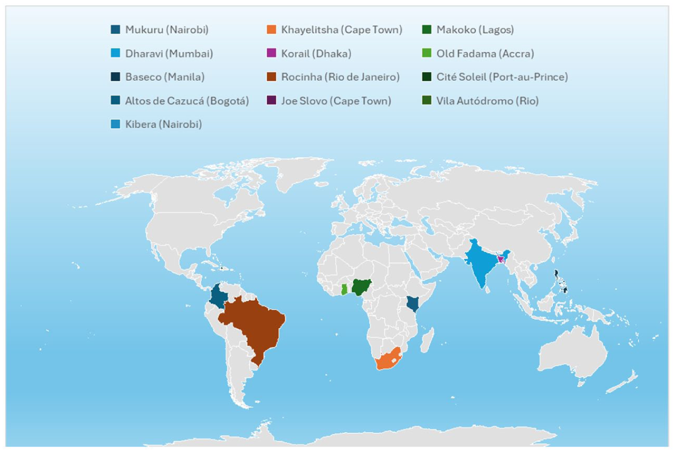
Global distribution of informal settlements included in the study
Key policy and planning documents were then traced (such as municipal adaptation plans, upgrading frameworks, infrastructure masterplans) through municipal websites, national government portals and references contained in the academic literature. Grey literature produced by non-governmental organizations (NGOs), social movements and international organizations (for example, Shack/Slum Dwellers International – SDI, UN-Habitat, World Bank and local civic groups) were identified via organizational websites and were cross-referenced with academic sources to verify credibility and avoid uncorroborated claims. Citation snowballing and backward–forward reference tracking was used throughout to minimize the risk of overlooking influential documents. While not exhaustive, this process generated a sufficiently rich corpus to enable comparative, justice-oriented analysis across the 13 settlements.
b. Analytical framework and coding strategy
The analysis employed a hybrid coding approach combining deductive and inductive techniques. Initial codes were derived from the Justice-Oriented Flood Adaptation Framework (JOFFA) (see Section VI), encompassing: distributive justice (for example, infrastructure allocation, service delivery gaps); procedural justice (for example, participation mechanisms, consultation quality); recognitional justice (for example, inclusion of community knowledge, identity politics); spatial justice (for example, patterns of relocation, zoning exclusions); and transformative potential (for example, institutional reform, co-governance structures). Coding was conducted using qualitative data analysis software (NVivo), enabling the comparison of justice dimensions across cases, tracking dominant themes, silences, contradictions and emerging framings. A cross-case matrix was constructed to identify patterns of inclusion, exclusion and contestation within and between settlement contexts.
V. Findings
a. Summary of case studies: flooding and justice across informal settlements
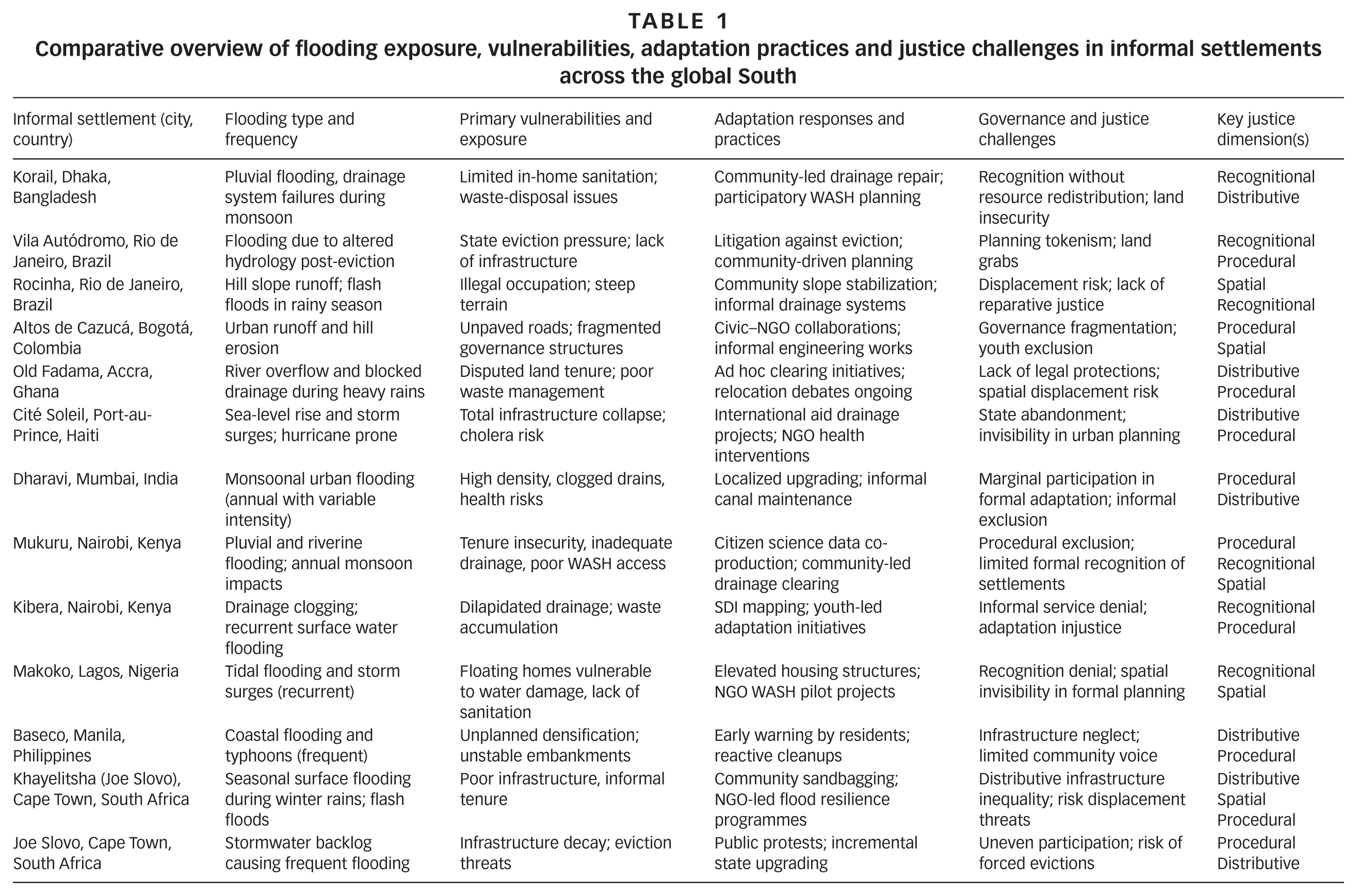
This comparison of 13 informal settlements across Africa, Asia and Latin America shows how urban flooding is shaped as much by social and spatial injustice as by hydrometeorological hazards. From riverine slums such as Mukuru and Kibera, to coastal Makoko, to hillside favelas in Rio de Janeiro and monsoon-prone settlements in Mumbai and Dhaka, flood risks emerge through intense rainfall, tidal surges, river overflow and failing drainage, compounded by rapid urbanization and environmental degradation. Across all cases, structural vulnerabilities – insecure tenure, infrastructural neglect, exclusion from formal services and socio-political invisibility – deepen overall flood risk and intensify social and health impacts. Adaptation responses form a patchwork: some settlements gain from community-led data gathering and participatory planning, while others face evictions and investments skewed towards wealthier neighbourhoods, revealing entrenched infrastructures of exclusion and highly stratified resilience (Table 1).
Comparative overview of flooding exposure, vulnerabilities, adaptation practices and justice challenges in informal settlements across the global South
b. Distributions of risk and response
A striking pattern emerging across all 13 informal settlements studied is the unequal and often inequitable distribution of essential flood adaptation resources, notably drainage infrastructure, WASH facilities and formal flood protection systems. This disparity manifests in what can be described as patching the city unevenly, a process whereby affluent or formally recognized neighbourhoods benefit from consistent flood-mitigation investments, while informal settlements remain chronically underserved and exposed to recurrent inundation.(42) Figure 4 maps the dominant flooding typologies affecting the 13 informal settlements included in this study, ranging from urban drainage failure, monsoonal and pluvial flooding, surface/flash flooding and drainage clogging to coastal/tidal and hurricane-driven events, river overflow, hill runoff and erosion, stormwater backlog and post-eviction/altered hydrology conditions.(43)
Flooding typologies in informal settlements: spatial distribution of flooding types
In Nairobi’s Mukuru and Kibera settlements, despite high flood exposure and extensive citizen-led documentation of risk, investments in stormwater drainage and sanitation have lagged significantly behind those in adjacent middle-class suburbs.(44) This spatial disparity results in a disproportionate burden on residents who endure both health risks from contaminated floodwaters and economic losses from disrupted livelihoods. Similarly, in Cape Town’s Khayelitsha and Joe Slovo informal settlements, residents face repeated flooding due to failing informal drainage channels and limited municipal upgrades, whereas nearby formalized areas are equipped with engineered stormwater systems.(45)
In South Asia, both Dharavi in Mumbai and Korail in Dhaka experience monsoonal floods aggravated by clogged drains and lack of formal WASH services, yet government adaptation efforts have historically favoured commercial or formal urban centres.(46) Informal residents rely heavily on self-constructed coping mechanisms, such as elevated homes or informal canal clearing, further highlighting gaps in state-supported resilience.
The Brazilian favelas of Rocinha and Vila Autódromo also exemplify uneven adaptation landscapes. While some community-driven slope-stabilization and drainage projects exist, these efforts pale in comparison to the flood protection infrastructure provided to wealthier neighbourhoods, expressing the unequal urban environmentalism that characterizes Rio’s socio-spatial fabric.(47)
This uneven patchwork of adaptation infrastructure is neither accidental nor simply a product of resource constraints. It reflects entrenched sociopolitical priorities that value certain urban lives and spaces over others, with informal settlements frequently cast as expendable risk zones rather than sites of investment. The resulting spatial injustices exacerbate flooding impacts and reduce the effectiveness of adaptation across the urban system as a whole.
c. Exclusion by design: planning, policy and spatial marginalization
A second critical finding concerns the systematic exclusion of informal settlements from formal adaptation planning and policy frameworks, a phenomenon aptly captured by the concept of planning by omission.(48) This occurs when adaptation strategies, land-use plans and municipal risk assessments neglect to explicitly recognize or engage informal settlements, effectively erasing them from governance and investment agendas.
In Cape Town, for instance, the city’s Integrated Development Plans and climate adaptation policies frequently overlook informal settlements such as Khayelitsha or Joe Slovo in their stormwater and flood-risk management sections.(49) Such omissions translate into tangible neglect, where municipal budgets for infrastructure bypass informal areas and formal risk-communication systems do not adequately serve these communities.
Nairobi’s adaptation plans prior to the Mukuru Special Planning Area (SPA) initiative(50) similarly marginalized informal settlements by framing them as informal hazards rather than legitimate urban spaces worthy of inclusion.(51) It was only through concerted community–citizen science partnerships that Mukuru was brought onto formal planning maps, illustrating how state documents tend to exclude informal voices unless this is actively contested.
The Indian city of Mumbai exhibits a comparable dynamic. Despite Dharavi’s economic significance and vulnerability to monsoon floods, municipal climate-resilience plans historically neglected the settlement, focusing adaptation investments on formal commercial districts and affluent residential areas.(52) This omission undergirds ongoing cycles of vulnerability, where flood risk is both spatially and socially reproduced.
Brazilian cities such as Rio de Janeiro reveal how planning by omission is compounded by deliberate eviction and clearance policies masquerading as adaptation measures. Vila Autódromo’s forced evictions, justified on flood-risk grounds, illustrate how exclusion is embedded not only in silence but also in coercive spatial governance practices.(53) The state’s selective recognition thus acts as a powerful mechanism to marginalize informal residents in the name of resilience.
Together, these cases reveal that planning by omission is a key governance mechanism that reproduces spatial marginalization in flood adaptation. The failure to integrate informal settlements into official risk frameworks denies these communities access to resources, information and political voice, effectively rendering them invisible in the cities’ climate futures.(54)
d. Partial participation: co-option or co-production?
Procedural justice, the fairness and inclusivity of decision-making processes, is foundational to equitable flood adaptation. However, across the studied cases, participation varies widely in scope, depth and genuine influence. Rather than a binary of participation versus exclusion, what emerges is a spectrum of partial participation, where community involvement is sometimes co-opted, tokenized or constrained by institutional logics rather than being genuinely empowering.
The Mukuru SPA in Nairobi stands out as a seminal exemplar of citizen-led adaptation and co-production. Here, local residents collaborated directly with municipal authorities, NGOs and academic partners in a deliberative and iterative process to map flood risks, co-design drainage infrastructure and articulate community priorities.(55) This partnership embodied core principles of procedural justice: community knowledge was validated, residents had tangible influence over planning, and accountability mechanisms were embedded to ensure implementation responsiveness.
By contrast, many other settlements experience participation as co-option, where state-led adaptation initiatives invite community input only in controlled formats, such as public meetings or surveys, that lack substantive power-sharing.(56) In Cape Town’s Joe Slovo and Khayelitsha informal settlements, residents report limited consultation confined to information dissemination rather than decision-making, reflecting a participation paradox where communities are engaged to legitimize predetermined plans without having meaningful influence.(57)
In Mumbai’s Dharavi and Dhaka’s Korail, community groups have organized informal forums and NGO-facilitated dialogues to voice concerns over flooding and WASH access. However, state adaptation frameworks often marginalize these efforts, co-opting them as compliance mechanisms rather than partnerships in governance.(58) These dynamics reveal how procedural justice is frequently compromised by power asymmetries, bureaucratic inertia and competing political agendas.
Similarly, in Rio de Janeiro’s favelas, participation in adaptation projects tends to be fragmented and mediated through elite community brokers, raising questions about representativeness and empowerment.(59) The risk of co-option is high where participatory spaces are controlled by powerful intermediaries who may prioritize their interests over those of marginalized residents. This cross-case analysis suggests that procedural justice in flood adaptation is often partial, ambivalent and contested. A recurring cross-cutting issue is that meaningful co-production is not only a question of political will but also of capacity. While communities in Mukuru, Dharavi, Kibera and Joe Slovo possess dense experiential knowledge and long-standing organizational skills, they often lack stable resources, technical equipment or institutional backing to sustain citizen science and participatory planning on their own. Conversely, municipal officials, universities and NGOs may have technical expertise yet lack the competencies to engage informal residents as equal partners rather than data providers. The Mukuru SPA illustrates the crucial enabling role played by intermediary organizations and universities, training local enumerators, providing tools for mapping and data analysis, and supporting community leaders to navigate bureaucratic procedures.(60) Where such enabling capacities are absent, participatory mechanisms risk becoming extractive or symbolic, reinforcing the very injustices they are meant to undo.
e. Epistemic silencing: whose knowledge is counted?
Closely linked to procedural justice is the question of recognitional justice, specifically regarding whose knowledge and experiences are acknowledged and valued in adaptation governance. Across all cases, there is a pervasive pattern of epistemic silencing, the systematic marginalization of local, indigenous and experiential knowledge in favour of expert-driven, technical and quantitative understandings of flood risk.(61) Indeed, climate adaptation too often listens in the wrong language – that is the dilemma. Adaptation frameworks are dominated by scientific risk models, geographic information system (GIS)-based flood maps and engineering solutions, which frequently fail to capture the lived realities, adaptive capacities and social complexities of informal settlements.(62)
For instance, in Mukuru’s SPA, the integration of citizen science – with residents collecting flood data and mapping infrastructure deficits – enabled a more grounded and nuanced understanding of risk.(63) This bottom-up knowledge challenged official narratives and created new epistemic spaces for community-driven solutions. Similarly, participatory mapping in Kibera and Dharavi revealed localized drainage patterns, seasonal flood impacts and coping strategies that were previously invisible to planners.(64)
In Latin America, favelas such as Rocinha and Vila Autódromo have documented similar struggles. Community knowledge about hillside runoff, informal drainage channels and displacement risks is routinely discounted or overridden by state actors, who privilege technical expertise and formal land-use plans.(65) Such dynamics produce what scholars call epistemic injustice, which denies marginalized groups the authority to define and address their own risks.(66)
The result is a knowledge hierarchy that privileges universalizing scientific discourses over plural, situated knowledges, perpetuating exclusion and limiting the effectiveness and equity of adaptation interventions. Addressing this requires epistemic pluralism, embracing diverse ways of knowing and fostering co-learning spaces between communities, scientists and policymakers.
f. Climate citizenship and spatial claim-making
In the face of increasing flood risks and state-led eviction pressures, many informal settlement communities have moved beyond survival tactics to engage in assertive spatial claim-making, enacting what can be termed “climate citizenship”. This concept reflects residents’ active efforts to assert their right to remain in place, to adapt in situ and to participate in shaping climate-resilient futures, rather than being displaced or erased under the guise of flood mitigation.(67) This form of territorializing justice through adaptive resistance reframes adaptation as a political act that intertwines identity, belonging and rights claims with everyday practices of environmental management and advocacy. Communities transform their neighbourhoods into sites of contestation where the right to the city is actively negotiated against forces of exclusion, displacement and infrastructural neglect.
In Nairobi’s Mukuru, grassroots groups have mobilized around participatory flood-risk mapping and co-production of adaptation plans as a means to secure recognition and legitimize their spatial presence.(68) These efforts not only facilitate improved infrastructure but also symbolize a collective claim to urban citizenship, asserting that informal settlements are integral, not peripheral, to the city’s socio-environmental fabric. Similarly, in Cape Town’s Joe Slovo and Khayelitsha, residents have organized sustained campaigns combining legal action, public protest and participatory planning forums to resist forced evictions linked to flood risk and urban redevelopment. Through these actions, communities insist on their right to remain in flood-prone areas equipped with appropriate protections, challenging narratives that frame informal dwellers as liabilities rather than rights-bearing urban actors.
Mumbai’s Dharavi offers another powerful example of climate citizenship in practice. Despite persistent official threats of clearance to respond to monsoonal flooding and urban renewal projects, community-based organizations have leveraged local knowledge and advocacy to negotiate for in situ upgrading and improved flood-resilience measures.(69) These negotiations embody a spatial claim-making process that intertwines environmental adaptation with social justice and tenure security. In Latin America, particularly in Rio de Janeiro’s favelas, spatial claim-making often unfolds through social movements that link flood adaptation to broader struggles for land rights and urban inclusion.(70) The Vila Autódromo community’s resistance to eviction and displacement in the face of flood-related urban redevelopment epitomizes this nexus of climate justice and urban citizenship. Through collective mobilization, legal challenges and alliances with NGOs, residents articulate their spatial and political right to the city, demanding adaptation policies that do not come at the cost of dispossession.
Theorists such as Holston and Roy have emphasized that such insurgent citizenship challenges the state’s monopoly over urban space, creating new forms of spatial justice through everyday acts of claiming, defending and remaking place.(71) Climate citizenship extends this insight by highlighting how climate risk and adaptation become focal points for demanding recognition, participation and equity. However, these spatial claims are often met with resistance by urban authorities, who frame informal settlements as illegal, hazardous or ungovernable.(72) The politics of climate citizenship thus involve ongoing negotiation and contestation over whose knowledge counts, whose presence is legitimate and whose futures are prioritized in the face of environmental change.
Thus, climate citizenship and spatial claim-making represent critical dimensions of adaptation from below, through which flood-affected communities not only survive but also actively reconfigure the social and political geographies of their cities. These processes are central to territorializing justice: embedding claims for recognition, rights and resources in the very places where vulnerability and resilience converge.
VI. Justice-Oriented Framework for Flood Adaptation (JOFFA)
In light of the contested, uneven and often exclusionary flood-adaptation dynamics observed across informal settlements, this paper proposes a novel analytical and operational framework, the Justice-Oriented Framework for Flood Adaptation (JOFFA). JOFFA (Figure 5) is designed to guide scholars, practitioners and policymakers towards embedding justice at the core of flood-resilience efforts, moving beyond technocratic fixes towards transformative, inclusive and spatially equitable adaptation.
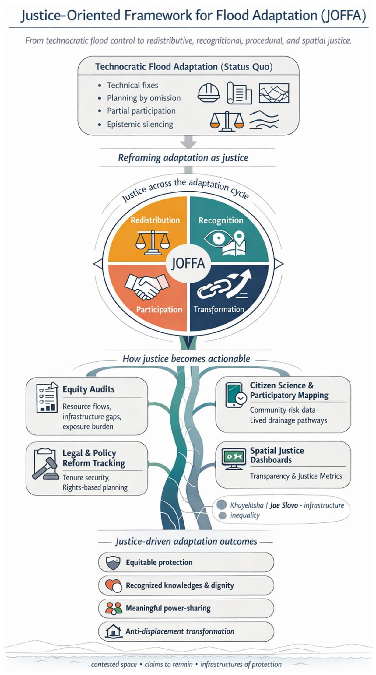
Justice-Oriented Framework for Flood Adaptation (JOFFA) – a vertical river-spine model
a. Normative principles: planning for justice
The foundation of JOFFA (Table 2) consists of four interrelated normative principles that collectively define justice-centred flood adaptation: redistribution, recognition, participation and transformation:
Normative foundations of the Justice-Oriented Framework for Flood Adaptation (JOFFA)
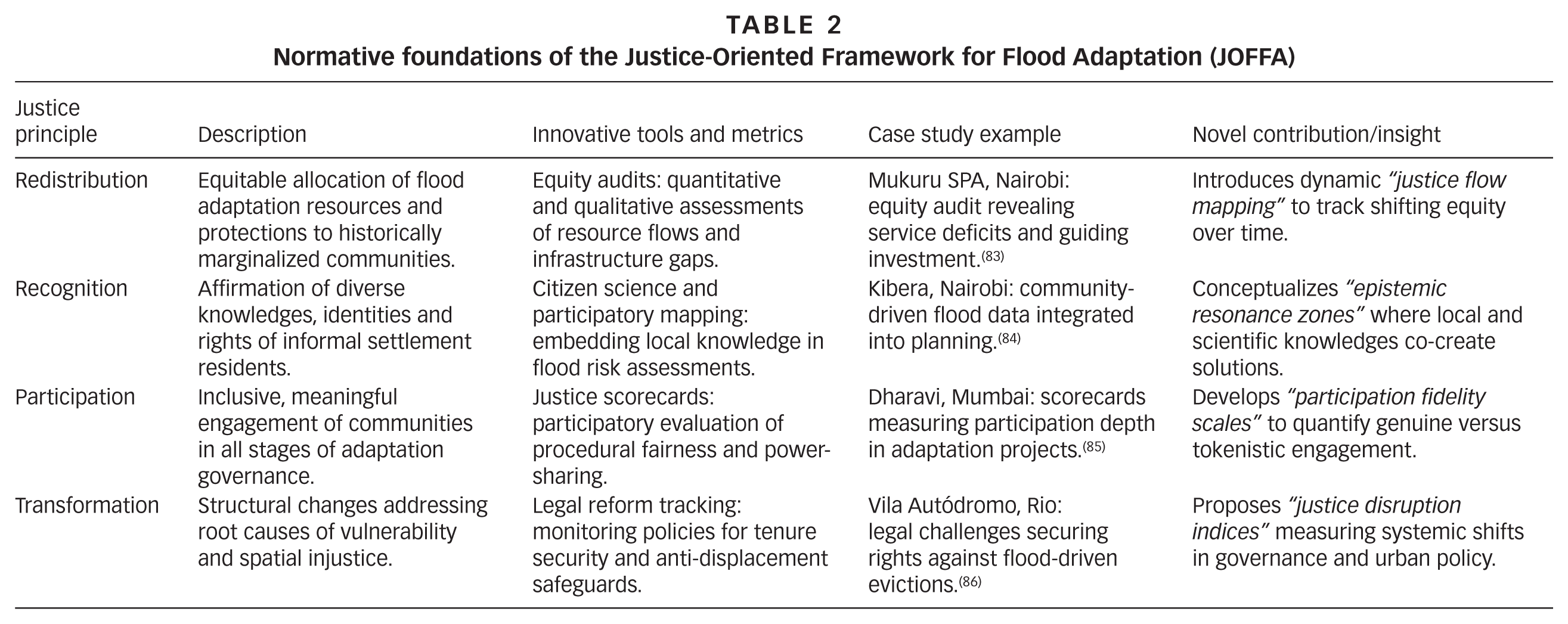
As Table 2 indicates, each justice principle and operational tool is grounded in concrete experiences from the 13 informal settlements analysed in this paper. For practitioners, this opens up practical South–South learning pathways rather than a generic checklist: equity audits in Mukuru, for example, offer transferable methods for identifying infrastructure gaps in Korail or Khayelitsha; citizen science and participatory mapping in Kibera and Dharavi provide templates for recognizing local knowledge in Cité Soleil or Old Fadama; and legal struggles in Vila Autódromo and Joe Slovo illustrate how transformative adaptation can be coupled with anti-eviction and tenure security agendas. JOFFA is therefore not an abstract framework, but a synthesis of justice-oriented practices already emerging across the urban global South that can travel and be adapted and iteratively improved.
b. Operational domains
Translating normative justice principles into practice requires operational tools, each of them related to specific operational domains,(87) through which adaptation processes can be assessed, monitored and co-produced. JOFFA distinguishes between operational domains and operational tools. Operational domains are the broad areas of practice in which justice must be embedded (for example, how risks are diagnosed, how knowledge is produced, how decisions are made and how outcomes are monitored). Within each domain, a set of concrete tools – such as equity audits, citizen science, justice scorecards(88) or spatial dashboards – can be used to make justice principles visible and actionable. In other words, the domains answer where in the adaptation cycle justice is operationalized, while the tools specify how this is done in practice. JOFFA identifies four core operational domains vital for justice-oriented flood adaptation:
These operational domains function synergistically within JOFFA, allowing adaptation efforts to be continuously evaluated and recalibrated against justice benchmarks. Importantly, they emphasize the agency of informal communities as active participants and knowledge producers, while holding state and non-state actors accountable for equitable flood resilience.
Figure 6 illustrates the JOFFA framework, depicting how four core justice principles – redistribution, recognition, participation and transformation – connect to specific operational domains (equity audits, citizen science and participatory mapping, legal and policy reform, and spatial justice dashboards). The tools in the operational domains facilitate measurable adaptation outcomes including equitable resource allocation, inclusion of marginalized voices, empowered community participation and systemic socio-spatial transformation. The framework highlights the integrated pathway through which justice-centred flood adaptation can be realized in informal settlements, promoting inclusive, equitable and transformative urban resilience.
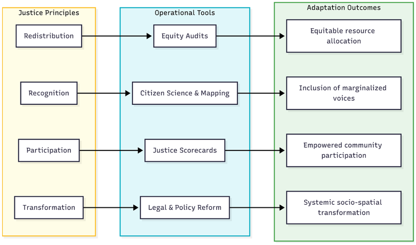
Justice-Oriented Framework for Flood Adaptation (JOFFA): linking principles, operational tools and adaptation outcomes
c. Capacity, enabling conditions and practical steps for justice-oriented co-production
JOFFA assumes that justice-oriented co-production depends on building capacities across all actors. Residents of informal settlements bring deep experiential knowledge and strong associational life to the table. Partners from universities, NGOs and municipal departments bring more technical knowledge to the effort, but must develop skills in facilitation, conflict mediation, data sharing and translating between technical and vernacular languages, supported by long-term, well-resourced partnerships rather than short project cycles. In practice, the framework functions as an iterative toolkit: a multistakeholder working group in a given settlement conducts equity audits and participatory mapping to jointly diagnose exposure and infrastructure gaps; co-designs adaptation options using justice scorecards to compare their redistributive effects and degree of community control; and then institutionalizes the agreed package through budgets, planning instruments and community–municipal monitoring committees that maintain spatial justice dashboards over time. Capacity-building and resourcing of community organizations are treated as cross-cutting enabling conditions: without them, citizen science and co-production may remain rhetorical rather than genuinely embedding justice into everyday decisions about urban flood risk.
VII. Conclusion: Towards Equitable Urban Futures amid Rising Waters
This paper argues that as climate change intensifies urban flooding, effective adaptation in informal settlements must go beyond technical fixes to confront the entrenched social, spatial and environmental injustices that produce vulnerability. Informal settlements are frontline sites where marginalization, infrastructural neglect and exclusion from urban decision-making converge, meaning that adaptation must simultaneously reduce hazard exposure and dismantle inequities in governance, land tenure and resource distribution. Justice-driven adaptation from below is central to this vision: through grassroots infrastructures of survival, intermediary brokers of justice and claims to climate citizenship, residents assert their right to remain, adapt and co-create resilient futures. The Justice-Oriented Framework for Flood Adaptation (JOFFA) offers a normative compass and practical toolkit to support such efforts, insisting that adaptation be participatory, redistributive, recognitional and explicitly guided by questions of who is protected, how, by whom and according to which values.
The paper calls for a deep transformation of planning and governance from top-down control to co-authored, justice-centred co-governance, where communities, municipalities, NGOs and intermediaries share power, knowledge and responsibility. Addressing flood risk in the urban global South thus requires transformative justice that reconfigures the social and spatial relations underpinning vulnerability, so that rising waters catalyze resilient, inclusive and just cities rather than deepen exclusion. Future research should move from document-based analysis to collaborative, action-oriented work that tests and refines JOFFA in practice, through participatory and ethnographic engagement in places such as Mukuru, Khayelitsha/Joe Slovo, Dharavi or Vila Autódromo and across multi-hazard contexts such as heatwaves and droughts. Longitudinal, transdisciplinary research of this kind can illuminate how justice-oriented tools work across political and institutional settings, and what enabling conditions, capacities and alliances are required to make justice-driven flood adaptation durable in everyday urban governance.
Footnotes
Acknowledgements
I acknowledge the community organizations, residents and practitioner networks whose documented experiences and advocacy inform the case insights synthesized in this paper. I also thank colleagues at the African Climate and Development Initiative (ACDI), University of Cape Town, for constructive feedback on earlier drafts.
Declaration of Conflicting Interests
The author declared no potential conflicts of interest with respect to the research, authorship, and/or publication of this article.
Funding
The author received no financial support for the research, authorship, and/or publication of this article.
Disclaimer
Liability for commissions, omissions and/or views expressed in this paper remains entirely the responsibility of the author.
Data Availability (Data Transparency)
The paper does not have any data to declare.
1.
Similar stories unfold in Khayelitsha, Cape Town, where winter downpours fill sandbag-lined trenches and bucket toilets in backyards of formal–informal hybrid settlements, spaces simultaneously governed and abandoned. The same scenarios are visible in Mumbai’s Dharavi, where monsoon rains overload improvised drains and turn live–work alleys into polluted canals; and in Rio de Janeiro’s hillside favelas such as Rocinha, where storm run-off tears through precarious stairways and self-built homes that remain peripheral in official visions of a resilient city.
2.
Rough neighbourhoods are urban communities where multiple forms of hardship (precarious housing, infrastructural neglect, environmental hazards, everyday violence and insecure livelihoods) intersect and persist over time, producing chronic conditions of exposure and marginalization.
6.
Udo et al. (2025). Some examples: in South Africa, apartheid-era spatial planning forcibly displaced Black and Coloured populations to peripheral flood-prone zones with little access to formal infrastructure (Turok and Visagie 2018). These patterns endure: informal settlements such as Khayelitsha experience chronic flooding, yet receive delayed or insufficient stormwater interventions, compared with adjacent formal suburbs (Ziervogel et al. 2016). Similarly, in Nairobi, state-led infrastructure investment has historically bypassed low-income zones such as Kibera and Mukuru, even as these areas absorb disproportionate flood damage (![]() ).
).
9.
11.
13.
Fisher (2015); Kelman et al. (2015). Also, by focusing explicitly on flood adaptation, there is a risk of foreclosing on the broader multihazard realities of informal settlements, where floods intersect with heatwaves, droughts, landslides, fires, food insecurity and health emergencies in complex cascades. See Taylor et al. (2020); Pelling et al. (2022); Šakić Trogrlić et al. (2024); ![]() .
.
15.
16.
18.
20.
Fraser (2017). In Nairobi’s Mukuru settlement, for example, fewer than 1per cent of residents had access to in-home toilets, and over 40per cent reported regular flooding conditions that not only increase disease risk but also underline their exclusion from state infrastructure networks. See Ngunjiri (2022); ![]() .
.
28.
30.
Chu and Michael (2019).
35.
Kosmos informal settlement is located in Madibeng Local Municipality, Bojanala District, North West Province, South Africa, on the western shore of the Hartbeespoort Dam, adjacent to the upmarket village of Kosmos. It has been documented as a site of severe environmental and infrastructural injustice, including inadequate sanitation, waste management and basic services (![]() ).
).
37.
39.
Khayelitsha is a large township on the Cape Flats in Cape Town, South Africa. Established during late apartheid, it comprises multiple formal and informal sections and is one of the city’s most flood-exposed urban areas, with recurrent winter inundation and chronic service backlogs.
40.
Joe Slovo is a distinct informal settlement in Cape Town, located along the N2 corridor near Langa, and is treated in this paper as a separate case from Khayelitsha. It has its own history of flooding, upgrading initiatives and high-profile anti-eviction struggles, which justify analysing it separately from other Cape Flats settlements.
41.
These sites are not statistically representative; rather, they are strategic cases that enable comparative insight into the politics of flood adaptation and justice under different governance contexts, planning legacies and civic mobilizations.
42.
43.
This flood typology refers to flood risks that emerge or worsen after large-scale evictions, demolition, land filling or re-engineering of urban space, which disrupt existing drainage paths and local hydrology. When settlements are cleared or reshaped for mega-projects or green infrastructure, surfaces are regraded, vegetation removed and new barriers constructed, often redirecting runoff into remaining low-income areas and creating new pockets of flooding that did not previously exist.
50.
The Mukuru SPA refers to a locally led, inclusive and multisectoral upgrading of Mukuru’s informal settlements for climate resilience, one of the largest upgrading projects ever undertaken. The area is home to about 400,000 residents.
51.
52.
54.
55.
60.
Corburn et al. (2022); ![]() . These actors operate as intermediary justice brokers, sitting between state institutions and informal residents, translating between technical and vernacular languages, helping communities frame their claims in rights-based and policy terms, and keeping questions of equity, recognition and anti-eviction safeguards on the agenda of ostensibly technical adaptation processes.
. These actors operate as intermediary justice brokers, sitting between state institutions and informal residents, translating between technical and vernacular languages, helping communities frame their claims in rights-based and policy terms, and keeping questions of equity, recognition and anti-eviction safeguards on the agenda of ostensibly technical adaptation processes.
63.
64.
71.
87.
JOFFA conceptualizes equity audits, citizen science and participatory mapping, legal and policy reform, and spatial justice dashboards as four interlinked operational domains rather than as isolated instruments. Operational domains are the key arenas in which justice principles are embedded in practice. Each domain can be operationalized through a family of concrete tools and techniques (for example, different audit methods, mapping approaches, legal mechanisms or dashboard indicators), which can be adapted to specific contexts. Put differently, the domains indicate where justice work is located within the adaptation process, while the specific methods, metrics and platforms used within each domain represent how this work is carried out in practice.
88.
Justice scorecards are simple, participatory tools for rating how “just” a specific adaptation project or option is. Communities, officials and intermediaries agree on a small set of indicators under each principle (redistribution, recognition, participation, transformation) and then score each option (for example, low/medium/high) with short notes. The resulting scorecards give a concise, comparable snapshot of where an intervention advances justice, where it falls short, and where redesign or additional safeguards are needed.