
Abstract
Recent research on climate vulnerability in cities in the Amazon Delta and Estuary (ADE) shows that about 1.2 million people are at risk of flooding due to the rapid unplanned occupation of lowlands and the absence of investment in infrastructure and services. In this study, we use secondary climate and census data, interviews and focus groups in four small cities in the Amazon Delta and Estuary (SCADEs), to discuss how residents and local governments perceive and respond to climate hazards and their implications. These SCADEs may be better equipped than other urban areas to deal with challenges brought by climate change, due partially to residents’ high mobility between urban and rural areas and a tradition of adaptive actions in a dynamic social and environmental context. However, persistent flooding and sinkholes demonstrate the limited capacity of local governments to cope with the dynamics of accelerated occupation of floodplain areas in SCADEs.
Keywords
I. Introduction
Climate change studies in the Amazon have been largely focused on the monitoring of biomass reduction and the regional climate.(1) Only more recently has attention been given to interactions among anthropogenic activities, such as deforestation and urbanization, and climate change variables and hydroclimatic systems.(2) Moreover, there are very few studies focusing on vulnerability to climate change in Amazon Delta and Estuary (ADE) cities, despite the enormous scale of exposure to floods and other hydroclimatic hazards present in the region.(3)
About 1.2 million people are at risk of flooding during extreme water events in ADE urban areas, as a result of poverty, infrastructure and high-flood hazard – about 41 per cent of the total population living in the area, mostly those residing in unplanned settlements. More than half the population considered under risk (57 per cent) is located in the Metropolitan Region of Belém, and 26 per cent are in SCADEs (small cities in the Amazon Delta and Estuary).(4) Unplanned settlements in urban areas have been mapped only for large cities by the Brazilian Institute of Geography and Statistics (IBGE), and in the 2010 census, Belém was classified as the city with the highest proportion of households located in “subnormal settlements” (aglomerados subnormais) throughout the country (about 52.5 per cent of all households). IBGE defines a subnormal settlement as “a group of 51 or more housing units characterized by an absence of a property title and at least one of the following: irregularities in traffic routes, lot size and shape, and lack of basic public services (garbage collection, sewage system, water supply, energy and public lighting)”.(5)
In the Brazilian Amazon, including in ADE regions, from the 1970s onwards, there was an incentive to establish large enterprises, such as hydroelectric dams and steel industries, followed by the formation of industrial parks and roads, parallel with the expansion of the Southeast agricultural frontier.(6) Settlement of urban areas by rural migrants in these regions has tended to be concentrated in peripheral areas below sea level. Therefore, population growth, fuelled by the rapid expansion of unplanned urban occupation, has exacerbated the environmental threats of climate change, particularly for migrants living in informal settlements – often reinforcing inequalities and creating new pockets of poverty in urban areas.(7)
In contrast to the situation in large cities in the region, SCADEs appear to be more successful in reducing socioenvironmental vulnerability to floods and in shaping the process of climate adaptation in the Brazilian Amazon. There are indications that peri-urban and rural populations, faced with adverse or hazardous hydroclimatic events, increasingly rely on safety networks, resources and services offered in SCADEs for their economic relief. Moreover, there is intense mobility and trade in SCADEs, and multi-sited households are common, characterized by a frequent flow of people and goods between urban and rural spheres.(8) Evidence on the multiple current and potential roles of SCADEs in reducing hydroclimatic risks, particularly the diversity of knowledge and strategies used by residents, is relevant for sustainable development initiatives and for improving climate adaptation programmes.
Recent studies have shown that climate impacts and effective solutions are often locally specific, and evidence from representative case studies has been helpful in devising adaptation policy options. In addition, applied researchers have called for detailed investigations that identify the local causes of climate hazards and their relative contribution to impacts and implications for adaptation.(9) Delta studies have also demonstrated that the ways humans shape and interact with the physical conditions of rivers and deltas are key to understanding the environmental, social and economic impacts of climate hazards,(10) and that the formulation of policy options should be grounded in the local context. Policymaking is challenging in developing countries, where social and economic crises may limit long-term planning, potentially making climate change adaptation and mitigation a low priority on the political agenda.(11)
In this paper, we examine the challenges faced by stakeholders in four selected SCADEs. We analysed climate hazards using secondary data and investigated the perceptions of stakeholders. Urban practices, which may advance or alleviate climate risk exposure and related adaptation strategies, were also discussed with stakeholders. Three main goals have guided this research:
1) to analyse longitudinal climate data for the Amazon Delta under a vulnerability framework for urban resilience (detailed below)
2) to identify, along with local stakeholders, the most important urban hazards produced by climate change in SCADEs
3) to advance the understanding of challenges and opportunities for adaptive urban planning for SCADEs
II. The Climate Vulnerability Framework: An Overview
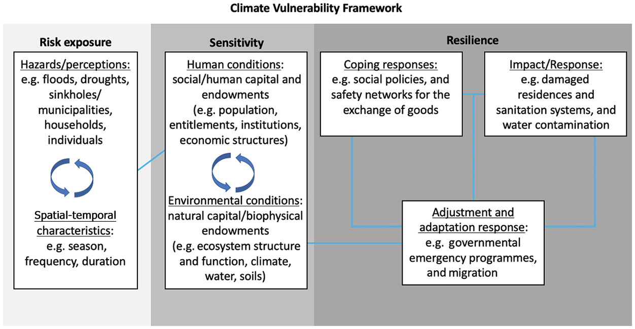
Climate vulnerability frameworks used in the academic literature stem from earlier models focused exclusively on exposure to such climate change risks as storm surges and droughts. These models were shown to be limited in their application to social and environmental vulnerability, given that, in order to map these phenomena, it was necessary to incorporate how exposure was experienced in a system along with its interactions and feedback. Recent frameworks have incorporated external social and environmental influences (e.g. the social, economic and political structures) and the multiple stressors or assets from human and environmental conditions that contribute to sensitivity – for instance, acknowledging groups such as children and the elderly that are more at risk. Recent frameworks acknowledge, too, that adaptations in response to these multiple stressors through time and space directly impact the capacity of a system to change while still maintaining the environmental and socioeconomic characteristics that are key to resilience or adaptive capacity. Here we recognize that various vulnerability frameworks have been proposed,(12) and that they tend to use three main subdivisions, which we reproduce as an exposure, sensitivity and resilience schema (Figure 1).
Details of the exposure, sensitivity and resilience components of the vulnerability framework used in this paper
III. Study Site: Four SCADEs in the Amazon Delta
The ADE is a highly climate-variable region formed by one of the largest estuarine areas in the world, consisting a drainage area of 6,150,000 square kilometres, with a water discharge of 200,000 cubic metres per second.(13) The estuary is influenced by the tidal regime, and its low-lying terrain is frequently flooded with freshwater. While the northern channel receives seasonally rich nutrients from the Andes, the southern canals do not have these benefits, as most of their water is received from the Tocantins River originating in Central Brazil.(14)
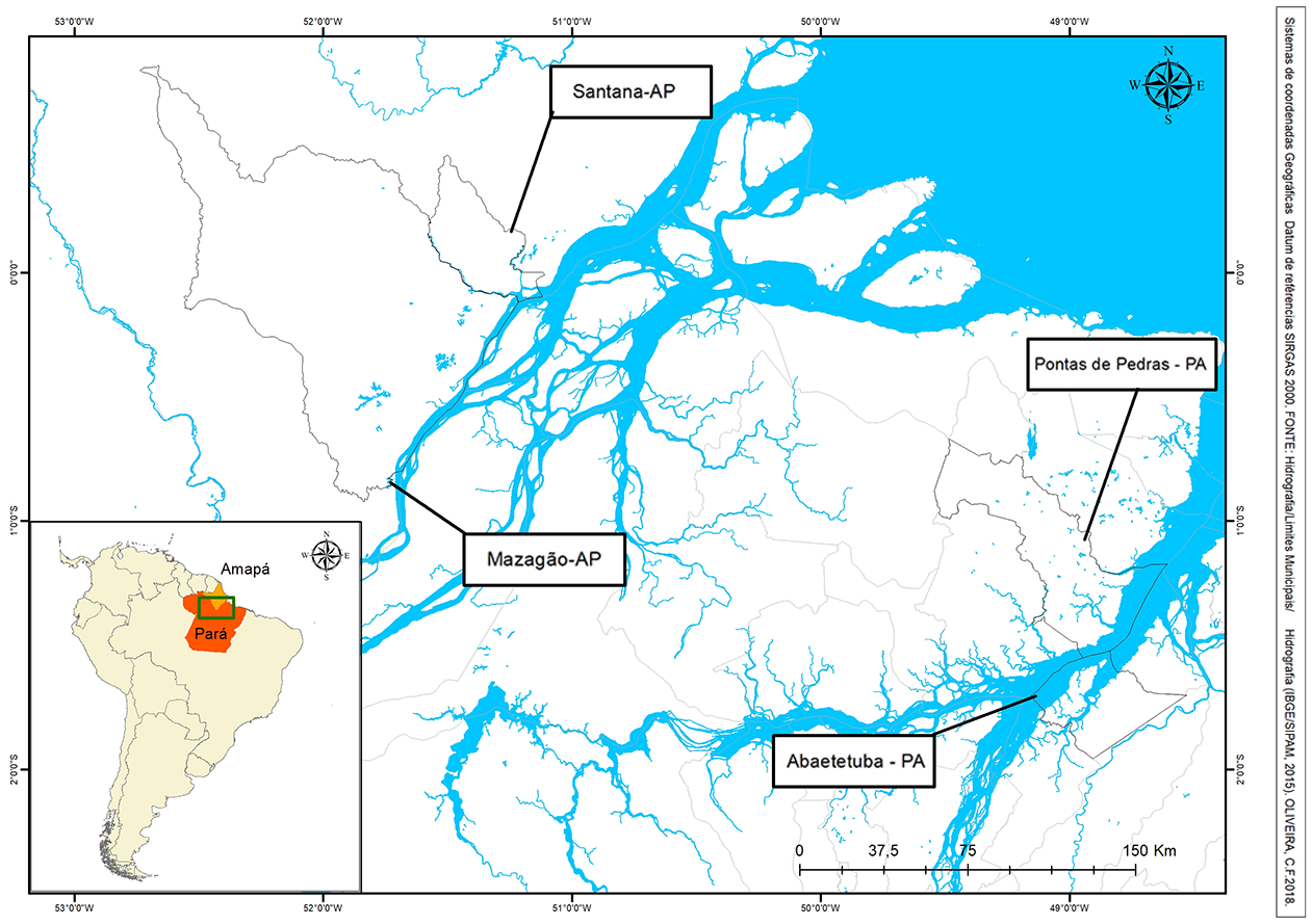
A study of climate vulnerability and urbanization in 41 municipalities of the ADE shows that in more than 15 municipalities, urban inhabitants make up more than 50 per cent of the total population, and in six municipalities, more than 90 per cent.(15) Although many small cities still retain some rural characteristics, the urbanization process, which has intensified in the last few decades, has rendered them some of the fastest-growing localities in Amazonia.(16) To understand how the inhabitants of fast-growing small cities are dealing with the constraints and opportunities produced by socioenvironmental changes, we conducted a study in four small cities: Ponta de Pedras, Abaetetuba, Mazagão and Santana (Map 1).
Locations of study sites, Amazon Estuary, Brazil
The four SCADEs selected in this research are expanding into terrain below sea level and are highly vulnerable to floods. Two are located in the state of Pará, in the North Delta (Abaetetuba and Ponta de Pedras), and the other two are in Amapá, in the South Delta (Mazagão and Santana). These four SCADEs were selected based on three main characteristics:
1) increased urbanization rates in the last 40 years
2) small or medium size, according to size classification brackets adopted by IBGE(17)
3) a function as service cities in the Amazonian urbanization hierarchy, represented by active mobility and trade, and the presence of substantial numbers of government jobs and services(18)
SCADEs evolved from mainly rural enclaves in the 1970 to some of the fastest-growing cities by 2010.(19) Most residents are of Amerindian, European and African descent, an ethnic mix present in the ADE since the colonial Portuguese era. SCADEs’ populations have historically based their livelihoods on diverse land and resource use activities, such as the management of timber, açaí and fisheries. The recent expansion of açaí to national and international markets has made this local palm fruit the main commodity in the region.(20) Small agricultural plots, by the same token, have been utilized and managed in the context of a dynamic cycle of floods in these low terrains for probably hundreds of years.(21)
Abaetetuba and Santana are considered medium-sized cities, with populations of about 83,000 and 99,000, respectively.(22) Both have experienced intense in-migration due to the establishment of large enterprises: the Albrás-Alunorte mining project in Barcarena, a town neighbouring Abaetetuba,(23) and numerous other industries in Santana due to the establishment of the Free Trade Zone of Macapá.(24) Ponta de Pedras and Mazagão are smaller towns with fewer than 30,000 people each, but in the last four decades, their urban populations have increased dramatically: six-fold in Ponta de Pedras and five-fold in Mazagão. Nowadays, all four small/medium cities are highly dependent economically on the government sector, as seen in their municipal Gross Added Value (GVA), which varies from 42 per cent to 63 per cent in terms of the rate of reliance on the public sector.(25) The service sector is the second most important (14–36 per cent) for the municipalities of Abaetetuba, Santana and Mazagão, while Ponta de Pedras relies mostly on cattle and agriculture. Industry is incipient, but in Mazagão and Santana a higher percentage of income is from industry (13–14 per cent) compared to Abaetetuba and Ponta de Pedras.(26)
IV. Methods
This research was conducted in two phases. First, we used secondary data on climate variables and examined these data under the climate vulnerability framework as the basis for the analysis of resilience in the four selected SCADEs (Abaetetuba, Ponta de Pedras, Santana and Mazagão). Second, we conducted an exploratory assessment, first interviewing key informants, and then convening focus groups with government actors, local leaders and residents. The key informants were identified using snowball sampling – we started with previous contacts of the research team in the agriculture sector in the government and extension offices. These activities enabled us to identify and analyse, along with focus group participants, the most noticeable hydroclimatic disturbances, the constraints and opportunities they produce, and the adjustments SCADEs residents and policymakers use in order to cope with them.
a. Secondary data
Four rainfall and temperature datasets were built using data gathered from the climatological stations nearest to the four selected SCADEs and collected over more than four decades (from 1 January 1968 to 31 December 2016 in the North Delta, and from 1 January 1961 to 31 December 2016 in the South Delta). These climatological stations were located in Belém (latitude -1°43’, longitude -48°43’ and altitude 10.00 metres), Cametá (latitude -2°25’, longitude -49°05’ and altitude 23.9 metres), Macapá (latitude 0°05’, longitude -51°11’ and altitude 14.46 metres), and Breves (latitude 1°68’S, longitude 50°48’ and altitude 40 metres). These four datasets were compared in order to detect possible repetitions and errors. For each climatological station, the elements analysed were annual and monthly average rainfall (millimetres) and days with daily rainfall greater than 70 millimetres. Changes in temperature over the period were analysed by estimating maximum and minimum annual and monthly average temperature (C°), and identifying days that were very hot (> 35C°), and days that were cold (< 21C°).
b. Primary data
Interviews with key informants
We conducted a preliminary assessment by interviewing multiple stakeholders primarily to provide information about the key problems faced by smaller cities, and to identify participants for the focus groups. First, we conducted 16 semi-structured interviews (using questionnaires) with key informants in Ponta de Pedras and Abaetetuba in April 2017, investigating the main climate change problems recognized by interviewees in these two cities. Subsequently, based on information from these first two cities, we used an interview guide to conduct 33 open interviews in Mazagão and 50 in Santana in order to triangulate and validate results. During this phase, interviewees provided the information for mapping the main actors involved with governmental and non-governmental organizations dealing with issues linked to climate change variables. These actors were then invited to participate in the focus groups.
Focus groups
Focus groups were organized in each selected SCADE in order to discuss the main extreme weather hazards, their frequency or intensity, and how they may have been influenced by climate change impacts. Opportunities and constraints on responses, recovery and resilience were also explored. Participants were selected based on their qualifications and functions within their institutions. We invited personnel from governmental organizations, local experts, representatives of neighbourhood associations and grassroots movements, and faculty and students from local universities. An appealing programme had to be developed as organizers of a number of trainings or extension events target similar audiences. There were 20 participants in the focus groups organized in Abaetetuba, 16 in Ponta de Pedras, 20 in Santana and 17 in Mazagão. We aimed for a diverse audience of no more than 20 participants in order not to compromise the discussion. The majority of participants were from local municipalities and some were from state-level offices; representatives of universities and neighbourhood and grassroots organizations were also included.
The first day was organized as a traditional focus group discussion around the themes mentioned above. Using this participatory methodology, attendees listed and discussed the different levels of stress produced by extreme floods, rainstorms, and drought spells or seasonal events on the livelihoods and environments of SCADEs. The second day was devoted to producing preliminary vulnerability maps using geographic coordinate points collected in and around neighbourhoods where focus group participants and local residents were identified as vulnerable to tidal and river floods. This activity enabled the research team to detect on-the-ground evidence and make personal observations, and participants said it was one of their main reasons for joining the focus group.
V. Results and Discussion
In this section, we discuss weather disturbances based on climate variables, describing long-term environmental trends found in the Amazon Delta near the four selected SCADEs (Subsection Va). Then we assess social and environmental vulnerability indicators using the climate vulnerability framework discussed previously as our theoretical background, with a focus on the four SCADEs under review (Vb). Finally, we bring together evidence from secondary data and results from focus groups’ discussions, which were informed by data collected in preliminary interviews (Vc). We detail the climate hazards identified in this participatory process and the opportunities and challenges for building more resilient SCADEs.
a. Climate variables
Climate change and variability in the ADE reflect complex and closely coupled relationships. In a highly heterogeneous climate such as the ADE’s, changes in rainfall patterns and temperature are likely to vary over short time periods and spatial distances. Rainfall and temperature data collected for more than three decades in climatological stations located in the delta, and near the four SCADEs selected in this research, provide valuable information for investigating and monitoring longer-term changes in climate variables in a highly dynamic context. Long-term collection provides sufficient data to assist in characterizing ongoing processes of climate change and variability, and to identify the frequency and intensity of weather anomalies in or near the four selected SCADEs.
The rainfall and temperature data show that climate trends in the ADE are becoming less predictable in their frequency and intensity, which closely affects the resilience of the four selected SCADEs as well as other expanding small cities in the region. While we found no clear trend from a wet to wetter climate based on our analysis of rainfall data from the four datasets, particularly for the North Delta, temperature data do show a consistent trend of a warm to warmer climate in the South and North Deltas. Figure 2 shows the clear tendency toward a warmer climate in the Macapá and Belém datasets. With regard to rainfall, although no trend was detected in our analysis, recent studies conducted with rainfall data of 150 climatological stations in the state of Pará have shown a wet to wetter tendency throughout several regions.(27)
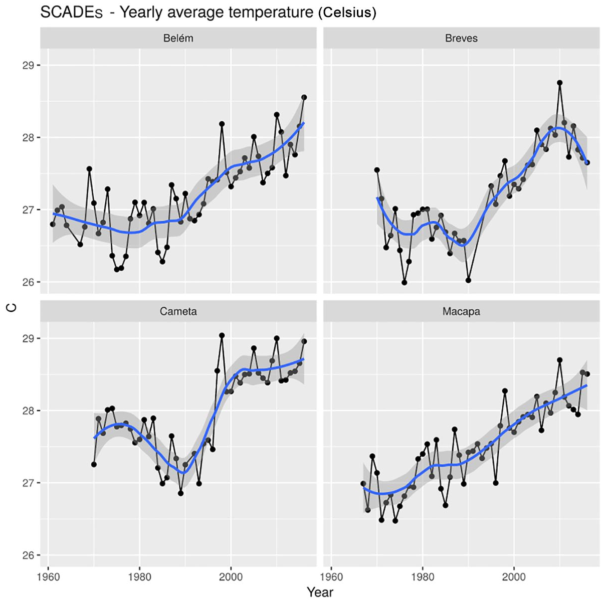
Average monthly temperature data over time
b. Climate vulnerability framework: small cities in focus
In this paper, we applied the climate vulnerability framework outlined in Section II to the study of the ADE region. We stress the sensitivity aspect within the area, understanding that the process of urbanization of SCADEs and other cities in the highly heterogeneous and dynamic context of the Amazon Delta has depended on residents’ capacity to respond to and recover from hydroclimatic events. The reproduction and improvement of this capacity over generations are also notable.(28) Moreover, we consider risk exposure in terms of how hazards are perceived by the people affected. Hazards perceived in the four SCADEs studied are outlined and discussed in Vc. This approach also fits under a climate vulnerability framework, moving away from a focus on exposure to extreme events, incorporating environmental and human conditions, as well as responses, adjustments and adaptations undertaken by populations at risk.(29)
Under the climate vulnerability framework, recent efforts have been made to assess human and environmental indicators composing the sensitivity to climate change exposure in urban areas of the ADE. Such studies have proposed indexes using data from “census sectors”, which are IBGE’s smallest areal survey units, and which include various subdivisions within small cities.(30) For instance, the vulnerability of the ADE was assessed through a multi-criteria analysis based on three dimensions (exposure, socioeconomic sensitivity and infrastructure) and weighted based on interviews with government technicians.(31) At the census sector level, the vulnerability index accounted for the percentage of the census tract receiving public water service, sewage and waste collection systems, the proportion of individuals considered at higher health and socioeconomic risk (children and elderly, low educational level, inadequate housing), cases of waterborne diseases, and average income levels.
The index methodology applied to investigating vulnerability in 41 cities in the ADE has shown that most cities are exposed to potential risk as a result of the combination of extreme weather threat, poverty and lack of infrastructure, and that between 60 and 90 per cent of the urban population lives in moderate or high risk vulnerability.(32) When applying the same methodology to the four SCADEs, we also show a general lack of infrastructure and personal assets, resulting in high vulnerability for all four SCADEs (Map 2). The lack of basic urban infrastructure is a key component in this assessment. For instance, wastewater collection has been a crucial service that is practically nonexistent in the SCADEs studied. The data on average family monthly income and residential trash collection also depict a scenario of high risk vulnerability. These are examples of variables included in the vulnerability index proposed by Mansur et al.,(33) which illustrate the reasons for the high vulnerability found in Abaetetuba, Ponta de Pedras, Santana and Mazagão. These four follow a similar pattern, as shown in the lower part of Map 2.
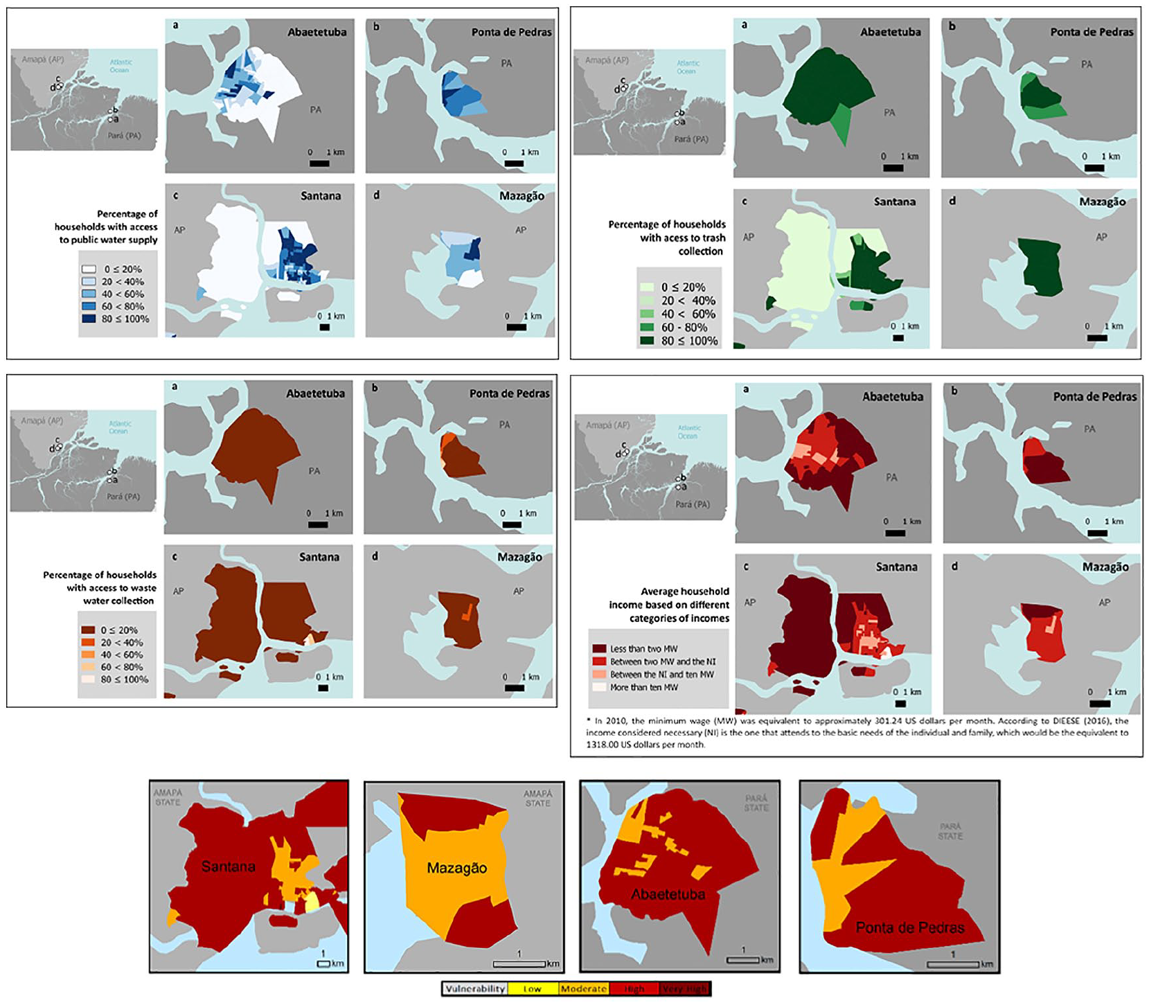
Maps with selected individual components of the vulnerability index proposed by Mansur et al. (above), and general vulnerability maps for Abaetetuba, Ponta de Pedras, Santana and Mazagão (below)
With the exception of Santana, in the other three SCADEs, more than 90 per cent of the urban population earns less than the minimum wage monthly. The proportion of homes connected to the urban water supply varies from only 41 per cent in Abaetetuba to 75 per cent in Ponta de Pedras. Vulnerability is further aggravated by a lack of sanitation systems (which affects between 68 per cent and 94 per cent of the population in the four cities). Human waste is dumped directly into the local natural environment, contaminating rivers and representing a direct source of disease and pollution for residents.
Although finer than municipal census data, census sector data are often not fine enough for assessing vulnerability or for providing useful information for urban planners and policymakers at the local level. For instance, while a few sectors appear to be served by the urban water supply system, people residing in these areas often lack access to water due to limited distribution systems, low water pressure, and problems with water quality. Census sector analysis is valuable and appropriate for investigating vulnerability to climate threats at the estuary scale, and for contributing to general vulnerability indicators for a given small city. However, the scale is still limited for providing useful information at the municipal level, as it does not capture local specificities including important details regarding access to basic services, with such concerns as contamination of the urban water supply or lack of plumbing maintenance. Furthermore, census data do not account for the perceptions of residents concerning these problems and the local knowledge necessary for resolution. Perceptions of local stakeholders around their vulnerabilities are reported in the following subsection.
c. Resilience in SCADEs: evidence from interviews and focus groups
Based on information from the interviews, participants were identified for the focus groups, along with relevant information for initiating their discussions. The focus group meetings were organized in each studied SCADE in order to understand the problems at the local level, therefore providing primary data relevant to policymakers at the municipal level. In all focus groups, the discussions were initiated by presenting a summary of the rainfall and tidal patterns and their impacts as recognized by key informants in the course of the interviews, and were developed as focus group participants discussed each of the issues from their perspectives. Results were organized by three themes:
1) participatory identification of main climatic hazards and trends and their correlation with secondary climatic data
2) impact of these hazards on livelihoods and urban service infrastructure
3) decision-making for responding to socioenvironmental disturbances, aiming for recovery and resilience
Hazards, perceptions and their impacts on SCADEs
Anecdotal information from focus groups corroborates the analysis of data from climatological stations, pointing to a trend from a warm to warmer climate in the ADE. However, participants also affirmed that the climate had changed from wet to wetter, a pattern not observed in the climatological dataset. Throughout the ADE, rainfall is quite abundant, with maximum rainfall occurring in the eastern Amazon, including southern Amapá, northeastern Pará, Marajó Island and northern Maranhão.(34) However, focus group participants reported that over certain periods in recent years, precipitation could be so high that the natural flow did not prevent the accumulation of considerable volumes of water, causing flooding in most cities in the delta.(35) Participants also recognized that excessive rainfall increased people’s vulnerability to infectious disease and could cause serious damage to housing, drainage systems and other urban infrastructure. Indeed, erratic and torrential rainfall, contributing to both flash floods and persistent groundwater floods (high soil saturation when the water table reaches the surface), were the main hazards discussed by focus group participants. These were reported to occur throughout the rainy season in all four SCADEs. Similar hazards and spatial-temporal characteristics were identified in focus groups in all SCADEs except in Mazagão, where landslides were less important, but which was the only place where fires and smoke were mentioned in both interviews and focus groups (Figure 3).
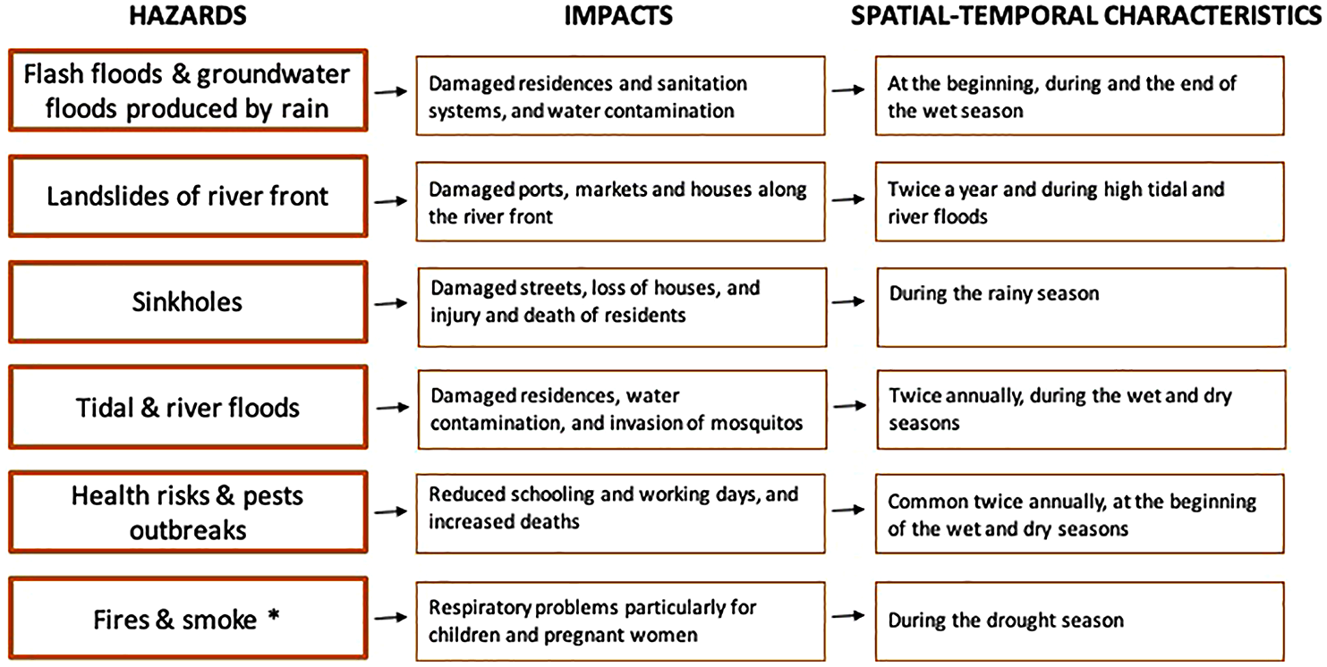
Summary of main hazards, impacts, and trends identified by focus groups participants in Abaetetuba, Ponta de Pedras, Santana and Mazagão
As the definition of hazards was linked to the daily lives of the participants, there were a few uncertainties as to what other hazards were of particular threat to SCADEs. Landslides along riverfronts and sinkholes that damage streets were identified alongside tidal and river floods as hazards that require attention in the present and prevention in the future (Figure 3). For instance, participants mentioned that the current drainage, sewage and water systems are increasingly limited in their capacity to withstand more frequent, strong storms that involve high-intensity rainfall over short durations. Flash floods and floods that persist for several days were also linked to health issues, including an increase in the number of cases of dengue, lymphocytic choriomeningitis (LCMV) and other viral infectious diseases.
Focus group participants emphasized that the impacts of hydroclimatic hazards on livelihoods and city infrastructure are increasing every year or season, even in the absence of extreme or catastrophic events. They also highlighted that disturbances in the local hydroclimatic regimes produced by extreme weather events and hazards such as flash floods, landslides and sinkholes are mediated by the resilience of SCADE residents. The question of how prepared residents and institutions of small cities are was continually discussed as key to most SCADEs’ resilience. Participants argued that, rather than focusing on impacts, it might be important to incorporate knowledge, technologies and strategies used by residents into sustainable and resilient urban planning. While the government should be the primary contributor to resilience, its actions are limited. Local government often focuses on urgent matters, such as the constant, routine demands of maintenance and response to disasters. The rate of unplanned occupations in lowland areas adds high demand to an already limited and obsolete sanitation infrastructure.
In terms of disasters, leaders in Abaetetuba mentioned the “São João accident”. This referred to a neighbourhood that sprawled along a coastal area below sea level, like many in the ADE, whose soil collapsed in January 2014, destroying 13 houses and damaging 39 others. There were no life-threatening injuries in the event, but people were displaced for months and many families lost all their belongings.(36)
Differing scales for resilience: governmental and household decision-making
In all four SCADEs, climate variability was perceived by participants in terms of an increase in weather hazards during the year. Focus group participants also recognized that SCADEs’ resilience depends on decision-making at the level of households, as well as at the municipality level. They reported that SCADE residents commonly change their livelihood strategies to respond to and recover from damaging floods, rainstorms and dry spells, while policymakers tend to focus their actions on relief assistance to victims of catastrophic events such as landslides. Local stakeholders acknowledged that early warning systems and other mitigation actions are helping them to be better prepared for catastrophic floods and droughts; however, they pointed out they are not prepared to deal with impacts on residents’ livelihoods and local environments resulting from severe rainstorms occurring annually.
An important characteristic of the urban development happening in these SCADEs is the predominance of embanking and paving entire neighbourhoods located in floodplains, as migrants transition from living in houses built on stilts (palafitas) to houses built on brick foundations. The majority of these neighbourhoods are the result of informal settlements (locally known as invasões), mostly in lowlands highly vulnerable to floods, locally known as baixadas. Through collective action, the residents of baixadas and other invasões gain support from municipal or government agencies to provide embankment, energy and sanitation services, in many cases without any long-term plan. Residents tend to rebuild their houses after the neighbourhood is embanked in the hopes that governmental provision of energy and sanitation service infrastructure will follow. While these embanked neighbourhoods become less vulnerable to tidal and river floods, they are highly vulnerable to flash floods, groundwater floods, pest invasion, outbreaks of infectious diseases and other weather-related hazards (Photo 1). Resilient cities, by contrast, should strive to conserve and enhance their capacity to mitigate the impact of weather anomalies by incorporating streams, swamps and other water bodies as part of the drainage system.
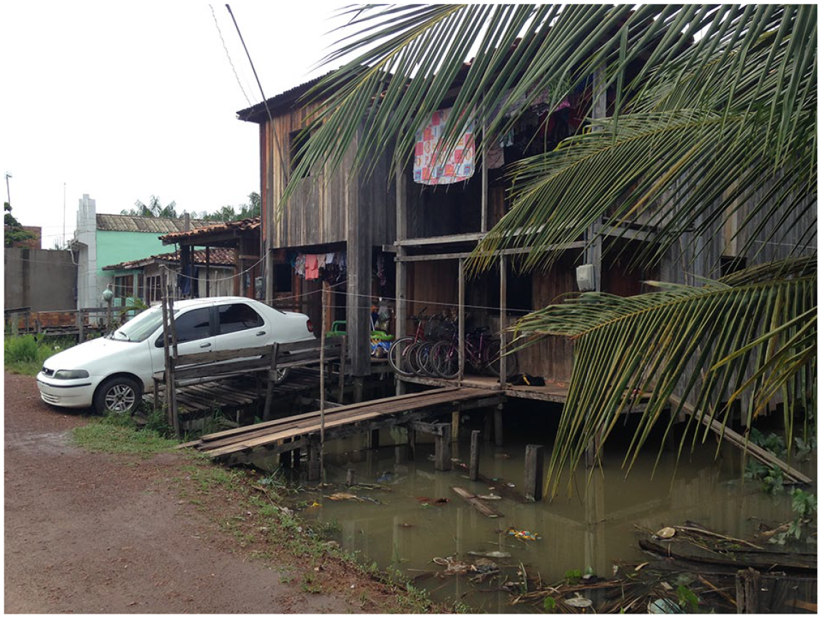
House in an embanked street in Ponta de Pedras, PA
While urban expansion through the occupation of public or private land may offer an opportunity for residents to build and own their houses, urban planners are often faced with difficulties when formalizing invasões. For instance, planners mentioned that building green and other recreational spaces is politically controversial and tends to generate conflicts with residents, and that embankments bring along short-term, necessary benefits in terms of transportation and other basic needs but aggravate risk over the long run, for instance by ushering in unstable structures prone to sinkholes and landslides.
Therefore, we recognize that while SCADEs have, for instance, occasionally managed to increase their institutional capacities for disaster relief by promptly applying for and receiving funds from the federal government to assist displaced families, all four SCADEs lack the institutional planning capacity to deal with the constant and incremental impact of rainstorms and groundwater floods on infrastructure, livelihoods and environments. Governments are commonly active in providing some infrastructure to invaded settlements but cannot cope with the rate of unplanned occupation, which limits their potential to respond fully to disaster risk reduction. Ultimately, this dynamic of floodplain urban occupation increases the risk over the long term. At the household level, residents do use rural and urban resources through sophisticated family, ethnic and neighbourhood social networks and collective action to obtain any available resources. Additionally, local knowledge is helpful in response to and recovery from annual and seasonal hydroclimatic and sociopolitical disturbances. At the same time, populations in high-risk areas do put pressure on local governments to embank streets, but drainage and sanitation services often do not result; residents can then do little themselves for disaster risk reduction. Understanding the limitations of institutional capacity and household resilience is a key element for dealing with present and future hazards, stresses and shocks in the social and physical landscapes of SCADEs.
Weak local governance and insufficient legal and financial incentives from state and federal government were considered by focus group attendees to be impediments to adaptive planning and urban management in the face of floods, sinkholes, droughts and other climate hazards. For instance, in all four SCADEs, local authorities are increasingly dealing with decaying infrastructure, unsafe structures, and compromised water and sanitation systems as well as other structures due to extreme precipitation, droughts and floods. They estimated the budget necessary for repairing the damaged infrastructure to be five times higher than the budget assigned to emergency relief programmes. Moreover, due to the current sociopolitical crisis in Brazil, there is little possibility that the federal government can mobilize financial resources for institutions and organizations based in small cities.
The focus group participants have suggested that if there is not an increase in economic resources, SCADE residents could be victims of disasters in the near future, considering that SCADEs will continue experiencing high rates of population growth and the formation of neighbourhoods within unstable and hazard-prone areas. For instance, participants reported that no local institutions or organizations have the financial resources and expertise adequate to manage water supply, and to fix and build the drainage systems and solid waste management that are necessary to prevent health emergencies, particularly during the wet and dry seasons. The lack of resources for smaller cities also reduces their capacity to offer emergency services and decreases their capacity for swift responses and preparedness.
VI. Conclusions
In environments with high climate variability, such as the ADE, changes in local rainfall and temperature patterns are likely to have differential impacts on livelihoods and environments. Appreciating the overall links between local knowledge and empirical rainfall and temperature information enriches the understanding of climatic trends, particularly when these are analysed using an evidence-based integrative framework and participatory methodologies for assessing risk and vulnerability, as in this research. The use of this approach assists in raising questions about how to develop more comprehensive policies targeting areas for intervention, consider alternative pathways, and highlight opportunities to manage risks and enhance urban resilience. Thereby, it provides guidance to sustainable management and policy decisions at regional and local scales.
Here, we combine secondary and primary data to show that stakeholders and local residents identify climate hazards, partially corroborating long-term data available from meteorological stations. We also show results from a vulnerability index created from census sector data. These expose the scale of social vulnerability in SCADEs linked to exposure to such hazards as floods and sinkholes, coupled with nonexistent or decaying urban infrastructure. The strategies employed in SCADEs to deal with the problems of urban development are still predominantly focused on dealing with disaster emergencies, as well as on embankment of lowlands, often as a response to demands from new urban residents. At first, urban residents tend to build their new houses on stilts, as they do in the rural areas. Once they settle in these unplanned neighbourhoods, usually below sea level, demand increases for embanked streets, which yield advantages for residents but also create other risks. Once embanked, neighbourhoods become less subject to river floods but more so to flash floods and persistent groundwater floods. The institutions and organizations based in small cities often lack sufficient resources to follow up with the secondary infrastructure needed after an embankment is established, such as sanitation systems and electricity. There is a concentration of resources and capacities for adaptation and mitigation at the national level, but very limited fiscal and human resources and capacities within state and federal agencies located in small and medium cities.
Evidence from focus groups conducted in the four SCADEs studied in this research also shows that local participation is critical for inclusive, resilient and adaptive development planning for small cities in the ADE. In addition, participants have suggested that the sensitivity of policymakers to emerging socioenvironmental disturbances is crucial for preparing the necessary infrastructure for SCADEs to deal with increasing damage to houses, streets and sanitation systems by hydroclimatic events. SCADE residents continue to deal with the challenges and opportunities brought about by climate change. Yet without the resources and capacities of local institutions, they will have limited resilience to socioenvironmental changes, including those arising from or aggravated by climate change. As in many other deltaic regions in low- and middle-income countries, the climate change adaptation agenda is not a high-priority issue. This is due to a context of social and economic struggles that limit urban planning practices, as observed in these SCADEs. Our study also echoes recent research on climate vulnerability arguing that climate change impacts are closely linked to how governments and local populations deal with the physical conditions of deltaic ecosystems, not to mention their economic and social dimensions.
Footnotes
Acknowledgements
We are grateful for our collaboration with all the participants in Abaetetuba, Ponta de Pedras, Santana and Mazagão.
Funding
The authors disclosed receipt of the following financial support for the research, authorship, and/or publication of this article: We are grateful for the research funding and support of the Climate Resilient Cities Initiative in Latin America (CRC). CRC is a joint initiative of the Climate and Development Knowledge Network (CDKN), International Development Research Center of Canada (IDRC) and Fundación Futuro Latinoamericano (FFLA). We also thank the Ministry of Science, Technology, Innovation and Communication of Brazil (MCTIC), the Coordination for the Improvement of Higher Education Personnel (CAPES) – Pró-Amazônia Program, the Brazilian National Council for Scientific and Technological Development (CNPq), and the Brazilian National Water Agency (ANA) for funding this research.