
Abstract
Pacific Small Island Developing States are often referred to as the “frontline” of climate change, facing an array of worsening climate-related shocks and stressors. However, despite their underlying exposure to climate change impacts, the role of Pacific Island cities as both an avenue for adaptation and sites of climate vulnerability is often overlooked. This paper reflects on two ongoing participatory action research projects conducted by UN-Habitat and research partners from Australian universities in Honiara, Solomon Islands, and Port Vila, Vanuatu. Findings from community consultations across 16 communities in these settings demonstrate the critical role of endogenous modes of resilience, as well as the strong correlation between these spaces and sub-city climate vulnerability. Cross-scale integration with climate resilience planning processes is then used to examine points of conflict between stakeholder interpretations of core functions within socioecological systems, demonstrating the importance of considering values and conflict within urban climate adaptation.
Keywords
I. Introduction
Small Island Developing States (SIDS) receive special attention in global climate change negotiations and related intergovernmental frameworks. This is a reflection of their extensive coastal hazard exposure, susceptibility to natural disasters, and the limited livelihood alternatives and economic development opportunities available to their inhabitants.(1) Correspondingly, global climate finance mechanisms have been mandated to prioritize SIDS, along with Least Developed Countries (LDCs), as articulated most recently through Article 9.4 of the Paris Agreement.(2) These multilateral climate finance mechanisms – such as the Adaptation Fund and the Global Environment Facility – allocated an estimated US$ 210 million to the Pacific region from 2010 to 2014, with bilateral and independent climate development assistance contributing a further US$ 538 million over the same period.(3)
The particular challenges facing SIDS were set out in a regional “Small Islands” chapter of the 5th Assessment Report (AR5) of the Intergovernmental Panel on Climate Change (IPCC).(4) Although much of its emphasis is on projected climate impacts, this chapter also acknowledges the need to consider climate adaptation planning in the context of disaster risk reduction and development needs, and the additional challenges faced by Pacific Island countries due to their isolation from global communications, transport and trade networks. AR5 was also the first IPCC assessment to dedicate a discrete chapter to climate risks and adaptation in the urban environment, thereby providing a stimulus for international networks and initiatives that now focus on cities and climate change.
The inclusion of both “climate action” (Goal 13) and “urban” (Goal 11) objectives in the 2030 Agenda for Sustainable Development reflects the centrality and interconnectivity of these two areas. With the world’s urban population projected to nearly double by 2050, and global greenhouse gas emissions needing to reach net zero by mid-century to achieve the more ambitious 1.5°C Paris target, the urgency in integrating these two agendas is clear.(5) With SIDS being similarly noted as targets for additional official development assistance and finance within the 2030 Agenda, and Goal 17 specifically addressing synergies across these financing mechanisms, such integration is strongly mandated across these disparate intergovernmental spheres.
Despite this, planning for climate change in the cities of Pacific SIDS has been limited to date. This reflects a wider tendency for international development initiatives in the region to target rural infrastructure, remote access to services, and (non-urban) ecosystems.(6) This rural focus is also indicative of the characterization of SIDS as subsistence-based, non-urban settings, a viewpoint echoed by governments seeking to reinforce often-nascent national identities through links to traditional ways of life and diverse cultural and linguistic constituencies.(7) The shortcomings of sustainable urban development in the region are reflected in the New Urban Agenda (NUA), an internationally agreed document that emerged out of the third United Nations Conference on Housing and Sustainable Urban Development (Habitat III). This document was tasked with guiding the urban dimensions of the 2030 Agenda in cities and human settlements. Notably, the New Urban Agenda includes a “call to action” focusing particular attention on SIDS in light of their heightened vulnerability to the adverse impacts of climate change.(8)
This paper reflects on two participatory action research projects that respond to these various calls for action. These projects have developed urban resilience and climate action plans for Honiara and Port Vila, the respective capital cities of the Solomon Islands and Vanuatu. These parallel studies have been led by the United Nations Human Settlements Programme (UN-Habitat), in partnership with Australian academics and national government ministries in charge of climate change, housing and urbanization. Each initiative has built predominantly on the perspectives and expertise of local government, civil society, and both formal and informal community representatives, in order to elicit the sub-city climate vulnerabilities, adaptation needs, and at times divergent priorities for action across the diverse range of actors present within Pacific urban domains. At the same time, these community-based understandings have been targeted through and cross-referenced with scientific climate data and quantitative socioeconomic information. This has allowed for the targeting of adaptation actions at sub-city scales, and the management of uncertainty through the co-production of climate knowledge.
Presented in the form of case studies from these small island developing cities, the findings from this ongoing initiative demonstrate the need for the integration of community social structures, capacities and forms of knowledge with institutionalized climate science, particularly in the rapidly growing informal settlements that prevail in low- and middle-income countries. Modes of endogenous climate resilience are also uncovered; these are capacities that operate at a sub-city level but are largely untapped by international development institutions and climate finance mechanisms. An emergent concept, endogenous resilience has been defined by Ziervogel et al. as “where systems create, or build on and enhance, people’s own capacity and resilience”.(9) The concept – in contrast, but not necessarily in conflict, with more systemic or top-down approaches – provides a paradigm for legitimizing community-derived capacities within climate-resilient development programmes. The implications for achieving sustainable urban development in SIDS, under the persistent threat of climate change, are then considered in light of the forthcoming 6th IPCC Assessment Report, the 2030 Agenda for Sustainable Development, and other related global directives such as the Paris Agreement and the NUA.
II. An Urbanizing Pacific
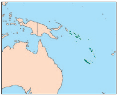
Small Island Developing States were first formally recognized in 1992 through Agenda 21 – the outcome document of the United Nations Conference on Environment and Development – and have subsequently become an established and discrete bloc within the UN system.(10) Three major UN SIDS conferences have subsequently been held, each developing SIDS-specific UN agendas: the Barbados Programme of Action (1994); the Mauritius Strategy of Implementation (2005); and most recently the SIDS Accelerated Modalities of Action (SAMOA) Pathway (2014).(11) In total, 38 UN Member States identify as SIDS: 9 from the Atlantic, Indian Ocean, Mediterranean and South China Sea (the AIMS group); 16 from the Caribbean; and 13 from the Pacific. A further 20 non-UN Member States and associates of regional commissions are also classified as SIDS. An overview of SIDS, which includes the subregions of Melanesia, Polynesia and Micronesia, is shown in Map 1.
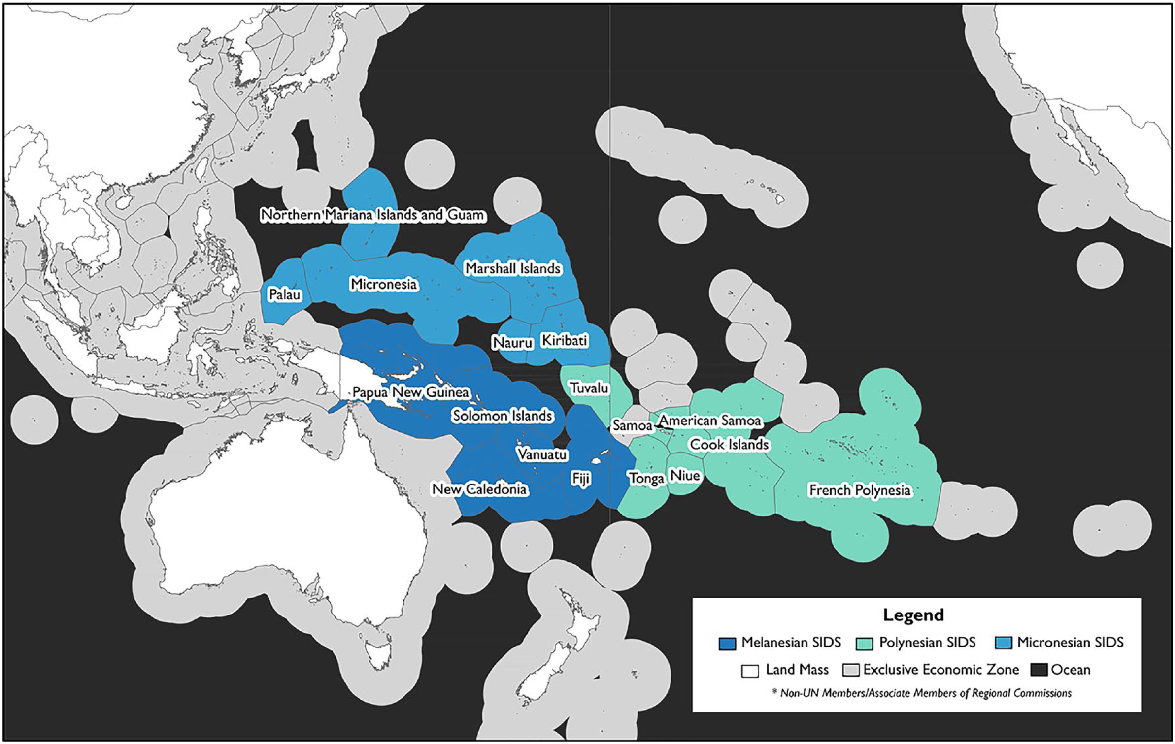
Pacific Small Island Developing States by subregion
The Pacific is often overlooked as an area of urban growth. As of 2015 Pacific SIDS are estimated to contain only 2.56 million urban inhabitants – 23 per cent of the region’s collective population.(12) Over the next three decades, however, the Pacific is projected to double its urban population at a growth rate well above the global average, despite limited land resources, insufficient urban employment opportunities, and a dependence on expensive international trade for imported cash economy goods and export supply chains. Analysis of changes in informal settlements from 1990 to 2014 by UN-Habitat also shows that growth in the number of urban dwellers in the Pacific living without adequate access to drinking water, sanitation, durable housing, living space or secure tenure has kept pace with overall urbanization, remaining at roughly 25 per cent of the Pacific’s urban population.(13)
Official figures in a number of Pacific SIDS underrepresent urban populations that are no longer contained within outdated municipal boundaries. These delineations persist as historical legacies of the establishment of administrative townships on unceded land by colonial powers. In many areas, while alienation of these central areas often remains unresolved, peri-urban customary land rights have been retained, resulting in dual governance systems that prevent municipal reclassification of peri-urban zones (a process that would effectively void perpetual customary land rights). As McDonnell et al. note, “the blurred administrative lines and boundaries of urban centres and their peripheries result in fuzzy responsibilities that allow state actors and customary owners to exclude urban settlements and their communities from access to services and fair land dealings”.(14)
Figures from Vanuatu’s most recent 2009 national census, for instance, show Port Vila as having 44,039 inhabitants, equating to 18.8 per cent of Vanuatu’s population.(15) However, consideration of a peri-urban region, comprising rural-to-urban migrant communities dependent on the city for employment and services (at a radius of approximately 10 kilometres from the centre of Port Vila), reveals 62,678 inhabitants within the greater metropolitan region, equating to 27 per cent of the national populace.(16) Inclusion of the country’s second most populous city, Luganville, takes Vanuatu’s urbanization level to 32 per cent, well above the 24.5 per cent recorded by the United Nations Department of Economic and Social Affairs (UNDESA).(17)
Rates of urban growth are even more substantially underestimated due to the generally more rapid expansion of peri-urban zones than their established municipal counterparts. Official figures show Port Vila as having an average annual population growth rate of 4.8 per cent between 1999 and 2009. However, inclusion of this wider peri-urban region increases this rate to 6.5 per cent per annum.(18) A similar situation is evident in Honiara, where municipal population growth over the same period averaged 2.7 per cent per year, but where inclusion of the adjacent peri-urban wards of Tandai and Malango increases this rate to 4.4 per cent.(19) The observed growth in Honiara is all the more notable given the civil unrest between migrant communities from the neighbouring island of Malaita (Malaitans) and the local inhabitants and customary landowners of Guadalcanal (Guale). Known as the “Ethnic Tensions”, this unrest persisted throughout the first half of the census cycle and resulted in a third of the capital region’s population being displaced due to land conflicts, with more than 23,000 settlers returning to Malaita as a result of land-based conflict with armed militia from Guadalcanal and an estimated 11,000 Guale fleeing the Malaitan-dominated capital.(20)
Gaining an understanding of the heightened significance of land rights, tenure, associated access to ecosystem services, and cultural identity in Small Island Developing States is a critical precursor to the development of effective urban climate adaptation strategies in such settings, and provides an important background to the two research projects reflected on here. As Rawlings relates, the nature of urban identity in the Pacific can largely be traced to colonial dispossession and contested migratory rights to the city. In the case of Port Vila, this is reflected in observations from members of one customary landowner group: “Vila belongs to man Efate, not to man aelan” (Vila belongs to the people of Efate, not to the people of other islands).(21) In the Solomon Islands, the Pidgin term man blo taun (person from town) is a descriptor that indicates both malicious intent and a lack of individual place-based identity, while in Vanuatu man Vila (person from Port Vila) is considered to be similarly derogatory.(22) It is notable that the French–British Condominium that governed Vanuatu – then known as the New Hebrides – prevented entry of the indigenous inhabitants of Efate Island into Port Vila from its establishment as a municipality until the late 1950s. This reinforced the alienation of tenure through race-based restrictions of movement.(23)
In place of an urban identity is the maintenance of a multiplicity of cultural structures derived from migrants’ island origins, which form a pervasive set of non-institutional social frameworks known as the wantok system (literally, “one language”). These networks – built around the more than 200 distinct spoken languages used across Vanuatu and the Solomon Islands – provide entry points for both new and circular migrants, and are connected through intermarriage and extended families.(24) As proposed by Moore, “in urban areas, wantokism and closer kinship become a method of organising space, and for newcomers is a way of surviving the harsh, money-driven environment”.(25) At the same time, wantok networks disrupt imposed Western norms of institutional governance, and can contribute to nepotistic tendencies that persist across all levels of government bureaucracy, fragmenting resources and conflicting with nascent democratic processes.(26)
Largely as a product of the various factors outlined above, urban governance in Honiara and Port Vila has been consistently neglected in the three-and-a-half decades since both the Solomon Islands and Vanuatu achieved independence – a period that has coincided with a step change in rural-to-urban migration. In the case of Honiara, the failure of urban planning is evident in the more than one-third of urban inhabitants who live informally, without legal tenure to the land that they occupy.(27) The “Temporary Occupation Licence” (TOL) system, originally introduced by the British administration in the decade before independence to cope with an influx of migrants to the newly established capital, has also fallen into disrepair. All but 10 of an estimated three thousand TOLs were found to have lapsed in a 2006 audit.(28) Despite subsequent efforts to regularize the now more than 30 large informal settlement zones across Honiara, government resources to survey and subdivide these areas are currently unable to keep up with the rate of informal urban growth.(29) Outside of these areas an additional 10 informal settlement zones have emerged, while growth has now begun again on customary and commercially leased land beyond the city boundary. Numerous additional dwellings have also been established on roadsides and other public easements, as well as in zoned areas of the city such as the National Botanical Gardens and city cemetery.
A similar proportion of Port Vila’s population occupies land through an equally diverse range of informal tenure arrangements, from customary occupancy agreements (based on the exchange of goods and services) to communal leases and subletting arrangements for inner-city blocks.(30) Although a 2012 survey by the National Housing Corporation found 13,145 informal settlers within the official urban area (equating to 29.9 per cent of the city’s official population at the time), extensive peri-urban informal areas, including a large settlement of 5–6,000 inhabitants adjacent to the Port Vila landfill site, suggest the total figure across the wider metropolitan Port Vila area is substantially higher.(31) This, as in Honiara, is a product of a general malaise in urban planning processes. Port Vila has not had a gazetted zoning plan since before independence, and the National Building Code is effectively unenforced, as is evident in the audit of the extensive damage to housing in Port Vila following Tropical Cyclone Pam in 2015.(32)
Urbanization in these two Pacific SIDS can thus be characterized as much by the diversity of intra-national sociocultural networks as by the transition that their migrant communities have made from rural, subsistence livelihoods to a cash-based, urban economy. These networks and social structures are both enabled by, and largely replacements for, an urban governance and institutional framework that is severely lacking. This drives an ongoing expansion of informal settlements, economies and extra-governmental structures (including church, quasi-customary and island-based organizations). Further, as elaborated below, the maintenance of these traditional norms and customs extends beyond wantokism into hybrid livelihoods and knowledges that operate not only in informal, but also formal, domains within Pacific cities.
III. Planning for Climate Change – A Participatory Urban Adaptation Methodology
It is within these rapidly growing, informal, and socioculturally diverse urban contexts that the two participatory climate planning processes that underpin this research have occurred, each having been initiated by UN-Habitat in 2012. Notably, the progress of both projects has been interrupted by major climate-related disaster events. This reflects the hazard-prone setting that has historically shaped Pacific SIDS, as well as the increasing risk presented by climate-related hazards due to climate change. Honiara faced a 1-in-100-year extreme rainfall event in April 2014, resulting in flash flooding, extensive destruction of housing, and damage to critical urban infrastructure (known locally as the “April Floods”). Port Vila encountered Tropical Cyclone Pam in 2015. This was a Category 5 cyclone that caused over US$ 449.4 million of loss and damage, equivalent to 64.1 per cent of Vanuatu’s gross domestic product.(33) These two events encapsulate why Vanuatu and the Solomon Islands are often considered two of the most at-risk countries for natural disasters. For instance, the two countries ranked 1st and 6th respectively over the period 2012–2016 in the World Risk Report of the United Nations University’s Institute for Environment and Human Security.(34)
UN-Habitat’s Planning for Climate Change framework centres upon a climate vulnerability assessment approach that integrates spatial analysis of quantitative socioeconomic and natural hazard exposure data with community and expert observations. This approach provides the basis for the participatory development and prioritization of adaptation actions through a stakeholder and community-driven methodology.(35) Climate vulnerability, as applied here, can be expressed as a function of three groups of variables: 1) climate hazard exposure; 2) the sensitivity of the assets and individuals exposed; and 3) their adaptive capacity to respond in the event of – and subsequent to – a hazard occurring.(36) This model provides for a sophisticated understanding of sub-city variations in vulnerability, allowing the targeting of critical infrastructure, at-risk settlements, and adaptation planning at different scales of local and community governance.
Critically, the integration of “top-down” and “bottom-up” forms of data at the vulnerability assessment stage allows subsequent sub-city action planning to focus on those areas that need it most, referred to as “vulnerability hotspots”. At the same time, identification of nested institutional and community social structures ensures that participatory action planning can be undertaken by the relevant decision-makers at each city scale. In the case of the hotspots, this is driven exclusively by local community stakeholders and organizations. Variations of the framework are being applied by UN-Habitat in approximately 40 cities across the Asia Pacific region, with five cities in Pacific SIDS at various stages of the Planning for Climate Change process.
Honiara’s Climate Vulnerability Assessment was completed in 2014, shortly before the April Floods,(37) and a comprehensive Honiara Urban Resilience and Climate Action Plan (HURCAP) was endorsed by national and local levels of government in March 2017.(38) Implementation of the HURCAP, supported by the Adaptation Fund, is currently underway as part of a four-year work programme (2018–2022), which will complete the third of four modules that constitute the cyclical UN-Habitat framework (with monitoring, evaluation and revision to follow as the final stage of the process). A Vulnerability Assessment for Greater Port Vila was endorsed by national and municipal governments in October 2015 – finalization that was delayed by the impact of Tropical Cyclone Pam – and an Urban Resilience and Climate Action Plan for the city was undergoing final drafting and consultations as of late 2018.(39)
The Planning for Climate Change framework provides a suite of 42 tools that have formed the basis for the approach taken in each city, as set out in more detail in the HURCAP and Greater Port Vila Vulnerability Assessment report. In each case, reanalysis of local climate records, downscaled climate projections, hazard mapping, and socioeconomic data were integrated with community and institutional stakeholder observations to form the basis of the assessment of climate vulnerability at whole-of-city and sub-city scales. Participatory planning processes were then conducted through workshops and focus groups. The focus groups were predominantly conducted inside target communities through local structures, identified through the scoping of differing spatial, denominational and island-based alignments, while the workshops were conducted within institutional settings. Common languages – Solomon Islands Pidgin and Bislama in Vanuatu – were used in community discussions and were translated to and from English where needed for research team members, the conveying of scientific information, and the completion of activity sheets and surveys. English is spoken fluently by the majority of both urban ni-Vanuatu (inhabitants of Vanuatu) and Solomon Islanders, particularly within government, and was therefore used for institutionally focused research activities.
In the case of Port Vila, city-scale action planning workshops included representatives from organizations and interest groups such as the Malvatumauri (Vanuatu National Council of Chiefs), the Vanuatu National Women’s Council and the National Council of Churches. Action planning was also conducted with government stakeholders through the National Advisory Board for Climate Change and Disaster Risk Management, the Port Vila Municipal Council, and the Shefa Provincial Government (the responsible local authority for Port Vila’s peri-urban area). Action planning at a community scale was targeted at vulnerability hotspots and built on community-led transect walks (designed to ground-truth and supplement city-scale quantitative observations of climate vulnerability). Household-level survey data from each of the 10 vulnerability hotspot communities also identified local ecosystem dependencies, with action planning workshops used to develop ecosystem-based adaptation options.(40)
In Honiara, a similar process was undertaken with more than 180 stakeholders. In addition, a two-day action planning forum brought together representatives from ministries, informal settlements, utilities and civil society to develop ward-level actions and share experiences of climate vulnerability, coping mechanisms, and other cross-scale issues. Training was also undertaken with staff at the National Disaster Management Office in an effort to mainstream the Planning for Climate Change methodology into other programmes of government. Action planning workshops were similarly conducted with civil society, municipal and national government representatives, and other associated agencies (such as Solomon Water). More interactive workshop activities were developed exclusively for engaging with young people, represented through the Honiara Youth Council, and women, with sessions that were run through Vois Blong Mere, an independent media organization that advocates for women’s rights and voices in government.
Despite efforts to ensure gender equality in representation, women represented only 26 per cent of stakeholders engaged in Honiara, although their representation in community-based activities was higher (35 per cent). The overall workshop, transect walk and interviews in Port Vila were more balanced, with 45 per cent of participants being women, and community surveys were completed by more women than men (60 per cent across the 10 communities). A key limitation of the study was the lack of a detailed analysis of adaptation needs and climate vulnerability disaggregated by gender, particularly in light of the limited representation of women both at senior positions in government institutions and within many community leadership structures. It was also noted that, although they were widely referenced by peri-urban informal settlers, customary landowner groups did not contribute directly to the action planning process, and were instead included as a key engagement group to target in subsequent implementation phases.
IV. Building on Endogenous Climate Resilience
Findings in each city identified a complex array of cross-scale climate vulnerabilities. In large part these stemmed from decades of shortcomings in planning for urban development, coupled with the misalignment of imposed international standards for built form, infrastructure and service provision (embodied within legislation and building codes) with the realities faced by households, in terms of their cash incomes but also given the hybrid livelihood incomes and pooled resource use across family networks. This phenomenon was most evident in the hotspot communities, where informal tenure arrangements further limited or prohibited investment in infrastructure – thus exacerbating climate sensitivity in areas often already highly exposed to climate risks. However, the longevity of communities within these hotspots, despite the absence of government capacity to support adaptation or responses to climate-related disaster events, points to alternative, endogenous sources of climate resilience. It is therefore argued that it is these capacities that have enabled Port Vila and Honiara’s informal communities to persist despite their heightened vulnerability to climate-related shocks and stresses.
Despite the lack of institutional governance frameworks, the integration of “top-down” quantitative scientific datasets was still demonstrated to be able to enhance endogenous resilience, as well as “bottom-up” community-based qualitative information and observations. The former included downscaled climate change projections(41) as well as risk maps and meteorological records, while the latter ranged from local observations of changing climatic and environmental conditions to extensive surveying of adaptive capacity and community-level transect walks and interviews. Although this approach was necessitated by the paucity of data across both of these domains (as well as the uncertainty in both downscaled climate projections and future urban changes), the inherent benefits of cross-referencing different perspectives of climatic and environmental change quickly became evident during the research process.
One such example can be found in the consultations that took place in Port Vila’s peri-urban informal settlement of Blacksands. This drew out numerous observations from longstanding community members on the level of the Tagabe River – a water source used for clothes washing, bathing, and the irrigation of urban agriculture – which they claimed had fallen substantially in recent years.(42) Although this was initially perceived by the community as being driven by climate change, cross-examination of Port Vila’s long-term rainfall records demonstrated no observable trend in annual rainfall, despite substantial inter-annual variation (ranging from 800 millimetres to over 4,000 millimetres).(43) Modelled climate projections were similarly inconclusive on both the direction and magnitude of annual rainfall change, with dry-season rainfall projected to reduce by no more than 0–2 per cent (with an uncertainty range of -11 per cent to +12 per cent) by 2030 under both high and low forcing Representative Concentration Pathways(44) (RCPs).(45) Subsequent investigations identified that upstream extractive processes for commercial and industrial uses, as well as that by the city’s water utility, had intensified significantly over recent years as a product of the city’s rapid growth, providing a more likely explanation of the observed change in river level. In turn, the dependency of the rapidly growing city as a whole on a limited, unconfined aquifer for potable water became evident, along with urban encroachment into the previously protected upstream catchment zone.(46)
The Blacksands example is illustrative of a common issue faced in applying climate change projections in urban settings: namely, that the assessment of vulnerability to climate impacts cannot be disentangled from locally driven human disruption of ecological and environmental systems. Similarly, the development of resilience-building adaptation planning processes cannot be considered in isolation from other non-climate shocks and stressors. This was more broadly demonstrated in the compilation of climate-related issues identified and prioritized by Honiara’s stakeholder representatives and community members, a process conducted as part of the preliminary scoping work for the HURCAP. Figure 1 illustrates these issues in a compilation of focus group activities conducted with government representatives, four hotspot communities, the Honiara Youth Council, and Solomon Water. The depicted scale reflects issue frequency, which ranged from all 13 focus groups rating an issue as being of significance down to a single group.
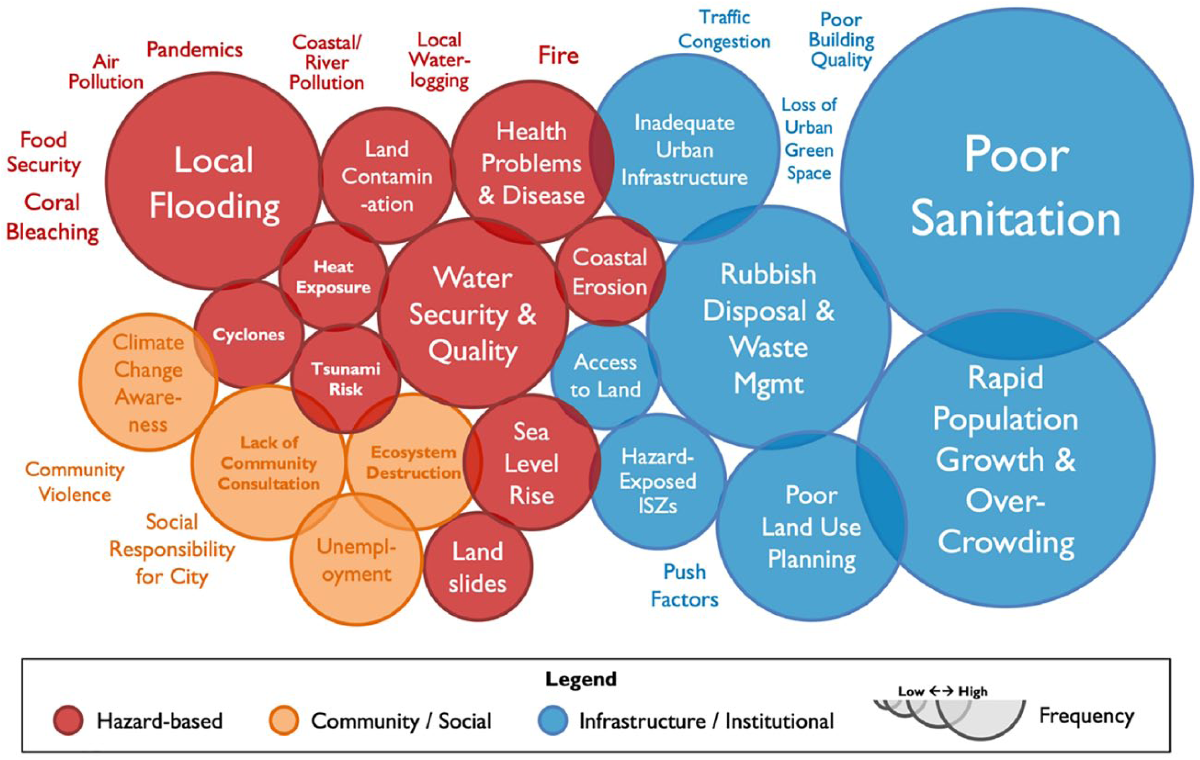
Climate-related issues identified by Honiara stakeholders and community representatives
It is important to note that while many of the issues identified by community members and institutional representatives are not directly attributable to climate change (nor immediately recognizable to non-experts), in urban settings this more holistic understanding of resilience – that is, inclusive of non-climate shocks and stressors such as geo-hazards and urban infrastructure failure – reflects the interconnectivity of climate vulnerability with the overall function of the city, as well as the capacities of its citizens.(47) For example, although “poor sanitation” is not being directly exacerbated by climate change in most instances across Honiara, the degraded nature of sewer outfalls and networks, coupled with the lack of connectivity to this network for 70 per cent of the city’s inhabitants, severely increases the risk of disease and pollution during heavy rainfall and storm surge events.(48) Consideration of these secondary factors through a vulnerability assessment framework, therefore, enables a more nuanced understanding of adaptation needs and priorities.
The integration of community observations with non-climate quantitative data and governance and policy frameworks was also shown to be of heightened significance in the development of adaptation actions – in particular, in informal settlements where complex community arrangements emerged outside of official governance structures. In Honiara’s informal settlement of Koa Hill, the settlement’s social structures are divided along church-based denominational lines, at odds with the two government-defined informal settlement zones (ISZs). Community consultations identified four sub-areas through which shared informal infrastructure was governed, based on Anglican (Zones 1 and 2) and Southern Seas Evangelical Church (Zone 3) denominational membership (as shown in Map 2). These included community committees with youth representatives, designated women’s groups, and regular meetings to address community needs. Notably, Zone 4 was a “mixed” community, and subsequently lacked the community infrastructure and governance structures operating in Zones 1, 2 and 3.
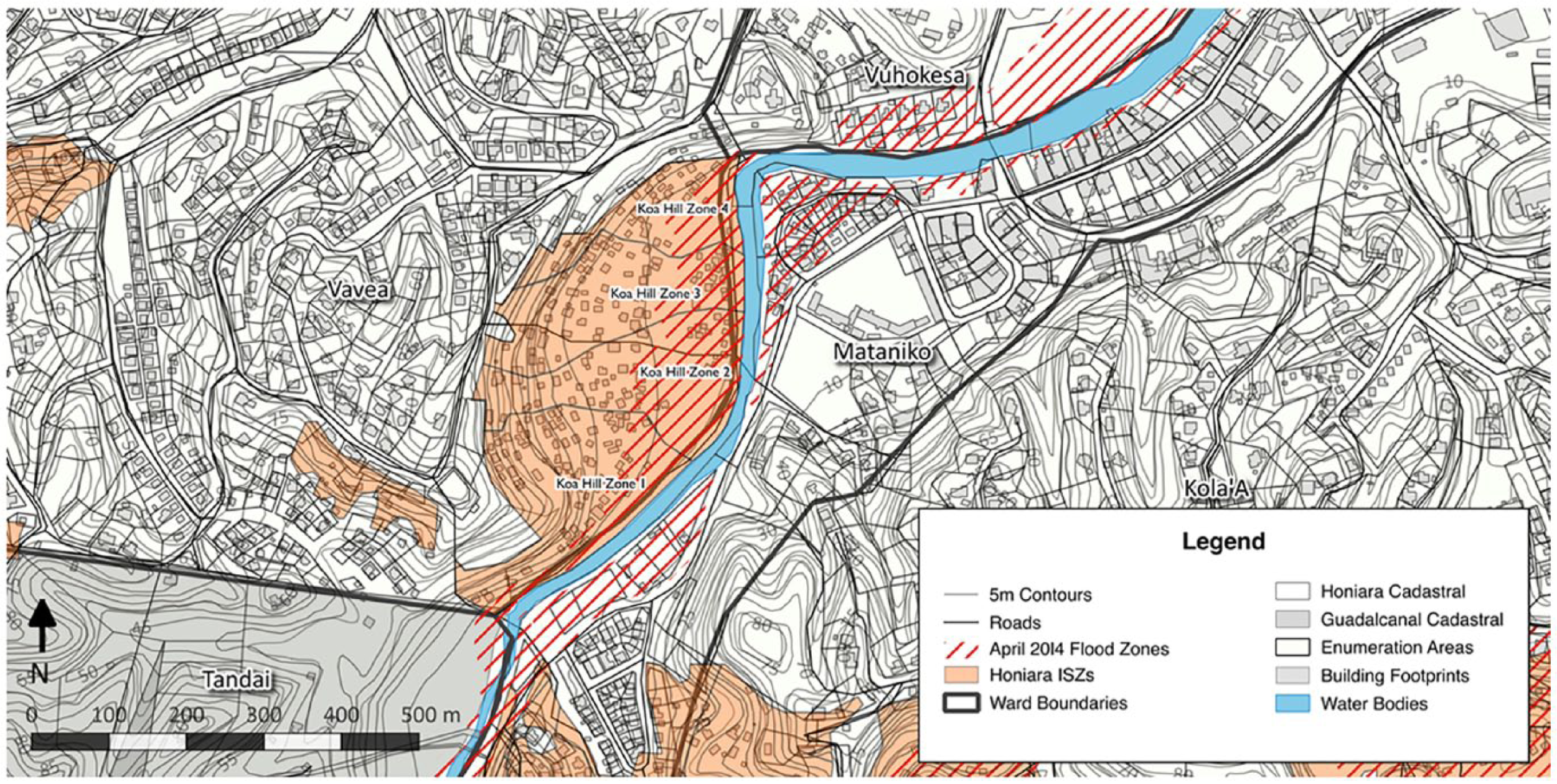
Koa Hill, Honiara: community zones and hazard areas
It was through these denominationally based community structures that the settlement’s inhabitants were observed to be preventing the resettlement of high-risk flood zones along the Mataniko Riverbank. These are areas where housing was destroyed and lives lost during the April Floods, as shown in Map 2. Access to natural springs in the hillside for drinking and washing water was also structured through community-constructed pipe networks that aligned with these areas, with three–four households sharing and maintaining connected standpipes and drinking and washing water infrastructure. Thus, despite only 7 per cent of households in the southern Koa Hill ISZ being recorded as having potable water access in the 2009 national census, households reported sufficient levels of drinking water. Workshop participants even claimed that it was of better quality, and had more consistent pressure, than that accessible through the local water utility.(49) Community priorities for action were therefore focused on the prevention of encroachment by neighbouring settlements adjacent to the water source, rather than access to utility supply.
V. Informality, Vulnerability and Resilience
Informal settlements are defined as areas of dwellings that lack one or more of five characteristics: improved drinking water; adequate sanitation; durable housing; adequate living spaces; and secure tenure.(50) Despite a lack of consensus on a global definition of “secure tenure” (a variable that is therefore excluded from international calculations of informality), UN-Habitat estimates that in 2014 there were more than 880 million inhabitants of dwellings that meet one or more of the first four characteristics. This is an increase of 192 million people since 1990.(51)
By definition, informal settlements therefore have a heightened level of climate sensitivity – a product of their lack of physical infrastructure as outlined above. Less clear at a global scale, however, is the correlation between informal settlements and climate-exposed urban areas, despite a tendency for informal settlers to occupy at-risk land such as floodplains due to the prevention of formal development in these areas.(52) Similarly, more complex calculations of adaptive capacity – the third component of the vulnerability approach applied here, which acts to offset exposure and sensitivity – identify informal capacities not otherwise present in formal settlement areas (such as the decentralized drinking water source in Koa Hill discussed above).
As noted in Section III, climate vulnerability was assessed in each city through a spatial model. This process integrated key aspects of these three sets of variables in order that the sub-city variations in Honiara’s vulnerability could be assessed at various scales. This assessment (building on secondary quantitative data, but also stakeholder and community knowledge of spatial climate exposure and sensitivity) was then ground-truthed with a focus on climate vulnerability hotspots and critical infrastructure. The output of the sub-city assessment of climate vulnerability in Honiara – illustrated in Map 3 – demonstrates a high level of correlation between the city’s extensive informal settlement zones and key thresholds for hazard exposure, climate sensitivity, and limited institutional adaptive capacity. Additionally, areas of rapid population growth correlated with a number of these settlements, suggesting that their inhabitants would be experiencing further social fragmentation, with newcomers less able to cope with a natural disaster event due to their lack of familiarity with urban disaster response systems and hazard zones.
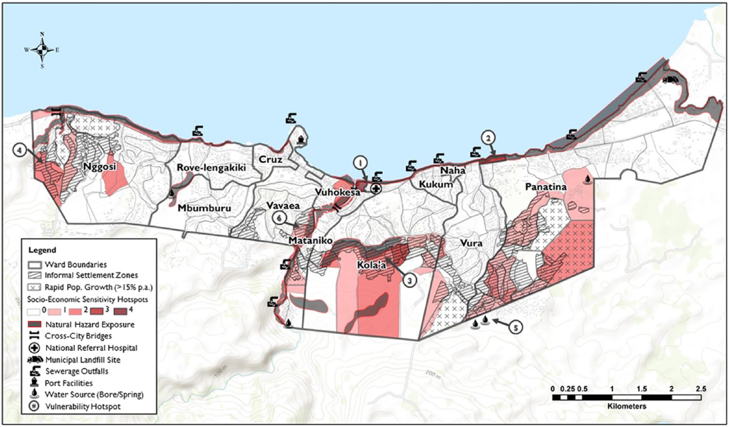
Honiara vulnerability model outputs
The use of spatial analysis of sub-city climate vulnerability in the HURCAP allowed the identification of three scales for participatory adaptation planning. Firstly, at a whole-of-city scale the exposure of key infrastructure – such as the unsealed, coastal landfill adjacent to the Lungga River to the city’s east – provided a platform for sectoral adaptation planning with expert stakeholders and institutional representatives.(53) Secondly, a ward-level scale provided a focal point for multi-stakeholder adaptation planning (including both institutional and community stakeholders from within each ward), as conducted through the Honiara Urban Resilience and Climate Adaptation Forum (discussed in Section III). Finally, and most critically, six climate vulnerability hotspot areas were identified for priority community-based adaptation action planning, built around endogenous sources of resilience and adaptive capacity.
A participatory, community-based approach to adaptation planning within these largely informal vulnerability hotspot areas could be argued to be necessitated by the lack of institutional capacity (as evidenced by the assessment of adaptive capacity shown in Figure 1) and infrastructure (visible in Map 3) within these zones. However, the presence of strong community networks, shared resourcing approaches, and locally adapted traditional knowledges and coping mechanisms also provided novel adaptation pathways that were otherwise unrecognized by formal institutional actors at city, sector-specific or ward scales. Despite the lack of direct engagement with city governance frameworks, adaptation planning at each level was guided by an overarching set of city objectives, ensuring alignment of values and strategic direction, even in localized, community-derived actions. This ability to understand efforts to build resilience as needing to operate at different scales – both spatially and temporally – helps to address trade-offs and conflicts in implementation, values and priorities.(54)
Similarly, in Port Vila the dependency on ecosystem services – ranging from timber collection for cooking fuels, to nearshore fishing, as well as extensive cultivation of “bush gardens” for both subsidence and production of small-scale cash crops – is illustrative of the importance of building resilience on informal capacities and resources that already exist in Pacific urban settings. As shown in Map 4, although the use of ecosystem services is more widespread in peri-urban areas and informal settlements, it also extends into Port Vila’s formal areas, both through direct use and through the purchasing of goods through informal markets across the city.
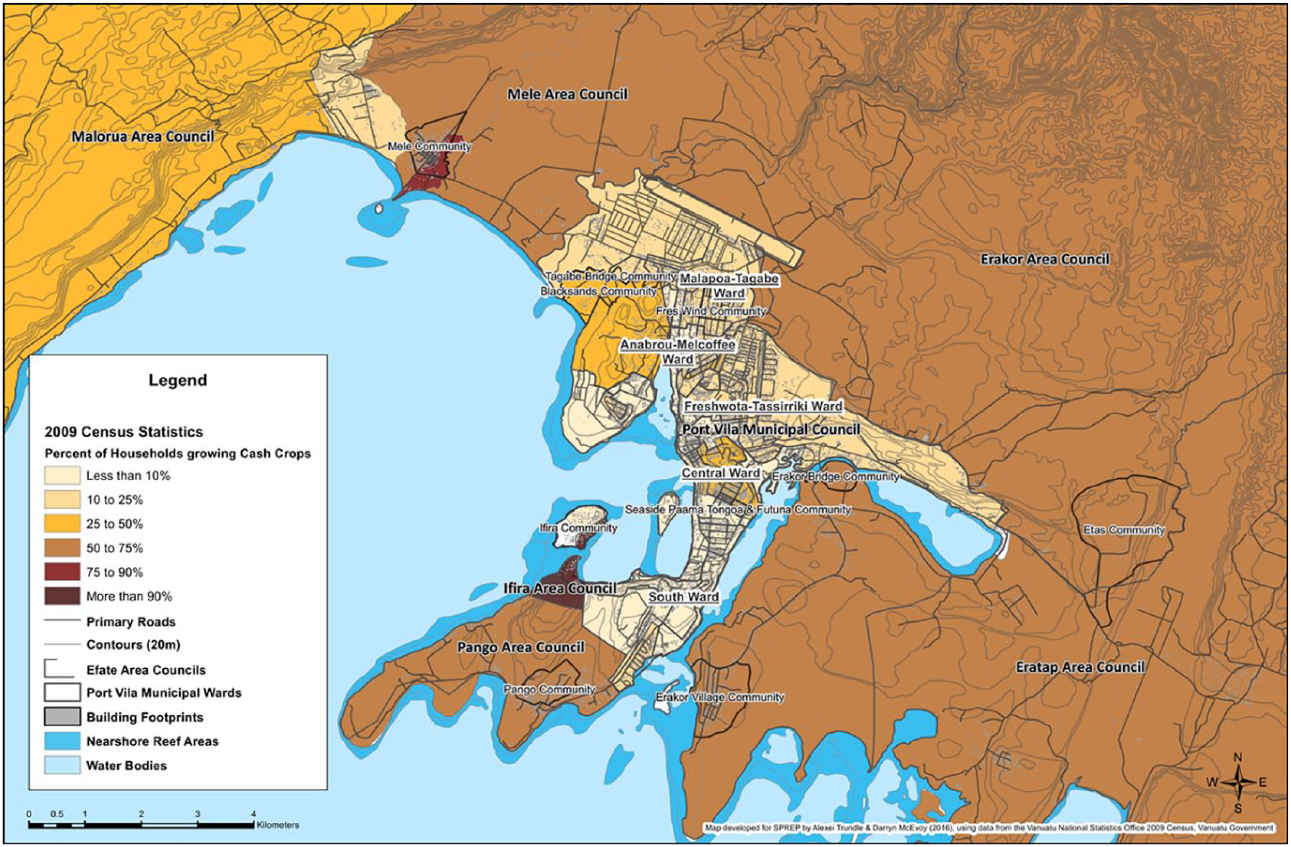
Production of cash crops by Greater Port Vila households
These “endogenous” modes of resilience not only operate outside of formal urban governance, but have the potential to be undermined by resilience initiatives that do not properly account for the critical role that they play in Pacific urban livelihoods.(55) This has been observed in informal settlements elsewhere, with Ziervogel et al. observing that resilience interventions “in addition to not equitably or inclusively accounting for differential interests [can] produce outcomes that further entrench vulnerabilities and socioeconomic impoverishment”.(56) Potential risks were demonstrable in both Honiara and Port Vila, with the encroachment of urban growth onto un-zoned bush garden areas undermining local food production. These bush gardens were a critical source of supplementary income and nutrition during the recovery from Tropical Cyclone Pam. Effective community-based climate adaptation, therefore, rests not only on the recognition of these often-undisclosed resource networks and capacities, but also on the management of the risks and uncertainties inherent in their interaction with the formal governance domain.(57)
VI. Lessons for A Global Urban Agenda for Climate Resilience and Sustainable Development
The third United Nations Conference on Housing and Sustainable Urban Development – known more commonly as Habitat III – represented an important milestone in establishing a global urban agenda for the 21st century, with the New Urban Agenda (NUA) providing a framework for guiding sustainable urban development over the two decades following the historic meeting in October 2016. Despite enshrining principles such as Lefebvre’s “Right to the City”, and integrating objectives of adaptation, resilience and low-carbon development, the extent to which the NUA represents a transformative departure from the functionalist norms that have driven 20th-century urban planning has been widely questioned.(58) Nonetheless, the recognition of cities as being necessarily part of the solution to sustainable global development – as embodied by Goal 11 in the 2030 Sustainable Development Agenda – is a notable shift from the problematized constructs of urbanization that underpinned Habitats I and II.(59)
The cities of the Pacific SIDS, which remain at the periphery of global capitalism, present a unique insight into alternative visions for sustainable urban development. While global development idealizes urban biophilia and ecological integration, sociocultural diversity, and community connectivity, Pacific small island developing cities – in the face of extreme disaster risk, economic isolation and geospatial constraints – encapsulate these qualities, while at the same time being characterized as failures of urban planning and governance.(60) The gradual onset of climate change impacts, however, is eroding these attributes. It is undermining traditional knowledge as seasons change, while accelerating rural-to-urban migration as low-lying areas become inundated or infertile, and subsistence resources become scarce as ecosystems collapse or shift state.(61)
A cautionary consideration, however, is needed in the application of global agendas for sustainable urban development in the Pacific, due to such frameworks being criticized for favouring institutional, city-scale interventions that can undermine the community-scale capacities set out in this paper. For instance, Ziervogel et al. posit that the resilience agenda has a “tendency not to account for the political – and inherently power-laden – structures that shape decision-making in local contexts”, making it “liable to capture by vested interest – at times the very same interest that have been instrumental in undermining resilience by creating unsustainable and unjust development”.(62)
These observations, while in reference to case studies elsewhere, are nonetheless consistent with the two Pacific case studies reflected on here. This is especially the case where informal and community structures are poorly understood – as demonstrated by the lack of awareness of community structures in Koa Hill, and the outdated figures and homogenous understanding of informal tenure arrangements and their occupants in Port Vila. Building directly on community-based priorities and decision-making processes provides an avenue for ensuring that these endogenous resilience attributes are not disrupted. However, the integration of these capacities with formal urban governance presents a more sustainable long-term pathway for sustainable urban development.
As Chelleri et al. observe, “responding to these sustainability challenges requires…an integrated framework for urban resilience that incorporates sustainability, and deals with cross-scale implications (trade-offs) among systems, capacities, vulnerabilities, and time periods”.(63) The consideration of differing values in resilience thinking is critical in socioecological systems, where objectives can diverge between stakeholder groups and scales. In particular, the exploration of the contributing factors in determining climate vulnerability in Port Vila and Honiara has demonstrated that a clearer understanding of the adaptive capacities of informal settlements, which largely operate independently of urban governance processes, is critical if vulnerability is to be reduced at a sub-city scale.
VII. Conclusions
Whilst making valuable contributions to the synthesis of scientific knowledge, previous IPCC assessments have been criticized from some quarters for disciplinary bias towards natural sciences and a disproportionate representation of authors from developed countries.(64) In addition, particular concerns were raised about the marginalization of “place-based” knowledge and a lack of consideration of indigenous knowledge in the run-up to AR5.(65) As argued by Kiddle et al., and reinforced by arguments made in this paper, accounting for the unique characteristics of Pacific SIDS – including making better use of endogenous resilience – is vital to support context-specific and appropriate adaptation of towns and cities in the region.(66)
With the discourse of Pacific Islands – particularly in the domain of international climate negotiations and finance – centred upon a narrative of climate vulnerability, it is notable that for the urban inhabitants of Pacific SIDS it is instead a perception of resilience in the face of a lengthy history of natural disasters that defines an emergent urban identity. If this is to be drawn on effectively, more nuanced considerations of this vulnerability – beyond simplistic applications of hazard exposure or rural–urban division – must form the basis of regional climate action. As such, it is important that the forthcoming 6th Assessment Report strikes a balance between physical and social sciences, as well as emphasizing the value of working with existing community structures and local governance frameworks.
In preparation for Habitat III, Pacific Island countries developed a New Pacific Urban Agenda, identifying the need to both advocate for and better understand the transformative role of cities in the region. One of its four pillars is “Environment, Resilience & Urbanisation”, which acknowledges the impact of climate change on urban systems as well as communities, and subsequently proposes integrated approaches to build resilience.(67) The next Pacific Urban Forum, planned for 2019, will further define regional action plans, including one that will draw on the lessons learnt with regard to participatory local climate action planning.
Footnotes
1.
2.
3.
Atteridge, Aaron and Nella Canales (2017), Climate Finance in the Pacific: An Overview of Flows to the Region, Stockholm, available at: ![]() .
.
4.
Nurse, Leonard A, Roger F McLean, John Agard Trinidad, Lino Pascal Briguglio, Virginie Duvat-Magnan, Netatua Pelesikoti, Emma Tompkins and Arthur Webb (2014), “Small islands”, Climate Change 2014: Impacts, Adaptation, and Vulnerability. Part B: Regional Aspects, Contribution of Working Group II to the Fifth Assessment Report of the Intergovernmental Panel on Climate Change, pages 1613–1654, available at ![]() .
.
5.
Rogelj, Joeri, Michiel Schaeffer, Malte Meinshausen, Reto Knutti, Joseph Alcamo, Keywan Riahi and William Hare (2015), “Zero emission targets as long-term global goals for climate protection”, Environmental Research Letters Vol 10, No 10, 10 pages; also UNDESA (2014), World Urbanization Prospects: 2014 Highlights, United Nations Department of Economic and Social Affairs, available at ![]() .
.
6.
Jones, Paul (2012), “Searching for a little bit of utopia – understanding the growth of squatter and informal settlements in Pacific towns and cities”, Australian Planner Vol 49, pages 327–338.
7.
Butcher-Gollach, Colleen (2015), “Planning, the urban poor and climate change in Small Island Developing States (SIDS): unmitigated disaster or inclusive adaptation?”, International Development Planning Review Vol 37, No 2, pages 225–248.
8.
9.
Ziervogel, Gina, Mark Pelling, Anton Cartwright, Eric Chu, Tanvi Deshpande, Leila Harris, Keith Hyams, Jean Kaunda, Benjamin Klaus, Kavya Michael, Lorena Pasquini, Robyn Pharoah, Lucy Rodina, Dianne Scott and Patricia Zweig (2017), “Inserting rights and justice into urban resilience: a focus on everyday risk”, Environment and Urbanization Vol 29, No 1, pages 123–138, page 133.
12.
UNDESA (2018), World Urbanization Prospects: The 2018 Revision, United Nations Department of Economic and Social Affairs, available at ![]() .
.
13.
14.
McDonnell, Siobhan, Mathew G Allen and Colin Filer (editors) (2017), Kastom, Property and Ideology - Land Transformations in Melanesia, 1st edition, ANU Press, Canberra, page 69, available at ![]() .
.
15.
16.
Trundle, Alexei (2017), “Governance and agency beyond boundaries: climate resilience in Port Vila’s peri-urban settlements”, in Susie Moloney, Hartmut Fünfgeld and Mikael Granberg (editors), Local Action on Climate Change: Opportunities & Constraints, 1st edition, Routledge, pages 35–52, available at ![]() .
.
17.
See reference 12.
18.
See reference 15; also see reference 16.
19.
20.
21.
Rawlings, Gregory E (1999), “Foundations of urbanisation: Port Vila Town and Pango Village, Vanuatu”, Oceania Vol 70, No 1, pages 72–86.
22.
Maggio, Rodolfo (2018), “According to kastom and according to law’: ‘good life’ and ‘good death’ in Gibert Camp, Solomon Islands”, in Chris Gregory and Jon Altman (editors), The Quest for the Good Life in Precarious Times - Ethnographic Perspectives on the Domestic Moral Economy, 1st edition, ANU Press, Canberra, pages 57–86.
23.
See reference 21.
24.
Haberkorn, Gerald (2008), “Pacific Islands population and development: facts, fictions and follies”, New Zealand Population Review Vols 33/34, pages 95–127.
25.
Moore, Clive (2015), “Honiara: arrival city and Pacific hybrid living space”, The Journal of Pacific History Vol 50, No 4, pages 419–436, page 430, available at ![]() .
.
26.
McDonnell, Siobhan (2013), “Exploring the cultural power of land law in Vanuatu: law as a performance that creates meaning and identities”, Intersections: Gender and Sexuality in Asia and the Pacific Vol 33, pages 1–17.
28.
Foukona, Joseph (2015), “Urban land in Honiara: strategies and rights to the city”, The Journal of Pacific History Vol 50, No 4, pages 504–518.
29.
See reference 28.
30.
Chung, Margaret and David Hill (2002), Urban Informal Settlements in Vanuatu: Challenge for Equitable Development, Port Vila, available at ![]() .
.
31.
32.
MIA (2012), Vanuatu Land Use Planning & Zoning Policy Re-Draft: Port Vila, Ministry of Internal Affairs, Port Vila, available at https://theredddesk.org/sites/default/files/Vanuatu%20Land%20Use%20Planning%20and%20Zoning%20Policy%20Draft.pdf; also Hollema, Siemon, Darryl Miller and Amy Chong (2015), Vanuatu: Cyclone Pam Impact Maps & Analysis, Port Vila, available at ![]() .
.
33.
Solomon Islands Government (2014), Rapid Assessment of the Macro and Sectoral Impacts of Flash Floods in the Solomon Islands, April 2014, Honiara, available at http://www-wds.worldbank.org/external/default/WDSContentServer/WDSP/IB/2015/04/15/000442464_20150415145011/Rendered/PDF/956390WP0P15091000PUBLIC00Box391423B0ACS.pdf; also World Bank (2015), Post-Disaster Needs Assessment: Tropical Cyclone Pam, page 172, available at ![]() .
.
34.
Kirch, Lotte, Stephan Luther, Peter Mucke, Ruben Prütz, Katrin Radtke and Christopher Schrader (2017) “WorldRiskIndex: A five-year perspective – Risk analysis 2012-2016”, in Lars Jeschonnek, Julia Walter, Lotte Kirch and Peter Mucke (editors), World Risk Report - Analysis and Prospects 2017, 1st edition, Bündnis Entwicklung Hilft Chausseestraße, Berlin, 56 pages, available at ![]() .
.
35.
36.
Adger, W Neil (2006), “Vulnerability”, Global Environmental Change Vol 16, No 3, pages 268–281.
37.
Rodil, Amillah S and Maria Adeliada Antonette Mias-Cea (2014), Honiara Climate Change Vulnerability Assessment - Abridged Report, in Maria Tomovic (editor), 1st edition, United Nations Human Settlements Programme, Nairobi, 45 pages.
39.
40.
McEvoy, Darryn, Naomi de Ville, Aimée Komugabe-Dixson and Alexei Trundle (2017), Great Port Vila Social Mapping and Analysis of Ecosystem Use, Scretariat of the Pacific Regional Environment Programme (SPREP), 90 pages.
41.
Downscaling is the process by which finer-resolution projections of global climate models are developed for a specific region. This involves either finer-resolution atmospheric climate models (dynamical downscaling) or the calibration of local conditions through the development of statistical understandings of local climate variables through high-quality observational data (statistical downscaling).
42.
See reference 16.
43.
See reference 39.
44.
Greenhouse gas concentration trajectories that represent differing levels of radiative forcing (expressed as an increase in watts per square metre measured in 2100, relative to pre-industrial levels).
45.
46.
See reference 39.
47.
Jones, Paul and David Sanderson (2017), “Urban resilience: informal and squatter settlements in the Pacific region”, The Development Bulletin Vol 78.
48.
Naha, Figure and Solomon Islands (2013), Honiara Sewerage System Preliminary Report, 45 pages.
49.
Solomon Islands Government (2011), “Report on 2009 Population & Housing Census”, Solomon Islands Government Statistical Bulletin Vol 6, available at ![]() .
.
50.
UN-Habitat (2003), The Challenge of Slums - Global Report on Human Settlements, Earthscan Publications on Behalf of UN-Habitat, 345 pages, available at ![]() .
.
51.
See reference 13.
52.
Usamah, Muhibuddin, John Handmer, David Mitchell and Iftekhar Ahmed (2014), “Can the vulnerable be resilient? Co-existence of vulnerability and disaster resilience: informal settlements in the Philippines”, International Journal of Disaster Risk Reduction Vol 10, pages 178–189.
53.
Ministry of Lands Housing & Survey (MLHS) and Honiara City Council (HCC) (2015), Honiara Local Planning Scheme 2015, Honiara, available at ![]() .
.
54.
Chelleri, Lorenzo, James J Waters, Marta Olazabal and Guido Minucci (2015), “Resilience trade-offs: addressing multiple scales and temporal aspects of urban resilience”, Environment and Urbanization Vol 27, No 1, pages 181–198.
55.
See reference 6.
56.
See reference 9, page 126.
57.
Dodman, David and Diana Mitlin (2013), “Challenges for community-based adaptation: discovering the potential for transformation”, Journal of International Development Vol 25, No 5, pages 640–659.
58.
Sassen, Saskia, Richard Sennett, Ricky Burdett and Joan Clos (2017), Toward an Open City: The Quito Papers and the New Urban Agenda, Routledge.
59.
Satterthwaite, David (2016), “Editorial: a new urban agenda?”, Environment and Urbanization Vol 28, No 1, pages 3–12.
60.
See reference 6.
61.
Campbell, John and Olivia Warrick (2014), Climate Change and Migration Issues in the Pacific, United Nations Economic and Social Commission for Asia and the Pacific.
62.
See reference 9, page 126.
63.
See reference 54, page 183.
64.
Hulme, Mike and Martin Mahony (2010), “Climate change: What do we know about the IPCC?”, Progress in Physical Geography Vol 34, No 5, pages 705–718.
65.
Ford, James D, Will Vanderbilt and Lea Berrang-Ford (2012), “Authorship in IPCC AR5 and its implications for content: climate change and Indigenous populations in WGII”, Climatic Change Vol 113, No 2, pages 201–213.
66.
Kiddle, Gabriel Luke, Darryn McEvoy, David Mitchell, Paul Jones and Sarah Mecartney (2017), “Unpacking the Pacific Urban Agenda: urban resilience challenges and opportunities”, Sustainability Vol 9, No 10, 15 pages.
67.
UN-Habitat (2015b), New Pacific Urban Agenda, 2015 Pacific Urban Forum, available at ![]() .
.