
Abstract
Much research has been carried out on the possible impacts of climate change for UK river flows. Catchment and national-scale studies since the early 1990s are here categorized into four modelling approaches: “top-down” GCM (Global Climate Model)-driven and probabilistic approaches and “bottom-up” stylised and scenario-neutral approaches. Early studies followed a stylised approach with a small number of model experiments focused on system sensitivity. GCM-driven approaches dominate since the mid-1990s and are scenario-led and “top-down”, but which incur the cascade of uncertainty which results in a large amount of information that may not be conducive to decision-making. The emergence of probabilistic projections aims to incorporate probabilistic information in navigating climate model uncertainty but remained “top-down” with challenges over its practical use for water resources planning. The scenario-neutral approach has clear roots in the early stylised approach with the aim to explore plausible futures beyond climate model projections and system sensitivity. A synthesis of studies employing each approach shows that the magnitude and sign of change in different hydrological variables remain uncertain between different regions of the UK. Comparison between studies is difficult due to their methodological differences and consequently different choices along the impact modelling chain, and with a notable geographic bias in catchment selection in southeast England. Major limitations for each approach include barriers to decision-making from wide uncertainty ranges, limited consideration of high-impact outcomes, and challenges in their application in water resources planning. These challenges represent priorities for future research using new “hybrid” approaches to produce complementary information to “top down” projections within a more “bottom-up” framework. Exploratory modelling, robust decision-making and storylines are examples of new approaches that have emerged. Key to the emerging approaches identified is a need to combine different modelling approaches to tackle different sources of uncertainty according to the intended aims of individual applications.
Introduction
Some of the most significant impacts of climate change are expected to manifest themselves through changes to the hydrological cycle. Changes in precipitation patterns influence both high and low river flows and alter the frequency and magnitude of hydro-meteorological hazards globally (Arnell and Gosling 2013). A substantial amount of research has taken place over the last three decades on the impacts of climate change for river flows and hydrological extremes in the UK. Studies have used different modelling techniques and approaches to assess the hydrological impacts of climate change. The breadth of this research has been enabled by the dense network of hydrological and hydrometric monitoring of UK river catchments, which is characterized by its data quality and length (Hannaford 2015). Projections using multiple generations of UK climate change scenarios show that there is broad agreement over a reduction in summer flows and a possible increase in winter flows, although this differs across different UK regions and the magnitude of change remains uncertain across different studies, regions and catchments (Arnell et al., 2015; Garner et al., 2017).
The latest evidence to inform the Third UK Climate Change Risk Assessment using the UK Climate Projections 2018 (UKCP18) suggests broadly that for the UK, the risks of both floods and droughts could increase under climate change, although not necessarily in the same locations. The latest probabilistic projections indicate high likelihood of an increase in the intensity and frequency of hydrological droughts, and water resources shortages under high emission scenarios are projected to impact the entire UK, not just the drier regions in southeast England (HR Wallingford 2020; Arnell et al., 2021). Similarly, river flood hazard, as represented by multiple indicators (e.g. 10-years flood and peak flows), could also increase across the UK with a larger magnitude of change across western areas (Arnell et al., 2021). Flood risk is also projected to increase under different adaptation scenarios of varying ambitions and the total number of people exposed is projected to be highest in northern England and Scotland (Sayers et al. 2020).
Despite a large body of literature, uncertainty remains over the magnitude of projected change in different hydrological variables for different parts of the UK by studies using a variety of climate model output and modelling approaches. This poses a significant challenge for flood risk management and water resources planning. Climate change impact assessments can be classified into two broad categories. The first is scenario-led and can be described as “top-down” and “science-first” according to guidelines developed by the Intergovernmental Panel on Climate Change (IPCC) (Jones et al., 2014). Within the “top-down” category, climate change scenarios describing different socio-economic pathways associated with different climate forcings are often used as input to GCMs or Earth System Models to generate climate change projections. Projections are then propagated through an impact modelling chain and choices made along the chain include the choice of emission scenarios, GCMs, hydrological models (and parameters), spatial downscaling approaches and risk indicators (Smith et al., 2018). Different sources of uncertainties are accrued and increase at every step to make up the “cascade of uncertainty” (Wilby and Dessai 2010). “Top-down” studies can be contrasted with “bottom-up” approaches which are not scenario-led and may be conducted independently from climate change scenarios often with greater involvement from stakeholders (Dessai et al., 2005). Some “bottom-up” approaches pay greater attention to system sensitivity (“sensitivity-led”) and others are motivated by assessing robustness of certain strategic plans over time (“policy-first”).
Stemming from evolving data availability and motivated by different ways to navigate the cascade of uncertainty, different “top-down” and “bottom-up” approaches have been used over the years. There is therefore merit in looking back at past studies to identify the approaches they took, their main contributions and the advantages and disadvantages behind each approach. In this review, we identify and compare modelling approaches of studies that investigate the impacts of climate change to UK river flows either at the catchment or national scale. There have been reviews of the potential impacts of climate change on hydrological variables for different regions of the UK (e.g. Arnell et al., 2015; Hannaford 2015; Watts et al., 2015; Garner et al., 2017). There have also been a number of reviews of the different downscaling and bias correction techniques available for hydrological modelling (e.g. Fowler et al., 2007; Teutschbein and Seibert, 2013). This review differs from the previous reviews because it places emphasis on the temporal development and main sources of evidence from different approaches. Although the review only focuses on studies investigating changes in UK river flows, the methodological approaches identified are also used elsewhere and the development of these approaches over time is likely to be similar in other contexts. The specific aims of this review are to: - Track the development of approaches over time and identify how the different approaches have dealt with the different sources of uncertainty - Identify the uptake, advantages and disadvantages of the approaches, including factors that may present possible barriers to decision-making - Identify emerging approaches that could be used to complement existing approaches for the provision of regional climate change information
Systematic literature search
Search criteria and search terms employed to retrieve relevant papers.
A total of 122 publications across 35 scientific journals were identified from 1990 to 2021 (the full list is available in the Supplementary Materials). Figure 1 shows the number of publications per year and their regional coverage based on the UK’s administrative region boundaries. Across the selected studies, 24 papers (20%) had a specific focus on droughts and 40 papers (33%) on floods. There is an uneven spatial coverage of the catchments considered in the identified publications. Catchments in southeast England were included most frequently, followed by catchments in Wales. In comparison, catchments in Northern Ireland were included least frequently. Additionally, studies have used a wide variety of hydrological models. The largest number of studies employed the PDM hydrological model followed by similar uptake across the CLASSIC, CATCHMOD and Grid-2-Grid models (inset Figure 1). Other hydrological models such as TOPMODEL have been widely used at UK catchments but have been used less often in climate change impact assessments. Out of the 122 publications, 63 (52%) made use of the downscaled UK regional climate change projections from the UK Climate Impacts Programme and Met Office with the remainder using either global or downscaled projections from different ensembles of climate models or an approach independent from climate model output. Number of identified peer reviewed publications per year since 1990 (n=122) and the top five most employed hydrological model across all publications (inset) (left). Percentage of total publications which included catchments in each administrative region of the UK (right).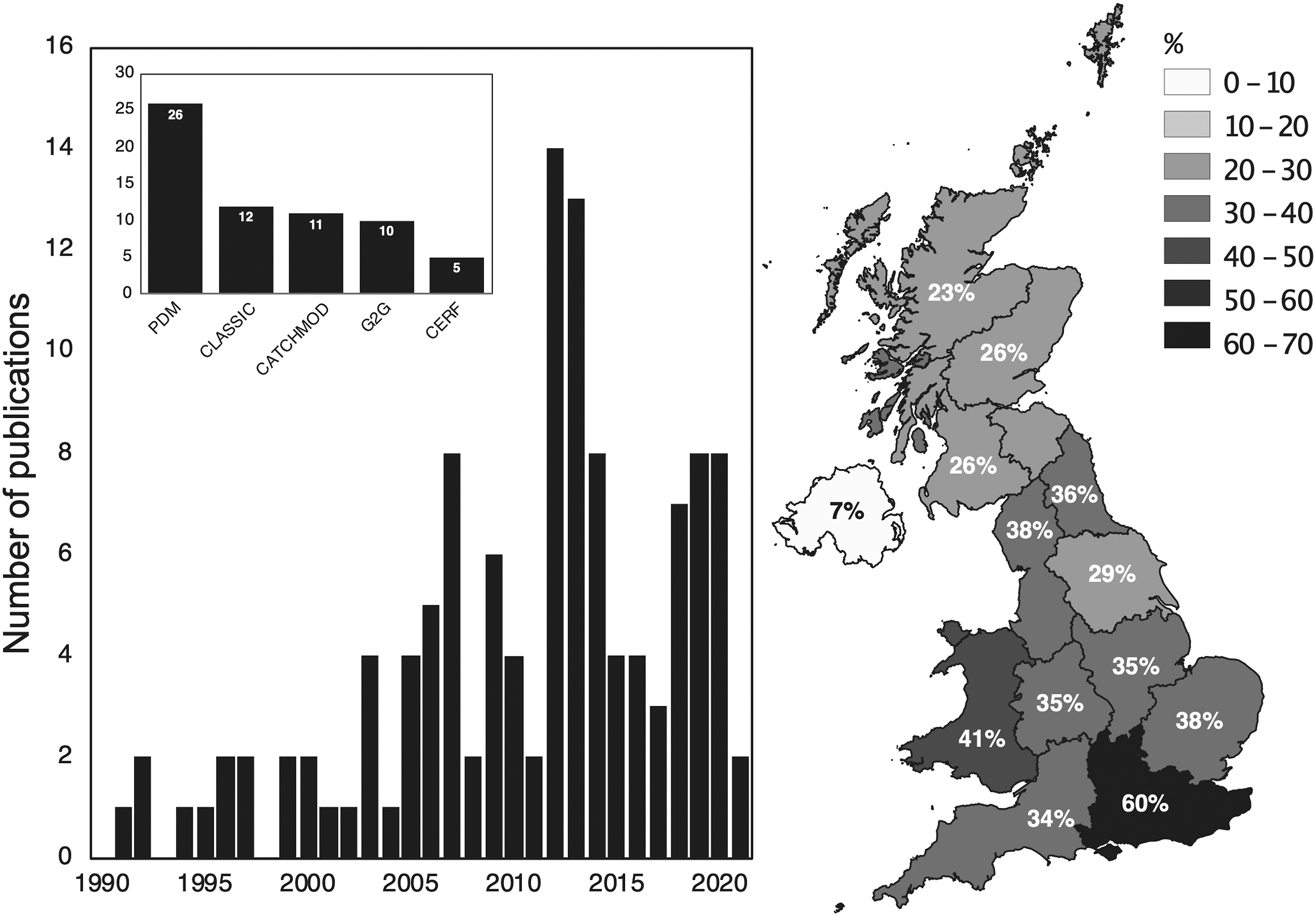
Development in modelling approaches
Four approaches to the development of climate scenarios can be identified from the reviewed publications. Approaches to study the hydrological impacts of climate change have developed over the past three decades from an initial very simple approach. These developments have occurred in terms of (i) the type and number of scenarios that are used, and (ii) the way the scenarios have been applied (Table 2). Different approaches have shared some of the same methods in applying climate change scenarios and the various methods have been developed to suit individual aims of the different approaches.
Approaches identified in the reviewed papers and methods used to apply climate change scenarios.

Figure 2 tracks the development of each approach over time and highlights seminal papers indicative of each approach. The following sections review the aims of each approach and the evidence and main contributions from selected studies. a) Modelling approach for each identified peer reviewed publication and b) Number of citations received for every publication. Representative publications for each modelling approach category and those which received over 300 citations are highlighted and coloured based on their modelling approach.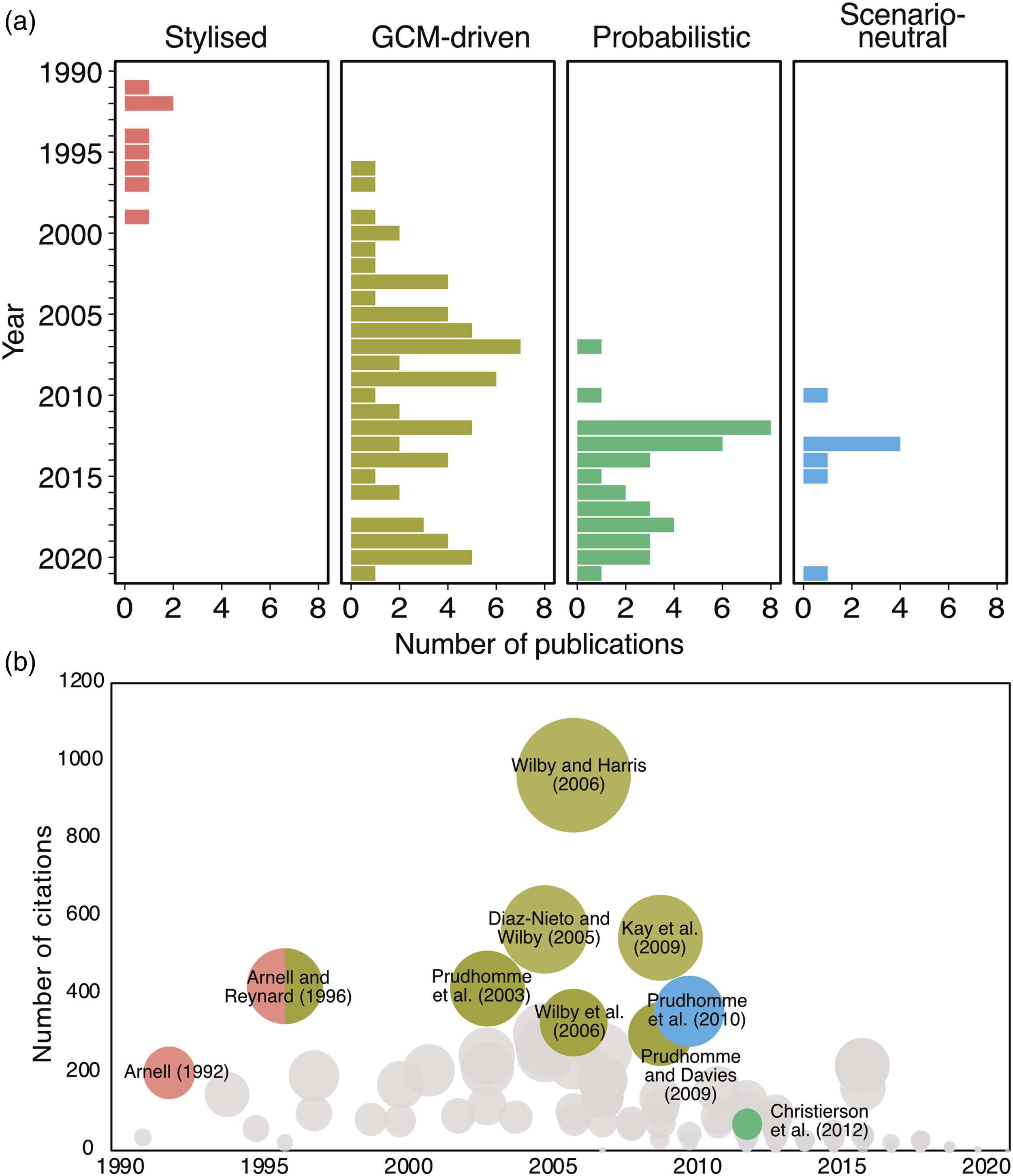
Stylised approach
The stylised approach stems from the limited number of GCMs and the coarse resolution of their output at the time. Stylised scenarios are separately defined for precipitation and temperature describing changes in monthly precipitation and potential evapotranspiration (PET) of various magnitudes at coarse spatial resolution. Relatively simple to apply with limited data requirements, stylised scenarios are particularly useful to understand and quantify plausible sensitivity ranges of individual catchments. The main contribution of the stylised approach is the understanding of hydrological system sensitivities across different UK regions and catchments.
Following the release of the first IPCC assessment report in 1990, Cole et al. (1991) and Arnell (1992a, b) were among the first published papers to investigate the impacts of climate change on UK river flows based on understanding at the time which suggested wetter winters and the possibility of drier summers. Cole et al. (1991) assessed changes to annual runoff and reservoir yield in contrasting regions of the UK (NW and SE. England) by perturbing precipitation and evaporation with seasonal mean changes to calculate annual runoff. They showed an overall 8% (4%) reduction in annual runoff for SE (NW) England with larger decreases in reservoir yields driven by an increase in evaporation. Similarly, Arnell (1992a, b) created seven stylised precipitation scenarios representing monthly and annual changes in precipitation made up by additional combinations of seasonal changes (e.g. 20% increase in all months or 15% decrease in summer). Applying different combinations of the stylised scenarios via a simple monthly water balance model, Arnell (1992a, b) showed that hydrological response to climatic change varies across different catchments. The results suggest particularly high sensitivity of annual and monthly river flow to how changes in precipitation are distributed across the year. For example, in fast responding northern catchments, reduction in summer precipitation has a significant (−35%) impact on summer river flows. In contrast, river flow response for lowland groundwater-dominated catchments during drier summers are determined by both catchment characteristics and the extent of increase in winter precipitation.
Later publications extended this approach to additional catchments with stylised scenarios constructed based on expert knowledge and process understanding gained from early climate models. An example are the precipitation scenarios in Arnell and Reynard (1996), created based on expert knowledge from the UK Climate Change Impacts Review Group representing “Wettest” (precipitation increase in all months by a large magnitude), “Driest” (precipitation reduction in all months with a larger reduction in summer) and “Best” (precipitation increase in all months except summer, where there is no change). Boorman and Sefton (1997) subsequently quantified the relative contribution from different sources of uncertainty through different stylised scenarios based on high-level national estimates of the UKHI and CCC climate models. They confirmed that changes in river flows varied between catchments with different physical characteristics but also between different hydrological models following the same stylised scenario. The largest magnitude of change in mean and low flows was projected for the groundwater-dominated catchment considered. The objective of quantifying different sources of uncertainty subsequently became a dominant feature of the GCM-driven studies that followed.
GCM-driven studies
Growth in computational resources and availability of GCM model output enabled the dominance of GCM-driven studies since the mid-1990s (81 papers, 65%). These studies use climate model output directly, most commonly projections developed and led by the UK Climate Impact Programme (UKCIP98, UKCIP02) and the Met Office (UKCP09, UKCP18). Figure 3 shows the use of the delta method, statistical and dynamical downscaling in the GCM-driven studies identified. First, the delta method, developed from the stylised approach, has been used consistently over the years. Most recently, the delta method has been used to apply dynamically downscaled regional climate models (RCMs) in the UKCP18 set of projections (Kay et al., 2021). This delta method preserves the temporal variability of the observed time series, which has been shown to be useful as it increases realism and familiarity to stakeholders (Watts et al., 2015; Arnell et al., 2021). Several GCM-driven studies have refined the delta method to include consideration of monthly variance for relative changes in wet and dry days and precipitation intensity (e.g. Reynard et al., 2001; Arnell 2003, 2011a). The majority of studies following this approach have created scenarios representing specific time periods to be compared with the present but a few have applied changes incrementally to create time series of evolving change (Arnell and Reynard 1996; Arnell et al., 2021; Kay et al., 2021). Development of approaches to generate climate change scenarios in GCM-driven studies for use in hydrological models.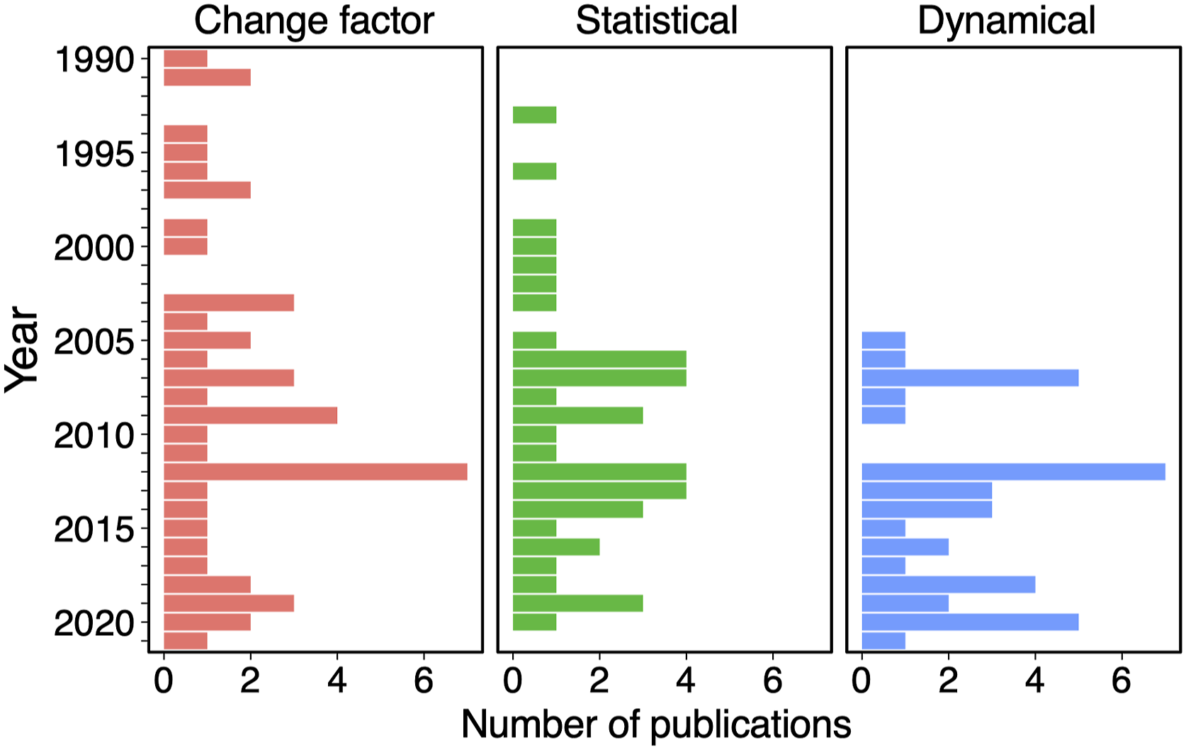
Second, bias correction and statistical downscaling techniques have also been used consistently alongside the delta method. Bias correction methods range from interpolation and area weighting of coarse GCM output to simple adjustments to the statistical moments of raw climate model output (e.g. Pilling and Jones 1999). More complex regression-based methods have been used based on atmospheric circulation or weather types (e.g. Wilby 2005; Wilby and Harris 2006; Prudhomme and Davies 2009). Stochastic weather generators have also been used and was a major part of the UKCP09 projections (e.g. Kay and Jones 2012; Harris et al., 2013; Afzal and Ragab 2020). Different statistical techniques correct for different kind of biases. In practice, it is often difficult to compare and validate the appropriateness of different techniques at multiple locations. Multiple statistical downscaling methods of varying complexities are therefore often used together before application in hydrological models (see Wilby et al., 2009 and Maraun et al., 2017 for details of different possible methods).
Third, the use of RCM output was motivated by the ability to incorporate finer region-specific attributes. In practice, RCM model outputs are often subjected to the same types of statistical bias adjustments as discussed above to correct for different biases (e.g., Cloke et al., 2010; Lafon et al., 2013; Kay et al., 2015; Pastén-Zapata et al., 2020). Studies have made use of the RCM outputs from multiple generations of the UK climate change projections (e.g., Bell et al., 2007; Kay et al., 2015; Rudd et al., 2020) and large ensemble experiments (e.g. weather@home: Guillod et al. 2018) to drive regional-scale hydrological models. Both statistical and dynamical downscaling enable continuous simulation of hydrological variables over time with greater consideration of natural variability and changes in wet/dry sequences.
Figure 4 presents a high-level summary of the direction of projected change in river flows across different regions of the UK based on GCM-driven studies. GCM-driven studies often take the form of multi-model and multi-method experiments to navigate the uncertainty cascade which has become the standard for climate change impact assessments. Outputs from different climate models from multi-model intercomparison projections (MIPs) (e.g. CMIP3 and CMIP5) are often used to consider climate model uncertainty. Different emission scenarios, downscaling methods, and hydrological models are also considered with an aim to comprehensively analyse as large a number of uncertainty sources as possible. Successive studies comparing different sources of uncertainty along the impact modelling chain at different UK catchments show that GCM-related uncertainty is generally the largest source of uncertainty with differences in both sign and magnitude of projected change although there is greater agreement among the selected GCMs over a reduction in summer flows, particularly for catchments in southern England (e.g. Prudhomme et al., 2003; Wilby and Harris 2006; Prudhomme and Davies 2009; Kay et al., 2009; Arnell 2011a). The relative significance of different sources of uncertainty also varies with the time horizon considered. Uncertainty in the near-term (2020s) is associated with natural climate variability while climate model and emission scenario uncertainty dominate in the mid- (2050s) and long-term (2080s) (Hawkins and Sutton 2011). An additional source of GCM-related uncertainty is natural climate variability which is often overlooked in hydrological climate change impact assessments but can have a large impact on the magnitude of projected change in river flows as demonstrated by Ledbetter et al. (2012) using a statistical resampling procedure applied to GCM model output. High level summary of the hydrological impacts of climate change from studies employing a GCM-driven approach. Refer to Supplemental Table S1 for the corresponding citation to each reference index.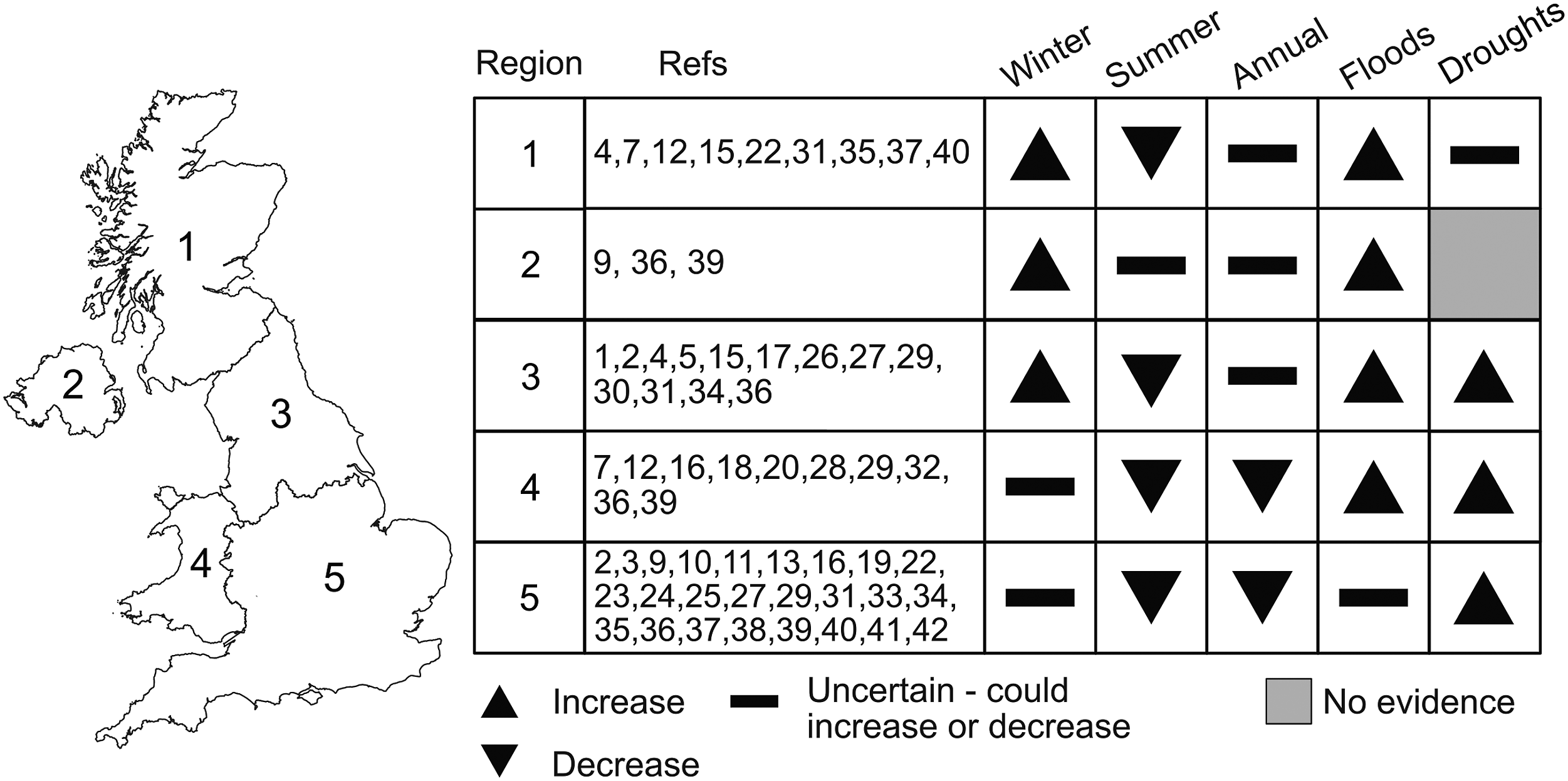
Additional sources of uncertainty form the cascade of uncertainty in GCM-driven studies. This includes uncertainty from different hydrological model structures particularly when considering intensity, frequency, and duration of hydrological extremes (Kay et al., 2009; Visser-Quinn et al., 2019) and the choice of hydrological indices for evaluating impacts (Ekström et al. 2018). Parameter uncertainty was also found to be particularly important for periods of low flows (Wilby and Harris 2006; Arnell 2011a). Comparing different statistical downscaling techniques, Diaz-Nieto and Wilby (2005) concluded that although different techniques agree on a reduction in the magnitude of low flows for the River Thames, the change factor method projects a larger reduction in all months compared to more conservative changes projected using statistically downscaled data. The use of downscaled data at different spatial resolutions adds to the GCM-related uncertainty and increases overall uncertainty (Orr et al., 2021). Kay et al. (2015) and Rudd et al. (2020) both found that the magnitude of change in increased peak flows can vary between the 1.5 km and 12 km RCM data in different regions of the UK (e.g. East England) with largest uncertainty for projected changes in winter and spring.
Probabilistic approach
UKCP09 was the first generation of UK climate change projections to provide probabilistic information (Murphy et al. 2009). Prior to UKCP09, climateprediction.net (CPDN) was the first to produce probabilistic projections and has been used in several studies to assess potential changes in UK river flows (e.g. New et al., 2007; Lopez et al. 2009; Fung et al., 2013). The probabilistic strands of UKCP09 and later UKCP18 consist of, respectively 10,000 and 3000 equally plausible climate scenarios constructed using a statistical emulator tuned to GCMs representing both uncertainty in climate model (structural uncertainty) and parameterization parameter uncertainty, as characterized by perturbed-physics ensembles (PPE) of climate models. 25 of the reviewed papers have used the UKCP09 or UKCP18 probabilistic projections. The probabilistic projections are presented as monthly changes in weather variables, so have been applied using the delta method. The UKCP09 probabilistic projections can also be explored using the stochastic weather generator provided. Note that both UKCP09 and UKCP18 include projections based on individual GCMs and RCMs and studies employing data from these projections are considered GCM-driven studies, as covered in GCM-driven studies.
Figure 5 provides a high-level summary of projected change in river flows from studies employing probabilistic projections. The first use of the UKCP09 probabilistic projections was Kay and Jones (2012) which compared results using the different UKCP09 strands (probabilistic change factors, weather generator and RCM) at nine UK catchments. Using all 10,000 sets of probabilistic change factors and 100 sets of weather generator data, the study showed that most of the change factors point towards an increase in flood peaks with a 20-years return period except for selected catchments in Southern England which exhibited greater uncertainty in the sign of change. Although mean projected change is similar across the UKCP09 strands, the authors cautioned against the use of a single strand as the uncertainty range of the probabilistic change factors did not always incorporate the uncertainty range of the other strands. Christierson et al. (2012) was the first to present national scale projections of flow changes at 70 catchments for different probability percentiles. For the 50th percentile, the study found a reduction in summer flows across the UK, particularly southern England. There was greater uncertainty over changes in winter with enhanced flow seasonality and increased winter flows more prevalent in northern catchments (also found in Thompson 2012 for Scotland). Changes for spring and autumn are smaller with catchments in southern England projected to experience a reduction in flows in all seasons. Despite wetter winters projected for northern catchments, studies have also highlighted an increase in future drought severity for the central estimate mainly due to lower summer flows and higher evaporative demand (Afzal et al., 2015; Afzal and Ragab 2020). Using all 10,000 change factors may not be computationally feasible in practice. Christierson et al. (2012) found that a subset of 20 change factors is enough to capture climate model uncertainty, but the appropriate sample size is likely to differ for more extreme quantiles to understand uncertainty in projected change for hydrological extremes (Charlton and Arnell 2014). High level summary of the hydrological impacts of climate change from studies employing a probabilistic approach. Refer to Supplemental Table S2 for the corresponding citation to each reference index.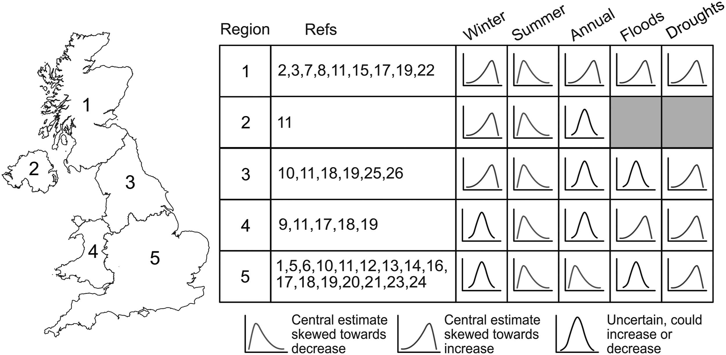
Probabilistic projections enable the adoption of what has been termed a “risk-based” approach in water resources planning. The large sample size from the probabilistic change factor sample sets and the UKCP09 stochastic weather generator allow for the generation of probability distributions to characterize the likelihood of projected changes exceeding certain thresholds (Hall et al., 2020; Borgomeo et al., 2014; Harris et al., 2013; Reynard et al., 2017). For example, Manning et al. (2009) employed a probabilistic approach with synthetic data generated from a stochastic weather generator to investigate the probability of exceeding water shortage thresholds for the River Thames in the 2050s and 2080s in accordance with current abstraction strategies. Similarly, Borgomeo et al. (2014) updated the risk of water shortages by using a weather generator fed with the UKCP09 probabilistic change factors. The authors found that the climate change and population growth are likely to increase the probability of water shortage risk (failure to meet Level of Service for water shortage; the frequency of water use restrictions) even with demand and supply management measures. While studies have demonstrated the use of this approach in a number of catchments, the uptake of probabilistic projections in practice is challenging and limited by issues such as the treatment of uncertainties and spatial coherence which is further discussed in Methodological limitations.
Scenario-neutral
The scenario-neutral (S-N) approach, first presented in Prudhomme et al. (2010), aims to invert the scenario-led, GCM-driven approach. Hydrological response from incremental changes in two user-defined dimensions are visualized on a response surface. The use of this approach in Prudhomme et al. (2010) was motivated by the need to consider changes beyond GCM projections and to explicitly consider system sensitivity against current guidance on climate change allowances for flood risk management. The scenario-neutral approach has since been used for different hydrological variables (e.g. peak flows – Prudhomme et al., 2013a, 2013b; Kay et al., 2014a and low flows – Prudhomme et al., 2015). In Prudhomme et al. (2010), response surfaces were constructed for 20-years flood peaks from incremental percentage changes in mean annual precipitation and seasonal precipitation variation. Results from different studies following the S-N approach confirmed the important role of precipitation seasonality in projected change in future floods and droughts on a national scale, as had been demonstrated in small subsets of UK catchments in earlier studies following the stylised approach.
The methodological framework of the S-N approach echoes the early stylised approach carried out two decades prior. It also has clear roots in early sensitivity experiments such as the “sensitivity surfaces” constructed in Arnell (1996) for a small number of UK catchments and that of Ně mec and Schaake (1982) for the Pease River, USA which was one of the first published studies to assess the impacts of climate change on river flows. Like the stylised approaches, studies are not directly driven and constrained by GCM model output. The S-N approach also quantifies hydrological response at finer increments rather than the discrete experiments in the stylised approach with the ability to consider dimensions beyond just changes in monthly means. Constructing response surfaces at a national scale for 154 catchments, Prudhomme et al. (2013a, 2013b) and Kay et al. (2014) defined nine flood sensitivity types for the UK by grouping flood peak response surfaces by signal and magnitude of change. Results from the flood sensitivity types further highlight differences in sensitivity to climatic change between different types of catchments, with certain sensitivity types more uncertain to future changes in peak flows (such as more variable and uncertain response at drier and slow-responding catchments in SE. England).
The ability to integrate GCM-driven and probabilistic approaches by overlaying projected changes from climate models or probabilistic outputs on the response surfaces further differentiates the S-N approach from previous approaches. Prudhomme et al. (2010) overlaid projected change from 46 GCMs on response surfaces of 20 years flood peaks to understand the validity of the widely used climate change allowance of +20% in flood peaks. The authors found that a considerable proportion of GCM projections match and exceed the allowance threshold and that a small deviation from some of the GCM projections would result in further increases in flood peaks beyond the allowance. Kay et al. (2014) subsequently combined the probabilistic projections from the full UKCP09 change factor set with S-N response surfaces. In this case, climate change allowances are revised on a catchment and regional basis by exploring the uncertainty range of the probabilistic projections within a “sensitivity-led” response surface framework for different flood sensitivity types (Kay et al., 2011; Reynard et al., 2017)
Discussion
Methodological limitations
Advantages and disadvantages of the modelling approaches identified from peer reviewed literature since 1990s and examples of their use in water resources management.
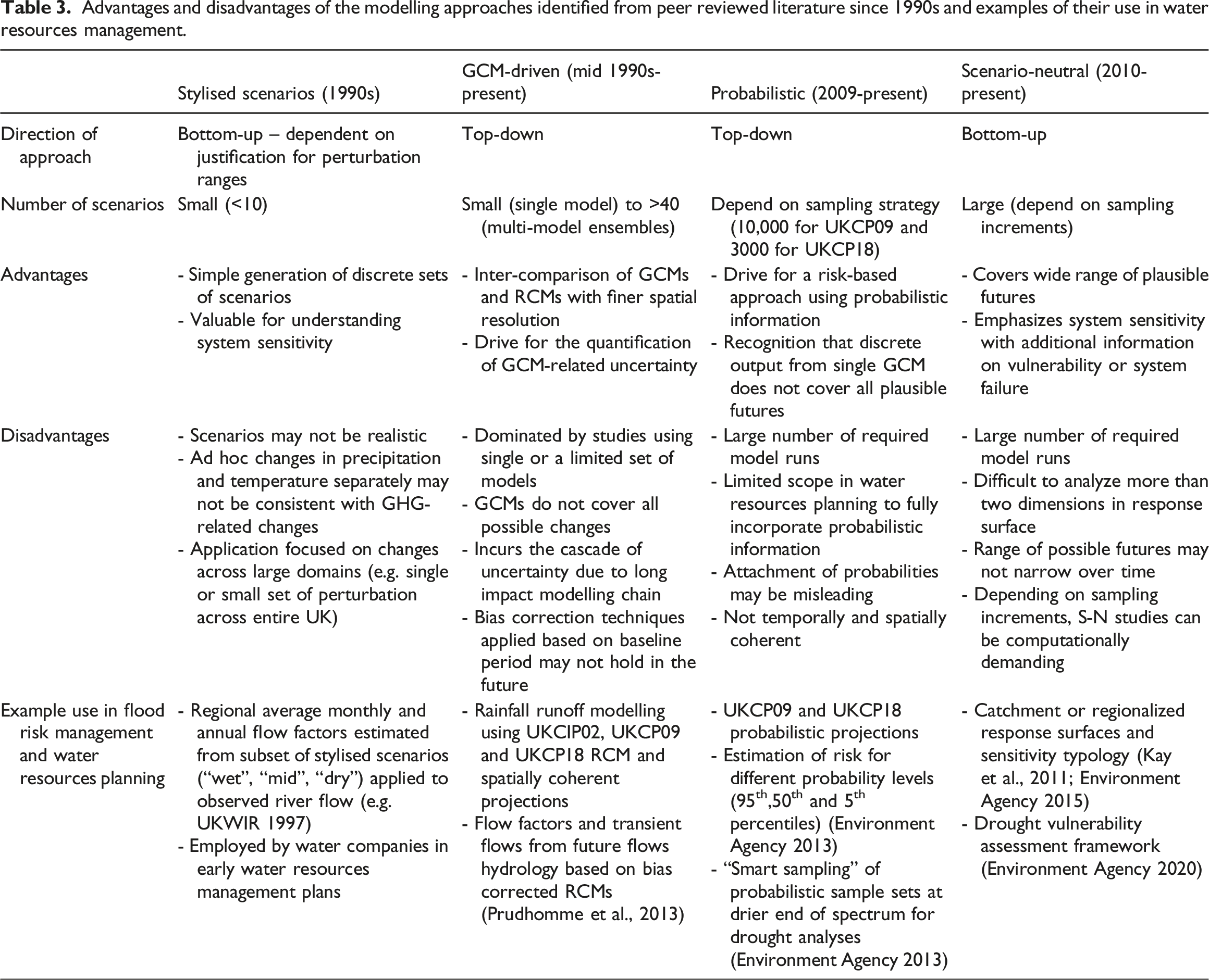
Each methodological approach is subject to several drawbacks. The number of scenarios (and model runs) required by studies following the different approaches can differ considerably. This ranges from the small number of discrete perturbations in the stylised approach to subsets (or full range) of climate models in GCM-driven studies and many possible simulations in both the probabilistic and scenario-neutral approaches. Although simple to apply, the stylised approach preserves the temporal variability of the observed time series as a single set of ad-hoc monthly perturbations are applied to observed data. The plausibility of such changes or combination of changes are difficult to verify with limited consideration of spatial variation. The scenario-neutral approach, which can be seen as a development from the stylised approach, is designed as a screening tool, and further detailed studies of individual “futures” within the response surface are still needed for adaptation and water resources planning (Prudhomme et al., 2015). Additionally, multiple or combined response surfaces are required if more than two dimensions (e.g. derived variables such as aridity) are considered at any one time which increases computational time and may potentially be confusing for practical use. Recent research also highlighted additional uncertainty from the wide variety of methods used to populate the response surfaces and the different choices of decision- or system-relevant impact variables (Keller et al. 2019; Culley et al., 2019). Another challenge is to define the boundaries over which the response surface is constructed: using climate model projections helps identify a “plausible” range.
GCM-driven studies often aim to comprehensively analyze as many sources of uncertainty as possible. The lengthening of the cascade of uncertainty has led to what has been termed “ensemble fatigue” (Benestad et al., 2017) where choices made along the impact modelling chain results in an abundance of available information and wide uncertainty ranges. Even the most comprehensive study cannot fully analyze all sources of uncertainty and choices made along the impact modelling chain are often made by the modellers instead of the decision-makers (Smith et al., 2018). Additional uncertainty is introduced from “method uncertainty” characterized by differences in the experimental setups of different MIPs particularly for projections for changes in precipitation and patterns of drying (Uhe et al., 2021). The need for analyses to be repeated whenever new projections are published means that the subsequent uncertainty range may become larger with successive generations of climate change projections. This characterizes a “predict-then-manage” philosophy where decisions may be made from a single or few projections and represented through an ensemble mean, which may be both inaccurate and implausible (Arnell 2011a; Smith et al., 2018; Løhre et al., 2019).
Probabilistic projections explore a larger range of plausible futures and in principle can represent different sources of uncertainty. However, the range of plausible futures depends on choices made about what sources of uncertainty to include and which sources of information to use – such as which climate models are used. For example, GCM-related uncertainty (e.g. via precipitation changes) mainly stems from uncertainty in the atmospheric circulation response to climate change between different climate models (Shepherd 2014). The estimated probability distribution is therefore not an objective estimate of the likelihood of some climate outcome (Arnell 2011b; Beven 2011). The novel treatment of climate model uncertainty in the UKCP09 probabilistic projections is largely the result of a science-led process. The assumption was made that capturing (or estimating) the full range of model uncertainty would lead to better decision-making. However, scientists’ perceptions of user needs and actual user needs may differ (Skelton et al., 2017; Porter and Dessai 2017). Current UK probabilistic projections are also not spatially coherent and cannot be used to analyze the spatial extent of hydrological extremes across multiple catchments, an often-neglected aspect in current studies (Brunner et al., 2021). Decision-makers could find it difficult to interpret probabilistic information as they may be unaware of the underlying assumptions and uncertainty when generating probability distributions. Although the inclusion of probabilistic information may be seen as more scientifically accurate with wider uncertainty ranges (i.e. more likely to include the actual outcome), probabilistic projections may be perceived as being less informative (i.e. lower level of precision) and therefore less useful for decision-making (Løhre et al., 2019).
Implications of methodological approaches
High-level summaries of projected change from the different approaches show good agreement over the general direction of changes projected for different regions of the UK and between catchments with different characteristics (e.g. slow vs fast-responding catchments). However, detailed comparisons of the magnitude of change are difficult due to the inconsistent and uneven selection of emission scenarios, catchments, hydrological models and variables (and indicators) between different studies. This inconsistency mainly arises from different methodological aims of the different approaches. For example, studies following stylised and S-N approaches may be able to focus on many catchments due to their relatively simple perturbations. Conversely, GCM-driven studies may choose to comprehensively analyze a single source of uncertainty (e.g. using climate model ensembles or multiple hydrological models) but may only be able to select a few catchments and may not be able to comprehensively analyze other sources of uncertainties. Consequently, the studies reviewed show an unequal geographical spread with certain regions (or catchments) that are studied more often than others (e.g. SE. England). Studies are also dominated by a few hydrological models which can limit our understanding of the heterogeneity of hydrological behaviour and their responses to climate change. Recent advances to tackle this include flexible, modular modelling frameworks (e.g. Lane et al., 2019) and improvements to national-scale gridded hydrological models (e.g. inclusion of abstraction processes: Rameshwaran et al. 2022).
Figure 6 shows the uneven use of emission scenarios and future time period in studies using different generations of UK climate change projections. The largest number of studies using UKCIP02 and UKCP09 products focused on the medium emissions pathway. A previous synthesis by Gawith et al. (2009) found that users often saw the medium scenario as the “middle road” or “safe” choice. In practice, water companies rely on the medium scenario for estimates of climate change effects on water supply and use the high and low scenarios to incorporate uncertainty through a target headroom – a buffer to be maintained between water supply and demand (Environment Agency 2013). In contrast to this, GCM-driven studies disproportionately employed the highest emissions RCP8.5 pathway. This was also identified in O’Neill et al. (2020) where the greatest number of studies globally across different sectors used RCP8.5. Some have contested that the use of RCP8.5 could be misleading, especially if interpreted – incorrectly – as a “business as usual” scenario (Hausfather and Peters 2020). However, its use in practice is often because RCP8.5 has the strongest climate change signal and because it often has the most information available (e.g spatial coherence). Recent studies have demonstrated that other sources of information could be more suited for decision-making such as quantifying the impacts avoided from lower emission pathways or from mitigation strategies and policy targets (Arnell et al., 2014; Orr et al., 2021). Even though probabilistic projections are designed to tackle a wider range of climate model uncertainty, a number of studies have used and reported only the central estimate (i.e. 50th probability level) of the UKCP09 probabilistic projections. Adaptation and management measures based on the studies reviewed may therefore require further information on low-likelihood outcomes to reduce the risk of maladaptation where findings could be overly cautious and optimistic (Harris et al., 2013, 2014). Percentage of total publications using each emission scenario from UKCIP02, UKCP09, IPCC SRES and RCP climate change scenarios. Inset plot shows percentage of total publications considering the three most commonly used future time slice (2020s, 2050s and 2080s).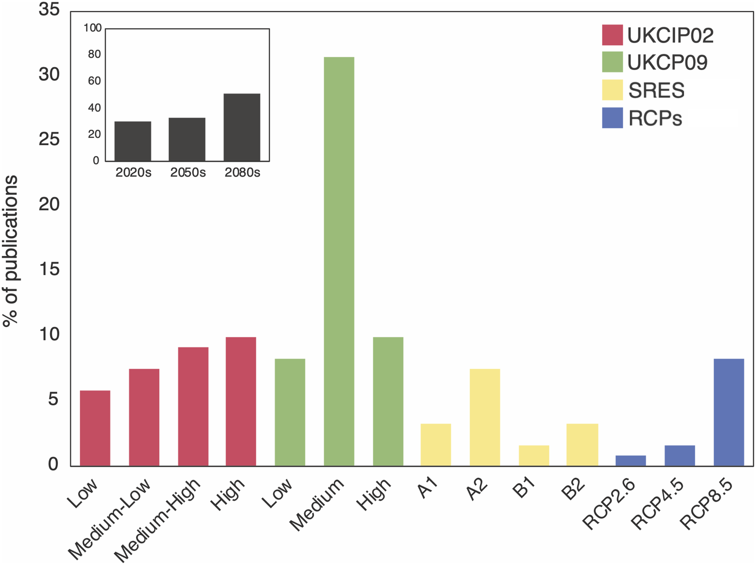
Emerging approaches
The above synthesis highlights the limitations of existing approaches and shows that the methodological differences between the approaches present a challenge to fully understand the hydrological impacts of climate change. Ensuring adopted approaches are able to provide meaningful information for decision-making emerge as a key research priority. Emerging research areas include understanding the processes and pathways of low-likelihood, high-impact hydrological extremes, increased focus on policy-relevant outcomes and the application of various approaches in practical water resources planning. These research areas complement the challenges identified in Brunner et al. (2021) to study droughts and floods in a joint framework and to consider high-impact compound events and their drivers. Future research could draw on a combination of existing approaches and emerging approaches outlined in this section in a pluralistic and complementary way such that different approaches may be used for different purposes according to the aims of individual applications.
Alternative ways have been proposed to extract additional information from the cascade of uncertainty. Smith et al. (2018) identified three different strategies to characterize uncertainty: 1) Analyze, 2) Bound and 3) Crystallize. GCM-driven studies identified in this review tend to fall within the first strategy as their aim is to analyze as many sources of uncertainty as possible. The latter two strategies require a more focused investigation by presenting the upper and lower bounds or by searching for specific outcomes within the uncertainty cascade. Both strategies may be able to better consider plausible worst cases and high-impact, low-likelihood events (Sutton 2019; Arnell et al., 2021). An example of this is the H++ climate change scenarios, which created high-impact scenarios for high/low river flows, floods and droughts. The high-end scenarios were created by combining multiple lines of evidence (e.g. process understanding, historical observations, paleo-climate analogues and GCM projections) to define physical limits of plausible worst-case scenarios beyond the upper uncertainty range of GCM projections (Wade et al. 2015). Similarly, the UNprecedented Simulation of Extremes with ENsembles (UNSEEN) approach aims to characterize low likelihood extreme events using retrospective forecasts or large ensemble climate model data to search for events which are beyond the observed record (Thompson et al., 2017; Kelder et al., 2020). Borgomeo et al. (2015) and Brunner and Tallaksen (2019) are also examples of this strategy where the sample size is increased through direct stochastic simulation of synthetic river flows in order to robustly assess the probability of severe droughts at UK catchments.
Circulation-related uncertainty across GCMs means that plausible high-impact outcomes beyond GCM projections, particularly those related to the sequencing and clustering of meteorological variables, may not be adequately considered (e.g.for droughts; Moon et al., 2018). Recent proposals have suggested creating “tales” or “physical climate storylines” to tackle this (Hazeleger et al., 2015; Shepherd et al., 2018). Storylines are plausible pathways conditional on a discrete set of changes (e.g. atmospheric circulation, management measures and event characteristics) which could lead to high impacts (Shepherd et al., 2018). Rather than aggregating dissimilar hydrological events as in most of the reviewed studies, an event storyline can consider plausible present day and future outcomes with an in-depth investigation of processes responsible for individual events (Lloyd and Shepherd 2020; Brunner et al., 2021; Sillmann et al., 2021; Van der Wiel et al., 2021; Doblas-Reyes et al., 2021). Individual studies can decide which source(s) of uncertainty to focus on and analyze at what level of detail to navigate the uncertainty cascade in a way which best supports decision-making. This complements recent proposals to take a downward counterfactual or stress test approach to reimagine how observed events could have turned out worse (“near misses”) (Stoelzle et al., 2020; Lin et al. 2020; Woo 2021). Taking the example of the 1975-76 UK drought, a short-lived but extremely severe drought, Woo (2021) imagined downward counterfactuals based on how prevailing meteorological conditions at the time could have resulted in even worse impacts (e.g. what if the northerly jet stream persisted longer than observed). Similarly, Chan et al. (2021) created counterfactual event storylines to quantify how much worse the 2010-12 UK drought could have been if it was preceded by drier preconditions or followed by a plausible third dry winter. These approaches make use of traditional “top-down” scenarios in novel ways and could be particularly useful to satisfy requirements in water resources planning such as assessing resilience to one in 500-years droughts for which there are no historical observations.
Other approaches could mitigate the drawbacks of top-down approaches in an outcome- and stakeholder-oriented context by investigating the validity of management measures in response to “what-if” situations (Maier et al., 2016). One of the earliest application of “what-if” experiments in the UK is Whitehead et al. (2006) where a water quality model was used to test different adaptation strategies (e.g. land use change, reduced fertilization) against water quality outcomes for the River Kennett in southern UK. In a recent evaluation of flood estimation guidance, Wasko et al. (2021) suggested a move towards ‘robust’ and ‘adaptive’ approaches to decision-making to complement GCM-driven and probabilistic studies. This includes the Robust Decision Making (RDM) approach and adaptation pathways. RDM aims to assess the performance of alternative strategies and collaborate with decision-makers to define an envelope of outcomes of which particular strategies can achieve favourable outcomes (Hall et al., 2012; Dessai and Darch 2014; Workman et al., 2021). Adaptation pathways are sequences of different combinations of management measures over time that are adjustable in light of future warming and impacts (Haasnoot et al., 2013).
Recently, the RDM framework has been used to stress test different supply and demand options to identify acceptable mixes of management measures at the Thames Basin that are resilient to a past severe drought, satisfy financial goals and meet future service targets (Matrosov et al., 2015; Huskova et al., 2016). The framework has also been used to assess alternative measures for flood risk management in collaboration with water companies at the Trent catchment (Hine and Hall 2010) and to identify the robustness of various supply and demand-side management strategies in relation to reservoir storage risk in Cornwall (Korteling et al. 2013). Reviewing the uptake of RDM principles in UK water resources planning, Dessai and Darch (2014) showed that the adoption of sensitivity-led frameworks is indicative of the increasing influence of RDM principles in practice, and that overcoming challenges such as computational resources and the “predict-then-manage” philosophy in the water resources industry could enable a fuller adoption of RDM principles.
Conclusions
This review has identified 122 papers investigating the hydrological impacts of climate change in the UK from the 1990s to 2021. Four modelling approaches were identified from the reviewed papers. A GCM-driven, “top-down” approach is the most widely adopted approach to date but alternatives are emerging as the limitations of top-down approaches become more widely recognized. GCM-driven studies are often characterized by an aim to quantify the relative contribution of different sources of uncertainty using multiple methods to apply climate change scenarios, showing that circulation-related uncertainty between different GCMs is the dominant source of uncertainty. However, they incur the cascade of uncertainty which results in a large amount of information that may not be conducive to decision-making. Probabilistic approaches provide an alternative way to treat climate-model uncertainty through advances in perturbed physics ensembles. However, they are still “top-down” with outstanding challenges related to their practical use in water resources planning. The scenario-neutral approach echoes the earliest stylised approach with a “bottom-up” focus on system sensitivity and more explicit consideration of how results can be informative from a decision-making perspective. Both approaches have contributed to the fundamental understanding of how different types of hydrological systems respond to a wide range of climatic changes.
Synthesis of studies employing each approach shows that the magnitude and sign of change in different hydrological variables remain uncertain between different regions of the UK. High-level summaries of projected change in river flows do not significantly differ between the approaches although direct comparisons between studies following different approaches are difficult and limited due to their methodological differences and consequently different choices made along the impact modelling chain (e.g. catchments, emission scenarios and hydrological models). Major limitations across the different approaches include issues related to wide uncertainty ranges, limited consideration of high-impact outcomes and practical challenges in their use in water resources planning. Exploratory modelling, robust decision-making and storylines of extreme events are examples of new approaches identified to explore worst-case scenarios and link management decisions to a wider range of plausible outcomes. These new approaches can be considered as “hybrid” or “pluralistic” where different techniques complement each other and “top-down” projections can be explored within a wider “bottom-up” framework led by the intended aims of specific applications. They aim to circumvent and navigate aspects of the uncertainty cascade in different ways to provide additional lines of evidence in future climate change impact assessments.
Supplemental Material
sj-pdf-1-ppg-10.1177_03091333221079201 – Supplemental Material for Tracking the methodological evolution of climate change projections for UK river flows
Supplemental Material, sj-pdf-1-ppg-10.1177_03091333221079201 for Tracking the methodological evolution of climate change projections for UK river flows by Wilson CH Chan, Theodore G Shepherd, Katie Facer-Childs, Geoff Darch and Nigel W Arnell in Progress in Physical Geography: Earth and Environment
Footnotes
Declaration of conflicting interests
The author(s) declared no potential conflicts of interest with respect to the research, authorship, and/or publication of this article.
Funding
The author(s) disclosed receipt of the following financial support for the research, authorship and/or publication of this article: WC is funded by the Natural Environment Research Council (NERC) via the SCENARIO Doctoral Training Partnership (grant NE/S007261/1).
Supplemental material
Supplemental material for this article is available online.
References
Supplementary Material
Please find the following supplemental material available below.
For Open Access articles published under a Creative Commons License, all supplemental material carries the same license as the article it is associated with.
For non-Open Access articles published, all supplemental material carries a non-exclusive license, and permission requests for re-use of supplemental material or any part of supplemental material shall be sent directly to the copyright owner as specified in the copyright notice associated with the article.