
Abstract
We examine the evidence for climate-change impacts on groundwater levels provided by studies of the historical observational record, and future climate-change impact modelling. To date no evidence has been found for systematic changes in groundwater drought frequency or intensity in the UK, but some evidence of multi-annual to decadal coherence of groundwater levels and large-scale climate indices has been found, which should be considered when trying to identify any trends. We analyse trends in long groundwater level time-series monitored in seven observation boreholes in the Chalk aquifer, and identify statistically significant declines at four of these sites, but do not attempt to attribute these to a change in a stimulus. The evidence for the impacts of future climate change on UK groundwater recharge and levels is limited. The number of studies that have been undertaken is small and different approaches have been adopted to quantify impacts. Furthermore, these studies have generally focused on relatively small regions and reported local findings. Consequently, it has been difficult to compare them between locations. We undertake some additional analysis of the probabilistic outputs of the one recent impact study that has produced coherent multi-site projections of changes in groundwater levels. These results suggest reductions in annual and average summer levels, and increases in average winter levels, by the 2050s under a high greenhouse gas emissions scenario, at most of the sites modelled, when expressed by the median of the ensemble of simulations. It is concluded, however, that local hydrogeological conditions can be an important control on the simulated response to a future climate projection.
I Introduction
Groundwater is a significant component of public water supply and water use in the UK as well as sustaining environmentally important flows to rivers and wetlands. Groundwater resources are important to the economy of the UK and have been valued at approximately £8 billion (Environment Agency, 2005). Across England and Wales the average annual recharge to the main aquifers is ˜7 billion m3. About one-third of this is abstracted from aquifers at a rate of ˜7 million m3/day (Environment Agency, 2005). Most of the groundwater is abstracted in southern, eastern and central England from the Principal Aquifers including the Chalk, Permo-Triassic sandstone, Jurassic limestone and Lower Greensand (Allen et al., 1997; Environment Agency, 2011a). Locally in the south of England groundwater may provide in excess of 70% of the public water supply. Because of the limited extent, or absence of, aquifers in Northern Ireland, Scotland and Wales only a small fraction of water that is abstracted for use in these regions comes from groundwater, and much of this is from small private supplies.
There is a consensus among researchers worldwide that relatively little is known about how groundwater has, or will, respond to recent anthropogenic climate change (Bovolo et al., 2009; Green et al., 2007, 2011; Holman, 2006; IPCC, 2007). This has been emphasized in a recent state-of-the-art review of groundwater and climate change by Green et al. (2011) who observed that a lack of necessary data has made it impossible to determine the magnitude and direction of change in groundwater levels attributable to climate change. Why should this be so, given that much is known about the intimate and complex relationships between climate, precipitation and evapotranspiration, and groundwater?
Groundwater systems are inherently spatially heterogeneous and respond in a highly non-linear manner to changes in climate forcing. Groundwater systems act as low-pass filters preferentially degrading higher-frequency components of climate signals. They are also commonly characterized by their relatively slow response to environmental change compared with surface water systems because of their large storage capacity (Alley, 2001; Arnell, 1998; Price, 1998).
In addition to these intrinsic characteristics of groundwater systems, the sensitivity of groundwater to multiple environmental change drivers further complicates any assessment of groundwater level response to climate change. For example, changes in land cover, land use and water resource management affect groundwater resource and quality, and these environmental changes may themselves be indirectly related to changes in climate (Holman, 2006). Separating what may be relatively small climate-change signals from these other environmental change signals in groundwater systems is proving to be highly challenging (Green et al., 2011).
This paper describes changes in groundwater levels in the UK over the 20th century and provides an assessment of the evidence for impacts from climate change. Then, following a discussion of previous studies of the impact of future climate-change scenarios on groundwater, the first systematic national-scale assessment of the future impacts of climate change on groundwater levels in the UK to the end of the 21st century is presented.
II Evidence for changes in historic levels
1 Groundwater level data
In the UK, long-term monitoring of groundwater levels is primarily undertaken by the environmental regulators (the Environment Agency, EA, in England, the Northern Ireland Environment Agency, the Scottish Environmental Protection Agency, and Natural Resources Wales). The EA monitors groundwater levels in about 6000 observation boreholes, and information for a small subset of about 170 of the sites, those with the longest and/or the most complete records, is managed by the British Geological Survey and held in the National Groundwater Level Archive (NGLA). However, these monitoring networks are primarily designed to provide information for groundwater status assessments and regulatory compliance and are not specifically designed and managed to identify long-term environmental change. For example, a recent review of groundwater level monitoring in England and Wales by the EA (Environment Agency, 2008a; see also 2008b) noted that about a quarter of the monitoring sites were of questionable value in the context of change assessments due, for example, to problems associated with a lack of essential metadata for the sites (e.g. datum levels), non-uniqueness of borehole location and adverse influences from neighbouring abstractions. In addition, many records have large gaps in the data and varying frequency of observations, and at a number of the sites observation boreholes may dry out leading to biases in their records. Notwithstanding the often poor quality of groundwater level records, their relatively short length may cause problems with respect to quantifying trends in the data. For example, Chen and Grasby (2009) described 45–60-year climate cycles typically observed in instrumental records of hydro-meteorological time-series and noted that multi-decadal time-series records are therefore required if trends in such data are to be quantified.
2 Changes in groundwater levels
To date there have been few studies of long-term groundwater level records from the UK and none that specifically analysed them to characterize systematic changes in groundwater level with time in the context of climate change. A number of studies have investigated drought histories in the UK (Cole and Marsh, 2006; Lloyd-Hughes et al., 2010; Marsh et al., 2007) and, as part of these, long-term groundwater level records have been described both qualitatively and quantitatively. Marsh et al. (2007) identified major drought episodes on the basis of qualitative inspection of long river flow, groundwater level, and ranked rainfall deficit time-series and explicitly identified those episodes with a significant groundwater component, but found no evidence for systematic change in groundwater drought frequency or intensity from the 1890s to the present. Watts et al. (2012) analysed long, multi-year, severe droughts of the late 19th century as a precursor to modelling the resilience of current water supply systems in the UK to long droughts. They included an analysis of long groundwater droughts in the Therfield Rectory Chalk observation borehole from the mid-1880s to the present. Although they described prolonged groundwater deficits from the mid-1880s to 1914, they also noted similar groundwater deficits throughout the entire record. Bloomfield and Marchant (2013) used 14 long groundwater level records ranging in length from 29 to 103 years to develop a new Standardised Groundwater level Index (SGI) which was used to characterize groundwater drought. Like Marsh et al. (2007), Bloomfield and Marchant (2013) described drought episodes throughout the groundwater level records, but did not document any trends in groundwater levels at the 14 sites. However, they did note that ‘it is not clear to what extent long-term changes in temperature over the UK (Jenkins et al., 2008) may have had on groundwater recharge’. To investigate this potential phenomenon the SGI would need to be modified to account for temperature as well as precipitation in a manner similar to the recently developed Standardised Precipitation-Evapotranspiration Index (SPEI; Vincente-Serrano et al., 2010).
In addition to studies of groundwater levels in the context of drought, Holman et al. (2009a, 2011) used wavelet coherence techniques to investigate correlations between long groundwater level records at three sites in central southern and eastern England (Dalton Holme, New Red Lion and Ampney Crucis; Figure 1) and indices of large-scale ocean and atmospheric circulation (North Atlantic Oscillation, the East Atlantic pattern and the Scandinavian pattern). They found some evidence of multi-annual to decadal coherence between groundwater levels and the teleconnection indices, but concluded that interaction between the various teleconnections led to non-stationary variability in climate and groundwater levels at decadal or longer timescales, supporting the observations of Chen and Grasby (2009) that long climate cycles typically observed in instrumental records of hydro-meteorological time-series may complicate the interpretation of climate-change-induced trends in groundwater levels.
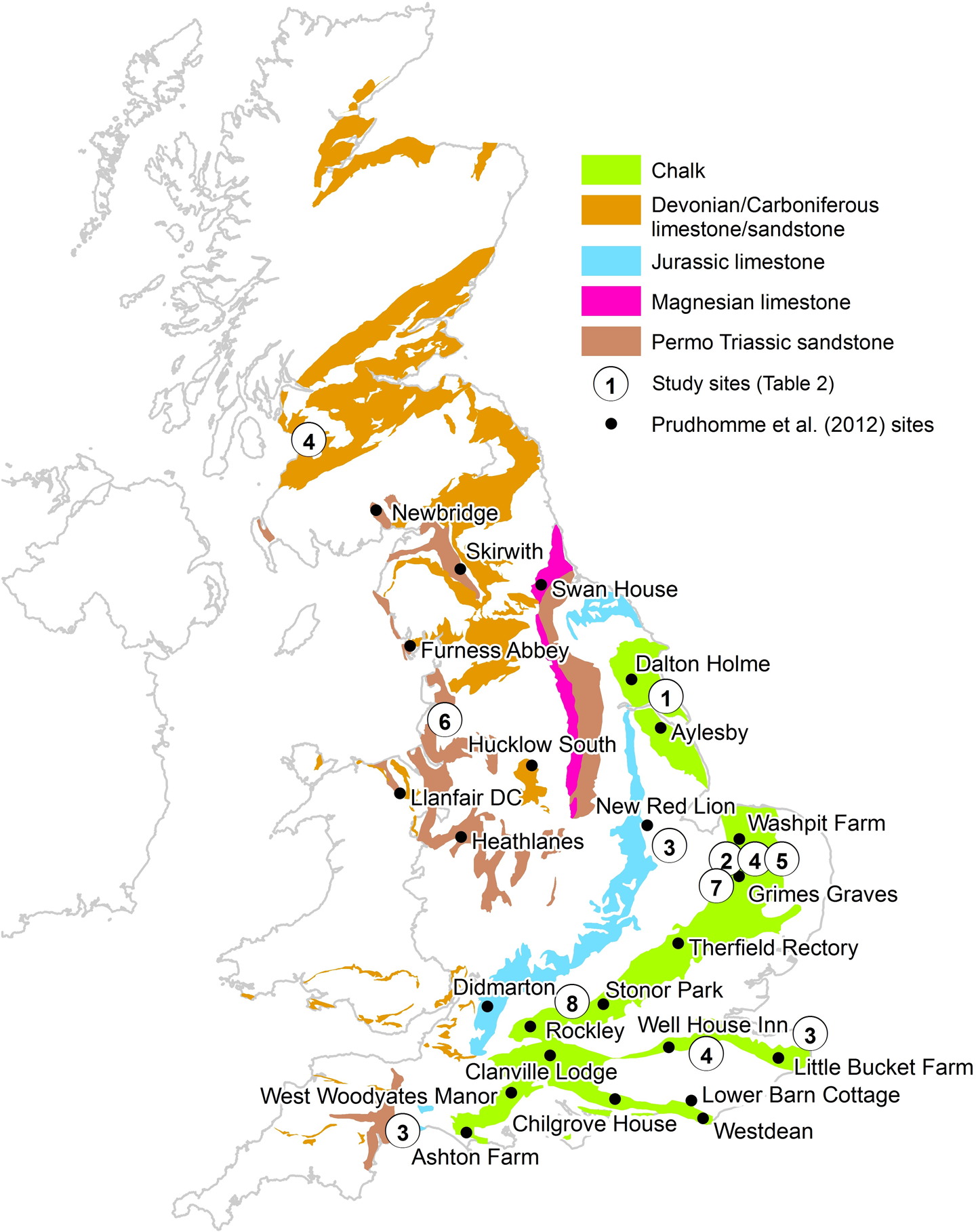
Locations of UK groundwater and climate-change impact studies.
Figure 1 shows the location of seven observation boreholes in the Chalk aquifer, at Chilgrove House, Dalton Holme, Rockley, Stonor Park, Therfield Rectory, Well House Inn and West Dean No.3. These sites are Index Boreholes that are part of the UK’s long-term observation borehole network and as such are taken to be unaffected by groundwater abstraction (NGLA; http://www.bgs.ac.uk/research/groundwater/datainfo/levels/ngla.html). Each site has a groundwater level record of more than 40 years. Local hydrogeological factors at some of the sites may constrain groundwater levels; see British Geological Survey (2014) for additional site information. Figure 2 gives the normalized (SGI) hydrographs for the boreholes after Bloomfield and Marchant (2013) and shows that groundwater levels at all seven sites reflect the same broad multi-annual episodes of high and low groundwater level stands. Note that notwithstanding the differences in the autocorrelation of groundwater levels between sites, the five shorter hydrographs appear to mirror multi-annual variations in groundwater levels at the sites of the two long records, i.e. from Chilgrove House and Dalton Holme.
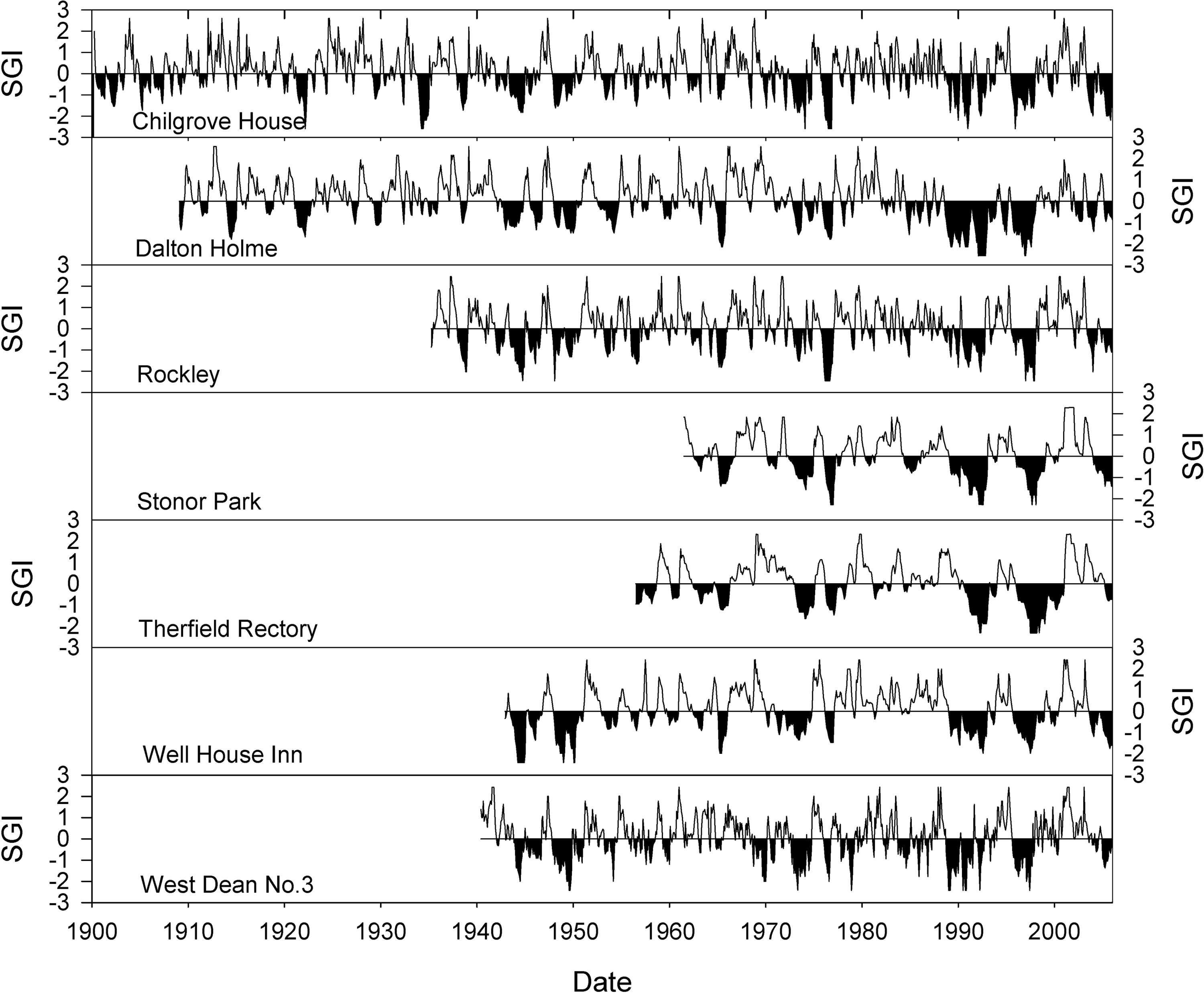
Normalized groundwater level, based on the Standardised Groundwater level Index (SGI) of Bloomfield and Marchant (2013) for seven index boreholes in the Chalk aquifer of England.
Using the Mann-Kendall test as implemented in R package ‘Kendall’ (Hipel and McLeod, 1994), Kendall’s tau and its significance level have been estimated for each of the sites to test for the presence of significant trends. The trend test has been applied to the normalized SGI data so that seasonality in the groundwater level data is removed prior to testing for trend. The results are given in Table 1. A number of factors may influence the results of Mann-Kendall tests (Clarke, 2010) including the effect of start and end dates of time-series as well as local catchment and hydrogeological factors (information about the hydrogeological context for each of the seven sites can be found on the British Geological Survey website (British Geological Survey, 2014). Consequently, it is not possible to make direct comparison of trends between the sites due to the different record lengths and start and end dates. However, the results show that at all but one of the sites (Well House Inn) there has been a decline in groundwater levels over the respective observation periods and that this decline is significant at the p=0.05 level for four of the sites (Chilgrove House, Dalton Holme, Stonor Park and Therfield Rectory), which importantly include the two longest records.
Results of Mann-Kendall trend test for seven long SGI time-series from the Chalk aquifer. Significant trends are shown in bold.
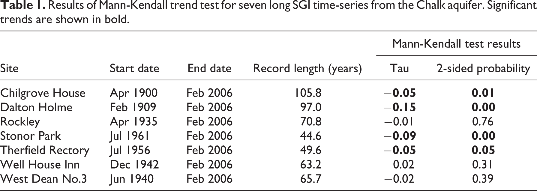
It is difficult to unambiguously identify trends in hydrological time-series and ascribe them to climate change (Wilby, 2006), and in the present study the results of the Mann-Kendall tests do not provide direct evidence for the impact of climate change on groundwater levels. However, the results (Table 1) do indicate that long-term decline in groundwater levels may be present widely in the Chalk aquifer of the UK. Climate change may be one contributory factor to declining levels along with changing patterns in groundwater abstraction and groundwater resource management. Further work to characterize trends in groundwater levels in conjunction with trends and changes in the seasonal characteristics of precipitation and temperature, as well as changes in abstraction and management practices, is required.
III Projections of future changes in recharge and groundwater levels
In contrast to the limited number of studies that have analysed trends and variability in historic groundwater levels, an increasing number of researchers are investigating potential future changes in groundwater levels in response to climate change. In line with the warming of the global climate over the past 150 years (IPCC, 2007), the climate of the UK has changed and average temperatures have risen. Evidence for this is provided by the instrumental record of temperature for central England (Parker and Horton, 2005; Parker et al., 1992): 16 of the 30 warmest years between 1659 and 2012 have occurred after 1980. To assess the effects of continuing changes in the UK’s climate a number of researchers have used deterministic climate model projections to quantify changes in groundwater resources. These studies are reviewed in this section prior to a summary of some new projections that we have made using the UK Met Office’s UKCP09 probabilistic climate projections (Murphy et al., 2009). Reviews of groundwater impact studies outside the UK are provided by Dragoni and Sukhija (2008), Green et al. (2011), Taylor et al. (2013), and Treidel et al. (2012).
1 Estimating impacts and uncertainties
The simulation of the effects of climate change on hydrological variables, such as groundwater recharge and groundwater levels, necessitates the use of a model of some type – perhaps based on relatively simplified mathematical concepts (Wilby et al., 2006), statistical analyses of data (Chen et al., 2002) or complex representations of physical processes (Ferguson and Maxwell, 2010). These hydrological models are typically at a higher spatio-temporal resolution than climate models. Consequently, climate projections are generally downscaled for application in catchment hydrological or groundwater models. This can be done using a number of methods (Maraun et al., 2010) but, whichever is applied, the results of a climate-change impact study should be described within the context of the range of uncertainties within the modelling process. A number of sources of uncertainty should be considered, relating to the representation and modelling of the catchment or groundwater system, to the projection of the future climate and to future socio-economic change at the local or catchment scale (Holman, et al., 2012). Similarly to uncertainty in hydrological modelling (see Beven, 2009), a number of sources of uncertainty are associated with the projections of climate change: (1) the formulation and accuracy of climate models; (2) the magnitude of anthropogenic emissions; (3) the temporal and spatial effect of natural variations internal to the climate system; and (4) the method of downscaling climate model information to the regional or catchment scale (Rowell, 2006). To date, no studies have assessed the full cascade of uncertainty from climate model projection through climate downscaling and groundwater modelling to simulated impact. The following review summarizes the studies of UK groundwater systems that have been published in the peer-reviewed literature since 2002. A small number of older studies exist (e.g. Cole et al., 1994; Cooper et al., 1995; Limbrick et al., 2000; Malcolm and Soulsby, 2000) but these are not considered here. First we review impacts on groundwater recharge and then we consider projections of changes in groundwater levels.
2 Groundwater-recharge impacts
To undertake an assessment of potential changes in groundwater levels and aquifer storage, it is necessary to quantify changes in groundwater recharge. Aquifers can be replenished by both diffuse recharge across the land surface and focused recharge via leakage from, for example, rivers, lakes, agricultural irrigation schemes, sewerage systems and pressurized water mains. Most studies that have investigated potential future changes in groundwater resources in temperate climates such as the UK have considered only changes in diffuse groundwater recharge (Green et al., 2011). This has been because diffuse recharge is generally the major input to the groundwater balance, but also partly because the consideration of changes in other sources of recharge, such as agricultural irrigation, necessitates an analysis of socio-economic change and a multi-disciplinary approach; most of the existing studies of the impact of climate change on groundwater-recharge impact have been undertaken by researchers working within the hydrological sciences discipline. When considering diffuse groundwater recharge there is a need to differentiate between recharge, which is generally considered to be the downward vertical flux at the water table, and potential recharge, or drainage from the base of the soil zone. Rates of potential recharge at a location and point in time differ from recharge rates at the water table due to the buffering effect of the unsaturated zone (Ireson and Butler, 2011; Ireson et al., 2006).
The construction of projections of future recharge rates across an area has necessitated the use of numerical models. The validation of these models against observations is difficult and consequently they have generally been calibrated through the application of groundwater flow models that can be tested against observed groundwater levels and river flows (e.g. Heathcote et al., 2004; Jackson et al., 2011). However, simulated recharge rates are in most cases uncertain because the parameterization of models is based on a land surface that exhibits highly heterogeneous coverage of soil, geology, vegetation types and land-use practice (Holman, 2006). Understanding of the controls on groundwater recharge within the UK has improved during the last decade (Ireson and Butler, 2011; Ireson et al., 2006; Roberts and Rosier, 2006), through research programmes such as the Natural Environment Research Council (NERC) funded LOCAR programme (Wheater et al., 2006), but knowledge remains limited (Green et al., 2011).
Less than a decade ago very little research had been undertaken into potential changes in groundwater resources generally, and even less into groundwater recharge specifically (Green et al., 2011). Those climate-change and water-resource impact studies that had been performed predominantly examined surface water systems. Since then the number of studies investigating future groundwater resources has increased each year (Green et al., 2011). These have focused on both the global scale (Döll, 2009; Döll and Fiedler, 2008) and the catchment scale (e.g. Herrera-Pantoja and Hiscock, 2008; Holman, 2006; Jackson et al., 2011).
Using a global hydrological model on a 0.5° resolution with a daily time-step, Döll (2009) estimated the vulnerability of global-scale water resources to climate change. This involved the simulation of changes in groundwater-recharge rates using two global climate models (GCMs) and both a medium (B2) and a high (A2) greenhouse gas emissions scenario (IPCC, 2000). The results are at a reasonably coarse scale, but suggest that changes in mean groundwater recharge by the 2050s (2041–2070) compared to a 1961–1990 baseline would be in the range of ±30%.
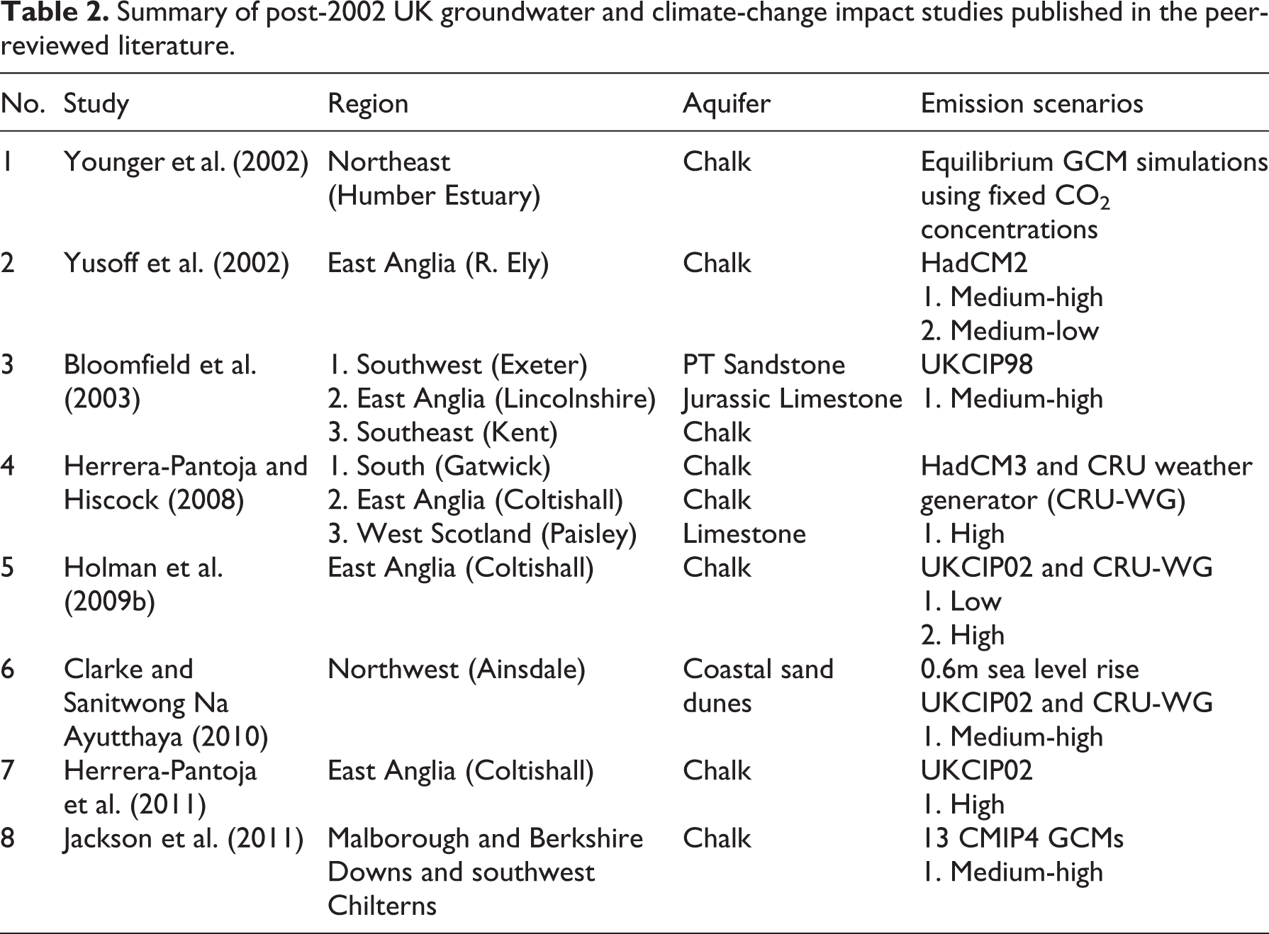
Eight separate studies (Figure 1 and Table 2) have been reported, since 2002, which project recharge rates in the UK over the 21st century. These cover 12 sites and predominantly focus on the Chalk aquifer in southeast England. Almost all the studies reviewed applied models that simulate recharge using conceptual soil moisture accounting (SMA) methods based on the Penman-Grindley model (Grindley, 1967; Penman, 1948). Importantly, these models do not incorporate complexities such as the attenuating effect of the unsaturated zone, and therefore consider only potential groundwater recharge. Projections are typically made for at least one of three time-slices in the 21st century. These can be generalized as the ‘early’ (2020s and 2030s), ‘middle’ (2040s and 2050s) and ‘late’ (2080s) 21st century. The recharge models are driven using climate data derived from GCMs for a given time-slice and under a certain emission scenario. These are then downscaled to represent the local climate at the site of interest. Typically this is achieved by using the GCM data to generate change factors which are used to perturb an observed historical climate record. Generally, for UK projections, the GCM of choice is one of the UK Met Office Hadley Centre’s coupled models (e.g. HADCM2 and HADCM3; Gordon et al., 2000).
Summary of post-2002 UK groundwater and climate-change impact studies published in the peer-reviewed literature.
In an early study, Yusoff et al. (2002) estimated impacts using a SMA model coupled with a two-layer transient groundwater model. Using climate projections based on medium-low and medium-high emissions scenarios, they simulated longer and drier summers for a site in Norfolk with maximum decreases in seasonal potential recharge of up to 35% and 26%, respectively, by 2050. These reductions in summer are offset by increased recharge during winter making annual changes less clear (10.4% decrease for medium-low scenario and 1.4% increase for medium-high).
Younger et al. (2002) adopted the approach of applying GCM output to physically based groundwater flow models to assess the effects of climate change on the Chalk aquifer of Yorkshire. They used outputs from ‘equilibrium’ GCM models that simulate the dynamics of the atmosphere with a fixed CO2 concentration. A comparison is made between the 10-year average behaviour at the end of the 50-year simulation period (2036–2045) and observed values for the period 1986–1995. Increases in total annual recharge were simulated under each of three future climates, ranging from 5 to 21%.
Using a ‘high’ emissions scenario climate-change projection generated by the HadCM3 model in conjunction with the stochastic CRU weather generator (Watts et al., 2004), Herrera-Pantoja and Hiscock (2008) investigated the consequences of a changing climate on recharge at three sites in Sussex and Norfolk in England, and Renfrewshire in Scotland. For the Sussex Chalk site the analysis of monthly climate projections indicated that precipitation would increase during the wet season (October–March) and decrease during the dry season (April–September). The magnitude of these changes increased between 2011 and 2100 resulting in a net reduction of potential recharge by 15, 23 and 39% in the early, mid- and late 21st century, respectively. For the Norfolk Chalk site the results suggested that recharge could increase by 14% in the 2020s due to twice the number of wet periods, but then progressively fall by 20% of present rates by 2080. A later study by Herrera-Pantoja et al. (2011), which investigated the impact of climate change on groundwater-fed wetlands in Norfolk, supported these findings. In this study recharge was simulated to increase by 15% in the 2020s and to decrease by the 2050s with a 29% reduction in the number of wet events.
Holman et al. (2009b) highlighted two major complexities surrounding recharge projections under climate change in Norfolk, which can also be considered important across the UK. They drove a SMA model using climate-change factors derived from 100 different climate data sets output by the CRU weather generator in an attempt to represent the uncertainty distribution of future climate. By doing so, they showed that the choice of downscaling method produced more uncertainty in the projections than the climate scenario. They found that the median of the 100 simulations projected a decline of recharge to the Chalk aquifer by up to 18% at Coltishall in Norfolk by 2020 and a decline by as much as 37% by 2050.
Jackson et al. (2011) also investigated Chalk groundwater resources in southern England, and quantified the uncertainty in the projections due to the choice of GCM. Thirteen different GCMs were used to simulate potential recharge over the Marlborough and Berkshire Downs and southwest Chilterns for the 2080s time-slice (2071–2100). The ensemble average suggested there will be a ˜5% reduction in annual potential recharge across the aquifer, although this was not statistically significant at the 95% confidence level. The results for simulated changes in annual potential groundwater recharge ranged from a 26% decrease to a 31% increase by the 2080s, with 10 predicting a decrease and three an increase. On average the multi-model results suggested that seasonality will be enhanced with more potential recharge occurring during the winter but for a shorter period of time. Significant changes were simulated to occur during April and October. The ensemble average suggested that potential recharge across the Kennet catchment will decrease from 0.4 to 0.28 mm day-1 during April and from 0.62 to 0.29 mm day-1 during October.
Herrera-Pantoja and Hiscock (2008) present the only available study on future changes in recharge within a Carboniferous limestone catchment near Paisley, Scotland. They projected that annual recharge will fall by 7% by the end of the century, with the largest reductions, as percentages, simulated for summer months (85%), compared to a 2% decrease in winter.
3 Groundwater-level impacts
Knowledge of potential future changes in groundwater levels is important, not only because they are indicative of the total amount of water stored in an aquifer, but also because they affect the degree to which an aquifer can be exploited (Beeson, 2000; Misstear and Beeson, 2000). Water companies have a duty, under the UK Government’s Water Act 2003 legislation, to report sustainable borehole yield estimates for their sources, and to assess how they could potentially change under future climates, as part of the five-year water resources management planning cycle (Environment Agency, 2011b). Because of the control that groundwater levels have on the exploitation of the resource, much of the research assessing the impacts of climate change on UK groundwater levels has been funded by the water supply industry. Consequently, the research has generally been applied in nature with the objective of providing practical tools and methodologies that water companies can use to undertake climate impact assessments (UKWIR, 2003, 2007). Water companies have undertaken a number of studies of the potential impacts of climate change on their groundwater sources but these are all unpublished. In addition to potential changes in borehole yields, changes in groundwater levels would affect baseflow discharge to rivers, and groundwater flood risk (Hughes et al., 2011) and saline intrusion to coastal aquifers, which only a few studies have considered (Cole et al., 1994; Malcolm and Soulsby, 2000).
Yusoff et al. (2002) provided evidence of the uncertainty in groundwater-level projections under climate change at a Chalk site in Norfolk. Their study concluded it was not possible to tell whether groundwater levels will rise or fall by the 2020s or 2050s as it depended on the climate scenario chosen. Under a medium-low scenario they calculated that groundwater levels could fall by as much as 4.5 m by 2050 in the winter months, but conversely could rise by as much as 1.6 m in the spring months under a medium-high emissions scenario. Herrera-Pantoja et al. (2011) supported this conclusion after finding that a 25% change in annual recharge would change the groundwater level by as much as 2.7 m in the Chalk near Coltishall, Norfolk.
Bloomfield et al. (2003) conducted an alternative statistical approach to simulating groundwater levels by finding a multiple linear relationship between monthly rainfall values and annual minimum groundwater levels for a Chalk groundwater catchment in Kent. The model was only able to explain about 50% of the variance in the data. Furthermore, their findings contrast with the other studies in this region and project that annual minimum groundwater levels will increase in the 2020s, followed by a reduction in the 2050s and 2080s to below the present-day mean annual minimum level. For a sandstone catchment in Devon they suggested that this region will see an increase in annual minimum groundwater levels of 4% by 2080.
Potentially more vulnerable are shallow coastal aquifers such as the dune slacks in Ainsdale, Merseyside, studied by Clarke and Sanitwong Na Ayutthaya (2010). They constructed a simple water-balance model of these sand dunes, forced this with the UKCIP02 medium-high scenario climate projection (Hulme et al., 2002) downscaled using the CRU weather generator, and simulated the period 2005–2100. Using 500 randomly sampled climate sequences, they found that groundwater levels are likely to decrease by 1.0–1.5 m on average. However, these projections were heavily dependent on the stochastic sequencing of the rainfall data generated by the CRU weather generator, with possible future reductions in groundwater levels ranging from 0.5 to 3.0 m. They also investigated possible impacts from projected sea-level rise and found that this may induce a small increase in groundwater levels, although these perturbations are insignificant in comparison to the impact of climate change on recharge.
The study of Jackson et al. (2011), which explored the effect of GCM uncertainty on simulated impacts, translated simulated future changes in groundwater recharge into changes in groundwater levels, using a distributed groundwater model of the Chalk aquifer of the Marlborough and Berkshire Downs and southwest Chilterns. They report projected changes in groundwater levels at 16 observation boreholes across the region for the 2080s time-slice (2071–2100) under a medium-high (A2) emissions scenario (IPCC, 2000). Reductions in levels are calculated for almost all of the observation boreholes under all but three of the 13 GCM projections applied. The ensemble averages for each site vary between a maximum decrease in groundwater level of 2.7 m at a unconfined interfluve borehole in the Chilterns to no change at a borehole in the confined Chalk as it dips into the London Basin.
The most recent and comprehensive study was undertaken by Prudhomme et al. (2012, 2013b), which for the first time produced a consistent assessment of the impact of climate change on both river flows and groundwater levels across England, Wales and Scotland using the latest projections from the UK Climate Impacts Programme (UKCIP), including the UKCP09 probabilistic climate projections from the UK Met Office Hadley Centre (Murphy et al., 2009). This study used two climate model projection products to quantify impacts: Projections from the ensemble of 11 variants of the UK Met Office Regional Climate Model (HadRM3-PPE) as continuous time-series of climate variables from 1950 to 2099 (Prudhomme et al., 2013a). Probabilistic projections of changes in climate variables as ensembles of 10,000 monthly change factors for the following three 30-year time-slice and greenhouse gas emission scenario combinations: 2050s and medium emissions scenario (A1B); 2080s and medium emissions scenario (A1B); and 2050s and high emissions scenario (A1F1) (Murphy et al., 2009). Hereafter we refer to these as the UKCP09 projections.
Both of these sets of climate projections were applied to the distributed ZOOMQ3D groundwater model of the Chalk aquifer used by Jackson et al. (2011), and to R-Groundwater (Jackson, 2012) lumped catchment groundwater models of groundwater-level time-series at 24 observation boreholes (Figure 1) across Great Britain in four principal aquifer types: Chalk, Limestone, Sandstone and Lower Greensand. In summary, R-Groundwater simulates groundwater level time-series at a point by linking simple conceptualized algorithms of soil drainage, the transfer of water through the unsaturated zone and groundwater flow. It takes time-series of rainfall and potential evapotranspiration as input, and produces a time-series of groundwater level. An example of the comparison between an observed groundwater level time-series and that simulated by R-Groundwater is presented in Figure 3 for the Lower Barn Cottage site on the Lower Greensand (Figure 1), at which the pattern of water-table fluctuation is relatively irregular. A more detailed description of the code and its application is presented by Upton and Jackson (2011). The R-Groundwater models applied in the study of Prudhomme et al. (2012) were calibrated against typically 20 years of monthly groundwater-level data using a Monte Carlo parameter estimation procedure involving one million simulations. Model performance was assessed using a range of criteria, including the Nash-Sutcliffe Efficiency and bias at percentile points of the distribution, according to the modelling protocol of Crooks et al. (2012), which was applied systematically to all models in the study. While there are issues associated with the use of conceptual models in climate-change studies, as discussed for example by Leavesley (1994), the parsimonious structure of R-Groundwater means that parameter uncertainty is small compared to that arising through the use of a distributed physically based groundwater model. Prudhomme et al. (2012) assessed the acceptability of the use of R-Groundwater for simulating future changes by comparing it to projections made using a distributed ZOOMQ3D groundwater model of the Chalk of the Marlborough and Berkshire Downs (Jackson et al., 2011). They found that the projections made using the two models were in good agreement.
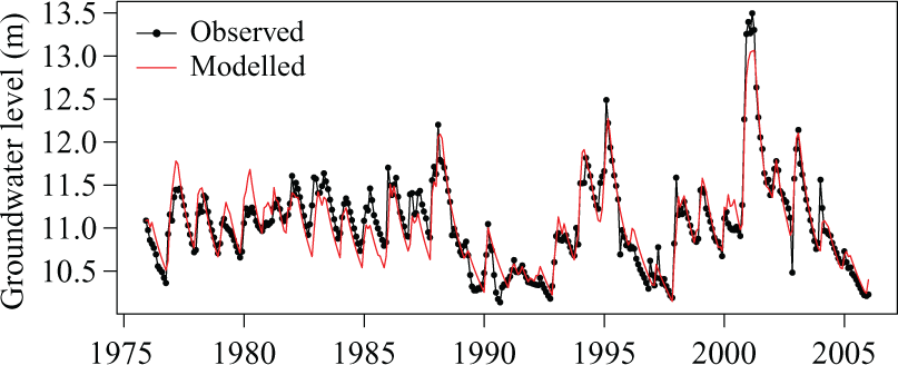
Comparison of measured groundwater levels at the Lower Barn Cottage observation borehole on the Lower Greensand with those simulated by Prudhomme et al. (2012) using R-Groundwater.
An example of the type of output produced by Prudhomme et al. (2012) is shown in Figure 4, which plots the mean monthly and annual changes in groundwater level for the Rockley Chalk observation borehole, for the 2050s, based on a medium (A1B) emissions scenario and both the HadRM3-PPE and UKCP09 projections. For this site the median change in annual level is approximately zero, and changes in winter and summer levels are centred on positive and negative values, respectively.
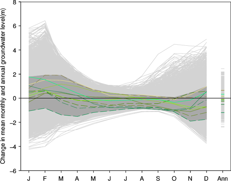
Projections of change in mean monthly and annual groundwater level (m) for the 2050s under a medium (A1B) emissions scenario for the Rockley observation after Prudhomme et al. (2012). Green lines, enclosed by a dark grey envelope, are projections based on HadRM3-PPE 11-member climate ensemble (Prudhomme et al., 2013a). Each light grey line is a projection based on one member of the UKCP09 10,000 member ensemble.
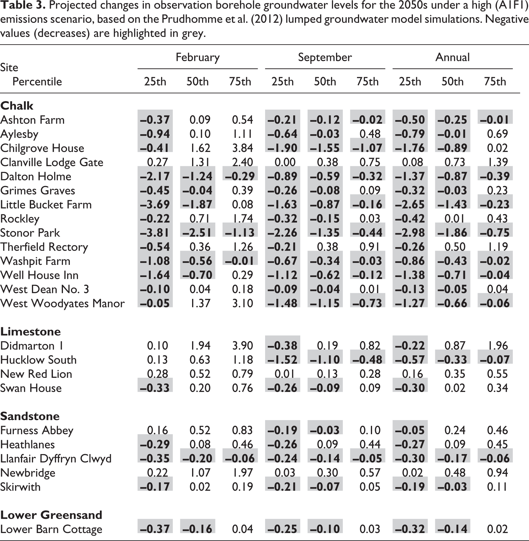
In Table 3 we present some previously unreported results derived from an additional analysis of the Prudhomme et al. (2012) projections. This shows simulated changes in February, September and annual groundwater levels for the 24 sites modelled using the lumped groundwater model, based on the UKCP09 change factors for the 2050s under the high (A1F1) emissions scenario. Changes are listed for the median of the ensemble of 10,000 simulations, and for the 25th and 75th percentiles. Considering the median values of the distributions, decreases in annual levels are projected for 13 of the 24 sites. Fourteen of the models project increases in median February levels and 18 decreases in median September levels. This provides a general picture of increasing winter and decreasing summer levels. However, these results show that there is uncertainty about the direction of change; the medians of the distributions of change for February, September and annually are positive at 16, 6 and 9 of the 24 sites, respectively. The projected changes in Table 3 also indicate that site-specific differences are apparent. For example, at Clanville Lodge Gate (Chalk), New Red Lion (Limestone) and Newbridge (Sandstone) increases in annual, February and September levels are projected at all of the three percentile points of the ensemble distributions. We consider that this highlights that local hydrogeological conditions play an important role in controlling site-specific groundwater levels and the associated shape of the distribution of observations, and consequently the response at a site to changing climate drivers. However, this conclusion needs further testing because the models are not driven by exactly the same set of projections as they are in different locations in the country.
Projected changes in observation borehole groundwater levels for the 2050s under a high (A1F1) emissions scenario, based on the Prudhomme et al. (2012) lumped groundwater model simulations. Negative values (decreases) are highlighted in grey.
As discussed previously, there are a number of sources of uncertainty associated with simulated projections of climate change. The UKCP09 projections were designed to quantify the spread of possible outcomes by incorporating information on the various sources. Modelling uncertainties associated with the use of the UK Met Office’s Hadley Centre global climate model (GCM) have been quantified through the use of an ensemble of simulations based on different parameterizations of the GCM, i.e. different variants of the model. The uncertainty associated with the selection of the GCM, i.e. climate model structural uncertainty, is also reflected in the UKCP09 projections, as climate projections from 12 other GCMs were incorporated into the analysis. Finally, all the UKCP09 projections were assigned probabilities, based on the modelling and statistical framework used in their preparation (Murphy et al., 2009). However, uncertainties associated with future greenhouse gas emissions were not directly incorporated into the UKCP09 ensemble of 10,000 projections. Rather, separate probabilistic projections have been provided for different future emissions scenarios.
To examine the uncertainty associated with the choice of greenhouse gas emissions scenario, in Figure 5 we plot changes in mean February, September and annual groundwater levels at the Rockley observation borehole, simulated under two SRES (IPCC, 2000) scenarios: A1B (medium) and A1F1 (high). This shows that the differences in the simulated changes in groundwater levels, for the 2050s time-slice, between these two emissions scenarios is small compared to the spread of the ensembles. For mean February and annual levels, the medians of the projections, and the spread of the ensembles, increase a little moving from the A1B to the A1F1 scenario. Median September levels are very similar between the scenarios, but interestingly the spread of the projections reduces under the A1F1 scenario. This is related to the occurrence of warmer summers under A1F1, resulting in longer periods without recharge during which the water table recesses to a more consistent level.

Box plots of the distributions of simulated changes in mean February, September and annual groundwater levels at the Rockley observation borehole, for the 2050s time-slice, based on the UKCP09 10,000 member ensembles, for both the medium (A1B) and high (A1F1) greenhouse gas emission scenarios.
IV Conclusions
The evidence for and understanding of climate-change impacts on groundwater levels based on the observational record, both internationally and in the UK, are poor. There is no evidence for systematic changes in groundwater drought frequency or intensity in the UK, but some evidence of multi-annual to decadal coherence of groundwater levels and large-scale climate indices has been found, which should be considered when trying to identify any trends. The identification of trends is complicated by the fact that the UK’s groundwater level monitoring network is not specifically designed to characterize long-term changes in groundwater levels. This network needs to be capable of characterizing long-term trends in groundwater level, quantifying changes in the length and timing of the groundwater-recharge season, and characterizing extreme events. Relatively high frequency (better than daily) groundwater level measurements are required at each of the network sites and each site needs to be unaffected by other change factors. There is a need to improve existing historic groundwater level data by systematically infilling gaps, removing spurious data points and establishing a reference data set of the best observations for future climate impact studies. We have demonstrated the benefit of maintaining long groundwater level records by analysing trends in the Standardised Groundwater level Index at seven sites on the Chalk aquifer. Statistically significant declines in groundwater level have been calculated at four of these. This is an indication of a change in stress on these aquifers over time. However, it is not possible to say, without further analysis, whether this is as a result of a change in the driving climate or a change in abstraction or land use, which are more likely reasons.
The evidence for the impacts of future climate change on UK groundwater recharge and levels is limited. The number of studies that have been undertaken is small and different approaches have been adopted to quantify impacts. Furthermore, these studies have generally been focused on relatively small regions and reported local findings. Consequently, it has been difficult to compare them between locations. The study by Prudhomme et al. (2012, 2013b) addressed this issue by adopting a consistent approach across multiple sites. It also quantified the uncertainty associated with the climate projections through the use of probabilistic climate ensembles (Murphy et al., 2009). The additional analysis of the Prudhomme et al. (2012) projections undertaken here has shown that that the majority of their models suggest reductions in annual and mean September levels, and increases in mean February levels, by the 2050s under a high greenhouse gas emissions scenario, when expressed by the median of the ensemble of simulations. However, it should be recognized that local hydrogeological conditions can be an important control on the response at a site. Prudhomme et al. (2012) have undertaken one of the most detailed assessments of the uncertainty associated with climate projections; however, studies are required that assess the full cascade of uncertainties inherent in the simulation of climate impacts.
Aquifers are large stores of water, and with careful management provide the potential to ameliorate the impacts of potentially more severe droughts on both surface water and groundwater supply. The role of aquifers as buffers to impacts needs to be explored through the wider use of regional groundwater models. Many more hydrological models have been used than groundwater models in impact studies, but these do not adequately represent delays in the transfer of water from the soil, through both the unsaturated zone and saturated zone, to surface waters and abstraction boreholes. Estimates of future regional resources need to be linked to the security of groundwater supply. This requires linkages to be made between observations of groundwater level at observation boreholes and the performance, or yield, of an abstraction borehole. This needs to be considered within a holistic framework that considers the conjunctive use of both surface water and groundwater resources.
Further research is required not only to assess changes in water resources but also to assess potential changes in hazards such as groundwater flooding, or soil moisture controlled landslides. This will require improved understanding of changes in climate variability, groundwater flow processes and catchment responses.
Footnotes
Acknowledgements
An earlier, longer draft of this work formed an LWEC working paper. The authors are grateful for the support of Glenn Watts at the Environment Agency during the production of the LWEC paper, which led to this article. The authors publish with the permission of the Executive Director of the British Geological Survey (NERC).
Funding
This work was funded by the UK Department for Environment, Food and Rural Affairs (Defra) and steered by the Living With Environmental Change (LWEC) partnership.