
Abstract
Fieldwork at Amarna from autumn 2023 to summer 2024 included excavations at the Great Aten Temple, the launch of a new survey and site management project focused on Amarna’s housing areas, and the continuation of several post-excavation projects. The post-excavation work reported on here is the study of faience inlays from the Great Aten Temple, and skeletal materials and hair from the non-elite cemeteries. Ongoing community outreach associated with both the cemetery and housing work is also presented.

Introduction
In 2023, the Amarna Project 1 undertook one extended season of fieldwork (31 August to 17 December), which focused first on excavation and restoration at the Great Aten Temple and then on the survey of houses in the Main Suburb (fig. 1). This preliminary report summarises excavations at the Great Aten Temple outside the Long Temple and at the East Gateway, and the results of the housing survey. It presents ongoing work to record faience inlays from the temple and human skeletal remains and hair from the non-elite cemeteries, and community outreach conducted as part of the housing survey and cemetery project. It also briefly summarises the construction of a protective boundary wall in June 2024.
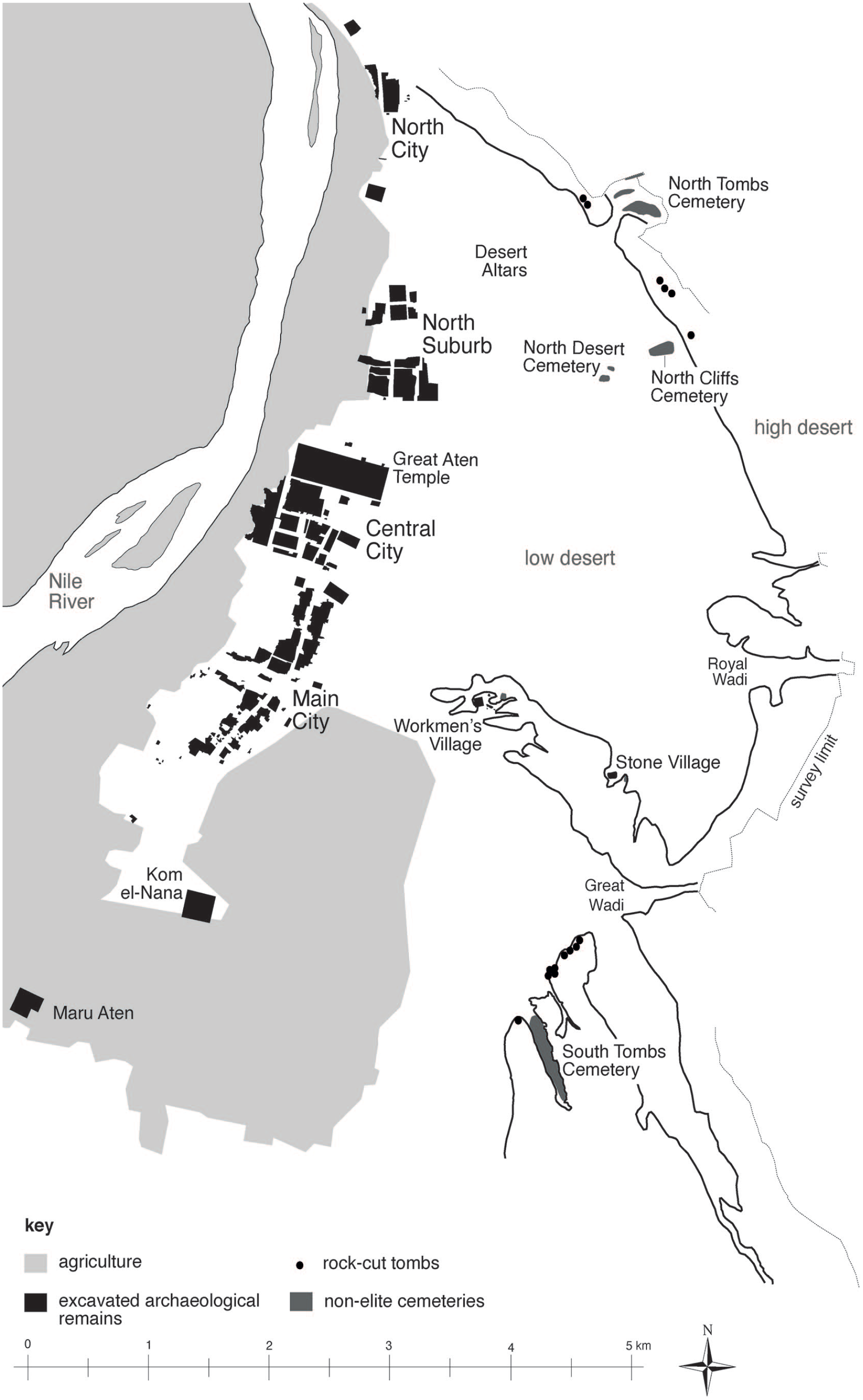
Map of Amarna, including the locations of the Great Aten Temple, Main City, and non-elite cemeteries (base map: Barry Kemp and Helen Fenwick, with additions by Anna Stevens, the Amarna Project).
The Great Aten Temple, Autumn 2023
The Amarna Project has been reinvestigating the Great Aten Temple since 2012 with the aims of re-examining the site excavated during two seasons in the 1930s by Pendlebury for the Egypt Exploration Society (EES), 2 and making the temple more intelligible to visitors and secure for the future, by marking the main building outlines in new materials. 3 The following sections present the archaeological work undertaken during autumn 2023 in two areas that were less extensively investigated by Pendlebury: along the north side of the Long Temple and at the East Gateway of the temple complex (fig. 2). A preliminary report on the study of inlays from the Great Aten Temple is also provided.
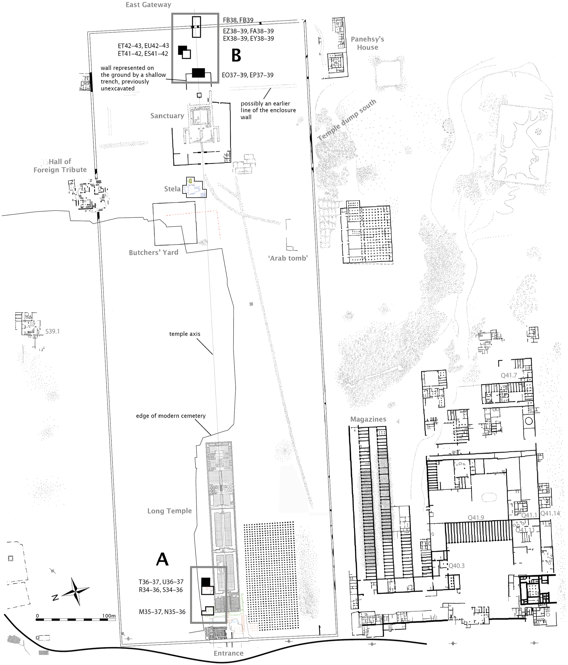
Plan of the Great Aten Temple showing in thick grey outlines the location of the excavations along the north side of the Long Temple and at the East Gateway at the rear of the temple compound in 2023. The black squares indicate the areas excavated in 2023 (plan: Barry Kemp and Fabien Balestra, the Amarna Project).
Excavations along the north side of the Long Temple (D. Driaux)
Background
From 1 to 23 October 2023, excavations resumed along the northern edge of the temple site, to the north of the stone-built Long Temple (possibly the Gem-pa-Aten), where previous seasons had been conducted in 2014, 2015, and 2018. The excavation team comprised Delphine Driaux (supervising archaeologist), Julia Vilaró Rodriguez, and eight local workmen: Mohamed Mustafa Bardisi, Ahmed Berberi, Ragab Abd el-Hamid, Ahmed Khallaf Mansour, Magdi Mohamed Ali, Ismain Ahmed Hasanein, Mohamed Ahmed Qenawi, with the assistance of Waleed Mohamed Omar.
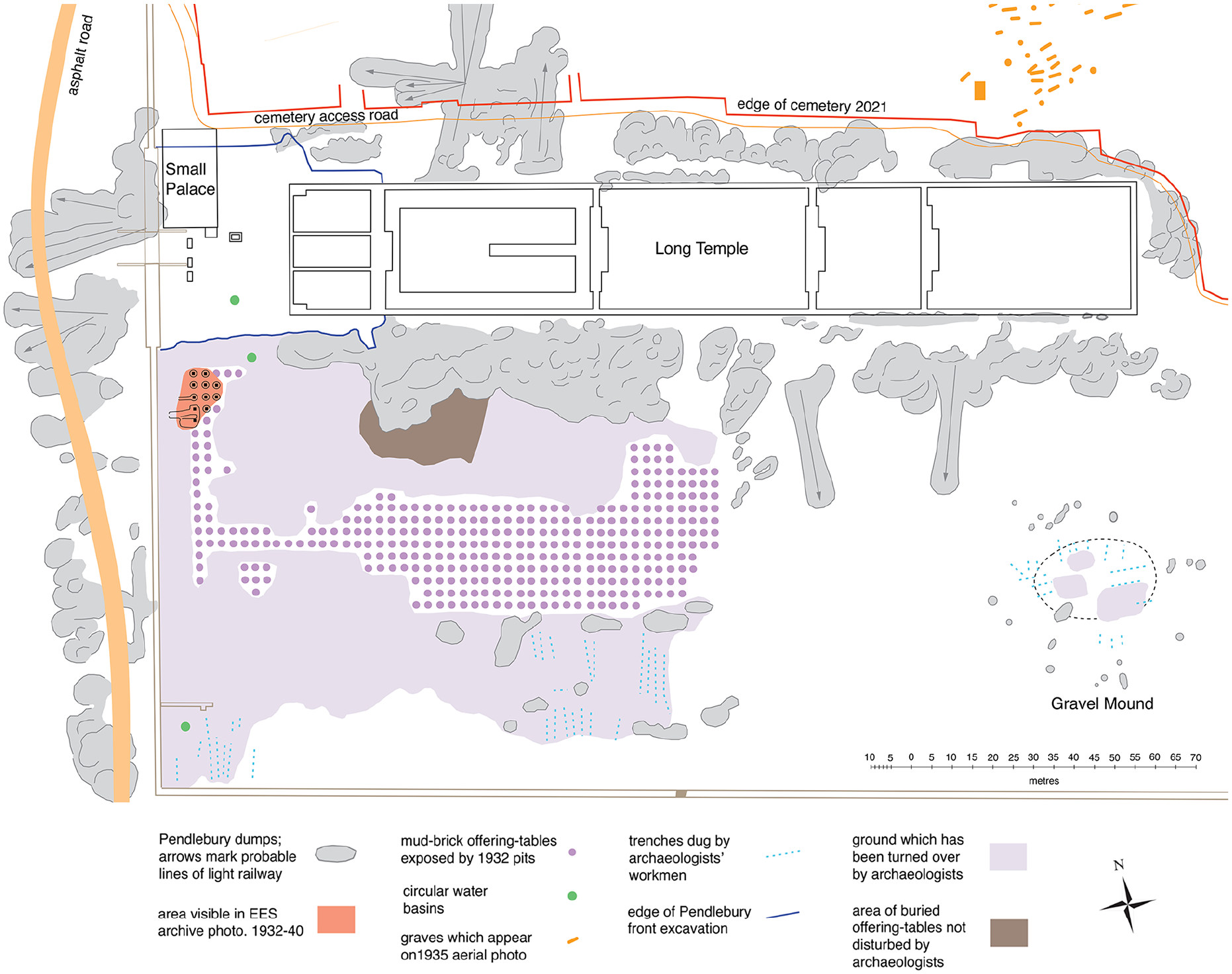
The study area is around 15 m wide, bordered to the north by the modern cemetery of El-Till and to the south by the Long Temple. In 2014, five squares (M35–37, N35–36) measuring 5 m by 5 m were opened at the north-west corner of the Long Temple (fig. 2) to expose the remains of a ramp, uncovered by the Pendlebury expedition. 4 The recent excavations revealed that the ramp was likely used during construction of the Long Temple, which belongs to the second construction phase of the temple overall. 5 Beneath the ramp, a thin layer of sand covered the plastered mud floor and the remains of several mudbrick offering-tables of the first phase of the temple’s development. Pendlebury was the first to expose some of the offering-tables in this area, and suggested that the ‘forest’ of offering-tables on the south side of the temple had its equivalent on the north side as well. 6 To verify this, in 2015 investigations were pursued in four squares (R35–36, S35–36) 15 m to the east, skirting around a large Pendlebury spoil heap in the intervening ground. It quickly became clear that the mudbrick offering-tables did not continue this far. Instead, the excavations revealed the mud floor of the temple’s first phase, preserving in places a hard, lumpy surface, as if it had been extensively wetted. The floor had been cut by several small, roughly circular holes (diameter 15–20 cm) to contain wooden posts but also by larger, deeper holes, dug to receive pottery jars. 7 This unexpected discovery led to the opening of two adjacent squares to the north (R34, S34), close to modern tomb enclosures, in 2018. The excavation revealed evidence of mud flooring, which may correspond to the temple’s second phase, when the Long Temple was in use. It did not, however, reveal the precise function of the various holes, and while the use of the post holes in a shelter or an awning could be envisaged, this needed verification by extending the excavation area to the east and west.
Preliminary excavation results
In autumn 2023, four squares were opened: T36, T37, U36, and U37, located immediately east of the 2015 and 2018 squares (fig. 2), in order to better understand the function of these holes. The area was covered by the remains of Pendlebury’s spoil heap, consisting of brownish-grey dusty sand underneath which was a layer of mixed spoil and stones, the latter partly used by the EES to backfill the trench for the Long Temple wall.
The removal of these layers exposed the ‘levelling rubble’ that is found throughout the front part of the temple and which had raised up the ground between the time of the first and second temples. About 20 cm thick, this compact layer consists of mudbrick rubble, silty sand, and occasional potsherds. This layer, like the lower ones, had been disturbed by more recent graves (fig. 3), identical to those discovered to the west during the previous seasons. 8 Fourteen were present, all but one orientated east–west. Although the graves vary in size, the fills are all sand and small pebbles (fig. 4a). None of these graves have been excavated, but stratigraphically they predate the Pendlebury spoil heap and cut through the oldest levels, those dating to the Amarna Period. It is impossible to say whether they are Islamic tombs that predate the adjacent modern cemetery, or if they could date back to the Roman Period; 9 however, for convenience, the excavators have called them ‘modern tombs’.
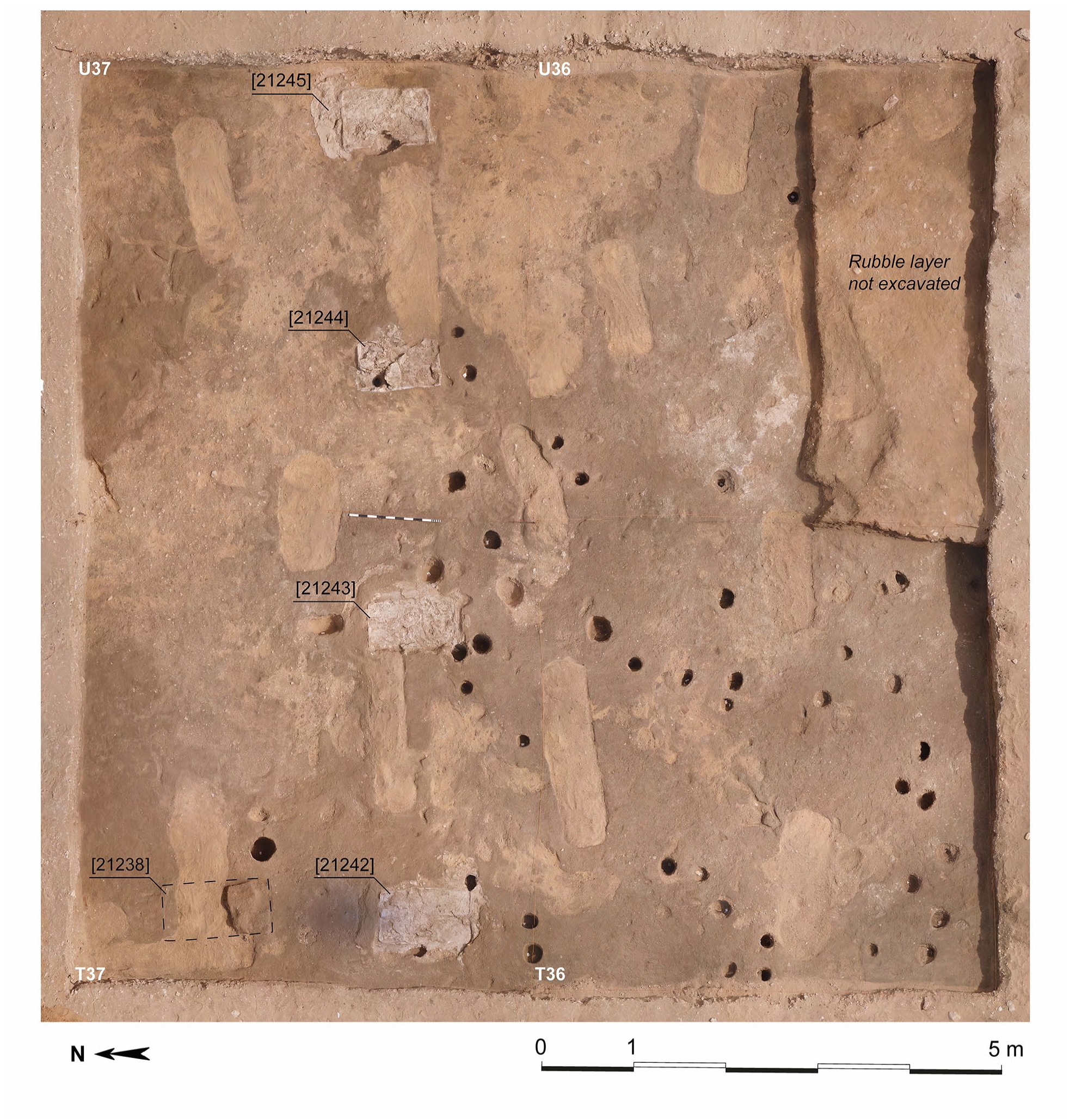
Orthophoto of the four squares excavated during autumn 2023, with the five offering-tables and the post and pot holes (orthophoto: Fabien Balestra, the Amarna Project).
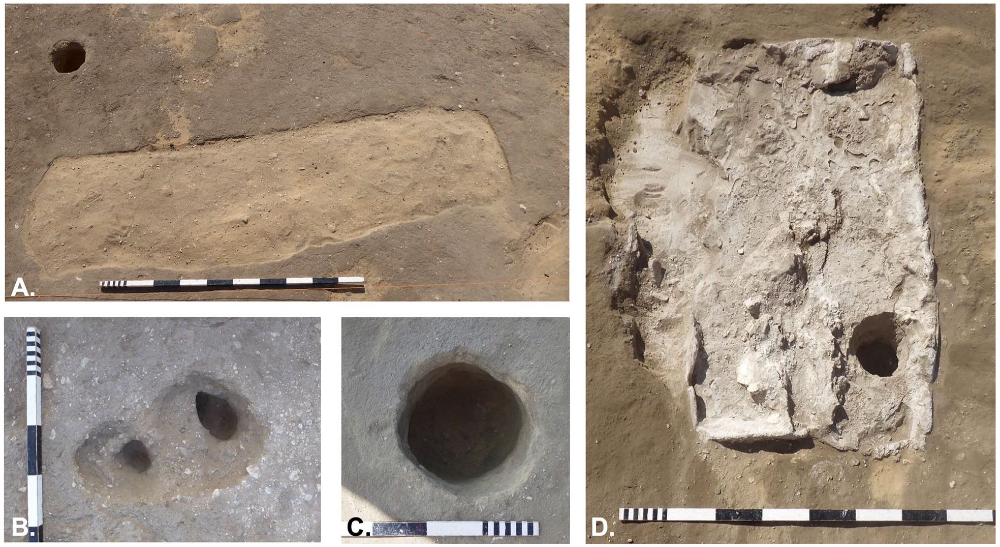
The different kinds of structures excavated north of the Long Temple in 2023. A) ‘Modern’ tomb <21162> with its fill (21161), looking south; B) post hole <21249 A–B> with shelf, looking east; C) possible pot hole <21403> with its vertical sides and flat base, looking south; D) limestone offering-table [21244] and its partially visible foundation of gypsum cement (left side of the image), looking south (photos: Delphine Driaux and Fabien Balestra, the Amarna Project).
The rubble layer covers a mud floor that was traced in all four squares, even if in some places it had completely disappeared, giving way to a mixed layer of orange-yellow sand, pebbles, patches of mud, and mudbrick fragments. This overlies the gebel and may have been packing for the mud floor. While different layers of mud floor can be seen, it is almost impossible to follow them across the four squares and determine how many layers were present, due to their thinness (sometimes <1 cm) and the slight natural slope of the ground.
In squares T37 and U37, however, excavation revealed two distinct levels of mud floor, or a reworked area of the existing floor. This observation arose via the discovery of four offering-tables, a finding which challenges the hypotheses that these structures did not extend this far. These offering-tables lie on an east–west axis, at intervals of around 2.0–2.50 m (fig. 3). Rectangular in shape, they vary in dimensions: [21242] 1.05 x 0.62 m; [21243] 0.95 x 0.52 m; [21244] 0.93 x 0.56 m; [21245] 0.97 x 0.61 m. They are built the same way, standing on a foundation of gypsum cement, which has been set into the first mud floor (fig. 4d). The limestone blocks that made up the offering-tables have disappeared, but their impressions are still visible in places; some blocks even left their surface cutting-marks in negative in the gypsum. Once finished, the offering-tables were given a thick coat of gypsum plaster, and the gypsum foundation was completely hidden by a thin layer of sand which was then covered by a new layer, or patch, of mud floor.
A fifth offering-table [21238], slightly larger (1.14 x 0.68 m), was also found 1.20 m north of offering-table [21242]. This one was made of mudbrick, some of which remained, although poorly preserved since a ‘modern tomb’ had cut through the structure. The cut offers the opportunity to see how the offering-table was built. The mudbrick appears to have been laid on a small pile of sand.
The discovery of these offering-tables tends to confirm Pendlebury’s hypothesis: there was a ‘field’ of offering-tables north of the temple. However, the discovery raises other questions, particularly about the presence of post and pot holes. The excavations continued to reveal a large number of holes (66 in total). They are all approximately circular, with dimensions ranging from 12 cm to just under 30 cm. Their depth rarely exceeds 30 cm. They often have vertical sides with a flat base, or inward-sloping sides with rounded base. It is difficult to distinguish post holes from holes that contained jars. In some cases, nevertheless, the presence of a ‘shelf’ partway down the side (fig. 4b) indicates that they received a post – which must have been relatively thin. In other cases, such as <21403> (fig. 4c), the diameter (28 cm), depth (33 cm), and profile identify it as having contained a jar. Thus far, these holes (and those from the previous seasons) do not seem to mark clear alignments that would indicate the presence of a structure. They are mainly concentrated in the south of the study area and to the south of the offering-tables. Importantly, post holes cut through three of the offering-tables (fig. 4d), suggesting that the post holes functioned after the tables had been destroyed.
There is no doubt that both offering-tables and holes belong to the first phase of the temple but the excavations suggest that this phase was punctuated by several distinct episodes. First, there were the mudbrick offering-tables, associated with the mud floor, and then the limestone offering-tables, which were set into this same mud floor, which was then resurfaced or patched. Following the destruction of the offering-tables, the post holes and their related activities might represent a last or a transitional episode before the ground surface was raised and the Long Temple built. They could also be linked to a preparatory phase for construction of the Long Temple. Further excavation may clarify these aspects.
Material found during the excavation
The layers from the first phase of the temple and the levelling rubble contained very little material, apart from potsherds. It is mainly in the most recent layers, resulting from Pendlebury’s excavations, that stone inlays, a few faience fragments, and several pieces of carved stone were recovered. These are mostly fragments of relief that may have decorated the temple, in limestone, sandstone, and Egyptian alabaster. They include (fig. 5) a scene of offering-tables (S-17541); the bottom of a cartouche binding (S-17791); and Akhenaten in profile (S-17792). Finely carved, the latter shows the lower part of Akhenaten’s face, his neck – behind which a piece of ribbon descends from a broken-away crown – and his upper torso with protruding clavicles. His left arm, incised with a pair of Aten cartouches, is stretched out, almost horizontally, in an attitude of adoration. 10
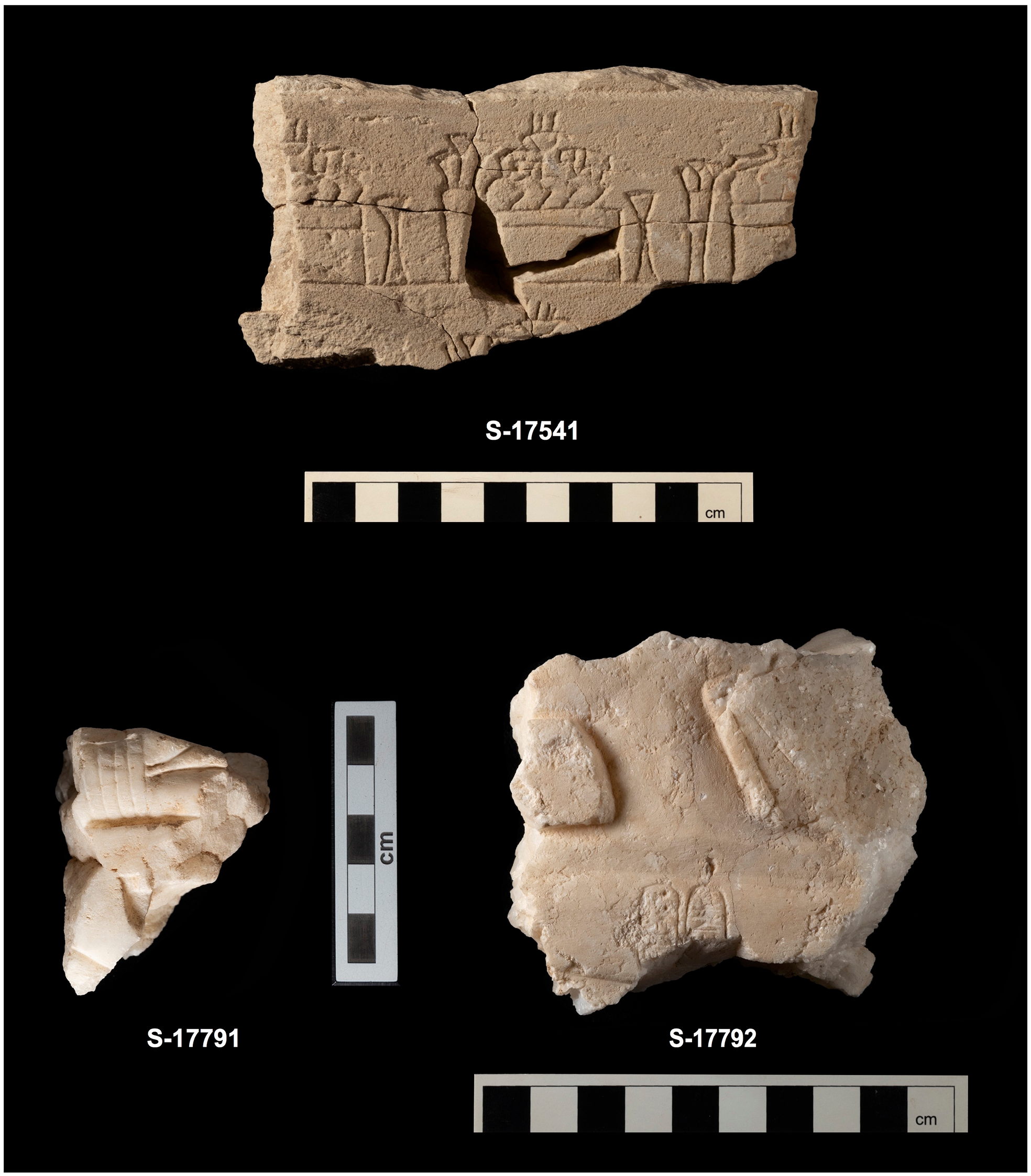
Relief fragments in limestone (top) and Egyptian alabaster (below) from Pendlebury’s spoil heap (photos: Andreas Mesli, the Amarna Project).
Third season at the rear of the Great Aten Temple (F. Balestra)
Background
From 10 September to 23 October 2023, excavations continued at the rear of the Great Aten Temple, led by the author with Waleed Mohamed Omar, Ahmed Mokhtar Mahmoud, Yahya Saddiq Abdel Fattah, Ahmed Mohamed Abd el-Rashid, and Mohamed Rabia Fatih. The team also comprised Miriam Bertram (jar sealing registration), Valentina Gasperini (ceramicist, assisted by Pamela Rose), and Andreas Mesli (photographer). This season covered 250 m2 across ten squares of 5 x 5 m divided into two sectors (Sectors 2 and 3; fig. 2). Four squares lay in the north-east corner of Sector 2, opened in 2022 (ET42–43, EU42–43). Sector 3, a new study area at the back of the Sanctuary, encompassed six squares where a shallow north–south trench (believed to be Pendlebury’s excavation trench) was visible (EO37–39, EP37–39). The overall objective is to better understand how the huge open space inside the temple compound was used, and better integrate the various structure elements and activity areas found here.
In 2021 and 2022, 11 excavations confirmed the existence of a gate in the east wall of the temple enclosure. It had been flanked by outward-projecting buttresses and was accessible by an external ramp. The 2021 and 2022 excavations offered insights into human activities near the gate and further inside, mainly with the exposure of hollow structures (pits, pot holes, and post holes). A large collection of artefacts was also uncovered. Two broad temporal phases were also identified: Amarna Period and post-Amarna Period activities, as summarised below for the 2023 work.
Amarna Period
Sector 2: The initial focus here was on determining the full extent of the hollow structures uncovered in 2022 in the north-east corner of the sector. These formed a distinct oval-shaped pattern covering approximately 8 m2 when viewed from above (pits <20556>, <20559>, <20562>, <20566>, <20570>, <20572>, and <21009>; fig. 6). The second goal was to verify whether the ground had been evened out with levelling fill during the Amarna Period as envisaged in 2022. 12 Three new squares were opened (ET43, EU42–43), while 2022 square ET42 was re-investigated.
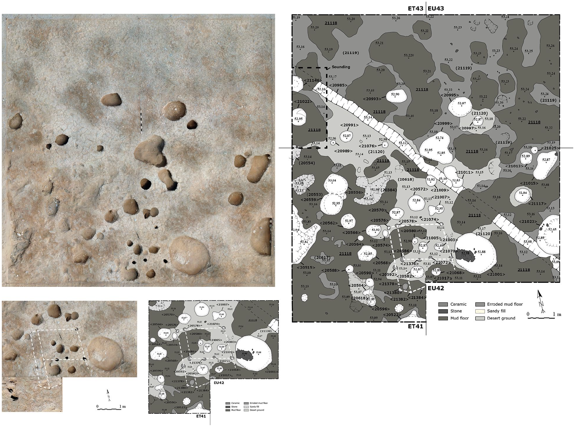
Top left: orthomosaic of Sector 2 at the end of the work. North is to the top. Right: final plan of Sector 2. Bottom left: detail of a group of pits that mark a probable wooden structure, in dotted outline (images: Fabien Balestra, the Amarna Project).
The removal of predominantly later windblown deposits exposed 26 hollow structures. Most were filled with sand with a little silt, gravel, and pebbles. Across the 26 hollow structures, three main categories can be classified based on dimensions and spatial relationships (fig. 6).
The first group comprises sixteen circular pits, which were distributed across all squares (Table 1). Measuring c. 40 cm in diameter and c. 20–36 cm deep, these pits varied in profile, with vertical to sharply angled sides and irregular to flattish bases. Some contained an assortment of potsherds and jar sealings, rarely faunal bones and botanical remains; others contained only jar sealings, as if these had been deliberately separated out. Three hundred and twenty-six fragments of jar sealings were discovered, with 33% bearing stamps and almost 11% featuring a distinct powdery blue coating (see also Bertram, below). The blue surface is reminiscent of pigment sometimes found as lumps or as deposits attached to potsherds. 13 However here, it seems to differ from the blue-painted seals, which are similar to blue-painted ceramic, found at Malqata and used for the sed-festival. 14 On the Amarna examples, this blue surface is easily brushed away.
Summary of the pits and pot holes discovered in Sector 2. In grey: the earliest pits.
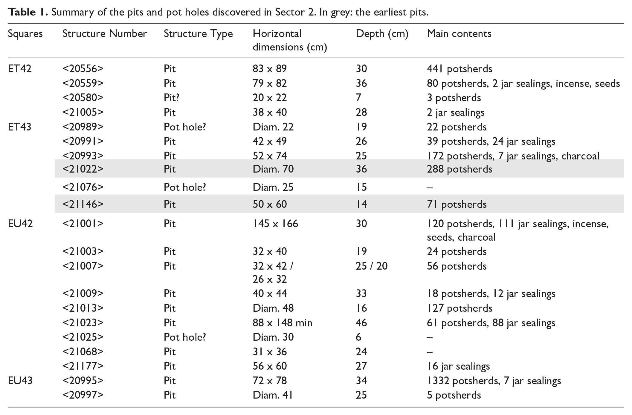
The second group comprises much larger and more complex pits. It includes two large circular pits in EU42 (Table 1). Pit <21023>, half exposed, provided well-preserved jar sealings, including the notable blue-coated ones. The reasonably good condition and ‘organisation’ of the sealings suggest that they were not simply discarded into the pit, but perhaps placed with a degree of care, probably due to the presence of specific stamped designs (fig. 7). Pit <21001> contained the majority of the jar sealings recovered this season, along with charcoal (some with resinous residues), incense, and potsherds. The latter included the upper part of an amphora, typical of the Eastern Nile Delta, of a fabric (Marl F) quite common in Qantir. 15 The vessel bears a broken, faded hieratic inscription (fig. 8). The first part is difficult to read, but the second appears to refer to an unknown toponym, sn-nsw.t or sn.t-nsw.t, ‘King’s-brother’ or ‘King’s-sister’; its significance remains obscure as no parallel seems to exist. 16 Within this group, a possible sub-category emerged with three polylobed pits, the lobes possibly cut at different times, adding further complexity to the site. These pits, located in EU42 and overlapping into EU43, shared similar fills and materials (Table 2).
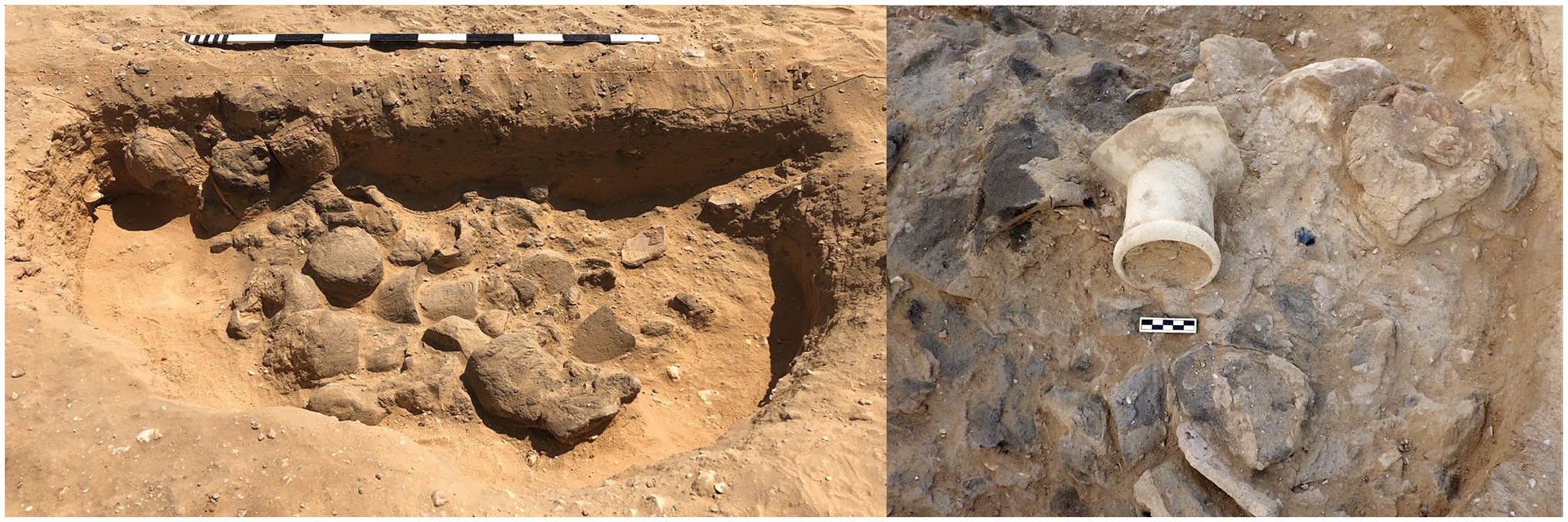
Left: jar sealings in pit <21203> during excavation. Facing east. Right: upper part of an inscribed amphora (object no. 44297) with fragmented jar sealings in pit <21001>. Facing south (photos: Fabien Balestra, Amarna Project).
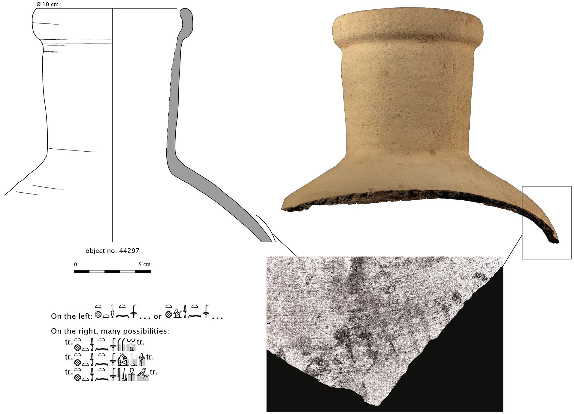
Amphora with hieratic label in pit <21001> (drawing: V. Gasperini; inking: F. Balestra; photos: A. Mesli). Transcription and translation by Marc Gabolde, UPV Montpellier 3.
Summary of the polylobed pits and stake holes/small post holes in Sector 2.
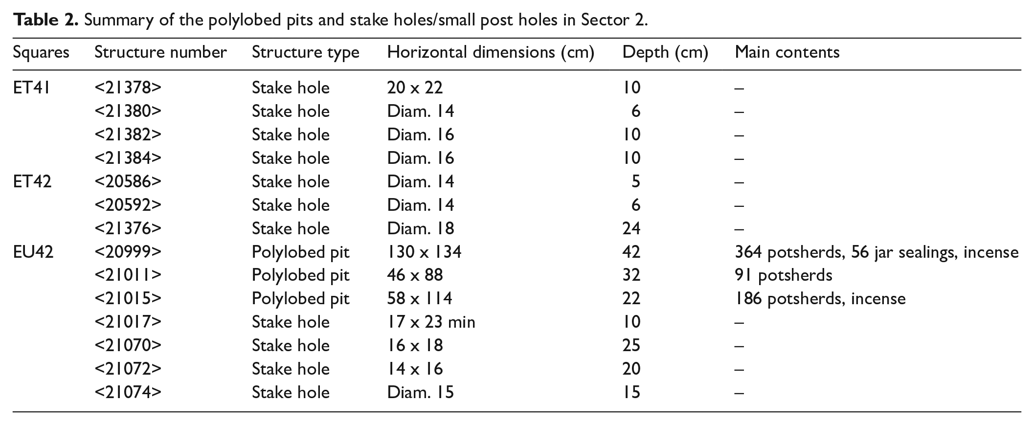
Finally, a series of eleven small circular cavities was interpreted as stake holes. Concentrated mainly in the south-west of EU42, continuing into ET42 and ET41, these empty cavities are c. 20 cm in diameter, and 6–25 cm deep. Whether they came after or before the pits remains to be determined, although the latter is more likely. They seem to form the plan of a light wooden construction of c. 7 m2, orientated north–south with three divisions: an elongated rectangular space (vestibule?) and two inner squarish areas (rooms?) (fig. 6).
All the hollow structures, regardless of type, formed voids in a mud floor or trampled surface
Sector 3: To investigate the connection between the Sanctuary and East Gateway, excavation was conducted on part of a shallow trench between these structures. The trench seems to have been created during Pendlebury’s excavation, and to have exposed the rear wall of the Sanctuary. 17 The aim here was to re-locate this wall and extend the investigation around this structure.
The removal of a small spoil heap and abandonment deposits allowed identification of two sub-phases dating to the Amarna Period (fig. 9). The first appeared to be represented only by an early pit <21228>, later covered by a fine mud floor
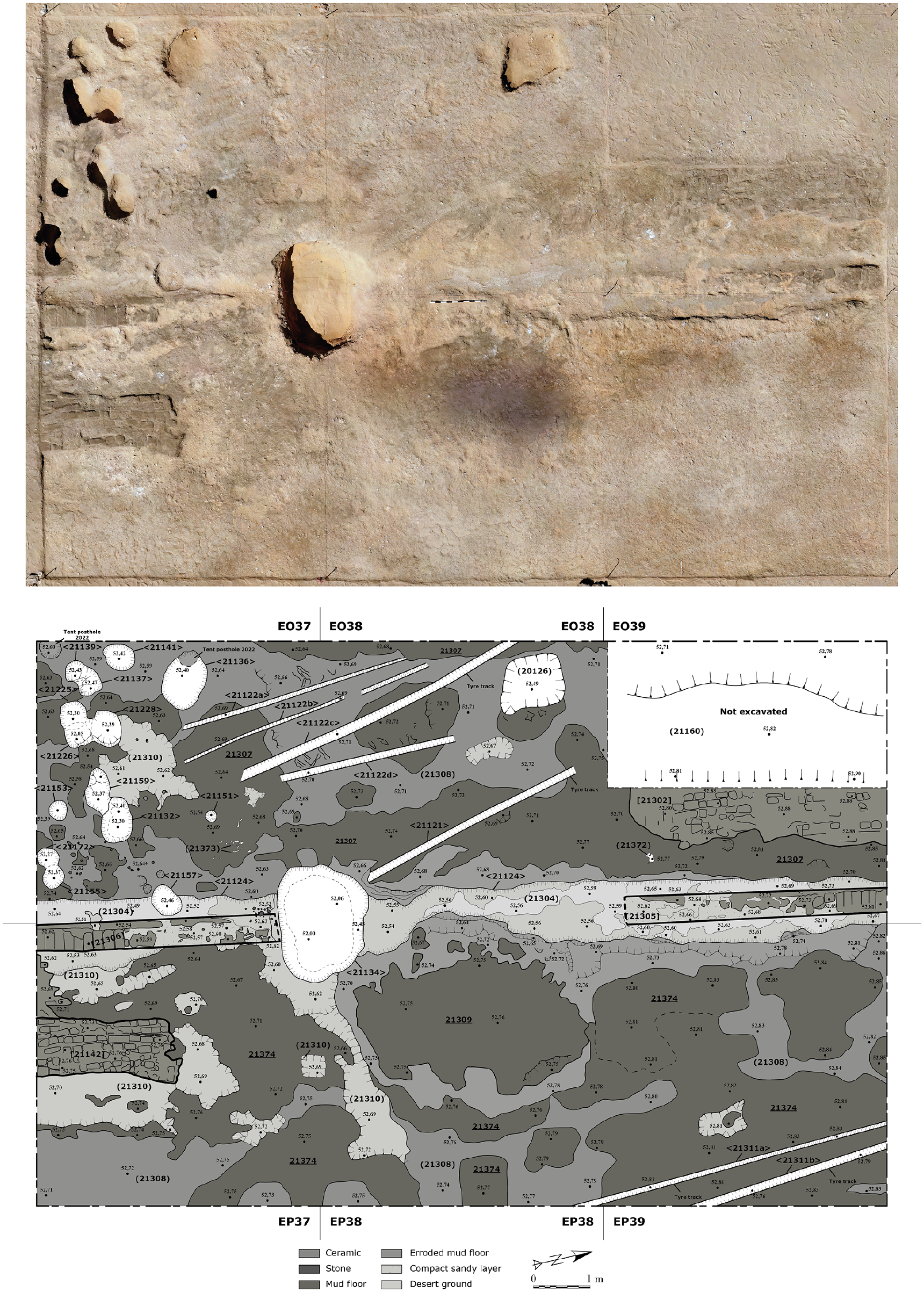
Top: orthomosaic of Sector 3 at the end of the work. North is to the right. Bottom: final plan of Sector 3 (images: Fabien Balestra, the Amarna Project).
The second sub-phase is represented by several structures in varying states of preservation. Wall [21305]/[21306] ran precisely along Pendlebury’s excavation trench (fig. 9), slightly angled north-west/south-east. This is the back wall of the Sanctuary. Built from dark mudbricks, either of standard or squarish shape, it was preserved to a single course. The north portion of the wall [21305] was 470 cm long and its south portion [21306] measured 419 cm. Their overall breadth was 52–54 cm. Both sections of the wall seemed to rest upon a mortar layer (21304) consisting of a greyish silt mixed with small pebbles. No foundation trench was visible, but the upper surface of the bricks aligns with the level of the internal and external ‘mud’ floors, suggesting that they might have been put in a very shallow trench.
These walls separated the interior of the Sanctuary from the ground between it and the Eastern Gateway. This delimitation was further perceptible in the nature of the floors west and east of the walls. Outside to the east, surface
The excavation also exposed seven pits to the south-west of wall [21306], with their complete number yet to be determined (Table 3). These circular pits intersected mud floor
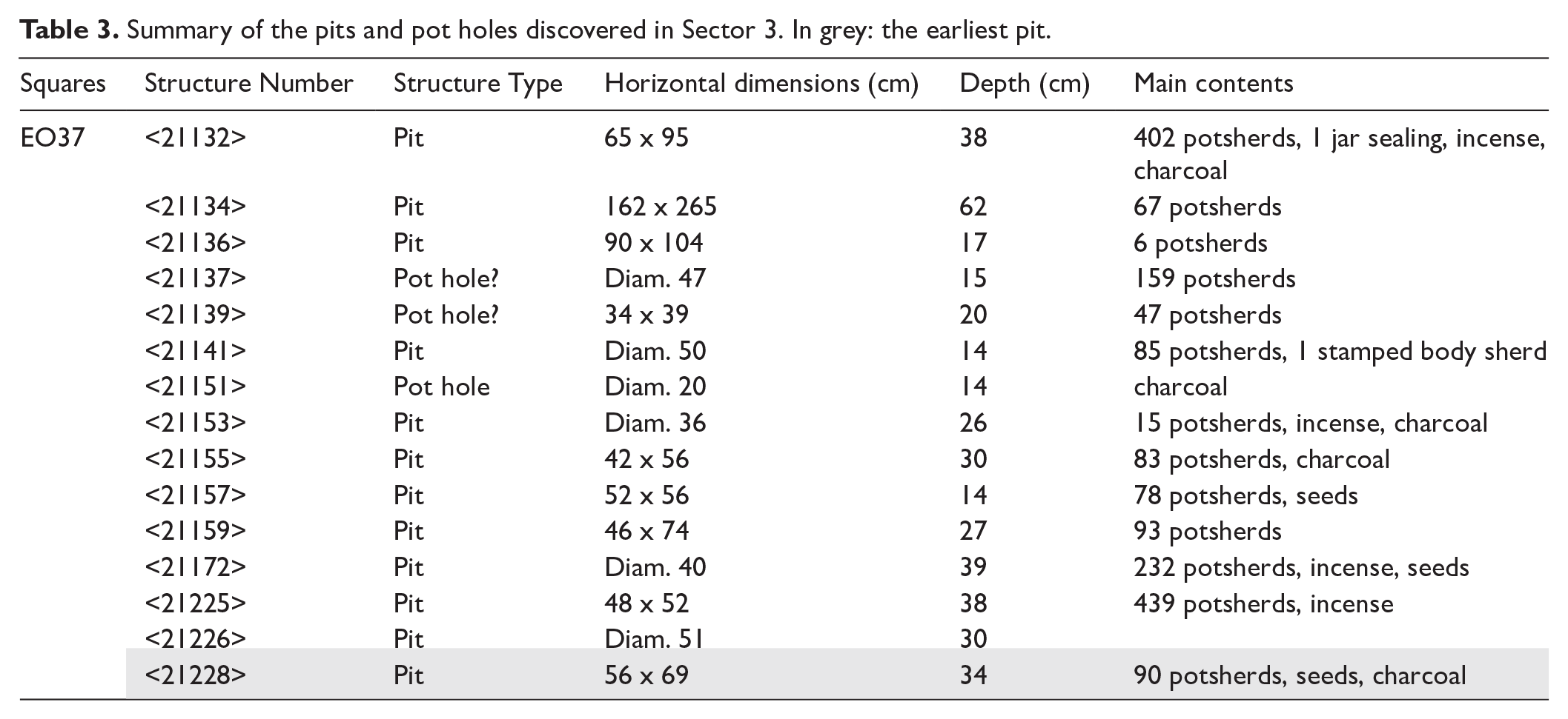
Summary of the pits and pot holes discovered in Sector 3. In grey: the earliest pit.
Post-Amarna Period
Quite soon after Akhenaten’s death, the temple probably stopped being fully in use, and was left unmaintained as an open quarry.
20
The desertion of the area was evident this season in the few layers of windblown sand deposited over time, including after the early EES excavation, which left the zone open to the elements. This part of the complex remains under considerable threat today from natural hazards, including strong rains and eroding winds, and foot and vehicle traffic. Stratigraphically, post-Amarna Period activity was represented by deposits of wall collapse. In Sector 3, the collapse of wall [21305] left a layer of structured bricks [21302] over a thin sandy deposit, which implies that a certain, indeterminable, period of time had passed before it fell. In contrast, brick collapse [21142] from the southern span of wall [21306] directly covered the trampled mud surface
Artefacts, pottery, and biological materials
The 2023 excavations again yielded many artefacts: pottery, worked stone, faience, metal, mud (jar sealings), and organic remains (charcoal, faunal bone, and others). The ceramics from 2022 and 2023 were washed, counted, and pre-sorted for study (see Gasperini and Rose, below). The quantity of pottery predictably surpassed that of other materials. This season also provided a group of incense-burner fragments, and a few pieces of charcoal with resin residues (and 14.17 g of raw incense). Blue-painted pottery is still barely represented in the East Gateway assemblage. Specific attention was dedicated to the 326 jar sealing fragments, though only a portion could be studied in the time available (see Bertram, below). The small finds were registered and photographed, while studies remain to be conducted, in particular, on the plant remains. A preliminary survey indicates the presence of carbonised and desiccated seeds (date stones, grapes) and cereal chaffs (emmer, barley, and perhaps flax). Photographer Andreas Mesli continued to document the materials excavated from the Great Aten Temple as a whole.
The pottery from the East Gateway and surrounding (V
Gasperini and P. Rose) 21 . The preliminary ceramic analysis for this season focused on ten contexts, excavated in autumn 2023. They derive from several of the pits identified in Sectors 2 and 3 of the East Gateway site: (21000) from pit <21001>; (20986) and (21144) from pit <21022>; (20987) and (21145) from pit <21146>; (21021) from pit <21022>; (21128) and (21224) from pit <21225>; (21171) from pit <21172>; and (21227) from pit <21228>.
The analysis showed a consistent repertoire, almost exclusively of vessels manufactured in Nile silt (Amarna Fabric I.1, corresponding to Nile B2 in the Vienna System). Most appear to be low fired (a thick dark grey core is in fact visible on many of them), they have a crumbly texture, and their finishing is quite careless. The repertoire is mainly composed of ‘beakers’; 22 bowls with ledged rims, 23 some preserving traces of burning, which is more pronounced on the interior; and small cups. 24 A cluster of small cups (some preserved intact or missing only a small portion of their bodies) was retrieved from context (21171); this seems to distinguish (21171) from others seen during this season, where cups are found in far less substantial quantities. Other types which appear to occur, in more modest numbers, are beer jars and blue-painted wares. The latter are all characterised, unsurprisingly, by quite a standard decoration of petal patterns.
At least three beakers (ceramic numbers: 161062, 161105, and 161106) seem to bear ‘ritual killing holes’, most likely produced by the pressure of a sharp pointed object, stabbed from the exterior to the interior, which resulted in the deliberate breaking of their surfaces. Interestingly, joining sherds belonging to beaker 161106 were identified in two different contexts, (21021) and (20986), suggesting the spreading of the broken vessel in two different pits.
Among the analysed contexts, (21000) stands out for containing a substantial number of amphora sherds (rims or rims with their necks), along with jar sealings and jar stoppers. Of the rims and necks, the vast majority were made from Fabrics III.2, III.3, and III.5 (Marl D in the Vienna System), III.9 (Marl F), and IV.3 (oasis clay). Interestingly, this context also yielded a number of small dishes, made from oasis clay, most likely used as stoppers for oasis amphorae. While oasis-clay small lids were also retrieved from other assemblages, amphorae rims have thus far been identified only from this context.
The jar sealings (M. Bertram) 25
In autumn 2023, 326 fragments of mud jar-sealings were recovered from the fills of ten pits that were cut in the ground between the East Gate and the back of the Sanctuary of the temple. There were 215 unstamped fragments and 111 stamped pieces. The final count of fragments does not represent the total number of sealings, since they broke into several parts when they were removed from amphorae. 26 The only sealing that was almost complete is object no. 44599: the top and about 3/4 of the lower part of the sealing survived in good, but slightly fragile, condition (fig. 10). It has five sharp, identical stamps, ‘Good Wine for the House of the Aten’. 27 For the first time during the excavations at the Great Aten Temple, sealings painted with blue pigment were recovered (fig. 10). Another novelty was the discovery of a sealing which had a small pottery bowl still attached on the inside (object no. 44600, with partial stamp, ‘wine…’; fig. 10). It served as a lid to prevent the contents from being contaminated with mud, and altogether ten similar bowls (unattached to sealings) were recovered from the pits. It remains unclear whether the pits, most of which also contained large amounts of broken pottery, were simply deposits of ancient waste or were dug for a different purpose.
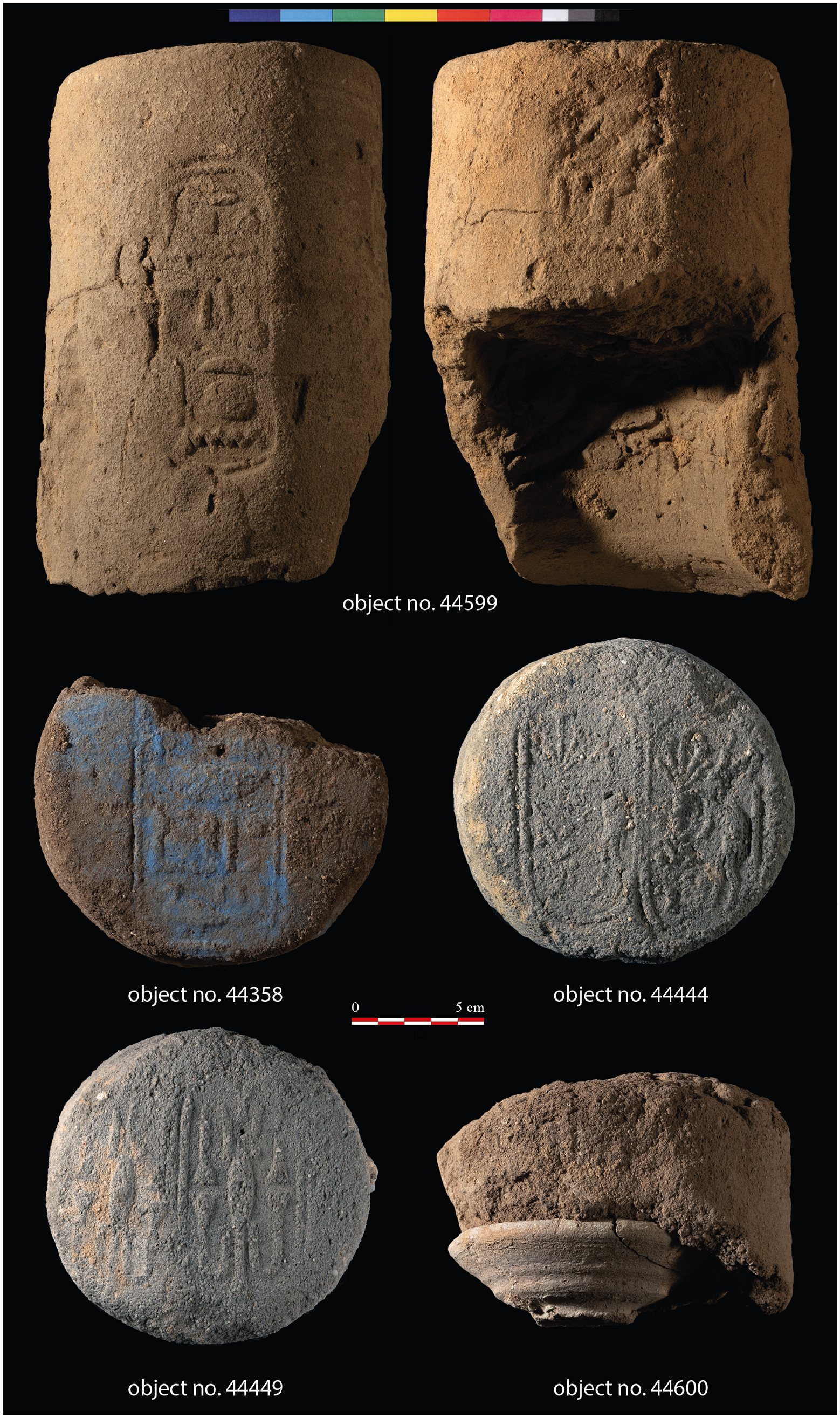
Selection of jar sealings found in 2023 (images: Andreas Mesli, the Amarna Project).
Rear of the Temple: Discussion
Ongoing investigations in Sector 2 demonstrated a consistent pattern in which pits gradually decrease towards both the north and the south, leaving an undisturbed trampled mud surface. The pits probably extend further eastwards. Two earlier pits and the probable wooden building constructed with posts indicate human activity before the muddy surface formation. Overall, this area provided a glimpse of the complexity of the archaeological site near the East Gateway, helping to shed light on the activities associated with various pits. Importantly, the findings definitively confirmed the occupation of the ground; however, contrary to previous assumptions, no levelling layer was identified.
Excavation in Sector 3 revealed the survival of the rear walls of the Sanctuary, which probably gave access to the East Gateway and its vicinity. Examination here further exposed pits and pot holes between these structures. Although their interpretation remains to be confirmed, the pits possibly represent disposal practices connected to activities related to the Sanctuary. This interpretation may also suit the similar pits in Sector 2. Further examination is needed to understand the connectivity across different sectors within the open temple grounds, and the external surroundings of the temple complex, not merely in terms of routes but also activity patterns.
Great Aten Temple Faience Inlay Project (S. L. Boonstra)
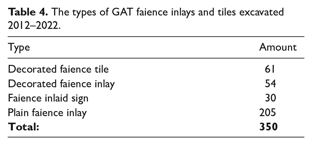
A study of the faience tiles and inlays discovered during the ongoing excavations at the Great Aten Temple (GAT) was conducted over two field seasons in spring 2022 28 and autumn 2023. 29 A total of 350 fragments of faience tiles and inlays were registered, catalogued, photographed, and examined. Below are the preliminary results of the examination.
Distribution of GAT faience inlays and tiles
The study corpus comprised the faience tiles and inlays excavated at the Great Aten Temple from 2012 to 2022. These seasons largely focused on the excavation of the western end of the temple enclosure and included the examination of the spoil heaps left from the initial excavations of the temple, particularly of the EES in 1932. The tiles and inlays originate both from the spoil heaps, where their original contexts are lost, and from previously unexcavated ground. The latter show a concentration in an area just east of the western enclosure wall, which coincides with the ‘Small Palace’ (fig. 11), the foundations of which were re-excavated in 2013. This 25 by 14.25 m structure was situated 1 m east of the western pylon, and was dismantled down to its first course of limestone talatats in antiquity. It may have once contained a throne and Window of Appearance based on its architecture and possible representations in the tombs of Panehsy and Meryra. 30 The distribution data strengthens an earlier hypothesis that the faience inlays were likely installed in either the floor or lower parts of the walls in the Small Palace. 31 The evidence for the original installation location will be studied further before final publication.
Plan of the Great Aten Temple, Grid 18 with the ‘Small Palace’ in the north-west (upper left) (plan: Barry Kemp).
Types of GAT faience inlays and tiles
The 350 faience inlays and tiles were broadly grouped into four categories: decorated faience tile; decorated faience inlay; faience inlaid sign (hieroglyph); and plain (monochrome) faience inlay (see Table 4). The distinction between a faience tile and an inlay is after Boyce, who characterised tiles as rectangular in shape 32 and bearing multiple elements of a decorative image or scene. In contrast, inlays were created in the shape of a specific object, such as a waterlily, bird, or fish, and were intended to be inserted into a larger decorative scheme. 33 However, since all of the studied pieces are fragmentary, the division between tiles and inlays is sometimes arbitrary. In contrast to the plain inlays, the decorated tiles and inlays are generally polychromatic.
The types of GAT faience inlays and tiles excavated 2012–2022.
Production of GAT faience inlays and tiles
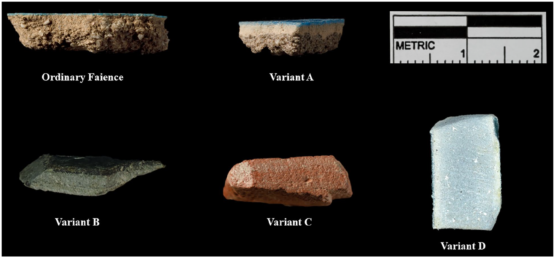
Although all of the inlays and tiles under discussion were made of faience (stone and the rarer glass inlays were excluded from this study), the production of these inlays varies. Five different ‘variants’ of faience were used, as well as at least two different forming methods.
Faience variants: Lucas originally proposed up to seven variants to ‘ordinary’ faience, which was later expanded on by Kaczmarczyk and Hedges. 34 The variants present in the corpus are Variants A–D (see Table 5).
The types of faience present in the GAT inlay corpus; those listed as unknown require further examination.
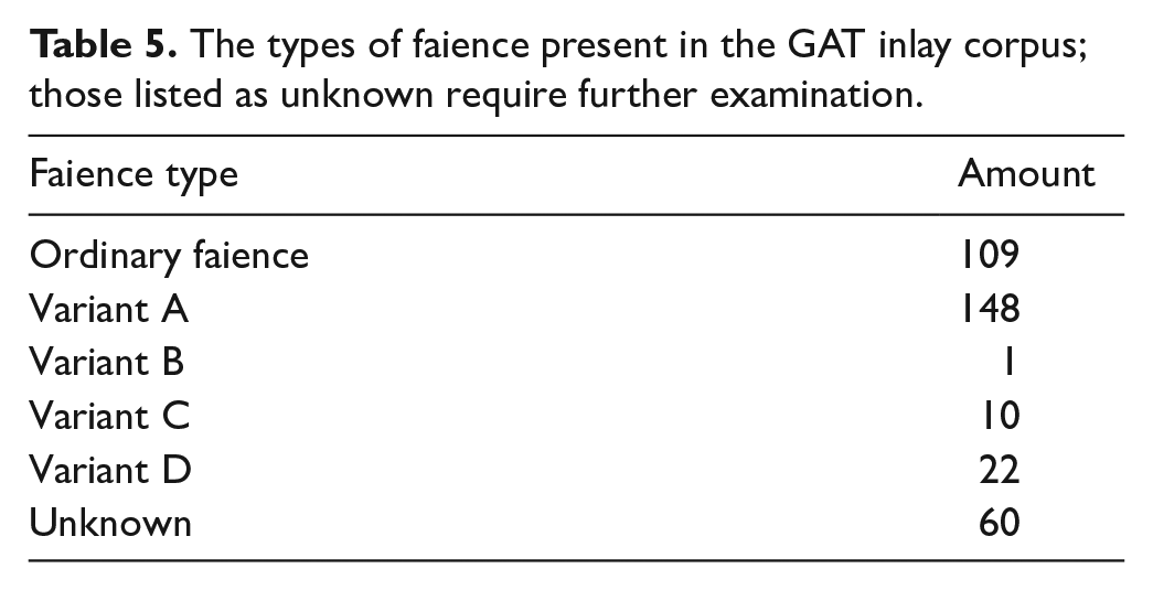
‘Ordinary’ faience is characterised as having a white or white-grey core of fine to coarse body material with a layer of coloured glaze on the exterior (see fig. 12). In contrast, Variant A faience bears a thin intermediary layer of very fine white or cream faience body material between the coarser body material and the glaze (fig. 12). Variants B to D are faience types in which the body material is fine-grained and does not bear the characteristic white or grey colour, but instead is the same colour as the glaze (although the shade of the core colour often differs from the glaze). The body material colour of Variant B is black, C is red, and D is dark blue (fig. 12). Some initial patterns regarding the use of the faience variants are apparent. The decorated inlays and tiles were primarily made of ordinary faience which often had a cream-coloured glaze that allowed painted decoration to be applied. Other decorated inlays and tiles, particularly those of plants, occasionally had segments of the glaze cut away to allow the insertion of other colours of paste (fig. 13). The majority of the inlaid signs were made of Variant D (dark blue) faience; nineteen out of the total 22 Variant D fragments are inlaid signs. The overwhelming majority of Variant A (intermediary layer of faience) examples (116/148) were the ‘plain inlays’; i.e. undecorated, monochromatic inlays.
Faience variants present in the corpus: nos 41286, 41288, 43308, 41287, and 40051 (photos: Andreas Mesli and Stephanie Boonstra).
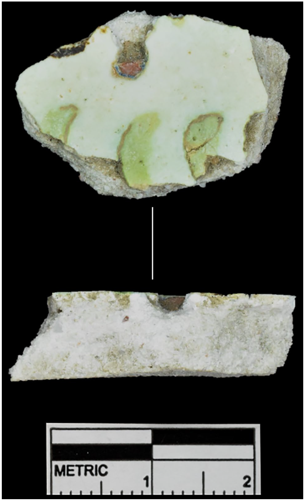
Poppy faience tile fragment, no. 40237, showing the insertion of red faience for the bud (photo: Stephanie Boonstra).
Further research into the uses and production of the faience variants will be conducted before full publication.
Forming methods: There appear to be two main ways in which the faience tiles and inlays were formed – individually modelled or cut from ‘parent’ tiles. The former method was used for the creation of the decorated inlays and tiles and the inlaid signs. Some appear to have been placed on a textile surface before firing, due to the presence of a textile pattern on the base of the fragment.
The latter method involved the faience being shaped into a large flat tile. After firing, these ‘parent’ tiles were then reduced to smaller shapes by grinding linear grooves into their reverse, along which they were then snapped. 35 Some of the fragments in the corpus still bear groove marks from where a snap was abandoned. Many pieces are too fragmentary to definitively ascertain their formation method. However, many of the plain inlays appear to have been cut from a ‘parent’ tile; Variant A faience was often, although not always, used for inlays shaped in this way. It is hypothesised that this was because its coarser body material was easier to abrade to snap to size and the inclusion of the intermediate layer of fine faience allowed an even glazing surface (ordinary faience over coarse body material results in an irregular glazed surface), so that the brilliance and evenness of the glazed surface was not sacrificed.
Further research on the GAT faience inlays and tiles
Before final publication, further research will be conducted into 1) the production of the inlays, including forming methods and faience variants; 2) the usage of the different faience variants; 3) the find contexts of the inlays, particularly those found in secure contexts (which is unfortunately the minority); and 4) the design parallels discovered in the Amarna workshops and other palaces.
Housing Project: Protecting Amarna’s Urban Heritage (A. Stevens)
Background
Autumn 2023 saw the launch of a three-year pilot project entitled Akhenaten’s City: Protecting Amarna’s Urban Heritage. Funded by the American Research Center in Egypt’s Antiquities Endowment Fund (USAID), the project centres the survey, recording, and protection of Amarna’s mudbrick houses. In 2023, the team comprised Anna Stevens, Melinda King Wetzel, Wendy Dolling, Sarah Ricketts, Tracy Lakin (archaeology); Paul Docherty (digital archaeology); Gemma Tully (community archaeology); Amélie Deblauwe (photography); Alice Salvador (illustration); with fieldwork assistance provided by Waleed Mohamed Omar, Ahmed Mokhtar Mahmoud, Abdel Hafiz Abdel Aziz, Abdel Malek Mohamed, Mohamed Saleh Osman, Bakr Amin Abdel Rakhman, Abu Zeyd Ezz El Din, Mohamed Rabia Fatih, Mohamed Mahmoud Mohamed, Shahata Mohamed Sayed, Yahya Sadiq Abdel Fattah, Ahmed Sayed Nassar, Mahmoud Bakr, Arabi Abdel Sabour, Ahmed Mezagher, Mahfouz Mahrous, and Mohamed Abdel Sittar.
Houses form the bulk of Amarna as an archaeological site, and contribute much to its value as a heritage place. It has been estimated that Akhetaten had around 3000 houses, 36 grouped mostly in large residential zones today labelled the Main City, North Suburb, and North City (fig. 1). Around 1000 of these houses were cleared during large-scale excavations in the early 1900s (fig. 14) by the Deutsche Orient-Gesellschaft (DOG; 1911–1914) and EES (1921–1936). 37 Since fieldwork resumed in the 1970s, around fourteen houses have been investigated using modern techniques, 38 while several hundred houses remain unexcavated, mostly through the western part of the Main City (fig. 1).
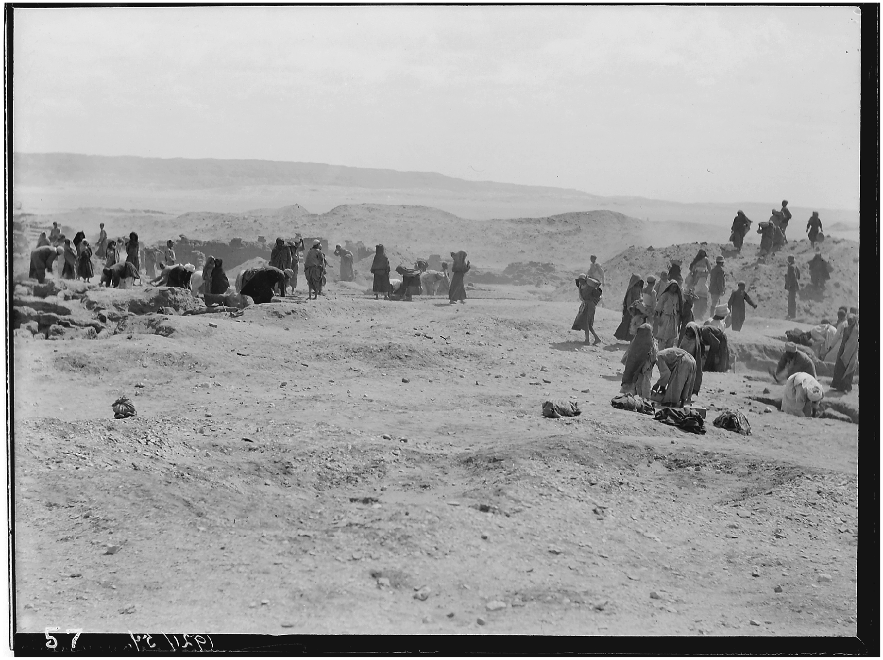
A view of the EES-led excavations in the Main City in 1921, showing the kind of poorly controlled and large-scale clearance that was generally typical of archaeological excavations of the time (EES.TA.NEG.21.057; courtesy of the Egypt Exploration Society).
Amarna’s ancient housing areas are under increasing threat from exposure and from modern urban encroachment and its side-effects, such as rising ground water. In recent years, the growth of regional transport networks and rural development projects have placed unprecedented strain on the site. The threats to Amarna’s heritage are exacerbated by the fact that its boundaries are poorly demarcated, and its archaeological deposits are shallow and easily destroyed. Archaeological fieldwork has also left a complicated legacy. Most of the houses excavated in the early 1900s were left uncovered, and in the intervening years they have been gradually eroding away. Archaeological expeditions to the site have also done little, overall, to engage local communities, and partage removed much of the site’s portable heritage. Today, heritage professionals face an enormous challenge in protecting an expansive mudbrick city that lies, for the most part, open and exposed on the desert plain, while balancing the needs of the c. 30,000 people living on and around the archaeological site. 39
There has been little investment in strategies to protect Amarna’s ancient houses. Most preservation projects have focused on its tombs, temples, and palaces; conservation of the houses is complicated by their large number. Backfilling projects would ideally use the spoil heaps left by the early excavators, but these would require slow stratigraphic excavation to retrieve and contextualise the artefacts and environmental materials they contain. The lack of a stable research/conservation budget for the site is also a major factor.
The AEF project introduced here centres the idea that heritage with demonstrable benefit has a greater chance of long-term survival, and asks how Amarna’s housing suburbs can become sites of increased, and more positive, engagements. On a day-to-day basis at Amarna, few people interact with the ancient houses and the heritage they represent. Tourists might stop quickly at one partly reconstructed house near the Small Aten Temple (Q44.1), but see little else of the housing suburbs, and there are few resources available for the wider public. For local communities, interactions with the houses are often negative, characterised by disagreements over land use. Researchers, meanwhile, rarely come to Amarna to study the houses directly, relying instead on excavation records, including the extremely patchy publications of the early fieldwork. The AEF project seeks to prolong the survival of Amarna’s urban heritage by developing and starting to implement strategies to transform the houses into more effective assets for research, education, outreach, and tourism, in conjunction with direct protection initiatives. The project has four main elements which, in part, build from recent community archaeology and photogrammetry projects. The first is a programme of photogrammetry and on-site recording in the Main City. The goal here is to generate a large-scale landscape model of the Main City, and digital models of a sample of houses excavated in the early 1900s, while also re-recording the archaeology and architecture of the sampled houses. The second element is the construction of protective walls at particularly vulnerable parts of the site, to give greater clarity about boundaries and prolong the time available to archaeologists to study these areas. The third is a programme of community archaeology and outreach, intended to include local voices in the work and continue to develop the Amarna Visitor Centre as a hub for community engagement. The fourth element is targeted conservation of the house of the vizier Nakht, which was once a well-preserved villa, 40 but is now heavily threatened by modern urban growth. Outputs will include on-site infrastructure (e.g. protective walls, information panels), digital heritage assets (e.g. large-scale landscape and house models), and outreach resources (e.g. teaching guides for the Visitor Centre). The project will also generate a range of data that will inform on the condition of the site and threats it faces, stakeholders’ relationships with Amarna’s housing areas, the nature of the early excavations and reliability of their field records, and the urban nature and later history of Akhetaten itself.
2023 field season and post-season work: Results
The first season of on-site work ran from 3 November to 17 December 2023, and focused on the photogrammetry and on-site recording, and a Community Open Day at the Visitor Centre. In June 2024, construction of the first of two planned boundary walls was undertaken. A brief report on the survey work and wall construction follows, and a description of the Open Day is provided by Gemma Tully below.
Landscape and housing survey
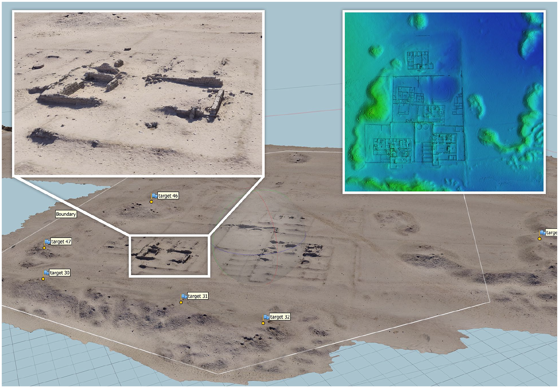
The landscape and housing survey began in the southern part of the Main City, and continued northwards along the wide ancient street named by excavators East Road South, taking in parts of grid squares M50–51, N49–51, and O49–51 (fig. 15). The desert here is flat overall, criss-crossed by modern tracks, and dotted with large mounds of spoil left by the early excavators. These spoil heaps generally occupy open external areas of the ancient city; there is a large group along East Road South. Between the spoil heaps, the mudbrick walls of larger houses excavated in the early 1900s break the surface, the lower parts of the buildings being still covered in sand and rubble. Smaller houses and other structures (courtyard walls, etc.) tend to be visible only as low ridges of powdery degraded mudbrick. It can be challenging to match the visible remains with the plans of buildings excavated early last century, although on the whole individual structures can still be identified. Mid-to-large-sized residential estates dominate the east side of East Road South, while small-to-mid-sized houses tend to lie to its west, often clustered together. The study area also incorporated two very large circular structures, possibly wells (M50.17 and 18), and a large granary (O51.1) on the far eastern outskirts of the Main City. 41
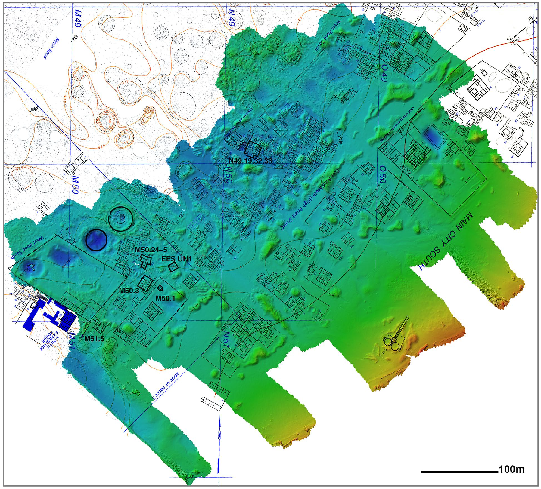
The extent of the photogrammetric landscape survey conducted during the 2023 season. The Amarna survey map sheet no. 7 (Kemp and Garfi 1993) has been overlaid to show the 200 m grid system and the location of ancient structures. The structures with bold outlines are those that were re-cleared and re-recorded (image: Paul Docherty, Amarna Project/Amarna3D).
The first extensive clearance of this part of the Main City was undertaken by the DOG in 1911 and 1912, who targeted the larger estates. They excavated the houses along the eastern side of East Road South and, on its western side, estate M50.1 and some other houses along the street front. 42 Between 1921 and 1925, the EES undertook further clearance along the western side of the street. 43 Overall, the DOG team generated house plans and written architectural descriptions that were relatively detailed for the time, while the records from the EES work here are more abbreviated; they left a number of buildings in grid squares M50 and N50 entirely unplanned. 44 Both teams of excavators provided very limited information on artefacts (particularly the DOG), and almost nothing on stratigraphy, landscape, environmental materials, or the construction, use-lives, and wider environs of the houses.
Photogrammetric survey (P. Docherty)
The photogrammetric survey consisted of two parts. The first was a terrestrial-based landscape survey to record the current preservation of the ancient structures. This will provide a base from which to monitor the structures over time. As the photogrammetric survey progressed, a sample of houses excavated in the early 1900s was selected for detailed archaeological/architectural re-recording, necessitating clearance of deposits that had accumulated within them. The second part of the photogrammetric survey conducted detailed captures of the cleaned structures, after the initial landscape survey had been completed.
The landscape survey used a video capture method which allows for rapid capture of large areas using a small 4 k resolution camera with a built-in gimbal (DJI Osmo Pocket) mounted on a 3.5 m telescopic pole. The captured footage was pre-processed into a format acceptable for use in the photogrammetry software (Agisoft Metashape) and the area was further processed into 3D model and digital elevation model (DEM) formats (fig. 15). The landscape survey began close to the dig house and progressed northwards in strips. Captures were conducted at the same time each day to maintain consistency regarding light and surface colour. A two-hour capture was able to be processed at a low resolution overnight to ensure the data was good before proceeding to the next capture area, as shown in figure 16. At the end of the season, the landscape survey produced 136,000 images covering approximately 21 hectares (21 x 100 m squares) with a potential resolution of 3 mm per pixel for the DEM data. Figure 17 showcases three examples of structures captured from the landscape survey. The presence of packs of dogs led to several problems during capture, resulting in some gaps on the eastern edge of the survey.
An example of a single day’s capture using the video method resulting in approximately 1 hectare (100 m square) of landscape (N50.1, N50.2, and N51.3–9). Left inset shows the level of detail acquired and right inset shows the pseudo-colourised height map of the same area with Borchardt’s Plans 109–110 overlaid (Borchardt and Ricke 1980: plans 109–110) (images: Paul Docherty, Amarna Project/Amarna3D).
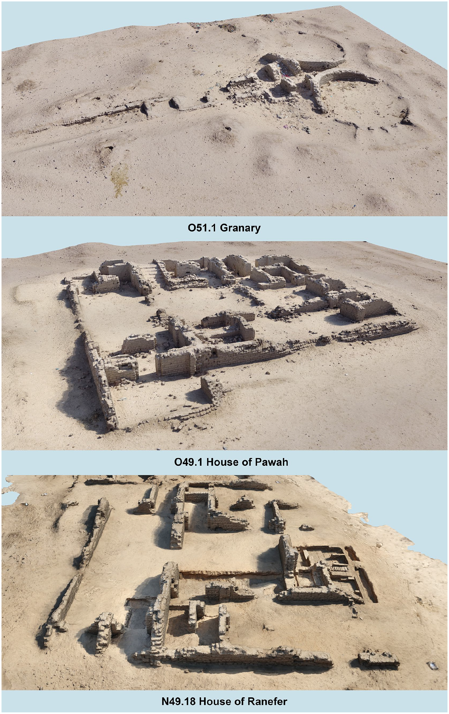
A selection of 3D models extracted from the photogrammetric landscape survey (perspective views not to scale). O51.1 and O49.1 are not among the structures that were re-cleared this season, and only sample areas of N49.18 were cleared (images: Paul Docherty, Amarna Project/Amarna3D).
The detailed structural surveys were conducted using a Canon R7 mirrorless camera. As the purpose was to capture a fine level of detail, the number of images taken was deliberately high to ensure all surfaces were recorded. The resultant 3D models were processed overnight to ensure the data was good and that no further remedial capture photos would be required. The detailed surveys produced 22,500 images for the targeted structures, which are discussed below. Figures 18–21 showcase some of the detailed captures.
Orthographic view of House M51.5 showing a secondary burial in the central room (images: Paul Docherty, Amarna Project/Amarna3D).
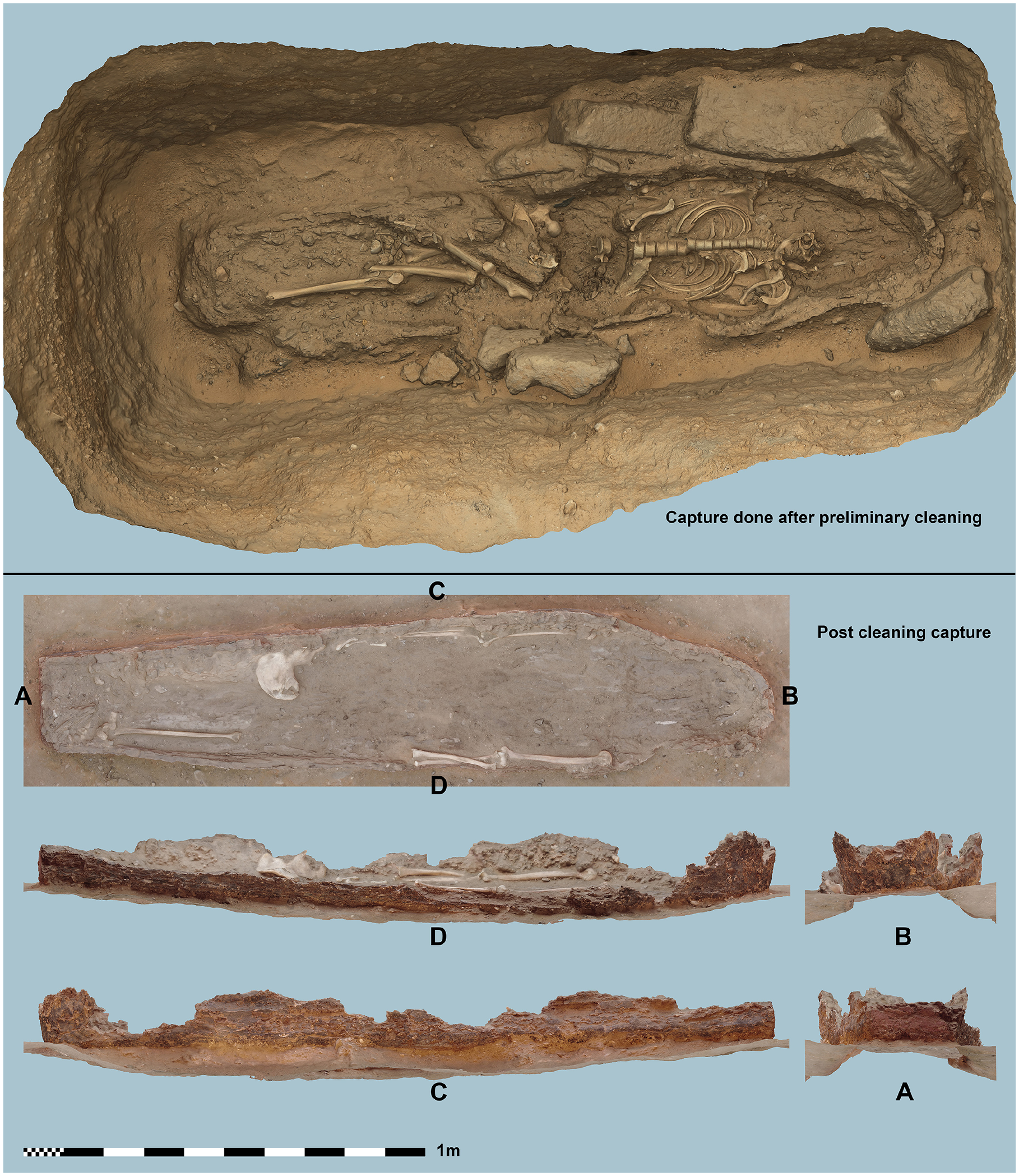
Orthophotos of the central burial in House M51.5. Top view shows the burial after a preliminary clean while the bottom views show the coffin remains after cleaning and lifting of the skeletal remains (images: Paul Docherty, Amarna Project/Amarna3D).
A selection of 3D models constructed from the detailed photogrammetric captures of the cleaned structures (perspective views not to scale) (images: Paul Docherty, Amarna Project/Amarna3D).
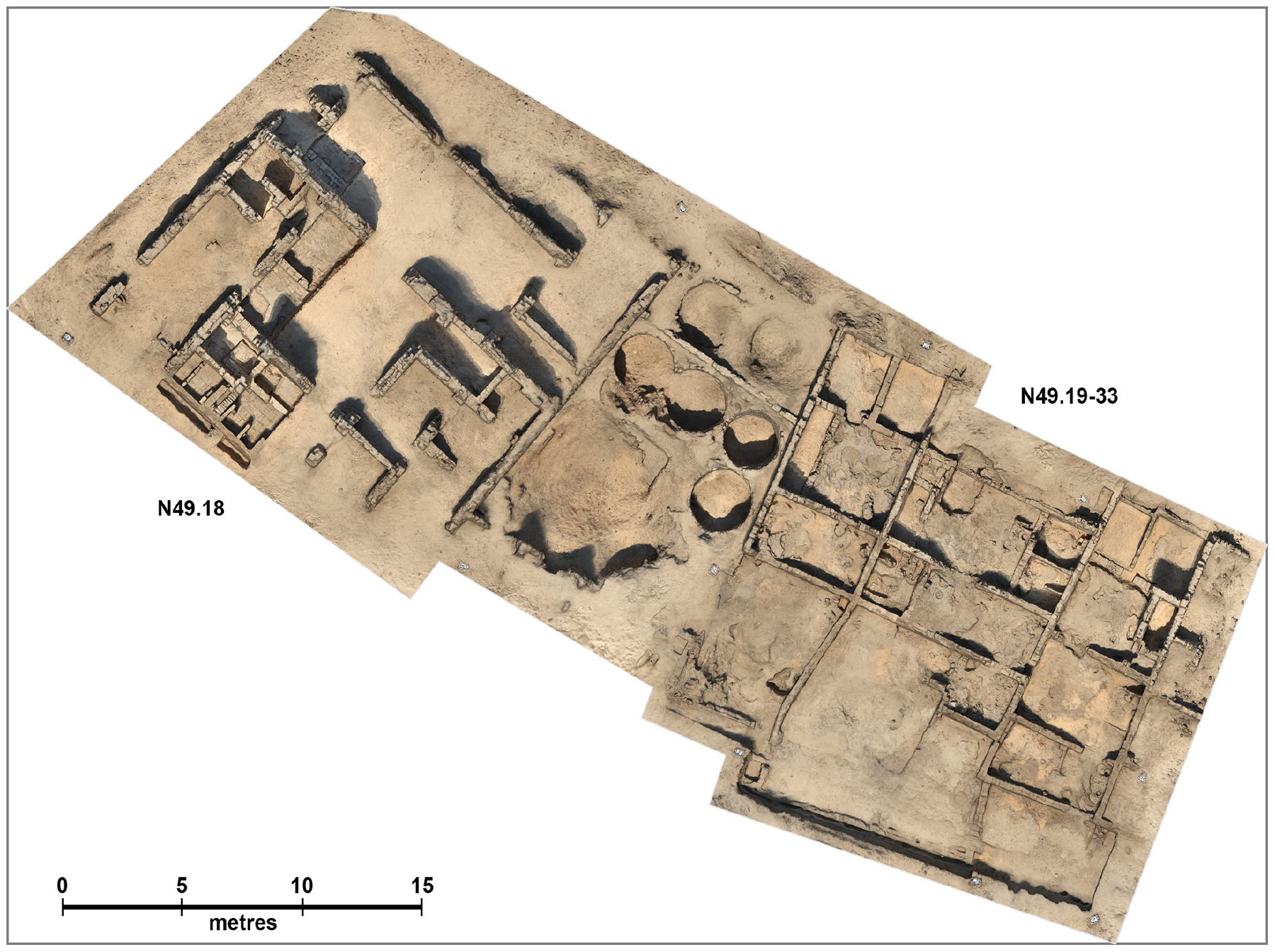
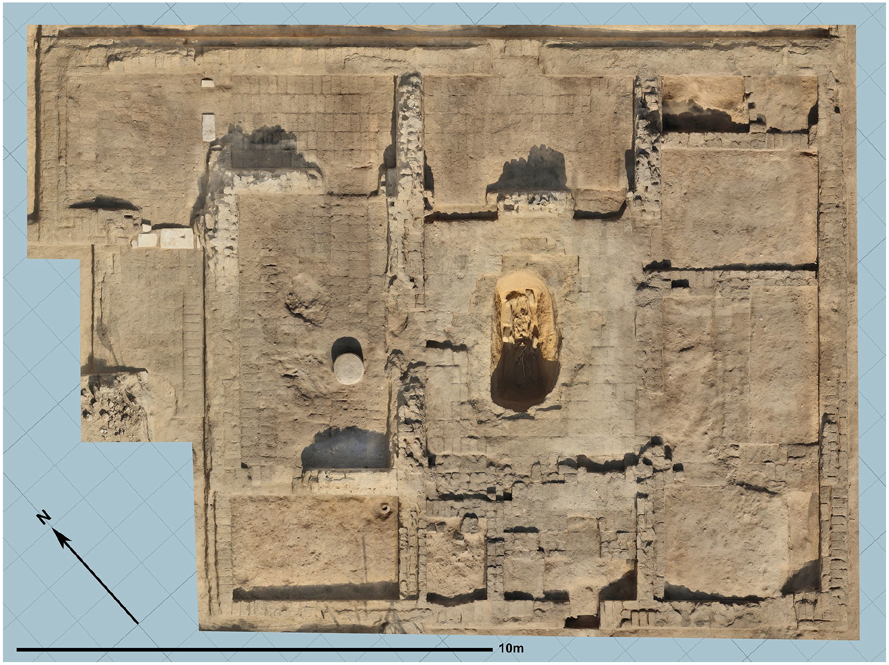
Orthographic view of the house of Ranefer N49.18 and connected buildings N49.19–33 taken from the detailed photogrammetric study (images: Paul Docherty, Amarna Project/Amarna3D).
To geolocate the survey data, 121 coded marker targets were positioned around the site and surveyed by local surveyors. This was completed in two batches, with the first set of markers recorded using GNSS and the second set by Total Station. All the data recorded during the season was processed at the lowest level on-site to ensure data fidelity, with subsequent re-processing at a higher resolution and cleanup post-season (January to March 2024). The final 3D models will be further processed by reducing their polygon count and surface texture size to optimise online viewing while maintaining a balance between file resolution and fidelity of the individual structures. These models will then be made available on the Amarna 3D website towards the end of the project. 45 The resulting 3D data acquired from the photogrammetric survey has the potential to inform various conservation issues, such as areas of human and animal movement, and environmental changes, such as water level, across the landscape.
Archaeological recording of the houses
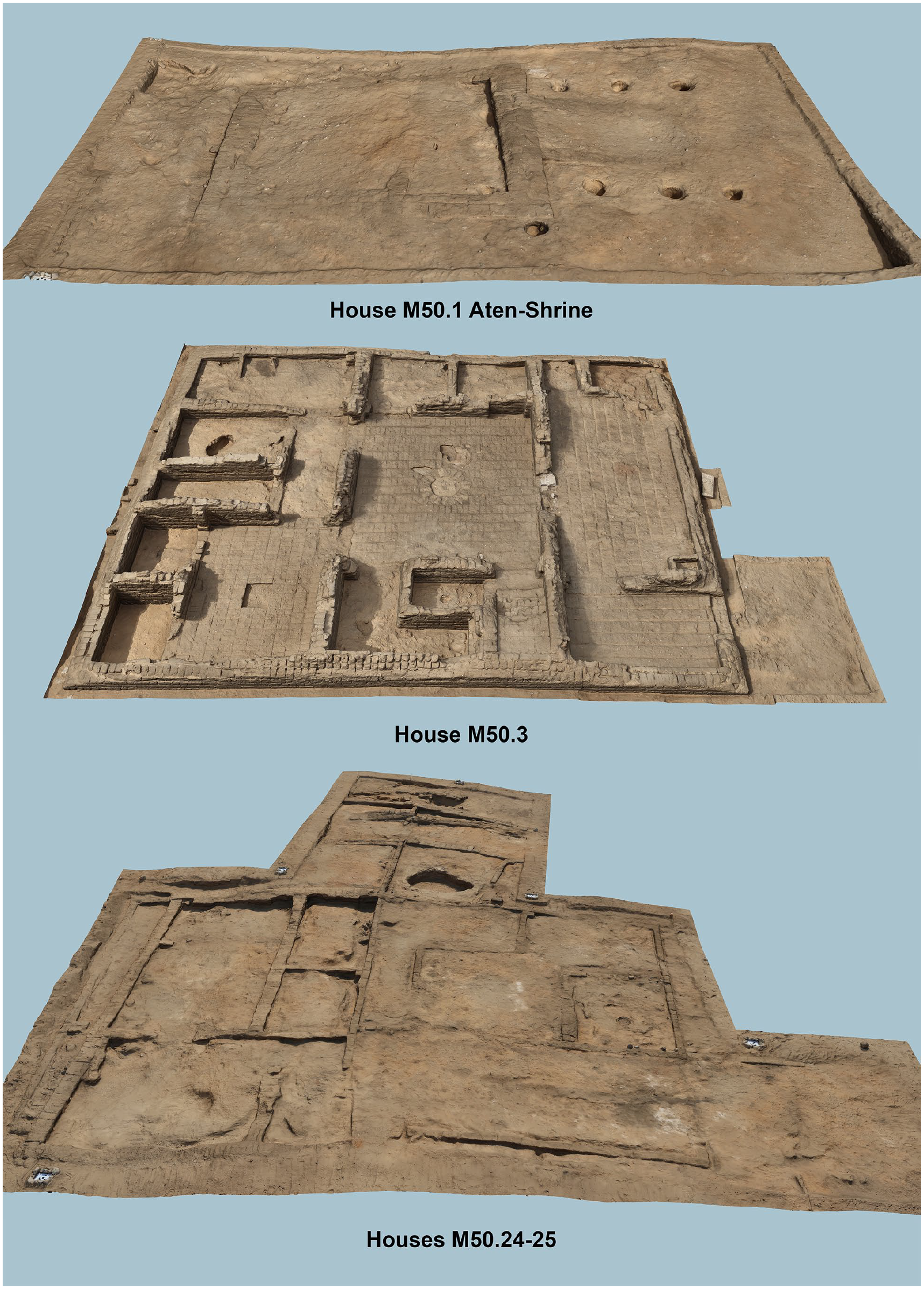
By the end of the six-week season, nine structures had been partly or fully re-cleared and re-recorded (figs 15, 18–21). We sought to sample buildings of a range of sizes, types, and locations to understand their condition and to generate variety in the digital models. The sampled buildings included two relatively large houses, M51.5 and M50.3, first excavated by the DOG in 1911 and 1912 respectively (figs 18–20). 46 The re-clearance of these buildings was relatively straightforward, involving the removal of sand and brick rubble down to floor level. It was not feasible to re-plan the buildings in the time available, but a feature-by-feature description was made of the architecture to supplement the records left by the DOG; the recording of M50.3 remains to be completed in 2024. A feature in M51.5 was a grave cut through the brick floor of the central room, in a location where a column base must originally have stood (figs 18–19). The DOG excavators photographed the top of the grave, and described it as an intrusive burial, but gave little further detail. 47 We re-cleared the grave, and found the skeleton still in situ in an anthropoid wooden coffin, preserved through its base and lower walls. The coffin bore a black-painted exterior, with red paint covering the outside of the footboard, but there was no sign that decoration had been added over the painted ground. In the left hand of the skeleton, there was a steatite scarab decorated with a royal figure worshipping an obelisk (object no. 44802; fig. 22). The interment probably relates to ongoing occupation at the site after it was abandoned by the royal court, 48 and may fall within a few decades of this event, 49 with black-painted coffins thought to have been largely confined to the reigns of Hatshepsut to Ramesses II. 50
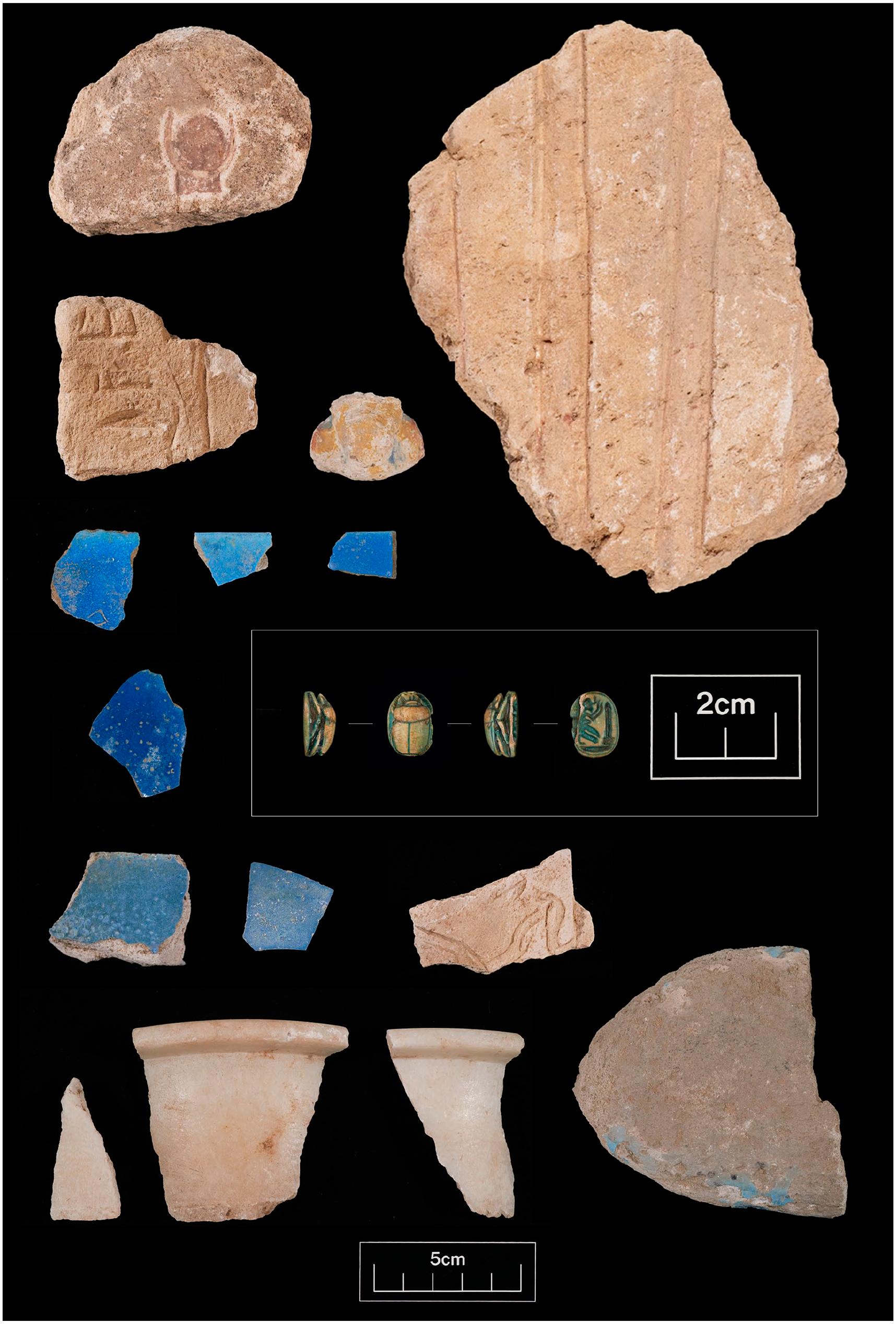
A sample of artefacts recovered from house M51.5. The scarab was found in the grave in the centre of the house. The remaining objects are all likely to have been deposited in the house by one of the teams of early twentieth century excavators (photo: Amélie Deblauwe, Amarna Project).
The landscape survey took in a ‘garden shrine’ at estate M50.1, excavated by the DOG in 1911 (fig. 20). 51 The early records of these structures, where the Amarna royal family, and perhaps private ancestors, were worshipped, are generally poor, and the opportunity was taken to clear, re-record, and re-plan the shrine. It survived to foundation level, comprising a rectangular enclosure for a platform, and an approaching staircase or ramp. One of its corners was badly damaged by a trampled path. Excavation either side of the staircase/ramp exposed six pits filled with dark silty deposit, presumably ‘tree pits’, all of which had been overlooked by the DOG excavators.
The sampled buildings also included several smaller houses. Houses M50.24 and M50.25 (fig. 20) were cleared by the EES in 1924, but only rapidly planned and recorded. 52 Both survived to only a couple of courses of brick, but re-recording captured many more details than were marked in the original plan, including evidence that M50.25 was built over the levelled remains of an earlier building. The opportunity was also taken to re-clear an area immediately south of these two houses, where the early EES plan marked a gate-like feature in a possible street. The excavation enabled us to re-identify the feature as the likely remains of one or more houses that had been purposefully demolished, with a thoroughfare created through part of the levelled space. Three small-to-mid-sized houses, N49.19, N49.32, and N49.33, immediately south-east of the house of the Chariotry Officer Ranefer (N49.18), were also re-cleared and re-recorded (fig. 21). This work will continue in 2024. These houses had been excavated by the EES in 1921. 53 They survived to a much greater height than M50.24 and M50.25, although multiple courses of brickwork still seem to have been lost since they were first cleared.
Finally, the archaeological work included a building in grid square M50 that is one of several that were rapidly cleared by the EES in 1924, but never planned or published. 54 We cleared the windblown sand and rubble, exposing a rectangular complex measuring c. 11 x 10 m. Its northern end contained three small rooms, while much of the rest of the complex may have formed a large courtyard, although it was extremely denuded and its features were difficult to resolve. The complex seems to have been erected over a gully, which was filled to create a more even surface for the construction of the building. A large pit was subsequently cut, possibly during looting or digging for sebakh in recent centuries. The EES excavators had left, or only partly excavated, many of the ancient deposits in this building. We excavated what we could of these in the time available, to enable a top plan to be produced of what remained of the complex.
As the survey progressed, loose brick samples were collected for environmental and other analyses, and pottery and artefacts were likewise collected from the re-cleared buildings. The method of finds collection varied according to the nature of the deposits. Where these were clearly windblown sand that post-dated the original excavations, they were usually removed without sieving. More complex deposits were all sieved. Substantial quantities of potsherds were recovered, and a strategy for recording these is being developed. A summary of the recovered artefacts follows.
Artefacts from the housing survey (T. Lakin)
The season yielded a diverse artefact record, numbering around 490 pieces. The re-cleared buildings produced varying numbers of artefacts, recovered mostly in the windblown sand and rubble fills, as follows: M51.5 (157 artefacts), M50.3 (52), garden shrine (5), M50.24 (10), M50.25 (14), ‘street space’ (7), N49.19 (86), N49.32 (39), N49.33 (36), and the unnumbered house in M50 (84).
These artefacts will have had varied origins. While many are likely to be intrusive, some were recovered from low down in the fills, on or just above floors, and along junctions between the walls and floors, and likely relate to activity in the house in which they were found. The number of finds from M51.5 can be noted. As this house was cleared, unexpectedly large numbers of artefacts were encountered, some in the corners of rooms, and in concentration in the upper fill of the grave in the central room. They included pieces of carved relief, faience vessel and tile fragments, pieces of alabaster vessels, and a fragment of a faience model fish (fig. 22). Many seemed too large and/or distinctive to have been simply overlooked when the house was first excavated. The discovery of two pieces marked with registration numbers confirmed that M51.5, which lies just beside the southern dig house, had been used as a place to cache excavated artefacts. Another, larger, cache of pottery and artefacts left by the early EES and DOG teams was found in 2002 in a nearby set of ancient granaries and magazines. 55 It is not yet clear which team of excavators deposited the finds in M51.5, and where they were originally found, although the registration number on one of the two marked-up pieces (a travertine vessel fragment) seems to bear house number ‘M50.15’, a building that was excavated by the EES in 1922. The other marked-up piece, a probable limestone mould for a pendant in the shape of a disk and horns/crescent, bears a black ink figure that seems to read ‘.600’, ‘.606’, or similar. An initial survey of the EES archival records and published volumes, and the DOG excavation report, has not yet provided obvious matches for these two pieces, raising the possibility that they were discarded without having entered the site records at all.
The bulk of the assemblage from the survey as a whole consisted of jewellery items: faience and glass beads, pendants, and finger rings, including a carnelian bezel inscribed with the name of Nefertiti (object no. 44604). The steatite scarab with an image of a king worshipping an obelisk has been noted above (object no. 44802). Evidence of jewellery production comes from moulds recovered from M51.1, N49.19, N49.32, and N49.33. Glass-making debris (ingots, rods, ribbons, saggar fragments) was recorded across M50.3, the unnumbered house in M50, N49.19, N49.32, and N49.33. Faience tiles are a prominent component of the assemblage, recorded across all of the re-cleared structures. Fragments of faience vessels also occur.
Limestone furniture pieces included large sections of tables or stools, with six examples from M50.3 and M51.5, and one from the unnumbered house. The work also yielded probable architectural elements, primarily in the form of worked sandstone and limestone, sometimes with gypsum plaster, from M50.3, the unnumbered house, M51.5, N49.19, and N49.33. Three blocks with traces of relief were among the finds recovered from M51.5. The remaining artefacts comprised weights, metal needles and corroded nodules, stone tools, reused sherds, spindle whorls, stone vessel fragments, a few pieces of textile, jar seals, quernstones, possible figurines, incense/resin lumps, pigment blocks, a few samples of leatherwork, a figurative ostracon, mineral samples, a piece of worked wood, and some loose pieces of painted gypsum plaster.
The artefact assemblage recovered has a ‘domestic character’ overall and is represented in residential contexts elsewhere at Amarna. 56 Future work will allow for it to be fully recorded and analysed in terms of what it adds to knowledge on activity patterns at Akhetaten and the nature of the early excavations.
Housing survey: Discussion
In this first season, the priority for the survey was to establish and refine methodologies. While there were challenges in balancing the pace of the landscape survey with the slow nature of archaeological recording in the re-cleared houses, the survey provided an opportunity to engage with Amarna’s urban areas on a scale that has not been undertaken in many decades. It is clear that the survey will provide substantial data on the condition of the houses, threats to their survival, and stakeholders’ interactions with the site. Unsurprisingly, the survey demonstrated the variable degree to which houses have been preserved, with larger, well-built houses surviving in much better condition than smaller houses built with walls a single brick wide. The task of quantifying, analysing, and presenting these threats, interactions, and losses remains, and the landscape model has great potential as a tool to facilitate this.
The re-clearance of the houses added new data on the urban nature and development of Akhetaten itself, and its later history. Preliminary themes to come out of the work include the degree of modification that could take place to the natural landscape before houses were built, and the modification of buildings during the occupation of the city itself, seen particularly at and around houses M50.24 and M50.25. These are the kinds of details – of adaptations to landscape and urban growth – that are largely missing from the early excavation records. The burial in house M51.5, meanwhile, could hint at a secondary phase of occupation in which high-quality burial containers were still sought, but the skills and/or resources to decorate coffins were no longer as readily available, while elements such as wooden columns were being repurposed from the standing houses. The work also produced important data on the nature of the early excavations, with additional evidence for the caching of artefacts (perhaps, even before their study), a further chance to compare early field records with those from modern work, 57 and insight on the mechanics of this fieldwork and its impacts. The chaotic nature of much of the early work was particularly evident at the unnumbered building in square M50.
Construction of a boundary wall at El-Till
The AEF project also includes budget for the construction of two boundary walls to protect vulnerable areas of Amarna, and in June 2024, the first wall was constructed. It comprises a c. 300 m long wall built along part of the south-east outskirts of the town of El-Till, where farmland is gradually encroaching onto state-owned Antiquities Land and damaging ancient houses in the North Suburb, one of the more vulnerable parts of Amarna. 58 Consultation with local farmers was made by MoTA staff before construction, and the impacts of the wall will be monitored going forward.
Housing project: Final observations
While the task of protecting Amarna’s houses is a long-term challenge, the first year of this pilot project has established methodologies that blend archaeological research, heritage management, and public engagement. It also demonstrated the great potential that work on Amarna’s houses has to generate content and resources that engage a wide range of audiences, as is outlined below.
Community Engagement (G. Tully)
In 2023, community-centred activities took place on-site during the autumn field season and in Mallawi in June, while the development of resources continued throughout the year. 59 This community work is linked to three projects: Tutankhamun the Boy: Growing Up in Ancient Egypt (2022–2023), 60 Preservation Through Education: Protecting Ancient Settlements Through Outreach at Amarna, Egypt (2022–2024), 61 and the new AEF project introduced above (2023–2025). These projects address distinct themes, but intersect in terms of methods, goals, and outputs. Tutankhamun the Boy explored childhood at Amarna, with a focus on how 3D replicas of objects in the Petrie Museum might support outreach at the Amarna Visitor Centre. Preservation Through Education is focused on Amarna’s cemeteries, while Akhenaten’s City is centred on Amarna’s housing areas. All are designed to provide a space to better include community voices within the research programme at Amarna, to better understand how local stakeholders engage with the site, and to improve these engagements where feasible and desired. Partnership with the MoTA is central to the work, which uses such activities as workshopping, public talks, and community events. A further goal is to help develop the Amarna Visitor Centre as a community heritage hub, and to this end a central activity is the ongoing development of a folio of learning resources about Amarna and its archaeology, aimed at children aged seven plus.
The community-centred initiatives in 2023 built on outcomes from 2022. 62 The potential of 3D replicas, widely viewed as a powerful tool for object-based learning, 63 in the development of hands-on sessions at Amarna was tested during an informal workshop in Mallawi in June with ten children. The replicas included a range of items linked to Tutankhamun, childhood, and daily life in ancient Egypt in the Petrie Museum (e.g. comb, cubit rod, ring with Tutankhamun’s name). The workshop used the replicas to stimulate group discussion, deep observation, and drawing activities. These put the children in the role of archaeologists and enabled them to question how objects were used, who might have used them, their similarity to modern objects, and so on. Passing the replicas around, while asking questions and considering parallels with things children were familiar with today, was highly effective in bringing the past to life through tactile connection.
Following the workshop, the object-handling activity was developed into a series of worksheets to be used alongside the replicas, which are now housed in the Visitor Centre. These worksheets form the first tranche of material for the learning resources folio. The folio currently focuses on three core areas, tailored to Amarna: 1 – Archaeology/archaeological techniques, 2 – Burial, and 3 – Bioarchaeology. The worksheets focus on active learning using resources at the Visitor Centre, including two excavation sandpits, 3D replicas, and craft materials for creative tasks. 64 These first worksheets are largely designed to be led by the MoTA Visitor Centre team during specific learning sessions, but as the folio grows other activities will focus on less formal, self-guided tasks for young visitors. All content will encourage children to continue exploring the different worksheet themes at home, making links with life today, and (where possible) by visiting relevant areas of the archaeological site. Several activities were tested in December 2023 during a drop-in Community Open Day at the Visitor Centre as part of the project Akhenaten’s City.
Promoted as largely for family groups, the Open Day was co-run by the international research team and MoTA staff from the Visitor Centre team and wider region. Interest in events of this kind, particularly for children, was demonstrated by visitor numbers; between 250 and 300 people (mainly from El-Till, the town where the Visitor Centre is located) attended, of whom c. 80% were children under fifteen, half of whom were under ten. Linked to the aims and themes of the learning resources folio, children and families took part in activities that employed real archaeological techniques alongside creative tasks to bring ancient Amarna to life. Activities included: making finger pots, reconstructing broken (modern) pots, moulding ‘faience’ with coloured clay, painting with replica reed brushes, drawing and photographing finds, surveying with a dumpy level, excavating in a sandpit, and reconstructing human skeletons from a worksheet. Excitement about the range of activities and active-learning style meant that sessions were quickly oversubscribed. However, enthusiasm for more opportunities of this kind was clear and one of the most successful elements of the day was activities that linked elements of the archaeological process in sequence. For example, reconstructing a pot, then drawing and photographing it. This approach is also being translated into the forthcoming folio activities to make genuine links with both site-specific knowledge and wider technical skills connected to the archaeology of Amarna and the broader discipline.
The Open Day also included public talks on Amarna’s cemeteries and about the new housing project, the latter sharing with community members the background to the work and future opportunities for collaboration. The talks, alongside observations during the housing survey, highlighted significant local interest and, in the case of many adults, extensive knowledge linked to Amarna’s ancient houses (e.g. construction techniques, materials). To ensure this mutual interest is explored as fully as possible, co-developed site tours, discussion sessions, and architectural demonstrations will take place in coming seasons to promote the sharing of expertise and different views on the houses, and their importance and preservation. These outcomes will continue to feed into the development of the learning folio and other collaborative outputs linked to the Akhenaten’s City project, such as information boards, events, and resources for adults and children. While the focus will be on local audiences in the first instance, the work will also benefit tourists and other stakeholders as resources are shared more widely and continue to contribute to the wider site management goals of the MoTA and Amarna Project 65 as well as international approaches to co-production.
Cemetery Study
Bioarchaeology (G. R. Dabbs)
Most of the 2023 season was spent collecting dental and cranial morphology data for a biodistance analysis examining familial relationships in the South Tombs Cemetery. This required extensive post-hoc analysis and will be reported on separately. A second project focused on the preliminary processing of skeletal remains excavated from the North Desert Cemetery. 66 In general, these exhibit extreme variation in their overall degree of preservation and are incompletely preserved. In this regard, they are very similar to the individuals analysed from the nearby North Cliffs Cemetery. 67 The analysis followed the previously established protocol and included demographic characters (age; sex), metric traits (stature and others), paleopathological observations, and dental assessment. The methods have previously been described. 68 The preliminary nature of the findings from the North Desert Cemetery is stressed, as the discussion below is based on less than 25% of the excavated sample of c. 85 individuals.
Seventeen individuals and one isolated skull were examined. The isolated skull belongs to an infant (nine to twelve months); otherwise, there were nine subadults (under fifteen years) and eight adults (four female, two male, two indeterminate; fig. 23). The sample is too small to provide meaningful commentary on the demographic make-up at this point.
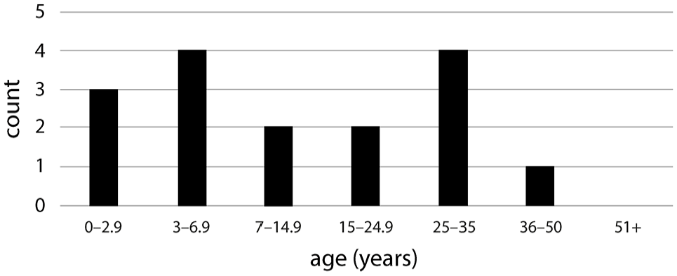
North Desert Cemetery demography for sample analysed in 2023; excludes one individual assessed only as an adult and the isolated skull.
Individuals buried in the North Desert Cemetery seem to be larger than their counterparts in other cemeteries at Amarna. Apart from one adult female, who is exceptionally short (146.9 cm), the small number of adults for whom a stature estimate can be made are all approximately 4 cm taller than average for the other cemeteries at Amarna. 69 The two males exhibit a mean stature of 162.1 cm. The females have widely divergent statures, with the aforementioned short individual lowering the average to 154.3 cm. The other females average 158.1 cm. This difference may simply reflect the small sample analysed to date, but the metric analysis of the subadult sample suggests that it may be a true difference between the North Desert Cemetery individuals and those buried elsewhere. The subadults of the other cemeteries at Amarna exhibit delayed growth and small overall size for age when compared with modern expectations, suggesting high levels of biological stressors inhibited growth and development. 70 All of the subadults in the North Desert Cemetery for whom both a dental age and an assessment of long bone length was possible met, or exceeded, the modern standards for size, suggesting uninhibited growth. Coupled with the higher adult stature, this may suggest a lower level of biological stressors for the individuals buried in the North Desert Cemetery, but this interpretation should be considered extremely preliminary due to small sample sizes.
Paradoxically, this cemetery has a higher frequency of tuberculosis infection than observed at the other cemeteries. Before this year, only one individual in the over 800 individuals analysed displayed the skeletal lesions of tuberculosis. 71 The North Desert Cemetery, on the other hand, has at least one individual exhibiting vertebral lesions clearly consistent with a tuberculosis infection, and at least one other exhibiting vertebral lesions strongly suggesting tuberculosis infection. This may hint at a possible burial location for a close-knit community that shared exposure to pathologic and perhaps environmental conditions that increased the chance of contracting tuberculosis and developing symptoms. It may also support the earlier suggestion of lower overall stress levels, wherein individuals with skeletal lesions of a disease reflect comparative robusticity, surviving long enough to form the lesions. 72
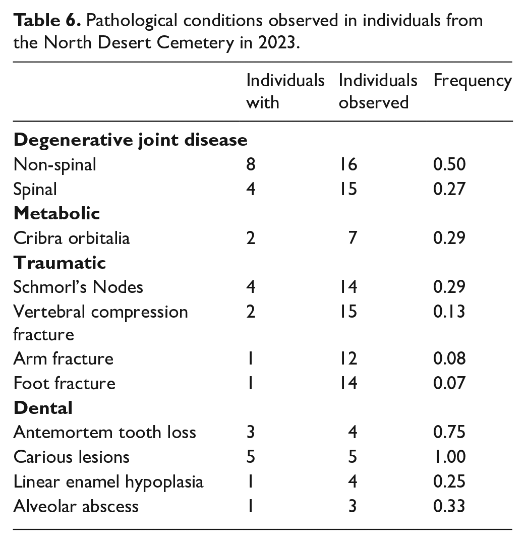
Other indicators of pathology are observed at frequencies generally consistent with other samples from Amarna, but the size of this sample currently makes in-depth analyses of these conditions unwise. The frequency of presence of pathological conditions commonly reported for the Amarna cemeteries is provided in Table 6 for reference. 73
Pathological conditions observed in individuals from the North Desert Cemetery in 2023.
The bioarchaeological analysis of the skeletal remains from the North Desert Cemetery is ongoing. While the small sample analysed to date requires caution in interpretation, this work has begun to provide a picture that is distinct from the previously reported cemeteries, perhaps in ways that suggest slightly greater access to resources and/or less physically taxing workloads. Thus far, the bioarchaeological findings seem to complement the patterns observed in the cemetery archaeology, where greater control of resources may be reflected in the construction of multi-chambered shaft tombs, which are not found at the other pit grave cemeteries. Future work is necessary to clarify these issues.
North Desert Cemetery: Study of the human hair (J. E. M. F. Bos)
The objectives of the hair research at Amarna focus on understanding the technology behind the hairstyles, their various elements, and how these signify social status and ritual practices. This report presents the findings from the 2022 and 2023 seasons, which analysed hair excavated in 2021 and 2022 at the North Desert Cemetery. 74
Research method
The hair remains were catalogued in a database and photographed. Individual hairstyle features were measured where possible, extension types were identified, and braiding techniques described. The hairstyling techniques and types of hairstyles were also documented. The analysis of the hair was primarily conducted macroscopically, with microscopic magnification (60 x to 400 x) used when necessary.
North Desert Cemetery
During the 2021 and 2022 excavation seasons, 23 registration numbers were assigned to hair fragments. These numbers were assigned to fully preserved hairstyles on skulls (one instance, Skull 3041), partially preserved hairstyles (including Ind. 3032/Skull 3020 and Ind. 3008/Skull 3004), and loose hairstyle fragments. Registration numbers may include more than one hair sample if they probably originate from the same individual. Most numbers consist of loose hair fragments or partially preserved hairstyles, which did not allow for the reconstruction of complete hairstyles. For instance, Ind. 3032 displayed only two patches of hair on the lower left back of the skull. Ind. 3008 had a partially preserved braided hairstyle. The overall preservation of hair at the North Desert Cemetery is good, and the hair remains flexible, making it easy to handle and study. The colour of the hair examined during these seasons varied from light brown (in one extension on Skull 3004), to medium brown, and black. Diverse hair colours and textures were observed within the braids and extensions. Unless it is attributable to taphonomic or preservation factors, this colour variation likely endowed the hairstyles with a multi-coloured appearance when they were intact.
The only fully preserved hairstyle was that of Skull 3041. This individual was wearing a bob-length (15–20 cm long), loose-hanging hairstyle with hair following the outline of the skull and directed towards the back of the head. No part over the top of the head was visible. Nonetheless, the hair was deliberately parted at the forehead and the two strands on either side of the forehead had been tucked away behind each ear. Although the soft tissue and ears were not preserved, the hair was stiffened to such an extent that the tuck was still visible. The hair colour was greying, medium brown hair.
Braids of different widths were encountered (2–21 mm, in nineteen registered braids, all from Ind. 3008), as well as small patches of loose hair fragments (20 registered samples) and hair extensions (66 registered extensions). In eleven cases, the braids showed more than one level of extension. In one instance, the braid (a complete example, from Ind. 3008/Skull 3004, with scalp hair and clear braid endings) contained as many as thirteen extensions, set at eight different heights (levels) of the hairstyle. In this case, four long and twisted (S-spun) hair samples were woven into an extended braid that was preserved for 45 cm, the complete length of the hairstyle.
All observed braiding techniques were fairly simple, displaying three-strand braids. The original length of the braids could be determined only for Skull 3004/Ind. 3008. The braids here ranged from approximately 35 to 46 cm, with a width of around 20 mm. This length and style are generally consistent with other braided hairstyles from the North Desert Cemetery and the other Amarna cemeteries, particularly the North Cliffs Cemetery, and to a lesser extent the South Tombs Cemetery. 75 Depending on the individual’s height, these braids would have reached halfway down the upper torso, between the shoulder blades. Interestingly, the first level of extensions was placed very close to the scalp, suggesting that the wearer kept their hair short and relied on extensions to achieve the desired length. This is further supported by the numerous extensions used in the braids, which increased both the volume and length of the hairstyle. Additional extensions were incorporated at five to eight different levels, varying based on the extension’s width and the intended thickness and length of the braids. The elaborate long braided hairstyles culminated in pipe-curled loops at the ends, created using separate extensions that were tied and braided into the lower parts of the hair and styled post-braiding.
Although the hair fragments were often very incomplete, the preservation of the extensions was good, and the methods by which they were attached and produced could still be discerned. The manner in which this was done is consistent with results published in previous seasons. To sum up, the excavations in 2021 and 2022 at the North Desert Cemetery yielded one intact hairstyle and two fragmentary preserved hairstyles. Other loose fragments studied show extensions, detached braids, and loose hair without visible styling features. The hair assemblage shows strong similarities with hair from the North Cliffs and to a lesser extent the South Tombs Cemeteries, in terms of hairstyles and hairstyling techniques. 76 Although the South Tombs Cemetery assemblage was in a poorer state of preservation, it did yield a higher diversity of hairstyles, but this may reflect the larger number of graves excavated there, rather than socio-cultural differences. The documentation of the hair from the North Desert Cemetery was completed this season.
Other Projects
During the autumn 2023 season, the study of the Long Temple at the Great Aten Temple continued, under the direction of the late Prof. Barry Kemp. 77 The team completed the cleaning and re-planning of the Fourth Court of the Long Temple, and partly reconstructed in stone several offering-tables and lengths of wall in areas of the temple previously cleared, including two large offering-tables in Courts Five and Six. Pamela Rose finished recording pottery from the North Desert Cemetery, with preliminary findings consistent with those reported on previously from this site. 78 Amandine Mérat continued her study of the textiles from the Amarna cemeteries, checking further details of samples from the South Tombs Cemetery in advance of final publication. Conservators Lucy Skinner and Julie Dawson spent a short period of time on-site checking the condition of coffins excavated at the South Tombs Cemetery. Jean-Pierre Pätznick continued a study of stamp- and seal-impressions. Marsha Hill checked entries for her now-published monograph on Amarna statuary with Kristin Thompson. 79 Chris Stimpson studied bird remains and small vertebrates from the environs of the official residence of Panehsy. 80 Anna Hodgkinson’s study of site M50.14–16 continued, with the analysis of zooarchaeological samples by Salima Ikram, 81 and glass-making experiments by Anna Hodgkinson and Miriam Bertram. 82 Catherina Kalmykova and Sue Kelly updated the carved stone and small-finds databases for work at the Great Aten Temple, and Juan Friedrich, with the assistance of Martha Torres and Silvina Buccafusca, illustrated carved stone fragments from the Temple. 83
Footnotes
Acknowledgements
The Amarna Project is grateful for the support of the Egyptian Ministry of Tourism and Antiquities (MoTA), particularly from the staff of the Minia and Mallawi MoTA offices. We thank Mr Gamal Abu Bakr (general manager for Middle Egypt), Mr Hasan Taher (general manager for South Minia), Mr Fathy Awad (manager of the Mallawi sector) and Mr Hamada Kellawy (chief inspector of Tell el-Amarna). Inspectors for the work at the Great Aten Temple were Mr Rami Ishak Loui and Mr Roman Talaat Adli, and for the housing survey Ms Mona Abdeldaiem Nan and Mr Salama Nagi Mohamed. Mr Mustafa Khallaf served as Magazine Inspector. Mr Fathi Awad and Mr Hamada Kellawy were instrumental in facilitating the project to build the boundary wall at El-Till, including through community consultation. The construction was contracted to Eng. Amr Tarek Sanadiki and his team, and we are most grateful for their professional work, and to Eng. Tarek Sanadiki (†) for his preliminary work on this project. Mr Mazhar Khalifa supervised the construction work on behalf of the MoTA. For their assistance in organising and running the Community Open Day, we are especially grateful again to Mr Fathi Awad and Mr Hamada Kellawy, and to Mr Joseph Qased Fanus and the Visitor Centre staff. Thanks are also due to the finance team at Monash University, particularly Harry Dhaliwal, for their assistance with grant management.
Funding
The Great Aten Temple excavations received funding from the Amarna Trust, with additional contributions for the work at the eastern end of the temple from the Amarna Research Foundation and the Thames Valley Ancient Egypt Society. The project Akhenaten’s City: Protecting Amarna’s Urban Heritage is funded by the American Research Center in Egypt’s Antiquities Endowment Fund (USAID), with additional support from the School of Philosophical, Historical and International Studies, Monash University. Tutankhamun the Boy: Growing Up in Ancient Egypt was funded by the Esmée Fairbairn Collections Fund, administered by the Museums Association, and the Friends of the Petrie Museum. The project Preservation Through Education: Protecting Ancient Settlements Through Outreach at Amarna, Egypt is funded by the Archaeological Institute of America. The Amarna Trust provided a supplementary grant for the housing survey. Work on materials from the cemeteries was funded by the Institute for Bioarchaeology and the School of Anthropology, Political Science, and Sociology at Southern Illinois University.
1.
British Mission to Tell el-Amarna, McDonald Institute for Archaeological Research, University of Cambridge, directed by Prof. Barry Kemp (†).
3.
9.
10.
Possibly from a scene showing the king and queen worshipping Aten, similar to that on a balustrade fragment from the Great Palace: Egyptian Museum Cairo, inv. JT 30/10/26/12; Freed, et al. 1999: 152, fig. 113, 226, cat. 72.
11.
Balestra in Stevens, et al. 2023: 90–99; 2021.
12.
Balestra in Stevens, et al. 2023: 94.
15.
Valentina Gasperini, personal communication, 11.2023.
16.
Marc Gabolde, personal communication, 01.2024.
19.
Davies 1903: pls XI, XXXIII; Davies 1905a: pl. XIX; ![]() : pl. XXX.
: pl. XXX.
21.
For further information, see Gasperini and Rose, in Kemp, et al. 2023: 54–56.
25.
For further information, see Bertram in Kemp, et al. 2023: 49–53.
28.
Boonstra in Kemp, et al. 2022: 19–20.
29.
Boonstra in Kemp, et al. 2023: 69–75.
32.
However, the present study has amended the definition of a tile to be any shape provided that it bears multiple elements of an image or scene.
34.
Lucas 1962: 161–167; ![]() : 199–214.
: 199–214.
38.
E.g. Kemp and Stevens 2010a; ![]() .
.
39.
These issues are presented in detail in a recent Site Management Report: Tully, et al. 2020.
48.
Which may have continued to the end of the New Kingdom or later: Kemp 1995: 446–448; ![]() .
.
50.
Sartini 2015; there is a possibility that they continued into the early 20 Dynasty: Sartini 2019. The scarab is more difficult to date. Unprovenanced scarabs showing obelisks being venerated are usually dated to the 18 Dynasty–Third Intermediate Period. Provenanced examples include those from graves at Gurob dated by the excavators to the 19 Dynasty: Brunton and Engelbach 1927: pl. XLI, nos 70, 72 (scarabs); and from Tell el-Farah South and Ekron in the Levant, dated to the 19 Dynasty and Ramesside Period: Keel 2010a: 552–553, no. 73 (seal impressions); ![]() : 160–161, 172–173, nos 305, 333 (scarabs). I thank Stephanie Boonstra and Tracy Lakin for bringing these to my attention.
: 160–161, 172–173, nos 305, 333 (scarabs). I thank Stephanie Boonstra and Tracy Lakin for bringing these to my attention.
52.
Kemp and Garfi 1980: plans 7, 8; EES.TA.NEG.24–25.064.
54.
Griffith 1924: 303; ![]() : 33.
: 33.
56.
57.
For which, see also Kemp and Stevens 2010a: 388–397; and ![]() .
.
58.
Tully, et al. 2020: 18, 29, 36.
59.
Central to which has been the work of Alice Salvador (design and illustration) and Ferida Jawad and Adel Abdel Moneim (translation).
60.
This took place at the Petrie Museum of Egyptian and Sudanese Archaeology, UCL, and the Amarna Visitor Centre from May 2022 to November 2023.
61.
Led by Gretchen Dabbs at Southern Illinois University, Carbondale.
62.
For which, see Tully in Stevens, et al. 2023.
63.
Kador, et al. 2018: 160.
64.
Resources that have been provided in part through the above-listed projects, and in part through a Newton-Mosharafa Institutional Links project (2017–2019; PIs Kate Spence and Yasmin El-Shazly).
65.
For which, see Tully, et al. 2020.
67.
See Dabbs in Stevens, et al. 2020.
68.
69.
Statures estimated using formulae published in Raxter, et al. 2008: 150; statures for the other Amarna cemeteries are available in Dabbs in Stevens, et al. 2020: 9.
70.
72.
See Wood, et al. 1992 for further discussion of the Osteological Paradox.
74.
For other hair samples from this cemetery, see Bos in Stevens, et al. 2020; Bos in Stevens, et al. 2022.
75.
Bos in Stevens, et al. 2020: 12.
77.
For further information on the work, see Kemp, et al. 2023.
78.
For the latter, see Rose in Stevens 2023.
80.
Stimpson in Kemp, et al. 2023: 58–60.
81.
Ikram in Kemp, et al. 2023: 61–62.
82.
Hodgkinson and Bertram in Kemp, et al. 2023: 62–66.
83.
Friedrich in Kemp, et al. 2023: 76–77.