
Abstract
Roman activity in Egypt’s Eastern Desert fluctuated significantly, ranging from intense exploitation of its resources and desert routes that facilitated Indo-Mediterranean trade, to the Roman Empire’s near total abandonment of the region. In those areas crucial to the Roman state – stone quarries, Red Sea ports, desert road stations and mining settlements – a nadir in occupation occurs near the mid-third century CE. But archaeological evidence indicates that significant reductions in activity occurred between the late second and early third centuries CE – i.e., in the Antonine and Severan Periods. The downturn was probably a result of distant geopolitical engagements, outbreaks of disease and/or shifting patterns of trade, which led to the Empire’s neglect of and gradual withdrawal from the area. This article reviews the archaeology of the Eastern Desert and considers the reason(s) this once-important region fell into decline.

Introduction
Activity in the Eastern Desert of Egypt ebbed and flowed in the Roman Period, ranging from high activity across much of the inhabited region to none at all in key locations. In those areas crucial to the Roman state – e.g., the Red Sea ports of Berenike and Myos Hormos, the quarries at Mons Claudianus and Porphyrites, mining areas, and principal land routes between the Red Sea and the Nile – a nadir in activity occurs around the mid-third century CE. Archaeological evidence reveals, however, that many important sites became far less busy in the latter half of the second century CE, with wider site abandonment beginning in the early third century.
The Eastern Desert and the Red Sea were vital to Rome’s acquisition of luxuries – such as spices, textiles, precious stones, and jewels – as well as some common eastern goods, acting as a gateway to trade with southern Arabia and South Asia. This gateway became less dynamic starting in the Antonine Period (138–193 CE) and nearly closed soon after the Severan Period (193–235 CE). From a broader perspective, the Roman Empire faced a flurry of difficulties that had been accumulating since a late second century CE pandemic struck in Marcus Aurelius’ reign (161–180 CE). Then, towards the mid-third century CE, the Empire felt socio-political, geo-political, financial, and cultural issues, as well as another pandemic, strain its stability; these issues together termed the ‘Crisis of the Third Century’. Whether or not events around the mid-third century CE did coalesce into a crisis that affected activity in the Eastern Desert becomes immaterial with thorough investigation of the archaeological evidence. The archaeology suggests that something disrupted trade patterns and stone and mineral extraction in the region well before the mid-third century. 1 The momentous imperial events of the late second century – the Antonine Plague (traditionally dated to between 165–180s CE) and Rome’s wars with the Parthian Empire in western Asia (161–166 CE) and the Marcommani in central Europe (166–180 CE) – most likely had something to do with the transition.
This paper reviews the archaeological evidence from the Eastern Desert, followed by a discussion on the reason(s) for the Roman state’s neglect of, and eventual withdrawal from, this once-important region.
Egypt’s Eastern Desert under Rome
The infrastructure of Egypt’s Eastern Desert substantially improved following Rome’s annexation of Egypt in 30 BCE (fig. 1). However, while most sites were founded in and have evidence from the first century CE or later, a few have Pharaonic era evidence (e.g., Koptos, Mersa Gawasis, and al-Kanaïs), and a number have Ptolemaic evidence. 2 Seeking gold from Eastern Desert mines and war elephants from further south, Ptolemaic kings built phrouria (forts) and hydreumata (wells) east of the Nile River – to support travel through the harsh desert – and ports on the Red Sea coast. 3 The port at Berenike was originally installed to receive elephants, and the ports at Mersa Nakari (probably ancient Nechesia) and Myos Hormos may have served a similar function.
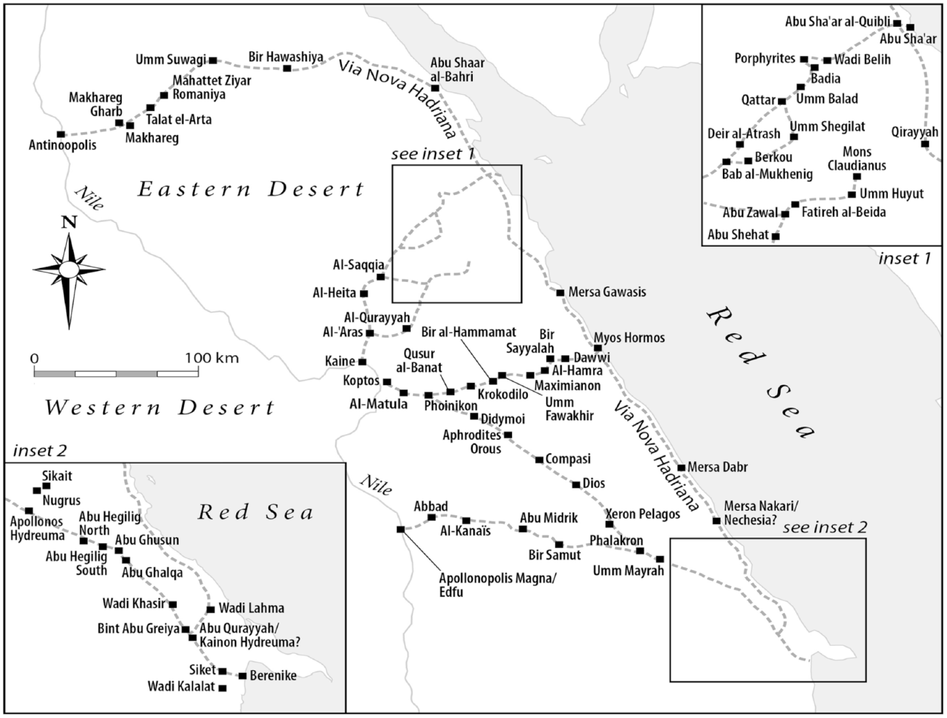
Ancient sites and roads in the Eastern Desert (map: author).
While exchange between Ptolemaic Egypt and Indian Ocean societies did take place, the Roman Empire significantly expanded commercial contacts early on in its control of Egypt. Writing in the late first century CE, Strabo claims: ‘around 120 ships sail from Myos Hormos to India, whereas, under the Ptolemies, very few would venture to take the voyage’. 4 The first century CE Graeco-Roman periplus, the Periplus Maris Erythraei, opens with: ‘Of the designated harbours of the Erythraean sea and the ports of trade on it, first comes Egypt’s port of Myos Hormos and, beyond it, after a sail of 1800 stades to the right, Berenicê.’ 5 That the unknown author begins his work here underscores the importance of the ports to eastern trade in Early Roman Egypt (30 BCE–150 CE). 6 Land routes guided Asian goods from the Red Sea ports to Nile emporia, from which imports were sent north along the Nile to Alexandria and the Mediterranean Sea, and vice versa for exports. With Egypt acting as the gateway, Indo-Mediterranean trade became a substantial source of tax revenue for the Roman state. 7
Around the same time, the quarries of the Eastern Desert – especially Mons Claudianus and Porphyrites – became important to Rome’s construction programmes in the capital and the provinces. Quarrying in the Eastern Desert for imperial building projects was rare before Nero (54–68 CE) and the Flavians (69–96 CE), whereas afterwards, particularly in the Trajanic (98–117 CE) and Hadrianic (117–138 CE) periods, imperial stone quarrying at Mons Claudianus and Porphyrites and transport to the Mediterranean increased exponentially. 8
Rising activity at the Eastern Desert quarries and the Red Sea ports led to the establishment of a network of praesidia (forts) and hydreumata that dwarfed the network of the Ptolemies. Common Ptolemaic routes between the quarries and the Nile, and the Red Sea and the Nile, became full-fledged (unpaved) roads in the Roman Period, due in large part to the Eastern Desert praesidia and hydreumata system that made travel in this climatically-hazardous and previously unguarded region far safer. 9 For the Red Sea–Nile routes, the Romans established praesidia and hydreumata on the route connecting Myos Hormos with Koptos on the Nile, along the Berenike–Koptos road, and repurposed stations on the road between Berenike and the Nile emporium Apollonopolis Magna. The latter’s main phases of construction and activity took place in the Ptolemaic Period with only minor occupation in the Roman Period when the road to Koptos became the principal thoroughfare linking Berenike with the Nile (fig. 1). 10 Additionally, Hadrian commissioned construction of the Via Nova Hadriana (mid-130s CE) which was associated with several Eastern Desert sites – including hydreumata, praesidia, and mining and quarrying settlements – running from Antinoopolis to and along the Red Sea coast all the way to Berenike. 11
Roads servicing travel from the major quarries to the Nile had a number of installations that were built in the Early Roman Period, and some paths overlapped. Trekking from the quarries of Mons Claudianus to the Nile emporium Kaine (modern Qena), a traveller could take two tracks: a direct route leading to Kaine (the Mons Claudianus–Nile road), or another that converged with the Porphyrites–Nile route. 12 The road connecting Porphyrites with Kaine had ten associated stops and two additional stops northwest of the quarries. 13 Recent work revealed there was another, earlier track of the Porphyrites–Nile road (the ‘Ghozza path’) that led to the Roman praesidum at Berkou/Ghozza (fig. 1), but the route fell out of use along with Berkou in the late first/early second century CE. 14 This convoluted road network may seem unnecesary, but it served a strategic purpose: the Mons Claudianus-Porphyrites route convergence suggests heavy traffic from the quarries in the Early Roman Period, and two possible routes from Mons Claudianus would have alleviated congestion at road stops en route to Kaine. 15 The road system demonstrates high activity early on in Rome’s occupation of Egypt. 16
At the quarries, the ports, and the routes connecting them to the Nile, material remains demonstrate declining activity in the latter half of the second century CE. By the early third century, further reductions in activity (and in some cases abandonment) are observed at key Eastern Desert sites, including Berenike, Myos Hormos, Mons Claudianus, and most quarry settlements of Porphyrites. From decline at the major locales came decline along their supporting roads, as numerous road stops – praesidia, hydreumata, and associated settlements – exhibit late second/third century CE reductions in activity. The following section highlights this transition through a review of the archaeology.
Archaeological Evidence
Archaeological excursions to the Eastern Desert began as early as the late eighteenth century. 17 A number of surveys were conducted in the nineteenth century, and further surveys were administered in the early–mid-twentieth century, but archaeological campaigns in the Eastern Desert gained significant traction between the late twentieth century and our current century. 18 It is analysis from the latter which this article mostly draws upon. Since all Roman sites in the Eastern Desert could not be examined for this study, locations crucial to the life of the region, such as the major quarries, ports and mines, as well as the roads, forts and wells that served them, were given precedence. This region of Roman Egypt can be divided into three chronological periods based on archaeological evidence demonstrating distinct phases of activity: the Early Roman (30 BCE–150 CE), Middle Roman (150 CE–298 CE) and Late Roman (298–641 CE) periods. Most sites discussed below were dynamic preceding the period under consideration, and thus exhibit the stark contrast in activity between the Early and Middle Roman periods. I start with archaeological evidence from the northernmost site of significance, Porphyrites, and work southward through the Eastern Desert.
Porphyrites
Approximately 370 km as the crow flies south from Cairo, 40 km west of the Red Sea Coast, and 135 km from Kaine on the Nile, the quarries and villages that make up Porphyrites lie in harsh terrain near the western edge of the Red Sea mountains. 19 There is no discernible activity at the site prior to the Roman Period, but the Empire began exploiting the quarries very soon after its arrival to Egypt. The porphyry stone, for which the site is well-known, is distinctive in appearance (‘imperial’ purple) and durability, leading to extensive quarrying in the area throughout much of the Roman age.
The earliest evidence at Porphyrites is Tiberian – dedicatory inscriptions (dated to 18 and 29 CE) in the Bradford and Foot Villages (fig. 2). 20 The archaeology reveals that these villages had short histories, as material evidence indicates both were abandoned in the first half of the first century CE. 21 Remains from the North-West Village – pottery, one coin, and two frog-style lamps – demonstrates a main period of occupation from the mid-first to the mid-second centuries CE, while far lower quantities of late Antonine and Severan pottery suggest waning activity. 22 No firmly dated post-Severan evidence was found.
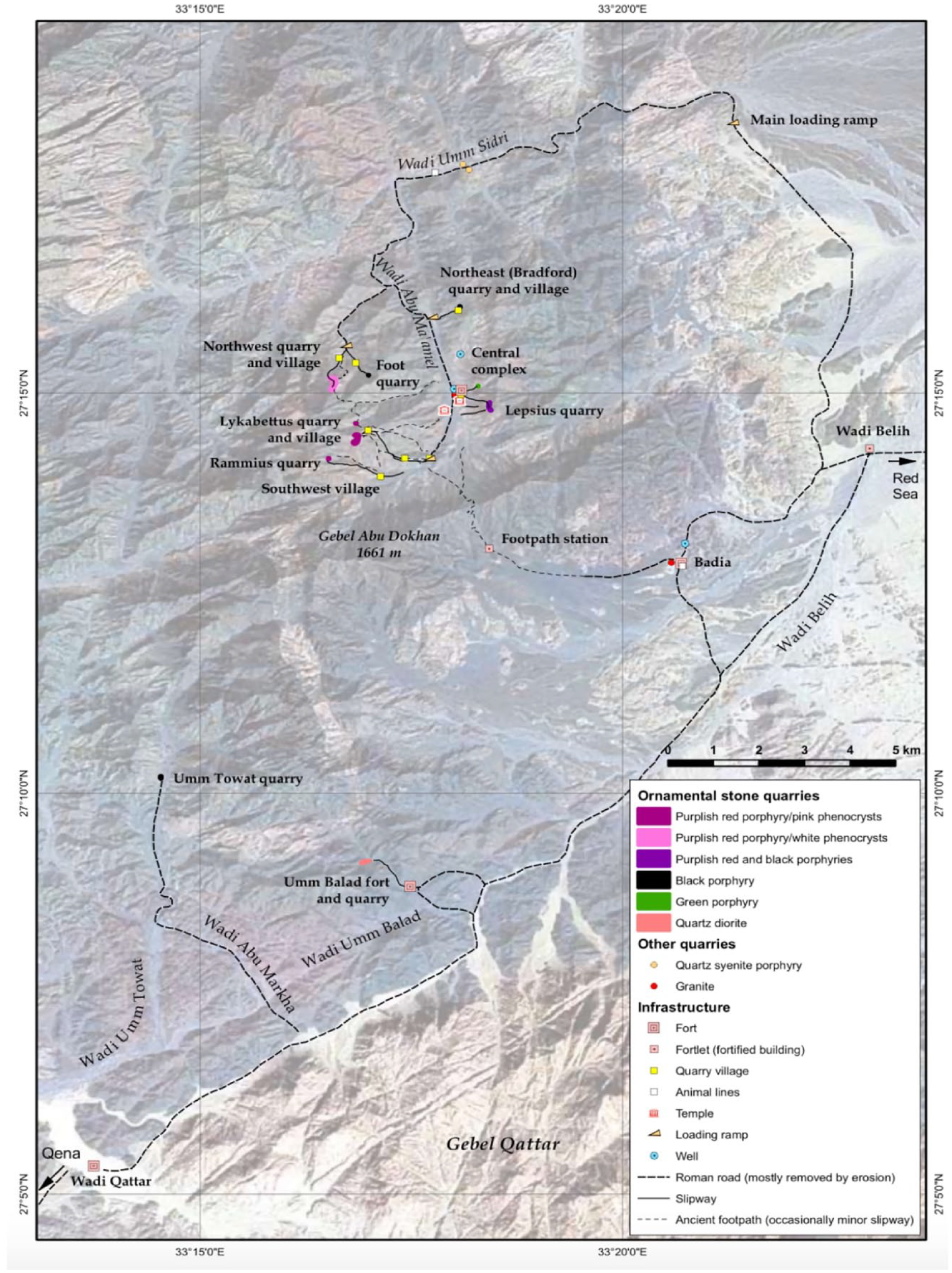
The quarries, structures, and villages associated with Porphyrites. (map: Harrell and Stormyr 2009: fig. 28).
A fort and a number of associated structures – water-supply installations, slipways and cairns – were installed in Wadi Abu Ma’amel in the late first/early second century CE, acting as the administrative centre of Porphyrites. 23 Material evidence from the fort’s rubbish dumps is concentrated to the late second and early third centuries. This is noteworthy since, as we will see, it is the only valuable location in the region pointing to higher activity in the late second/early third century CE than in the late first/early second century CE. However, activity declined drastically towards the second quarter of the third century, as no artefacts – coins, ceramics, or documentary evidence – date securely to the second half of the century. 24
At the Lepsius Quarries, a central quarry area immediately adjacent to the fort, ceramics ‘gave a date no later than the mid-second century’, aside from a small collection of late Roman pottery found at huts in the Lepsius area. 25 Pottery from the South-West Village reveals that it was first settled by the mid-first century CE, ‘grew to its maximum extent’ in the later first to mid-second century, and was probably abandoned in the latter half of the century. 26 At Lykabettus Village, almost all evidence is Late Roman. The eight coins uncovered are from the fourth century, and most ceramics date to the fourth and fifth centuries CE, apart from a very small amount of Early Roman sherds which ceramicist Roberta Tomber says, ‘is not indicative of early occupation’. 27 No evidence from the third century CE was found.
The archaeological evidence shows that quarry operations at Porphyrites were vigorous in the Early Roman Period, while just one area (the fort complex in Wadi Abu Ma’amel) remained active between the late second and early third centuries CE, with the rest showing minimal or no activity between the mid-second century CE and the Late Roman Period. That Maxfield and Peacock think evidence from the fort ‘suggests the site was a secondary feature of the Mons Porphyrites landscape’ may explain the disparity between material evidence at the fort and the quarry settlements; particularly conspicuous in this regard is the lack of Middle Roman Period evidence from Lepsius, a principal quarry area next to the fort. 28 Also revealing is the weakly attested use of porphyry in the later Antonine Period. 29 It could be that largescale quarrying reduced considerably in the Middle Roman Period but Roman officials continued occupying Porphyrites’ fort/administrative centre as a protective measure. By the mid-third century CE, the Roman state had pulled out of the quarries, a withdrawal that lasted until at least the last decade of the century. Imperial quarrying began again in the fourth century CE at Lykabettus Village and its associated quarries, but the rest of Porphyrites remained largely unoccupied.
The Porphyrites–Nile road and its stops
Trekking 135 km across harsh desert terrain with huge masses of igneous rock would not have been feasible without watering stations, which was the principal purpose of the Porphyrites–Nile road stops (fig. 1). In 1991, Sidebotham, Zitterkopf, and Riley thoroughly surveyed the road and its associated stops and towers. 30 Surface remains do not provide a full picture of activity at the stations, but they give a general idea of occupation, particularly when stations were abandoned. Most road stops were established in the first century CE, contemporary with the beginning of quarry operations at Porphyrites. All have water management and/or water storage installations, some far more extensive than others, equipped to hydrate travellers and their draught animals. 31 West of Porphyrites, the road continues to the Red Sea; however, this section only picked up significant traffic following the installation of the fort at Abu Sha’ar on the Red Sea coast in the early fourth century CE.
The evidence suggests that, like Porphyrites, stations on the Porphryites–Nile road saw little activity in the third century CE, with a few showing none at all. The majority of the ceramics date to the first and second century CE, while some date to the Late Roman Period (fourth–sixth century CE).
Sites with small amounts of ceramics that may date to the third century CE are: (1)
Road stops where no evidence dating to the third century was found are:
Mons Claudianus
Approximately 420 km south of Cairo, 45 km from the Red Sea, and just over 100 km to Kaine on the Nile, the quarries and castellum (fort/central complex) at Mons Claudianus are situated in the Red Sea–Nile watershed, at the centre of the Red Sea mountains (figs 1 and 3). 38 Excavation of the complex uncovered an abundance of evidence, comprised of ceramic, inscriptional, numismatic, and documentary evidence that includes over 10,000 ostraca – the largest collection of ostraca ever to be found at one site. 39
Mons Claudianus seems to have been strictly a Roman enterprise. The quarries were probably in use by the mid-first century CE, but operations ramped up in the Flavian and Trajanic Periods, necessitating sizeable support facilities – i.e., the fort complex (fig. 4). 40 Subsequent to the fort’s initial phase of construction, a large extension was added to its northern section (‘the annexe’) – probably in the mid-second century CE – that included around 25 rooms and a throughway, reshaping the fort into a square. 41 Maxfield and Peacock established a terminus post quem of 144/145 CE for the start of construction on the extant granary/animal lines west of the main fort (fig. 4), based on documents found in rubbish deposits beneath it. 42 The additions indicate that the quarries were being heavily exploited at least until the mid-second century CE. There is also substantial inscriptional and quarry-mark evidence from the Trajanic-Hadrianic Period, as well as numismatic evidence from the first and second centuries CE. 43 Finally, external evidence demonstrates extensive quarrying at Mons Claudianus in the late first century and the first half of the second century CE: Claudianus granodiorite was used in five Flavian building projects, four Trajanic projects, and six Hadrianic projects (including the Templum Divi Traiani, the Temple of Venus and Roma – finished in Antoninus Pius’ reign – and the Pantheon). 44
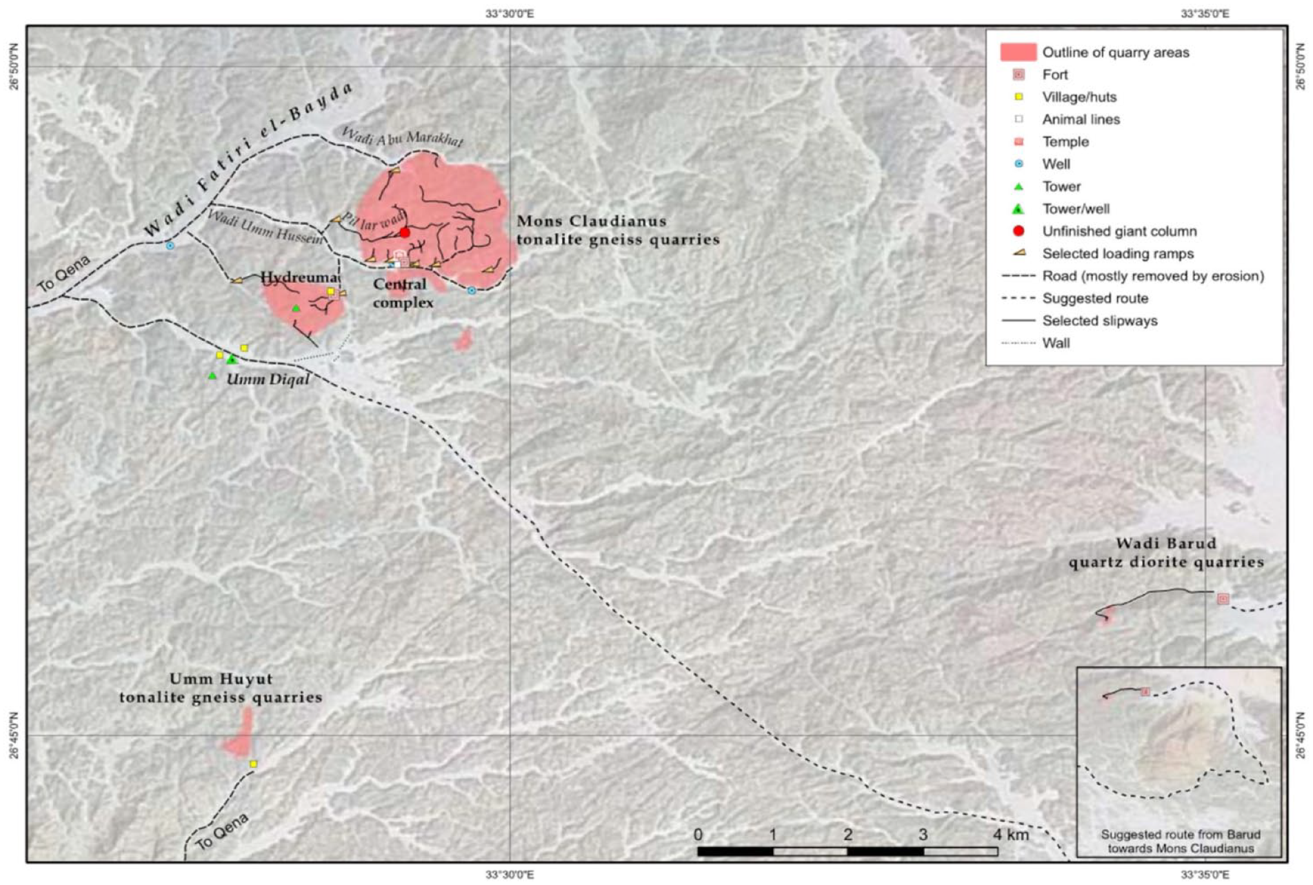
The quarries and structures of Mons Claudianus (map: Harrell and Storemyr 2009: fig. 26).
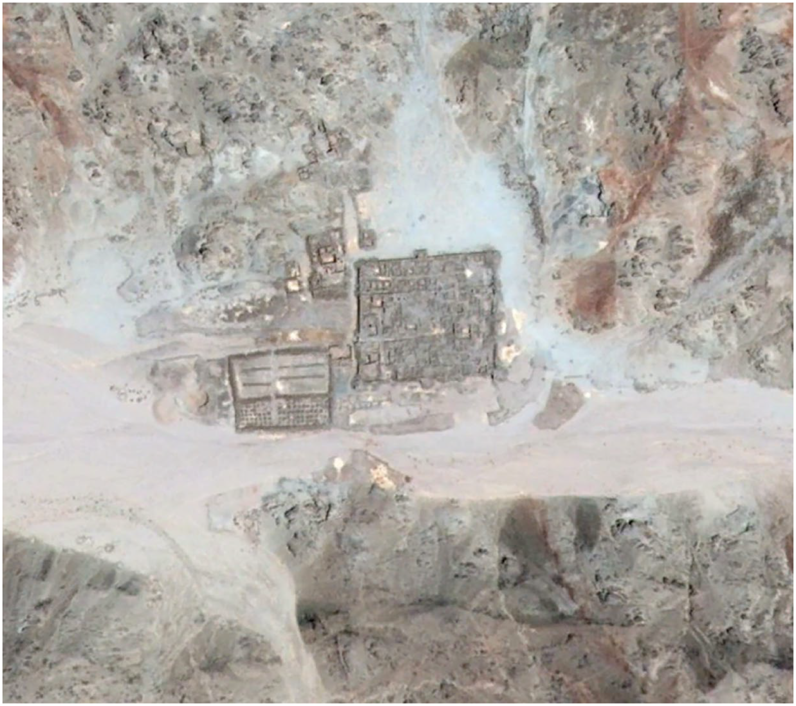
Satellite image of the Mons Claudianus fort complex. Note the granary with animal lines west of the fort (image: Google Earth Pro).
Activity at the quarries declined in the Antonine Period, after which, ‘evidence for the exploitation of the Claudianus complex becomes distinctly sporadic’ for the remainder of its history. 45 The last firmly dated evidence until the very late Antonine Period is an ostracon from 154 CE, suggesting a near 30 year silence at the quarries. While there is evidence from Commodus’ reign, it is minimal – four ostraca dating between 180/181 and 189 CE – and the excavating archaeologists say it is ‘unsupported by any other documentation and nor can it be tied in with any known building programme.’ The near discontinuation of ostraca speaks plainly about a site holding 10,000 pieces in total, the overwhelming majority of which predate 154 CE. Furthermore, numismatic evidence ceases following Pius’ reign (138–161 CE) until the late third century CE, there is no external evidence for the use of Mons Claudianus granodiorite between Pius and the Baths of Caracalla (dedicated in 216 CE), and the major external rubbish dumps stopped receiving deposits after the 150s CE, contrasting with the dumps at Porphyrites’ fort. 46 Plummeting activity comes at a curious time: the fort’s extensions – the annexe and granary/animal lines – were completed just years before the last datable ostracon (154 CE) until those from Commodus’ reign.
In the third century CE, activity is patchy. We have minimal evidence from the Severan Period: two ostraca from the reign of Septimius Severus (193–211 CE); granodiorite used in the construction of the Baths of Caracalla (211/212–216/217 CE); a papyrus dating to 214–215 CE; quarry marks possibly from Macrinus’ reign (217–218 CE); Claudianus stone used in additions to the Baths of Caracalla in Elagabalus’ (218–222 CE) and Severus Alexander’s reign (222–235 CE) respectively; and an ostracon dating to the latter’s reign. 47 No evidence dating to the period between the reigns of Severus Alexander (235 CE) and Aurelian (270 CE) was found. The late third century material is two coins – one of Aurelian (270–275 CE) and another of Probus (276–282 CE) – and the archaeologists note that the coins were found near one another, suggesting a passer-by probably dropped them, as the complex was in an ‘advanced state of decay’ at that point. 48
Mons Claudianus–Nile route(s)
Stations along the Mons Claudianus–Nile road (fig. 1) have not been systematically excavated, but surface remains give an idea of when stations were abandoned.
Six kilometres south of Mons Claudianus is Umm Huyut, a small quarry settlement proximally associated with the road. Pottery collected at Umm Huyut firmly indicates activity in the first and second centuries CE, but not later, suggesting it fell out of use in the late second or early third century CE. 49 Fatireh al-Beida – the first road stop travelling southwest – only produced pottery dating to the Early Roman Period (30 BCE–150 CE). 50 Ceramics at Abu Zawal indicate activity at the praesidium from the late first century CE to the first quarter of the third century CE. 51 Based on surface remains collected at Abu Shehat/Talat al-Zarqa, a site about which little is known, the surveying archaeologists propose occupation from the early second century CE, but it is unclear if the station functioned into the third century. 52 Sidebotham proposed a chronology for the next station at al-Qurayyah, saying pottery demonstrates activity between ‘likely 1st–3rd/4th century CE’. 53 Seemingly, the third/fourth century CE date is from remains of Africano Grande amphorae – which can date anywhere from the third/fourth to the sixth century CE – and thus does not confirm occupation in the third century.
Similar to the Porphyrites and Mons Claudianus quarries, and the Porphyrites–Nile road, evidence from stops along the Mons Claudianus–Nile road demonstrates that the route’s main functional period centred on the first and second centuries CE. There is little indication that the road was used after the Severan Period.
Myos Hormos
Located near modern Quseir al-Qadim, Myos Hormos was a trading port in the northern Red Sea that served as a maritime shipping gateway for Roman exports and South Asian and Arabian imports. 54 Eastern merchant ships would transfer their goods at Myos Hormos and imports were then hauled through the Eastern Desert along the Myos Hormos–Koptos road for shipment up the Nile.
Substantial ceramic assemblages dating to the first century CE were uncovered during archaeological campaigns by the University of Southampton between 1999–2003, confirming Strabo’s claim that the port was bustling then. 55 Younger assemblages indicate activity probably remained high in the first half of the second century CE, but waned later in the century, with less areas showing signs of occupation, followed by abandonment in the third century CE. 56 Overall, the site produced little evidence from the third century CE. The latest Roman evidence is a house built near the harbour in the first half of the third century CE; but it was abandoned by the middle of the century and comprises the only activity at the port in the second quarter of the century. 57 From that point, Myos Hormos remained completely unoccupied until the Islamic Period.
Archaeological and sedimentological investigations of Myos Hormos revealed that the port faced problematic siltation in the first and second centuries CE. 58 The Romans appear to have counteracted the siltation by dredging the harbour (the removal of sediment and debris for unobstructed seafaring), as suggested by sedimentological analyses, and by building sea walls and makeshift jetties made of amphorae, all of which probably helped keep the port a viable docking location. 59
Some propose unmanageable siltation was the reason for the abandonment of Myos Hormos in the third century CE. 60 However, Jean-Pierre Brun noted that by at least the second century CE, the Romans employed systematic dredging to counter siltation in the Mediterranean, citing evidence from the Roman harbours at Marseille and Naples. 61 Since the Roman military and/or elites were regularly dredging harbours in the Mediterranean – and because sedimentological evidence at Myos Hormos itself point to the harbour having been dredged in the second century CE, with it fully silting to disablement only after being abandoned by the Romans – it suggests that siltation was not the sole reason for Myos Hormos’ decline and eventual abandonment. 62
The Myos Hormos–Nile road
The road conveying merchants between Myos Hormos and the Nile produced evidence showing a similar chronology to the port it supported (fig. 1). The road had ten stations and over 60 signal/watch towers. 63 Some stations have been excavated; others only surveyed. At all but one station there is a clear break in activity around the turn of the third century CE. Of the ten stops on the Myos Hormos–Nile road, two had forts constructed in the first century CE (Maximianon/Al-Zerqah and Krokodilô), one fort was built in the early second century CE (Bir Sayyalah), four were founded in the latter half of the second century CE (Dawwi/al-Iteima, al-Hamra, al-Hammamat, and Qasar al-Banat), and the remaining three stations (Umm Fawakhir, Phoinikon/Laqeita and Matula) probably had forts but none are extant. Three stations fell out of use by the mid-second century CE, and, except for Matula, a lack of material evidence from the rest points to abandonment in the late second or early third centuries CE; notable given some stations had been founded just decades prior. 64 Also remarkable, the chain of signal/watch towers – the construction of which probably began in second half of the second century CE and was overseen by a high-ranking Roman official (a centurion) – appears to have never been finished and, like Myos Hormos’ road stations, was abandoned by the early third century CE at the latest. 65
The Berenike–Nile road
There are a multitude of sites associated with the Berenike–Koptos road (25 in total), a key commercial thoroughfare in the Early Roman Period that supported traffic between the port at Berenike and Koptos on the Nile. Some sites were founded by the Ptolemies, but the majority were Roman installations. Table 1 lists all sites linked with the Berenike–Koptos route, showing that many had fallen out of use in the Middle Roman Period. In bold are places that may have seen imperial activity in the period under consideration. I home in on those here.
Installations associated with the Berenike–Koptos road listed in order from Koptos. In bold are sites showing activity in at least part of the third century CE (data: Sidebotham, Gates-Foster, and Rivard 2019; <https://desertnetworks.huma-num.fr> (accessed 20.07.2021)).
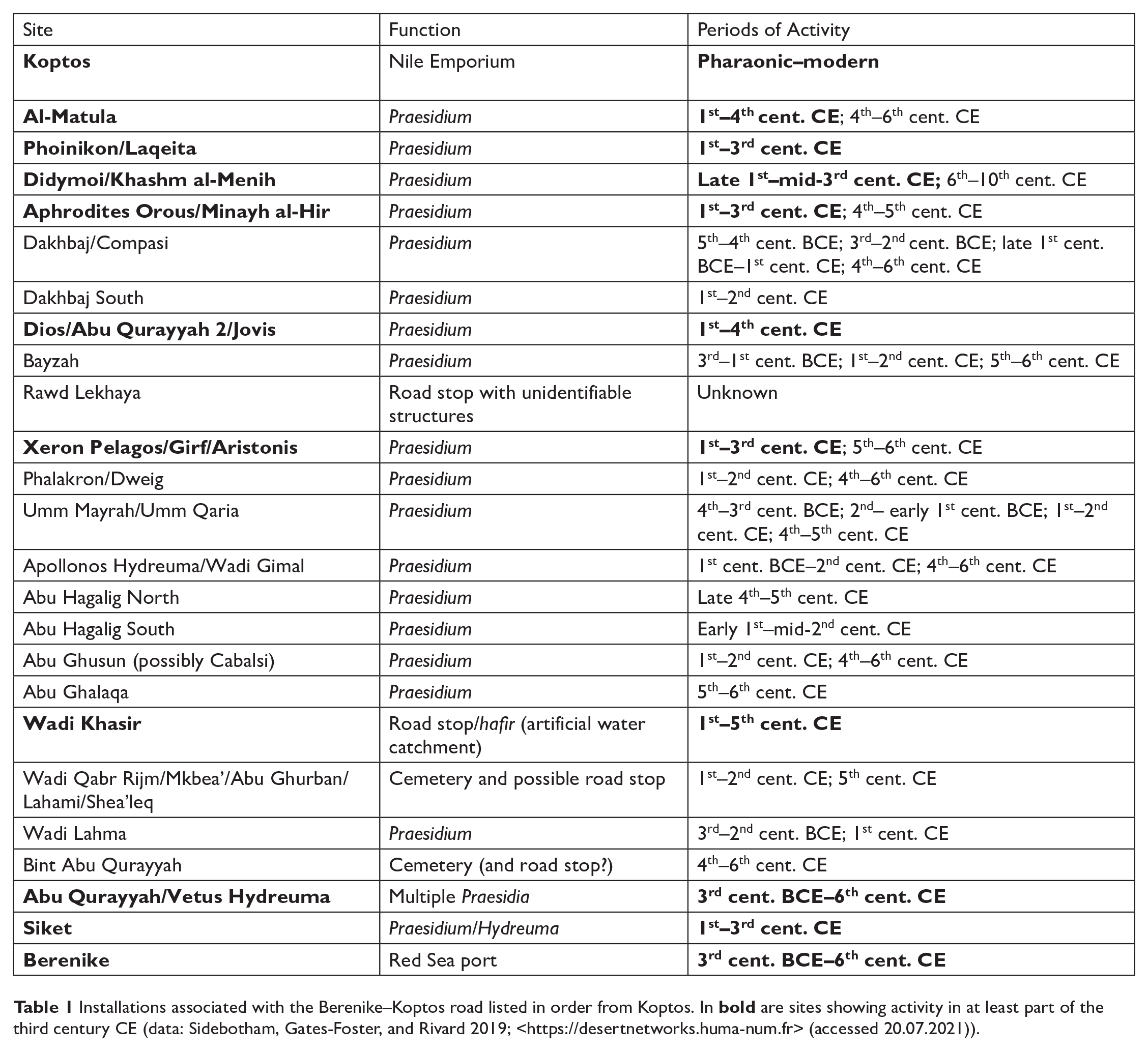
Didymoi’s fort was built in the last quarter of the first century CE, abandoned in the mid-second century CE, and refurbished and reoccupied in the late 170s CE (following Marcus Aurelius’ visit to Alexandria in 176 CE) until a second abandonment in the second quarter of the third century CE. 66 Ceramics from Aphrodites Orous/Minayh al-Hir date from the first to third centuries CE, but the third century pottery is, again, not decisive; surveyors suggest abandonment in the third century CE and fourth century CE reoccupation. 67 Around the station at Dios, activity extended from the first century through to the fourth century CE; however, at the fort, the latest ostraca dates to Phillip the Arab (248–249 CE), demonstrating that imperial presence probably discontinued in the third quarter of the century. 68 In Dios’s last phase of occupation, grain silos and milling structures were installed, as were large baking ovens. 69 Similar changes are seen at Xeron Pelagos, as excavations showed that in the final phase of occupation (the third quarter of the third century CE) much of the fort’s living quarters were vacant, a bakery was established, grain silos were installed abutting the front of the fort (presumably to store grain for baking bread), and other rooms were converted to animal stalls. 70
Analysis of scattered surface pottery at the Wadi Khashir station demonstrates activity from the first to the fifth centuries CE, but, since the station was never fortified, it may be that its water catchment was used by passers-by in the Middle and Late Roman periods. 71 Abu Qurayyah (possibly Kainon Hydreuma) had five praesidia: three that fell into disuse by the end of the second century CE (and were reoccupied in the Late Roman Period), and two that remained occupied from at least the Early Roman through to the Late Roman periods. 72 At Siket, the final praesidium before Berenike, survey and excavation show a period of occupation from the late first century BCE to the third century CE; but Sidebotham and Wright think surface remains dating to the Middle Roman Period are from random visitors, as excavation revealed far more activity in the Early Roman Period. 73
Why some stops on the Berenike–Koptos road were abandoned by the third century CE and others remained in use is unclear. Without further excavation it is also unclear to which part of the third century CE certain ceramics belong. Given the slight evidence of imperial activity around the mid-third century CE at Dios and Xeron Pelagos, it is plausible that road stations – such as those at Abu Qurayyah and Siket – were occupied by Roman officials at the same time; or, material remains could be from non-Roman inhabitants, such as the so-called barbaroi, the Blemmyes, or other Eastern Desert peoples – the evidence from Berenike helps us zero in on this question. Overall, the archaeology demonstrates that traffic along the road declined between the late second and early third centuries CE, followed by imperial withdrawal from the road in the third quarter of the century.
Berenike
Berenike was arguably the most important Red Sea port in Roman times. Archaeology exhibits a long history, stretching from the third century BCE to the sixth century CE. 74 Berenike functioned as a commercial port simultaneously with Myos Hormos in the Early Roman Period, and, like Myos Hormos, activity waned in the later second and early third centuries CE. 75
Evidence from the Early Roman Period – in the form of organic material, ceramics, documentary evidence, and some architectural remains – showcases a dynamic centre of exchange between the Roman Empire and societies of the Indian Ocean. 76 At some point in the second century CE (probably the third quarter), Berenike became less lively. Evidence from the later second century CE is minimal – few recognisable coins, little epigraphic evidence, and very small amounts of pottery – and material from the third century CE is even less. 77 The latest documentation for military presence is from the so-called ‘Shrine of the Palmyrenes’ (fig. 5), where two dedicatory inscriptions – one by a Palmyrene archer to the cult of Caracalla and Julia Domna (215 CE), and the other dedicated to a Palmyrene god and mentioning a Roman military commander (180/185–212 CE) – are evidence of the port under imperial control (at least via Palmyrene auxiliaries) until the first quarter of the third century CE. 78 Sidebotham, who has been directing excavations at Berenike for three decades, says, ‘Little is known about the Middle Roman period when Berenike suffered a nadir in its fortunes.’ 79
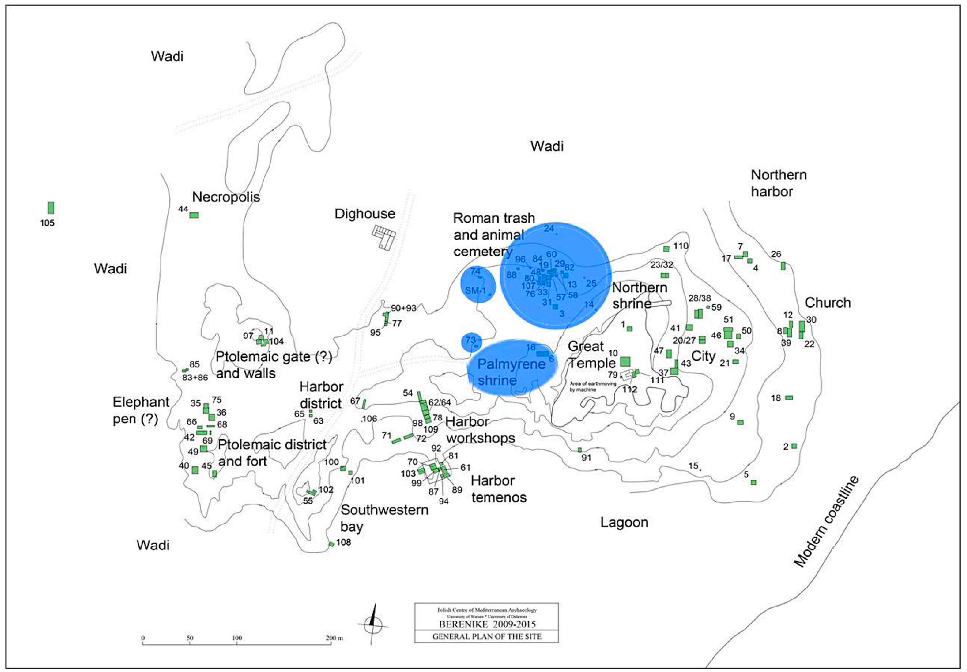
Plan of Berenike. In blue are indications of Roman military presence from the first to early third centuries CE (map: Sidebotham 2018: 607, fig. 5; drawing by Berenike Project).
Yet, unlike most of the sites reviewed above, archaeological evidence proves that Berenike remained inhabited through the third century CE into late antiquity. Material remains uncovered north of the Great Temple, from Phase XIV of Trench 10 (fig. 5), demonstrates an industrial metalworking area dating to the late second and third centuries CE. 80 But while Berenike was not completely abandoned, activity so radically diminished in the Middle Roman Period that we know next to nothing about who was occupying the port.
Berenike experienced a resurgence in the mid-fourth century CE, as the port underwent largescale renovations that included the first documented residential structures, pointing to an influx of new inhabitants and an uptick in commerce. 81 Finds from recent excavation seasons suggest that the port may not have been under direct Roman control in the Late Roman Period, but instead controlled by the Blemmyes of southern Egypt (possibly ruling in a proxy role) by at least the fourth century CE. 82
Via Nova Hadriana
The Via Nova Hadriana was another major Roman thoroughfare of the Eastern Desert, commissioned by Hadrian in the 130s CE. Connecting Berenike with the city of Antinoopolis, the road stretched 800 km along the Red Sea coast, then ran west across the northern portion of the desert to the Nile metropolis (fig. 1). 83 Some of its stops have already been discussed, as the highway intersected with other roads and each Red Sea port. Sidebotham thinks that the road’s main function was administrative, given the lengthy journey from the ports and disadvantageous course from the major quarries. 84 If this is true, it would explain why just four of the road’s 26 associated stops – Makhareg (well), Tal’at al-Arta (road station/well), Abu Sha’ar al-Qibli (praesidium associated with the fort at Abu Sha’ar – below), and Abu Qurayyah (above) – produced post-Severan third century CE evidence. 85 As a thoroughfare designed for imperial administration, at this point in our analysis it would be odd to see much mid- to late third century CE activity along the Via Nova Hadriana given the Roman state had withdrawn from nearly everywhere else in the first half of the century.
Additional sites
The quarries and fort 45 km south of Mons Claudianus – the various installations associated with the quarries collectively referred to as Mons Ophiates – were the next largest of the Eastern Desert after Porphyrites and Mons Claudianus. 86 Ceramics from Mons Ophiates show a period of occupation between the first and early third centuries CE – chronologically in line with much of the Roman Eastern Desert. 87 Mersa Nakari (probably ancient Nechesia), the small Red Sea port between Myos Hormos and Berenike, may have been a Ptolemaic foundation, but thus far all evidence found is from the first/second century CE and fourth/fifth century CE. 88 Most sites along the road connecting Mersa Nakari with the Nile emporium Apollonopolis Magna produced material remains from the Ptolemaic and Early Roman periods, and a few sites have Late Roman evidence, but no remains date to the Middle Roman Period. 89 About 40 km southwest, inland from Mersa Nakari, a survey of settlements associated with the major green beryl/emerald mines Mons Smargardus showed just one of the eight sites (Sikait) was active in the period under discussion, while at the rest, activity either broke down in the late second/early third century CE until the Late Roman Period, or started in the fourth century CE. 90
Discussion
It is not surprising that the functional low point in the Eastern Desert coincides with the so-called Crisis of the Third Century. However, the archaeology demonstrates that the intensity of activity reduced significantly in the late second and early third centuries CE. In 2018, Tomber showed, via archaeological evidence, that the Eastern Desert was still as important to the Roman state in the second century as it was in the first century CE, focusing her investigations on principal sites such as quarries, ports and mining settlements, and less so on the desert routes. 91 She does note shifts in activity occurring in the later second and early third centuries CE, but her aim was to show trade was still taking place in the second century CE, ‘not to debate the relative intensity of trade between the first and second centuries’, thus less attention is paid to late second century CE reductions. 92 The evidence presented in this study makes clear that the Eastern Desert was in decline in the latter half of the second century CE. It can be argued that the Antonine Plague, the Roman-Parthian War, and the Roman Empire’s long war with the Marcommani in central Europe each, to varying degrees, contributed to the region’s recession – the pandemic causing general economic disruption and population losses throughout the Empire, impacting activity in the Eastern Desert (either directly or indirectly), and the wars (especially the nearby Roman-Parthian War) redirecting imperial priorities elsewhere.
Written evidence tells us that the Roman army brought the Antonine Plague to Asia Minor in the mid-160s during Emperor Lucius Verus’ campaign against the Parthians, and thereafter it spread throughout the Roman Empire (probably lasting until around 180 CE); in fact, a number of ancient authors link the Antonine Plague to the army and its movements. 93 There is, however, written evidence of a pestilence in Arabia during the reign of Antoninus Pius. 94 The account is corroborated by an inscription recording the pestilential ruin of Gawr (modern Bayt al Ahraq) on the southern Arabian side of the Red Sea coast, which claims that the disease destroyed ‘the whole land’ in the mid-150s CE. 95 While we have no way of knowing if the pathogenic culprits responsible for the Arabian pestilence and the Antonine Plague were one and the same, their near spatiotemporal concurrence along with waning activity gleaned from the archaeology of the Eastern Desert may be clues that our focus region played an early role in the Roman Empire’s pandemic. 96
As shown, major sites including Mons Claudianus, Porphyrites, Myos Hormos and Berenike produced considerably less material evidence from the latter half of the second century CE compared to the preceding period. Each of those sites and their supporting routes to the Nile had a stable military presence up to the mid-second century CE. Tomber noted that the reductions in activity and military occupation at Mons Claudianus occurred before the Antonine Plague, in the mid-150s CE; but the written and inscriptional evidence recounting the Arabian pestilence were not considered. 97 Building most likely reduced in Pius’ reign following the extensive building programmes of Hadrian, which may in part explain the mid-150s CE pause at Mons Claudianus. That cannot, however, account for the near 30-year silence at a premiere imperial quarry. It is noteworthy that Mons Claudianus remained virtually inactive until Commodus’ reign – i.e., at the pandemic’s end and after the wars. At Porphyrites, activity at all quarry settlements except for the site’s administrative fort halted or reduced by or during the second half of the second century CE. Reductions in Eastern Desert quarrying is mirrored by low activity along the quarry roads and by a dearth of external evidence for Claudianus granodiorite and Porphyrites porphyry used in imperial building in the later second century CE. 98
Looking elsewhere in Egypt, papyrological evidence from Lower Egypt indicates that the Antonine pandemic probably had a direct impact on activity in the province. There is evidence for rises in wages and prices, as well as tax and census documents that demonstrate considerable losses of population coinciding with the pandemic. 99 In general, there is little direct written evidence for the Antonine Plague, and most papyrological documents (taxes, receipts, landholdings, censuses, etc.) are not typically records in which one would find explicit mention of disease. 100 However, the single direct reference to the Antonine Plague in Egypt qualitatively reveals much about the pandemic’s presence in the province. P. Thmouis 1.104 (168–169 CE), a tax arrears document, refers to a disease outbreak at the village of Kerkenouphis in the Nile Delta as part of ‘the pestilential situation’ (τῷ .λοιµικῷ καταστήµατι) – demonstrating a well-known disease with an influence wider than the village. 101 It is thus probable that the Antonine Plague had an indirect impact on activity in the Eastern Desert, as travel to the region via the Lower Nile would have been disrupted in the midst of a virulent disease outbreak. And since we have clear written evidence for widescale epidemics in both Arabia and Egypt in the 150s and 160s CE respectively, it is plausible that disease had a direct impact on the Eastern Desert, too.
As with the quarries and their roads, the pandemic and geopolitical engagements may be responsible for transitions in activity at the Red Sea ports and at the hydreumata and praesidia on their support roads to Koptos – all collectively acting as a gateway for maritime trade with the east. Shifting networks of exchange, as proposed by Young, Tomber, and Nappo respectively, are also likely playing a role. 102 However, we must ask why trade patterns changed. Palmyrene activity rises in both commercial and military capacities in the desert and at the ports in the late second and third centuries CE, attested via inscriptions at Koptos and Berenike. 103 Of course, Palmyra was effectively a component of the Roman Empire in the second century CE and even became a colonia in the Severan Period, and Rome regularly used Palmyrene auxiliaries in its army. 104 However, rising Palmyrene presence in the Eastern Desert coinciding with reduced imperial presence demonstrates a Roman-directed change. Young suggested that Palmyrene activity in Egypt increased as a result of Verus’ Parthian War (taking place near Palmyra), in turn altering Red Sea trade. 105 That is plausible, and at the same time the Roman-Parthian War could be why we see shrinking military presence and abandonment of Eastern Desert sites previously manned by the Roman army. Additionally, Cobb notes that ostraca from the Red Sea–Nile road stations and Mons Claudianus reveal that northeast African tribes, particularly barbaroi – the main term used by the Romans between the late first and late third centuries CE in referring to nomadic tribes of the Eastern Desert – were encroaching on the region in the late second century CE. 106 This coheres archaeologically with modifications attested at fort stations of narrowed or blocked-off entryways and sealed windows. 107 With the general reductions in imperial activity observed in the archaeology, cohorts of Palmyrenes and barbaroi in the area give an impression that Roman military authority and Roman-driven Indian Ocean trade were on the decline from the late second century CE. 108
The downturn continues in the first half of the third century CE, as Myos Hormos and many more desert road stations are fully abandoned, while Berenike goes quiet. Quarrying at Mons Claudianus and Porphyrites does pick up again in the Severan Period, particularly in Caracalla’s reign (211–217 CE), but not to the extent of the Early Roman Period, and activity comes to a halt in the second quarter of the century. In the third quarter of the century, ostraca signify Roman pacification of barbaroi through grain distributions at praesidia along the Berenike–Koptos road, coinciding with the installation of grain silos and bread ovens at those same praesidia (above) – illustrating fading Roman authority and increasing tribal presence in the region. 109 This is supported by new evidence showing the nomadic occupation of Bir Samut on the Berenike–Edfu road around this time (fig. 1). 110 Save for slight activity at Berenike that may or may not have been Roman, the Roman state abandons the Eastern Desert before the end of the century’s third quarter – probably a result of both tribal incursions and Palmyrene queen Zenobia’s annexation of Egypt in 270 CE. 111 Inscriptional evidence found during the 2019 excavation season at Berenike hints that the Blemmyes, or other indigenous peoples of the Eastern Desert, may have laid claim to the port after Zenobia took Egypt. The inscription – a dedication on behalf of a Blemmye king – probably dates to the fourth century CE, but with indigenous groups moving on the region in the 260s CE, and no Palmyrene evidence in the desert after 264 CE, it is plausible that Eastern Desert peoples took control of Berenike in the late third century CE. 112
Following the rise of Diocletian (284 CE) and the tetrarchy, the Roman state returns to the Eastern Desert, mainly in the area of Porphyrites. In setting out to reorganise the Egyptian frontiers, Diocletian laid siege and caused serious damage to Koptos before eventually recapturing it from the Blemmyes in the mid-290s, and he moved the southern Egyptian border north to Philae/Aswan, the latter coinciding with a Blemmyan peace treaty. 113 He installed a legionary fort at Thebes/Luxor (301 CE) and built the fort at Abu Sha’ar (late third/early fourth century CE) on the northern stretch of the Red Sea coast (fig. 1) to police the area, after which northern Red Sea ports Clysma and Aila become Rome’s main facilitators of Indo-Mediterranean commerce. 114 No return to Mons Claudianus, Myos Hormos or Berenike (the latter not in an official imperial capacity), the northward movement of defenses and maritime traffic, and peace with the Blemmyes demonstrates that the Roman state had effectively relinquished the Eastern Desert south of the Porphyrites–Nile road.
Conclusion
Evaluating the archaeological evidence from the Eastern Desert showcases rapid growth and a dynamic commercial region in the first two centuries of Rome’s occupation of Egypt, followed by regression, neglect and abandonment in the Middle Roman Period. While shifting patterns of trade may have in part played a role in the transition, abruptly declining activity at a few important locations (e.g., Mons Claudianus, Berenike, Myos Hormos and its road) suggests something significant occurred in the late second century CE. The wars, particularly the Parthian War, could have been a catalyst. The more remarkable coincidence is that the start of the transition occurs simultaneously with a neighbouring Arabian-wide epidemic – possibly an early outbreak of the Antonine Plague. Whether the disease spread from Arabia to the Eastern Desert or vice versa matters not; it is unlikely that the Eastern Desert – an inlet and outlet of trade with Arabia and south Asia – was unaffected (directly and/or indirectly) by a largescale epidemic attested just across the sea. Of course, we do not know if the Arabian pestilence and the Antonine Plague were caused by the same pathogen. But their contemporaneity, the archaeology from the Eastern Desert, and the epidemic mortality occurring in Egypt a decade later (linked to the Antonine Plague), hint that the disease responsible for the second century CE pandemic reached the Mediterranean via the Red Sea/Eastern Desert, earlier than its spread through western Asia with the Roman army in the mid-160s CE. 115
Further archaeological fieldwork in the Eastern Desert is necessary to precisely pinpoint periods of transition at certain settlements, but the general trend of late second/early third century CE decline is clear. Examining the region’s archaeological evidence over the longue durée exposes this juncture as a turning point. The Roman state’s authority and investments diminish from this moment, leading to the encroachment of Eastern Desert tribes and the Roman Empire’s eventual withdrawal from the area. Whether it was a pestilence, distant geopolitical engagements, shifting patterns of trade, or a combination of these factors, the archaeology shows that a major transformation was underway.
Footnotes
Acknowledgements
I am grateful to Steven Sidebotham, Sabine Huebner, Matthias Stern and Andrew Wilson for their comments on earlier versions of this article, and to the anonymous reviewers of JEA for their helpful suggestions. Any errors of fact or interpretation are my own.
Funding
This research was carried out with funding from the Swiss National Science Foundation under project number 192176: ‘The Roman Egypt Laboratory: Climate Change, Societal Transformations, and the Transition to Late Antiquity’.