
Abstract
The Sudanese Eastern Desert or the ‘Atbai’ is still largely unexplored from the point of view of rock art surveys. As part of the Atbai Survey Project’s fieldwork program, surveys conducted in 2018 and 2019 identified new rock art sites in the deserts around Gebel Nahoganet. Findings included a large tableau of a boat ‘fleet’ along with numerous sites yielding faunal rock art and surface remains. While a generalized boat motif is relatively commonplace in the corpus of rock art from Egypt and Nubia, this specific type of boat encountered in this distant desert exhibits a number of unique features. Notably, the tableau is carved within the walls of a natural tunnel and the features and manner of its execution have few parallels elsewhere. This contribution introduces the hypothesis that these boat motifs may have been the products of local Nubian groups including the A-Group horizon (c. 3800–3100 BCE).
Introduction
The Eastern Desert of Sudan, commonly referred to as the ‘Atbai’, is a vast desert expanse known for its goldmines and as the homeland of nomadic groups. Within this desert, the topography, ecology, and local archaeological material differs appreciably. On the main range of the Red Sea Hills, nearing the coast, many large cemeteries and nomadic habitation sites occur, owing in part to the regularity of orographic rainfall and water sources in the base of wadis. Contrasting this ecology are the interior deserts closer to the Nile River and west of the Red Sea Hills, sometimes called the Awliib or Atmur in Beja, 1 which exhibit much flatter topography punctuated with inselbergs, sand-dunes, and numerous rocky plateaus and a much sparser record of habitation in historical periods. In the nineteenth century, this region became well-known as the area of the ‘Korosko Road’, an established caravan path providing a shortcut through the Nile bend linking the settlements of Korosko and Abu Hamed.
As part of the broad aims of the Atbai Survey Project, two seasons (2018/19) of rock art surveys were conducted in the region of the flat deserts between Gebel Rafit and Wadi Halfa, especially around the massif of Gebel Nahoganet and Nasb Enat. 2 Owing to the extreme aridity of this region, habitation sites post third millennium BCE are extremely ephemeral in nature and can be generally attributed to the expeditions of goldminers and foreign expeditions. Multi-period nomadic occupations are attested at the few specific sites where surface water is available. 3 The exception to this pattern is the great proliferation of sites of Mesolithic and Neolithic date which are comparatively common in the Atbai’s flat Atmur wastes. Many inselbergs and rock-shelters reveal scatterings of pottery from these periods, and it is likely that much of the rock art repertoire, the majority being faunal in nature, belongs to this phase of habitation. 4 As with other ‘Saharan’ rock art zones, the types of fauna indicate an altogether wetter environment than the hyper-arid present, with conditions suitable for a variety of African savannah fauna like the giraffe and even elephant. The ubiquity of cattle in the rock art record suggests that the region was occupied by cattle pastoralists until an as yet unknown date, possible as late as the third or second millennium BCE. 5 After this point, decreasing rainfall rendered cattle pastoralism impossible. The specific desert region east of Wadi Halfa is in fact so arid and devoid of watering opportunities that it is rarely used by pastoralists today. Only seldomly are camel and goat herders to be found in this Atmur desert, usually around the wells at Murrat. 6
While this desert region has undergone some archaeological surveys in the past, its vast expanse, remote nature, lack of roads, and the extreme difficulty of logistics has meant that many sub-regions still remain to be surveyed. The most notable of these past surveys were conducted by the CeRDO (Centro Ricerche sul Deserto Orientale) missions directed by Angelo Castiglioni, Alfredo Castiglioni, and Karim Sadr. These surveys identified a huge number of archaeological sites including rock art locales, Pharaonic inscriptions, goldmines, and cemeteries. 7 Follow up missions by the Sudan Archaeological Research Society (SARS) have elaborated on many of these sites, especially those exhibiting Egyptian hieroglyphic and hieratic rock inscriptions. 8 Commenting on the density of sites, Angelo and Alfredo Castiglioni guessed that their discovery of 200 sites represents a drop in the ocean of a theoretical 18,000 sites across the region. 9
Methods and Context
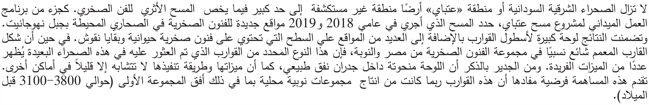
As part of the broader aims of the current Atbai Survey Project in investigating the relationship between foreign expeditionaries and indigenous nomads, fieldwork seasons in 2018/19 aimed to survey rock art sites that lay on hypothetical routes between the Lower Nubian Nile and the interior desert through means of vehicular survey along clusters of inselbergs south and north of Gebel Nahoganet and the ranges west of Nasb Enat (fig. 1). The fieldwork expedition consisted of two all-terrain vehicles and seven to eight members, with a primary focus on GPS recording and photography of rock art sites. Concerted and focused epigraphic work was limited due to issues of logistics, supplies (fuel, food, water), and time constraints. As with previous surveys in this desert, due to the truly prolific expanses of suitable rock surfaces for rock art and the vast distances involved, this survey cannot make a pretence to having exhaustively found sites along the survey’s route. Rather the survey’s methods should be held to be indicative of the kind of density of rock art sites that exist across the Atbai Desert, with the fieldwork designed to elucidate and record as many sites as possible in the context of the ongoing destruction to the local heritage by modern goldmining operations as well as vandalism. In total, in two seasons of vehicular surveys, the Atbai Survey Project was able to identify 23 new sites, most of which contained rock art and others typified by scatters of surface artefacts, chiefly ceramics and lithics.
New sites discovered in the Atbai Survey Project (red dots) with sites surveyed by previous missions in yellow dots. The purple line is the route of the 2018 season and the blue line the route of the 2019 season.
Initial rock art discoveries by the Atbai Survey Project 2018 season indicated that the desert was traversed by ‘Nile dwellers’ well before the imperialistic ventures of Egypt’s administrations in the Middle and New Kingdoms. 10 Data for this penetration includes a large tableau of ‘Predynastic boats’ at the site of Gebel Maraekib (AS18.27), which dates to the phase of Naqada IID–IIIA according to the relative chronology established for predynastic Egypt. 11 The following discussion presents some new and major rock art discoveries as well as broader considerations of the rock art corpus encountered in two seasons of surveying. Due to ongoing risk profiles and evidence of vandalism at local archaeological sites in this part of the Atbai, this report has been deliberately vague in regards to the publication of exact GPS coordinates. 12
The ‘Boat Tunnel’ at Site AS19.26
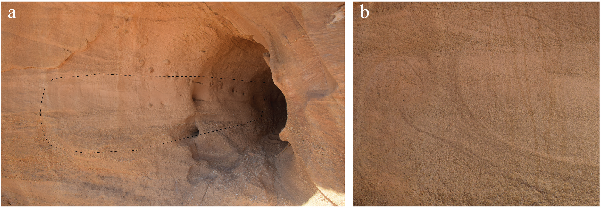
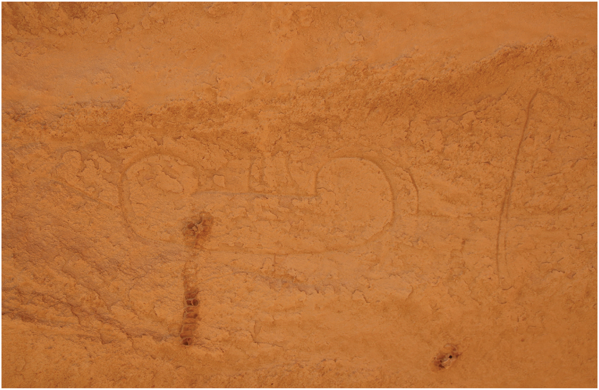
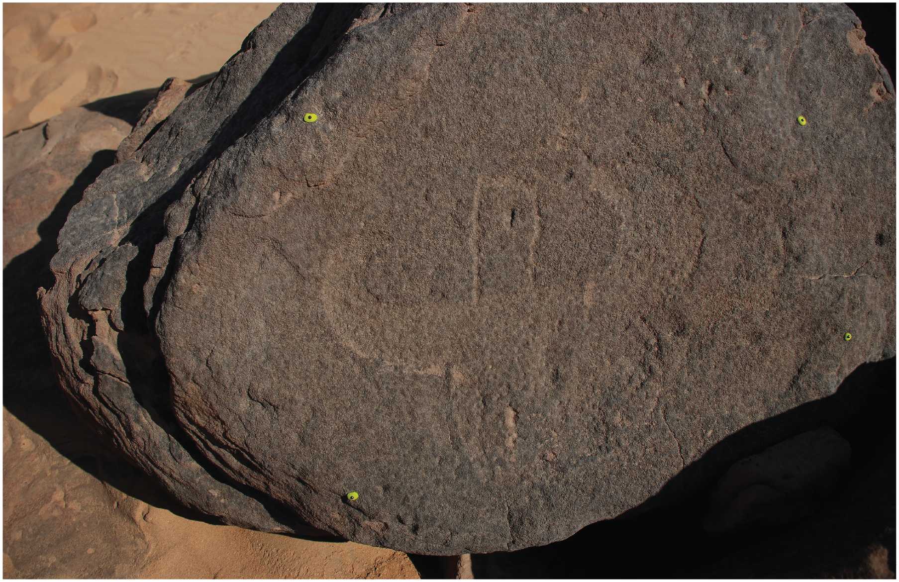
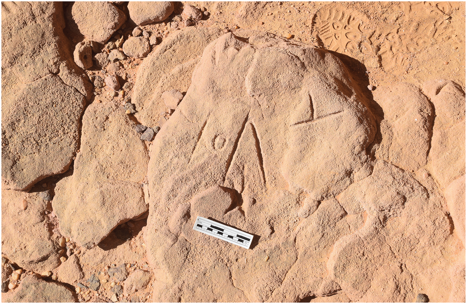
On a series of small inselbergs (rock-island outcrops) south of Gebel Nahoganet, approximately 150 km from the nearest section of Nile, the survey identified four new rock art sites mainly exhibiting faunal depictions. However, one of these sites, AS19.26, exhibited a notable feature in depicting a large group of at least six boats, reproduced along a horizontal axis of over two metres on the western wall of a small natural rock-tunnel that leads to the centre of the inselberg. A single boat depiction was also produced on the other side of the tunnel on the eastern wall, almost as far back in the tunnel as is feasibly traversable by an ancient artist. In all, there are nine discernible features on the main ‘western’ wall. Six of these features can be identified as boats and the remainder are somewhat enigmatic in composition.
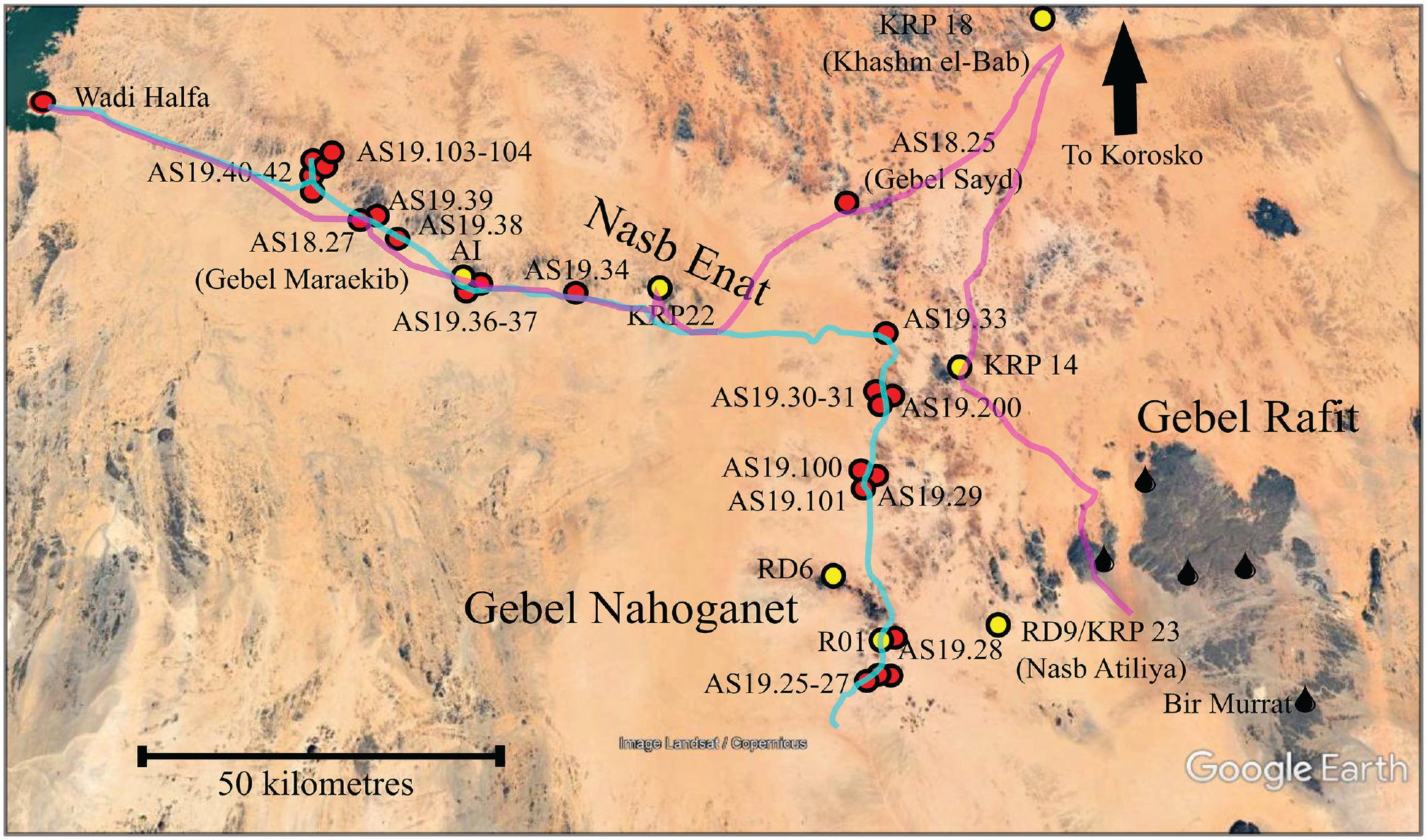
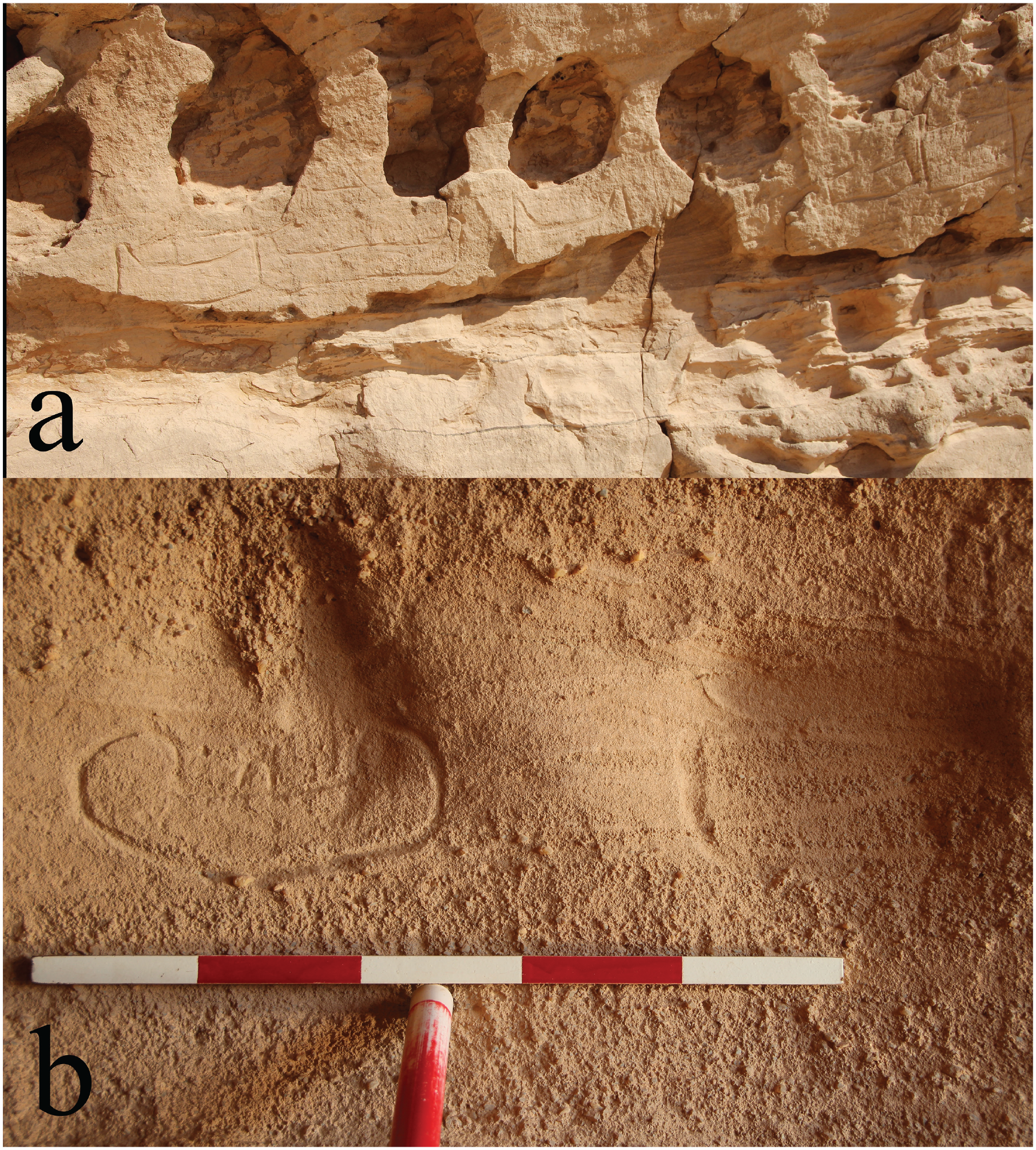
These boats were arranged in an exceptionally unique manner on the rock surface in that they were depicted along the walls of the tunnel (fig. 2a and b). The tunnel is a little over a metre in height and opens out into a natural rock shelter protected by a series of large boulders on the south side of the inselberg, making the site in all probability suitable for habitation and refuge, shielded from the prevailing north wind. The curved nature of the rock surface as well as the cramped conditions made epigraphic recording exceedingly difficult, requiring instead digital epigraphic methods. Access to the tunnel requires climbing, a process that presumably was also true for the ancient rock art maker(s), although it is impossible to ascertain the height of the ancient shelter floor from our reconnoitre. The survey identified no occupation debris on the surface of the shelter, although future excavation could yet reveal a logical habitation for this sheltered area protected from the dominant north-wind.
(a) The ‘tunnel’ at AS19.26 with (b) detail of features 1 and 2 (see fig. 3). The boat carvings extend from the mouth of the tunnel to the interior, with details showing the method of relief execution.
The boats at AS19.26 (nos 1, 2, 5, 7, 8, 9) are arranged in the manner of a ‘fleet’ or ‘flotilla’, all seemingly emanating from the tunnel interior. The style of execution is also quite unique; the boat outlines are not scratched or finely incised but rather the edges of the motifs are carefully moulded and depressed so as to give an impression of ‘raised-relief’. In total there appears to be six boats on the ‘west-side’ of the tunnel and a rather smaller and less carefully executed boat on the east side of the tunnel. Not all of the motifs present on the tableau are easily attributable as ‘boat’ motifs. Two round or circular shapes (nos 3 and 4 in the image) occur under the boat ‘fleet’, executed in the same style of ‘relief’ as the boats. There are some oblique incised lines in the middle of the tableau (no. 6), all of which have an uncertain meaning. The smaller ‘L-shaped boat’ (no. 5) is executed in a different style and technique, consisting of sharper incised-lines. A series of very finely incised lines on top of this boat are difficult to explain with known repertoires of boat imagery. This different manner of execution could purport to a different time at which this boat was carved than the main tableaux (earlier, later) which exhibit a consistent construction, but ultimately such suppositions are conjectural. As the prow and sterns of these boats are identical, and there are no rudders or sails, the sailing direction or orientation of this ‘fleet’ is not discernible.
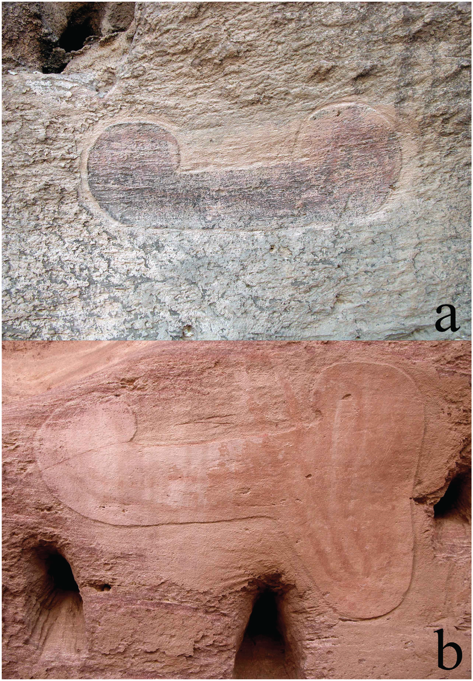
The boats have a distinctive style when compared with other boat depictions in the rock art corpus of Egypt and Nubia, having a roughly flat bottom, thick hull, and a protruding prow and stern flanking a flat deck (fig. 3). Some of the boats exhibit a central structure on the deck (nos 2, 9), likely a cabin, executed in a similar manner of style to the hull but with less care, making their outline sometimes difficult to follow. Most of the boats are depicted in a horizontal orientation although one of them seems to flank a boat on an oblique angle (no. 1). This orientation does not seem to be a space-saving measure on the ‘stone canvas’ given the free space to the left of this boat. The ancient rock art makers not only selected the greater tunnel context carefully but also took care to avoid a large natural hole in the centre of the tableau. They also deliberately carved their depictions on the sandstone layers which were fine-grained, giving a neater execution to the scene. Both above and below the boat depictions are extremely coarse-grained layers ill-suited for carving. Indeed, some of the depictions appear to disappear in the coarse layers below (nos 1, 3, 4, 8). In two boats (nos 7 and 8), the rock art maker also used natural horizontal cracks for the hull in lieu of carving deliberate lines. 13 These considerations give the impression that this tableau was not quickly executed without thought but was carved with some degree of care and consideration, taking time to accomplish the desired scene.
Line drawing and orthophoto of the boat tableau at AS19.26, numbers refer to distinct features in the tableau (orthophoto: Paul Wordsworth).
The practice of using appealing geological features in the landscape such as tunnels, shelters, natural ‘basins’, ‘hydraulic depressions’, niches, or even large natural cracks/gaps into a rock surface is not exceptional and is attested both in Egypt and Nubia. 14 Many other attestations are certainly still waiting for scientific recognition. However, such an intense and well-thought-out use of the walls of a rocky tunnel is surprising. The possibility that rock surfaces were decorated during the Predynastic Periods in a similar manner to temple walls in subsequent ages should be taken into account but, based on current data, it remains impossible to concretely link most rock art sites with cult places and/or worship per se. It would be tempting to raise considerations regarding this ‘tunnel symbolism’ and how it could be related with certain Pharaonic religious conceptions, particularly with the idea that this composition might suggest a celestial or subterranean navigation akin to the persuasive myth of the solar boat and cycle, or even the notion of the caverns at the source of the Nile at Elephantine. The relevance of such comparisons with later Egyptian religious symbolism is limited, however, because the corpus of Predynastic rock art has thus far yielded no such obvious comparisons with later Pharaonic mythic symbolism. Furthermore, the identity of the rock art makers, whether they were Nubians, Egyptians, or ‘Desert Peoples’ cannot be ascertained with certainty. The typology of these quite atypical boats is not of assistance in this case. As far as one can tell, it looks like the boats are sailing towards the entrance of the tunnel, so from the inside to the outside.
Many uncertainties prevent us from providing a secure interpretation of this fleet. What can currently be safely affirmed is that boat symbolism, well attested in the Nile Valley, 15 was part of the cognitive baggage of the rock art makers and that the practice of depicting boats as bearers of ideological and symbolic discourses extended far into the Eastern Desert of Nubia. Because these boats do not offer any of the classical structural features reminiscent of the ‘official’ Naqadan boats, whose typology is very standardised in Predynastic iconography, 16 it is reasonable to consider that they are not an expression of order and political control in this particular case. Moreover, these boats look like simple constructions, 17 closer to regular ‘daily boats’ than to large elite processional vessels. This provides a hint as to the identity of the rock art makers, who were probably not present in this remote section of the desert as government officials, but were arguably rather ‘common people’ conveying popular traditions through rock art. A Nubian origin would then seem plausible but this possibility does not come without obstacles. Because we know so little about fourth millennium BCE Nubian traditions and beliefs, any suggestions regarding the original function and meaning of this fleet would be highly tentative.
Parallel Boat Sites in the Sudanese Eastern Desert
Further examples of these boats, albeit in smaller numbers, have been identified in the desert locally around Gebel Nahoganet. At site AS19.100, a massif consisting of three large and connected sand-filled shelters opening to the southwest, the 2019 survey identified another example of these ‘flat-bottomed’ boats (fig. 4) in the central (middle) shelter (AS19.100.3). The single boat here is almost identical in morphology to those at AS19.26 in respect to the prow, stern, and the central cabin. Only the roof of the shelter and parts of the back wall were visible due to large deposits of wind-blown sand, thus making it uncertain if other boats or depictions could have been carved. This site also contained numerous (>20) other depictions, mainly of cattle, other indistinct quadrupeds (caprids?), and anthropomorphs, also including a rare example of a painted cow and human figure (see below).
A boat on the roof of the shelter at AS19.100 (photo: courtesy of Derek Welsby).
Similar boats were identified by the CeRDO missions at sites RD6 and RD9 (= KRP 23 in the SARS Survey). 18 The site of RD6 is on Gebel Nahoganet itself, while RD9 is at the edge of a large playa on an inselberg known as Nasb Atiliya. The boats at RD9/KRP 23 reproduce two different styles in two different contexts, both of which have similarities to those at AS19.26 (fig. 5a–b). One style is a boat that is roughly rectilinear in shape with small vertical protrusions at the prow and stern, reproduced at least seven times (KRP 23 site 7); the other is almost identical to those previously discussed AS19.26 and AS19.100 in that it possesses a single boat with a curved prow and stern (KRP 23 site 2). Interestingly, both these boat tableaux at KRP 23 were executed within the walls of two tunnel-like caves, just like the ‘tunnel fleet’ AS19.26. 19 Both locales at RD9/KRP 23 exhibit a boat with a central cabin. The one boat at KRP 23 site 2 has a cabin, and from the extant photographs a single boat of KRP 23 site 7 exhibits a cabin.
Boats at site RD9/KRP 23, a) site 7 and b) site 2 (photo: courtesy of Derek Welsby).
While not visited by the Atbai Survey Project, photographs of site RD6 depict at least six boats in a different array of shapes. The standard ‘flat-bottomed’ and wide hull boat known from the other sites is depicted (fig. 6a), but so too there is a boat with a large protrusion on the right side (fig. 6b). The manner of execution with a raised-relief technique is identical to AS19.26. Enigmatic drawings showing a similar structure with incurved extremities and a protrusion underneath one of its sides are attested in two boats at Wadi Rasras, in the desert east of Aswan (fig. 7), and also in Wadi Abu Subeira (fig. 8). These possible parallels are notable given the Nubian context, especially in regards to Wadi Rasras’ rock art and location, which testifies to the use of desert roads connecting Nubia and Egypt by groups with different cultural affiliations. Associated with the boat, this protrusion might evoke the face of a cow, with the horns being suggestive of the boat itself. It is especially striking to note that this protrusion is more often than not located underneath one extremity of the boat and is not, as one would expect, centred. A parallel depiction of a bull’s head on a pole is famously attested on a wavy-handled jar from the Naqada IIIA tomb U-j in Abydos (fig. 9). Bulls and boats were important and symbolically prevalent iconographic motives in Egypt and Nubia during the fourth millennium BC, 20 both of which are connected to notions of political power and control. Such a combination of the two motifs in a single symbol could then be tentatively suggested. 21 However, the protrusion is far from being recurrent and we fail to see the justification of the presence of a cabin, if it is indeed a cabin at all. This exceeds the scope of this paper and remains to be further discussed.
Boats at site RD6: a) a ‘flat bottomed’ boat and b) a ‘protrusion’ boat (images: courtesy of the Alfredo and Angelo Castiglioni archive, Castiglioni Museum, Varese).
Similar incurved structures with a lower protrusion recently documented in Wadi Rasras (image: courtesy of Maria Gatto, ©AKAP).
Similar incurved structure, most probably a boat, with a lower protrusion underneath the hull, from the Wadi Abu Subeira near Aswan (site KASS 1) (photo: Alberto Urcia; courtesy of Lauren Lippiello).
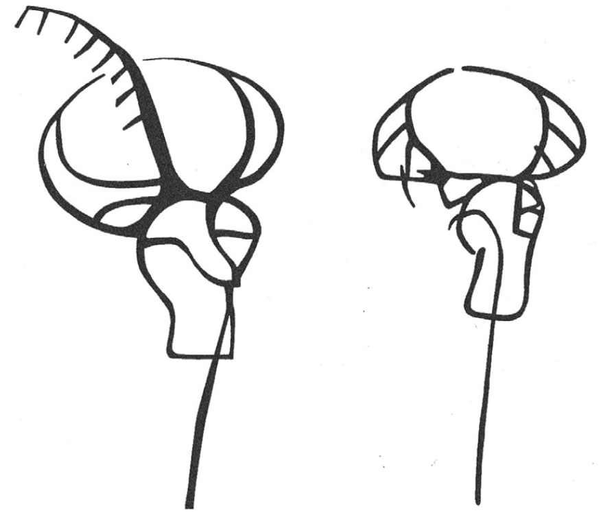
Depictions of bull’s head on a pole from tomb U-J in Abydos (after Dreyer 1998: 65, fig. 45).
Two of the boats at RD6 contain painted decoration, which is an exceptional feature in the Predynastic rock art repertoire of boats. 22 The red paint within the regular flat-bottomed boat (fig. 6a) seems to depict a slightly different shaped boat. It seems possible then that one ‘layer’ of boat iconography was executed on top of another layer after the initial production in a type of rock art palimpsest. However, since the left half of this internal painted boat is too indistinct to offer clear information, any comparative analysis is highly tentative. How and why the rock art makers executed this painted decoration is unclear. The ‘protrusion boat’ at RD6 (fig. 6b) also contains red ochre painted decoration executed after the initial boat carving – in this case the painted decoration constitutes a series of red lines which trace the interior shape of the boat. These internal red lines are still entirely enigmatic, perhaps the two painted strokes that are emerging in and out of the boat could designate rudder oars. This hypothesis is supported by the fact that these two lines are highlighting a previously worked section of the rock. Unfortunately, we do not possess photographs of a high enough resolution to safely trace the internal painted lines in detail.
A New Boat-Type in Eastern Nubia
Despite some variations, these flat-bottomed boats with incurved extremities are nevertheless consistent and numerous enough to consider that they belong to a distinct typological category. 23 Following these desert surveys and past publications, similar boats have been found across four sites in the Atbai Desert, as well as four sites in Upper Egypt, with the largest cluster occurring in the ‘boat tunnel’ at site AS19.26. Similar boats with very rounded ends and/or a narrow and curved or pointed central cabins are attested in the Aswan region, in Wadi Shatt el-Rigal and Wadi Abu Subeira, 24 and also at the ‘Mini-Mid’ site west of Thebes. 25 Because one example in Wadi Abu Subeira is partially covered by a Naqada IIC–D boat type, these boats are best attributed to the Naqada IA–IIB period. They could also be older, although this appears quite unlikely in regards to our current knowledge of Predynastic rock art chronologies. Very rare and typologically atypical, this boat type has been omitted in recent studies dedicated to Predynastic boat images and does not appear in old typological categorisations. 26 Boat depictions on Early Dynastic seals and ivory labels discovered at Abydos could be mentioned as parallels since some consist of flat-bottomed structures with extremely incurved extremities (fig. 10). 27 However, one should not be too quick in drawing such conclusions since most, if not all, daily boats used by people along the Nile were mainly built with vegetal material and the extremities were all more or less incurved because of the need to strengthen them by having a rope fixed to the deck. 28
Ivory jar-label from the tomb of king Narmer in Abydos, Pennsylvania Museum, inv. E9396 (after Vandier 1952: 837, fig. 560).
The ‘rectilinear boats’ with small protrusions on the prow and stern (fig. 5a) bear a striking resemblance with one category of boat models, sometimes labelled ‘axe-boats’ because their extremities resemble the profile of an axe blade. 29 The problem is that this category of production only offers a limited number of models and they are very different from the known corpus of Predynastic arts and crafts. Moreover, all of these artefacts originate from the antiquity market and are thus deprived of any archaeological context. Because of these weaknesses, the antiquity and authenticity of these models remains uncertain. 30
Such a concentration of these new boats across four sites in the Eastern Desert of Nubia (AS19.26, AS19.100, KRP 23/RD9, RD6) suggests that these boats belong to a specific iconographic, albeit rare, tradition. Correspondingly, it seems likely that the boats are the products of a specific and as yet unknown group. Because these boats appear in the desert and in areas connecting the desert with the valley, it is possible that they have been engraved by non-sedentary people closely connected with the deserts.
Who Created these Boat Petroglyphs?
Based on the current state of knowledge from surveys in this region, it is reasonable to assume that these boats constitute a kind of local cluster in the distant desert over 100 km from the Nile (fig. 11). Although one should note our knowledge is largely restricted to the direct paths of vehicular surveys in this desert, which in no area is complete or comprehensive. 31 Our resolution is, however, far better on the Nubian and Egyptian Nile, so we can state with some confidence that this specific shape and style of boat depiction is limited to a smaller number of sites.
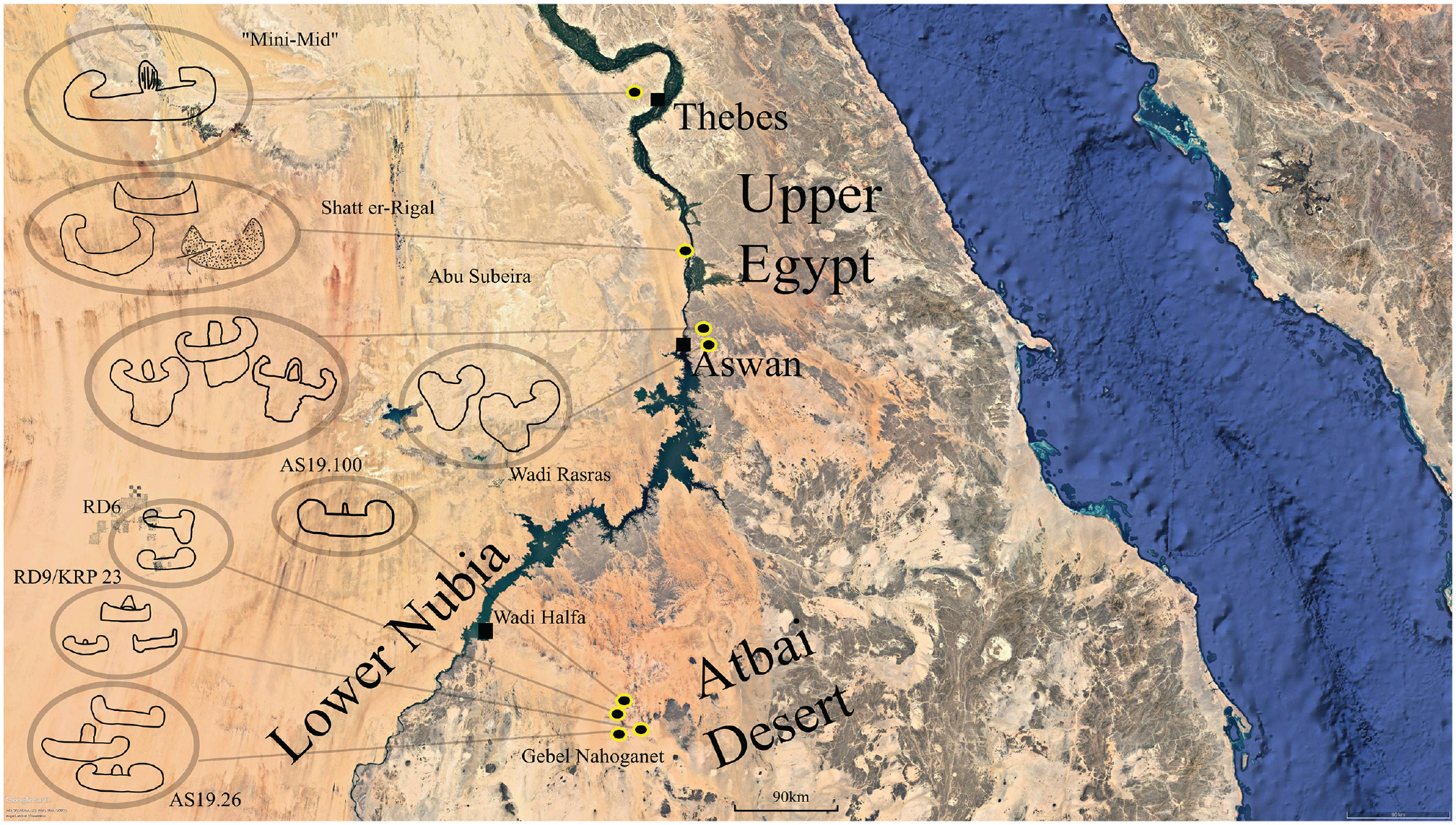
Map of rock art sites in the Atbai Desert of Lower Nubia and Upper Egypt with discussed enigmatic boat scenes (map: © Google Earth).
It is not easy to ascribe these specific boat depictions to any individual cultural grouping, although a ‘Nile connection’ seems likely based on the importance of the boat as a motif of riverine culture. A likely date of Naqada I (c. 3900–3650 BCE) does not readily help. These sites are a great-distance from the Nile (c. 130–150 km), and while ‘Naqada-like’ representations are known from the large tableau at ‘Gebel Maraekib’ (Naqada IID -IIIA), these depictions are almost double the distance from the Nile. If one proposes that these boats are attributable to the Naqada culture of Upper Egypt, one must also explain why Naqada people are in such a distant desert away from their homeland. As with later phases of resource exploitation in the Pharaonic period, gold exploitation could be a plausible motive for Nile dwellers to travel into this desert. Gold is not common in Predynastic contexts until Naqada III, although gold finds such as beads are attested as far back as Naqada I. 32 The proximity of other gold-bearing areas to the Naqadan and Upper Egyptian homeland makes the supposition that Egyptians directly ventured to this distant gold-bearing area at such an early period pragmatically unlikely. Perhaps a more plausible explanation then is to connect or attribute these images to local Nubian groups centred in the Nubian Nile Valley and/or the Atbai Desert. Based on the presence of Neolithic burials amongst auriferous ores in Wadi Elei, including a find of gold wire in the burial, Sadr has suggested early gold exploitation in the Sudanese Eastern Desert extending as far back as the fourth millennium BCE. 33 This hypothesis implies that early ‘experiments’ in gold exploitation were taking place. Gold objects are also attested in A-Group burials, most famously embodied in the gold-leaf mace head from Sayala. 34
There is every possibility that the boats are attributable to local Nubian groups which would likely, at this date, include people ascribable to the A-Group horizon. The A-Group has a core region on the Lower Nubian Nile north of Saras, extending into southern Upper Egypt, and is also – importantly for this discussion – known to extend deep into the Western Nubian Desert, with A-Group contexts known from Kurkur Oasis, Laqiya, and Wadi Shaw. 35 Thus far no unequivocal A-Group site has been identified in the Eastern Desert, even if the idea of an ‘Eastern Desert A-Group’ has been postulated as part of a likely semi-nomadic and possible seasonal subsistence pattern. 36 Local pottery traditions of the fourth millennium BCE Atbai do bear a resemblance to A-Group traditions, although they are not similar enough to make this relationship unproblematic. 37 Only with future surveys will this issue of the peopling of the desert in this chronological horizon be solved.
The presence of A-Group sites in the Western Desert demonstrates that this culture’s regional extensions included desert regions as well as those of the Lower Nubian Nile. The ‘A-Group connection’ to these boat images might also explain the distribution of parallel examples of these flat-bottomed boats at Wadi Shatt el-Rigal, Wadi Abu Subeira, and Wadi Rasras, all desert routes connecting Nubia and Upper Egypt. Furthermore, the boat motif is a recognized feature of ‘A-Group’ iconography, being present in seals, pottery decoration, and rock art. 38 It should be stressed here that in the time of the A-Group (fourth millennium BCE), pastoralists may still have found ephemeral grasslands and periodic surface water in this desert east of Lower Nubia. Roughly similar latitudes in the Western Desert still received some of the northerly reaches of the African monsoons as documented by surveys at sites like Wadi Shaw, Laqiya, and Wadi Hariq. 39 Accordingly, it is likely that a continuum of pastoralists, with their cultural or demographic ‘centre’ on the Nubian Nile, were able to exploit grazing-lands in both the Eastern and Western Deserts in a seasonal nature – and it is indeed possible that these pastoralists engaged in special economic activities such as procuring gold and other minerals while in the desert. Perhaps then it is these ‘Nile-desert’ pastoralists who are responsible for these boat depictions. It is worth remarking here that any pastoralists striking east from the Second Cataract region would need to traverse the inselbergs and sand seas of this exact region around Gebel Nahoganet in order to reach the more dependable water resources and pastures further east at Gebel Rafit, Bir Murrat, and Wadi Gabgaba.
Other Sites on the Eastern Desert Surveys of 2018/19
In addition to the rock art sites discussed above, the surveys around Gebel Nahoganet also discovered a number of new rock art sites as well as sites exhibiting scatters of surface artefacts, in particular around the region of Nasb Enat. The rock art at the majority of these sites featured faunal depictions, usually cattle and various types of quadrupeds, most likely gazelle or ibex. There were also images of the human figures engaged in hunts or even what appears to be a human holding a scythe and a ‘swimmer’. Stone floors of rock shelters frequently exhibited so-called ‘tally-marks’ as well as ‘scoops’ or ‘cupules’, curved depressions sometimes showing secondary marks of scraping. Both of these features are likewise frequently encountered at rock art sites along the Nile in Nubia and Egypt as well as the Western Desert. 40
In terms of local context, almost all these petroglyphs were carved or painted in rock shelters within inselbergs or sometimes executed on prominent vertical rock walls. Associated surface finds usually demonstrate Mesolithic and Neolithic occupations of these sites, including sherds and tools such as grinders and grinding slabs (millstones) (fig. 12). The decorative patterns on the ceramics employ various techniques such as the rocker and pivot techniques, well-documented in the region from the CeRDO surveys. 41 Outside the shelter at AS19.100, one scatter of sherds, likely from the same vessel, included twelve repair-holes (fig. 12d). At the base of a wadi (AS19.104), the survey found a spherical lithic instrument, probably a bow-drill holder (capstone) or, less likely, a mace head (fig. 12e). Grinding slabs and grinders were also relatively commonplace at rock art sites. Based on these distributions, it might be tempting to directly link the authors of the rock art with these Neolithic habitations, but as these rock shelters and caves had a highly functional purpose of shelter, visitation of these sites endured throughout the millennia. The surveys also found limited evidence of Graeco-Roman era activity in the form of sherd scatters at two sites, AS19.38–39 (fig. 12c), probably to be ascribed to local desert paths accessing the goldfields. One of the surveyed sites also yielded an example of ‘Middle-Nubian’ pottery (AS19.36), that is wares belonging to the C-Group, Kerma, or Pan-Grave horizons of the second millennium BCE.
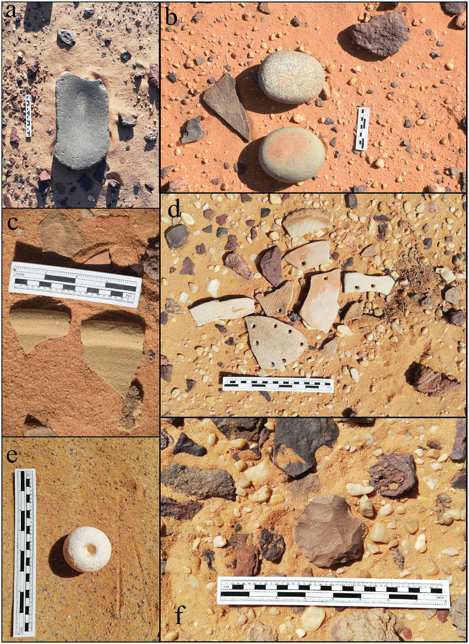
Surface artefacts identified on the 2019 season survey: a) grinding slab, b) grinders, c) Graeco-Roman sherds, d) Neolithic sherds, e) a bow drill holder (?), and f) lithics (core).
Some temporary dwellings were encountered on the survey in the form of hut-bases, usually marked by only one course of stones. The largest agglomeration of hut-bases was at site AS19.42 (fig. 13c), a site which unfortunately yielded very few surface artefacts in our reconnoitre. Inselbergs also sometimes exhibited stone-cairns on their summit (fig. 13b), although as a recurrent and long-lasting feature in desert routes, one cannot be wholly certain on their date. 42 At some sites (AS18.27; AS19.38; AS19.40), due to the presence of surface remains and rock art, particularly tally-marks, it seems reasonable to assume that these cairns were erected for the purpose of ancient expeditions following established desert routes. An analogous use of cairns (alamat) is well-known on Pharaonic desert tracks such as the Abu Ballas trail southwest of Dakhla Oasis as well as on desert paths in the Wadi Arabah leading to copper mines that were exploited in the Old and Middle Kingdoms. 43 A somewhat unique feature identified in the surveys were small boxes made from unshaped stone on wadi floors (fig. 13a). Their function and date is wholly unclear, but a similar stone-box has been identified in the Atbai at the site of Bir Nurayet further east towards the Red Sea coast, which was used to store ceramic figurines. 44
Surface features identified on the 2019 season survey: a) a stone box, b) a rock cairn, and c) a dry stone hut base.
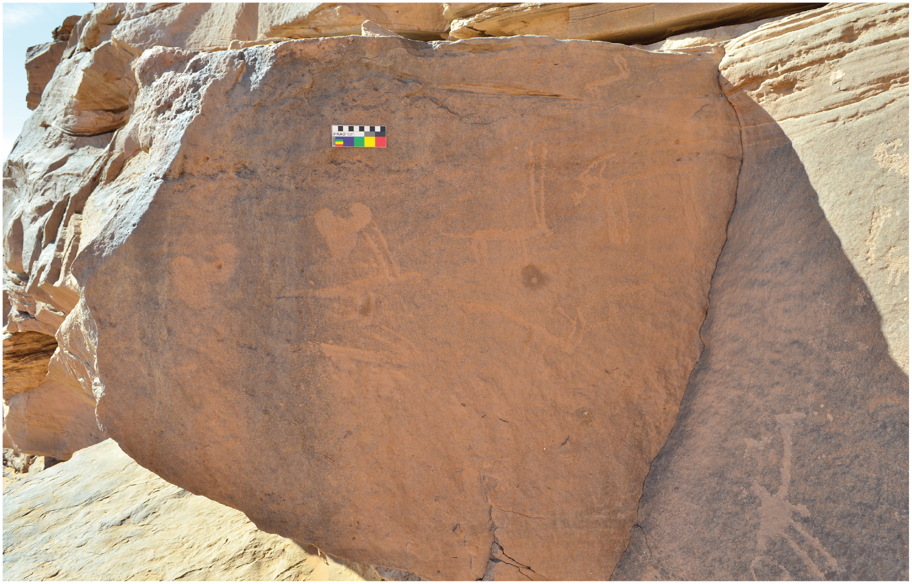
Some sites in this survey are worthy of further elaboration and investigation due to the exceptional content of their rock art. Site AS19.100 constituted three large, interconnected rock shelters, largely filled with sand, whose extant surfaces contained diverse scenes of anthropomorphs, fauna, tally-marks, and a boat. The easternmost shelter also exhibited a unique image of a painted cow with an enlarged udder beside a similarly executed human in the easternmost shelter, situated somewhat separately from the rest of the rock art in a small recess (fig. 14). The human, clearly part of the same composition, is positioned a bit below the cow and seems to be holding a vessel or object.
Painted rock art at site AS19.100.
Stylistically, this cattle depiction has much in common with styles present in the Western Desert and Sahara such as the Ennedi, Gebel Uweinat, and Gilf Kebir. 45 The depiction of the human in such a scene is likely connected to the act of milking, indicative of the kind of pastoralist activities that took place in this now hyper-arid desert. The head of the cow appears to have been deliberately damaged. This kind of ‘damnatio’ or iconoclasm of cattle is an attested feature in prehistoric rock art of the Sahara, 46 and likely constituted a practice which was part of the same prehistoric cultural system which produced the rock art – in other words it is not a modern act of vandalism. This same pattern of deliberate damage was also applied to the human figure. Apart from the aforementioned painted boats, painted rock art is relatively rare in the Eastern Desert and Nubia. The most notable ‘painted tableau’ is found at a shelter near Korosko, and painted cattle have been recently discovered at Wadi Rasras east of Aswan. 47 Painted rock art is also a common feature further southeast in the Red Sea Hills near Port Sudan, as well as the highlands of Eritrea. 48 The painted tableau at Wadi Rasras, near Aswan, displays a cow with a prominent udder, making it possible that there once existed a painted pastoralist-style of rock art attested across the entire Atbai, poorly defined because it is somewhat rare and has not yet been documented comprehensively due to the paucity of surveys. 49
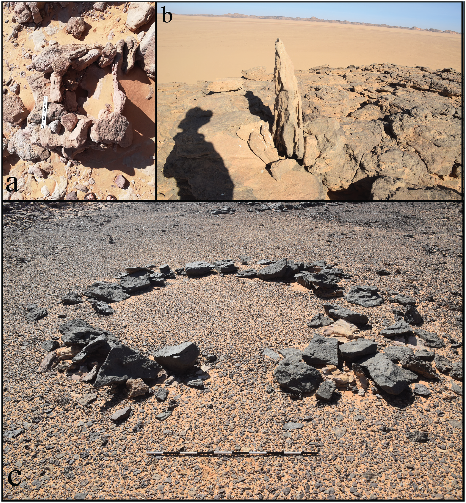
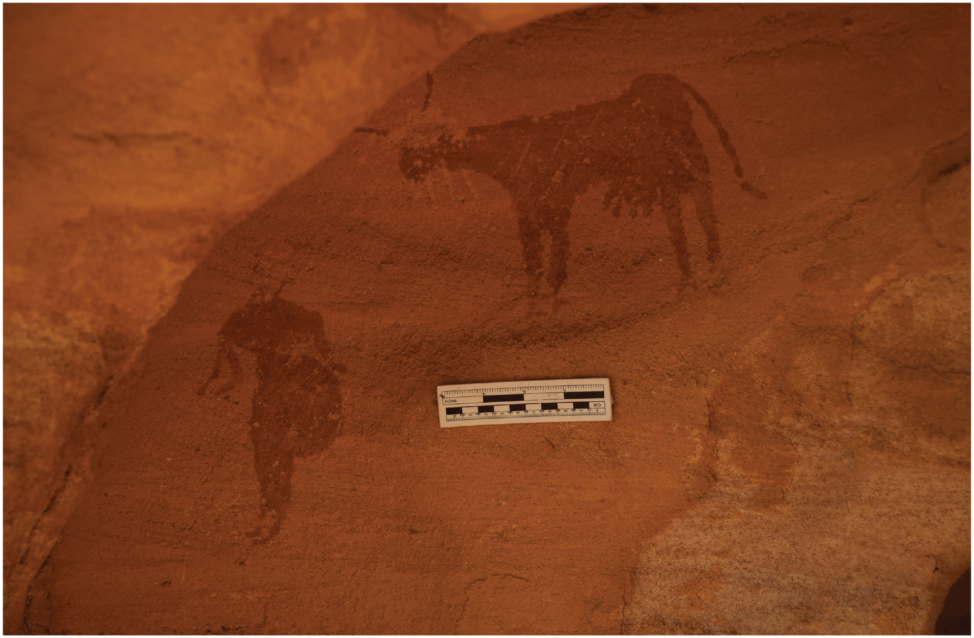
Site AS18.25 consists of a large rock shelter in a visually prominent inselberg, strategically situated at the bottom of a pass that winds up to a section of higher desert plateau. This site ‘Gebel Sayd’ was previously described by the present authors, noting a hunting scene and faunal representations, particularly cattle, antelopes, and giraffes. 50 Continued analysis of this site reveals the presence of more depictions at the rear of the rock-shelter, in an enclosed cave with extremely friable and poor-quality rock (fig. 15a–b). Two features are discernible on this surface, one is a series of lines that appear to be painted on the rock with some kind of ochre, the other is a set of thick incised lines below and to the left of the painted lines. Both are not easy to interpret. The ochre lines, now appearing as a beige or cream-colour, were subjected to enhancement with Dstretch software which indeed shows a series of concentric curved lines. 51 Such a pattern of concentric curved lines occurs in the rock art repertoire elsewhere in the Nile Valley, with several examples published in the Scandinavian concession in Lower Nubia, as well as one example in the Third Cataract, and others at El Hosh in Egypt. 52 In these cases, the authors largely considered this motif an example of late Palaeolithic or Epipalaeolithic rock art, somewhat discouraging a comparison here where the rest of the cave seems to contain Neolithic imagery. In shape and form, these painted lines also appear reminiscent of the so-called ‘Naqada Plant’, a common motif on decorated pottery of the Naqada Period occurring with other ‘Naqadan’ iconography, although given the debates relating to the meaning of this image, any comparison should be considered putative and speculative. 53 In the case of this rock wall in the Atbai, the choice of painting rather than carving may have been motivated by the extremely poor nature of the rock and its friable surface. The preservation of the ochre is likely a result of the fact that this image is at the interior wall of the cave shielded from the elements. The other feature on the rock surface is a carving which appears as a single deeply incised line on a diagonal axis, with two further lines arising from its top. In general shape it recalls the body of a bird, although the features nearing the ‘head’ are extremely difficult to adduce. Although it cannot be certain, there is a possibility that this represents a rendering of the Egyptian Horus bird, a falcon – but this should not be submitted as a wholly certain interpretation as there are no suggestive comparisons with the known corpus of Pre- or Early Dynastic falcon imagery. 54
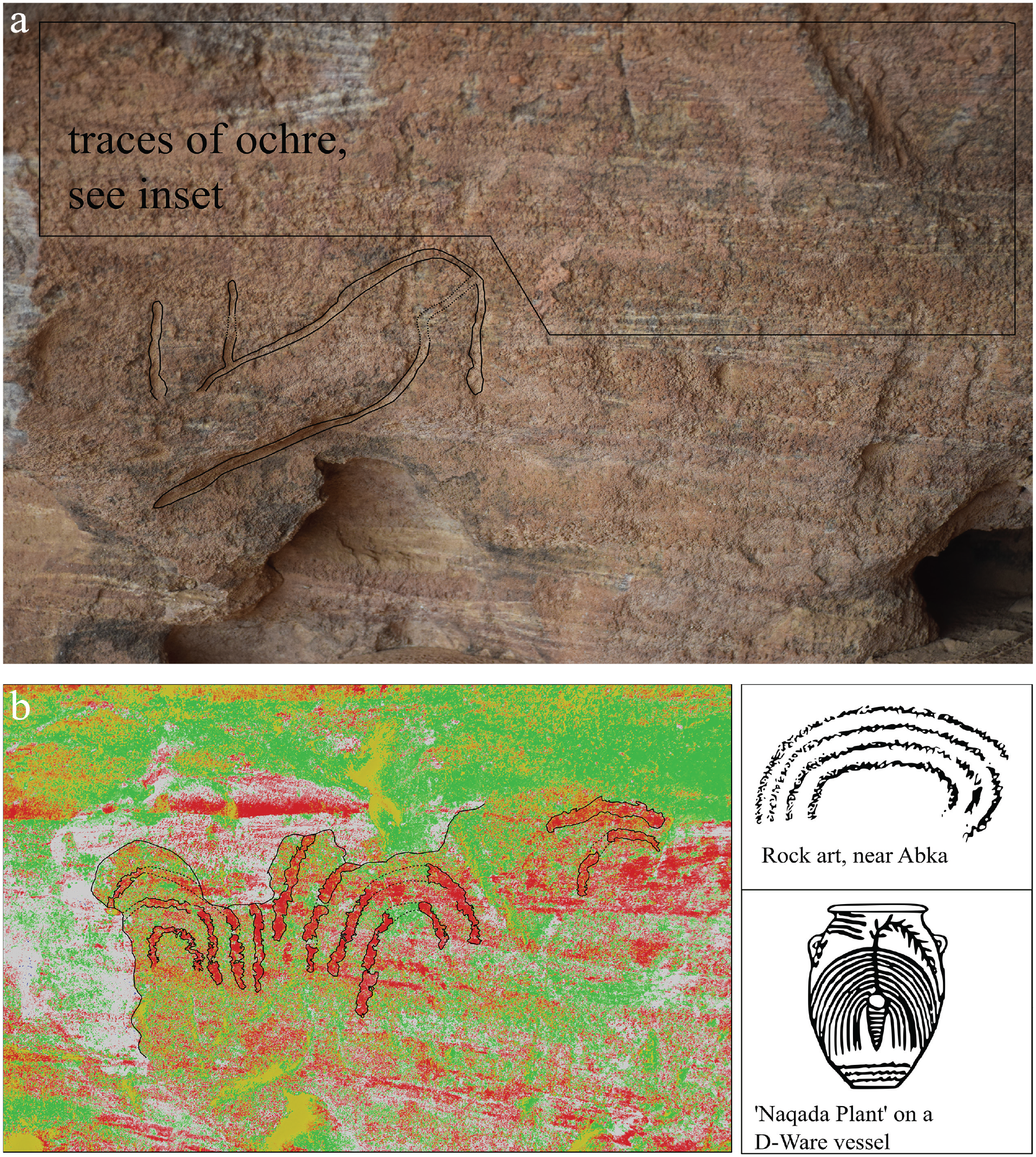
a) Rock art in the rear cave at ‘Gebel Sayd’ with b) an inset picture subjected to Dstretch visualisation alongside parallel motifs from a Naqada D-Ware vessel (Petrie and Quibell 1896: pl. XXXIV.36a) and a rock art site in Lower Nubia (Hellström and Langballe 1970: II, X35).
Arabic numerals carved alongside a common wusum.
Site AS19.31 consisted of a shelter overlooking an east-west wadi, one of the few wadis in this desert that bears some vegetation in the form of a cluster of acacia trees. Instead of the regular faunal representations, the main feature at this shelter were camel brand markings (wusum), carved into the base of the shelter and on loose rocks. Such ‘camel brands’ are common features in the rock art of Egypt and Nubia, especially in desert regions, but are infrequent in this hyper-arid desert where even camel nomadism could only be practiced with extreme difficulty. Alongside these camel brand icons, the Arabic numerals for ‘158’ (١٥٨) or possibly 751 (٧٥١, in reverse orientation) is repetitively carved into several rocks on at least nine different surfaces. The purpose of marking these numerals is uncertain, but as these numbers are placed alongside the camel brands, it is reasonable to assume that it belongs to a similar cultural system as the wusum and may even likewise be an identifying mark. 55 MacMichael remarks that sometimes camel brands in Sudan used ‘numbers’ to spell the name of a tribal sheikh using a system called ‘Abjad numerals’, a type of code where letters in the Arabic alphabet were afforded a particular numerical value and thus a ‘name’ could be spelt with numbers. 56 He gives the example of the sheikh’s name ‘Ḥussein’ being spelt with the number ‘118’ = (ḥ) ح 8 + (s) س 60 + (n) ن 50. The alternative numbers (158, 751) are not currently known to ‘spell’ an Arabic name so it is uncertain whether this is its purpose here. Some tally-marks and cupules were also found in the same shelter, indicating the shelter was likely in use well-before the period when camel brands were carved. 57 The period of camel brands is usually considered to date to Late Antiquity and the Medieval Period, and perhaps this locus of activity is a result of the grazing opportunities present in this wadi in an otherwise barren and treeless desert, as well as the presence of a desert track.
Summary
Surveys in the Atbai Desert continue to reveal new sites that elucidate a range of features relating to Neolithic habitation, penetration of Nile groups in the terminal Prehistoric, as well as the expeditions of Egyptians in the Dynastic Period. It is expected that continued surveying and localized excavations at key sites in the Eastern Desert will shed more light on the patterns of habitation and exploitation in different epochs. An anecdotal observation from our surveys is that most inselbergs and rock shelfs do indeed contain some vestige of human habitation whether in the form of rock art or surface remains of lithics and ceramics, especially those pertaining to the Neolithic Period, a not unexpected feature given our palaeoclimatic models of a drying Sahara. The findings of this research suggest the possible transhumance of Lower Nubian (A-Group) or other Nile peoples far into the interior of the Eastern Desert, bringing with them a familiar set of motifs connected to their life on the Nile. At present it is impossible to generalize much more on the authors of this boat imagery given our haphazard and patchy record of surveys. It could be that this A-Group transhumance was the last embers of an ancient para-Nilotic nomadic pastoralism that existed before conditions ultimately dried to their present state in the fourth millennium BCE, creating more accentuated barriers and greater regional distinctions between the Nile and desert worlds.
Footnotes
Appendix: Gazetteer of sites
This gazetteer includes a brief table with notes on newly discovered archaeological sites, chiefly rock art locales, surveyed by the Atbai Survey Project in 2018 and 2019.
Acknowledgements
We are indebted to the Museo Castiglioni, Serena Massa, Marco Castiglioni, Derek Welsby, John Darnell, and Maria Gatto for sharing data from their rock art surveys. The Atbai Survey Project thanks the National Corporation of Antiquities and Museums, Dr Abdelrahman Ali (Director General), and Hozaifa Abdelmagid (inspector) for their support. We are also indebted to Vivian Davies, Derek Welsby, Julie Anderson, and the Sudan Archaeological Research Society (British Museum). The Atbai Survey Project 2018/19 fieldwork teams consisted of Julien Cooper, Derek Welsby, Vivian Davies, Pierre Meyrat, Hozaifa Abdelmagid, Kefilwe Rammutloa, Rebecca Whiting, Saleh Mohammed Saleh, Mubarak Adam, Khaled Mahmoud Fartag, and Osman Dafalla. We are further grateful to Paul Wordsworth for producing an orthophoto of the rock art.
Correction (Feb 2024):
Article title updated to present in full. See DOI: 10.1177/03075133241235512.
Funding
The 2018/19 Atbai Survey Project was funded by the Gerald Averay Wainwright Fund, the Egypt Exploration Society Fieldwork Grant, and William K. and Marilyn M. Simpson Egyptology Endowment.
1
For the ecology of these regions, see Abd el-Ati, et al. 1996: 37–58 and ![]() : 1–8.
: 1–8.
3
4
Gatto 2012: 42–57; ![]() : 68–70.
: 68–70.
5
For discussion, see Bobrowski, et al. 2013: 135–142.
6
Lepsius (1853: 137–142) noted Ababda and Bishareen nomads in this region. ![]() : 138) describes conflicts between the Bishareen and Ababda over control of the local wells at Murrat.
: 138) describes conflicts between the Bishareen and Ababda over control of the local wells at Murrat.
7
Consult the site gazetteers in Castiglioni, et al. 1998: 177–186.
8
Davies 2020: 185–220; ![]() : 131–163.
: 131–163.
10
By the term ‘Nile dwellers’, we mean the prehistoric inhabitants of the Egyptian or Nubian Nile, or those connected with Nile cultures such as the A-Group and Naqada horizons.
12
13
A feature also witnessed at the nearby site of ‘Gebel Maraekib’, cf. Cooper and Vanhulle 2019: pl. 5. For a parallel with natural features used in the implementation of rock art, see also ![]() : 61 (site 17 R XVIII-1).
: 61 (site 17 R XVIII-1).
14
For shelters, see Suková 2015: 119–143. For rock art in basins, see Morrow, et al. 2010: 63–68 and depressions, see Lippiello and Gatto 2012: 267–292. Natural niches are documented in Gatto, et al. 2009: 9–57 and natural cracks in Darnell 2011: ![]() .
.
17
Nilotic boats were designed with flat-bottoms, thus with a very limited draft of water, in order to avoid hidden underwater sandbanks or similar obstacles. It also allowed sailing in shallow waters.
18
Castiglioni and Castiglioni 2020b: 50–51; ![]() : 158–160.
: 158–160.
20
Wengrow 2001: 91–104; ![]() : 275–318.
: 275–318.
22
The only other published example is located in the Wadi Hammamat and can be attributed to the Naqada II Period, see Rohl 2000: 127. There are also examples in the later productions at Korosko and Khor Rahma published in ![]() : 58–72, 100–108.
: 58–72, 100–108.
23
24
See Caminos and Osing 2021: 193, pls 72, 84B, 84D, 90D, 91B, 91E (?); ![]() : tab. 1.
: tab. 1.
25
26
27
Petrie 1901: 20–21, pl. XI.2; Hartung 1998: 189–190, 213, figs 2, ![]() .3.
.3.
28
32
For discussion of Predynastic gold mining, see Klemm and Klemm 1994: 193–194. For the earliest gold finds in Naqada I contexts, see ![]() : 390.
: 390.
34
Nordström 1972, I: 20–21; Roy 2011: 282–283. ![]() : 25) has reservations that the A-Group engaged directly in gold exploitation and rather sees A-Group gold objects as Egyptian in manufacture.
: 25) has reservations that the A-Group engaged directly in gold exploitation and rather sees A-Group gold objects as Egyptian in manufacture.
35
Darnell and Darnell 2013: 35–52; ![]() : 105–127.
: 105–127.
36
Sadr, et al. 2004: 196; Nordström 1972, I: 27; Gatto 2006: 71; ![]() : 125–142.
: 125–142.
39
Jesse, et al. 2004: 123–164.
40
Cooper and Vanhulle 2019: 9 n. 9. For their possible function, see Polkowski, et al. 2013: 101–118.
41
Lanna and Gatto 2010, I: 319–328; Sadr, et al. 1995: 203–235; ![]() : 68–70.
: 68–70.
42
Cairns are a fairly regular feature in this desert, see Castiglioni and Castiglioni 2020c: 22–47; ![]() : 142, 152.
: 142, 152.
43
Tristant 2012: 45; ![]() : 78–85.
: 78–85.
44
45
Berger 2001: 36–51. For general comparisons with the Saharan repertoire, see ![]() : 306. We are indebted to Jean-Loïc Le Quellec for his observations on this depiction.
: 306. We are indebted to Jean-Loïc Le Quellec for his observations on this depiction.
47
Suková 2015: 119–143. For other examples of painted rock art in the region, see the painted red cows at Sayala in Bietak 2022: 20 and cattle paintings in the Atbai (site RD11) in ![]() : 51–52.
: 51–52.
48
For the painted cave at Kuleeteib near Erkowit, see Magid, et al. 1995: 164, pl. 2. Painted rock art in Eritrea is published in ![]() .
.
49
The recently discovered site of Wadi Rasras has one painted panel, see Vanhulle, et al. 2021.
51
The rendering of the enhancement is hampered by the fact that the natural layers in the sedimentary rock contain particularly red hues, thus providing for much background ‘noise’ in the image enhancement. The enhancement used the CMX preset.
52
For rock art examples, see Hellström and Langballe 1970, II: X35–36, X38–42; Hamdeen and Polkowski 2018: 29; ![]() : 108–120.
: 108–120.
54
For parallel imagery in Naqada repertoires, see Hendrickx, et al. 2001: 129–162.
55
On camel brands in the rock art record, see Winkler 1938: 12–13. On the phenomena in general, see Khan 2000, and for in Sudan, see ![]() : 1–17.
: 1–17.
61
We are indebted to the assistance of Jennifer Gates-Foster (personal communication, 26.10.2021) for the identification of these sherds as Graeco-Roman.