
Abstract
Karst is widely researched in the field of carbonate reservoirs. This study proposes a new formation mechanism and development model, specifically epigenetic karst, and asserts that high-quality reservoirs can be developed in the karst highlands and karst slopes of ancient landforms under the epigenetic karst with facies-controlled characteristics. The results indicate that there are three stages of karst in the study area. The first period is syngenetic karst, characterized by molds, intragranular dissolution pores, and micritization. Isotopic data reveal that the range of variation of carbonate rock 13C and 18O is similar to that of cement. The second period is epigenetic karst, the most significant karst in the study area. It undergoes a prolonged development time and features non-selective fabric dissolution. Oxygen and carbon isotopes exhibit negative values (18O ranges from −10.033‰ to −13.767‰ and 13C ranges from −2.56‰ to −0.52‰), which are significantly altered by atmospheric precipitation. The third period is buried karst, characterized by suture structure and asphaltene filling. The negative value of 18O in calcite veins is significantly <−15‰. The dissolved pores and caves formed by the epigenetic karst become the primary reservoir space for oil and gas in carbonate rocks. These exhibit facies-control characteristics, indicating that bioclastic limestone karst is well-developed and micritic limestone karst is underdeveloped. The study establishes a development model for karst reservoirs in the study area, selecting the highlands and slopes of ancient landforms as favorable exploration sites.
Introduction
Karst refers to the acidic dissolution of carbonate rocks on the surface or subsurface (James and Choquette, 1988; Yuan, 1993). In carbonate formations, karst plays a significant role in the formation of high-quality reservoirs (Filipponi et al., 2009; Xie et al., 2020; Zhou et al., 2020), and has long been a topic of interest for geologists (Bosak et al., 1989; Feng et al., 2013; Filipponi et al., 2009; Fritz et al., 1993; Loucks, 1999). Epigenetic karst is a term used to describe the karstification that occurred due to the influence of atmospheric freshwater and shallow groundwater during the uplift of deposited carbonate rocks near the surface (Vacher and Mylroie, 2002; Xiao et al., 2015; Yang et al., 2021). Epigenetic karst significantly impacts porosity and permeability, making it a subject of increasing attention in recent years (Altiner et al., 1999; Brenchley et al., 2006; Kalvoda et al., 2015; Yuste et al., 2015), however, a comprehensive study is still lacking. Widely distributed, epigenetic karst is related to regional stratum loss and unconformity (Huang, 2010), making it a regional karst and the most classical form of karst (Huang, 2010).
During the Carboniferous period in the Weixi’nan Sag, marine carbonate rocks were deposited, and the area was later uplifted and exposed for 150 Ma during the Permian-late Middle Triassic period, influenced by the Indo-China movement (Jiao et al., 2018). This resulted in epigenetic karstification, located at the margin of the platform marginal during exposure (Zhai and Wang, 1992). However, despite significant research on epigenetic karst in carbonate rocks, no systematic and targeted study has been conducted on the karst in the Weixi’nan Sag.
The methods utilized in this study have been extensively utilized and acknowledged, encompassing log data analysis, drilling log records, laboratory experiments, stable isotope analysis, and elemental analysis (Xiao et al., 2019; Yang et al., 2021). Electron microscopy offers detailed information about pore types, degree of cementation, and dissolution characteristics (Zhang et al., 2022a, 2022b). X-ray diffraction (XRD) analysis can accurately determine mineral content and combination. The reliability and precision of scanning electron microscopy and XRD have been extensively validated through numerous practical applications and research studies. Moreover, stable isotope analysis plays a crucial role in studying the origin and formation process of carbonate rocks (Xiao et al., 2015, 2016; Yang et al., 2021; Zhang et al., 2022a, 2022b). In summary, the employed techniques and methods are widely acknowledged and capable of yielding precise and dependable research outcomes in describing the formation of epigenetic karst in the Weixi’Nan Sag. Moreover, they help elucidate the formation mechanisms and development patterns of karst, as well as facilitate the study of its impact on reservoir quality. The research findings contribute to an enhanced comprehension of the formation of carbonate-buried karst in the region, thereby offering valuable guidance for future regional oil and gas development efforts.
Geological setting
The Beibuwan Basin is an extensional basin of the Cenozoic era located on the western continental shelf of the northern South China Sea (Cao et al., 2020). It is mainly situated in the Beibuwan Sea, bordered by Hainan Island to the south and Guangdong Province to the north. The Beibuwan Basin covers an area of ∼22,000 km2 (Figure 1(a)). The Weixi’nan Sag, located in the northwest of the Beibuwan Basin, is a secondary-level structural unit pierced by three northeast-trending faults and a half-graben rift lake basin (Figure 1(b) and (c)).
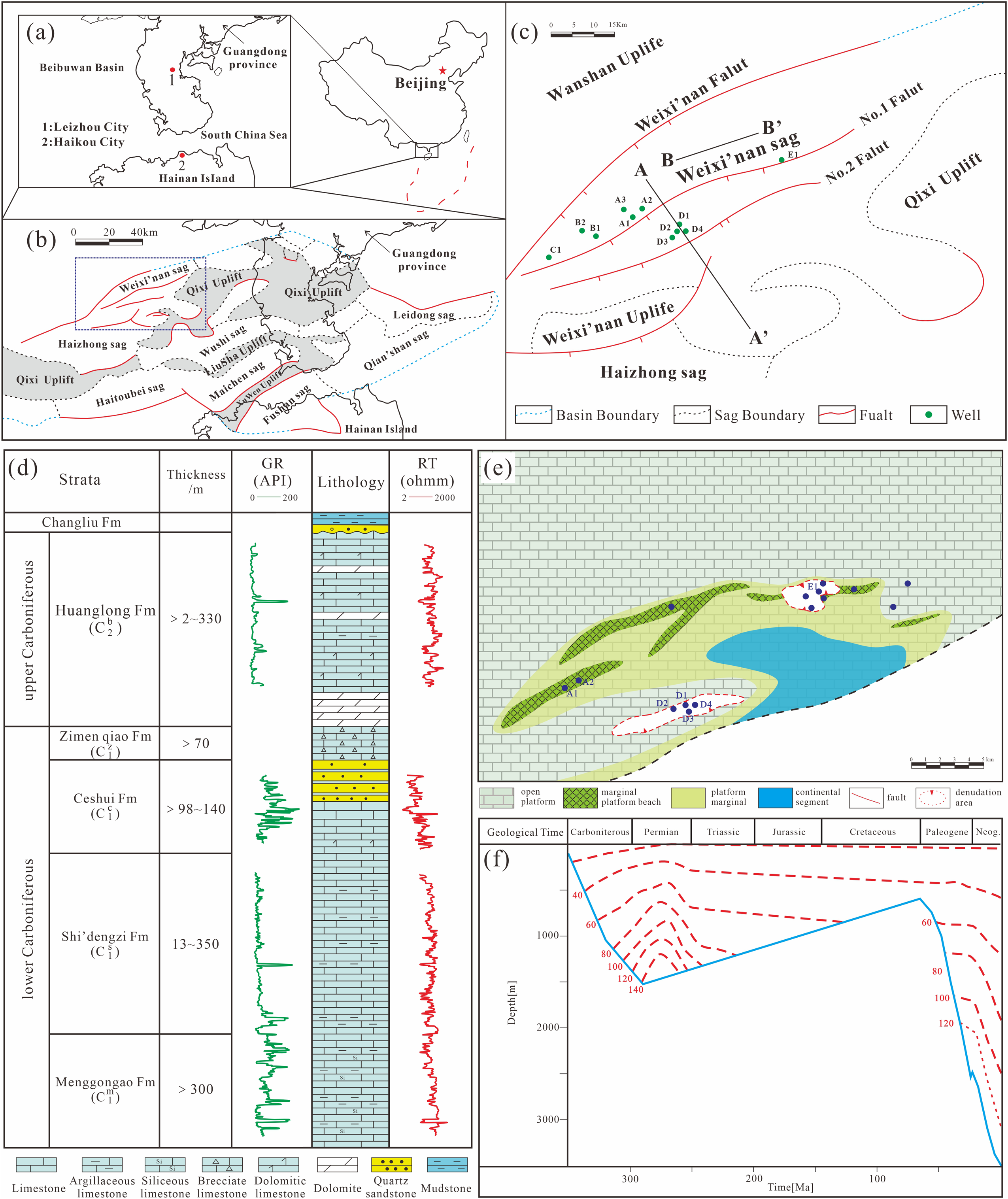
Location and geology of the study area. (a) Location of Beibuwan Basin. (b) Tectonic divisions of the Beibuwan Basin and location of the study area. (c) Tectonic divisions of the Weixi’nan Sag. (d) Generalized stratigraphy and associated reservoir intervals of Carboniferous Weixi'nan Sag. (e) Distribution of sedimentary facies in Carboniferous and cored wells in the study area. (f) Stratigraphic burial and thermal history in Weixi'nan Sag.
The carbonate-buried hill strata in the Weixi’nan Sag are similar to the Tieshan Gang area in Hepu, Guangxi, belonging to the Carboniferous system. The strata comprise the lower Carboniferous Meng’gong’ao Formation (C1m), Shi’deng’zi Formation (C1s), Ce'shui Formation (C1c), Zi’men’qiao Formation (C1z), and upper Carboniferous Huang’long formation (C2b) (Figure 1(d)). A large number of wells have confirmed that the carbonate in the basin is an acid rock basement, mainly distributed near the No. 1 fault zone to the No. 2 fault zone in the Weixi’nan Sag (Figure 1(c)), and exhibits varying degrees of oil and gas (Jiao et al., 2018; Zhao et al., 2018, 2019). The lithology of the carbonate-buried hill strata is complex, primarily comprising limestone and dolomite, followed by dolomite limestone or limestone dolomite (Figure 1(d)). Carboniferous sedimentary facies mainly include open platforms, marginal platform beaches, and platform margins (Figure 1(e)).
Affected by the Indo-China movement, the study area was uplifted and exposed during the Permian–Early Cretaceous and was again submerged during the Eocene sedimentary period, with exposure lasting up to 150 Ma (Figure 1(f)) (Jiao et al., 2018; Zhao et al., 2019). Later, the study area maintained a structural pattern of continuous fault depression and deposition until now (Jiao et al., 2018). This long-term exposed environment is suitable for developing epigenetic karst in the study area.
Samples and methods
In this study, 24 wells were analyzed comprising logging data, drilling logging data, test data analysis, and 82.45 m core samples sampled and analyzed from 12 wells. The chosen well locations in the article adhere to the principle of regional representativeness. This means that drilling was conducted in diverse geological units and features within the study area. For instance, the A1 and A2 wells were situated in karst highlands, while the B1 well, B2 well, and D1 to D4 wells were located on karst slopes. Additionally, the E1 well was positioned in the karst basin. The inclusion of these specific well locations ensured that ample data support was obtained for this study. Overall, 223 core samples were collected, and thin sections were cut for microscopic observation and lithofacies analysis. The pore type, cementation degree, and dissolution were evaluated using scanning electron microscopy. Alizarin Red-S was used to semi-stain all rock slices to distinguish between calcite and dolomite. Standard transmitted-light microscopy (plain and polarized light) was used to analyze the petrographic and diagenetic properties. To explain the mineral composition of carbonate rocks in detail and to determine the proportion of dolomite and calcite, the quantitative analysis of whole rock mineral relative quantity XRD and clay mineral relative quantity XRD was performed.
For the 24 carbonate rock samples, the carbon isotope and oxygen isotope were analyzed, and the test work was completed at the Key Laboratory of Earth Exploration and Information Technology, Ministry of Education, Chengdu University of Technology. The stable isotope measurements are expressed as ‰ with a relative error of ±0.15‰. Trace elements such as Fe and Mn were analyzed at the Exploration and Development Research Institute of the South China Sea West Petroleum Company. The test instrument used was the 2000DV with an error of 0.002%. The detection was based on the reference Y/T05-1996 ICP broad-spectrum method. The fluid inclusion test was carried out at the Geological Experiment Test Center of the Xi’an University of Petroleum, and the experimental equipment used was the LINKAM THMS600 cold and hot platform. The full operational instructions and relevant experimental principles were proposed by Liu et al. (2017).
Results
Stratigraphic hiatus and unconformity surface
It has been established that the Carboniferous period exhibits stratigraphic hiatus and unconformity contact with the overlying strata. As illustrated in Figure 2, the No. 2 tectonic belt in the study area experienced the most significant erosion and gradually weakened toward the peripheral regions. For example, well D1 loss the C2b C1z and C1c layers, well E1 was missing the C2b and C1z layers, and well C1 only loss the C2b layer (Figure 2).
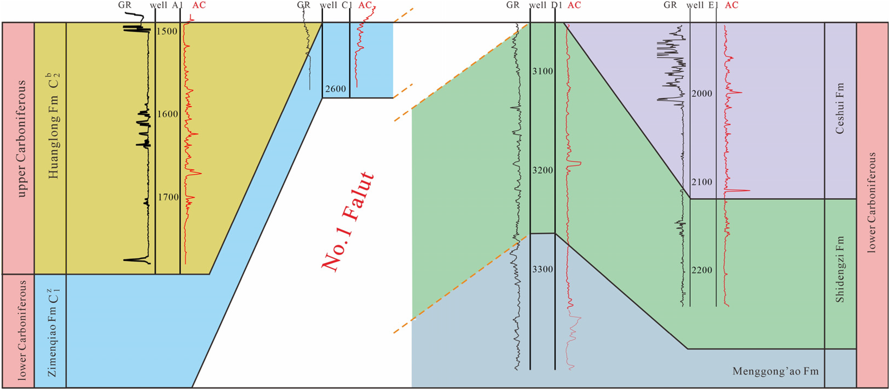
Stratigraphic correlation of the upper strata of the Carboniferous from wells A1, C1, D1, and E1, based on a nearly isochronous stratigraphic interface overlying the Carboniferous. See Figure 1(c) for well location.
Between 3 and 5 m from the top of the Carboniferous carbonates, depositional and erosional characteristics were observed to be connected to unconformity surfaces (Figure 3). The discontinuity at the top of the Carboniferous layers was identified by variations in the composition and color of the rocks. The brownish-gray gravelly sandstone at the top changed into light-gray limestone. The gravelly sandstone typically has a gravel diameter of 1–2 mm and is primarily cemented with argillaceous cementation (Figure 3(a)), found as fills in the weathered zone. Furthermore, transparent calcite clusters can also be observed 20 cm below the unconformity surface (Figure 3(c)). The vicinity of the unconformity surface is generally considered to be an erosional surface, where the reddish color appears locally due to iron oxide coating and weathering leaching (Figure 3(b)). Thin reddish paleosols were 1.5 cm thick and developed at 10–15 cm below the unconformity surfaces (Figure 3(b)).
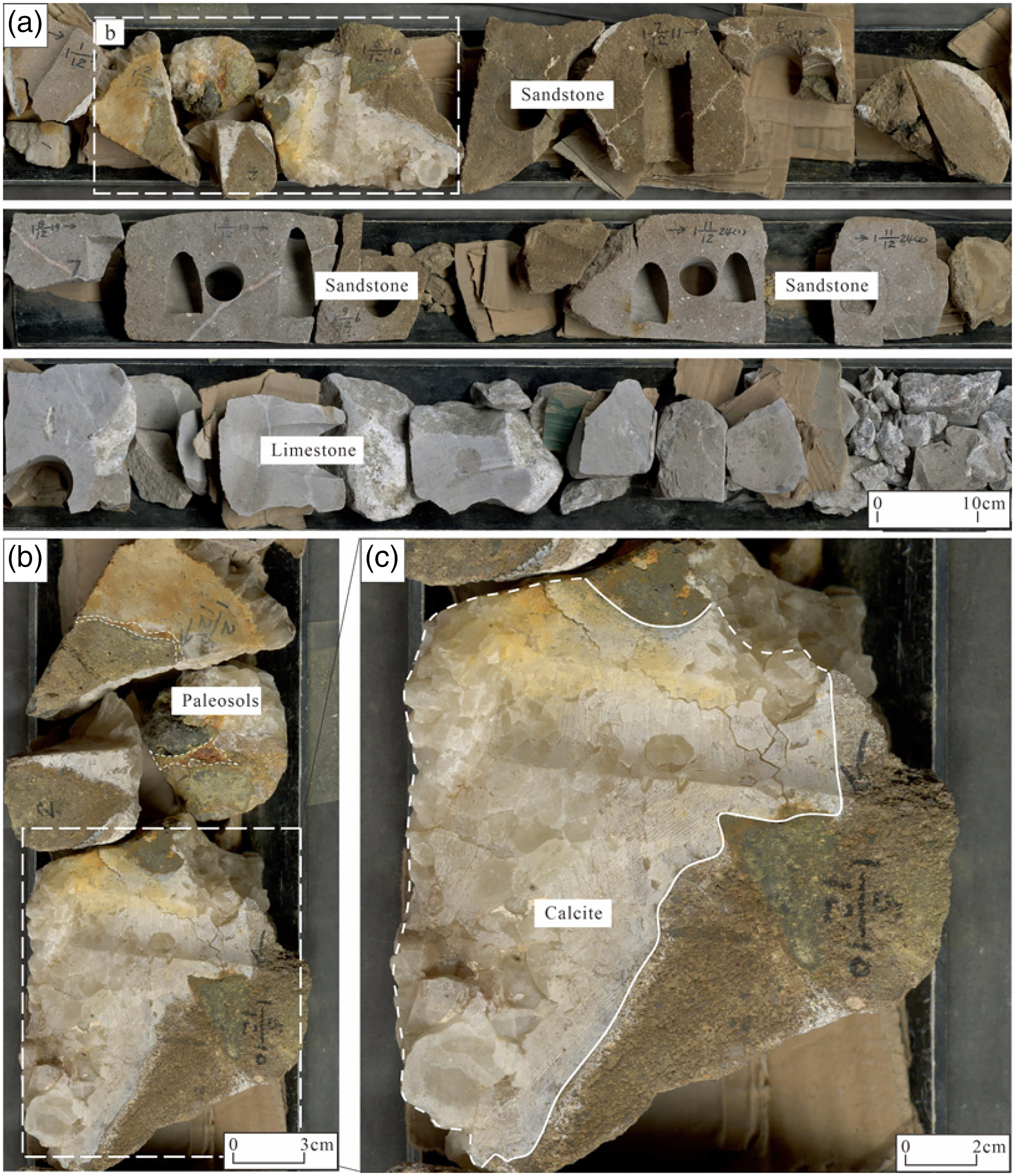
Unconformity at the top of the Carboniferous and associated pedogenic features. (a) Core characteristics near the unconformity of well A1 (1491.00–1492.98 m). (b) Associated pedogenic features (iron oxide coating and reddish color). (c) Calcite crystal clusters were shaped like horse teeth.
Drilling break and leakage
In a karst system, drilling breaks and leakage are typically considered indicators of cave formation and subsurface fractures (Feng et al., 1998; Tinker and Mruk, 1995). Among the 24 wells drilled in carbonate rocks in the study region, 10 had drilling breaks and leakage. The vertical distribution of drilling breaks and leakage exhibits certain regularity (Figure 4), with most occurrences being within 50 m of the unconformity in the vertical direction; however, the distribution is still present in the lower section. Moreover, cored wells with drilling breaks and leakage experience relatively poor core recovery. For example, the core recovery for well A3 was only 31.82% (section 1678.00 m to 1682.40 m, with a core harvested length of 1.4 m).
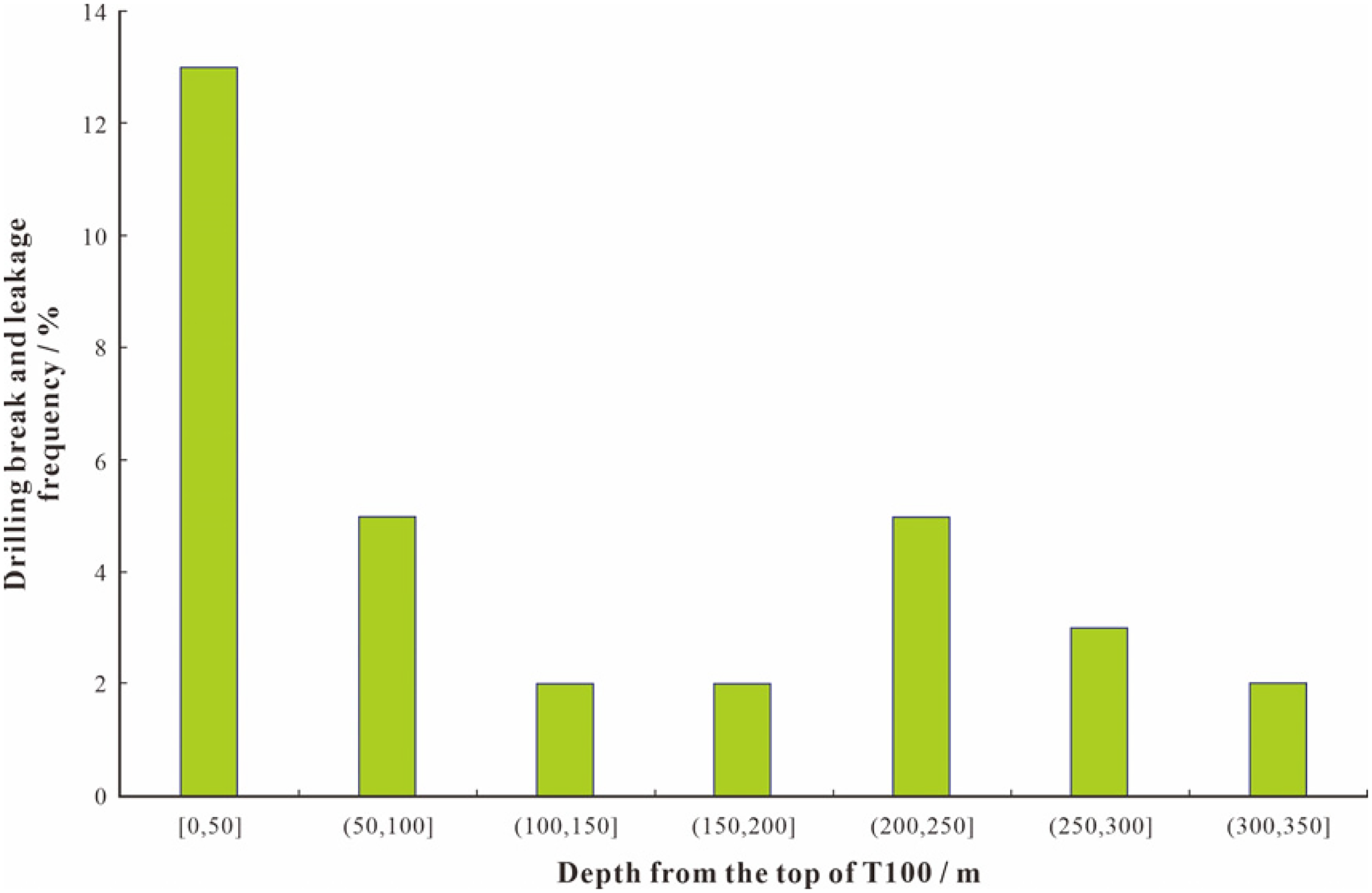
Drilling break and leakage characteristics of the various intervals at different depths in the Carboniferous in Weixi'nan Sag.
Dissolution and filling
Karst reservoirs possess significant properties, including dissolution and filling (James and Choquette, 1988). These features of karst reservoirs can be categorized into three groups based on core observation and thin section identification: (1) caves, (2) dissolution pores, and (3) dissolution fractures (as channels for flowing water) (Larson and Mylroie, 2018). Furthermore, the characteristics of dissolving and filling seem to be “facies-controlled,” frequently occurring in specific lithofacies.
Caves
The observational findings provide direct evidence of phenomena such as the dissolution and filling of caves (Huang et al., 2019). The existence of the caves is confirmed by the collapsed karst breccias and euhedral transparent calcite crystal clusters growing along the cave wall (Figure 3(c)). The cave's approximate height is 0.6–2 m, and karst breccia was observed in well C1 between 2592.71 m and 2593.38 m, with clast sizes ranging from 0.5 mm to 3 cm, medium sorting, and angular to subangular (Figure 5(a)). The cave's sediments consist mainly of micritic limestone, reddish brown to dark reddish brown, very hard, low porosity, and calcareous, with a small amount of dolomitic debris and speckled distribution of light olive-gray calcite (Figure 5(b) to (e)). Under the microscope, the fillings of the caves were also found to have dolomitic gravel and calcite gravel (Figure 5(f) to (h)), with the quartz clasts located between dolomitic gravel and calcite gravel (Figure 5(f)). Unfortunately, this phenomenon was only observed in three to four of the cored wells in the study area, and they are not ubiquitous. The poor recovery rate of coring could also be an indicator of limited cave development.
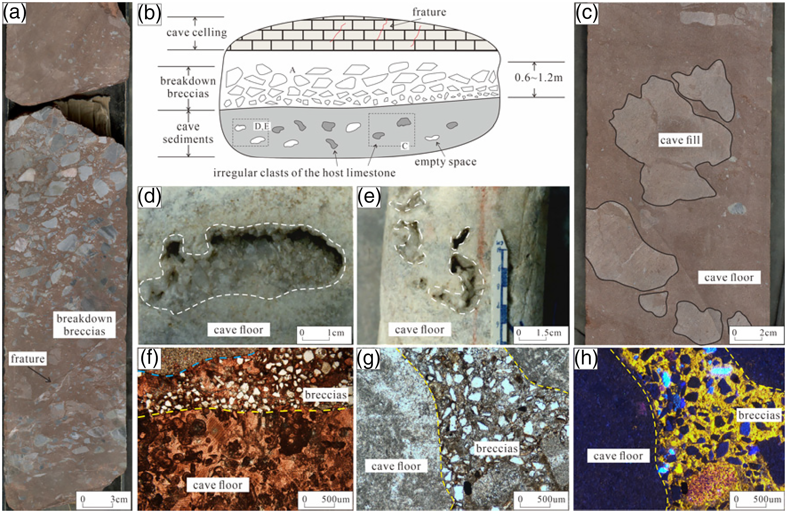
Dissolution and filling characteristics of caves in Weixi'nan Sag. (a) Typical cave in well C1 at depth from 2592.71 to 2593.38 m, with cave fills at the karst breccia (gravel sandstone). (b) Diagram of karst cave model in the study area. (c) The core of well C1 (2591.25–2591.75 m) shows the speckled distribution of calcite in the cavern. (d) Well A1 (1555.65 m) limestone calcite crystal semi-filled cave. (e) Well A1 (1555.5 m) limestone calcite crystal semi-filled cave. (f) Microscopic characteristics of carbonate breccia in well C1 (2589.8 m) cave. (g) Microscopic characteristics of carbonate breccia and cement in well C1 (2589.8 m) cavern. (h) Panel (g) features under cathodoluminescence (the cement is bright yellow).
Interpretation
The cave, discovered in well C1, is thought to have formed due to the dissolution of the horizontal hyporheic zone of the underground river (Tian et al., 2019a). The breccia debris found in the cave typically exhibits mixed in situ accumulation, with poor sorting and rounding grades. The gravel in the cave is angular to subangular in shape, with no definite directionality, indicating minimal transportation. It is hypothesized that these caves are formed through water diffusion and dissolution, providing channels for water flow.
Dissolution pores
The most representative type of macropore in the studied region is the vertical dissolution pore, which exhibits “beaded” and “continuous” characteristics (Figure 6). The study area contains three different types of pores: random distribution dissolution pores, vertical dissolution pores, and near-horizontal dissolution pores. Random distribution dissolution pores are widely distributed and can occur in any lithology in the study area, and their shape is often irregular (Figure 6(a) to (d)). Vertical dissolution pores are generally developed within micritic bioclastic limestone and sparry bioclastic limestone layers but rarely in the micrite limestone layers. Pores usually have beaded and continuous developments (Figure 6(e), (f), and (h)). A series of continuous beaded dissolution pores have a height of 0.1–0.5 m, and the pore width is ∼0.5 cm, with a relatively uniform size change (Figure 6(e), (f), and (h)). Horizontal solution pores are mainly developed in the sparry bioclastic limestone layers (Figure 6(g), (i), and (j)), with a width of ∼0.5 cm or greater. Some horizontal solution pores are filled with calcite (Figure 6(g)). Extensive horizontal dissolution is prone to collapse, resulting in breccia formation in the horizontal dissolution sections (Figure 6(i)).
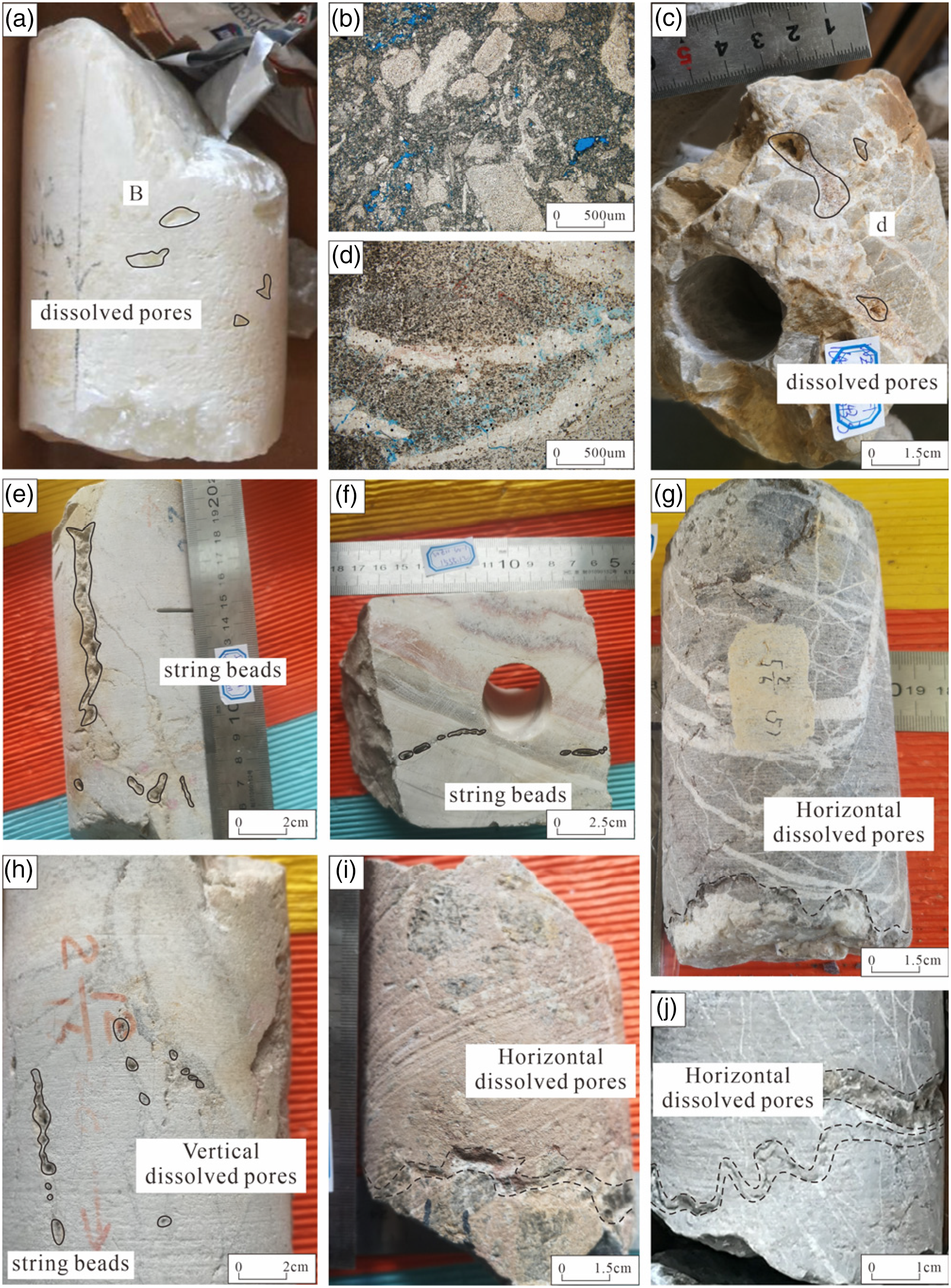
Macroscopic characteristics of dissolution and filling of dissolution pore in Weixi'nan sag. (a) Well A1 (1794.2 m), the disordered distribution of dissolution pores in calcite crystals. (b) Microscopic characteristics of dissolution pores in panel (1). (c) Well B1 (1643.3 m), dissolution pores develop in the core and are distributed irregularly. (d) Microscopic characteristics of dissolution pores in panel (c). (e) Well A1 (1552.25 m), the core shows a beaded distribution of dissolution pores. (f) Well A1 (1555.12 m), the core section shows that the dissolution pores are beaded distribution. (g) Well D1 (3296.5 m), horizontal distribution of dissolved pores in dolomitic oolitic limestone cores, similar to sponges. (h) Well A1 (1555.10 m), the core shows a beaded distribution of dissolution pores. (i) Well C1 (2590.28 m), cores show the horizontal distribution of dissolution pores. (j) Well D1 (3297.04 m), horizontal distribution of dissolution pores in dolomitic oolitic limestone cores.
The most common dissolution pores under the microscope are intergranular and intragranular dissolution pores. More specifically, intergranular dissolution pores include algal framework dissolution pores and intergranular matrix dissolution pores. The former is mostly distributed along the particle contour, and the distribution density is not concentrated (Figure 7(a)). The latter is mainly concentrated in the vicinity of soluble media, with corrosion occurring in a “large area” (Figure 7(b)). Dolomite also has intergranular dissolution pores in the study area, most of which are polygonal (Figure 7(c)), harbor-shaped (Figure 7(d)), and other irregular shapes, with diameters ranging from 28 to 200 μm. Molds filled with calcite cementation formed during the dissolution of fusulinid can also be observed (Figure 7(e)). Additionally, the cemented calcite veins have dissolution pores, with diameters ranging from 28 to 260 μm. Most of them have a bay-like shape, and the face rate is up to 1.5% (Figure 7(f)). The presence of vein-dissolution pores indicates that the late fluids not only reformed primary pores and minerals but also dissolved the epigenetic minerals.
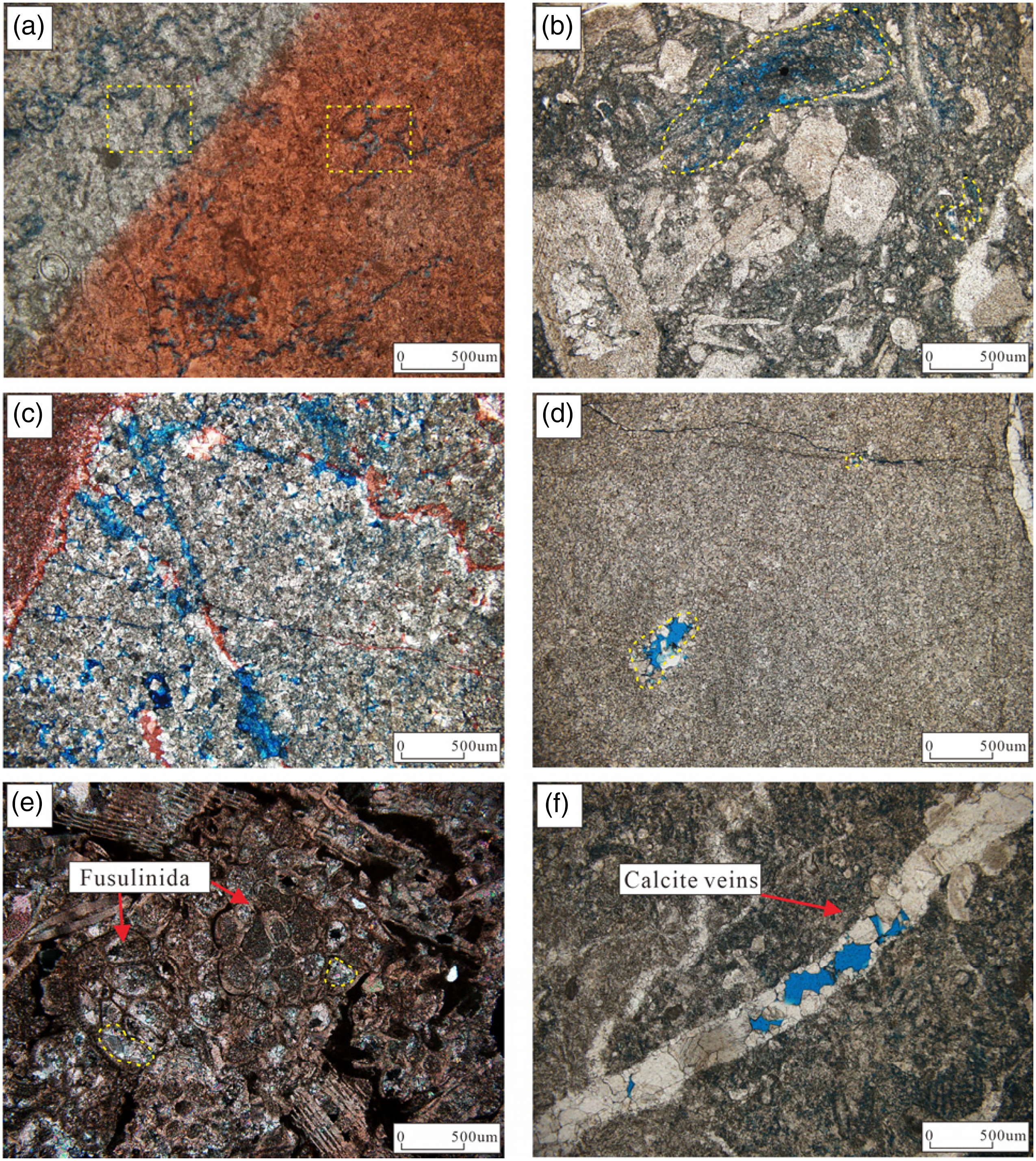
Microscopic characteristics associated with dissolution pores. (a) Well A1 (1553.15 m), intergranular dissolution pores in algal limestone. (b) Well A2 (1917.5 m), intergranular dissolution pores are developed in bioclastic micritic limestone. (c) Well A1 (1556.15 m), intercrystalline dissolution pores are developed in fine-medium crystal dolomite. (d) Well B1 (1642.26 m), intercrystalline dissolution pores are developed in powder-fine crystalline dolomite (e) Well D1 (3060.1 m), the residual molds were metasomatized, and the body cavity was selectively dissolved to form the molds, which were cemented by calcite. (f) Well A1 (1552.65 m), vein-dissolution pores are developed in dissolution fractures of micritic limestone.
Dissolution fractures
In the study area, subvertical dissolution fractures are prevalent and primarily occur in micritic bioclastic limestone and micritic limestone (Figures 8 and 9). The majority of these fractures are filled with calcite, while a small proportion contains mud or is unfilled (Figure 10). Acting as bridges between dissolution pores or caves, these narrow vertical conduits serve as channels for water flow (Figure 10(a)). Typically ranging from 5 to 15 mm in width, the subvertical dissolution fractures tend to be almost perpendicular to the bedding plane. Unfilled dissolved fractures are observed at the core, linking the upper and lower caves (Figure 10(b) to (d)). Structural activity has led to the formation of network dissolution fractures in the study area (Figure 10(c) and (e)). Additionally, dissolution processes have caused fractures to expand to between 2 and 5 cm in diameter, allowing them to act as conduits (Figure 10(f) to (g)). This phenomenon of fracture diameter enlargement is primarily observed in structural belt No. 2.
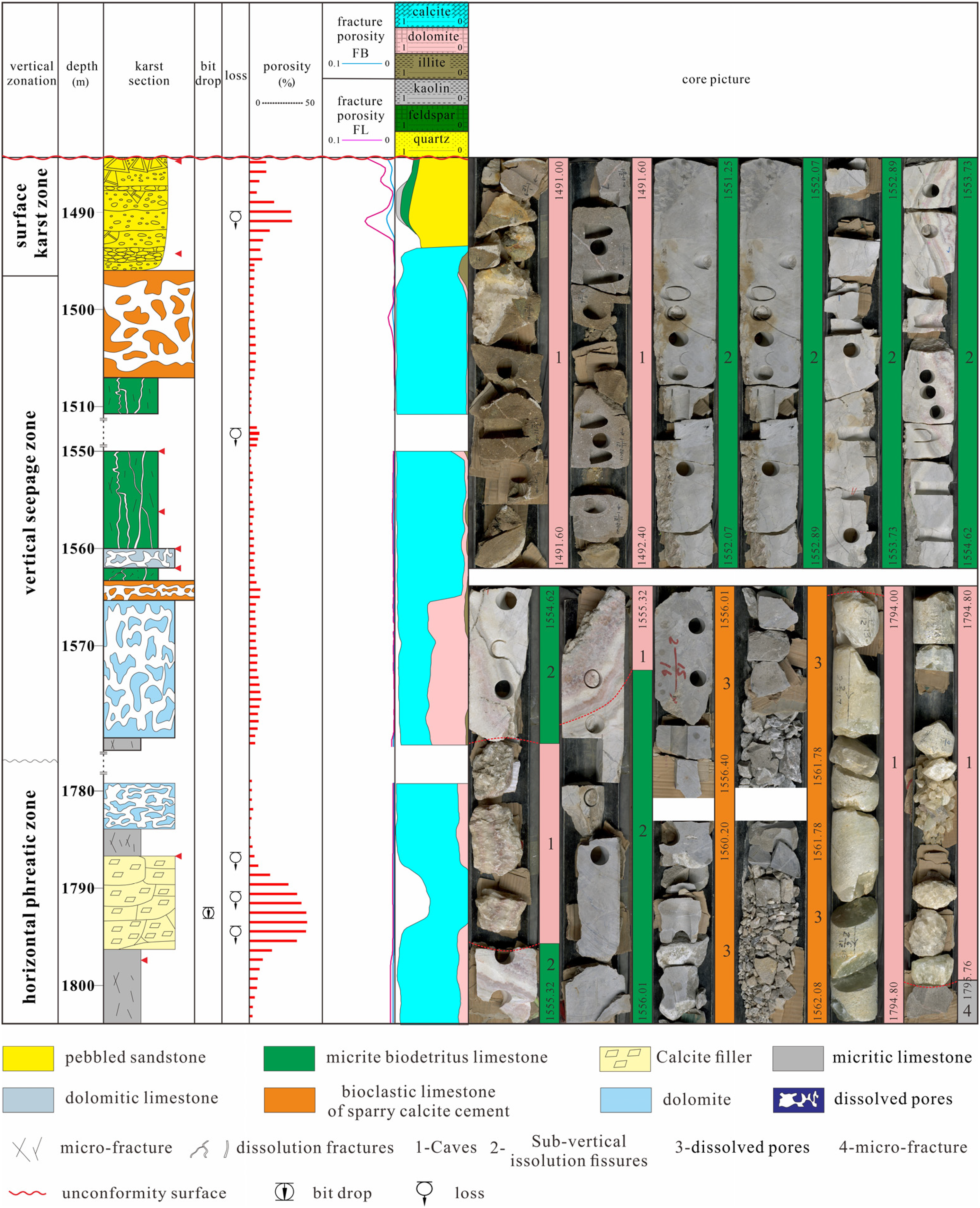
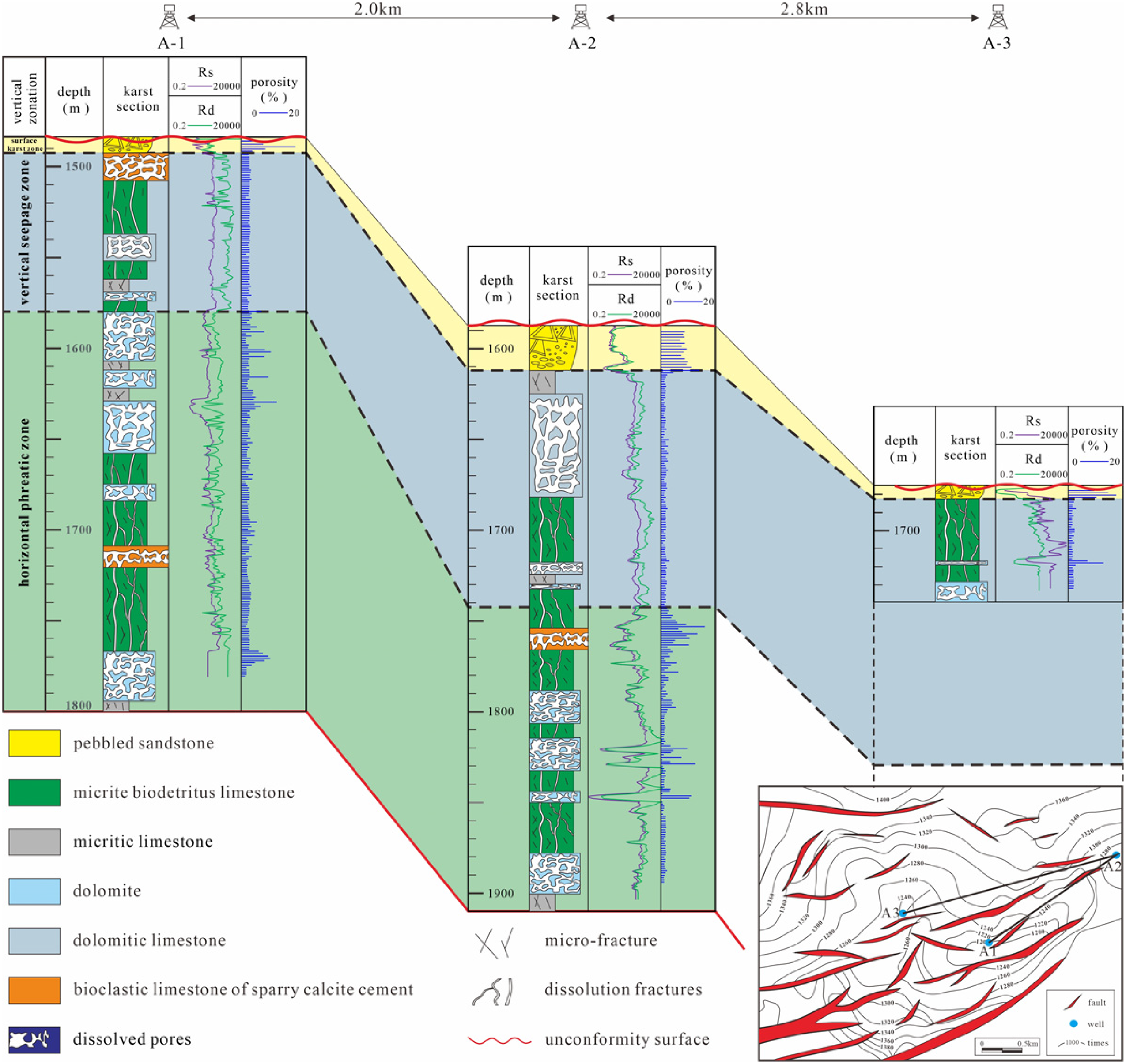
Vertical karst zonation and associated features of the Carboniferous karst in well A1 (1489–1800 m).
Vertical karst zonation and features in wells A1, A2, and A3 show correlations between dissolution features and geomorphology of the platform.
Dissolution and filling characteristics of subvertical dissolution fractures in Weixi'nan sag. (a) well A1, 1553.73–554.62 m, the core shows the development of dissolution fractures and is connected with karst caves. (b)–(d) The locally enlarged view of (a) shows obvious dissolution fractures, which can act as water flow channels. (e) Microscopic features of (b) show two intersecting fractures. (f) Well D1 3301.32–3302.32–3303.32 m, the core shows well-developed fractures, most of which are filled with calcite. (g) In the locally enlarged view of (f), after dissolution, fracture diameters can be enlarged to 2–5 cm wide. (h) The microscopic characteristics of (f). A number of dissolution cracks were developed, none of which were filled.
Interpretation
The dissolution fractures primarily consist of subvertical fractures with a specific orientation, indicating their formation within the vertical permeability zone (Xiao et al., 2016; Yang et al., 2021; Zhang et al., 2022a, 2022b). In addition to functioning as reservoir spaces, these dissolution fractures can serve as water channels. Most subvertical solution fractures connect multiple small microfractures that dissolve and connect when water flows through them. This process results in the formation of a channel through which water can flow, thus facilitating water movement to deeper levels (Mylroie et al., 2004). In carbonate reservoirs, fractured reservoirs are also highly significant, and many tight carbonate rocks hold great potential due to the development of fractures.
Cathode luminescence characteristic
Karst breccia
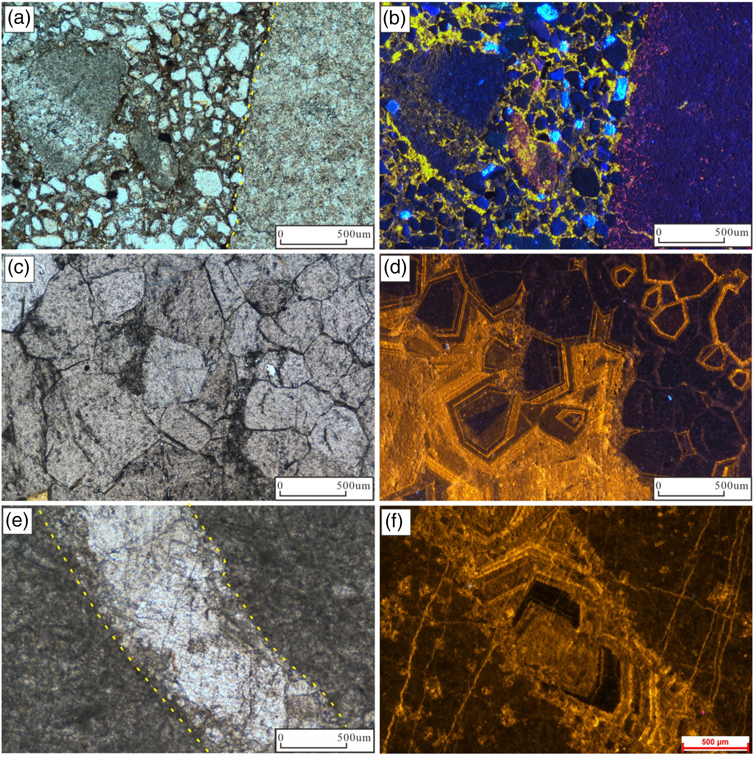
In the core, large, visibly collapsed gravel breccias fill karst caves. Under the microscope, it was discovered that the breccia, which was angular and poorly sorted, was cemented by calcite or dolomite in the area. Calcite breccia is mostly euhedral–subhedral, with clean surfaces and particle sizes ranging from 50 to 500 µm, while dolomite breccia is anhedral–subhedral, with dirty surfaces and large particle sizes generally exceeding 300 µm. The cement between the breccia is mainly composed of calcite (as shown in Figure 11(a) and (b)). Under cathodoluminescence, the matrix of calcite breccia and limestone remains dark, the dolomite breccia appears reddish purple, and the carbonate cement between the breccia emits a yellow glow (Figure 11(b)).
Cathodoluminescence characteristics of breccia and ring-zonal cathodoluminescence characteristics of cement in Weixi‘’nan Sag. (a) D1 well 2589.78 m (–), karst breccia microscopic characteristics. (b) Panel (a) characteristics under cathodoluminescence (calcite breccia does not emit light, dolomite breccia is dark red, and cement is bright yellow). (c) Well A1 1551.2 m (–), microscopic characteristics of micritic limestone. (d) Panel (c) characteristics under cathodoluminescence (Rings of different luminous intensities). (e) Well E1 1936.4 m (–), Microscopic characteristics of micritic limestone, fractures filled with calcite. (f) Panel (e) characteristics under cathodoluminescence (rings of different luminous intensities).
Zoning texture
The calcite cement observed in the study area primarily comprises coarse-grained, bright luminescent calcite. These cements are predominantly found within dissolution pores, dissolution fractures, and fractures located along the side of the pore wall. The crystals exhibit euhedral morphology, with diameters reaching up to 500 μm (Figure 11(d) and (e)), and often exhibit distinct zoning textures with three to four different intensities. The zonal thicknesses of calcite crystals vary from 50 to 100 μm (Figure 11(d) to (i)). All crystals exhibit rhombohedral euhedral outlines, although some have been deformed due to competition with surrounding crystals for growth space (Figure 5(f) and (g)). Additionally, luminescence intensity varies during different periods of cementation (Figure 5(h)).
Geochemistry
Fe、Mn trace element
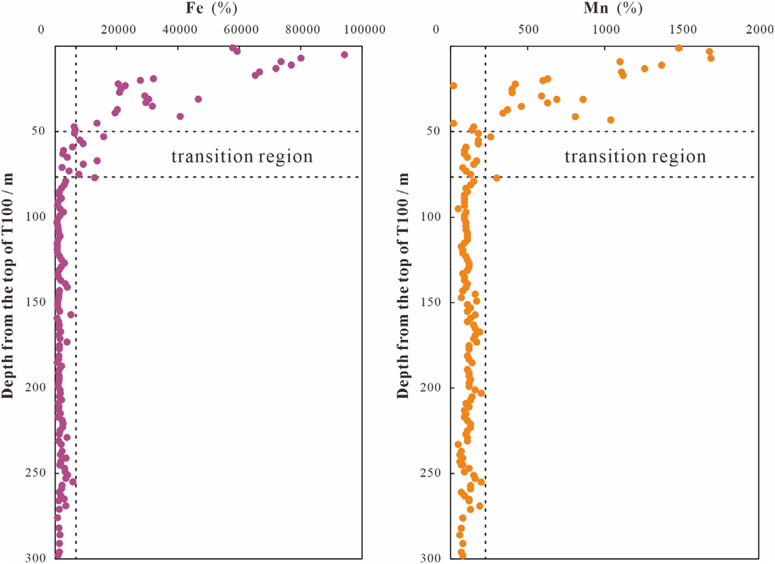
The Fe and Mn contents in well E1 vary with the unconformity depth, as illustrated in Figure 12. As the depth increases below the unconformity surface, the contents of Fe and Mn gradually decrease. The Fe and Mn contents are divided vertically into three regions: a high-value area of 0–50 m, a transition area of 50–75 m, and a low-value area of more than 75 m. At ∼50–75 m, the Fe and Mn contents in the study area decreased rapidly. Specifically, the average Fe content decreased from 4086 × 10−6 to 2277 × 10−6 and the average Mn content decreased from 826 × 10−6 to 109 × 10−6 (Figure 12). They remained relatively stable afterward.
Longitudinal variation characteristics of Fe and Mn elements in well E1 in Weixi'nan sag.
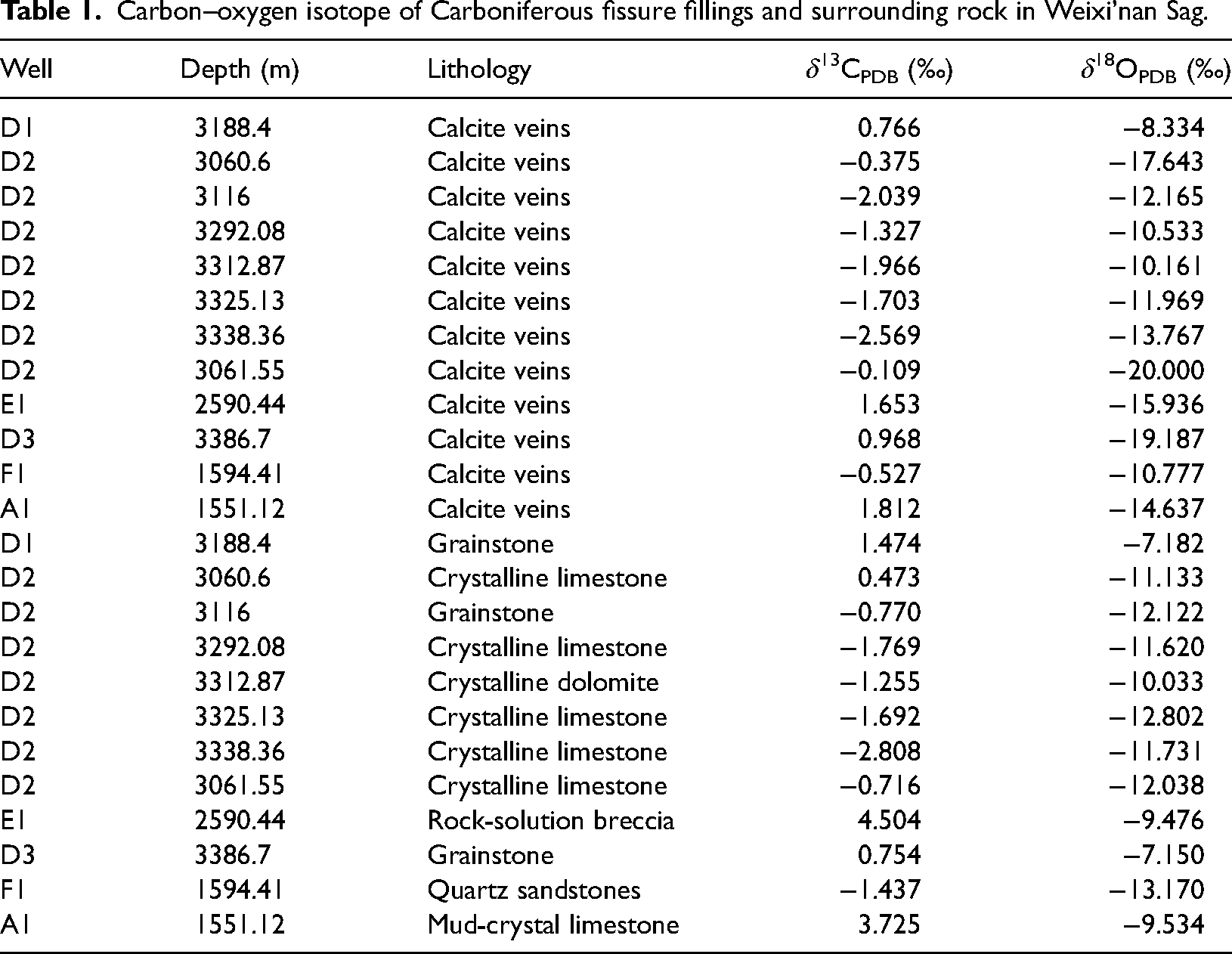
Carbon and oxygen isotopes
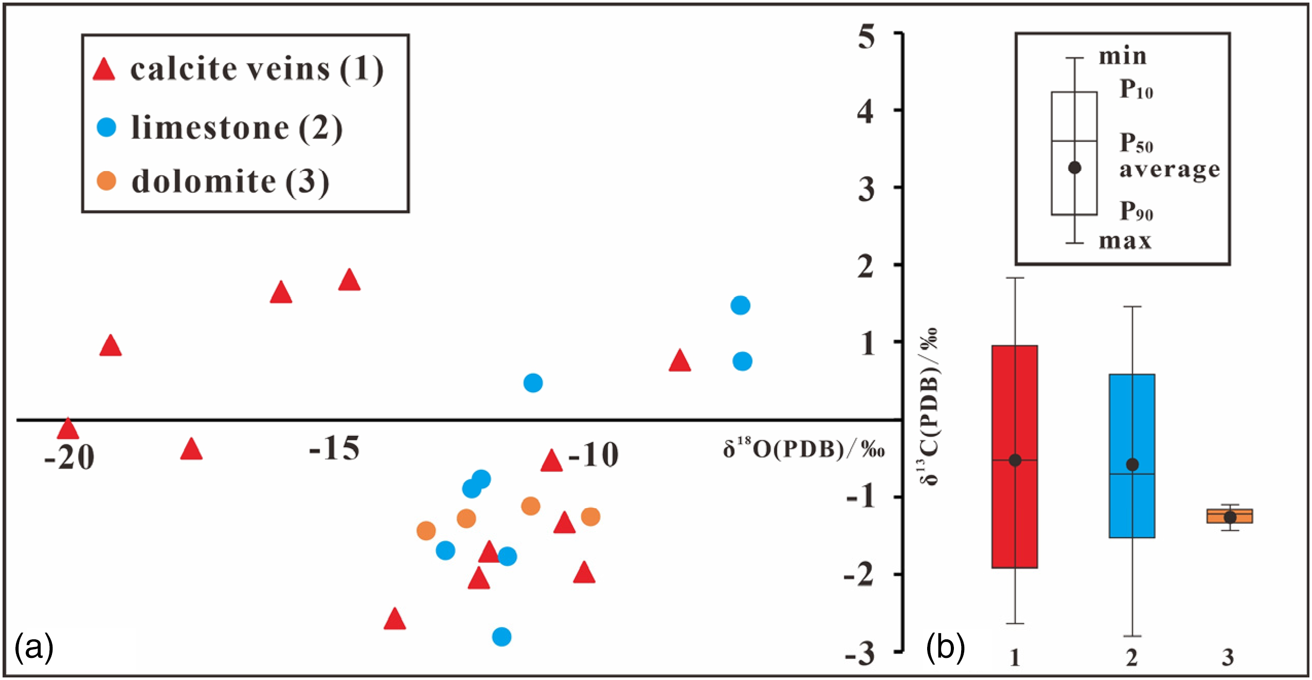
In this study, various carbonate rocks and their cement were tested and analyzed. The obtained results are presented in Table 1, and the cross-plot of 18O versus 13C values displayed no discernible relationship between them, as illustrated in Figure 13. The carbon and oxygen isotopes detected in the calcite veins of carbonate rocks varied significantly from those found in the surrounding rocks. The samples of calcite cement had 13C values that ranged from −2.569‰ to −1.812‰, with an average value of −0.451‰, while the 18O values ranged from −20.000‰ to −8.334‰, with an average of −13.759‰, as shown in Figure 13. The limestone samples showed 13C values ranging from −2.808‰ to 1.474‰, with an average value of −0.600‰, while the 18O values ranged from −13.170‰ to −7.150‰, with an average of −10.768‰, as shown in Figure 13. Furthermore, the dolomite samples had 13C values ranging from −1.692‰ to −1.255‰, with an average value of −1.423‰, and the 18O values ranged from −12.802‰ to −10.033‰, with an average of −11.509‰, as depicted in Figure 13.
Carbon–oxygen isotope intersection map of Carboniferous fissure fillings and surrounding rock in Weixi’nan Sag.
Carbon–oxygen isotope of Carboniferous fissure fillings and surrounding rock in Weixi’nan Sag.
Homogenization temperatures of inclusions
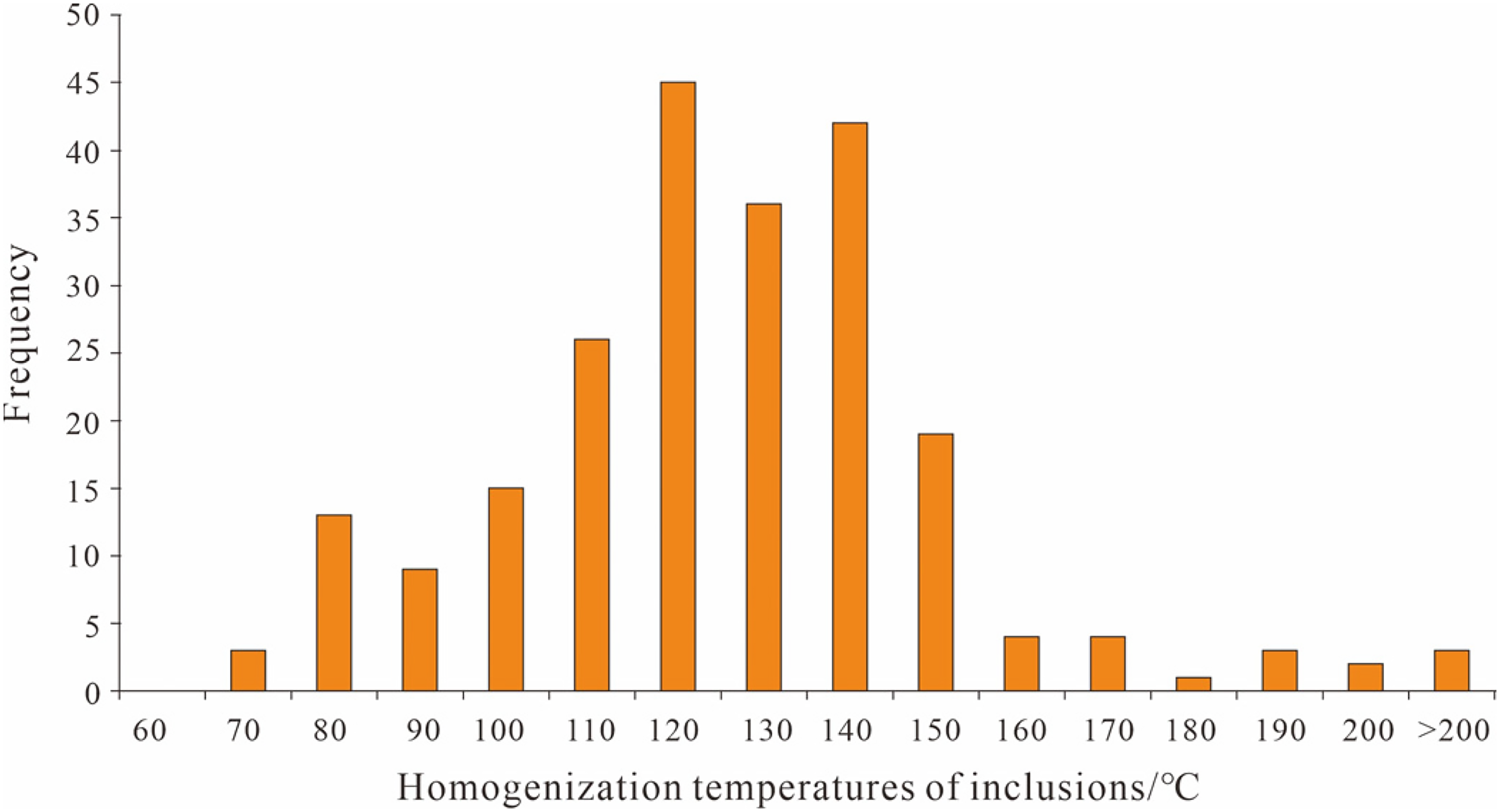
Liquid-vapor two-phase fluid inclusion assemblages were discovered in calcite veins within carbonate fractures, and homogenization temperatures are roughly divided into four intervals: <90°C, 90°C–120°C, 120°C–150°C, and >150°C, among which 110°C–120°C and 130°C–140°C were most abundant (Figure 14).
Distribution of homogenization temperatures in fluid inclusions within calcite fillings from the Carboniferous reservoir.
Vertical and lateral karst features
Many scholars have discovered that a typical karst profile has vertical zonality, influenced by meteoric water (Esteban and Klappa, 1983; Huang, 2010; James and Choquette, 1988; Longman, 1980). By combining the development law of carbonate rocks with the identification of different karst reservoirs and their filling characteristics, the karst profile in the study area can be divided into three zones: the surface karst zone, the vertical seepage zone, and the horizontal phreatic zone.
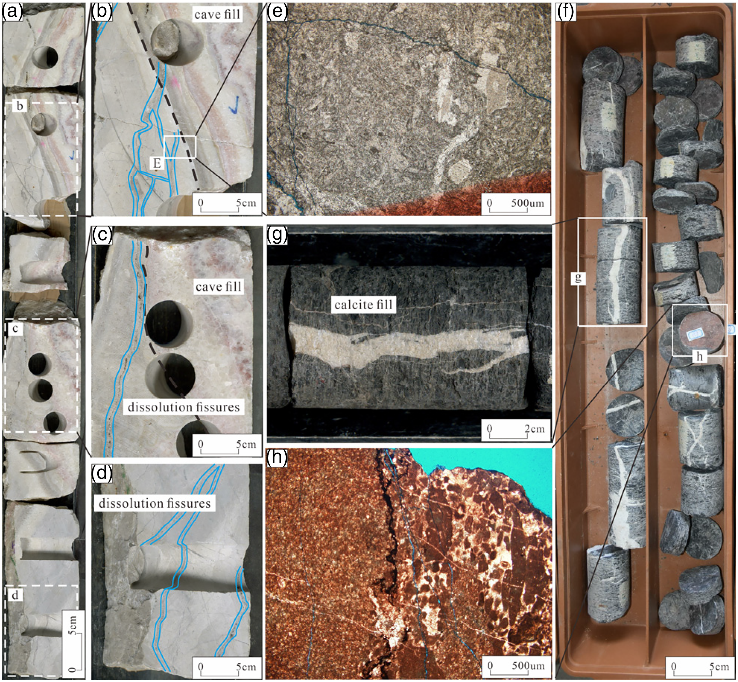
The buried hill A, which has the most cored data, provides better insight into the vertical characteristics and lateral variations. The surface karst zone was observed in layers 5 m below the unconformity (Figure 8). The dissolution in this zone is strong and caves are easily formed, which can then be filled with debris. Gravelly sandstone, accompanied by calcite veins (Figure 8, 1491.2 m), is filled 1.4 m below the unconformity surface. The logging and fracture porosities of these intervals are higher than that of the normal section, and drilling breaks and leakage often occur (Figure 8).
The vertical vadose zone is identified at 5–150 m below the unconformity, and the subvertical dissolved fractures, dissolution pores, and caves mainly occur in this section (Figure 8). The karst is highly developed in the core, and vertical fractures and caves are interconnected throughout the core (Figure 8, 1551.25–1554.40 m), indicating prolonged vertical water circulation. Most dissolution fractures and caves are vertically distributed, and the microfractures are reticulated (Figure 8, 1552.89–1554.62 m) and filled with calcite. Obvious crude oil can be found in the fractures (Figure 15(a)). Moreover, transparent calcite crystal families grow along the cave walls (Figure 8, 1555.32–1554.52 m), which later fills most of the cave space. The thin sections were identified as micritic bioclastic algal clastic limestone from 1551.25 to 1555.17 m, where the organisms were mainly green algae fragments, with foraminifera and echinodermata occasionally observed (Figure 15(b) and (c)). From 1555.77 to 1556.40 m, there are dolomites (Figure 15(d)) with strong dissolution, high porosity, and permeability.
Characteristics of dissolution in different karst zones in Weixi'nan sag. (a) Original intact core 1551.70–1551.90 m from well A1, oil-bearing in limestone fractures (brown–yellow). (b) The microscopic characteristics of well A1 at 1551.2 m show the presence of foraminifera and bio-disturbance structure. (c) The microscopic features of well A1 at 1553.15 m show that the echinoderms were dissolved and filled with calcite. (d) Well A1 shows the strong dissolution of fine-medium crystal dolomite at 1556.15 m. (e) The microscopic features of well A2 at 1917.5 m show that e6chinoderms were dissolved and then filled with calcite, preserving the original bioclastic profile.
The horizontal phreatic zone is identified at 150–260 m below the unconformity (Figure 8), where the porosity is high, and drilling breaks and leakage are common (Figure 5). The dissolution pores and fractures are mostly horizontal and distributed along the layer. Horizontal dissolution pores are continuously distributed, mostly forming karst caves that later collapse, with cave collapse deposits such as gravel sandstone being commonly observed and grain size gradually thinning from top to bottom (Figure 4(a)). Fe or mud is observed between the gravels. Typical cave fillers can be seen in the core, namely transparent calcite veins (Figure 8, 1794.05–1795.66 m), with good crystallization and good joints belonging to the rhombic system with a smooth crystal face. Gray marl with a powder-fine crystal structure can be observed at the bottom (Figure 8, 1795.66–1795.76 m), which is dense, hard, and reacts strongly with hydrochloric acid. Additionally, echinodermata can be seen under the microscope (Figure 15(e)).
The lithology of the same buried hill is found to have good correspondence, that is, it is comparable. Moreover, in the vertical direction, a few tight sections with low porosity hinder the connection of different karst zones or between different karst zones (Figure 9). Laterally, karst zones are comparable within the range of buried hills. Reservoirs in the karst zones of different wells are similar in thickness and porosity (Figure 9). The above shows that there is a certain lateral extension of the karst within the same buried hill (≥3 km, where the distance between wells A2 and A3 is 3 km).
Discussion
Karst environment
The buried hill in the research area has undergone several stages, including the syngenetic stage, shallow burial karst, epigenetic karst due to weathering and leaching during the uplifting stage, and differential uplift and transformation karst of faults in the deep burial stage (Xiao et al., 2019). To better understand the formation of karst pores in the research region, it is crucial to comprehend the time, place, and cause of karstification as well as the primary governing elements in the evolution process of karstification (Esteban and Wilson, 1993). By analyzing the core, thin section, seismic, and geochemical characteristics of carbonate karst in the study area, it is evident that there exist karst environments such as syngenetic karst, epigenetic karst, and buried karst (Scholle et al., 1983).
Syngenetic karst
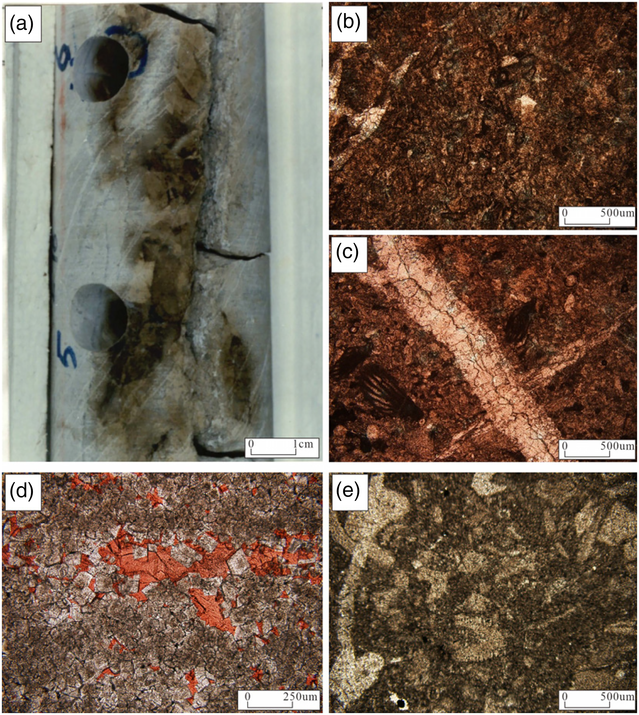
Syngenetic karst refers to dissolution dominated by selective fabric dissolution caused mainly by temporary exposure to the surface due to changes in sea level and sedimentation rates after deposition and leaching by atmospheric fresh water (James and Choquette, 1988). Although carbonate rock diagenesis occurs throughout the burial history, the primary pore reformation mainly occurs during the early diagenesis stage when sediments form and are exposed to atmospheric fresh water (Woodhead et al., 2022). In recent years, more attention has been paid to the effect of syngenetic karst on carbonate pore formation (Godet et al., 2016; Moore and Wade, 2013; Scholle and Ulmer-Scholle, 2003). The typical characteristics of syngenetic karst include selective fabric dissolution when atmospheric freshwater permeates through particles, such as molds and intragranular dissolution pores, and some typical marine cement such as micritization and fibrous calcite cement (Figure 16(a)). We believe that syngenetic karst occurred in the studied area because this study has identified all of these characteristic properties.
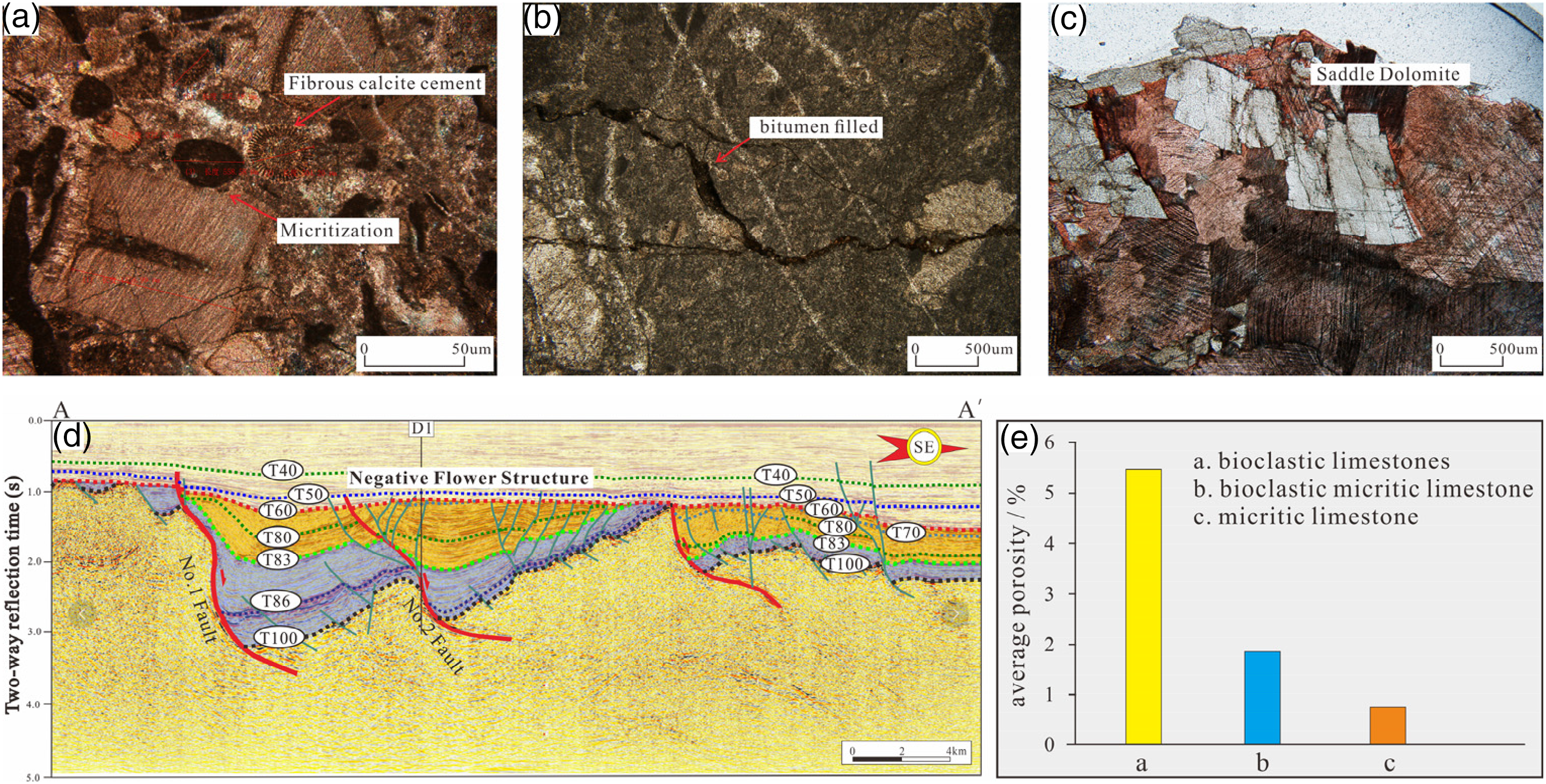
(a) Well D2 (3386.7 m) micritization in carbonate rocks. (b) The sutures in the E1 (1918.5 m) micritic limestone are filled with bitumen, cracked by compaction during burial, and cut by suture lines generated by pressure dissolution, followed by hydrocarbon charging. (c) Well D1 (3296.97 m (—)) shows saddle dolomite with wavy extinction under the microscope, which is of hydrothermal origin. (d) The comprehensive interpretation of the ILN4259 line in Weixi’nan Sag shows the existence of a negative flower-like structure near D buried hill. (e) Statistics of porosity characteristics of different lithology in Weixi’nan sag.
Selective fabric dissolution is often observed in bioclastic limestone and calcite grains in cores and under a microscope, forming molds with original grain or grain shapes preserved (Figure 7(e)). The molds are geological signs of syngenetic karstification, which generally appears in isolation, with poor connectivity and permeability, and many structures of fusulinids filled with calcite cement. The dissolution of bioclast components to form molds depends on the formation time of the bioclast structure. Generally, the initial deposition components are more easily formed into molds. However, densely drilled molds eventually connect into pieces, forming micrite sets or even the entire micrite grain (Figure 16(a)) (Huang, 2010).
Geochemical characteristics also prove the existence of syngenetic karst. The oxygen and carbon isotopes of carbonate rocks and cement indicate that they were formed by the same sedimentary fluid (Xiao et al., 2019), namely Carboniferous seawater. In the syngenetic karst environment of limestone and cement in the study area, the 18O ranges from −7.150‰ to −8.334‰ and 13C ranges from 0.754‰ to 1.474‰ (Figure 13). Generally, the 18O of strongly altered carbonate rocks is <−10‰. Therefore, the oxygen–carbon isotope here can be used as a primary (i.e. the original sedimentary) oxygen–carbon isotope value of limestone. The Carboniferous carbonate in the Tarim Basin (Zhu et al., 2002) and the East Sichuan region with similar characteristics (Wang et al., 2011) can represent the reference components of Carboniferous seawater (Derry et al., 1992; Huang, 2010; Qing and Veizer, 1994; Wen et al., 2014; Williams et al., 2015). The average Z values [Z = 2.048 (13CPDB + 50) + 0.498 (18OPDB + 50), and Z value can be used to distinguish marine and terrestrial environments. When Z > 120, it is the marine environment (Keith and Weber, 1964)] of the carbonate rocks and calcite cement are 126.01 and 124.72, respectively. Both of these values exceed the marine environment threshold of 120 (Godet et al., 2016; Keith and Weber, 1964), indicating that the carbonate rocks retain some of the characteristics of their original seawater. Additionally, the Z value of the cement indicates the occurrence of a syngenetic karst environment in the study area.
Epigenetic karst
Supergene karst refers to the uplifting of deposited carbonate rocks to the near surface, mainly under the influence of atmospheric infiltration water and shallow groundwater (Bao et al., 2006). The important geological processes in carbonate rocks include dissolution, filling, metasomatism, as well as some secondary enrichment and mineralization (Huang, 2010).
The carbonate rocks in the study area were deposited on the open platform and platform margin and accumulated faster than the continental segment. The sedimentary strata were thicker, forming submarine geomorphic highlands, which provided favorable topographic conditions for epigenetic karst (Jiao et al., 2018). At the end of the Permian–Middle Triassic, under the influence of the Indo-China movement, the entire area was uplifted and subjected to weathering, leaching, and denudation for up to 150 Ma (Jiao et al., 2018). The consolidated carbonate rocks entered the near-surface environment and were dissolved by atmospheric fresh water, resulting in epigenetic karst (Jiao et al., 2018).
Carbon and oxygen isotopes are important indicators to evaluate the existence of epigenetic karst and have been extensively implemented in various basins (Lohmann, 1988; Moore and Wade, 2013; Wen et al., 2014). In areas where epigenetic karst is developed, carbon isotopes often show a serious negative deviation (Figure 13). The 13C and 18O values in the study area are negative deviations, with 13C values <0 and 18O values ranging from −2.56‰ to −0.52‰. This relates to the open diagenetic environment after tectonic uplift and light 12C and 16O atmospheric water leaching. The average Z values of carbonate and calcite veins are 118.30 and 118.08, respectively, which is significantly <120, indicating a significant influence of atmospheric precipitation and long-term leaching (Keith and Weber, 1964). In this study, the oxygen and carbon isotope values and Z values of cave fillers also indicate atmospheric precipitation. All wells in the study area exhibit response characteristics, the most classical karst process.
The features of cathodoluminescence also indicate the development of typical epigenetic karst in the study area. Breccias in the study area are formed in a weak oxidation–reduction diagenetic environment and have the characteristics of low Mn. However, inter-breccia cement is the product of the near-surface atmospheric freshwater environment and has high Mn characteristics. Under cathodoluminescence, karst breccia and the matrix of limestone do not emit light, dolomite breccia is red–purple, and the carbonate cement between the breccia is yellow (Figure 11(b)). Due to the strong impact of the role of atmospheric fresh water, the later-filled calcite cement showed an orange cathodoluminescence zone (Figure 11(d) and (f)). Additionally, the approximate depth of the paleokarst can be judged by the distance between the content of Fe and Mn in carbonate rocks near the unconformity and the unconformity. The iron and manganese contents in the study area decreased rapidly at ∼50–75 m (Figure 12); therefore, it can be considered that the effective range of paleokarstification is between 50 and 75 m.
Epigenetic karst exhibits high karst intensity and widespread distribution, which can be attributed to the regional stratigraphic hiatus (Huang, 2010). Based on the available data on stratum thickness in the study area, the No. 1 structural belt consists of upper Carboniferous C2b, lower Carboniferous C1z, C1c, and C1s. The thicknesses of C2b and C1z are 318 and 66 m, respectively, but have been impacted by denudation. The maximum thicknesses of C1c and C1s are 216 and 250 m, respectively, close to the maximum original stratum thickness in the study area. Conversely, the No. 2 structural belt comprises lower Carboniferous C1S and C1m, with a maximum thickness of C1 m at 302.5 m. The Indo-China movement's tectonic uplift caused the absence of strata in the C1c, C1z, C1s, and the entire upper series in the No. 2 structural belt. Additionally, it resulted in various degrees of strata absence in different wells in the No. 1 structural belt, indicating significant impacts of epigenetic karst on the study area.
Medium-deep buried karst
The buried karst environment is characterized as one with the longest diagenetic process of carbonate rocks. It is also considered the most controversial karst environment due to its limited research (Ning et al., 2022; Sun et al., 2023; Tian et al., 2019a, 2019b). The burial karst environment is generally not directly influenced by atmospheric freshwater or seawater. The rocks in this environment have low porosity, poor permeability, and low fluid velocity, creating an inactive diagenetic environment.
The fault is extensively developed in the study area, allowing water to enter the basement through the faults. The fluid will permeate horizontally through the carbonate rocks with specific permeability, causing dissolution in the matrix and existing pores/fractures of the carbonate rocks (Giles and De Boer, 1989). Additionally, the overlying source rock layer's maturation generates organic acids, CO2, and H2S, penetrating the carbonate strata along the fault, disrupting the acid–base saturation equilibrium in the middle-deep buried environment, and causing dissolution. The presence of bitumen (Figure 16(b)) in carbonate fractures indicates a late karst formation, also known as buried karst.
Since 18O is sensitive to temperature, high temperature can result in a significantly negative value of 18O due to the fractionation effect. In the study area, some carbonate and calcite vein 18O values were <−17.6‰, indicating middle-deep burial (2500–3500 m) or deep hydrothermal fluids entering the carbonate through faults. Additionally, the fluid inclusion temperature in calcite veins reflects multi-stage cement formation, indicating karst conditions under different environments and burial depths. Some inclusion homogenization temperatures are higher than 120°C or even 150°C (Figure 14), suggesting that the study area is a middle-deep buried karst environment with a burial depth of over 3000 m (Figure 1(f)).
Hydrothermal environment
Saddle dolomites were discovered within the study area (Figure 16(c)), indicating that carbonate rocks had undergone hydrothermal activity during burial (Radke and Mathis, 1980). The inclusions’ homogenization temperatures were above 150°C or even 200°C (Figure 14), significantly higher than those of the carbonate rock strata (Figure 1(f)). This finding reflects deep, high-temperature hydrothermal activity in the study area. Hydrothermal dolomite reservoirs have been found in various parts of the world, such as the Lima–Indiana and Albion–Scorpion Ordovician dolomite reservoirs in the northeastern United States (Wendte et al., 2006), the Jean Marie Formation of Devonian in western Canada (Smart et al., 2006), and the Leikoupo and Dengying formations in the Sichuan Basin, China (Li et al., 2020). Numerous studies have shown that large-scale thermal fluid migration and related geological processes are associated with faulting, with a certain preference for the relative strike-slip tectonic setting (Tang et al., 2019). In the study area, the No. 2 faults developed an obvious strike-slip fault with a negative flower-like structure on the T83 interface (Figure 16(d)). This series of faults caused internal fractures in the strata, facilitating the flow of thermal fluids and extensive metasomatic dolomitization.
Facies-controlled features
Based on the above characterization, combined with geology (core observation and thin section identification) and statistical characteristics (porosity), it is found that the karst in the study area exhibits a significant feature known as “facies-controlled” features, which is controlled by the primary lithofacies (Figures 8 and 9) (Vacher and Mylroie, 2002).
A large number of non-selective dissolution spaces, such as caves, bead-like dissolution pores, and subvertical dissolution fractures, are observed in bioclastic limestones, as shown by core and thin section characteristics (Figures 6, 7, and 10). Bead-like dissolution pores and subvertical dissolution fractures are typical markers of vertical permeability karst zones. However, these characteristics are not found in micritic limestone in the study area, indicating that the karst is facies controlled. Except for the molds formed by the selective dissolution of syngenetic karst (Figure 7(e)), only small-scale dissolution fractures and spot-like dissolution pores are seen in micritic limestone, primarily due to the late structure of microfractures caused by the influence of water flow, forming in a relatively late period. Simultaneously, according to the statistical characteristics (Figure 16(e)), the average porosity of bioclastic limestone in the study area is 5.44%, the average porosity of bioclastic micritic limestone is 1.87%, and the average porosity of bioclastic micritic limestone is 0.72%. These values also indicate facies-controlled characteristics.
The facies-controlled characteristics are also evident in large indicative karst and fracture caves. First, the data of the drilling breaks and leakage section show that the height of the cave is limited, generally ranging from 0.5 to 2 m, which may be related to the thickness of the single shoal of the bioclast shoal and the filling in the karst process (Xiao et al., 2016). Second, most of the drilling breaks and leakage sections are at depths 250 m below the unconformity surface (Figure 5), roughly consistent with the Carboniferous shoal development layer (Zhang et al., 2022a, 2022b).
Therefore, the macro and micro data of drilling, logging, core, and thin sections indicate the facies controlling characteristics of the Carboniferous carbonate karst. Carbonate karst reservoirs at home and abroad, such as the Caspian Basin in Kazakhstan (Zhou and Ma, 2010), Abadan Plain in southwest Iran (Sabouhi et al., 2022), and Qaidam Basin (Liu et al., 2021) and Sichuan Basin in China (Yang et al., 2021) all exhibit facies-controlled characteristics.
Formation mechanism and model of karst
At the end of Carboniferous deposition, the carbonate rocks in the study area underwent uplift and exposure due to the Indo-China movement, followed by weathering, leaching, and denudation for up to 150 Ma (Figure 1(f)) (Jiao et al., 2018). Therefore, the epigenetic karst of the Carboniferous system mainly occurs under regional unconformity. Considering the relationship between the geological background and karst characteristics, we established a model to explain karst formation in the study area (Figure 17).
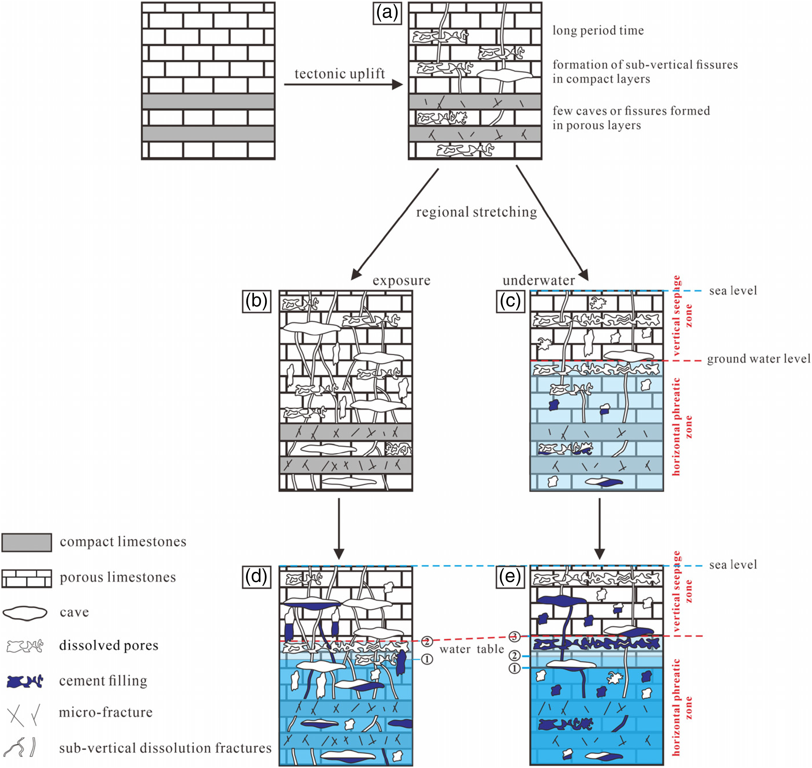
Model of macro-porosity development in the Carboniferous in Weixi'nan sag.
Due to the tectonic uplift of the early Permian, most of the carbonate rocks were exposed for a considerable amount of time, and the entire area was subjected to denudation (Figure 1(f)) (Jiao et al., 2018). Limestone dissolves when exposed to vadose water and atmospheric fresh water. As a result, microfractures formed in compact limestones, and small caves and near-vertical dissolution pores were formed in the porous limestones (Figure 18(a)).
Schematic model showing the development of facies-controlled in the Carboniferous karst.
During the Late Cretaceous to Paleocene, the Weixi’nan Fault began to reverse and slip back and accepted the deposition of the alluvial fan facies with regional northwest–southeast stretching (Figure 1(f)) (Jiao et al., 2018). During this period, buried hill C was submerged underwater. Some fractures in compact limestones were further enlarged to form small catheters (Figure 18(c)). The layers near sea level were further dissolved by seepage water, forming more dissolution pores in porous limestones, providing a foundation for the subsequent formation of water flow channels. The formation in mixed water underwent mixed corrosion and/or microbe-mediated dissolution, and some pores were filled (Figure 18(c)). However, buried hill B is still in the exposed leaching–dissolution stage, and vertical dissolution fractures and caves are developed. The previously existing microfractures and dissolution pores were further developed and expanded to form a network, providing channels for water flow, while the caves were further enlarged (Figure 18(b)). Fractures expanded to form conduits in compact limestones. Meanwhile, additional microbial dissolution and limited mixed corrosion created new vertical dissolution pores/caves in undissolved limestone (Figure 18(b)).
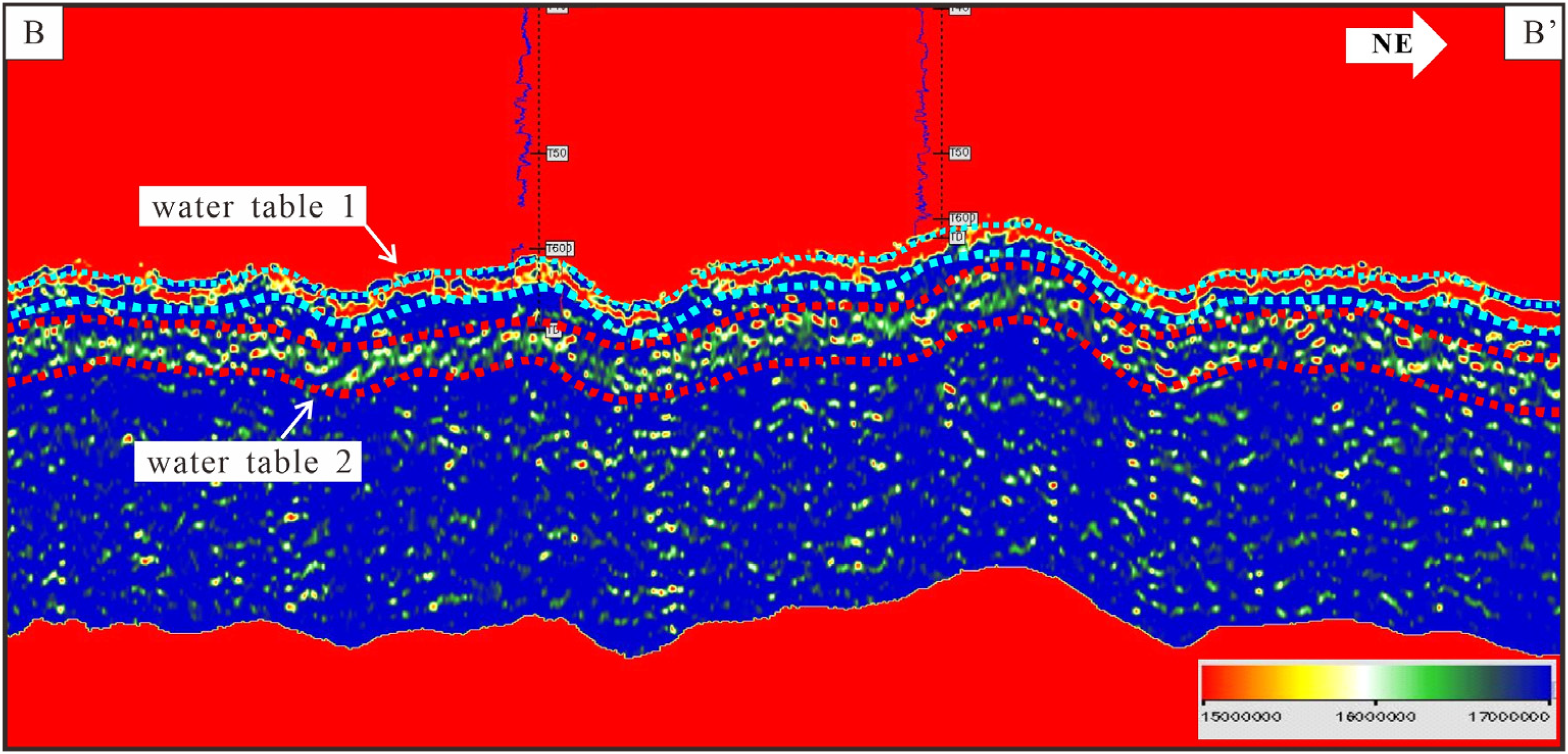
During the Eocene–Oligocene, the study area continued to accept deposition (Figure 1(f)) (Jiao et al., 2018). During this period, the water body fluctuated frequently. The buried hill submerged underwater was passively lifted to a high position under the uneven settlement of the block, and then the water body flowed through the fault to the interior of the bedrock for lateral dissolution. Horizontal dissolution fractures and caves were extremely well developed, in which the porous limestone layer was completely transformed into a type of submerged network conduit (Figure 18(d)). At least two water tables were identified from the Eocene. The Oligocene had evolutionary characteristics similar to the Eocene, and at least two groundwater levels can be recognized (Figure 18(d)). In summary, there are at least three to four phases of the identifiable water table in the study area (Figures 18(e) and 19).
Prestack P-wave inversion impedance profile in the Carboniferous Weixi’nan Sag.
Groundwater flows rapidly, leading to ongoing karstification in the study area once it enters the water. The horizontal dissolution near the water table is particularly strong, resulting in karst development. Therefore, compact and porous limestone may be transformed into large conduits and caves through chemical and mechanical dissolution (Figure 18(d) and (e)). Additionally, diagenetic fluid submerged underwater for an extended period may partially or completely cement (fill) the reservoir spaces, such as pores and caves formed in the early stages (Figure 18(d) and (e)). Over time, the buried hill that first enters the water experiences more severe cementation, with most dissolution fractures and pores/caves cemented by calcite (Figure 18(d) and (e)). The calcite cementation reduces the physical properties of the reservoir space to a certain extent, which affects the subsequent flow of karst water. The core observation indicates that the No. 2 structural belt has significantly stronger cementation than the No. 1 structural belt, with the No. 2 structural belt entering the water earlier than the No. 1 structural belt, thus confirming the above issues.
Compared to modern marine karst, the intensity of karst-mixed dissolution in the study area is significantly lower. Based on cave observations and the core recovery of drilling breaks and leakage, the scale of cave formation in the study area is significantly narrower than that in the Dania area (3.5 km wide) and the Yucatan Peninsula (8–12 km wide) (Baceta et al., 2007; Smart et al., 2006). Furthermore, the dissolution pores are not as strong as those in the two regions. Compared with the karst of modern seawater, the salinity in the study area may be lower, which reduces the impact of mixing corrosion. Moreover, low-salinity seawater results in decreased ionic strength and low calcite saturation, which is not conducive to generating an unsaturated mixture (Plummer, 1975). As a result, the degree of undersaturation and dissolution ability in the mixing zone is reduced, resulting in narrower caves and sparse dissolution pores.
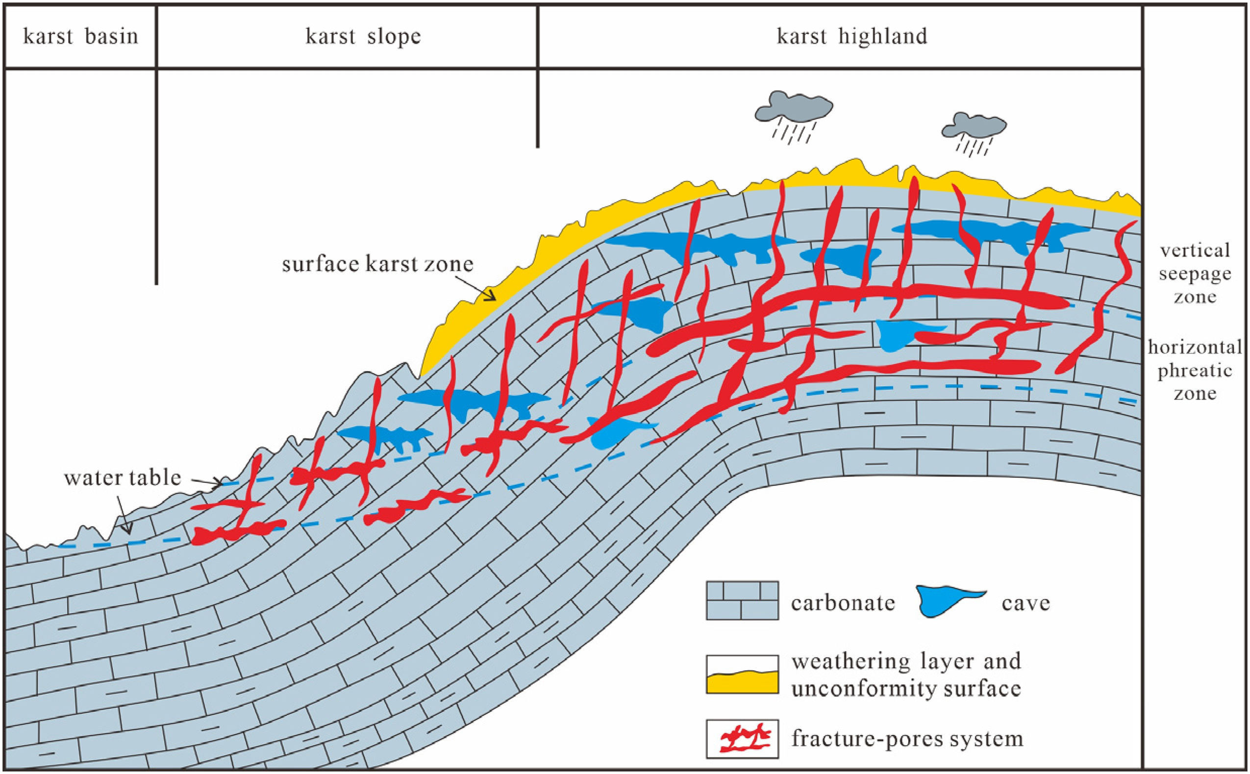
Impact of the epigenetic karst on the reservoir
The preceding analysis indicates that the epigenetic karst is primarily characterized by facies control, with dissolution pores and caves mostly occurring in bioclastic limestone beds. To demonstrate improvements in reservoir physical parameters, we examined the log porosity. Considering well A1 as an example (Figures 8 and 9), we found that the average porosity of beaded dissolution pores and reticular conduits can reach 5.18%, while the average porosity of microfractures and small conduits is 2.54%. The porosity of bioclastic limestone with dissolution pores and reticulated fractures is higher than that of micritic limestone with microfractures and small conduits. These characteristics imply that dissolution enhances reservoir quality.
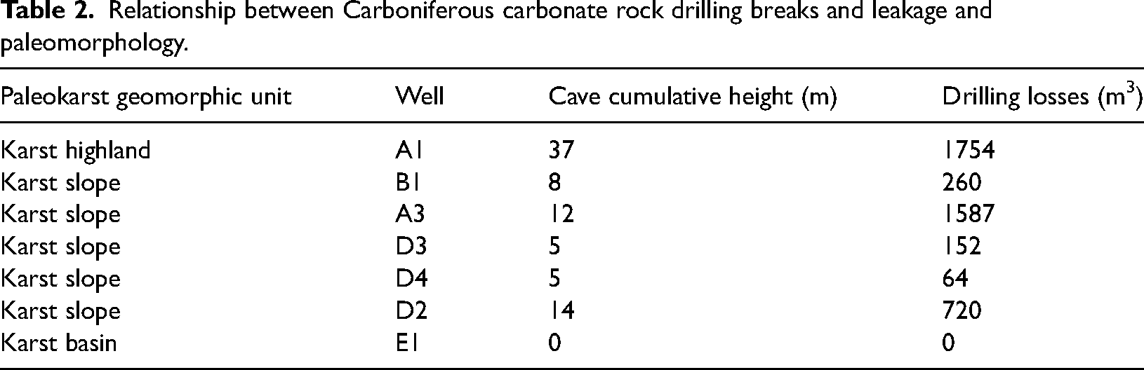
Because of the heterogeneity of carbonate reservoirs and the presence of cave systems, analyzing reservoir physical properties using small-diameter core samples is extremely difficult. To compensate for these limitations, it has been proposed to integrate paleogeographic characteristics, drilling data, and oil and gas production data to comprehensively demonstrate the impact of karstification on reservoir quality (Liu et al., 2020; Yang et al., 2014, 2021). Therefore, a comprehensive analysis was conducted on the karst landforms (Figure 20) and data on drilling break and leakage (Table 2) in the study area. The findings revealed that the cumulative height of caves in karst highlands at drilling sites can reach up to 37 m, accompanied by a significant volume of drilling losses (1754 m3). On the other hand, the average cumulative height of caves in karst slopes is 8.8 m, with drilling losses averaging 556.6 m3. No caves or drilling losses were observed during drilling in the karst basins. As a result, the karst highlands and karst slopes in the Weixi’nan Sag are believed to be karst development areas (Zhang et al., 2022a, 2022b).
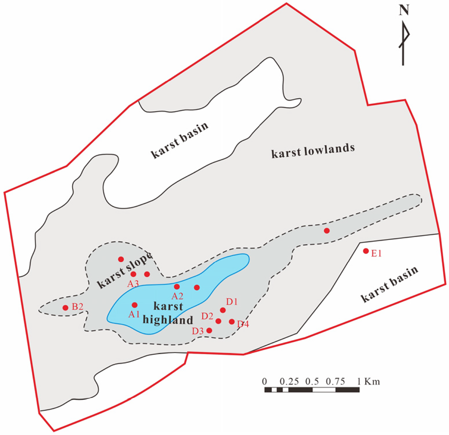
Paleoplatform geomorphology in Weixi'nan sag (according to Yang et.al. 2021).
Relationship between Carboniferous carbonate rock drilling breaks and leakage and paleomorphology.
In conclusion, high-quality facies-controlled karst reservoirs are developed in the Carboniferous karst slopes and karst highlands in the study area, which belong to the typical karst reservoirs (Wen et al., 2009; Xiao et al., 2016; Yang et al., 2021; Zhang et al., 2022a, 2022b). This differs from traditional karst reservoirs typically concentrated in the karst slope/transition zone. Scholars generally believe that oversaturated CaCO2 and low-lying water that cannot circulate will cause extensive cementation to fill dissolution pores and fractures in karst basins, making it difficult to develop high-quality reservoirs (Xiao et al., 2016). Karst slopes and karst highlands are covered by non-permeable mudstone layers after exposure, which are susceptible to anticline stratigraphic traps. Therefore, they may be favorable sites for oil and gas accumulation and can be used as new targets for future oil and gas exploration.
Conclusions
During the Late Permian and Triassic periods, the Carboniferous carbonate rocks underwent uplift and exposure due to the Indo-China movement. The Carboniferous strata underwent shallow burial and remained exposed for a considerable period, forming epigenetic karst along the island/platform margin. The Carboniferous carbonate karst can be longitudinally classified into three zones: the surface karst zone, the vertical vadose zone, and the horizontal phreatic zone. The Carboniferous karst underwent three primary karst environments: syngenetic karst, epigenetic karst, and medium-deep buried karst. The epigenetic karst environment is significant and is generally characterized by intense karstification and wide distribution.
The Carboniferous basement developed a weathering crust and its remnants, and the underground karst underwent differential dissolution and filling, exhibiting typical facies-controlled characteristics. Bioclastic limestone karst is well developed, often with reticular dissolution pores and caves, while micritic limestone karst is underdeveloped, primarily featuring microfractures. The late tectonic activity resulted in a complex fault system, which facilitated vertical migration of karst water, connected bioclastic limestone and dense micritic limestone layers, and promoted the development of facies-controlled karst systems in multiple layers simultaneously.
The Carboniferous karst model is similar to the traditional karst model, with some notable differences. High-quality karst reservoirs develop in karst slopes and karst highlands, forming oil and gas reservoirs on a certain scale, which provides new insights for regional exploration.
Highlights
Syngenetic karst, epigenetic karst, and buried karst were identified in the Carboniferous of the Weixi’nan Sag.
Syngenetic karst is characterized by molds and micritization.
Epigenetic karst was featured by facies-controlled non-selective fabric dissolution.
High-quality karst reservoirs developed in karst highland and karst slope zones.
Footnotes
Acknowledgements
This study is supported by the Zhanjiang Branch of China National Offshore Oil Corporation Study on the distribution law and favorable exploration direction of bedrock-buried hill reservoirs in the Beibuwan Basin (No. CCL2020ZJFN0294). Thank you for providing data and authorizing the publication of this article. We thank the editor-in-chief and two anonymous reviewers for their comments and constructive suggestions, which have greatly improved this article.
Declaration of conflicting interests
The author(s) declared no potential conflicts of interest with respect to the research, authorship, and/or publication of this article.
Funding
The author(s) disclosed receipt of the following financial support for the research, authorship, and/or publication of this article: This work was supported by the China National Offshore Oil Corporation (grant number CCL2020ZJFN0294).