
Abstract
Reconstructing karst palaeogeomorphology is a useful approach to identifying target areas for oil and gas exploration. This study used the elevation method to reconstruct the karst palaeogeomorphology at the top of the 4th member (Z2dn4) of the Dengying Formation (Z2dn) in the Central Sichuan Basin based on 2D and 3D seismic and drilling data. The bottom of the Longwangmiao Formation and the top of the 2nd member (Z2dn2) of the Z2dn were optimized as the upper and lower base levels, respectively. The reconstructed palaeogeomorphology was divided into five types – slopes, erosional peneplains, monadnocks, domes and depressions – according to their morphology, scope and gradient, allowing inference of the palaeohydrological conditions. Slopes were subdivided into gentle (<1.2°) and steep (≥ 1.2°; maximum gradient around 16°). Reservoirs on steep slopes and monadnocks are the most developed, owing to their considerable hydraulic head differences, strong palaeohydrodynamics, and intense erosion and incision. Steep slopes with more developed karst porosities are banded and immediately adjoin a regional hydrocarbon generation centre. Hydrocarbons generated in this centre tend to migrate laterally and become entrapped in porous slopes and their vicinities. Consequently, hydrocarbons move upward along steep slopes and, preferentially, slopes and monadnocks. Thus, the steep slope zone and its vicinity (including some monadnocks, gentle slopes and peneplains) are the most favourable areas for exploration of hydrocarbon reservoirs and should be the primary targets.
Keywords
Introduction
Carbonates are widely distributed soluble rocks with the potential to form high-quality reservoirs under the influence of karstification (Agosta et al., 2010; Cross et al., 2021; Florea and Vacher, 2006; Liu et al., 2019). Carbonate petroleum reserves account for more than half of global petroleum reserves (Firme et al., 2021; Su et al., 2021; Zhao et al., 2014) and are closely related to palaeokarstification (Araújo et al., 2021; Liang and Hou, 2021; Liu et al., 2019). Some 20–30% of global oil and gas resources are related to disconformities (Burchette, 1996; Fritz et al., 1993). The Ediacaran Dengying Formation (Z2dn) of the Sichuan Basin, China, represents a set of deposits marked by a regional disconformity at the top of the unit (Li et al., 2019). The Dengying deposits are affected by this disconformity and represent an important reservoir related to the development of a weathering crust (Luo et al., 2017; Zhou et al., 2020). The weathering interface at the top of the Dengying deposits implies disconformable contact with the good source rocks of the lower Cambrian Maidiping Formation (Є1m) and Qiongzhusi Formation (Є1q), thereby forming an excellent source–reservoir combination (Qu et al., 2020). In recent years, petroleum exploration in the Z2dn of the Gaoshiti–Moxi area of the Central Sichuan paleo-uplift has made great breakthroughs (Liu et al., 2015; Xie et al., 2019). By the end of 2018, the total proven reserves of natural gas were 1 × 10¹² m3, and cumulative gas production reached 4.19 × 10¹⁰ m3 (Li et al., 2020), demonstrating the good potential of these Neoproterozoic carbonate rocks. Therefore, this area has become a new exploration focus for the Sichuan Basin and provides an important example of deep–ultradeep carbonate petroleum exploration.
The main karstification type forming vugs and caverns in the Z2dn4 remains debated. There is a general consensus that the whole Sichuan Basin was uplifted by episode II of the Tongwan Movement and experienced long-term meteoric freshwater leaching and dissolution (Hao et al., 2017; Luo et al., 2015; Wei et al., 2016; Yang et al., 2016; Zhou et al., 2016). To comprehend the main types of karstification in the Z2dn4, understanding the related eogenetic and epigenetic karst processes is necessary. Eogenetic karst refers to karstification in early diagenetic stage, which is characterized by high initial matrix porosity and permeability in the rock. Reported examples are mainly located in small isolated carbonate islands and exposed portions of attached carbonate platforms (Florea and Vacher, 2006, 2010). Epigenetic karst refers to late diagenetic karstification, which features much lower initial matrix porosity and permeability with stabilized minerals, and is generally located in hinterlands (Tang et al., 2013). Because of the presence of a widespread disconformity at the top of the Z2dn4, many scientists suppose that eogenetic/epigenetic karstification has caused the development of reservoirs (Che et al., 2019; Yang et al., 2014a; Yang et al., 2014b). However, due to prominent differences in reservoir volume and commercial gas productivity between platform margins and interiors (Jin et al., 2017), epigenetic karstification is not applicable since deep burial before the epigenetic stage would have reduced these differences between all parts of the platform (Tan et al., 2015). The karst products of the Z2dn4 in the Central Sichuan Basin differ distinctly from those of the Ordovician in the Tarim Basin. In other words, they are seldom related to the development of fractures and crevices but are closely related to lithofacies, especially microbial and granular rocks, and geographical position (Jin et al., 2017). On the basis of the karst features of the Z2dn4, the eogenetic karst theory has been applied to interpret these karst phenomena (Hou et al., 2021; Jin et al., 2017, 2020; Tan et al., 2015) and a coupled pattern has been established. The eogenetic karst principle can interpret the differentiation of karst porosities in platform margins and interiors more clearly. A burial karstification pattern has been proposed to explain the difference in karst development between the platform margin and interior of the Z2dn4 in the Northern Sichuan Basin (Li et al., 2019). It occurs some distance away from the Mianyang-Changning intracratonic sag that has thicker source rocks, which reduces the dissolution capability of organic acids due to the high migration distance. Hence, both eogenetic and burial karstification seem reasonable. However, in the burial stage, the fluids produced in the closed diagenetic environment are much less abundant than those produced in the open atmospheric environment, and a net increase in porosity attributed to reservoirs is more likely to stem from the eogenetic stage rather than the burial stage. Therefore, it has been suggested that burial karstification is simply a kind of reworking and adjustment of pre-existing reservoirs (Tang et al., 2013; Zhou et al., 2020).
The key factor controlling the development and distribution of karst reservoirs is karst palaeogeomorphology. Thus, the distributions of such reservoirs are mostly predicted based on the reconstruction of palaeogeomorphology (Li et al., 2013). Karst topography is a result of the interaction between multiple karstification events and soluble rocks under complex diagenetic conditions (Albertão et al., 2011; James and Choquette, 1984). The consequent morphology and distribution are important characteristics of the degree of karstification development (Yan et al., 2016). Typical karst topography is essentially correlated with surface and subsurface dissolution and subsequent solution-induced collapse; hence, topography and hydrology are closely correlated (Ford and Williams, 2007; Waele et al., 2009) and the morphological relief depends largely on variations in hydraulic potential. Karstification of the palaeogeomorphology controls the development and position of reservoirs and determines the formation and distribution of secondary carbonate reservoirs (Hou et al., 2020; Loucks et al., 2004; Ronchi et al., 2010; Sayago et al., 2012; Zhu et al., 2019). Recent exploration and research show that the main factors controlling karst reservoirs in the Gaoshiti–Moxi area of the Central Sichuan Basin are sedimentary facies and karstification, with the latter being key to the formation of high-quality reservoirs (Duan et al., 2019; Shan et al., 2017; Wen et al., 2017). Hence, karst geomorphology was reconstructed and classified using the topographical framework of paleokarst disconformities. This can be used to analyse the relationship between palaeogeomorphology and reservoirs, and associate specific palaeogeomorphological units with potential hydrocarbon reservoirs, thereby effectively predicting the distribution of karst reservoirs in the Z2dn4 within the Central Sichuan Basin.
Geological setting and stratigraphy
The Sichuan Basin is located in Southwest China and covers an area of approximately 2.6 × 10⁵ km2. It is a typical large petroliferous basin that covers the Precambrian Yangtze Craton (Liu et al., 2021). More than 20 hydrocarbon-bearing strata are contained in the entire basin, among which the upper Sinian (Ediacaran) Z2dn contains the oldest set of marine sedimentary carbonate reservoirs (Wei et al., 2005, 2016). The Central Sichuan Basin is located in the eastern part of the Leshan–Longnvsi palaeo-uplift (Figure 1) and covers an area of approximately 3.54 × 10⁴ km2. This palaeo-uplift experienced a stage of initial uplift in the middle and late Sinian, a stage of denudation at the end of the Silurian, and a tectonic adjustment stage in the Hercynian, IndoSinian, Yanshanian and Himalayan periods that shaped the present structural features (Jiang et al., 2014; Li et al., 2013; Xu et al., 2012). The Leshan–Longnvsi palaeo-uplift is characterized by early formation, a wide range of effects and long duration (Luo et al., 2015; Yang et al., 2016; Zhou et al., 2016). Its long-term, multicycle, pulsating, complex evolution has exerted a significant impact on hydrocarbon accumulation in the Sinian Z2dn (Du et al., 2014; Jiang et al., 2014; Yang et al., 2016).
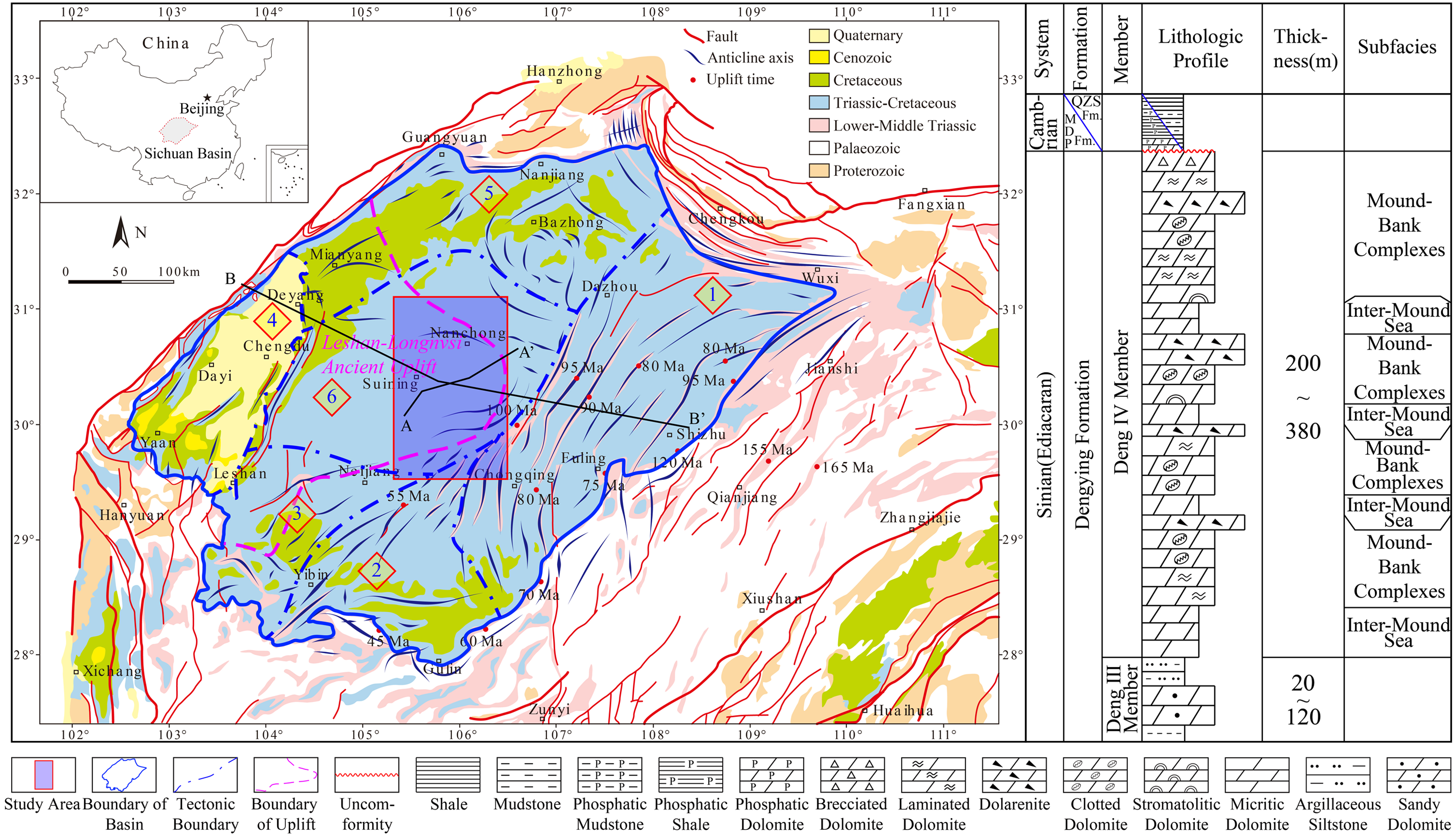
Tectonics of the Sichuan Basin and stratigraphy of the Z2dn4. Numbers within diamonds represent the locations of (1) a high and steep structural belt in the Eastern Sichuan Basin; (2) a less steep structural belt in the Southern Sichuan Basin; (3) a less steep structural belt in the Southwest Sichuan Basin; (4) a high and steep structural belt in the Western Sichuan Basin; (5) a low and gentle structural belt in the Northern Sichuan Basin; and (6) a gentle structural belt in the Central Sichuan Basin.
The Z2dn4 of the Central Sichuan Basin constitutes the uppermost portion of the Z2dn and is predominately composed of carbonate platform microbial and micritic dolomites. The member has a thickness of 200–380 m and is unconformable with the overlying Є1m or Є1q and conformable with the underlying third member of the Z2dn (i.e. Z2dn3; Figure 1). At the end of the Z2dn's deposition, affected by episode II of the Tongwan Movement, the carbonate platform was exposed above the sea level and eroded and leached by atmospheric freshwater, forming a widespread disconformity between the Sinian and Cambrian strata (Yang et al., 2014a), as well as a set of high-quality karst weathering crust reservoirs of mound-shoal complexes on top of the Z2dn4 (Wang et al., 2014; Wei et al., 2016). Development of the karst system was largely influenced by the palaeoclimate; that is, recharge by meteoric freshwater. Warm temperatures contributed to the carbonate dissolution process because the rate constants of carbonate mineral dissolution increase with temperature. This produces more CO2 for acid fluid formation due to the oxidation of more organic materials (Moore and Wade, 2013). Tropical humid and warm environments supply abundant and frequent precipitation that recharges karst fluids, which facilitates the generation of karstification and karst products. Metastable carbonate minerals are also rapidly stabilized and transformed into stable minerals under such climates (Morse and Mackenzie, 1990). In the Sinian, with the break-up of the Rodinia supercontinent, the South China Block dispersed as a small block around 30° N and South China (including the Sichuan Basin) was surrounded by a tropical ocean (Hoffman and Li, 2009). The palaeoclimate was warm and wet, providing enough meteoric freshwater for later karstification after tectonic uplift during Tongwan episode II. On account of the wide range of exposure of the carbonate platform in the Yangtze Block, massive amounts of organic material from the seafloor oxidized to produce large amounts of CO2. This enhanced the partial pressure of CO2 in the atmosphere and accelerated chemical weathering of crustal rocks in the Yangtze Block. Thus, considerable terrigenous inputs generated from extensive karstification shed into the oceans via meteoric freshwater and negative excursion of δ13C evidently occurred across the Sinian and Cambrian boundary (Li et al., 2017). The increased CO2 partial pressure would have also elevated atmospheric temperatures, further facilitating chemical weathering (Beaugrand et al., 2015; Jaraula et al., 2013; Joachimski et al., 2012) due to greater precipitation and freshwater acidity. Karstification of the Z2dn4 in the upper Yangtze Block would also have intensified due to the favourable palaeoclimatic conditions.
Materials and methods
Research on karst palaeogeomorphology in relation to petroleum geology has primarily focused on its control of hydrocarbon accumulation for the prediction of oil and gas accumulation zones to guide exploration (Zhao et al., 2017). Currently, commonly used methods for restoring karst palaeogeomorphology include the residual thickness and impression methods (Jin et al., 2017; Liu et al., 2015; Li et al., 2013; Wang et al., 2014).
In the past decade, there have been several reconstructions of the karst palaeogeomorphology at the top of the Sinian strata in the Gaoshiti–Moxi area of the Central Sichuan Basin. The use of residual thickness and impression methods and their combination has achieved some results (Jin et al., 2017; Li et al., 2013; Liu et al., 2015; Wang et al., 2014). Nonetheless, the accuracy of the reconstructed palaeotopographies is greatly affected by the disadvantages of the impression and residual thickness methods (Yan et al., 2016). Interpretations of the reconstructed karst palaeogeomorphology at the top of the Sinian in Central Sichuan basin, by means of residual- thickness method, come to be inconsistent with the gas-testing productivity (Jin et al., 2017). On the seismic section of residual-thickness method, crossing the Mianyang-changning intracratonic sag and the adjacent carbonate platform, evident onlaps that indicate the slope-break belt occurred mistakenly in the platform interior, demonstrating disagreement of the residual-thickness paleogeomorphology with objective reality and inapplicability of the method for this interface (Jin et al., 2017). In addition, division of the four members of the Dengying Formation can be carried out efficiently only in the range of the Sichuan Basin as lithological differences; for the periphery of the basin, character of the four-member division for the Dengying Formation is no longer practicable since sedimentary variations (Li et al., 2018). Thus, it is not feasible for the study area to implement the residual-thickness method for paleogeomorphological reconstruction simply because of basin-scope geomorphological inconsistency brought about by usage of thickness of the Z2dn4. The key for impression method is the selection of the upper base level, different choices of which will definitely lead to distinct results. Serving the bottom boundary of the Longwangmiao Formation (Є1l) as the upper base level, the reconstructed paleogeomorphological units in the Gaoshiti-Moxi area was divided into highland (or tableland) and gentle slopes dipping to the northwest, revealing the main westward discharge direction of runoffs (Li et al., 2018; Liu et al., 2020; Zhu et al., 2018). In contrast, the karst landform restored in the same region, making use of the top boundary of the Є1l as the upper base level, was interpreted with analogous mode from Marche, Italy as tablelands and transitional slope (Jin et al., 2017). Regarding the flooding surface inside the Canglangpu Formation (Є1c) as the upper base level, employing the impression method, result of the reconstructed paleogeomorphology of the Gaoshiti-Moxi area manifested a larger range of tableland whereas the gentle slope area was much limited (Yan et al., 2020).
Using drilling data from more than 40 wells and 2D and 3D seismic data, the elevation/double boundary method (Yan et al., 2016; Zhao et al., 2018) (hereafter referred to as the elevation method) was employed to reconstruct the karst palaeogeomorphology at the top of the Sinian strata in the Central Sichuan Basin. A number of achievements have been obtained by using this method to reconstruct the karst palaeogeomorphology of the middle Ordovician Majiagou Formation in the Ordos Basin (Yan et al., 2016; Zhao et al., 2018).
The elevation method is similar to the impression method in principle. The key is to select the superstrata that fill and level the karst weathering crust surface to characterize the highs and lows of the palaeogeomorphology. The major difference between these methods is that, in the elevation method, the moldic thickness of the original superstrata is converted into elevation data according to a lower base level. After levelling off the upper base level, the lower base level that is as close as possible to the disconformity should also be selected. The selected lower base level should represent the closest structural surface. A reference level with an elevation of 0 m is set from the lowest point of this lower base level. Compared with the impression method, the elevation method can quantitatively characterize the topographic relief of the disconformity as it incorporates the thickness of the weathered stratum itself. In contrast, the impression method can only depict the topographic relief (high or low) based on the moldic thickness of overlying strata, and the relief quantities are totally controlled by the selection of the upper base level. The specific steps of this method are as follows:
Selection of the upper base level is the key to palaeogeomorphological reconstruction. Its main principles are (Yan et al., 2016): (1) It should fill and level the underlying weathering disconformity; (2) the selected upper base level must be isochronous and roughly correspond with a transgressive surface or maximum flooding surface; and (3) the distance between the upper base level and weathering disconformity (i.e. the moldic thickness) should be minimized. The closer the distance, the more detailed the description of the geomorphological features of the weathering crust; furthermore, the adverse effect of later tectonics on the accuracy of the reconstruction can be minimized. (4) The selected upper base level can be identified and precisely traced in seismic profiles. The selection of a lower base level should meet the requirements of (3) and (4) as much as possible. After flattening the upper base level, the lowest structural position of the lower base level is found (namely, the point of maximum thickness between the upper and lower base levels); then, a flat surface can be extended (i.e. a horizontal reference plane with an elevation of 0 m from this point). The elevations (HE) of corresponding points between the horizontal reference plane and weathering disconformity can be calculated using the maximum thickness between upper and lower base levels (HTM) minus the thickness between upper base level and disconformity (HM), then plotted. An equation that summarizes the operation is given as follows:
where HE is the elevation, HTM is the maximum thickness between the upper and lower base levels, and HM is the moldic thickness. The elevation calculation model is displayed in Figure 2.

Then, time-domain data of the upper and lower base levels and the disconformity are acquired from interpretation of the three horizons using drilling data and 2D and 3D seismic data. Corresponding depth-domain data are obtained through time-depth conversion according to calculated interval velocities. The thickness from the upper base level to the weathering surface (moldic thickness), the thickness from the weathering surface to the lower base level (residual thickness) and the total thickness between the upper and lower base levels are obtained by subtracting the depths of the three interfaces. Subsequently, the maximum thickness is subtracted from the moldic thickness and total thickness within the research area, and the palaeogeomorphological elevations are obtained.
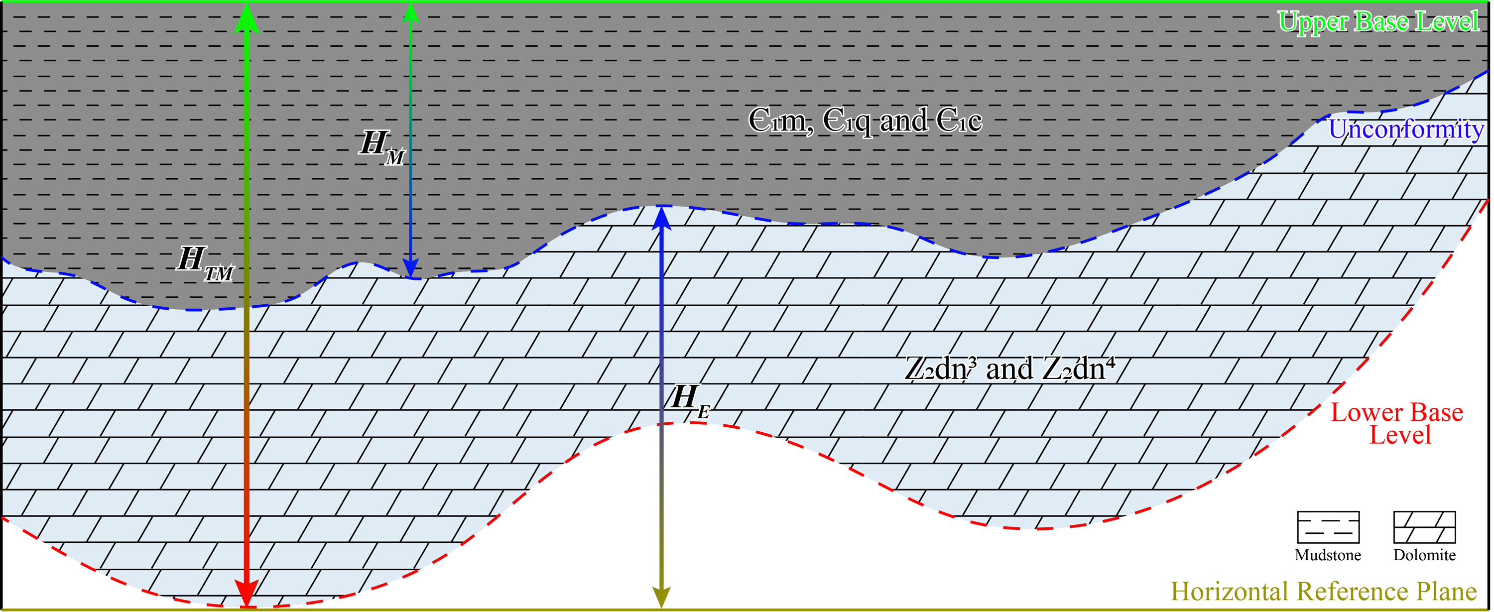
Principle of palaeogeomorphological reconstruction via the elevation method (modified from Yan et al., 2016; Zhao et al., 2018). The moldic thickness (HM) is the thickness of the superstrata filling the disconformity, where the upper base level represents a horizontal plane at the top of the superstrata. The lower base level represents the closest structural surface to the disconformity, and the horizontal reference plane is a horizontal plane extending from the lowest structural point of the lower base level. Thus, the elevation (HE) represents the thickness between the disconformity and lower base level, while the maximum thickness (HTM) represents the thickness between the upper base level and horizontal reference plane. The palaeogeomorphology can thus be characterized by the HE data of the disconformity (i.e. HTM − HM).
Results
Selection of base levels
With regard to the reconstruction of the karst palaeogeomorphology at the top of the Z2dn4 in the Central Sichuan Basin, two base levels were selected: the upper base level, which was the bottom boundary of the Є1l, and the lower base level, being the top of the Z2dn2 (Figure 3). The reasons for this selection are as follows.
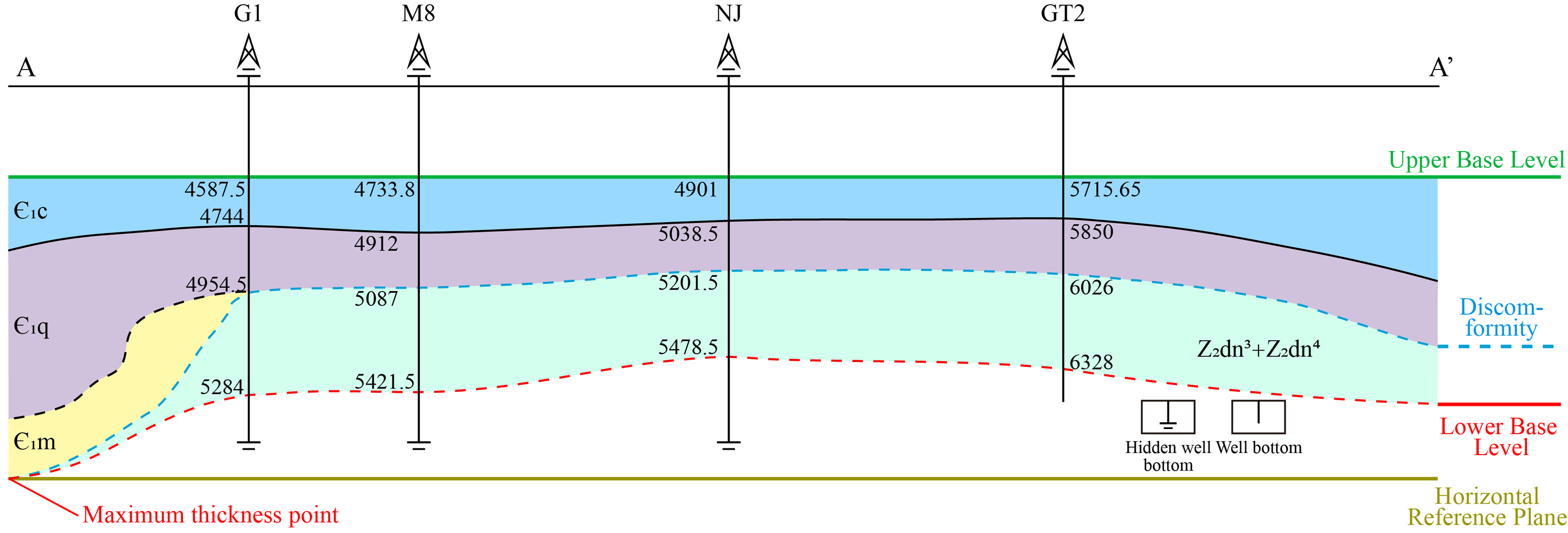
Selection of the upper and lower base levels (modified from Liu et al., 2015). The interface between the Є1l and the Є1c was selected as the upper base level, and the interface between the 3rd and 2nd members of Z2dn was selected as the lower base level. The numbers in this figure show the drilling depths of each horizon of each well (in metres). The ‘Maximum thickness point’ represents the lowest structural points of the Z2dn3 and Z2dn4 in the section, respectively. For the section location, see Figure 1.
The lower Cambrian successions of the Є1m, Є1q and Є1c stacked on top of the Z2dn in the Sichuan Basin represent a conformable group formed by transgression–regression cycles. They largely fill up and level the palaeogeomorphology at the top of the Z2dn. The variation in the thickness of the Є1l is relatively low horizontally, indicating that the Sichuan Basin's tectonic activity had stabilized when the Є1l was deposited (Yang et al., 2016). The bottom boundary of the Є1l has a transitional lithologic interface of clastic rocks on top of the Є1c with carbonates at the bottom of the Є1l. Lithofacies and logging curves are categorized by abrupt variations between the Є1c and Є1l. A bed of purplish-red sandy mudstone (known as the lower red bed) is stably distributed on top of the Є1c regionally, exhibiting relatively strong reflection in seismic sections (Figure 4). Consequently, the bottom boundary of the Є1l can be distinguished and traced. Together with 2D and 3D seismic data from the Central Sichuan Basin, the bottom boundary of the Є1l is optimized as the upper base level for reconstruction of the karst palaeogeomorphology at the top of the Z2dn.
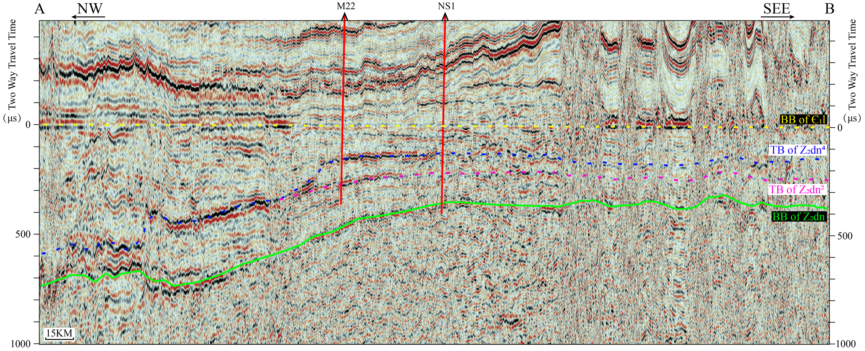
Seismic reflection profile of the upper and lower base levels. The bottom boundary of the Є1l and top boundary of the Z2dn2 are the upper and lower base levels, respectively, due to their approach to the top boundary of the Z2dn (the disconformity) and comparatively strong and more easily traceable reflections.
The lower base level was selected using the same principle used for the upper base level. The interface between the bottom of the Z2dn3 and top of the Z2dn2 represents broadly distributed across the entire basin. The top of the Z2dn2 is a zonal disconformity that is isochronous. Moreover, the Z2dn3 is one of the marker layers in the region and chiefly consists of fine-grained clastic rocks that notably contrast lithologically and electrically with the dolomites from the superjacent Z2dn4 and subjacent Z2dn2. The bottom boundary is a weathering surface of episode I of the Tongwan Movement, which is traceable by its relatively obvious reflection in the seismic sections (Figure 4). For this reason, it is used as the lower base level.
Classification of the palaeogeomorphological unit
The karst palaeogeomorphology at the top of the Sinian (Figure 5) was plotted on the basis of the difference between the maximum and moldic thicknesses of the Central Sichuan Basin. The palaeogeomorphology of the study area is roughly composed of two parts – bottom land and high land – which are separated by a slope. The high land is the main body of the Z2dn4 platform.
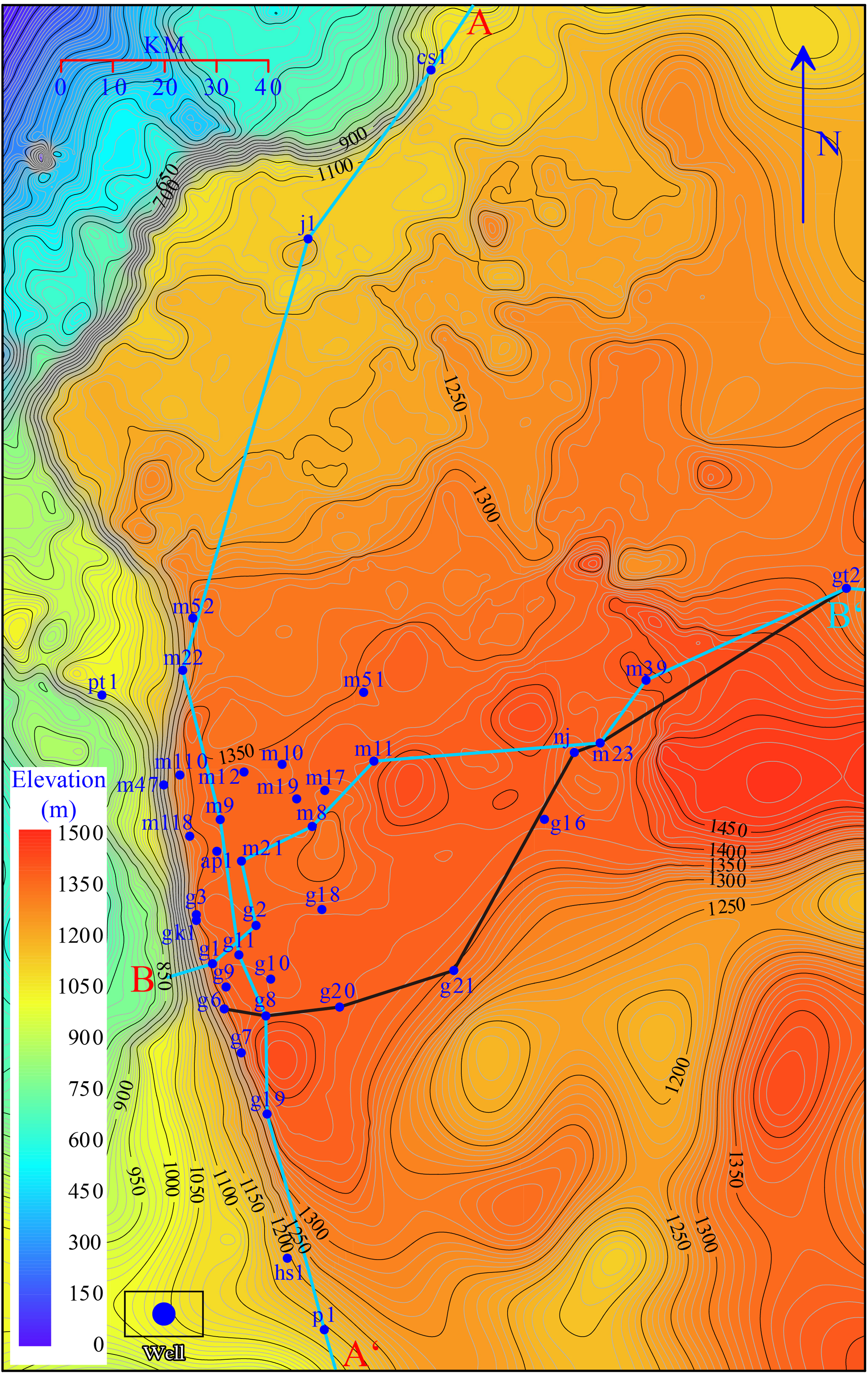
Palaeogeomorphology of the disconformity at the top of the Z2dn in the Central Sichuan Basin. The maximum elevation of this basin approaches 1500 m in the central-eastern part, while the lowest part lies in the northwestern corner of the map. The palaeogeomorphology exhibits lowland features in the western and southern parts of the basin. The middle and southeastern parts are at the highest elevation, while the northern part is stepped with a progressively decreasing elevation northward.
Note that there is a steep slope separating the bottom land and high land in the west. The bottom land is a trough called the Mianyang-Changning intracratonic sag, which is the result of various geological processes, such as rifting and erosion (Li et al., 2015; Liu et al., 2016).
Following the reconstruction of the palaeogeomorphology at the top of the Z2dn4 in the Central Sichuan Basin, a slope map was plotted in the light of a digital elevation model (DEM; Figure 6) to characterize the gradient distribution, which contributed to the subsequent geomorphic classification. The maximum slope in this basin lies in the west and reaches almost 16°, representing a steep slope, and is represented by a thick, bright band along the line between wells g19-gk1-m22 (Figure 6). The overall terrain of the dark-blue area is flat with a rather low slope and is separated into pieces by green bands, exhibiting separation of plains by slopes. Green rings of varying size indicate closed circular side slopes (including monadnock and depression side slopes). This variety of traits demonstrates the diversity of palaeogeomorphological units. The karst palaeogeomorphology at the top of the Sinian in the Central Sichuan Basin can be divided into five units: erosional peneplains, karst slopes, monadnocks, domes, and depressions, among which the slopes can be further subdivided into steep and gentle (Table 1). It is clear that gentle slopes occupy most of the area and the peneplains and domes are bounded by gentle slopes, while monadnocks and depressions (except the large one in the south) are mostly bounded by peneplains (Figure 7), which may imply geomorphogenetic relations among the palaeogeomorphological units. Multi-stage peneplains and their bounding gentle slopes present stepped features (Figure 8), indicating the pulsing descent of an erosional basis. The slope rimming the carbonate platform in the west is visually highest in gradient and, thus, is categorised as steep. According to the statistics of the slope gradients, we found that an inclination of 1.2° is suitable for dividing steep and gentle slopes. The slopes (blue-green – green areas) inside the platform are gentle, being <1.2° in gradient.
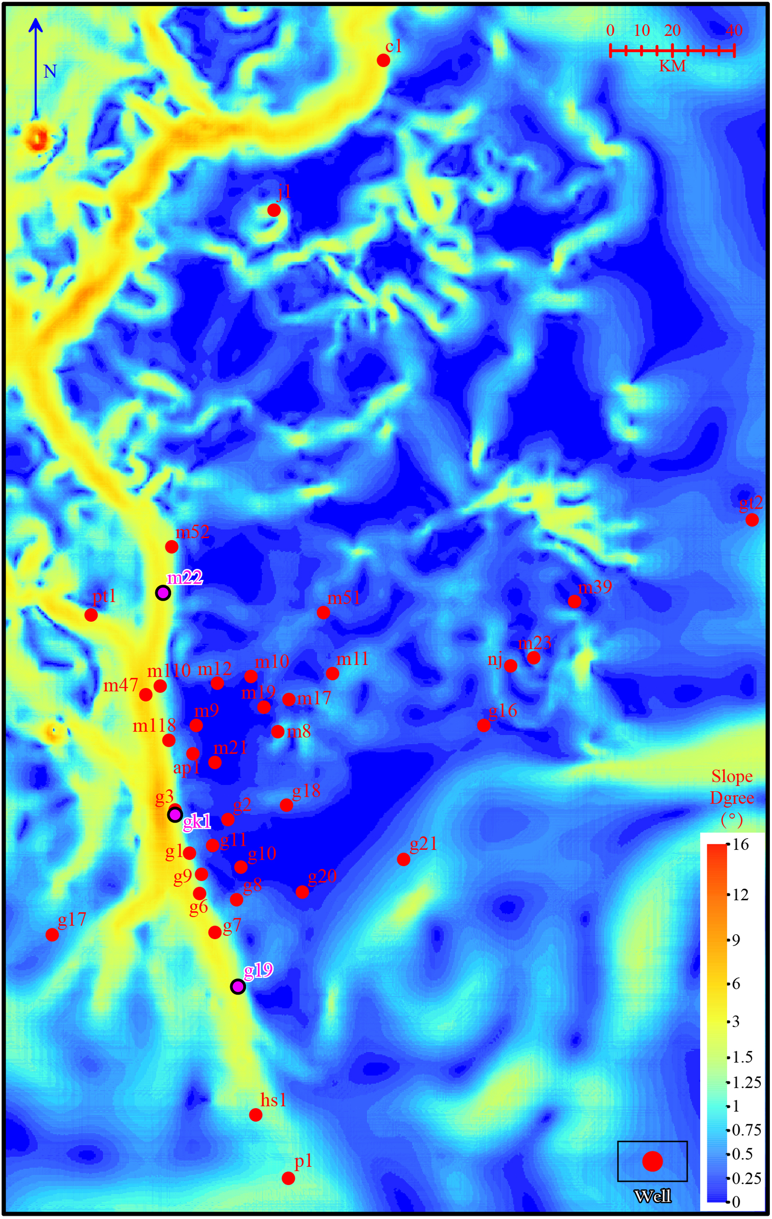
Gradient map of the palaeogeomorphology of the disconformity at the top of the Z2dn4. The maximum gradient at the top of the Sinian in the Central Sichuan Basin is approximately 16°. The warmer colours indicate slopes, including steep, gentle and side slopes. The flat regions contain peneplains, depression bottoms and the tops of monadnocks and domes (dark blue).
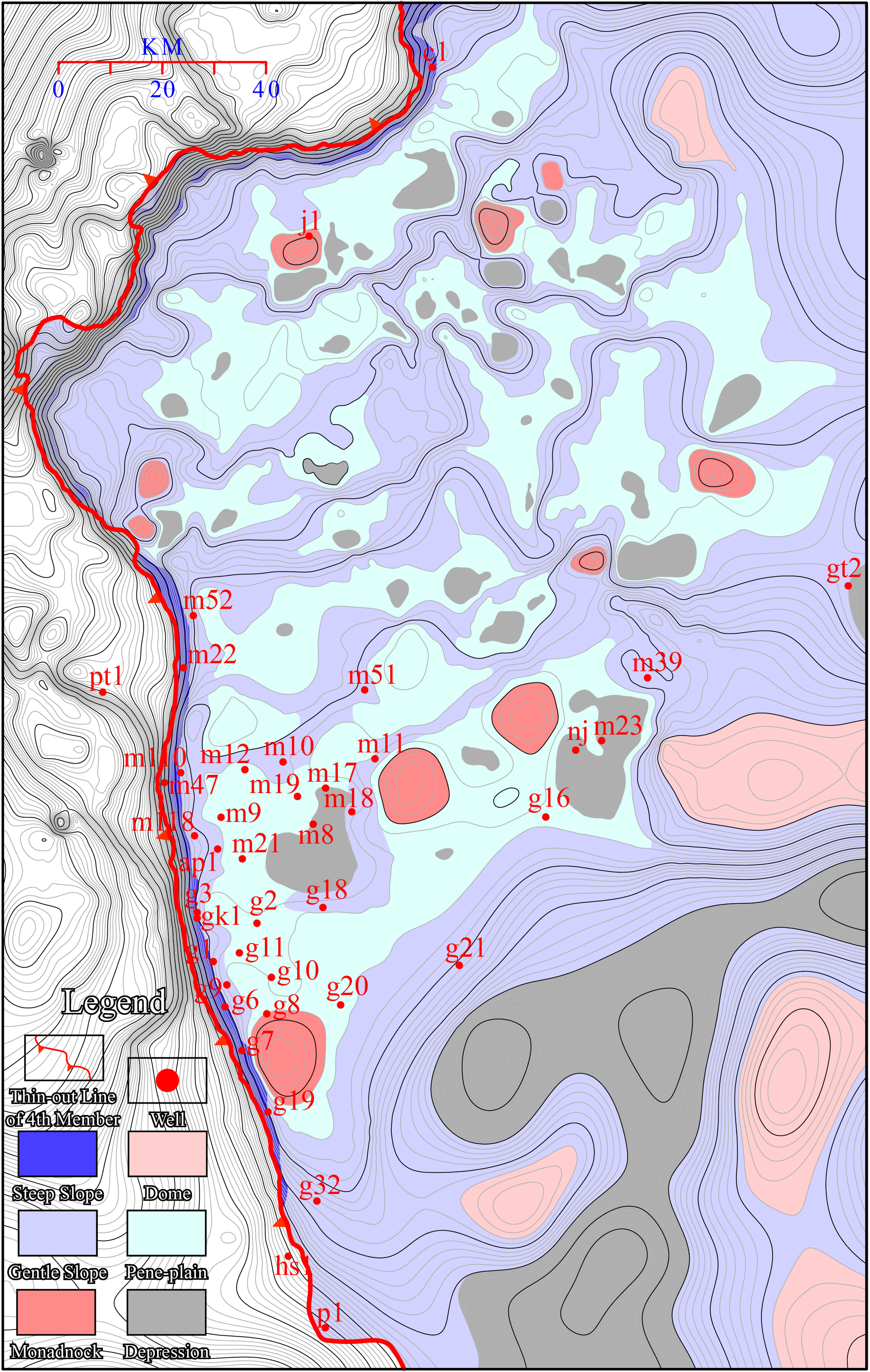
Classification of palaeogeomorphological units associated with the top of the Z2dn4. The slopes (particularly gentle slopes) occupy most of the area of the Central Sichuan Basin. Steep slope rims occur around the Z2dn4 in the west, while gentle slopes prevail in the largest part bounding the flat peneplain. The principal part of the depression is located in the south and the rest of the small depressions are scattered evenly within the peneplain. The monadnocks and domes are surrounded by peneplains and gentle slopes. There are fewer of them than there are depressions, and they are scattered and encircled by peneplains and gentle slopes.
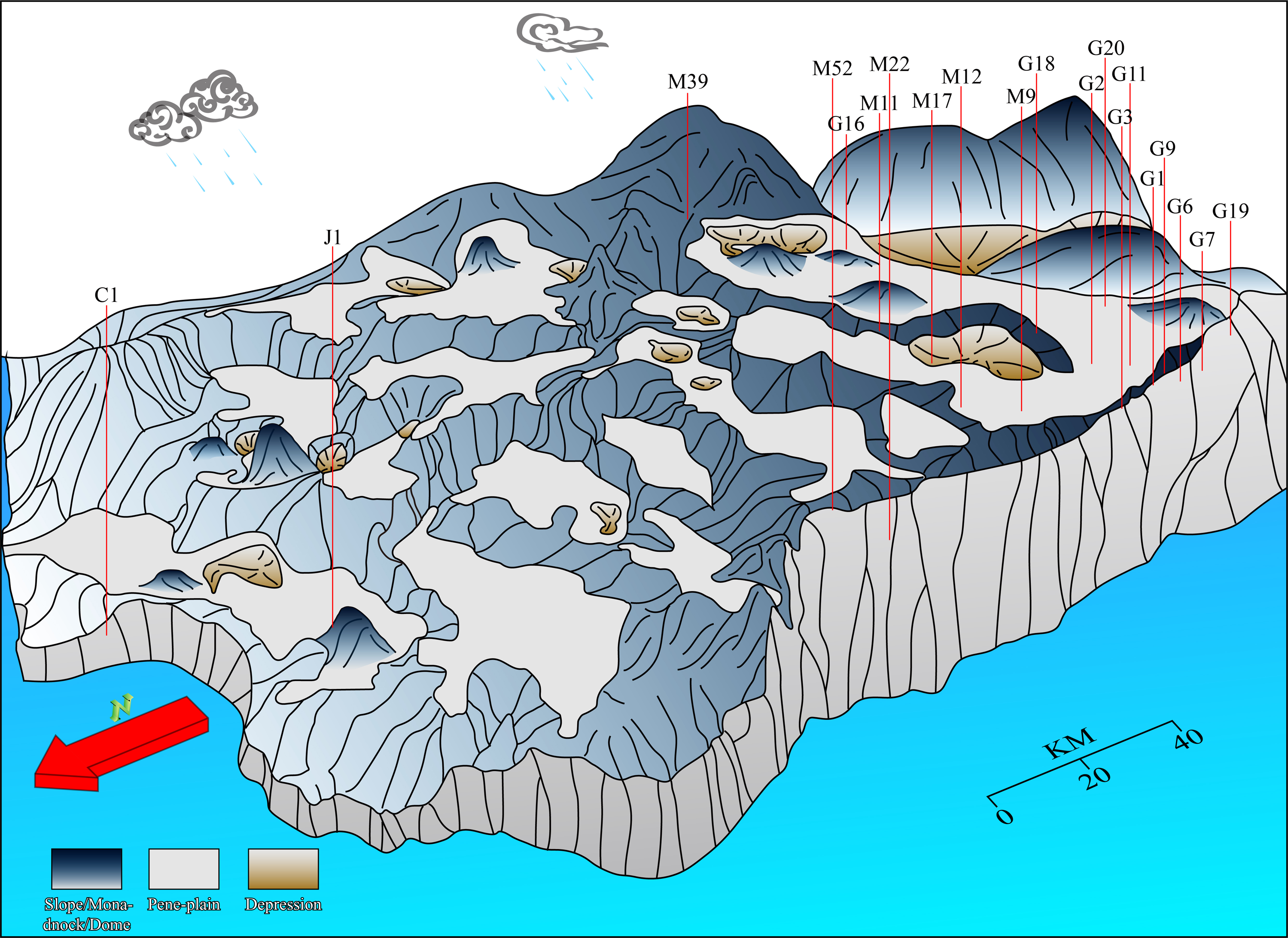
Schematic 3D model of the palaeogeomorphology at the top of the Z2dn.
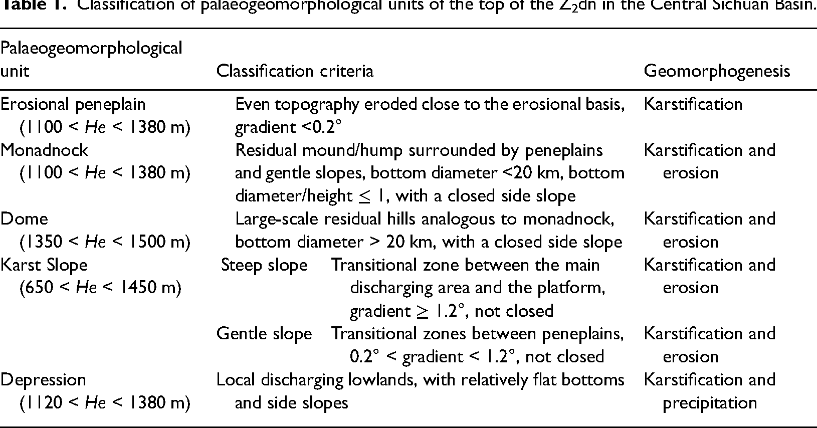
Classification of palaeogeomorphological units of the top of the Z2dn in the Central Sichuan Basin.
Discussion
Factors determining reservoirs
Control of lithofacies distribution
Different lithofacies distributions gave rise to initial differences in porosity in the reservoirs of the Z2dn4. High-quality reservoirs (> 5% porosity) are more prone to develop in microbial rocks, which form mounds and shoals at platform margins. Despite continuous porosity losses in the burial stage due to compaction, rigid frameworks of mound-shoal complexes preserved the porosity more effectively than inter-mound deposits owing to better capability of anti-compaction (Figure 9). Thus, microbial rocks represent preferential conduits for karst fluids after the shallow burial stage. Subsequent internal dissolution of mound-shoal complexes further increased the porosity. Therefore, lithofacies, particularly microbial rocks in mound-shoal complexes, tend to form superior reservoir (> 5% porosity) formation.
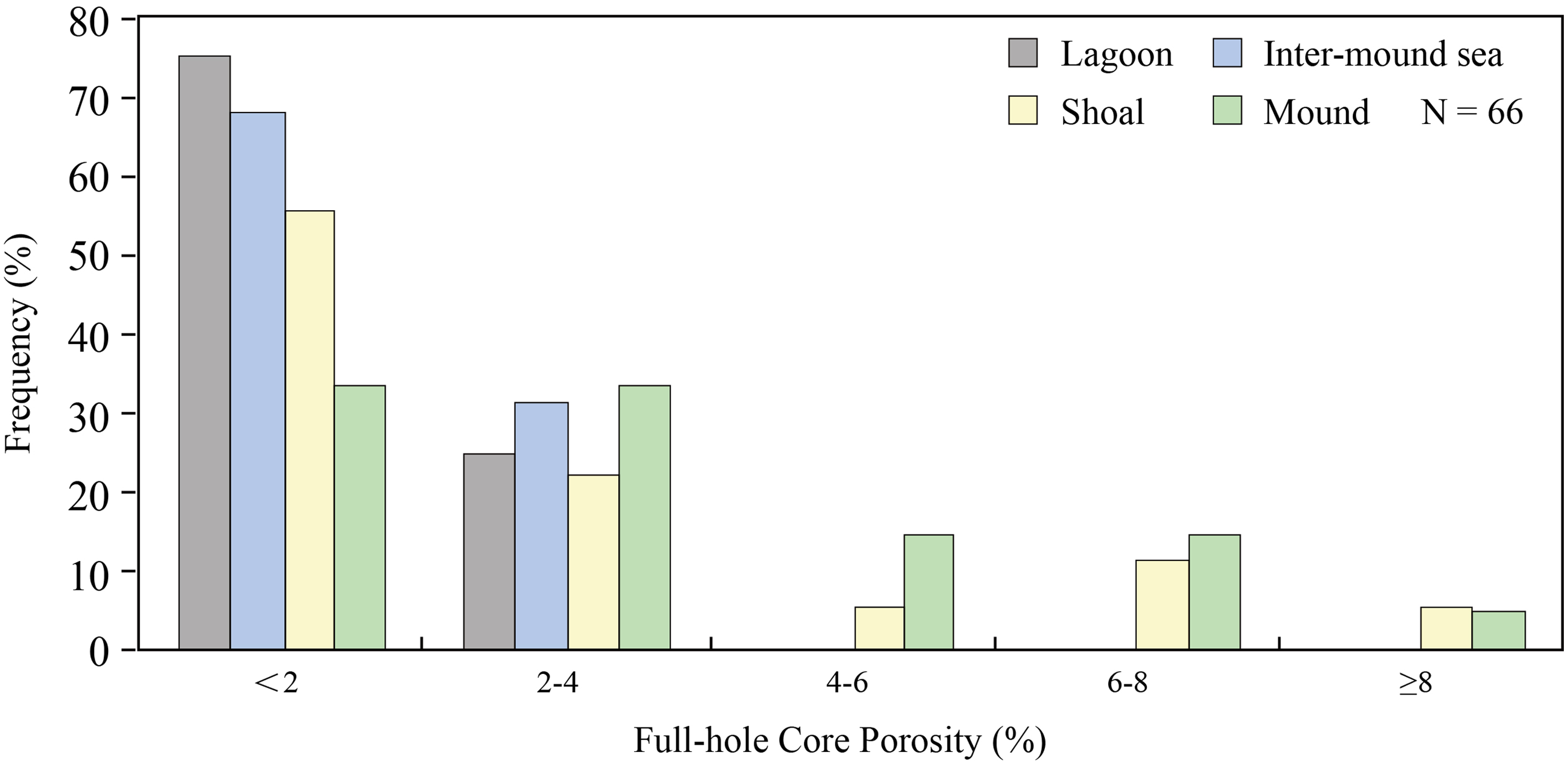
Histogram of the porosity of different sedimentary subfacies in the Central Sichuan Basin.
The distribution and development of mound-shoal complexes are also vital and related to potential eogenetic karst and reservoir formation. Mound-shoal complexes rim the platform margin, while some patch mounds and shoals are scattered across the inner platform. The complexes are obviously distributed wider in the north than in the middle and south (Figure 10(a)). The distribution density of vugs and the proportion of large vugs in the platform margin mound-shoal complexes evidently outnumber those of the inner platform (Figures 10(b) and (c)). At the platform margin, microbial and granular dolomites are the main reservoir-forming bedrocks. Dolomitic thrombolites, dolomitic stromatolites and dolarenites are the most favourable lithofacies (Figure 11), indicating strong control of the development and distribution of reservoir space by sedimentary and lithological facies. Microcrystalline dolomite also has a relatively high porosity (Figure 11).
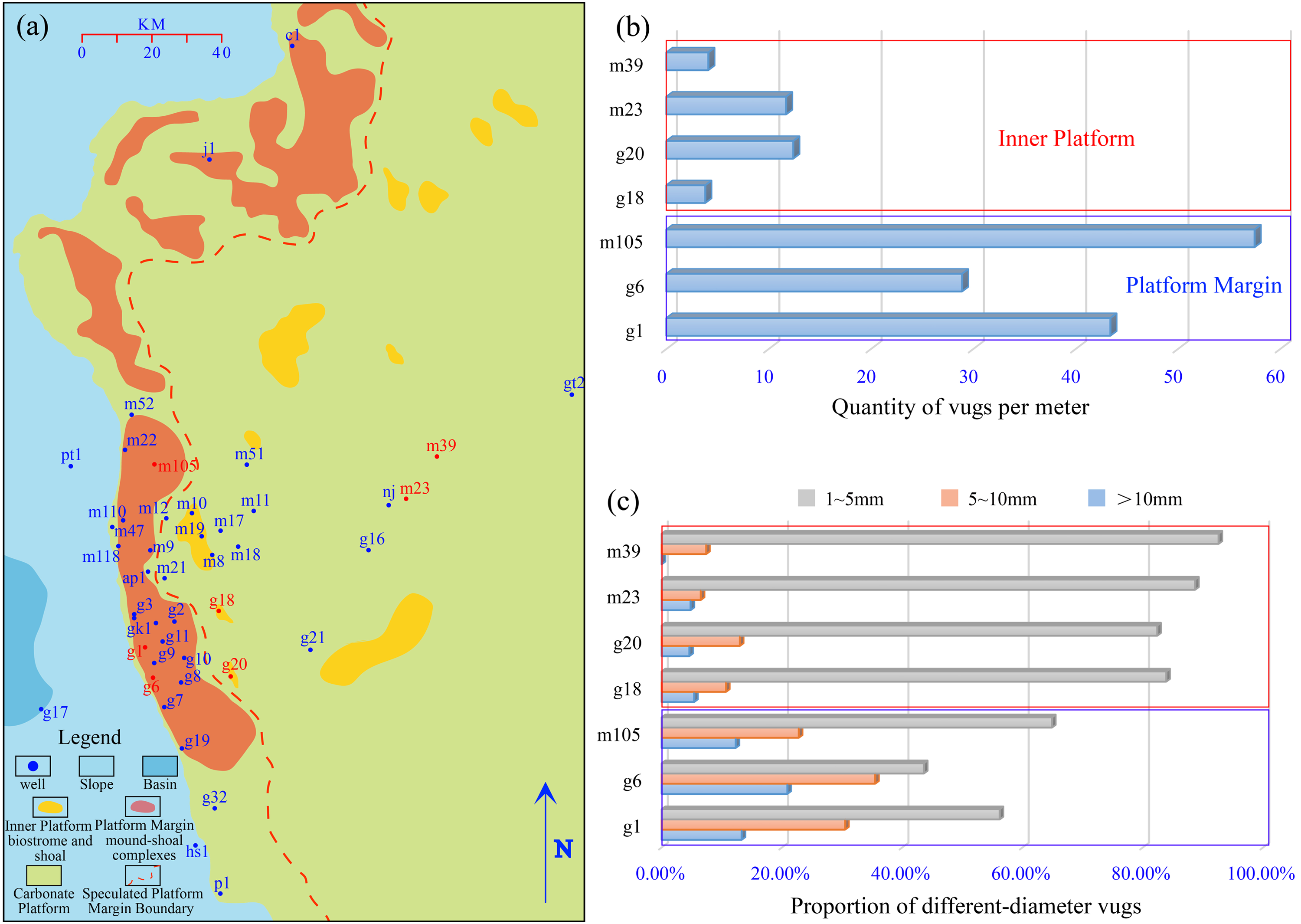
(a) Sedimentary facies distribution (modified from Xu et al., 2021). (b) Quantity of vugs per metre and (c) proportion of different-diameter vugs in single wells at the platform margin and inner platform (data cited from Tian et al., 2020).
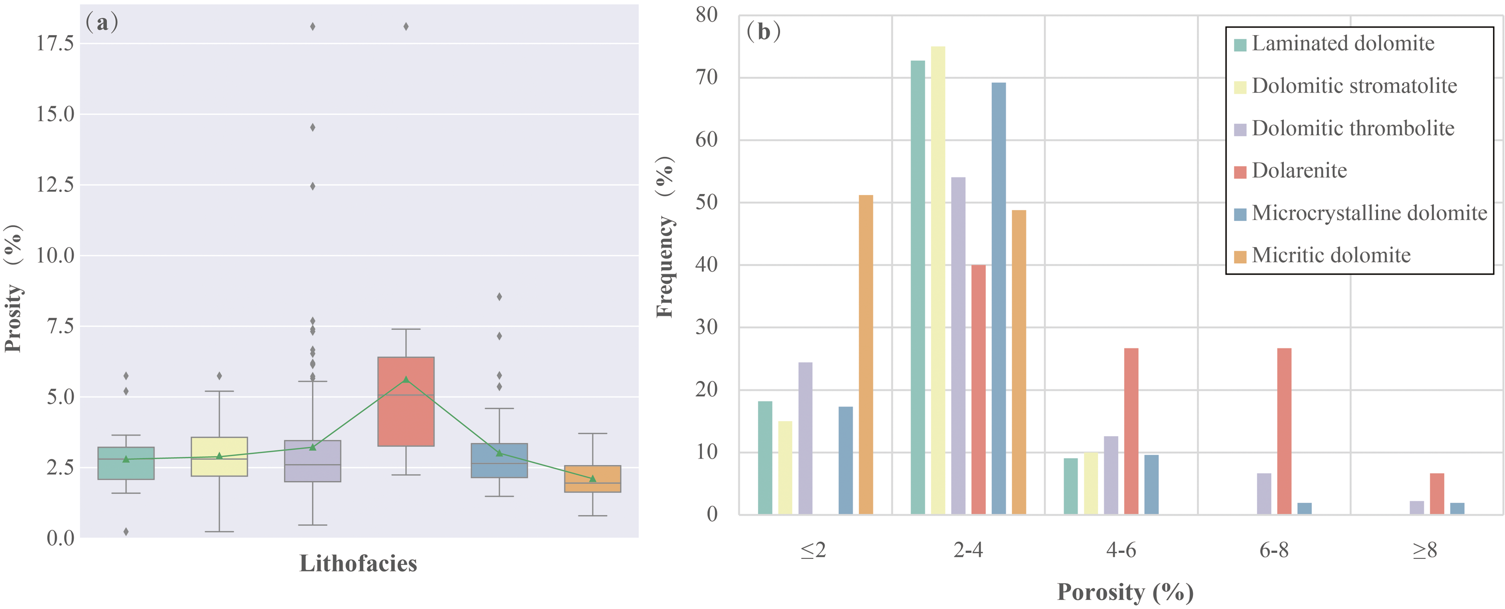
Porosity of different lithofacies. Grey diamonds in (a) indicate porosity outliers and green triangles represent the mean porosity of each lithofacies.
Control of palaeogeomorphology and karstification
The control of reservoirs by karst palaeogeomorphology is mostly embodied in dissolution mechanisms and patterns of different palaeogeomorphology units, which depend on differences in palaeohydrological conditions and materials. These eventually lead to differences in karstification intensity, giving rise to distinct types and developments of diverse palaeogeomorphology reservoirs.
Different palaeogeomorphological units possess diverse karst hydrodynamic conditions (Han et al., 2019). The recharge, runoff and discharge conditions of karst hydrodynamic systems also differ (White, 1988, 2002). Dissimilarities in diagenetic material affect the way karst water moves and, subsequently, the intensity and characteristics of karstification (Jin et al., 2020).
Considerable differences occur in hydraulic head, flow velocity, flow potential energy and flow occurrence, resulting in more intense dissolution and erosion on steep karst slopes that produce honeycomb-like vugs (Figure 12(a)), large crevices (Figures 12(b) and 13(a)) and laminoid vugs (Figures 12(c) and 13(b)), and solution collapse in dolomite breccias. Dissolution is so intense in steep slopes that the first-stage marine fibrous cements rarely preserved well. Framework voids of microbial rocks and other dissolution vugs are cemented by dolomites during the shallow burial stage and filled by solid bitumen residue in the subsequent hydrocarbon charging progress (Figure 14(a) and (b)). Also, there are ‘clean’ dissolution pores without bitumen (Figure 14(c)). Gentle karst slopes acting as transitions between erosional peneplains are formed by periodic base-level descent induced by enhanced stream incision on antecedent erosional peneplains. Karstification and erosion in gentle slopes are not as intense as in steep slopes, probably due to lower flow rates, weaker hydraulic potential and longer water retention times. However, the karst products do resemble those in steep slopes. Solution fractures (Figure 12(d)), crevices (Figures 12(e) and 13(c)) and small solution vugs (Figures 12(f) and 13(d)) are typical features in gentle slopes. Solution fractures are mostly filled by later-burial-stage dolomites, silica and solid bitumen (Figure 14(d)). Crevices are usually filled by mud, dolomites and vadose silts (Figure 14(e)). Although the overall gradients of gentle slopes are small, sophisticated solution pore-fracture systems can still form. Solution pores are more developed in gentle slopes than in peneplains and depressions. Marine cements in gentle slopes are rare and solid bitumen fillings are common (Figure 14(f)).
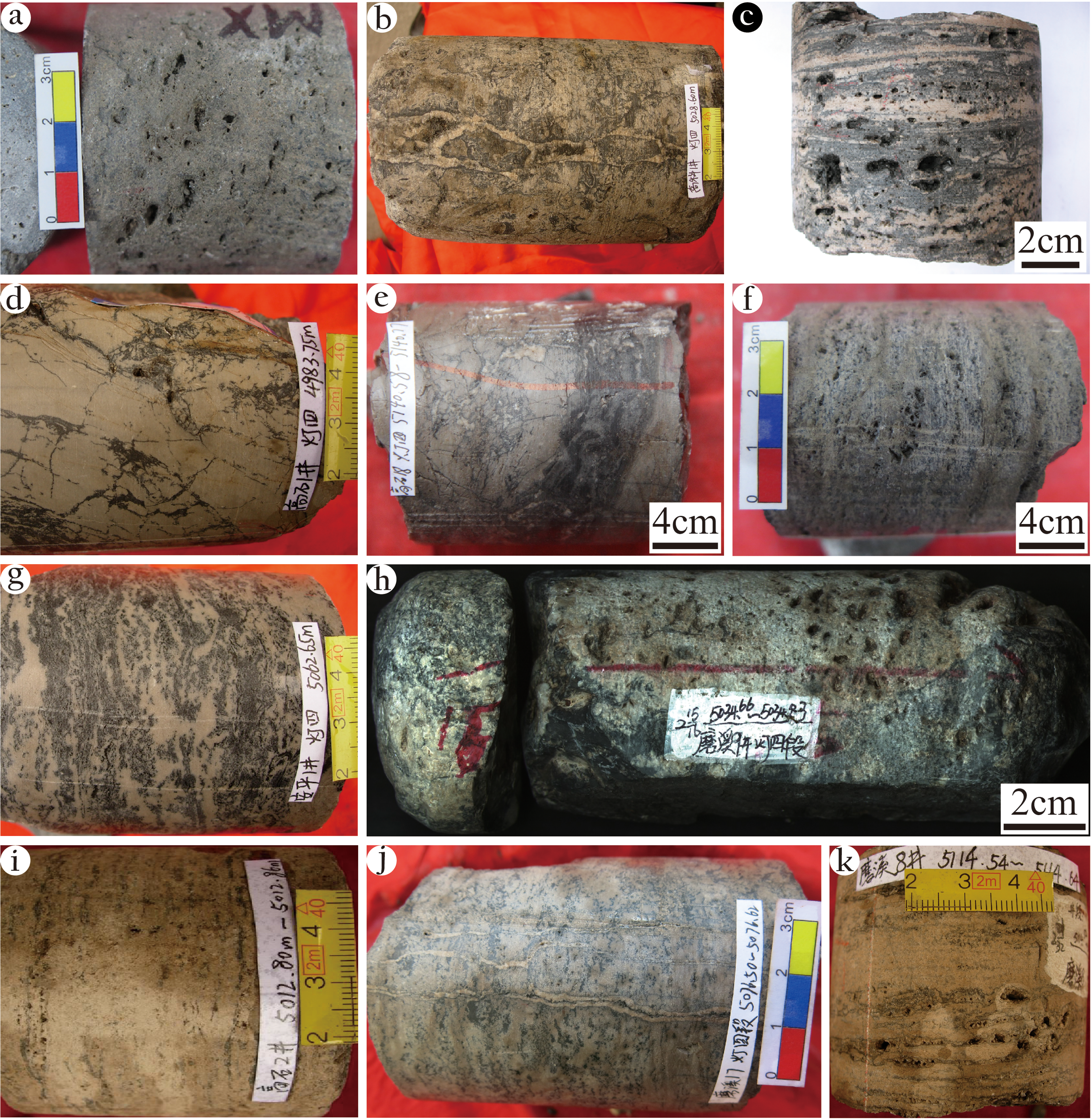
(a) Honeycomb-like vugs (from a steep karst slope; Well M109; elevation 5110.17 m). (b) Crevices, filled by broken bedrock, dolomite and argillite (steep karst slope; Well GK1; 5028.35 m). (c) Dissolution vugs, densely packed horizontally (steep karst slope; Well GK1; 5150.58 m). (d) Solution fractures and related dissolution-expanding vugs (gentle karst slope; Well G1; 4983.75 m). (e) Crevice, filled by mud, bitumen and other clay minerals (gentle karst slope; Well G18; 5140.58–5140.77 m). (f) Millimetric dissolution vugs, packed along laminae (gentle karst slope; Well G18; 5134.2 m). (g) Mottled karst feature, formed by infiltration and dissolution of eogenetic karst fluid and impregnation of bitumen in matrix porosities. The black mottles contrast with the bedrock distinctly (gentle karst slope; Well AP1; 5062.65 m). (h) Honeycomb-like dissolution vugs (peneplain; Well M9; 5034.66–5034.83 m). (i) Millimetric dissolution vugs, packed in laminae (peneplain; Well G2; 5012.8–5012.86 m). (j) Dissolution fractures (depression; Well M17; 5076.5–5076.62 m). (k) Millimetric dissolution vugs, packed along microbial laminae (depression; Well M8; 5114.54–5114.64 m).
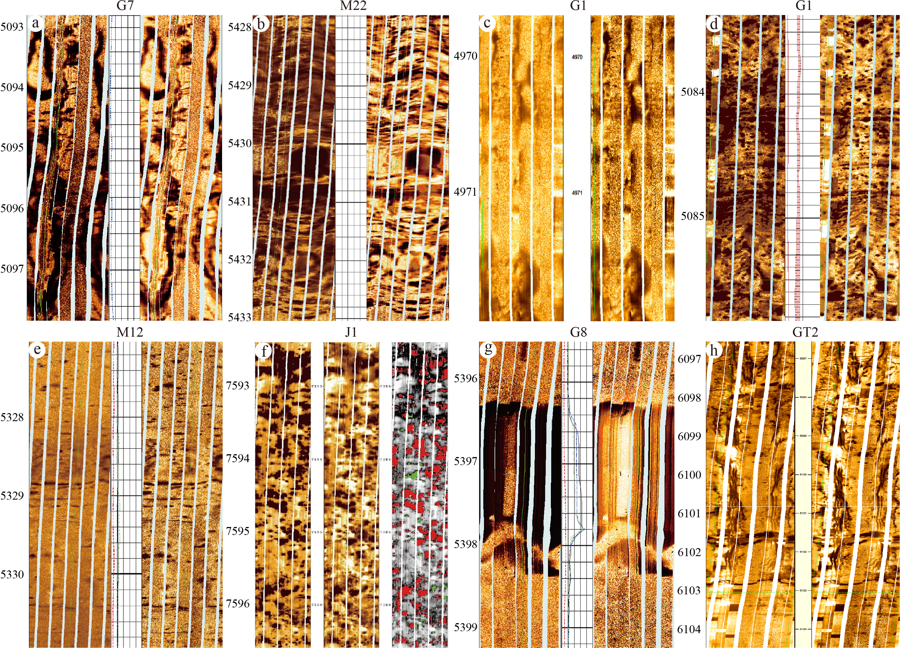
Fullbore Formation MicroImager (FMI) image features of karstification in different palaeogeomorphological units of the Z2dn4. (a) Crevice, presenting as a nearly symmetrical dark stripe (Well G7). (b) Dense laminoid vugs, packed along the layers, presenting as dark patches and ovals (Well M22). (c) Intermittent dark stripes, indicating small crevices (Well G1). (d) Honeycomb-like vugs, presenting as scattered dark spots (Well G1). (e) Sparse vugs, presenting as dark spots and fine lines (Well M12). (f) Very dense honeycomb-like vugs, presenting as irregular dark clots and patches. Note that the red clots stand for interconnected vugs and the green clots stand for isolated vugs (Well J1). (g) Metric-sized cave, presenting as the dark shaded interval in the image. Note that the light shaded area in the cave indicates breccias with high resistivity (Well G8). (h) Subvertical dissolution fractures, presenting as high-angle bent symmetric dark stripes (Well GT2). The dark shaded areas in FMI images indicate low electrical resistivity, whereas light shaded areas indicate high resistivity (denoting bedrock). The numbers denote well depths.
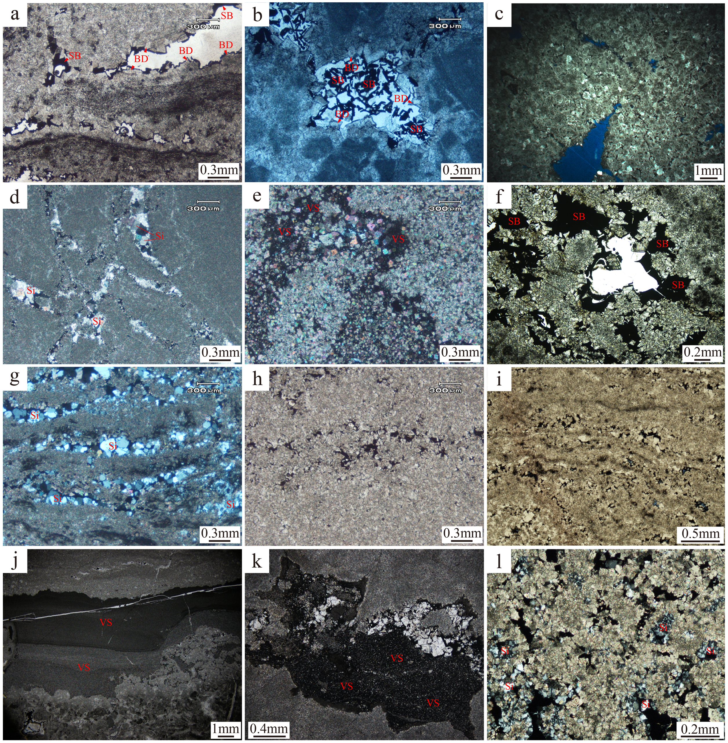
Microscopic karst features in different palaeogeomorphological units. (a) Dolomitic stromatolite, where framework voids are half-filled by bladed dolomite and solid bitumen; marine cements are absent (steep slope; Well GK1; 5149.58 m; plane-polarized light). (b) Microbial micritic dolomite, dissolution pores half-filled by solid bitumen and a few bladed dolomites (steep slope; Well GK1; 5145.1 m; plane-polarized light). (c) Dolarenite with dissolution pores rimmed by a few cement residuals (steep slope; Well M109; 5107.43 m; plane-polarized light). (d) Microbial micritic dolostone; bedrock separated by solution fractures presenting the peculiarity of pseudo-breccia; solution fractures are filled by micro-to-fine-crystalline dolomite, silica and solid bitumen (gentle slope; Well G1; 4987 m; cross-polarized light). (e) Micro-to-fine-crystalline dolostone; the crevice is filled by vadose silts (gentle slope; Well G1; 4966.06 m; cross-polarized light). (f) Micritic to micro-crystalline dolostone; solution pores are interconnected by extremely fine throats and are half-filled by certain residual dolomite cements and solid bitumen (gentle slope; Well G18; 5134.64 m; plane-polarized light). (g) Dolomitic stromatolite; laminae-parallel dissolution vugs are filled by silica (peneplain; Well AP1; 5062 m; cross-polarized light). (h) Coarse crystalline dolostone; bedding-parallel dissolution pores are filled by fine-crystalline dolomite and solid bitumen (peneplain; well AP1; 5053 m; plane-polarized light). (i) Dolomitic stromatolite; developed laminae-parallel dissolution pores are filled by fine-crystalline dolomite and solid bitumen, while a few isolated pores remain unfilled (peneplain; Well G2; 5013.99 m; plane-polarized light). (j) Granular boundstone; the crevice is filled by one darker and one lighter layer of vadose silts (depression; Well M17; 5067 m; plane-polarized light). (k) Micritic-to-micro-crystalline dolostone; the void is filled by the middle-lower vadose silts and the upper fine-to-meso-crystalline dolomites, presenting as geopetal fabric (depression; Well M17; 5077.4 m; plane-polarized light). (l) Coarse crystalline dolostone; dolomites are replaced by silica and the irregular dissolution pores are filled by silica and solid bitumen (depression; Well M8; 5156.13 m; cross-polarized light).
In the erosion cycle, land uplifted above sea level is eventually eroded to close to the erosional datum plane, and peneplain morphology progressively appears and approaches sea level during this process (Ford and Williams, 2007). The erosional peneplain presents as flat terrain with gradients <0.2° bounded by a series of slopes. A stepped geomorphology consisting of peneplains and gentle slopes indicates a pulsing and descending process of multistage erosion. A lack of hydraulic potential associated with flat terrain and long distances from discharging areas lead to weak incision, making peneplains major runoff areas. Karst fluids generally move horizontally although some move downward and percolate through structural fractures or the matrix pores of porous dolomites locally, forming a typical mottled dissolution system (Figure 12(g)), relatively sparse vugs (Figure 12(h)) and millimetric vugs arranged horizontally (Figures 12(i) and 13(e)). The solution fractures in peneplains are less developed. First-stage marine cements are almost absent and many of the open and interconnected porosities are frequently hatched by silica (Figure 14(g)) and solid bitumen (Figures 14(h) and (j)), such that the effective porosity is reduced.
Monadnocks are residual mound landforms that have not been eroded to the erosional datum plane in a peneplain. They have a side slope that is generally <20° and a shape generated by stream incision. The height difference between the top and the base does not exceed 200 m. The side slopes of monadnocks are comparable to slopes. They are repeatedly eroded by water flow and possess the characteristics of a large (centimetric-decimetric) karst vuggy system (Figure 13(f)) and metric-sized cave (Figure 13(g)). Although there are no drilling data, karst characteristics and dome products can be inferred from their analogues, scilicet karst gentle slopes and monadnocks, because domes, monadnocks and gentle slopes are all characterized by slopes (Table 1). Yet, domes are located almost entirely in inner platforms, the lithofacies of which differ from the monadnocks at platform margins. Accordingly, the karst products of domes should be analogous to those of gentle karst slopes situated at inner platforms.
A depression is a local or regional discharging area receiving runoff and groundwater from the surrounding elevated area. It has side slopes that are commonly <0.5° and are a type of sunken terrain, in contrast to monadnocks. Erosion and dissolution of karst water passing through the erosional peneplains and slopes make the karst water itself reach saturation and then slow down to gradually gather and precipitate in depressions. Dissolution fractures and millimetric pores can be found in the cores (Figure 12(j)). Somewhat millimetric dissolution vugs (Figure 12(k)) can form in microbial laminae, dolomitic stromatolites and clots under a greater gradient, while karstification in rocks without microbial components is not very developed. Depressions are dominated by carbonate and even siliceous cementation and precipitation, with fewer and less developed pores (Figure 13(h)) and a high pore-filling degree. Vadose silts are preserved well (Figure 14(j)) in depressions due to their low-lying terrain. Certain pores are filled by vadose silts and dolomite cements form geopetal fabrics (Figure 14(k)). Developed dissolution pores can be found in some favourable lithofacies of depression side slopes but are basically filled by dolomite, silica and solid bitumen (Figure 14(l)).
According to logging data and based on the principles of karst hydrogeology, Figure 14 was plotted to show the hydrological and hydraulic conditions of two cross-sections of Central Sichuan Basin (Figure 15). Discharge of groundwater is mainly diffused towards the north and west by gravity, which is consistent with the major dip direction of the slopes according to the palaeogeomorphology. Vadose and upper phreatic zones are the most developed and deep phreatic zones can only be found in the north of the basin, while epikarst zones are rare. Metric-sized caves are well developed in the vadose and upper phreatic zones, indicating prolonged karstification and sufficient recharge. Vugs are predominantly distributed in the vadose zone and upper part of the upper vadose zone, which are adjacent to the western steep slope, implying lithological and karstification differences between the platform margin and interior. Fractures are distributed relatively randomly but sloping terrain is more developed, which may reveal an influence of gradient on fractures, especially vadose fractures and crevices.
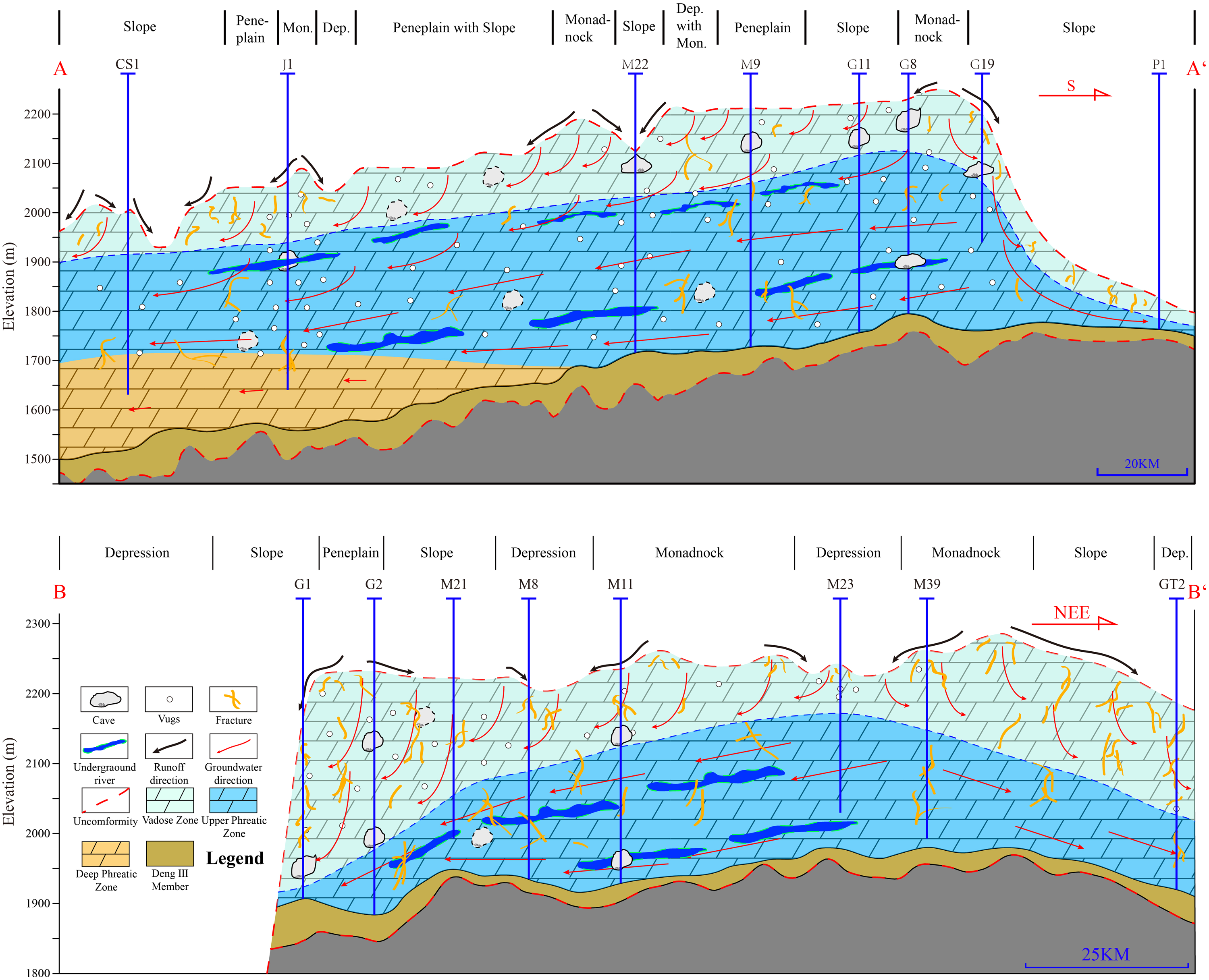
Hydrological conditions of the Z2dn4 of the Central Sichuan Basin. For the profile location, see Figure 5.
Reservoirs are most developed in steep karst slopes where erosion and karstification are rather intense. The reservoir physical parameters, gas testing productivities, reservoir thickness and slope gradients of boreholes in the Z2dn4 are listed in Table 2. In the ten boreholes on steep slopes, the average porosity is 2.79%, the average permeability is 0.294 mD, the average gas testing productivity is 78.88 × 10⁴ m3/d, the average reservoir thickness is 162.7 m, and the average gradient is approximately 2.03°. The main reservoir volumes on the steep slope are centimetric-decimetric vugs (Figures 12(a), (b), (d) and 13(b)). In the nine boreholes on gentle slopes, the average porosity is 2.08%, the average permeability is 0.482 mD, the average gas testing productivity is 17.56 × 10⁴ m3/d, the average reservoir thickness is 73.2 m, and the average gradient is approximately 0.58°. The average permeability of gentle slopes is higher than that of steep slopes, which seems implausible. The lack of permeability data for steep slopes may explain this.
Statistics of reservoir capabilities, gas testing productivities and gradients in different palaeogeomorphological units.
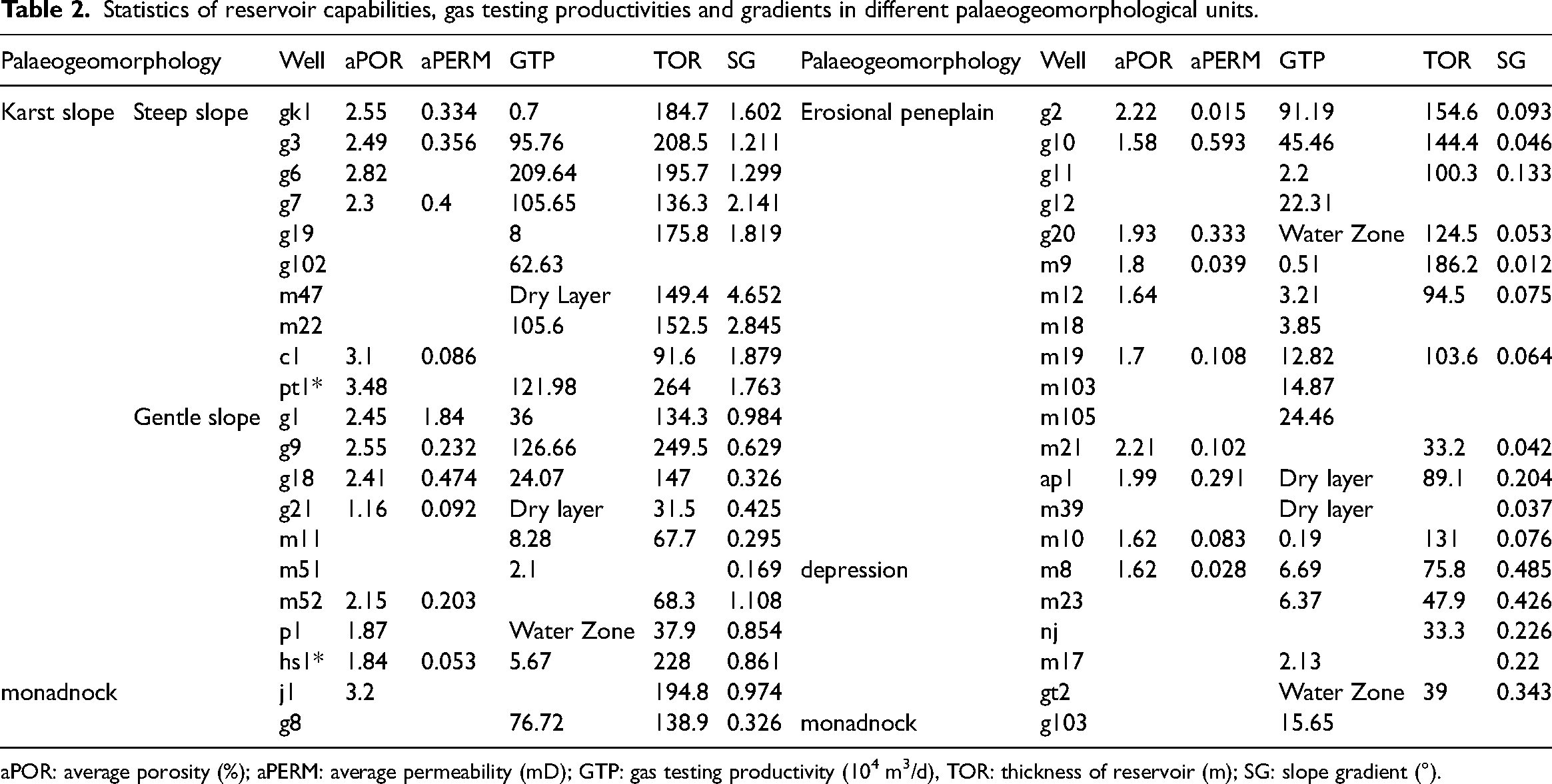
aPOR: average porosity (%); aPERM: average permeability (mD); GTP: gas testing productivity (104 m3/d), TOR: thickness of reservoir (m); SG: slope gradient (°).
The karst water incisions on erosional peneplains are relatively weak. Reservoir volumes lack large vugs and predominantly have millimetric vugs (Figures 12(f) and 13(e)). Porosity diameter and vugs’ density are distinctly minor and lower than those of the slopes. The statistics of 15 boreholes on the erosional peneplains show that the average porosity is 1.85%, the average permeability is 0.196 mD, the average gas testing productivity is 15.71 × 10⁴ m3/d (which approaches that of gentle karst slopes), the average reservoir thickness is 116.1 m, and the average gradient is only 0.08°.
There are only three boreholes drilled through monadnocks. Nevertheless, the average gas testing productivity of these three wells was 46.19 × 10⁴ m3/d and the average reservoir thickness was 166.9 m. Among the three wells, well J1 had truly well-developed karst vugs (Figure 13(f)), while well G8 had metric-sized caves (Figure 13(g)). The average porosity was 3.2%, which is greater than those of the erosional peneplains and gentle slopes.
In the classical evolution pattern of karst geomorphology, depressions can be regarded as the onset of a new peneplain. However, the remnant depressions surrounded by peneplains (Figures 7 and 8) ceased in the process of forming next-stage peneplains. Packed dolines may be developed in the flat bottoms of depressions, leading to their collapse to form breccias and mechanical stowing. As a regional discharging area, large amounts of mechanical stowing brought by frequent karst fluids may block the porosities and prevent further karstification; thus, reservoir volumes may not be developed. The porosity of the depression in well M8 was only 1.62% and its average permeability was just 0.028 mD. The average gas testing productivity of the five wells was 5.06 × 10⁴ m3/d, the average reservoir thickness was only 49 m, and the average slope was 0.34°.
Slopes have clearly higher porosity than peneplains and depressions, which may be due to sedimentary and lithological differences. Yet, the permeability of the palaeogeomorphological units still differed distinctly, even undergoing burial alterations and structural modifications for hundreds of million years. Karstification impacts are non-negligible in causing permeability differences amongst the palaeogeomorphological units. Pores are less interconnected and their throats are occluded by multi-stage pore fillings like dolomites, silica and bitumen (Figures 14(b), (f)-(i) and (l)); hence, fractures and vugs are now the main providers of permeability. Hydrological and hydrodynamic differences between palaeogeomorphological units notably influence the development of dissolution fractures and vugs created by karstification, provoking differential development and permeability of dissolution fractures and vugs among slopes, peneplains, monadnocks and depressions. Dissolution fractures and vugs are more developed in slopes than other units and their permeability is also greater, which can be ascribed to greater hydraulic head differences and more intense incision and erosion of karst fluids.
From the perspective of their contributions to reservoirs, the units can be ranked in order as: steep slope, monadnock, gentle slope, erosional peneplain, and depression. Diverse palaeogeomorphological units vary greatly in porosity, permeability and gas testing productivity, affecting the development of reservoirs by controlling the intensity of dissolution and erosion.
Between the vicinity of the steep karst slope and the inner platform, the reservoir qualities of the Z2dn4 become progressively poorer. The scope of eogenetic karstification differs as a consequence of karst hydrodynamics and fluid properties. Reservoirs in steep karst slopes and their vicinities develop throughout the member, while an overwhelming majority of those in the inner platform is distributed simply in the middle and upper parts of the Z2dn4, which has typical eogenetic karst features (Figure 16).
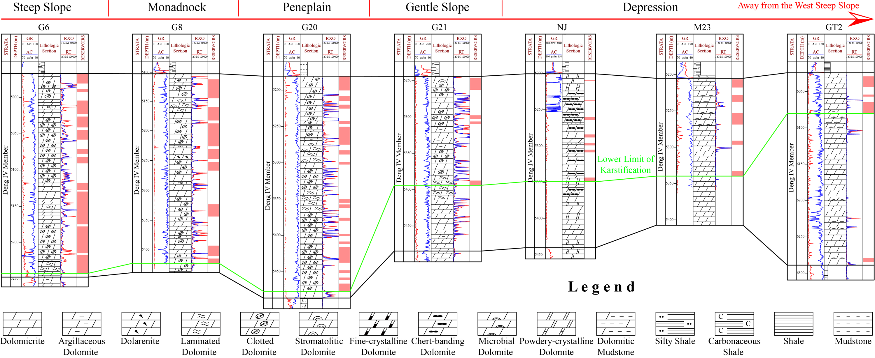
Reservoir correlations of wells selected from different palaeogeomorphological units. The number and total thickness of reservoirs tend to gradually decrease with increasing distance from the western steep slope. The bottom boundary of a reservoir can indicate the lower limit of karstification (shown by the green line). Vertical differences in reservoir development in the wells imply differences in karstification type and intensity. For the profile location, see the black line in Figure 5.
Impact of palaeogeomorphology on hydrocarbon accumulation
The natural gas in the Z2dn in Central Sichuan Basin is derived from different source rocks (Zheng et al., 2021). Some geochemical proxies were used to analyse the gas-source correlations. A rhenium–osmium isotopic geochronometer applied to the study of solid bitumen in the Z2dn in the Ziyang-Weiyuan area showed Re–Os isochron ages of 414 ± 44 Ma with an initial 187Os/188Os (Osi) of 1.36 ± 0.19. This indicates that the oil generation timing was in the Early Devonian, which is consistent with the range of 187Os/188Os values of the Є1q (Shi et al., 2020a). U-Pb isotopic ages and clumped isotopic (Δ47) temperatures of fine-medium crystalline dolomite cements and hydrocarbon inclusions that were contemporaneous with hydrocarbon generation in the Central Sichuan Basin yielded an age of 416 ± 23 Ma and temperature of 84–120 °C. Meanwhile, the burial depth of Є1q was 1000 m shallower than that of Z2dn, leading to lower temperatures of 70–100 °C that already exceeded the hydrocarbon generation threshold (Shen et al., 2021). Mn/Fe ratios and a 10Mn-Fe-P ternary diagram of bitumen from Z2dn and possible source members exhibited the best affinity between the Z2dn and Є1q in the Ziyang-weiyuan area (Shi et al., 2020b). The compositions and contents of hydrocarbon gases in the Central Sichuan Basin are similar to those of the adjacent Ziyang-weiyuan area but with higher CO2 and lower N2 concentrations, while the δ13C2 value in the Central Sichuan Basin is evidently higher, indicating the genesis of deep carbonate metamorphism and thermochemical sulfate reduction (Zheng et al., 2021). Bitumen biomarkers were characterized by the similarity of the high C29 sterane abundances of mudstone from Є1q and microbial dolomite from Z2dn. The sterane distribution of reservoir bitumen in the Z2dn resembles that of source rocks in both the Є1q and Z2dn. All of this evidence suggests that the hydrocarbons in reservoirs were derived from mud-shale of the Є1q and microbial dolomite from Z2dn (Zheng et al., 2021). Thus, the main source origin of the Z2dn in both the Central Sichuan Basin and neighbouring Ziyang-weiyuan area is mud-shale of the Cambrian Є1q.
Shale of the Є1q in Sichuan Basin is with high TOC content of 1.85 wt% (Total Organic Carbon) and Ro of 2.53% (vitrinite reflectance) on average (Li et al., 2021). The established hydrocarbon generation and expulsion model indicates the maximum of generation intensity for shales of the Є1q nowadays reaches 32 × 106 t/km2, and that the maximum of expulsion intensity is 18 × 106 t/km2, suggesting the huge and excellent hydrocarbon generation and expulsion potential of shales of the Є1q (Li et al., 2021). And negative δ13Corg values in the bottom section of the Є1q is −32.91 ‰ on average, showing a high degree of anoxia of ambient waters (Wang et al., 2015). Whereas in the top section of the Є1q, the negative δ13Corg values are higher, implying a l dysoxic–oxic sedimentary circumstance (Gao et al., 2021; Wang et al., 2020). This may illustrate the environmental variation through whole piling-up process of the Є1q. In the duration of transgression immediately after the eogenetic karstification, subjecting to the karst landform, the deep-water shelf attained a greater quantity of organic-matter-bearing sediments than the shallow-water shelf; not only because of the larger depositional thickness, but also due to nutrients from hydrothermal upwelling, that made the primary productivity higher; and that the anoxic surroundings favoured preservation of these organic matters in deep-water shales (Li et al., 2022). All these come to that the hydrocarbon generation potential is higher in deep-water shelf than in the shallow-water shelf. Hence, shale of the Є1q in Mianyang-changning intracratonic sag (deep-water shelf) is indeed the better source rock for the Z2dn4 with remarkable hydrocarbon-generating potential than that of the shallow-water shelf overlying the Z2dn4.
The organic-rich shale of the lower Cambrian Є1q in the Central Sichuan Basin is the major hydrocarbon source of the underlying Z2dn4 (Zheng et al., 2021; Zeng and Guo, 2015). Its sediment is thick, particularly combined with the residual Є1m in the Mianyang–Changning Intracratonic Sag in the west, which constitutes the regional hydrocarbon generation centre where the overall thickness of source rocks exceeds 400 m (Figure 17). Dark shale and siltstone of the Deng III member subjacent to the Z2dn4 have the potential for hydrocarbon generation. Therefore, the Z2dn4 in the Central Sichuan Basin is encircled by source rocks on three sides and has the characteristics of ‘upper generation and lower accumulation’, ‘side generation and lateral accumulation’ and ‘lower generation and upper accumulation’.
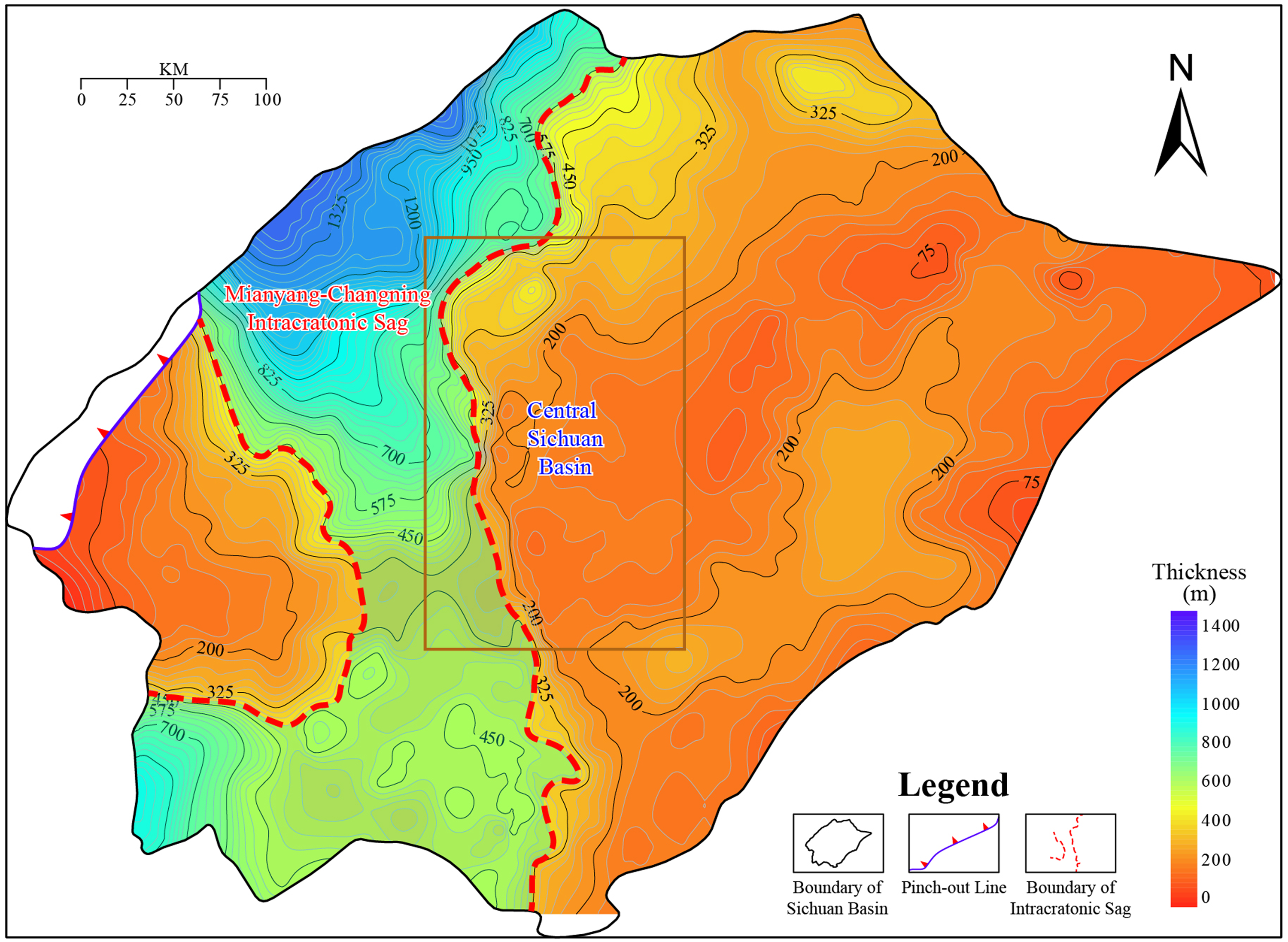
Source rock thickness variation in the Є1m and Є1q in the Sichuan Basin. Note that the thickest source rock region lies in the Mianyang-Changning intracranial sag, which is adjacent to the Central Sichuan Basin.
In the ‘upper generation and lower accumulation’ pattern, the conditions required for downward migration of hydrocarbons in overlying source rocks are not easily met. Only when the overlying source sequence pressure surpasses that of the underlying reservoirs are oil and gas driven downward (Cong et al., 2016; Fu et al., 2017). Therefore, reservoirs formed by a downward migration pattern are generally small in scale.
In contrast, the ‘side generation and lateral accumulation’ and ‘lower generation and upper accumulation’ patterns accord with the principles of hydrocarbon migration. The thicker source rocks in the western part of the steep karst slope supply substantial hydrocarbons that continue to move upward along the slope to the inner platform, passing through a monadnock, erosional peneplain and gentle slope. The migrating capability of the hydrocarbons decreases with increasing distance (due to friction, capillary pressure, etc.). This leads to more hydrocarbons being entrapped in the steep karst slope belt and adjacent areas than in the inner platform (Song et al., 2021). Surely, the heterogeneity of the primary and karst vugs of the platform margin and interior also hinders hydrocarbon migration. Due to sealing and blocking by the mudstone and shale of the overlying Є1q and the impact of intra-reservoir heterogeneity, hydrocarbons first accumulate on the steep karst slope and in its vicinity (especially in high areas such as monadnocks), with more developed karst vugs occurring in the course of subsequent oil and gas charging. However, in the erosional peneplain, gentle karst slope and dome in the inner platform, only a small quantity of oil and gas accumulates in local high areas. Hydrocarbons in depressions escape with ease, such that beneficial oil and gas reservoirs do not form readily (Figure 18).
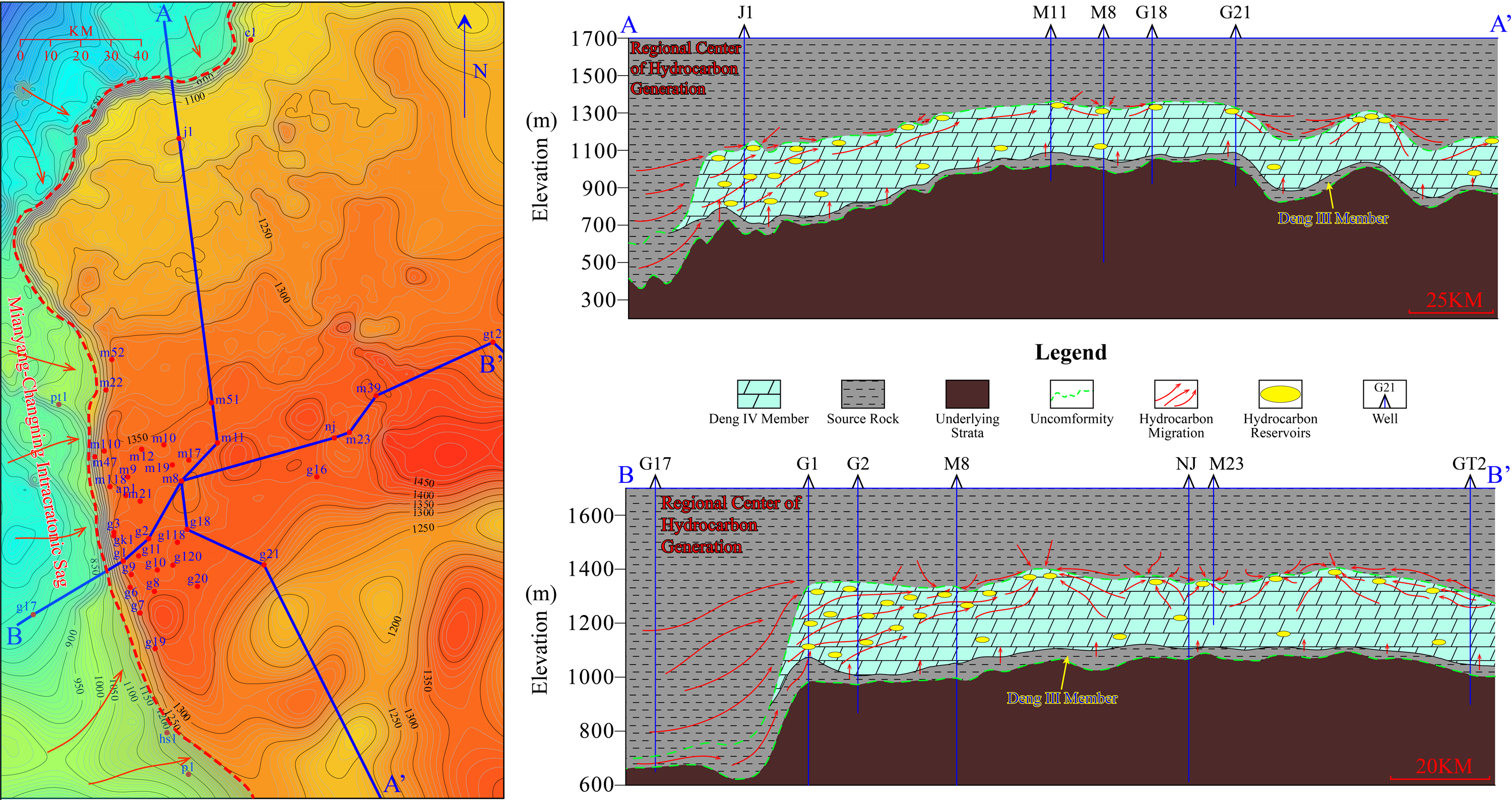
Hydrocarbon migration and accumulation in the Z2dn4 in the Central Sichuan Basin. Hydrocarbons in this basin are predominately generated in the regional centre of hydrocarbon generation, which has thicker source rocks, and migrate laterally to the porous dolomites in the adjacent Z2dn4. Only a small number of hydrocarbons impregnate and migrate to the Z2dn4 from the overlying and underlying source rocks.
Conclusions
The palaeogeomorphology of the top of the Sinian strata in the Central Sichuan Basin was reconstructed by using the elevation method. In light of morphology, distribution range, calculation of gradients and palaeohydrological conditions, the reconstructed palaeogeomorphology is divided into karst slopes, erosional peneplains, monadnocks, domes and depressions. And karst slopes can be further subdivided into gentle slopes (<1.2°) and steep slopes (> 1.2°).
Giving the credit to the most intense karst hydrodynamics, stream incision, mixing-water karstification involving with fresh water and seawater, the steep karst slope and its vicinities (including part of peneplain, gentle slopes and monadnocks), which are characterized by much developed large-scale honeycomb-like and laminoid vugs, bear the most developed reservoirs of the Central Sichuan Basin. And that the platform margin, with more porous mound-shoal complexes, is superimposed with the steep karst slope and its vicinities. This fact endowed the steep karst slope and its vicinities with excellent diagenetic foundation for both the after eogenetic and burial karstifications. In addition, abuttal of the steep karst slope and its vicinities to the regional hydrocarbon generation centre made it apt for oil and gas to be accumulated and trapped preferentially.
With respect to the other palaeogeomorphological units, reservoirs of which are less developed for the inadequacy of efficient porosity and permeability brought about by the prevailingly and dominantly non-advantageous lithofacies such as micritic dolomite, for the comparative weakness of karstification with sole fresh water recharge and limited initial seepage and flow channels ascribing to the less porous lithofacies, for the small amount of oil and gas charging imputing to the farness from the regional hydrocarbon-generating centre. It follows that steep karst slope and its vicinities should be considered the most favourable exploration targets.
Footnotes
Acknowledgements
The authors thank the Exploration and Development Research Institute of PetroChina Southwest Oil and Gas Field for their support, plentiful data and permission to use and publish that data. Special thanks are extended to Dr Wang Wenzhi and Dr Huang Zisang for their enlightening and insightful suggestions and help, which have made this paper better.
Authors contribution
X.Y., F.H. and S.P.: Investigation. X.W. and Y.Y.: Project administration. W.W. and H.Z.: Resources. L.W.: Supervision. Z.Z.: Writing – original draft. All authors have read and agreed to the published version of the manuscript.
Declaration of conflicting interests
The author(s) declared no potential conflicts of interest with respect to the research, authorship, and/or publication of this article.
Funding
The author(s) disclosed receipt of the following financial support for the research, authorship, and/or publication of this article: This work was supported by the Major Science and Technology Project of PetroChina Co., Ltd., National Science and Technology Major Project (grant number 2016E-0602, 2016ZX05004-005).