
Abstract
Eastern Ordos Basin is an important region for the development of Carboniferous-Permian coalbed methane in China; however, there are significant differences of the coalbed methane exploration and development prospects among different regions within eastern Ordos Basin due to the multiple tectonic movements. In this study, the No. 5 coal of the Shanxi Formation of the Lower Permian in the Daning-Jixian region was selected for analysis. The influences of structures on coalbed methane content and permeability of coalbed methane reservoirs in the Daning-Jixian region were discussed and the favorable target areas for coalbed methane development were determined based on the analysis of tectonic characteristics and evolution. The results indicate that the main structures in this region extend in the NE–NNE direction with distinct E-W-trending zoning, which can be specifically divided into, from the east to the west, the fault depression zone in basin margins, the gentle fold zone in basin slopes, and the gentle slope zone. The formation and evolution of the structures in this area are primarily formed during the Indosinian, the Yanshanian, and the Himalayan movement, and the tectonic movement during the Middle Yanshan Period is critical for the formation of the structural frameworks. The coalbed methane contents in the No. 5 coal increase from the east to the west; therefore, low gas contents are found in the eastern margin zone, while the Yaoqu-Wucheng zone of middle slope belt displays high coalbed methane contents. The permeability is relatively high in the eastern margin zone and in the Mingti-Yangjiahe region of the middle slope zone, where there exist relatively strong structural deformations. The Guyi and Mingzhu blocks are selected as the favorable target areas for coalbed methane exploitation by a comprehensive analysis of burial depth, coalbed methane content, and the permeability.
Keywords
Introduction
The Ordos Basin is a large coal industry base with many large natural gas fields, high oil reserves, and productions. In addition, the coalbed methane (CBM) resources of the Ordos Basin account for one-third of China’s total CBM resources, showing great development potential (Feng et al., 2002). Recently, the basin evolution process and its corresponding accumulations of multi-resources have attracted increasing interests of geologists (Liu et al., 2006). To date, the Ordos Basin is one of the hot spots in the exploration and development of CBM in China, and the Carboniferous-Permian CBM development is mainly concentrated within the eastern margin. The eastern margin is a complex tectonic, geomorphic boundary zone, separating the western Ordos block from the eastern Shanxi fault uplift. The CBM formation process was influenced by tectonic deformations (Jiang et al., 2010). Tectonic patterns with different properties and types not only control the morphology, continuity, and permeability of coal seams (Bachu and Michael, 2003; Pashin, 2010; Qin et al., 2014), but also impact the generation, migration, and preservation of the CBM (Jiang et al., 2005). In this study, the No. 5 coal of the Shanxi Formation of the Lower Permian in the Daning-Jixian region was taken as the sample. Based on the analysis of the tectonic characteristics and evolution, the influences of tectonics on CBM content and the permeability of coal reservoirs were discussed, and the favorable target areas for CBM development were confirmed.
Geological setting
The Daning-Jixian block, located in the south part of eastern Ordos Basin, is an important CBM development area in China, which is bounded by the Zijingshan Fault (the south part of Zijingshan Fault) to the east (Liao et al., 2007) and the Yellow River to the west. It is part of the south of the Jinxi fold belt, which lies in eastern Ordos Basin. The main tectonic trending is arcuate and protrudes to the east, which is nearly N-S oriented in the north part, and gradually transforms to the NNE–NE in the south (Figure 1). The strata in the study area are in line with the typical formations of North China, and the exposed strata are successively (from the older to the younger): Cambrian, Ordovician, Carboniferous, Permian, Triassic, Neogene, and Quaternary systems. The Taiyuan Formation of the Upper Carboniferous–the lower Permian and the Shanxi Formation of the lower Permian are the main coal bearing strata. The Taiyuan Formation could be found in the whole area and is continuously deposited after the Benxi Formation of the Upper Carboniferous. The Shanxi Formation is furtherly integrated over the Taiyuan Formation and these two formations totally contain 10 coal seams, among which the No. 5 coal of the Shanxi Formation and the No. 8 coal of the Taiyuan Formation, with the larger coal seam thick and the higher CBM contents, are the main targeted coal seams for CBM exploration.
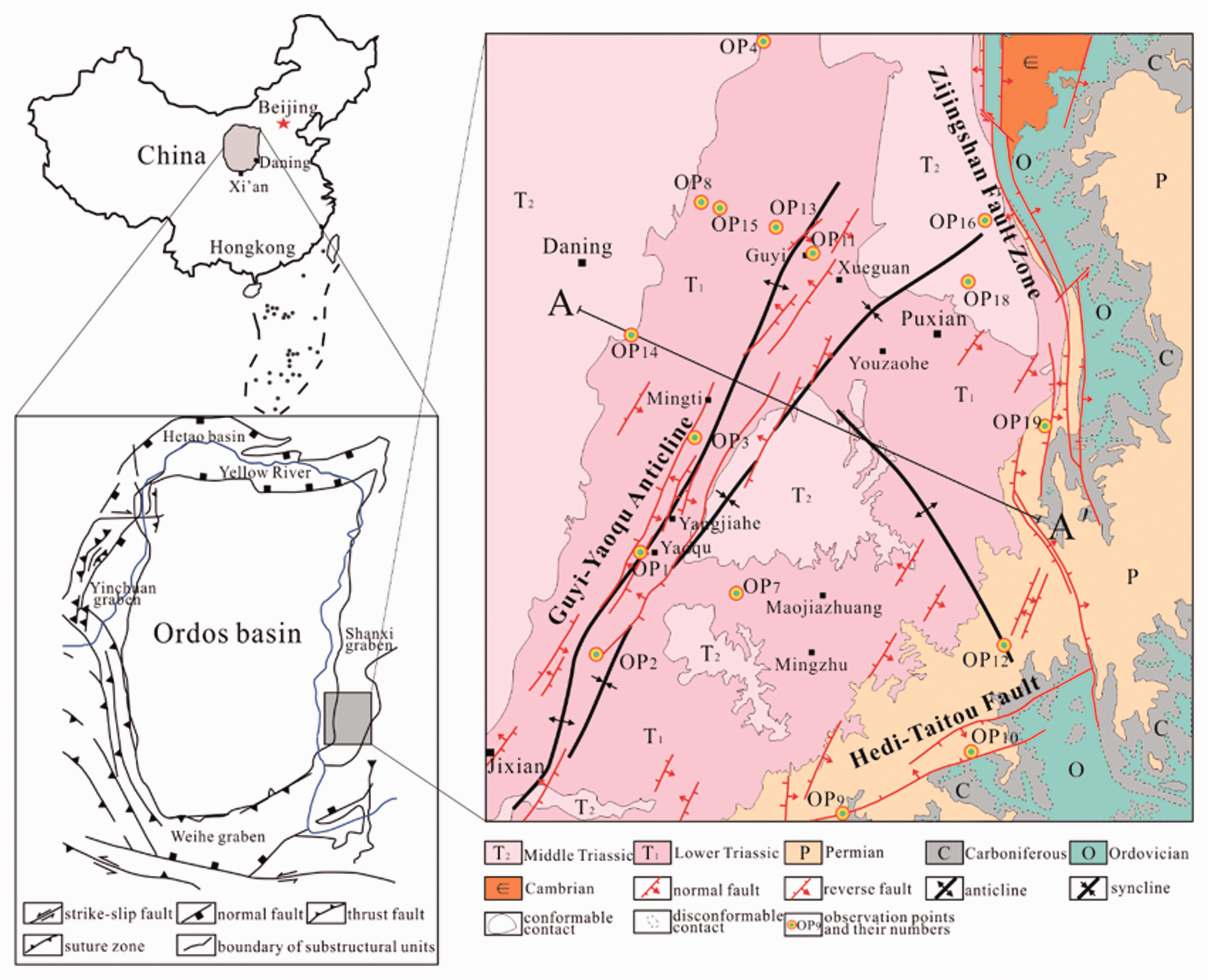
Tectonic position and structural outline of the Daning-Jixian region.
Characteristics of tectonic deformation and its evolution
Due to the multi-stage tectonic stresses, a certain degree of tectonic deformation has been formed in the study area. The faults are mainly distributed in the eastern margin zone and dominated by thrusts. And all the faults distributed within this area are relatively weak. In addition, the folds observed are mainly the broad type, and flexure structures could be partially observed. Based on the detailed field geological observations in the Daning-Jixian region, the characteristics of tectonic deformation and its evolutions were furtherly discussed.
Tectonic zoning and deformation characteristics
Characteristics of tectonic zoning
The main structure in the Daning-Jixian region is mainly a monocline extending in the NE–NNE direction with dips toward west and low dip angle. And the structural deformations are complicated in certain areas by the developed secondary faults and folds. The structural deformations show distinct E-W zoning, which can be specifically divided into three zones, namely, the fault depression zone in basin margins, the gentle fold zone in basin slopes, and the gentle slope zone from the east to the west (Figure 2). The fault depression zone has the strongest tectonic deformations and there are a series of compressive faults, bends, and associated secondary structures, including the Zijingshan Fault, the neighboring Puxian-Nuanquan Syncline and the Xiangning bend-fold belt, etc. The gentle fold zone of the basin slopes is located in the west of the basin marginal fault depressions and is geographically bounded by the Jixian–Dongchengzhen (Yonghe) in the west. The north part of this zone dips west with a dip angle of 5°–10°. A large number of secondary folds are developed in this zone. The middle part dips NNW with a dip angle of 5°–15°. The south part dips NW with a dip angle of 5°–15°. The main structures of the gentle fold zone are characterized by wide and extensive folds, and small-scale faults. These folds mainly include the Shilou-Xixian fold group and the Xueguan-Yaoqu fold belt. The west gentle slope zone, a small area in the central part of the basin near the Yellow River extends to the Shaanxi Province to the west. The stratum in this zone dips west with a small dip angle (usually 1°–5° and even 0° in some regions). Although there are some small amounts of fluctuations, the amplitudes are rather slight; thus, this region manifests as a monocline structure with a gentle dip.
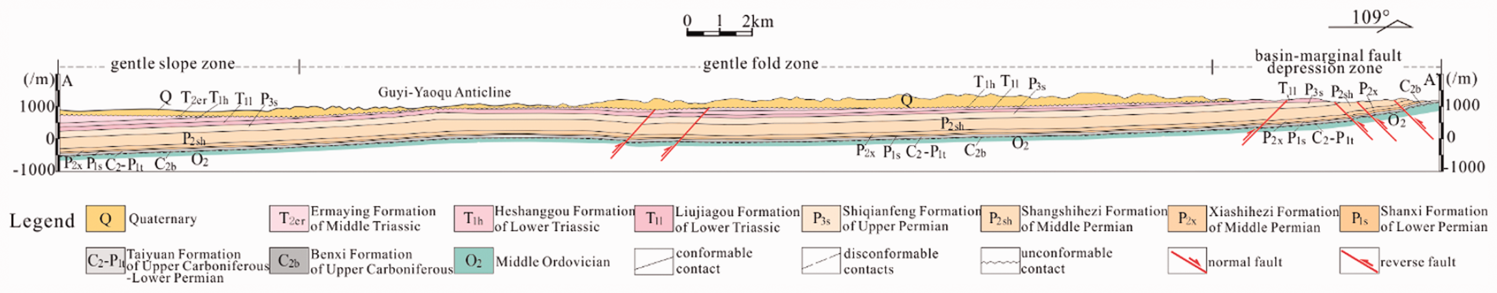
Structure profile of AA′ in the Daning-Jixian region (the location is shown in Figure 1).
As mentioned above, the structural deformation intensity decreases from the east to the west, suggesting that tectonic stress decreases from the east to the west and generates the distinct E-W zoning characteristics for the folds and faults in the Daning-Jixian block.
Characteristics of tectonic deformation
Field observations indicate that the structures in the east margins of the Ordos Basin are dominated by reverse faults extending NE–NNE. However, faults observed within the basin are relatively weak, and wide and gentle folds and bends are relatively well-developed, indicating that deformation intensity decreases from the basin margins to the interiors.
The fault depression zone in the basin margin
The Caigedagou reverse fault, a distinct reverse fault developed in the thin limestone seams of Majiagou Formation of the Middle Ordovician (Figure 3), was observed in the southeastern margins of the study area (OP10 in Figure 1). The fault extends in the NNE (30°) direction and dips NWW with dip angle about 43°. The fault plane is smooth and straight. The fault zone is narrow, and the layers in the hanging wall become bent during the thrusting process, leading to the traction structures simultaneously. The strata inclinations near the fault zone are high (larger than 50°) and decrease with the increasing distance to the fault plane, bringing about the traction anticline. The observed Caigedagou reverse fault reflects a strong tectonic compressive stress in the NW–SE direction.
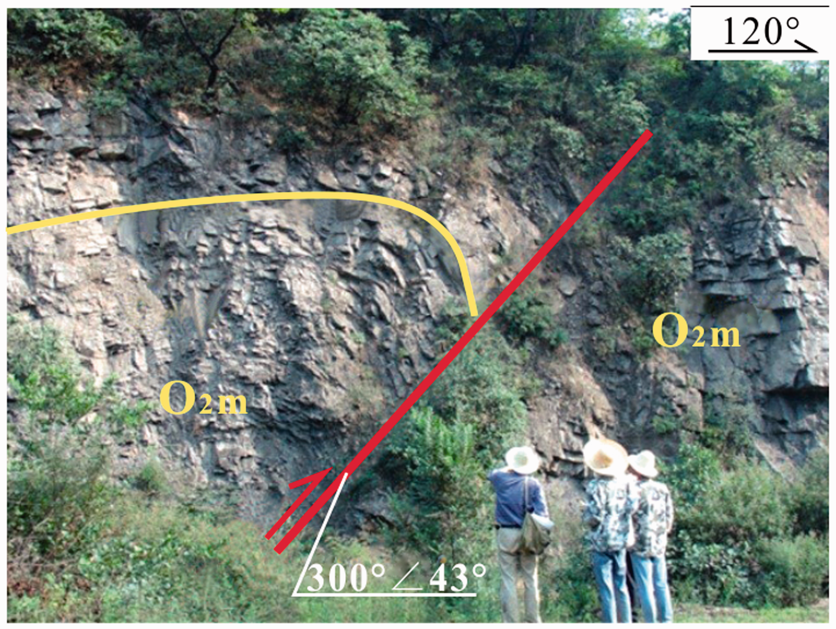
Observation point 10: the Caigedagou reverse fault and traction structures in the hanging wall.
The OP9 is about 10 km from the OP10 to the southwest, which shows a reverse fault developed in the deep gray thick limestone of the Taiyuan formation with an occurrence of 120°∠60° (Figure 4). The fault line is wavy bending and rocks in the fault zone are extremely broken. The structural breccia has a certain directionality. About 60 m to the east of this reverse fault, there is another reverse fault developed in the same formation with an occurrence of 110°∠36°. The layers in the hanging and foot wall are gray muddy siltstones and mixed mudstones, respectively. The fault plane is smooth and straight, and extruded schistosities are developed in the fault zone.
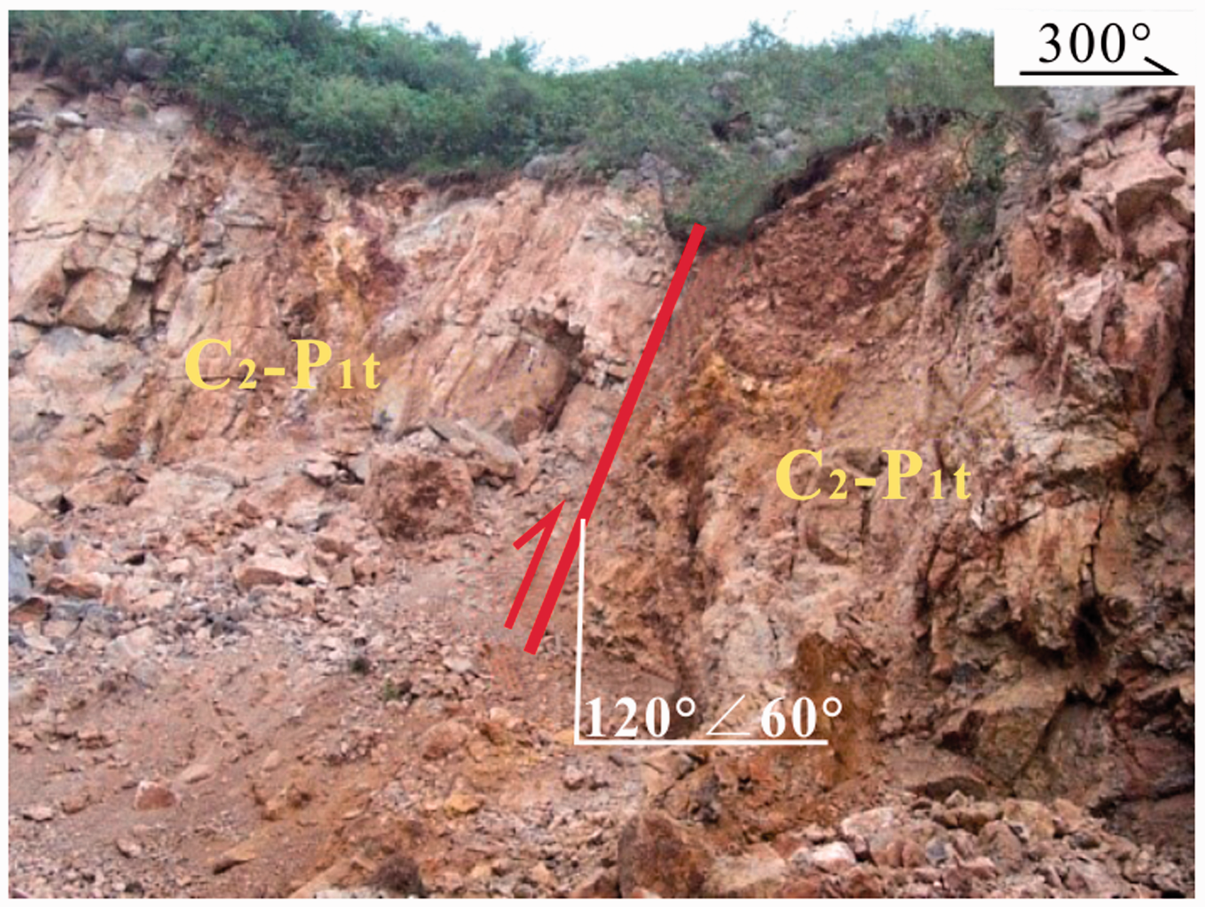
Observation point 9: A reverse fault.
The structures in this area indicate that they are dominated by reverse faults extending in the NE–NNE direction and relatively weak folds. The development of these structures embodies the deformation characteristics of the fault depression zone in the basin margin.
2. The gentle fold zone in the basin slopes
The structures in this area are characterized by the broad-gentle folds and bends extending in the NNE direction, e.g., the typical Guyi-Yaoqu fold zone.
Folds
The Yaojie broad anticline is located in the hillsides of western Yaojie (OP1 in Figure 1) and lies in the south of the Guyi-Yaoqu fold. The stratum in this fold is composed of the Middle Triassic Ermaying Formation (T2er), and the lithology is characterized by the middle-thick sandstones interbedding thin sandstones. The occurrence of its NW limb is 323°∠23° and the SE limb is 155°∠14°, suggesting an asymmetric anticline. The stratum occurrence in the hinge zone is 254°∠4°, indicating the anticline tilts slightly to the southwest (Figure 5).
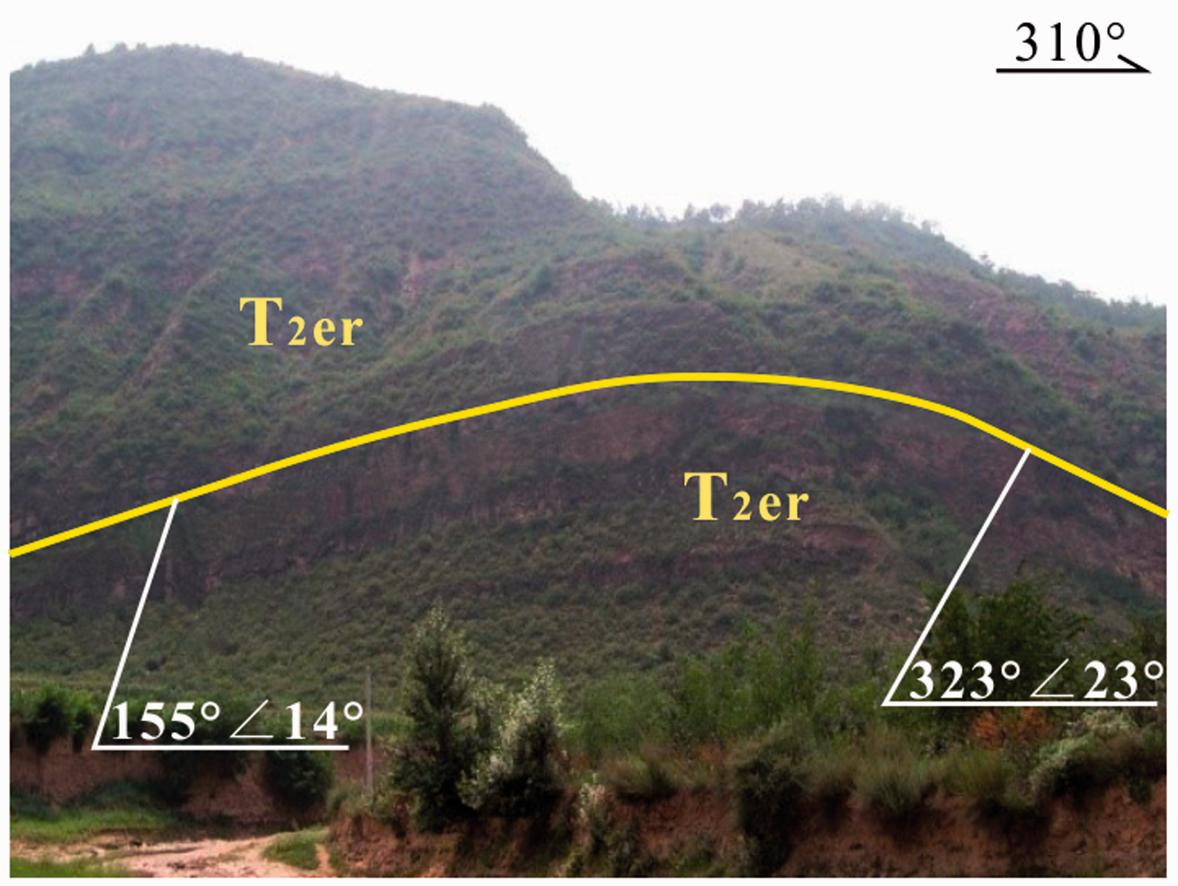
Observation point 1: A broad fold.
The southern Chejiapo broad anticline. This observation point is located in the north part of the Guyi-Yaoqu fold zone (OP4 in Figure 1), which is composed of the purple muddy sandstone and thin sandstone in the Ermaying Formation. The occurrences of the west- and east limb are 301°∠7° and 102°∠28°, respectively, suggesting an asymmetric anticline. There exists a longitudinal normal fault in the anticline hinge zone. The normal fault has a trend of 10° with a serrated fault plane, and the fault zone is about 20 cm in width (Figure 6). The generation of this fault is distinctly related to the tensile stress perpendicular to the axial direction in the anticline hinge zone.
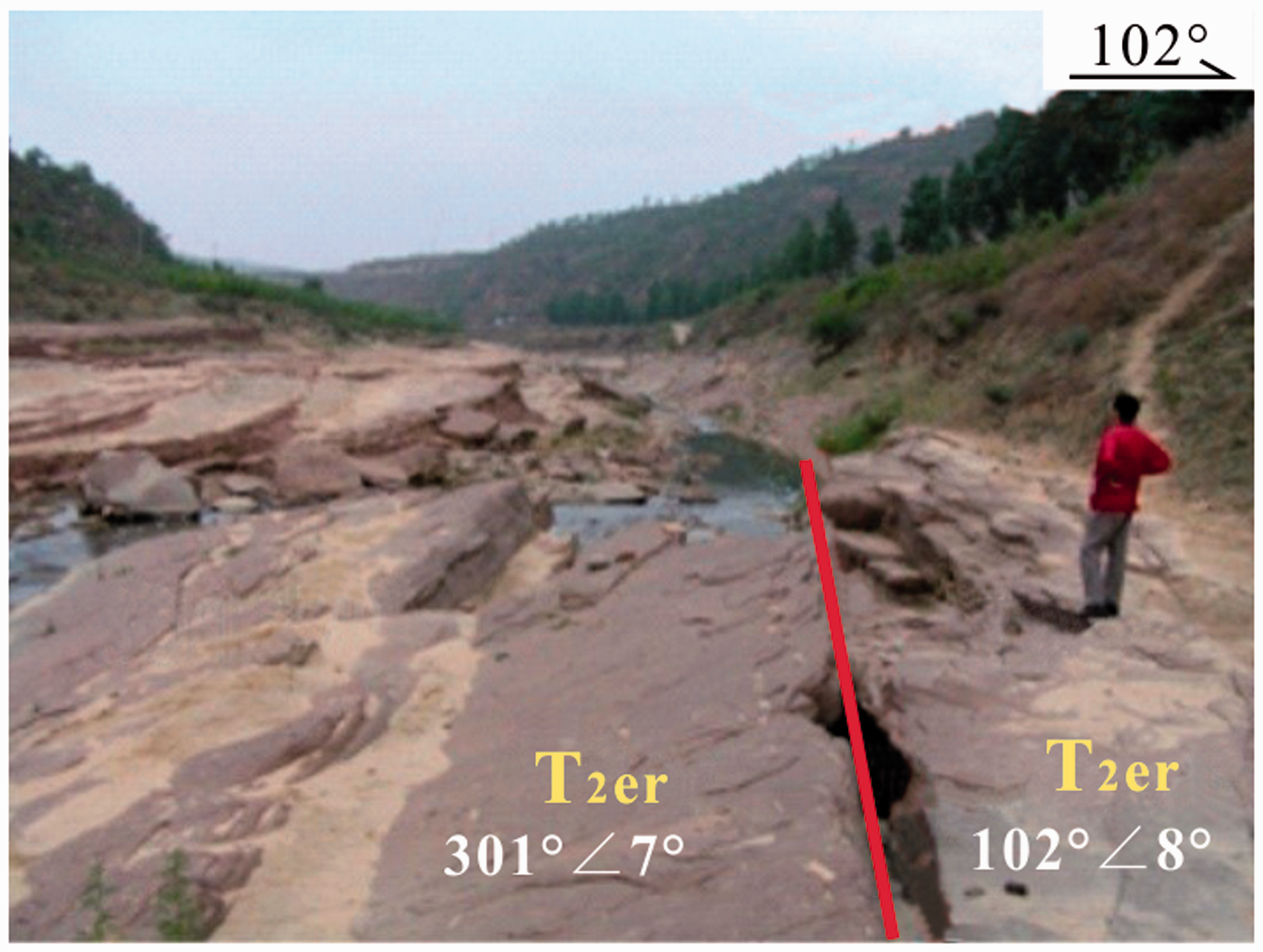
Observation ponit 4: the Chejiapo broad anticline and the longitudinal normal fault.
The above mentioned folds embody the typical characteristics of the Guyi-Yaoqu fold zone, which is dominated by the broad-gentle and asymmetric folds and the concomitant longitudinal normal faults. These structural characteristics have significant influences on the CBM preservation and coal reservoir permeability.
b. Faults
This tectonic zone is not only characterized by folds, but some small longitudinal reverse faults partially developed, such as the small-scale reverse faults distributed in the Guyi region (OP11 in Figure 1). The Guyi reverse fault develops in the purple shaly sandstone and thin grayish yellow sandstone of the T2er with an occurence of 185°∠51°, and the fault displacement is 1.2 m. The fault plane is tight and smooth with a slow-wave-like geometry shape in its inclination direction (Figure 7), which indicates the fault is a reserve fault.
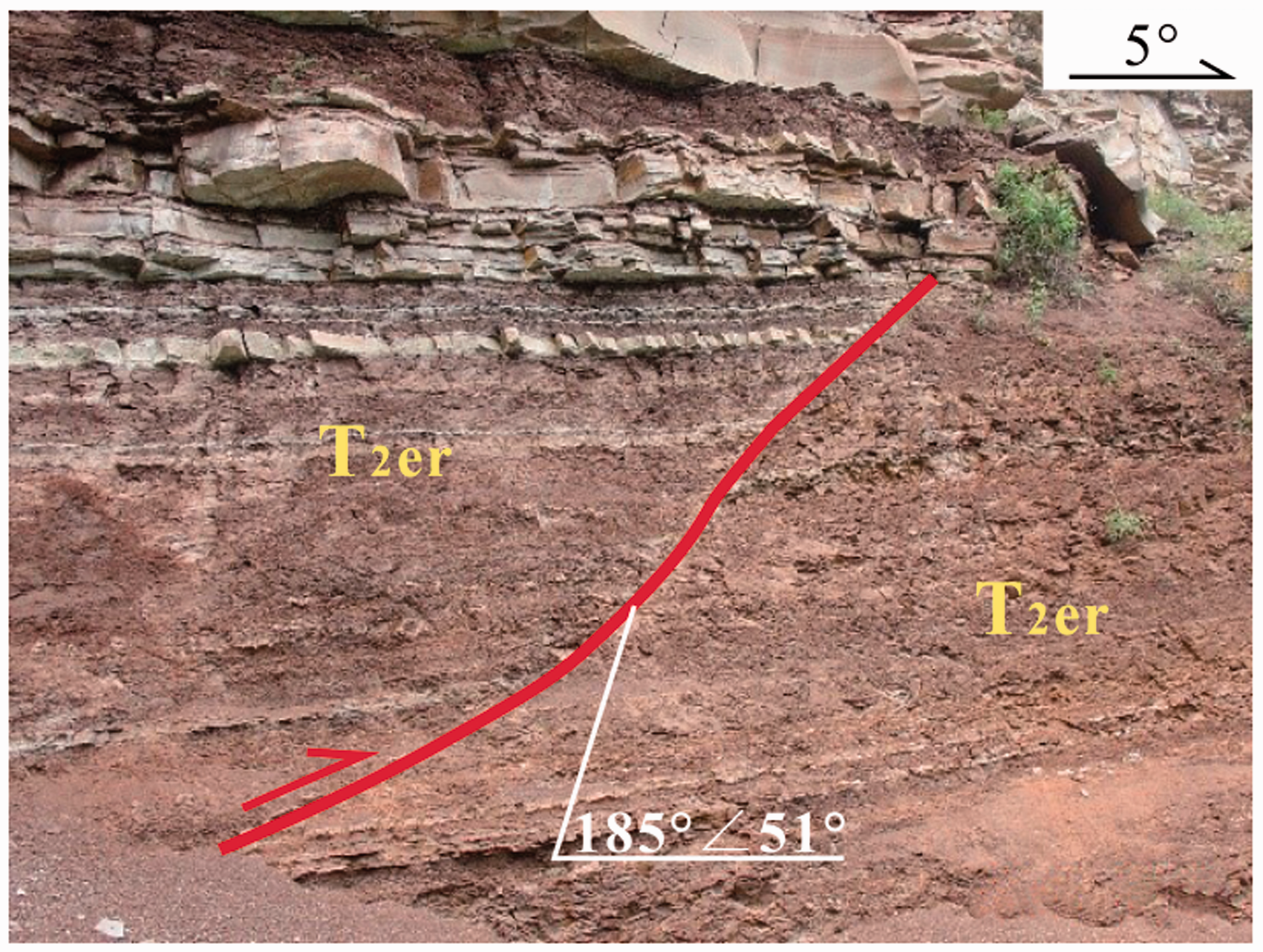
Observation ponit 11: the Guyi small reverse fault.
By field observation, the main structures developed in this area are folds and reverse faults extending in the NE–NNE direction. However, there are some differences in different zones. Generally, the degree of structural deformation decreases from the east basin margin to the inner study area, resulting in rather weak deformation intensity in the western gentle slope zone. Furthermore, NW-trending folds also develop partially in the study area. For example, the Pangjiageda flexure is observed in the fine sandstone of the Ermaying Formation (OP8 in Figure 1), with the formation occurrence of 239°∠25° in the SW wing and 59°∠9° in the NE wing, and fold axis extending in NW direction (Figure 8). Both of these structures indicate that this area has undergone multi-stage tectonic stress processes.
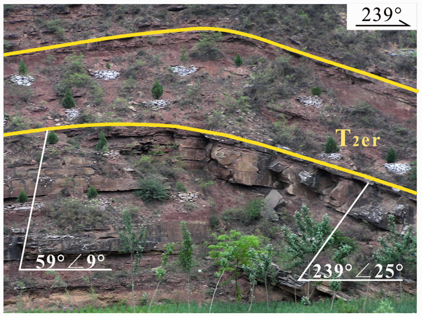
Observation point 8: the Pangjiageda flexure.
Tectonic evolution
The Carboniferous-Permian coal series layers in eastern Ordos Basin have successively suffered several tectonic deformations during the Indosinian, Yanshanian, and Himalayan period. The tectonic deformations during the Indosinian period are relatively weaker than those in the Yanshanian and Himalayan periods. The tectogenesis during the Middle Yanshan period is the critical event to form the tectonic frameworks in eastern Ordos Basin.
Since the Mesozoic, the evolution of the Ordos Basin has entered a period of intense intracontinental deformation and transformation (Liu et al., 2006), which results from the remote effects generated from dynamics effects of different plates and the tectonic mechanism transformations in the deep. The Ordos Basin has experienced tectonic transformations of multiple stage and various types during different periods. The main structures in this study area are in the NNE direction, which reflects the NW–SE compressive stress. However, due to the lack of relevant sedimentary records, the specific period of this stress field is difficult to be determined. Based on the comparison between the formation period of the Shanxi fault-uplift and the regional tectonic evolutions of the Ordos Basin, the tectonic traces in the Shanxi fault-uplift area are formed between the Late Middle-Jurassic Period and the Late Jurassic Period, corresponding to the main phase of the Yanshan movement in East China (Dong et al., 2000; Zhao et al., 2004). The oblique dive of the ancient Pacific Plate (Izanagi Plate) and the Eurasia Plate during the Middle to Late Jurassic resulted in the intense tectonic deformations and lifts in the regions east to the Ordos Basin (Maruyama et al., 1989; Van der Voo et al., 1999). The compressive component caused by this oblique collision acted on the Ordos block and formed a tectonic stress field with the main compressive direction of NW-SE. This tectonic event also resulted in the east-west differentiations in the unified North China basin simultaneously. The outlines of the modern Ordos Basin were established due to the development of eastern border zone. Thus, the Middle Yanshan tectonic movement is critical for the structural pattern of this area.
In the beginning of the Early Cretaceous, there was a significant turning point in the tectonic mechanism of East China and the tectonics are dominated by the stretch deformation of the lithospheric. The small-scale Yanshanian granite bodies developed along the eastern margin of the Ordos Basin are typically represented by the Zijingshan body in the eastern margin. The Zijingshan body (usually in pipe and sill shape) intruded into the gray green feldspar sandstone and clip red mudstone of the Ermaying Formation of the Middle Triassic. The age of this intrusive rock body is given through the Zircon method at (132.0 ± 2.1) Ma- (125.0 ± 6.7) Ma (the Early Cretaceous; Yang et al., 2006). It is generated through the shallow intrusion or volcanic eruption effects. The deep-sourced magma intrusion of the Early Cretaceous in eastern Ordos Basin is an indicator of the upwelling of Lvliang asthenosphere, large-scale uplifting in the eastern areas, and tilting of fault uplift zone, which is in line with the widely distributed tectonic events in the Early Cretaceous, namely, the tectonic transformations, thinning of the lithosphere, upwelling and underplating of the asthenosphere, and the corresponding tectonic thermal events in North China (Wu et al., 2003). This tectonic event has a significant impact on the preservation of CBM in the study area, resulting in CBM loss and gas content decrease in coal reservoirs.
In the Cenozoic, East China was mainly affected by two long-range tectonic stresses, namely, the collision between the Indian and Eurasian plates, and the subduction of the Pacific plate into the Eurasian plate (Deng et al., 1996). Under the control of regional tectonic evolution, the Himalayan stress field in the Ordos Basin also underwent a fundamental transformation from NW direction to NE direction. The preferred orientation of the maximum principal compressive stress axis and minimum principal compressive stress axis are 30°–210° (inclination: 1°–2°) and 121°–301° (the inclinations are nearly horizontal), respectively. Most of the middle principal compressive stress axes are almost upright or slightly inclined (Zhang et al., 2000). This stress transformation is caused by, on one hand, the NW-subduction of the Pacific plate into the Asia plate, which causes the NW–SE tensions of lithosphere blocks in East China and, on the other hand, the remote effects of the northward protruding of the Indian Plate after the collisions with the Asian Mainland in the Eocene.
The tectonic compression in the NE–SW direction during the Himalayan period caused a significant transformation on the Yanshanian tectonics. The properties of NNE–NE directional faults transform from initial compressive reverse faults into tensile normal faults, leading to the partial loss of CBM and the improvement of coal reservoir permeability to some extent. Simultaneously, the corresponding structures were also formed in the study area, e.g., the development of local NW-trending fold structures.
Influences of tectonics on CBM exploration and development
The relatively weak structural deformations in the study area have an effect on coal reservoirs, which improves the permeability of coal reservoirs to a certain extent and furtherly forms a favorable area for CBM exploration and development. However, the differential developments of structures also have a significant influence on the exploration and development potential in different blocks. The main coal seams for CBM development in this area are the No. 5 seam of the Shanxi Formation and the No. 8 coal seam of the Taiyuan Formation. Under the control of structures, some CBM features of the two coal seams have similarities; thus, the following discussion will take the No. 5 coal seam as an example.
Tectonic control on gas content
Gas content of coal reservoir is one of the main parameters for reservoir evaluation. Generally, it increases with the increasing burial depth of coal seam, so does this region. However, unique features still exist due to the development of structures.
Gas content data obtained from coal geological exploration and CBM wells indicate that gas content in the No. 5 coal is 10–20 m3/t (17.8 m3/t on average). Gas content contours extend in the NE–NNE direction, which is consistent with the direction of main structures in this area (Figure 9). Areas with gas content less than 10 m3/t are mainly distributed in the basin marginal fault belt in the eastern and southeastern part of the study area, where the depth of coal seam is shallow (generally less than 700 m) and the NE–NNE-trending fault structures develop intensely. Under the superposition and transformation of the Himalayan tectonics, the nature of these NE–NNE-trending faults transforms from compressive to tensile, which furtherly results in the CBM loss, and thus forms a low gas content band of CBM. From the fault depression zone in the basin margin to the gentle fold zone in the middle basin slopes, tectonic deformations become gradually weaker and burial depth of coal seam gradually increases (700–1000 m). The gas content also increases and the high-value areas are distributed in the Yaoqu-Wucheng region (with the maximum gas content exceeding 20 m3/t). Folds play important roles in controlling the formation of this high-value CBM zone. For example, the longitudinal normal faults may be developed in the anticline hinge zone. However, the No. 5 coal seam is below the neutral planes of the folds and is subjected to compressive stress, which is also beneficial for the preservation of CBM resources.
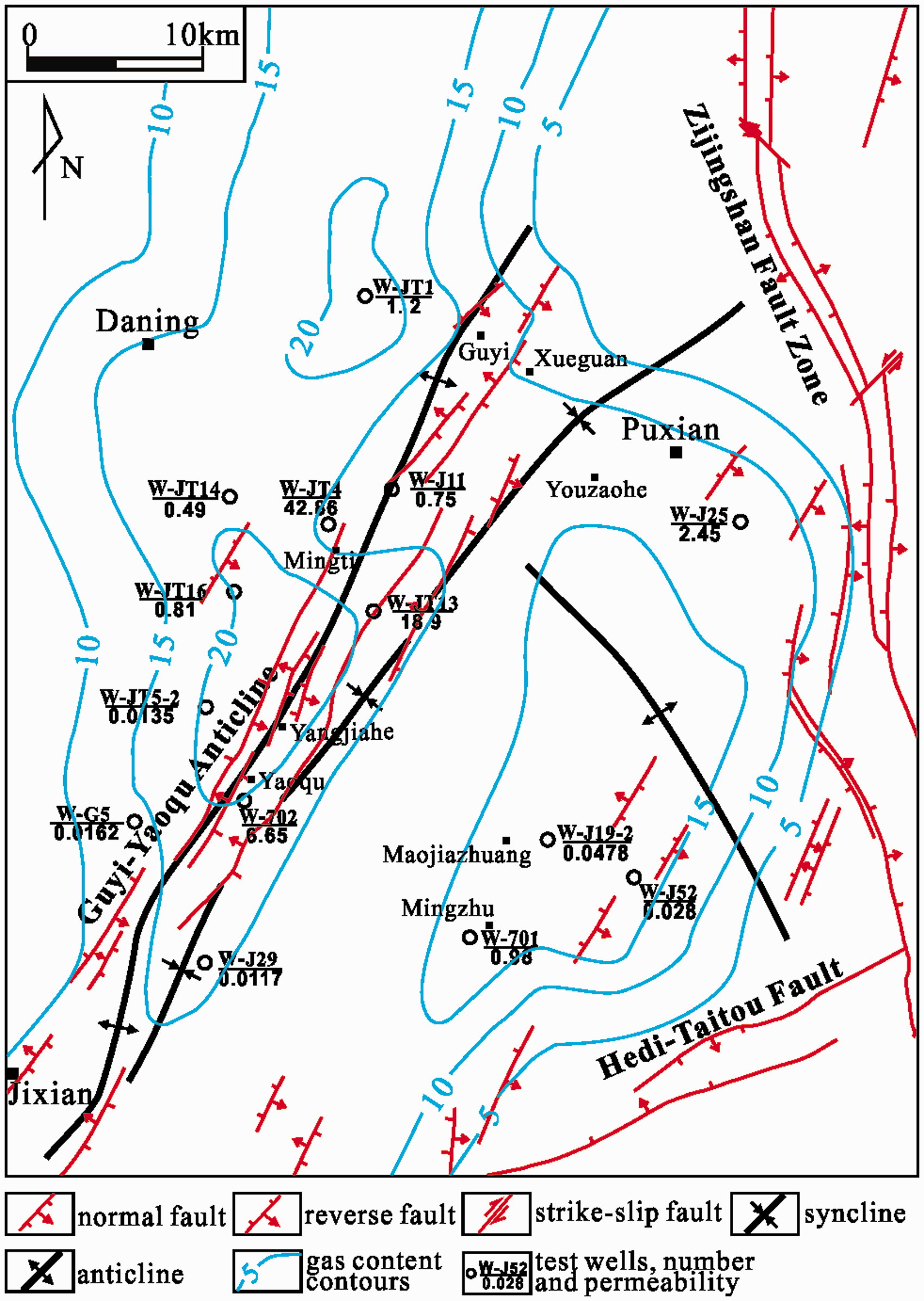
Coal seam CBM content contour of the No. 5 coal seam in the Daning-Jixian region.
Tectonic control on coal reservoir permeability
The well tests indicate that the permeability of the No. 5 coal seam varies greatly with a magnitude difference of three orders. Most wells show low permeability except those with high permeability (up to more than 10 × 10−3 µm2 in W-JT4 and W-JT13). The permeability ranging from 0.01 to 0.1 × 10⁻³ µm2 accounts for 31.25%, 0.1 to 1 × 10⁻³ µm2 for 37.5%, 1 to 10 × 10−3 µm2 for 18.75%, and greater than 10 × 10−3 µm2 for 12.5%.
Wells with high permeability in the No. 5 coal seam (W-JT4, W-JT13, and W-702) are located in the Mingti-Yangjiahe region, which structurally lies in the middle part of Guyi-Yaoqu anticline. This area experienced a relatively strong structural deformation within the gentle fold zone in the middle basin slopes, and joints are also well developed accompanying with folds and faults. In general, macro-fractures are important channels for CBM migration, while micro-fractures are the bridges or intermediate channels for communicating pores with macro-fissures. Macro-fractures and micro-fractures contribute the most to coal reservoir permeability (Fu et al., 2011). The structural deformation intensity in the study area changes in the pattern of strong–weak–strong–weak from the east to the west, and fracture density displays the variation of high–low–high–low accordingly (Wang et al., 2016). High permeability areas (W-JT4, W-JT13, and W-702) are located in the second strong deformation belt, where there are high fracture density and high density (more than 12%) of advantage fracture groups (with strike of 55°). These advantage fracture groups are in the same direction with the present-day maximum principal stress (Wang et al., 2018), which facilitates the opening of fractures and effectively increases the permeability of coal reservoirs. High permeability in W-J25 and W-701 of the eastern margin are also closely related to the developments of faults and fractures (Figure 9).
Target area evaluation
The structural transformation in the Daning-Jixian region increases the heterogeneities of the distributions of burial depth and reservoir properties. Gas content, burial depth, and the permeability of coal reservoirs are key geological factors affecting CBM exploration and development. In the study area, high gas content larger than 15 m3/t could be found in most of the western parts (to the west of the Guyi-Yaoqu fold belt); however, these areas are buried deeply (more than 1000 m). In the middle and southern part of the Guyi-Yaoqu fold belt, coal permeability is the highest, gas content is also relatively high; however, large burial depths of coal seam and complicated structures characterize these areas. In the eastern marginal regions, coal permeability is high, but the structures are complicated and gas content is also relatively low. Therefore, we argue that the Guyi and Mingzhu areas are favorable target areas for CBM exploration and development.
The Guyi target area
The Guyi target area is located in the northern part of Guyi-Yaoqu fold belt (Figure 10). In this area, NE-trending folds are well developed. Especially, a broad and gentle syncline in the middle of Guyi area provides favorable spaces for the accumulation of CBM. The burial depth of the No. 5 coal is ranging 600–1000 m in this area. The gas content in this broad-gentle syncline gas zone is relatively high (8–20 m3/t). Faults are not well developed; however, there is rather high fracture density in this target area. In addition, the good configuration relationship between NE-trending favorable fractures and the present-day in-situ stress increases coal reservoir permeability to a certain degree. The permeability by well testing in this area is generally high and can reach 1.2 × 10⁻³ µm2 in W-JT1.
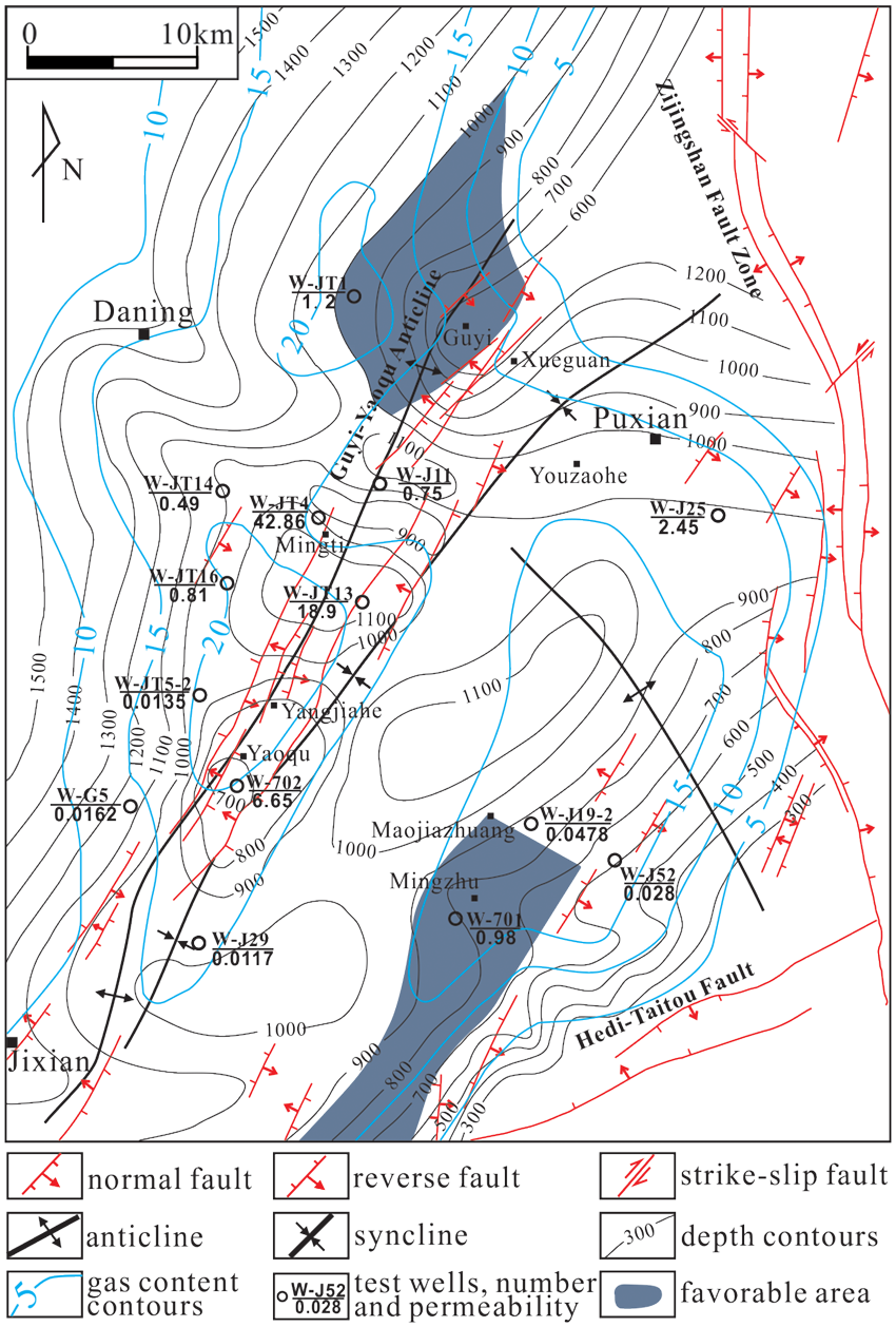
Distribution of well test permeability in the No. 5 coal seam, Daning-Jixian region.
The Mingzhu target area
The Mingzhu target area is a nearly rectangular area, which is a transition area between the fault depression zone and the gentle fold zone (Figure 10). The burial depth of the No. 5 coal is ranging 700–900 m in this area. The gas content in most of the areas is up to 15 m3/t. Structures in this target area are relatively simple and the broad-gentle folds are developed under the overall NW-trending tectonic background. However, due to the small distances to the fault depression zone in the eastern margin, fractures are well developed. These fractures are dominated by two groups with the NE and NW trends, respectively. In particular, the development of NE-trending fractures facilitates the increase of coal reservoir permeability. The permeability in W-701 is up to 0.98 × 10⁻³ µm2 and is favorable for CBM development.
Conclusions
The Daning-Jixian region is located in the eastern margin of the Ordos Basin. The main structures in this region extend in the NE–NNE direction with distinct zoning in the E-W direction, which can be divided into the fault depression zone in the basin margin, the gentle fold zone in the basin slopes and the gentle slope zone from the east to the west. Structural deformation in the fault depression zone is the strongest, where a series of compressive faults, bends, and concomitant structures are developed. Structures of the gentle fold zone in the basin slopes are dominated by broad-gentle folds and small-scale faults in certain areas. The strata in the west gentle slope zone dip west with small dip angles. Although there are small amounts of wavy fluctuations, the amplitudes are rather slight; thus, the west gentle slope zone generally manifests as a monocline structure with a gentle dip. The tectogenesis during the Middle Yanshan period is the critical tectonic event for forming these structure frameworks. The development and evolution of faults and folds in the study area have a crucial controlling effect on the CBM occurrence, gas content, and permeability. Since the main structure in the Daning-Jixian region is a monocline with a gentle inclination to the west, gas content in the No. 5 coal gradually increases from the east to the west. The CBM gas-bearing contours are in the NE–NNE direction, which is consistent with the directions of main structures in this region. The eastern margin zone is affected by strong structural deformation and constitutes a low gas content zone. From the fault depression zone in the basin margin to the gentle fold zone in the middle basin slopes, structural deformations become gradually weaker and burial depths of coal seam gradually increase (700–1000 m). Gas content also increases and the areas with high gas content are distributed in the Yaoqu-Wucheng region. Wells with high permeability in the No. 5 coal seam (e.g., W-JT4, W-JT13 and W-702) are distributed in the Mingti-Yangjiahe region, middle of the Guyi-Yaoqu anticline. This area has a relatively strong structural deformation within the gentle fold zone in the middle basin slopes. Fractures are well developed accompanying with folds and faults in this area. These favorable fracture groups (with strike of 55°) are in the same direction with the present-day maximum principal stress orientation (NE), which facilitates the opening of fractures and effectively increases the permeability of coal reservoirs. High permeability in W-J25 and W-701 in the east margin are also closely related to the developments of faults and fractures. The Guyi area and Mingzhu area are optimally selected as the favorable target areas for CBM development through a comprehensive analysis of burial depth, CBM content, and the permeability.
Footnotes
Declaration of conflicting interests
The author(s) declared no potential conflicts of interest with respect to the research, authorship, and/or publication of this article.
Funding
The author(s) disclosed receipt of the following financial support for the research, authorship, and/or publication of this article: the National Natural Science Foundation of China (Grant No. 41430317) and National Science and Technology Major Project (Grant No. 2011ZX05034).