
Abstract
The geochemical characteristics of geothermically heated water can reveal deep geothermal processes, leading to a better understanding of geothermal system genesis and providing guidance for improved development and utilization of such resources. Hydrochemical and hydrogen oxygen isotope analysis of two geothermal field (district) hot springs based on regional geothermal conditions revealed that the thermal water in the Litang region is primarily of the HCO3Na type. The positive correlations found between F−, Li2+, As+, and Cl− indicated a common origin, and the relatively high Na+ and metaboric acid concentrations suggested a relatively long groundwater recharge time and a slow flow rate. The values of δD and δ18O were well distributed along the local meteoric line, indicating a groundwater recharge essentially driven by precipitation. The thermal reservoir temperature (152°C–195°C) and thermal cycle depth (3156–4070 m) were calculated, and the cold water mixing ratio (60%–68%) was obtained using the silica-enthalpy model. Finally, hydrogeochemical pathway simulation was used to analyze the evolution of geothermal water in the region. The results were further supported by the high metasilicate content in the region. Of the geothermal fields in the region, it was found that the Kahui is primarily affected by albite, calcite precipitation, and silicate, while the Gezha field is primarily affected by calcite dissolution, dolomite precipitation, and silicate.
Introduction
Geothermal reservoirs, an important source of clean and renewable energy, are extremely significant to environmental and social development. Studies of the hydrogeochemical properties of geothermal fluids provide information not only on the hydrochemical composition and recharging sources of groundwater but can also reveal the thermal cycle mechanism, which can guide the evaluation, exploration, and use of geothermal resources.
Early hydrogeochemical research focused primarily on regional hydrogeology and the exploration and exploitation of groundwater (Shen, 1985). Since the 1960s, attention has shifted to the geochemical activity of groundwater within the Earth’s crust (Ren and Shen, 1993). Stumm and Morgan (1981) published systematic methods for the quantitative analysis of various chemical processes in natural water environments. Ye et al. (2002) comprehensively reviewed the geochemistry of groundwater and its applications in different fields. Subsequently, scientists have studied the hydrogeochemistry of groundwater in different regions worldwide. Dworkin (2003) and Isabella and Jacinta (2018) analyzed the groundwater hydrogeochemistries of the Lake Waco drainage basin in Texas, United States and São Paulo State, Brazil, respectively. Ali and Hossein (2018) and Nematollahi et al. (2018) conducted hydrogeochemical analysis of the subsurface geothermal water and assessed the water quality of northern Isfahan and Gilan Provinces, Iran. In China, Zhao et al. (2001) studied the hydrogeochemistry of the geothermal fluids in Tibet’s Yangbajain Geothermal Field from 1998 to 2002, laying a foundation for geothermal fluid research in Tibet. Liu et al. (2007) investigated the hydrogeochemistry and genesis of granites in Weixi, Yunnan. Pu et al. (2010) researched the hydrogeochemical properties of underground rivers in the karst area of Chongqing. Li et al. (2013) characterized the hydrogeochemistry and investigated the origin of waters in the Yangshan mining field.
The Qinghai–Tibet Plateau west of Sichuan connects with the Sichuan Basin to the southwest. The region can be broadly divided into three parts: the Luhuo–Kangding, Litang, and Batang–Xiangcheng areas, which are located on the Xianshuihe, Ganzi–Litang, and Jinsha River fault zones, respectively. Xu et al. (2011) characterized the geothermal resources of the Sichuan Basin by calculating terrestrial heat flows based on logged borehole temperatures. Their results suggested a thermal conductivity stratigraphic column for the sedimentary rocks in the region and found lithology to be the dominant controlling factor. Luo et al. (2016) studied the geothermal resources in Sichuan and classified them as either rifted mountain or sedimentary basin geothermal systems. In particular, Western Sichuan is an example of the former and primarily contains zoned (tectonic fissure type) thermal reservoirs of metamorphic rocks and mixed stratified (sedimentary basin type)/zoned thermal reservoirs (Ni et al., 2016) dictated by tectonic faults. Zhang et al. (2017) analyzed the geothermal fluids of Western Sichuan and classified the hydrothermal systems in the area into Batang and Kangding types, with atmospheric precipitation and surface water as their primary hydrothermal sources. These waters infiltrate underground through fault cracks and undergo heating cycles associated with crustal heat sources to form subsurface hydrothermal waters. These studies have played an irreplaceable role in the evaluation and exploitation of geothermal resources. However, to date, there has been no systematic and comprehensive study of deep underground geothermal processes or geothermal water genesis mechanisms in the Litang area of Western Sichuan.
To address this gap, this study built upon the findings of previous studies to systematically assess the hydrogeochemical characteristics of underground hot springs in the Kahui and Gezha geothermal fields of the Litang region, with the goal of gaining a better understanding of the geochemistry of the subterranean hydrothermal systems in the area. Based on the water–rock interaction equilibria, the thermal reservoir temperature, cold water mixing proportion, thermal cycle depth, etc. were calculated for Kahui to determine the genesis mechanism of geothermal fluids. Finally, deep geochemical processes and water–rock interactions were ascertained through a simulation of the hydrogeochemical paths of geothermal water in Litang.
Study area
Western Sichuan, frequently referred to as the Garzê Tibetan Autonomous Prefecture, is in the tectonic-erosion, hilly plateau topography area located at the margin of the rifts within the Qinghai–Tibet Plateau in the collision zone between the Indian and Eurasian Plates (Figure 1(a)). The surface of the Litang region of Western Sichuan features gently rolling hills with a paleo-planation surface that remains intact. The surface height varies mostly within a 20–100 m range up to a maximum of 300 m. The terrain is open and flat, with a valley bottom width ranging from thousands of meters to tens of kilometers. The Wuliang River (also known as the Litang, Lequ, or Muli River) is a secondary tributary of Jinsha River that flows through the region. It originates from the Xiasai Snow Mountain Pass (5838 m above sea level) in the Shaluli Mountains of Litang County. The river runs for 516 km through a drainage region of 19,114 km2 with a 3050 m drop in elevation. The discharge rate at its estuary is about 268 m3/s, and its runoff volume is 5.86 billion m3. It is a narrow alpine valley river with many fast-flowing rapids. The flow of the river, which is supplied by precipitation and a small amount of snowmelt, is abundant and stable.
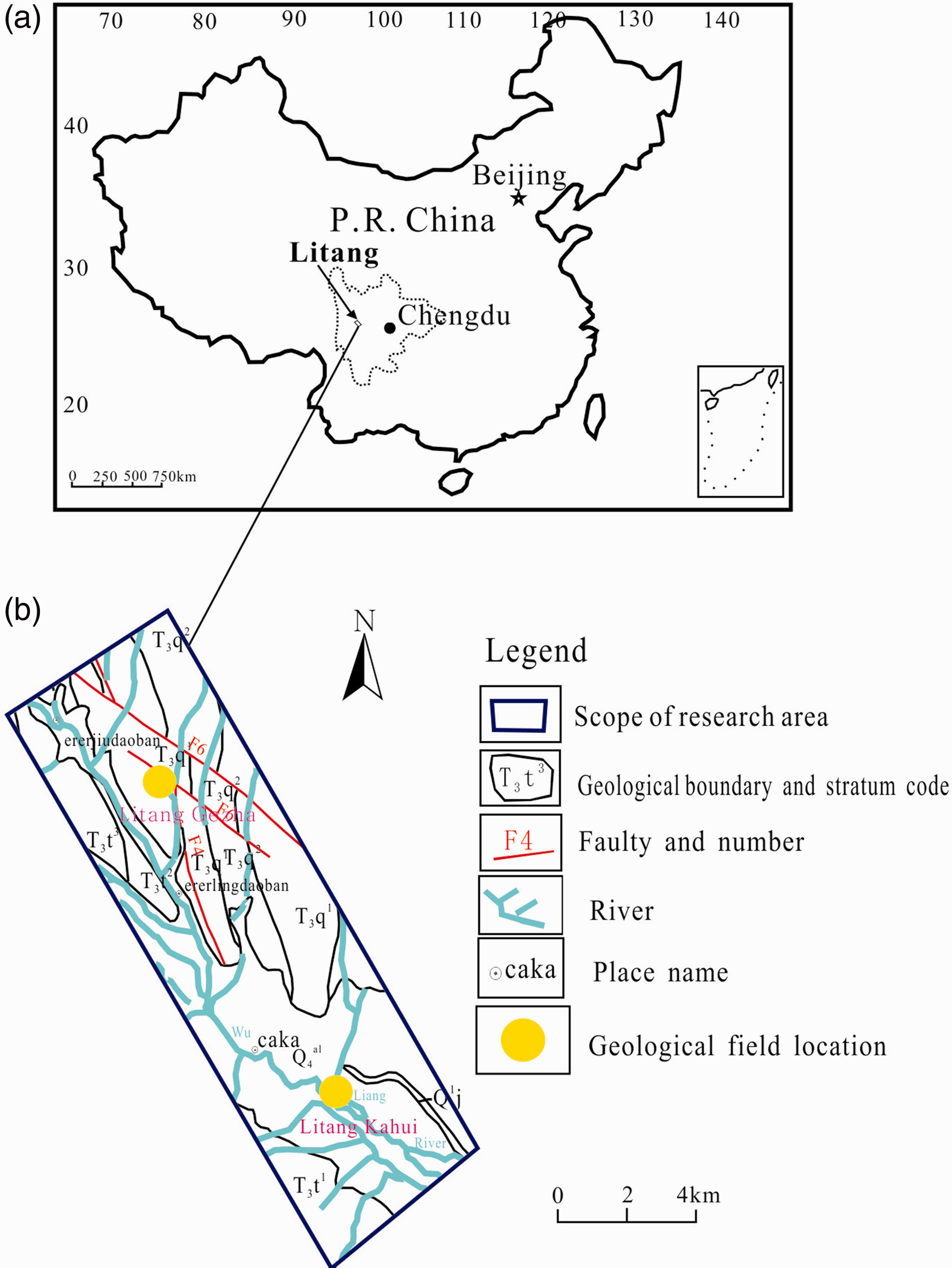
(a) Location of Litang in China and (b) geological map of the region.
The primary fault structures in the Litang region include the Dasen Longwa, Mogang Longwa–Gulu, Yahuo–Zhuoxi, and Jinchanggou faults (Figure 1(b)), which are exposed on the right bank of the Wuliang River and to the east of the Dasen Longwa fault zone. The Dasen Longwa fault is located between the southern section of the Xiongjingsi-Anggi and Dagang Longwa-Gulu faults and extends in a north–south direction along the upper reaches of the Dasen Longwa fault zone. Rock fragmentation and structural lenses have developed along the fault zone. The flat surfaces of the lenses are inclined to the west, while basic dikes have developed along the fault zone. The Mogang Longwa–Gulu fault, one of the main faults in the Litang fault zone, extends roughly parallel to the Yahuo–Zhuoxi–Shijingsi–Anggai fault on both sides, forming the middle part of the Garze–Litang fault zone. Its fracture band extends from tens to hundreds of meters in width and features fault breccia, labyrinthite, fault gouge, and compressive structural lenses. Along the fault, dense cleavage and schistosity occur in the rocks, with the cleavage piercing the schistosity. The Yahuo–Zhuoxi fault, one of the main faults in Litang–Ganzi fault zone, has a nearly north–south strike and features a prominent slow wave bending. The fracture band of the fault is tens to more than one hundred meters wide and features many structural lenses. Sheet minerals such as breccia and mylonite are well-developed in different parts of the fault and have obvious directional arrangements. The direction of the fracture is consistent with the strike of the fault. The Jinchanggou fault is the main fault in the region, with a fault plane inclining toward the northeast at 70°–80°. The fracture has width of tens of meters with visible outcroppings of breccia and fault gouge.
The main outcrops of Litang region are Triassic in age, particularly Upper Triassic, followed by magmatic rocks and Cenozoic strata. Most of the geothermal water in this region is stored in the carbonate rocks of the Triassic strata in either the upper (water temperature > 150°C) or lower (water temperature > 200°C) thermal reservoirs (Zhao, 1988). The geothermal fluids of Litang comprise primarily thermal springs occurring in belt-shaped groups in the fault zone that produce high volumes of gas. With water temperatures of 42°C–87°C and many calc-sinter waterfalls below their mouths, these springs are typical examples of high-temperature geothermal anomalies. Lithologically, the region can be divided into three sections. The lower section (T3t1) is 500–1630 m thick and contains mainly gray–black calcareous sericite slate, silty slate with some metasandstone, and unstable gravel and bioclastic rocks at its base. The middle section (T3t2) is more than 500 m thick and composed of metamorphosed gray lithic feldspathic quartzarenite, black slate with rhyolite interlayers of different thickness, and limestone. The upper section (T3t3) is more than 1200 m thick and is primarily composed of gray–black slate with a small amount of metamorphosed litharenite, and lithic feldspathic quartzarenite.
Sample collection and characterization
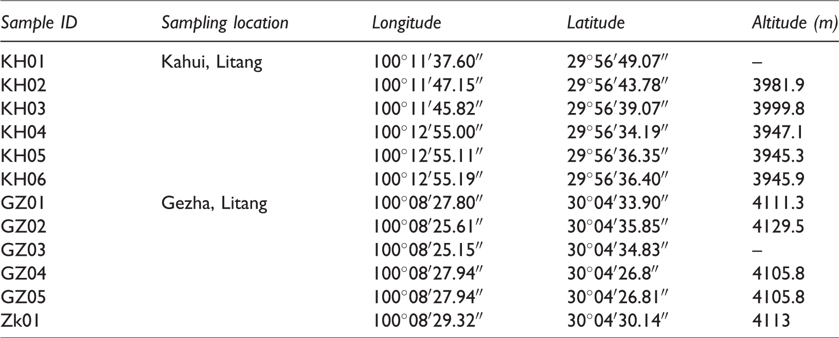
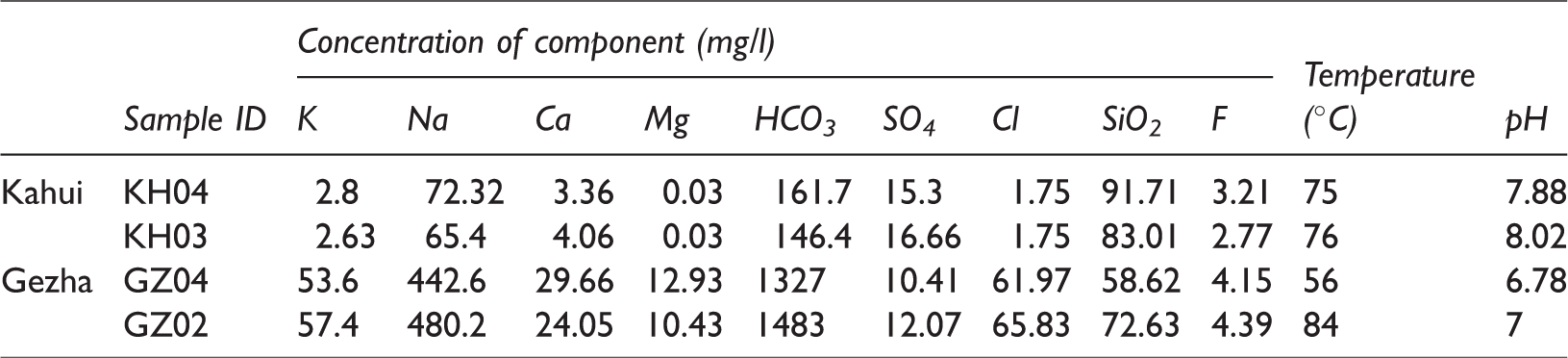
Twelve samples, comprising 10 sets of underground hydrothermal samples, 1 set of surface low-temperature water samples, and 1 geothermal well sample, were collected from Litang. Five of the hot spring samples and the set of low-temperature spring samples were collected in Kahui, while the remaining five sets of hot spring samples and the geothermal well sample were collected in Gezha. During sampling, water vapor separation was carried using the exhaust method. Table 1 lists the locations from which the samples were taken; note that sample Zk01 was taken at a depth of 402.6 m.
Locations of sampling points in the Litang region.
With the exception of Zk01, the samples of were sent to the Key Laboratory of Groundwater Sciences and Engineering (under the Ministry of Natural Resources, People’s Republic of China) of the Institute of Hydrogeology and Environmental Geology, Chinese Academy of Geological Sciences for a comprehensive analysis of water quality and a hydrogen and oxygen isotope analysis. The water quality was analyzed as detailed in the National Standardized Tests of Consumable Natural Mineral Water, People’s Republic of China (GB/T8538-2008) guidelines. The cation and anion concentrations were measured using inductively coupled plasma analysis and ion chromatography, respectively. The charge-balance error was restricted to less than 3%. Hydrogen and oxygen isotopic compositions were determined by wavelength-scanned cavity ring-down spectroscopy at 23°C and 50% humidity. The Zk01 gas components were sent to the laboratory of the Sichuan Institute of Geological Engineering Investigation and measured via GC122 gas chromatograph at a charge-balance error of less than 5%.
Results
Geochemical characteristics of the geothermal fluids
Analysis of hydrochemical characteristics
Within the study area, the pH of the geothermal water of the Litang region is 6.73–8.2 (average 7.53). More specifically, the pH in Kahui is weakly alkaline at 7.76–8.2, while that in Gezha is neutral at 7. The fault zones of Litang primarily comprise metamorphic rocks and granite. Leaching processes occurring during water–rock interaction induce the various types of feldspar in the rocks to react with geothermal water, leading to elevated concentrations of Na+ and HCO3− in the water.
As shown in Figure 2, the geothermal waters of Kahui and Gezha have very different ionic compositions and pH values. Kahui is located at the Rena fault, where the thermal reservoir is primarily argillaceous slates. By contrast, Gezha sits on the Yahuo–Zhuoxi and Jinchanggou faults in which slate, phyllite, and dolomite comprise the rocks of the thermal reservoir. Spring waters south of Wuliang River (Kahui) are alluvial or diluvial in origin and low in ionic content and mineralization, while those north of the river (Gezha) originate directly from the Triassic sandstones and slates, giving them high ionic content and degree of mineralization.
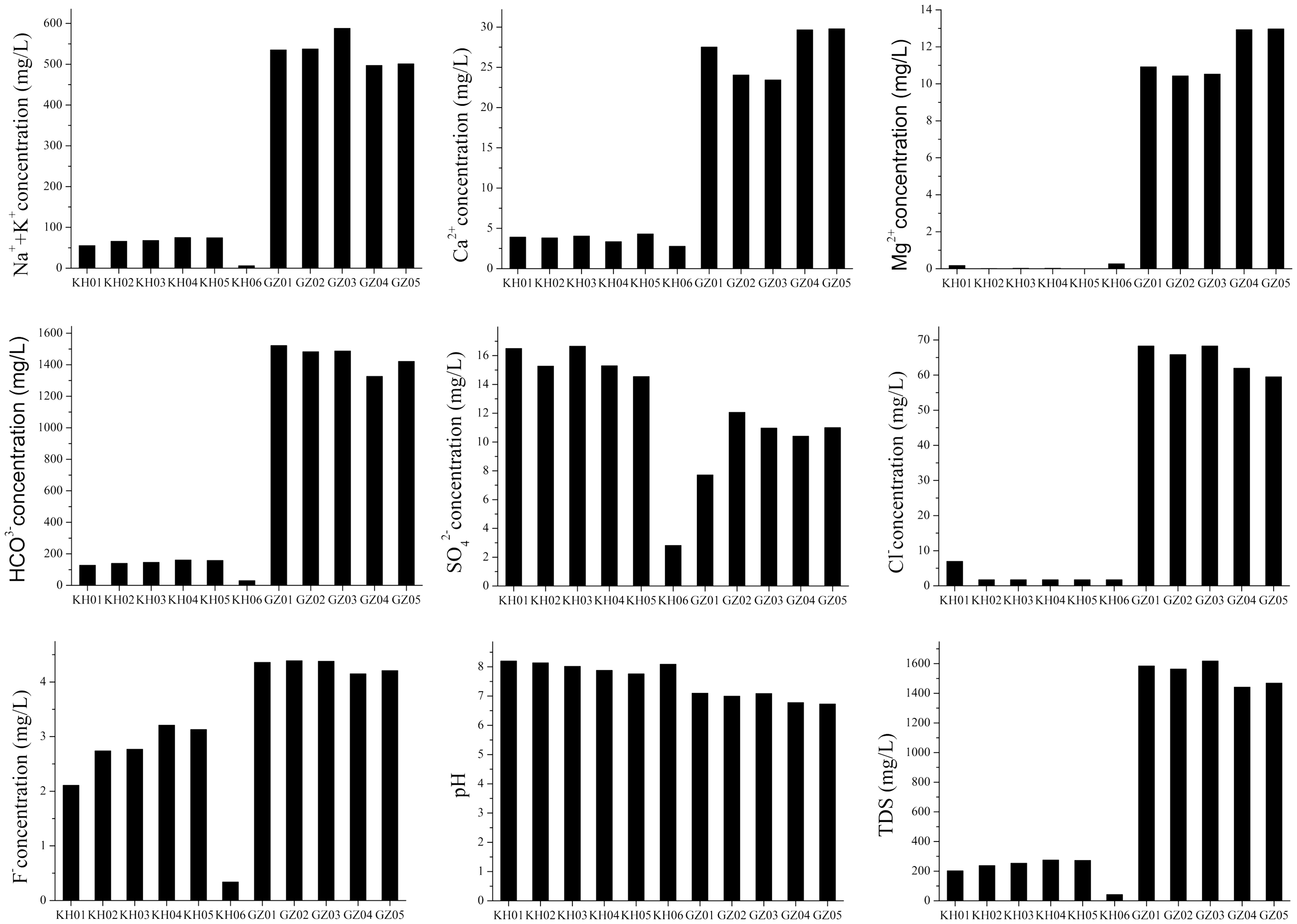
Concentrations of dominant ions and pH values of geothermal water samples from the Litang region. TDS: total dissolved solids.
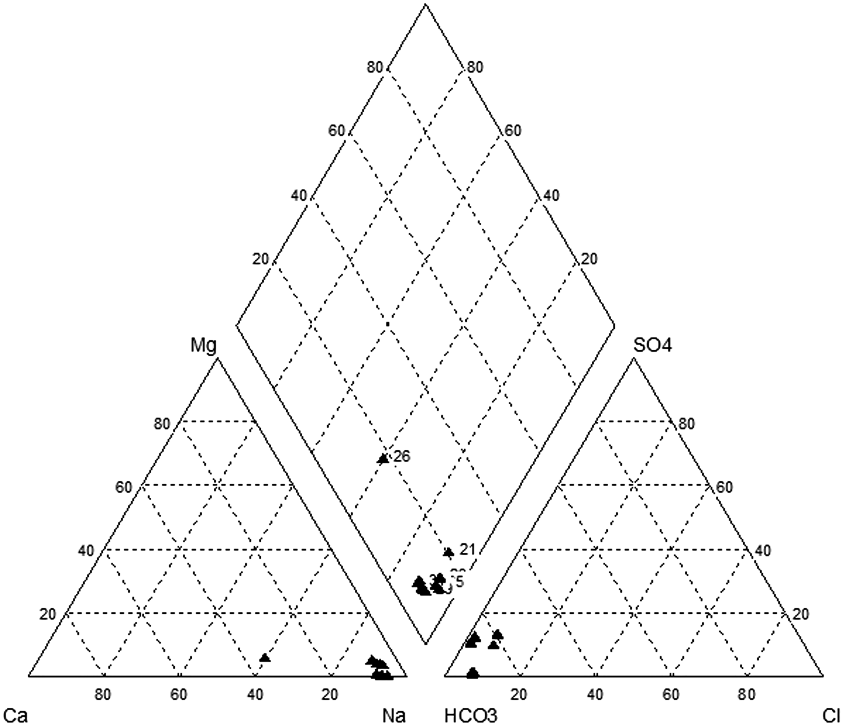
Piper trilinear chart for the groundwater hydrochemistry of the Litang region.
3. To further illustrate the hydrochemistry of the geothermal water, piper trilinear diagrams were drawn using the ionic compositions of water samples collected in the Litang region of Western Sichuan (Figure 3). As seen in the figure, the dominant cation of Kahui and Gezha is Na+, with some places richer in Ca2+, while geothermal fluid samples containing Mg2+ are relatively rare. HCO3 comprises a large proportion of the anions, followed by Cl− and SO42−. It can therefore be concluded that the groundwater of the Litang region is essentially of the HCO3Na type, with a few cases of HCO3Na·Ca type. As HCO3 tends to hydrolyze rather than ionize, its aqueous solution is often alkaline, with pH values similar to those discussed in the previous sections.
4. Similarities in the chemical compositions of geothermal water samples from neighboring areas are attributable to hydrological action and are also an indirect indication of groundwater runoff. Thus, an analysis of interrelated chemicals in groundwater hydrochemistry is crucial to understanding the groundwater cycle mechanism. Owing to its inertness toward other minerals and its resistance to be adsorption, chloride in water is relatively stable and can be used to trace ions with which it is closely correlated (Lang et al., 2016).
It is seen from Figure 4 that both Sr2+ and Li+ are positively correlated with Cl− in the Litang region. Chloride comes primarily from deep in the Earth (Zhao, Jin et al., 1998), which could therefore also be an origin of the Sr2+ and Li+ other than dissolution of relevant minerals. The concentrations of Na+ and Cl− are related to the time that the geothermal water spends as a subterrestrial runoff. Litang has very high Na+ concentrations, indicating long-term geothermal water runoff and a deep thermal cycle (Zhang et al., 2016). HBO2 is a very common chemical component in geothermal water, and both the dissolution of boron-containing minerals during water–rock reactions and the runoff conditions of geothermal fluids influence the formation, migration, and enrichment of boron, with higher geothermal fluid runoff intensities resulting in lower boron concentrations (Yuan, 2010). The elevated boron concentrations in Gezha relative to Kahui indicate that the intensity of groundwater runoff in Gezha is lower and the flow is slower. Similarly, the higher concentrations of total dissolved solids in Gezha indicate more water–rock reaction in this field. The concentration of metasilicic acid in geothermal water generally increases with temperature, with the high content of metasilicic acid commonly seen in Western Sichuan primarily caused by silicates being released from magmatic or metamorphic rocks via leaching and weathering and then migrating slowly through the long underground runoff, which facilitates the dissolution of more metasilicic acid into the geothermal water.
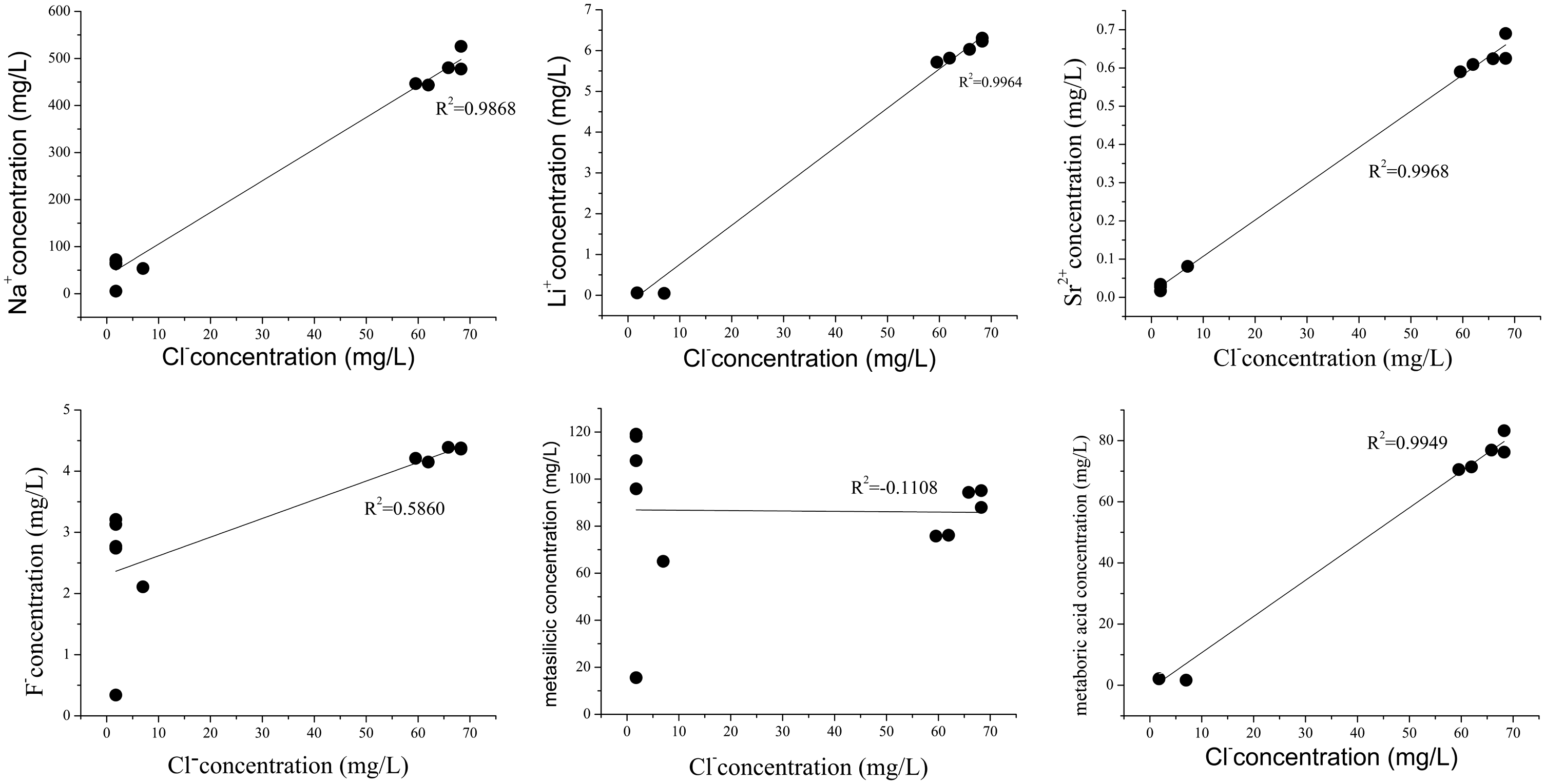
Relationships between chloride and trace element concentrations.
Analysis of isotopic characteristics
Characteristics of stable hydrogen and oxygen isotopes
The characteristics of hydrogen and oxygen isotopes in groundwater can help explain the genesis, recharging source, and relationship of the groundwater to meteoric and surface waters as well its circulation path. As the vapor pressures of D and 18O are relatively low, they are more abundant in the liquid than in the gas phase, resulting in varied levels of hydrogen and oxygen isotopes in different groundwater circulation paths (Zhang, 1988). Other than the minor role played by mixing, the δD in groundwater is mainly affected by recharging temperature and elevation, while δ18O is influenced primarily by the degree of exchange during water–rock interaction and the relative proportions of water and rock (Ni et al., 2016).
According to previous studies (Zhang et al., 1991), the relationship between hydrogen and oxygen isotopes in the meteoric water of southwestern China can be given by the linear function δD = 7.96δ18O + 9.52. This relationship is plotted in Figure 5 along with the measured hydrogen and oxygen isotope data for the geothermal water of the Litang region.
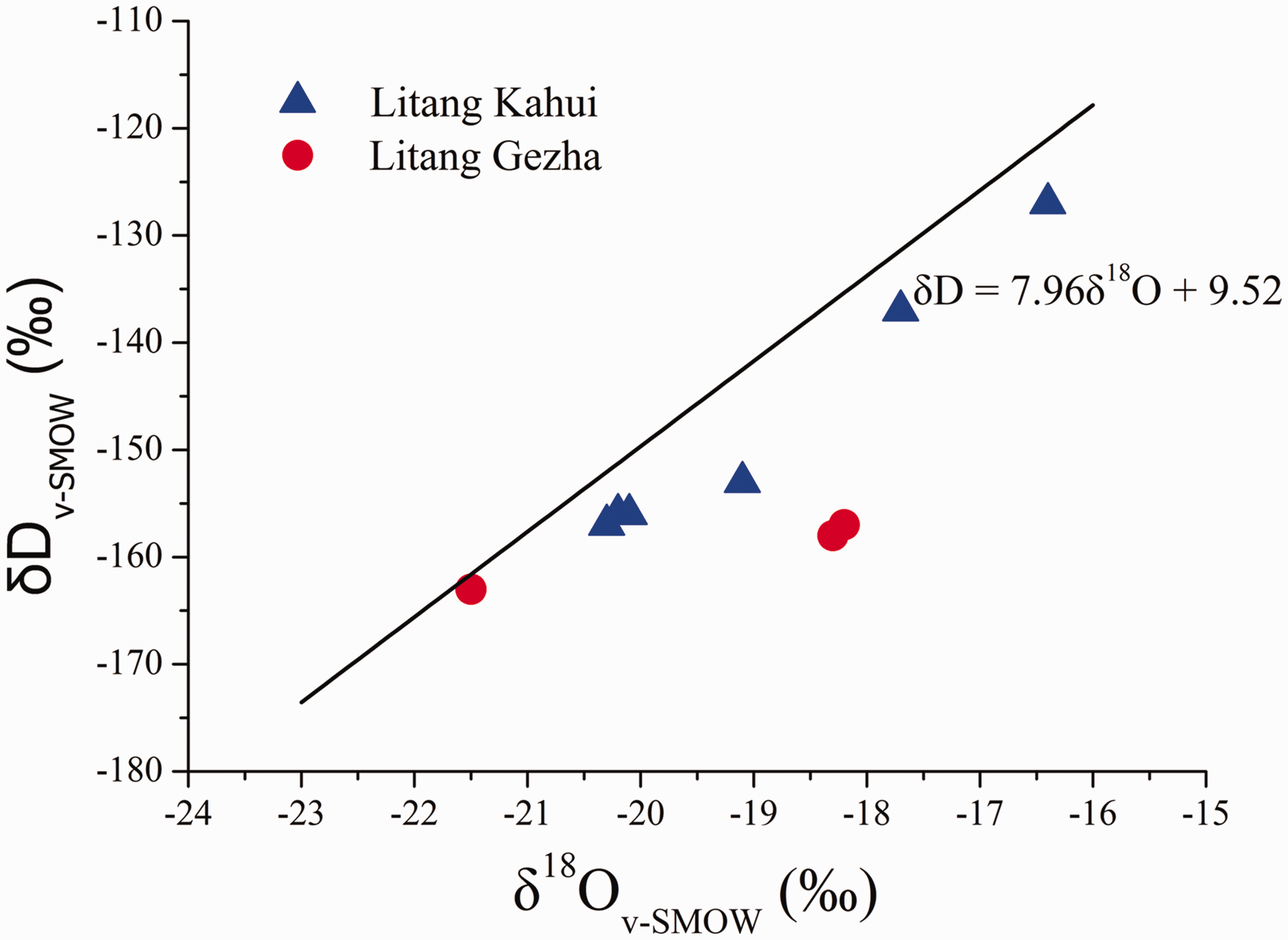
δD-δ18O plot for groundwater of the Litang region. SMOW: standard mean ocean water.
In the figure, the δD and δ18O data points are scattered around and are closely correlated to the line representing meteoric precipitation, indicating that the groundwater is essentially supplemented by meteoric water. In high-temperature water–rock reactions, the δ18O of geothermal water is usually higher than that observed for precipitation recharge, leading to oxygen shift (Sun et al., 1992). In the data shown for the region, most δ18O values lie to the right of the meteoric line, indicating melted ice and snow as another recharging source, high temperatures in the deep thermal reservoir of the Litang region, and long-term groundwater runoff. The prolonged retention and circulation of geothermal water underground encourages oxygen isotope exchange between the water and the surrounding oxygen-containing rocks (Ni et al., 2016), resulting in 18O enrichment of the water. Most of the samples from Gezha show relatively large shifts to the right on the diagram, which is potentially attributable to the location of this geothermal field on the Jinchanggou and Yahuo–Zhuoxi faults, both of which present strong compressive characteristics and crushed zones extending tens or hundreds of meters in width that have undergone repeated geological activity. In addition, the Yahuo–Zhuoxi fault cuts deeply into the mantle, which heats downward migrating low-temperature water that then moves up along the fault zone to form hot springs, lengthening the groundwater runoff time and increasing the extent of water–rock reaction to further enrich the 18O content.
Characteristics of gases from geothermal reservoirs
To determine the sources of geothermal fluids in the Litang region, the gases emitted from geothermal borehole Zk01 were subjected to chemical analysis. Table 2 shows that the gas composition of the geothermal reservoir differs significantly from that of the atmosphere in that the water has CO2 as the main gaseous component and relatively low O2, CO, Ar, N2, and CH4 content, indicating the formation of geothermal fluids in a strongly reducing environment.
Gas composition of geothermal springs in the Litang region.
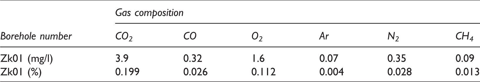
The CO2 constituting the dominant component of gas from the geothermal reservoir (0.199%) could originate from two sources. The first is release during the metamorphism of carbonate mineral-containing rocks under the action of deep thermal sources in which mineral rocks (such as limestone and dolomite) decompose and produce CO2. The SiO2 and CaCO3 in siliceous limestone can be transformed to wollastonite under high temperatures and pressures, producing CO2. Many types of impure limestones, in particular silica-containing dolomite and limestone, usually have CaO–MgO–SiO2–CO2–H2O as components. As these rocks metamorphose, talcum is formed, followed by tremolite, diopside, and wollastonite as the temperature increases. As each original mineral is converted, CO2 is released. The corresponding chemical reactions are given by


The CO2 produced at these deep locations rises along various cracks and pores, with some of the gas emitted directly at the surface and some through hot springs. A large quantity of CO2 dissolves in high-pressure deep groundwater and is released when pressure drops as the water rises to shallow aquifers or emerges from the ground surface as springs, resulting in intense gas bubbles composed mainly of CO2.
The second source of CO2 is direct production by magma. At least four gas spheres are present in the Earth’s interior, with the deeper ones containing more gas. The CO2-rich mantle ichor contains more CO2 gas than water. Magmatic CO2 is dissipated from active volcanic areas and deep fault zones.
The CO concentration of Litang geothermal water is 0.32 mg/l, indicating a strongly reducing environment. During the migration of deep-derived gases, such as the carbon dioxide (CO2) generated by magma from the deep mantle, decomposition takes place in rock bodies containing carbonate minerals, producing new carbon dioxide (CO2) and a small amount of carbon monoxide (CO) as reduction occurs at the carbon sources. The CO is released with CO2 at the ground surface.
Argon gas in the geothermal water is primarily derived from the Earth’s radioactive elements, while N2 comes from two sources: (1) radioactive nuclear reactions and (2) as primary N2 from the deep crust and upper mantle. The average flux of nitrogen emission from the Earth’s interior into the atmosphere is only 23 g/km2 and is very unevenly distributed, mostly occurring in earthquake and deep fault zones.
Large quantities of natural gas with various CH4 concentrations are often discharged from the Earth’s interior to the upper crust and ground surface. This CH4 is either synthesized from inorganic sources such as CO2/CO and H2 in the crust at high temperature and with iron group elements (Fe, Co, Ni, etc.) as catalysts or was present in the primitive atmosphere of the Earth and “absorbed” into and stored by the mantle and crust as the planet formed. During subsequent deep faulting and stratum formation, this fossil gas is released and discharged to the Earth’s surface in different forms and at various scales.
As explained in the above gas formation analyses, geothermal fluids are produced by high-temperature hydrothermal systems. The gases from hot springs are formed at great depth, and their production is related to the genesis of mantle-derived magma, metamorphism, and deep fault structures.
Analysis of deep geothermal processes
Calculation of thermal reservoir temperature
Conventional geothermometry calculation employs either solubility equilibria between minerals and hydrothermal water or geochemical thermometer measurements. The former approach applies functional relationships between temperature and the concentrations of certain minerals in geothermal water to calculate a thermal reservoir temperature, while the latter approach uses known relationships between the ratios of mineral components in geothermal water and aquifer minerals at chemical equilibrium to determine the thermal reservoir temperature. The chemical components used as thermometers should be present in adequate concentrations and not diluted by cold water as they rise to the ground surface. If cold water mixing occurs, the silica-enthalpy model can be applied to eliminate its influence before calculating the thermal reservoir temperature.
Determining water–rock mineral equilibrium
In applying geothermometry to determine a thermal reservoir temperature, at least one substance in the geothermometer must be at equilibrium with the minerals of the thermal reservoir (Zheng and Liu, 1996). If the thermal reservoir temperature is too low, shallow cold water is mixed in, or other chemical reactions occur, equilibrium might not be reached between the chemical components acting as the geothermometer and the minerals in the thermal reservoir. It is therefore necessary to check the equilibrium state of the geothermal water–minerals system to justify the reliability of the chosen geothermometer. A Na–K–Mg ternary plot is generally used to evaluate water–rock equilibrium and distinguish different types of water samples. Figure 6 shows the equilibrium state of the geothermal water in the Litang region. The majority of the samples contain partially equilibrated or mixed water with some immature water. The samples from the Kahui geothermal field show equilibrated or mixed water, indicating some mixing with shallow cold water that will result in errors in the geothermometric thermal reservoir temperature calculation.
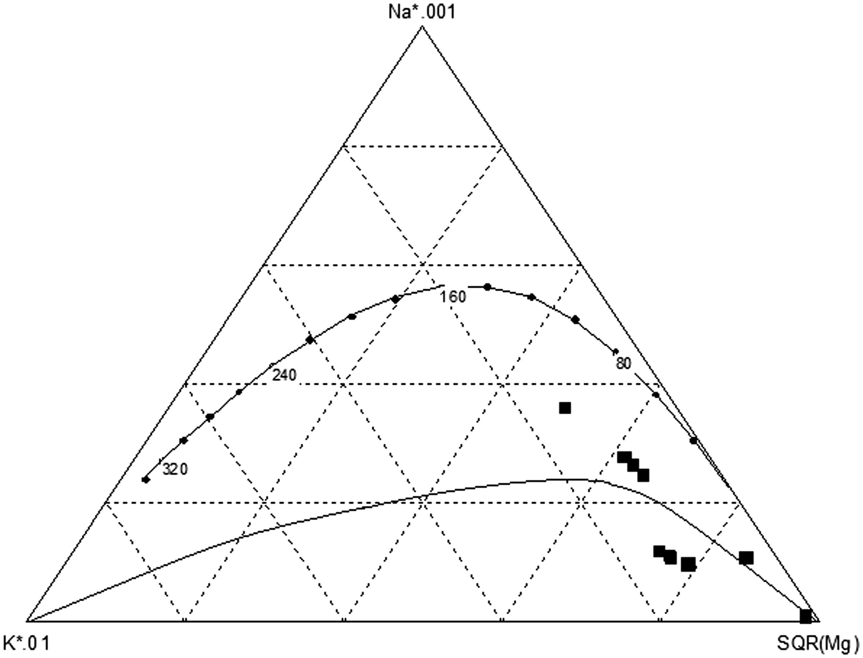
Na–K–Mg ternary diagram of groundwater of Litang region. SQR: square root.
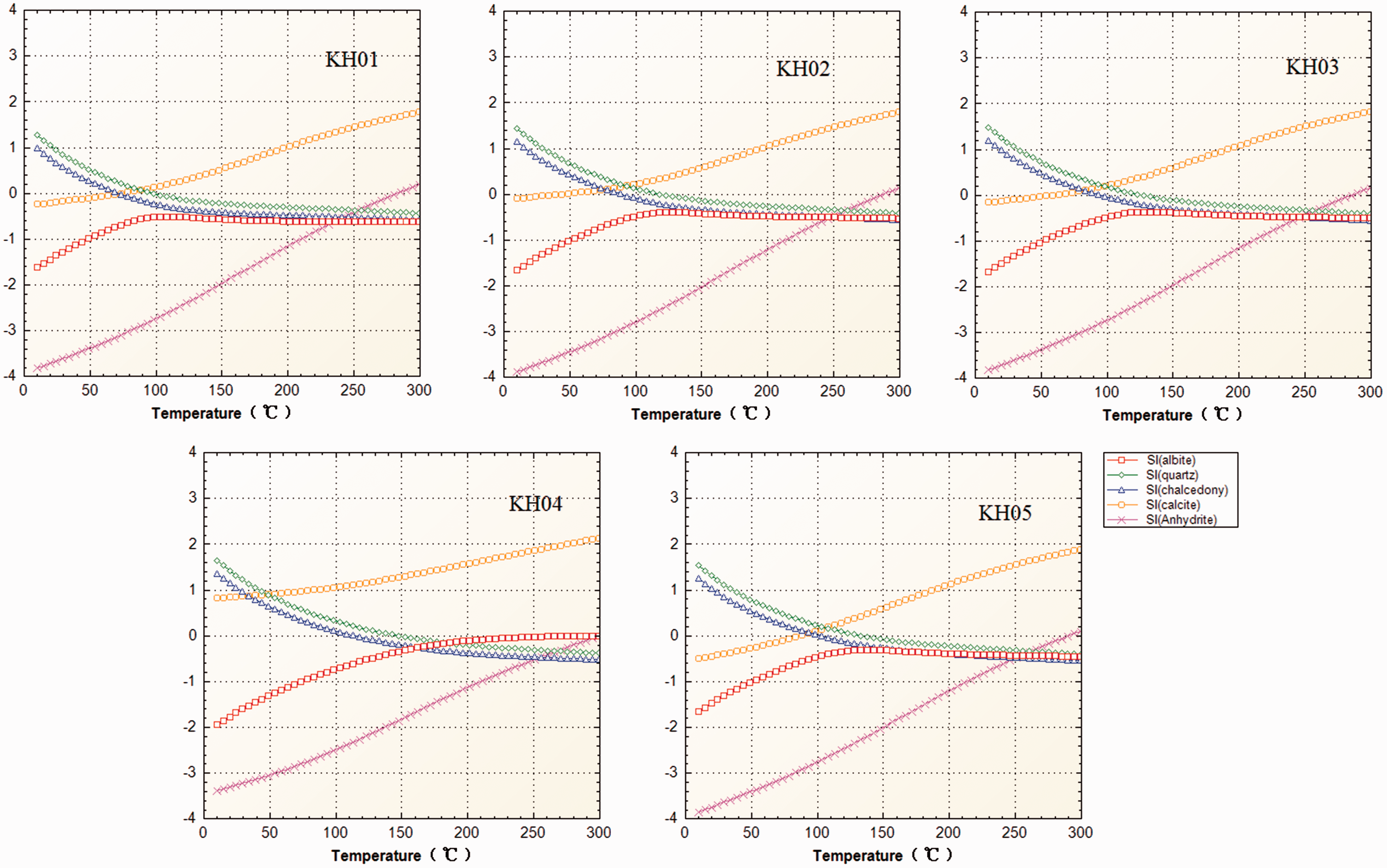
SI–T plots for the minerals of Kahui, Litang.
Geothermometry calculation
The solubility equilibrium of the mineral–hydrothermal water mix of a geothermal system can be used to analytically relate the dissolution of minerals in the hydrothermal solution to temperature, with the temperature at which the hydrothermal solution reaches equilibrium with the minerals regarded as the temperature of the deep thermal reservoir (Chai et al., 2010). The saturation index (SI) is used to determine the degree of saturation of the minerals: minerals are saturated in the hydrothermal solution if SI = 0, oversaturated if SI > 0, and unsaturated if SI < 0 (Guo and Song, 2005). The SIs of the minerals were computed using PREEQC software to develop plots of SI against temperature for the respective mineral–hydrothermal solution systems at equilibrium and derive the current thermal reservoir temperatures of the geothermal fields. As sandstone, along with a significant presence of calcite, constitutes the primary subsurface rock composition at Kahui, calcite, quartz, chalcedony, albite, and anhydrite were selected to perform the calculations. 2. Using geochemical thermometers
It is seen in the Figure 7 that four of the five minerals intersect with the SI = 0 line. Because the trend lines of quartz and chalcedony are close to the equilibrium line, while those of calcite and chalcedony intersect near the equilibrium line, the SI–T curve of chalcedony was used to estimate the thermal reservoir temperature. For sampling sites KH01–KH05, the chalcedony temperatures at SI = 0 of approximately 72°C, 89°C, 94°C, 100°C, and 100°C, respectively, were established as the estimated thermal reservoir temperatures of the respective sites.
There are two types of common geochemical thermometers currently in use: silica geothermometers, such as quartz, chalcedony, etc., and cationic geothermometers, such as Na–K, Na–K–Ca, etc. (Wang and Chai, 2009). The Western Sichuan area studied here is of the rifted mountain geothermal type and is an example of a zoned (vein-type) thermal reservoir. The thermal reservoir temperatures of the geothermal wells and hot springs were therefore calculated using SiO2, Na–K, and Na–K–Ca geothermometers, with the results listed in Table 3.
Thermal reservoir temperatures of Kahui calculated using the geothermometer method.
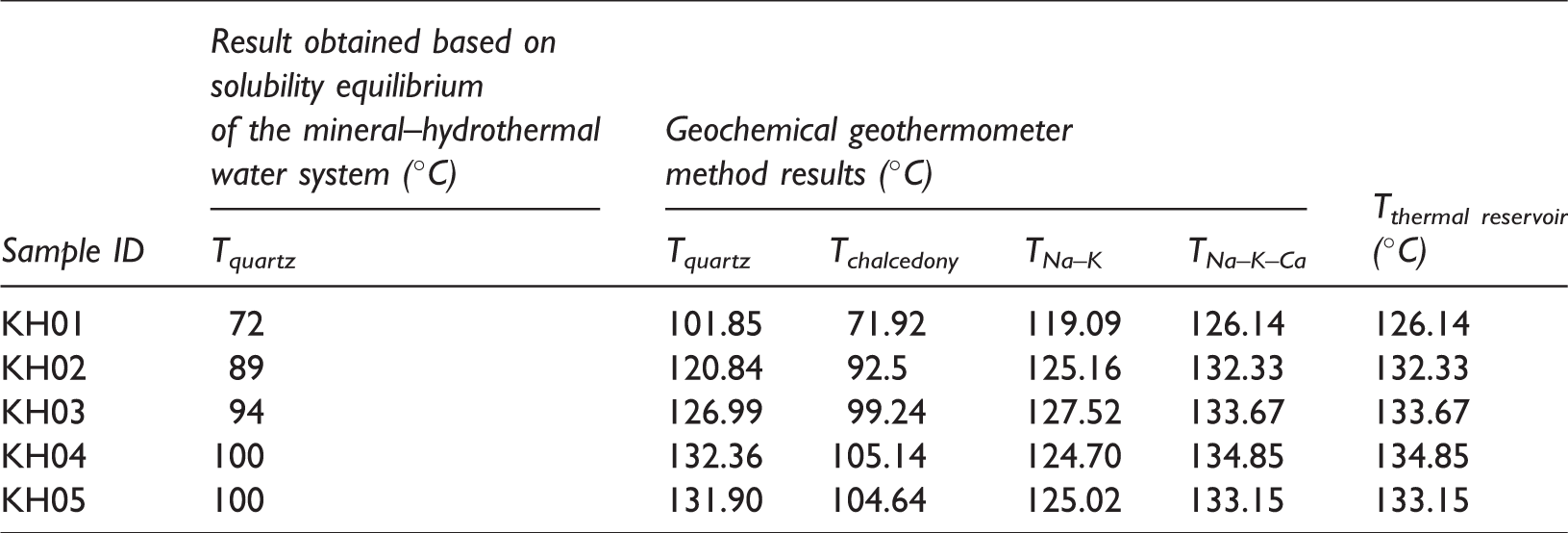
As sampling in the study area was conducted mostly in the river valley and on the flood plain, varying degrees of cold water mixing into the geothermal water was unavoidable, resulting in diluted SiO2, K+, Na+, and Mg2+ concentrations. The Litang region is situated on the southeastern border of the West Sichuan Plateau and is a medium/high-temperature geothermal resource. In light of these conditions, we determined that a Na–K–Ca thermometer would be most accurate in representing the thermal reservoir temperature.
Silica-enthalpy mixing model
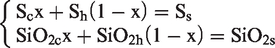
As was shown in “Determining water-rock mineral equilibrium” section, the hot springs sampled in the Kahui geothermal field contain either partially equilibrated or mixed water, with possible cold water mixing. The silica-enthalpy model and equations (Tong et al., 1981) were therefore applied to eliminate the effect of mixing through calculation of the cold water mixing ratio and the thermal reservoir temperature prior to mixing
The relationship between the enthalpy, SiO2 concentration, and temperature of the saturated water is shown in Table 4. When the temperature is below 100°C, the enthalpy of the saturated water equals the temperature value. The cold spring used in this calculation is KH06, which has a temperature of 8.7°C and a SiO2 concentration of 12 mg/l.
Relationship between temperature, enthalpy, and SiO2 concentration.
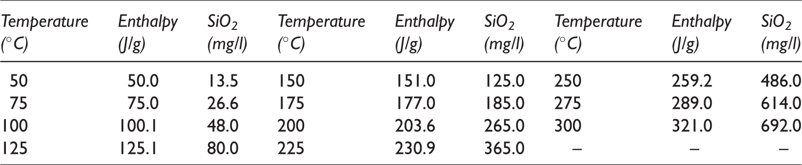
The respective functional relationships between enthalpy and SiO2 content and temperature are plotted in Figure 8 using the equations of the silica-enthalpy model. The intersection of the two curves gives the cold water mixing ratio. As seen in the figure, the cold water mixing ratios of KH01–KH05 are approximately 68%, 61%, 61%, 64%, and 60%, respectively, while their respective thermal reservoir temperatures are 152°C, 173°C, 176°C, 195°C, and 180°C.
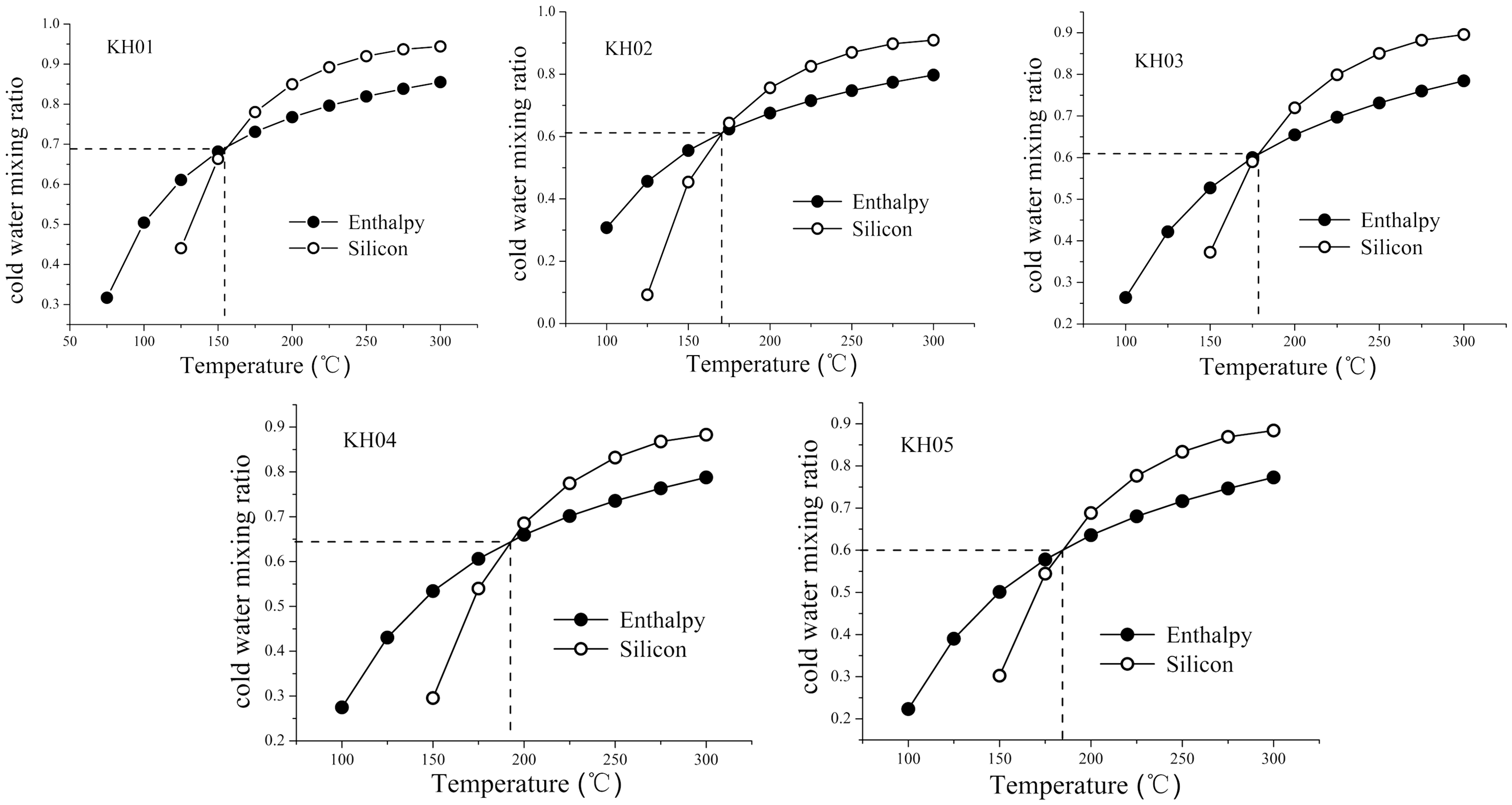
Silica-enthalpy models of springs in Kahui, Litang.
The thermal reservoir temperatures calculated using the silica-enthalpy model differ significantly from those calculated using geothermometry. This disparity can be attributed primarily to the mixing of surface cold water into the rising geothermal water, which establishes a new equilibrium in the mid-layer thermal reservoir and therefore groundwater sample geothermometry results that reflect the altered temperatures at this depth. The effect of cold water mixing is removed in the silica-enthalpy model, which therefore more accurately reflects the temperatures of deep thermal reservoirs. There remain some uncertainties in the thermal reservoir temperatures calculated using the silica-enthalpy model because the method depends on the content of SiO2 in the hot spring water, which can be overestimated as a result of the loss of steam as the water undergoes thermal expansion prior to cold water mixing (Tong et al., 1981). Nevertheless, the silica-enthalpy model considers different scenarios more comprehensively than geothermometry, and SiO2 content is a comparatively accurate index, making it the more reliable method for calculating thermal reservoir temperature.
Thermal cycle depth calculation
The geothermal resources of Western Sichuan are of the rifted mountain type. The Kahui geothermal field, in particular, is primarily influenced by tectonic and geomorphologic factors (Luo et al., 2016), with a geothermal water temperature that is positively correlated with the thermal cycle depth of the reservoir, as represented by the following equation
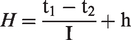
Records show an annual average temperature of 3°C for the Litang region, a geothermal gradient of 4.75°C/100 m, and a constant temperature zone thickness of 20 m (Cao, 2010). The calculated thermal depths are shown in Table 5. As a result of the cold water mixing occurring with the upward motion of geothermal water, the hot spring water samples acquired for this study were in non-equilibrium or partial equilibrium states. The thermal cycle depths calculated using the thermal reservoir temperatures obtained via geothermometry correspond to mid-layer thermal reservoir depths. Only after correction by the silica-enthalpy model did the thermal cycle depths reflect the actual depths of the deep thermal reservoirs.
Thermal cycle depths calculated for the geothermal reservoirs of Kahui.
For example, the initial temperature and thermal cycle depth of the deep thermal reservoir at sampling site KH01 were 152°C and 3156.84 m, respectively. With a cold water mixing ratio of about 68% into the rising geothermal water, the temperature was reduced to 126.14°C by the time it reached the mid-layer thermal reservoir, resulting in a modified thermal cycle depth of 2612.42 m. Similarly, the initial temperatures of the deep thermal reservoirs at sites KH02–KH05 were 173°C, 176°C, 195°C, and 180°C, respectively, with thermal cycle depths of 3598.95, 3662.11, 4062.11, and 3746.32 m, respectively. The rising geothermal waters at the sites were subject to 61%, 61%, 64%, and 60% cold water mix-in, respectively, reducing the mid-layer thermal reservoir temperatures to 132.33, 133.67, 134.85, and 133.15°C, respectively, and the thermal cycle depths to 2742.74, 2770.95, 2795.79, and 2760 m, respectively.
Analysis of water–rock interaction
Hydrogeochemical simulation, including forward and inverse geochemical modeling, can be used to study the temporal evolution of deep groundwater and demonstrate the geochemical processes of deep-Earth water–rock interaction (Wang, 2017).
In this study, PHREEQC simulation software was used to conduct modeling of water–rock interaction in the Litang region. In an attempt to more accurately reflect the topographic and geological features of the region, lower and higher altitude hot spring sampling sites were used as starting and ending points for inverse hydrogeochemical simulation. The modeled path in the Kahui geothermal field was therefore from KH04 to KH03, while that in the Gezha geothermal field was from GZ04 to GZ02 (see Table 6). The strata of the Litang region primarily comprise various types of volcanic rocks such as volcanic conglomerate, metasandstone, argillaceous slate, etc., of which the dominant mineral compositions are albite, illite, calcite, anorthite, dolomite, anhydrite, quartz, and fluorite, all of which can participate in the simulated reactions. Cation exchange and adsorption can also take place during the formation of spring water, introducing NaX and CaX2 as the two exchange reaction entities.
Hydrochemical compositions of samples estimated by inverse hydrogeochemical modeling of reaction paths.
Optimal solutions based on the geothermal conditions and mineral compositions of rock samples in the study area were then selected from the PHREEQC simulation results, and the resulting simulated paths for the Kahui and Gezha geothermal fields are shown in Table 7.
Inverse hydrogeochemical simulation results.
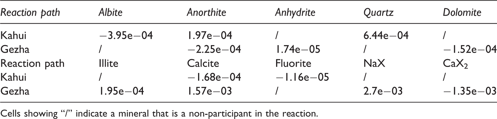
Cells showing “/” indicate a mineral that is a non-participant in the reaction.
According to the simulation results, albite precipitation occurs during migration of fluid within the Kahui geothermal field, resulting in a decline in Na+ levels and an increase in Ca2+ concentrations as a result of anorthite dissolution of calcite and fluorite precipitation. The precipitation of calcite reduces the amount of HCO3, while the precipitation of fluorite decreases the level of F−. The dissolution of quartz and the precipitation of silicate lower the SiO2 content. During geothermal fluid migration within the Gezha geothermal field, the following processes take place: dissolution of illite into the groundwater, which increases K+ concentration; cation exchange, which alters the amount of Na+; dissolution of anhydrite and calcite, precipitation of dolomite and anorthite, and cation exchange, all of which lower the level of Ca2+; dissolution of illite and precipitation of dolomite, which reduce Mg2+ content; dissolution of calcite and precipitation of dolomite, which increase HCO3 concentration; and anhydrite dissolution, which causes a rise in SO42−, and, under the influence of silicate, an increase in SiO2 concentration.
The chemical composition of the hot springs in Litang is predominantly affected by calcite precipitation and the presence of silicate. Analysis of the simulated reaction paths revealed that the migration of geothermal water is accompanied to a certain extent by the precipitation and dissolution of minerals. As geothermal water from deep thermal reservoirs travels to the ground surface, complex processes such as boiling, evaporation, concentration, cold water mixing, etc. can occur, even though such hydrochemical evolutions occurring within a given area may not be immediately noticeable as a result of the short reaction paths.
Conclusions
The 11 samples examined in this study revealed that groundwater in the Litang region of Western Sichuan is primarily of the HCO3Na type, with a few cases of HCO3Na–Ca and even fewer HCO3SO4–Na types. The strong positive correlation of Sr2+ and Li+ with Cl− in the region indicates the origin of these two cations from deep-Earth matter in addition to mineral dissolution. The groundwater throughout the region has relatively high concentrations of Na+ and metaboric acid, indicating longer lived underground runoff and slower migration. The δD and δ18O values obtained through isotopic analysis of the two geothermal fields are in the vicinity of the meteoric precipitation line, revealing atmospheric precipitation as the main replenishment source of geothermal water. An oxygen shift is seen in the Gezha geothermal field as a result of water–rock interaction and oxygen isotope exchange taking place between water and oxygen-bearing surrounding rocks during the long, slow groundwater flow. Slow groundwater flow also accounts for the higher ion concentrations observed within the Gezha geothermal field. Mineral–water solubility equilibrium and ion geothermometry results revealed Kahui geothermal field mid-layer thermal reservoir temperatures and thermal cycle depths ranging from 126°C to 135°C and 2600 to 2800 m, respectively. The cold water mixing ratios calculated using the silica-enthalpy model ranged from 60% to 68%, with deep thermal reservoir pre-mixing temperatures and thermal cycle depths of 152°C–195°C and 3156–4070 m, respectively. The silica-enthalpy model yielded higher thermal reservoir temperatures for the Kahui geothermal field than the geochemical thermometer method because the latter approach leads to the underestimation of the water temperature in deep geothermal reservoirs in which cold water is mixed during upwelling. This effect is eliminated by the silica-enthalpy model, resulting in more accurate temperature estimates for deep thermal reservoirs. The variation in Na+, HCO3, and SiO2 concentrations during the migration of groundwater in the Litang region is quite large. The characteristics of the Kahui geothermal field are primarily affected by albite and calcite precipitation and the presence of silicate, while those of the Gezha field are primarily affected by calcite dissolution, dolomite precipitation, and the presence of silicate. The migration of geothermal water is accompanied by a certain amount of mineral precipitation and dissolution. As hot water from deep thermal reservoirs reaches the ground, complex processes such as boiling, evaporation, concentration, and cold water mixing can occur. However, hydrochemical evolutions such as these occurring within a given area may not be immediately noticeable owing to their short reaction paths. The geochemical characteristics of geothermal water in Litang reflect the deep geothermal processes occurring in the region. Meteoric water circulating along rock fissures deep within the Earth is heated by various heat sources to form deep geothermal water, which carries along deep paleowater during its upward movement. Deep faults increase the length of longitudinal circulation and runoff, thereby slowing the flow. Geothermal water therefore has abundant time for ion exchange with the surrounding rocks deep within the Earth. Albite and calcite are precipitated in the Kahui geothermal field, and geothermal water reacts fully with silicate. Calcite dissolution and dolomite precipitation occur in Gezha, with the geothermal water also fully reacting with silicate. In both cases, the water eventually rises back to the surface under hydrostatic pressure and thermodynamic force. In this process, cold surface water is mixed in, and eventually hot springs are formed at the surface. Based on real, reliable geothermal data obtained in the Litang region of Western Sichuan, the hydrogeochemical characteristics, thermal reservoir temperatures, and thermal depths of the Kahui and Gezha geothermal fields were comprehensively analyzed in this study. In addition, modeling results systematically revealed the deep geothermal processes in the region, adding further detail to the current understanding of the geothermal genesis of Western Sichuan. Through these efforts, a new understanding of the chemical processes of deep resources, in particular, geothermal water, has been developed to fill the gaps in the knowledge of deep geothermal processes in the Litang region. The results also provide useful guidance for future drilling efforts. When drilling in the presence of thermal reservoirs, boreholes will often not be directly located over the reservoir, which can lead to unrealistically low-temperature readings. To correct for this, a variety of geothermal indices reflecting the hydrogeological conditions, such as those analyzed in this study, should be considered during the pre-drilling evaluation process.
Footnotes
Declaration of conflicting interests
The author(s) declared no potential conflicts of interest with respect to the research, authorship, and/or publication of this article.
Funding
The author(s) disclosed receipt of the following financial support for the research, authorship, and/or publication of this article: This work was financially supported by the National Natural Science Foundation of China (no. 41502249), Chinese Academy of Geological Sciences fund (no. SK201501), and Basic scientific research service fee project of the Chinese Academy of Geological Sciences (no. JYYWF20181101).