
Abstract
Weathered-crust karst carbonate is developed in the third submember of the fourth member of the Middle Triassic Leikoupo Formation (Lei43 submember) in the Longgang area of Sichuan Basin, China, and acts as an important oil and gas reservoir. To reconstruct the paleogeomorphology of the weathered-crust karst, we analyzed the seismic thickness of the interval from the erosional unconformity surface on the top of the Leikoupo Formation to the karst at the bottom of the third member of the Xujiahe Formation (Xu3 member), based on existing three-dimensional seismic and drilling data, and the sedimentary characteristics of the Leikoupo and Xujiahe formations. There are three secondary types of geomorphological unit, namely the karst highlands, the karst transitional zone, and the karst basin, and these have distinct karst water development patterns and hydrological conditions that determine the intensity of karstification and reservoir quality. Among them, the karst highlands have a poor reservoir capacity due to their long-term exposure above the water table, which resulted in severe denudation. The karst transitional zone features the superimposition of multiple periods of strong karstification, and this has resulted in high-quality reservoir conditions in the karst monadnocks but poor reservoir conditions in the karren. The karst basin represents a drainage area that experienced weak karstification, and the reservoir capacity is generally poor, although some good reservoirs were developed in shoals. Paleogeomorphological maps provide excellent guides to finding karst monadnocks in karst transitional zones, and monadnocks should serve as the main targets of exploration in the weathered-crust karst reservoir on top of the Lei43 submember.
Introduction
It is widely known that 60% of the total oil and gas reserves worldwide are in carbonate reservoirs (Cao et al., 2010, 2015; Guo and Zeng, 2015; Huang et al., 2015; Morad et al., 2016; Roehl and Choquette, 1985; Shi et al., 2017; Tao et al., 2016; Wang et al., 2015; Wei et al., 2017; Yang et al., 2017), among which weathered-crust karst reservoirs are an important type (Feazel, 2010). Breakthroughs in the oil and gas exploration of such reservoirs have been widely reported for the Anadarko Basin (USA) (Liu et al., 2017; Mazzullo, 1995), the Williston Basin (USA) (Gerhard et al., 1982; Kuhn et al., 2012), and the BuHasa Oil Field (United Arab Emirates). With progress in seismic technology (Arfai et al., 2016; Back et al., 2011; Kolla et al., 2007; Posamentier and Kolla, 2003; Sayago et al., 2012; Sullivan et al., 2011; Zeng et al., 2011) and the study of karst systems (Bacetaet et al., 2007; Cao et al., 2015; Feng et al., 2013; Filipponi et al., 2009; Jin et al., 2009; Li et al., 2008; Loucks, 1999; Loucks and Handford, 1992; Mehrabi and Rahimpour-Bonab, 2014; Palmer, 1991, 1995, 2007; Whiteet et al., 1995; Xiao et al., 2016), the precision of paleogeomorphological reconstructions has gradually improved. Through the fine characterization of karst paleogeomorphology, the relationships between karst geomorphic units and oil and gas have been clarified for the Ordovician strata in the Tahe Oil Field (Li et al., 2016; Zhang, 2001) and the Ordos Basin (Yu et al., 2016; Zhang et al., 2014) in China. The widely and stably distributed weathered-crust karst reservoirs on the top of the Lei43 submember are thought to have huge exploration potential (Ding et al., 2012; Tan et al., 2014; Wu et al., 2017; Zhong et al., 2011). Li (2001) proposed that shoals were the foundation for reservoir development, but Qin and Zou (2012) argued that reservoir quality is controlled by the superimposition of weathered-crust and sedimentary facies, and Zhong et al. (2011) suggested that weathered-crust karst is the key for reservoir formation. Exploration for reservoirs related to weathering crusts has made much progress along the platform-margin of the northwest Sichuan Basin, but no progress in exploration has been made in the central part of the basin, thus hindering further exploration in the Leikoupo Formation. Recent research on the Leikoupo Formation in the Longgang area has shown that intra-platform shoals form the basis of reservoirs, while their distribution is related to karst drainage controlled by paleokarstification (Ding et al., 2012; Li et al., 2011; Qin and Zou, 2012; Zhong et al., 2011). Much detailed research has been conducted on the main factors involved in the genesis and the patterns of the weathered-crust reservoir, while little has been conducted on reconstructions of the karst paleogeomorphology, which means there has been little effective guidance for hydrocarbon exploration. It is critical, therefore, to determine the finer characterizations of the karst paleogeomorphology in order to identify favorable zones for exploration and development.
Geological setting
The study area covers 4000 km2 and is located in the Yilong–Pingchang gentle structural belt of the central Sichuan Basin, adjacent to the Central Sichuan and Kaijiang paleohighs, and linked to the Cangxi Depression in the northwest and the Southeast Fold Belt in the southeast (Figure 1). This study examines the Middle Triassic Leikoupo Formation, which comprises a set of marine carbonate deposits that formed during late Indosinian tectonism. At this time, the study area was uplifted along with the Upper Yangtze Platform, and a long period of shallow-water carbonate deposition that began in the Ediacaran came to an end, followed by erosion and denudation (Mei, 2010; Mei and Liu, 2017).
Regional structural map and stratigraphy of the Lei4 member in the Sichuan Basin.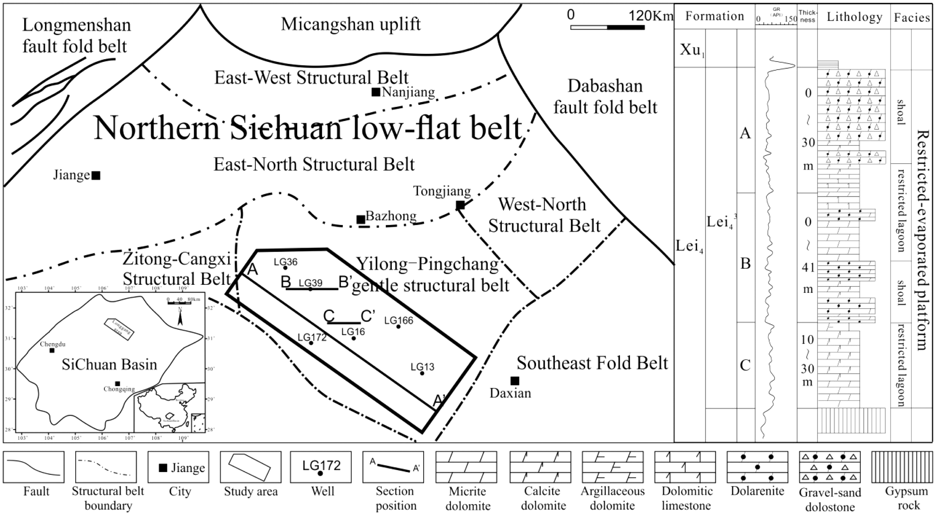
The Leikoupo Formation in the Longgang area is a set of deposits consisting of irregularly alternating marine carbonate and evaporate successions, and it is generally divided into four lithological sections. The Lei4 member is mainly a set of dolostones interbedded with limestone and gypsiferous rocks, and it unconformably underlies the Xujiahe Formation and conformably overlies the Lei3 member. Lei43 can be further divided into three single layers (Lei43A, Lei43B, and Lei43C) according to their lithological characteristics, electrical response, and reservoir development (Figure 1). Lei43A consists mainly of gray gravel and sand-grain-sized dolostone, micrite to silty-dolostone, karst breccia, and occasional oolitic dolostone, and Lei43A is absent in some areas due to strong denudation. Lei43B is mainly a set of micrites, with small amounts of granular dolostone and pinhole dolostone. Lei43C consists predominantly of micrite and micritic dolostone.
Methods and techniques
Principles and methods of paleogeomorphological reconstruction
At present, the main methods used for karst paleogeomorphological reconstruction include the cast thickness method, the residual thickness method, the sequence stratigraphic method, and the back-stripping method (Deptuck et al., 2007; Jin et al., 2017; Sawyer et al., 2007; Wen et al., 2009; Xiao et al., 2014), but each method has its limitations. In the present study area, gypsiferous rocks are widely developed, but they were intensely deformed during the Indosinian (Ling et al., 2012), making it difficult to determine the original depositional thicknesses. This problem is compounded by the vulnerability of gypsiferous rocks to dissolution. Therefore, the residual thickness method has no practical use in the study area. The cast thickness method is much more applicable to the actual geological setting, and the principle of this method is shown in Figure 2.
Principle of the cast thickness method used to reconstruct karst paleogeomorphology.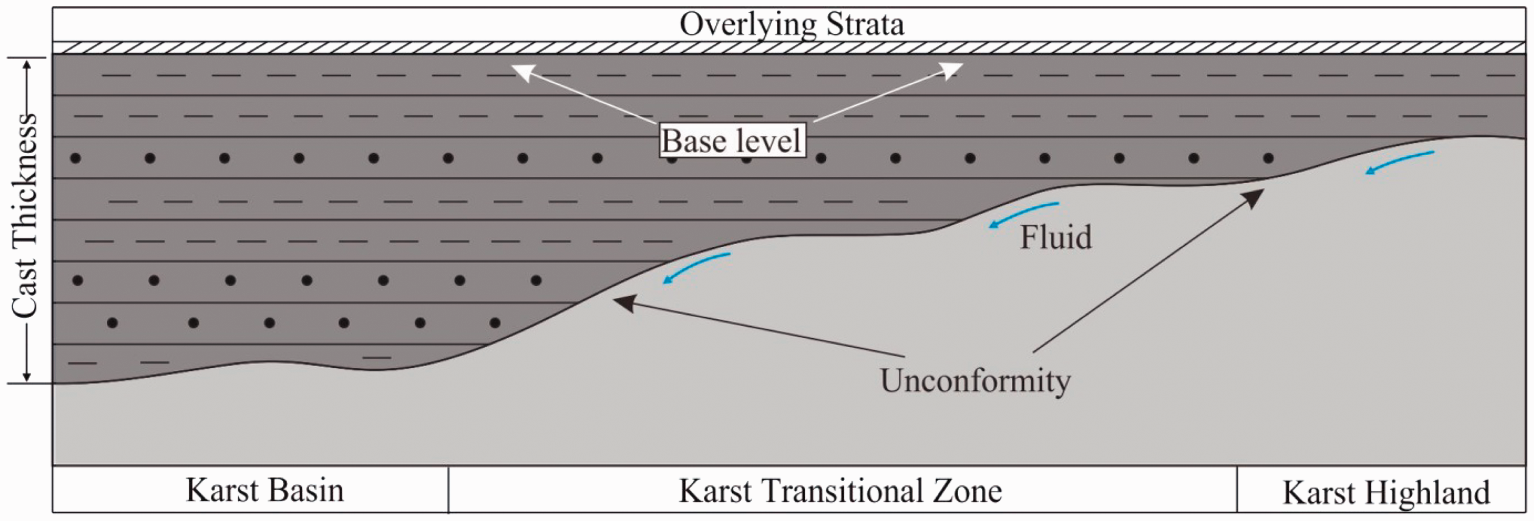
In applying the cast thickness method, the base level we selected was the regional isochronous interface closest to the unconformity in the overlaying strata, and we took the thickness of the strata between the base level and the unconformity as a reflection of the ancient landform. In this context, the variation in thickness of the strata between the unconformity and the overlying marker beds generally reflects the fluctuations in the ancient erosional surface (Figure 2). In other words, thicker overlying strata correspond to areas of lower elevation in the ancient erosional surface, while thinner overlying strata correspond to elevated areas. Thus, a contour map of strata thickness can be used to illustrate the relief of the ancient erosion surface. The identification of the base level should meet the following requirements: (1) it should be a regional isochronous interface; (2) it should be closest to the unconformity; and (3) it should be easily identified, preferably involving a clear change in lithology (Xiao et al., 2014; Zhao et al., 2001).
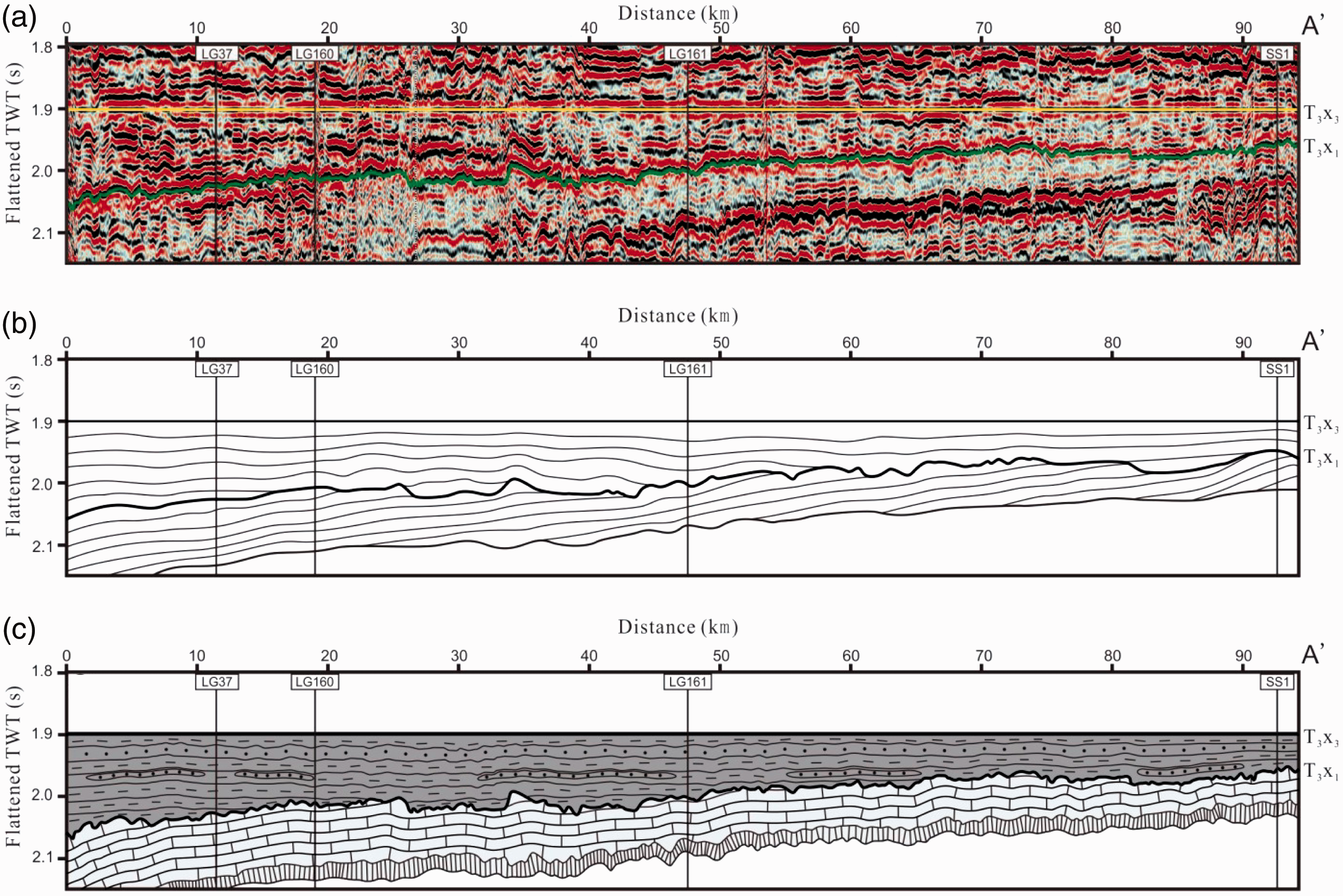
The Xujiahe Formation that overlies the Leikoupo Formation is a set of very thick continental clastic rocks, formed after Indosinian tectonism in the Late Triassic. The Xu1 and Xu2 members fill the lower areas on the unconformity surface, and the Xu3 member is a useful isochronous interface (Gao et al., 2011; Tan et al., 2013; Zhong et al., 2016) that is easily tracked in seismic profiles due to its obvious reflection characteristics and widespread regional continuity (Figure 4). Therefore, according to the principles of base-level selection, the Xu3 member is selected as the base level for making an accurate reconstruction of karst thickness.
Corrections for compaction and tectonic subsidence
In general, increasing the depth of burial will reduce porosity due to compaction. The coefficients of compaction decrease in order of mudstone, sandstone, and carbonate. As the overlying Xujiahe Formation consists mainly of sandstone and mudstone and is strongly affected by compaction; it is necessary to correction for compaction in the strata of the Xu1–3 members.
Based on the method proposed by Guan (1992), 57 wells were selected for reconstructing the original sedimentary thickness, and the data show a highly linear positive correlation between the present and original formation thicknesses (Figure 3). The changes approximately reflect the variations in strata thickness during deposition. It is feasible, therefore, to reconstruct the karst thickness of the karst paleogeomorphology on the top of the Lei43 submember using the present strata thickness.
Correlation diagram of the thickness of the Xu1–3 members before and after correction for compaction and subsidence. Seismic sections of the Leikoupo Formation, Longgang area. (a) Seismic section before flattening of the bottom of the Xu3 member. (b) Section showing the stratigraphic distribution. (c) Schematic lithological section.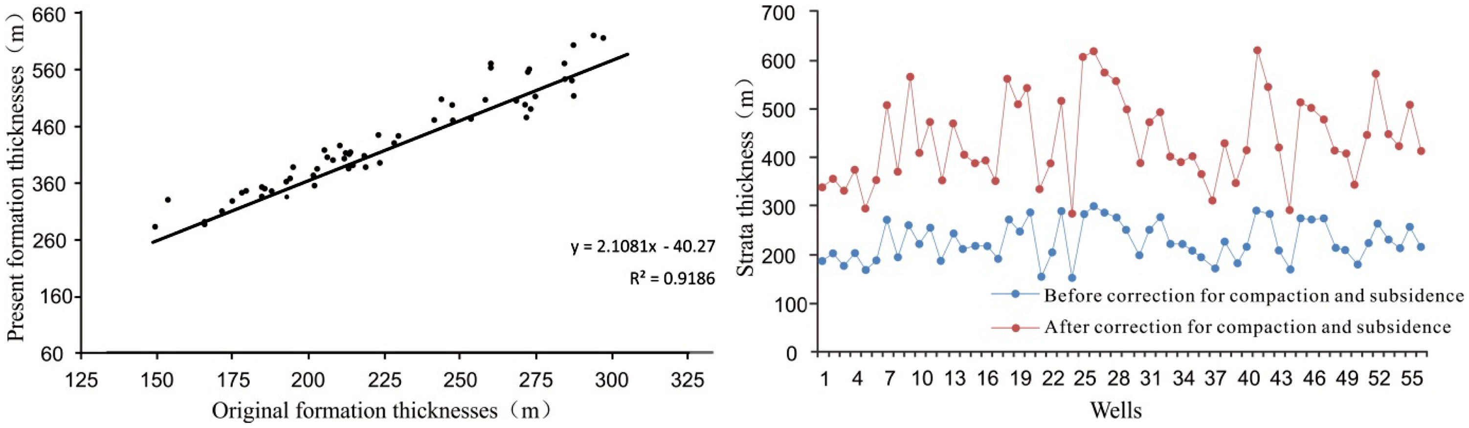
In addition, the differences in topographic relief during the period of sedimentation mean that differential subsidence occurred, which can affect the paleogeomorphological reconstruction. It is necessary, therefore, to consider the effects of tectonic subsidence during the reconstruction. However, although the study area is adjacent to the Luzhou and Kaijiang paleohighs, the influence of these features on the central Sichuan Basin was small, resulting in extremely gentle slopes (0.5° in the northwest and 0.25° in the northeast). It is therefore safe to say that the impact of differential subsidence on the thickness of the strata is extremely small and can be neglected in the reconstruction.
Paleogeomorphological reconstruction of weathered-crust karst on the top of the Lei43 submember
Based on the above analysis, we combined the three-dimensional seismic data and the drilling data in the study area to accurately identify and track the bottom of the Xu3 member and the top of the Leikoupo Formation. This allowed us to build a stratigraphic framework model of the karst paleogeomorphology in a time domain (Figure 4). Our analysis allowed us to determine the differences in the bottom depths of the Xu1 and Xu3 members, thereby yielding the karst thickness between the Leikoupo Formation and the base level. The larger karst thickness corresponds to the karst basin, while the smaller karst thickness corresponds to the karst highlands. Then an iterative method was adopted to calculate the interval velocity for time–depth conversion. Thus, a karst map of the karst paleogeomorphology can be constructed (Figures 6 and 7). We divided the study area into two regions in order to characterize the karst geomorphological units more precisely, and in this paper, we present the results using a hierarchical display method.
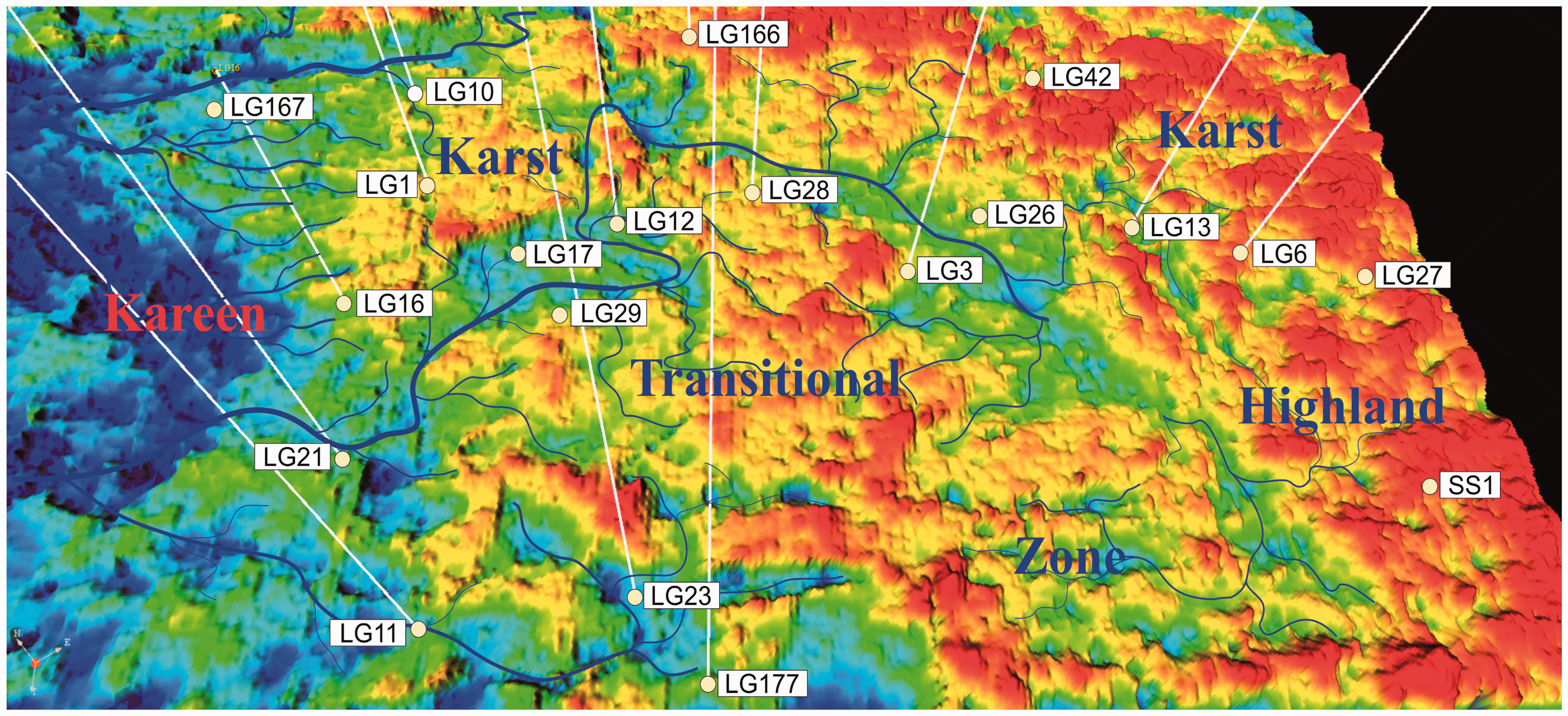
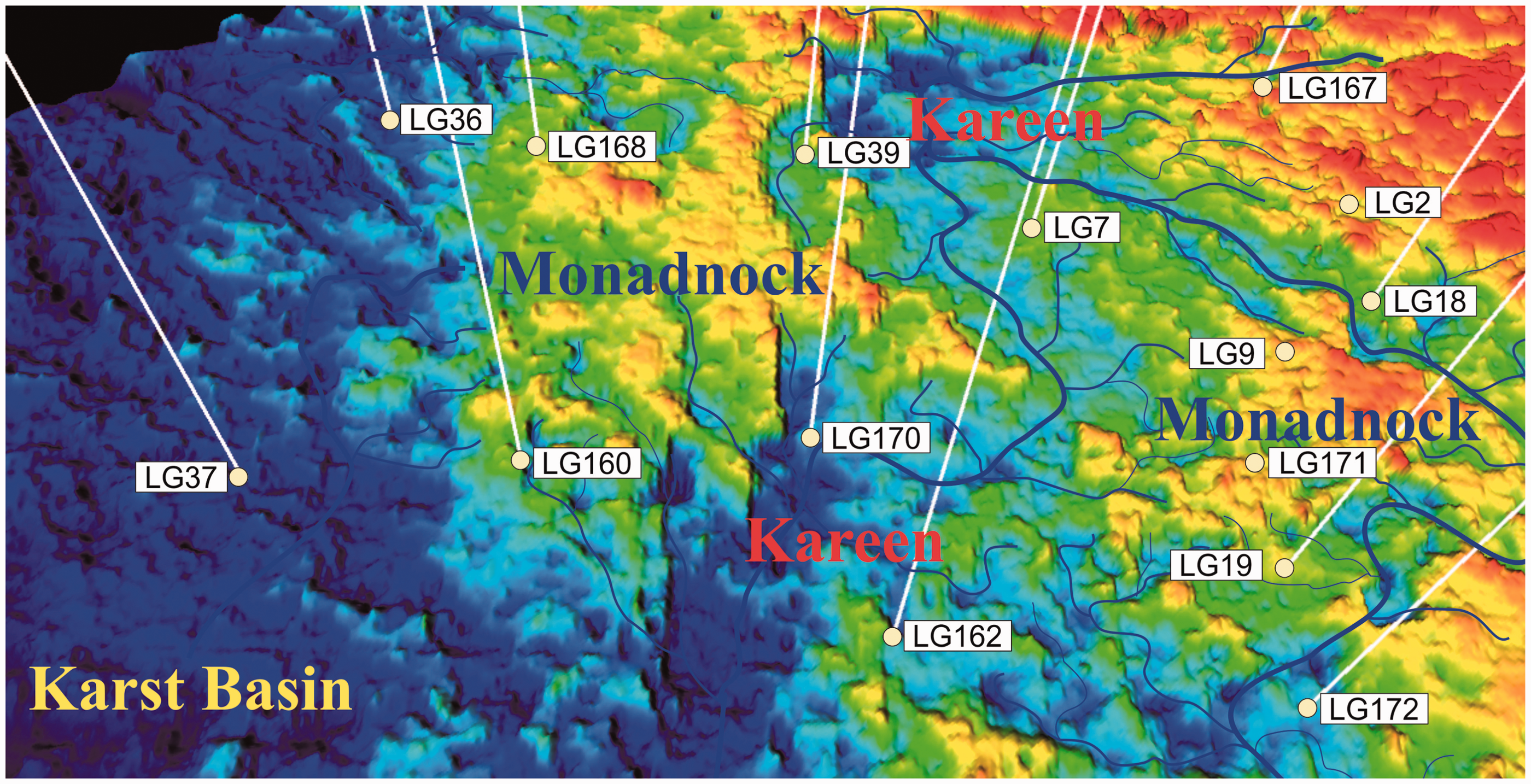
Reflection features of seismic sections B–B′ and C–C′ (the locations of the sections are shown in Figure 1). Superimposition of the karst water system and the reconstructed paleogeomorphology on top of the Leikoupo Formation in the Longgang area (eastern part). Well locations are shown. Superimposition of the karst water system and the reconstructed paleogeomorphology on top of the Leikoupo Formation in the Longgang area (western part). Well locations are shown.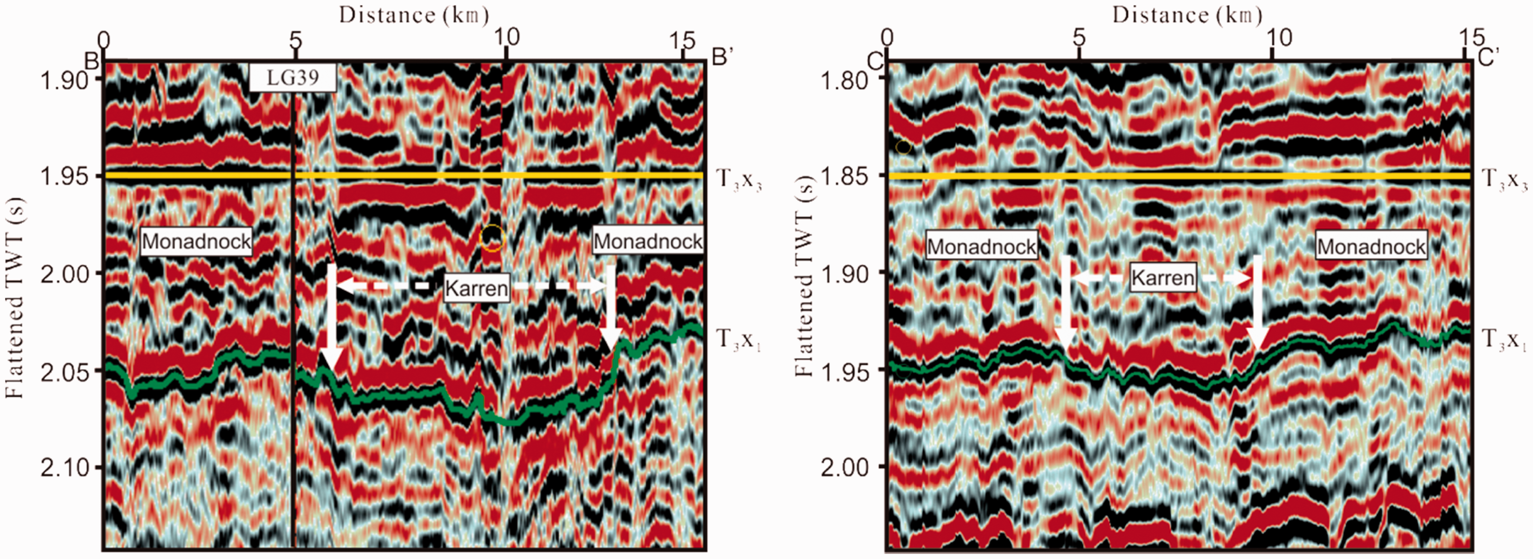
Results
Characteristics of the paleogeomorphology
The paleogeomorphology of the study area shows a step-down pattern from northeast to southwest (Figure 6). Karst highlands occur mainly in the east near Wells LG166 and SS1, with little topographical variation. Medium and small ponors occur near Well SS1. Moreover, a northwest–southeast trending karren occurs in the area between Wells LG3 and LG26 (Figure 6), and an obvious overlapping can be identified in the seismic section. In the east, near Wells LG166 and SS1, there are inclined peak-cluster-shaped valleys that separate the transitional zone into different geomorphological units. The western part of the area near Well LG37 is low with a flat, even topography and occasional mounds (Figure 7).
The drilling data indicate that the formation thickness of the Lei4 member in the karst highland is generally small, and that denudation due to weathering was severe, leading to the complete removal of parts of the Lei43 submember. The strata in the basinal area are relatively well preserved, and the formation thicknesses in the karren and the monadnocks are generally thinner than the average. Overlapping is apparent in the strata overlying the karren in the seismic section (Figure 5), which validates the argument that the early clastic sediments first filled the lower areas on the top of the Leikoupo Formation.
Division into paleogeomorphological units
Three types of secondary karst morphological units were identified in the study area according to their elevations, topographic slope angles, and karst water system distributions, as well as the relative development of the different geomorphological units (Jin et al., 2017; Mayer et al., 2003; Wegmann and Pazzaglia, 2009). The morphological units are karst highlands (seismic time < 0.06 s), karst transitional zones (seismic time of 0.06–0.13 s), and karst basins (seismic time > 0.13 s).
Karst highlands
Karst highlands are geomorphologically high locations, and they are vulnerable to atmospheric fresh-water leaching and weathering denudation because they are beyond the phreatic water table either as a result of tectonic uplift or a fall in the phreatic water table caused by a reduction in atmospheric fresh water. Karst highlands are the main areas of atmospheric fresh water recharging, and the fluids there are mainly laterally eroding and vertically migrating. The hydrodynamic intensity is weak, and horizontal water flow is relatively slow. Vertical seepage is the main mode of karstification, resulting in thick vertical vadose zones and beaded karst cave systems, which are generally filled with muds and sands as well as breccia due to karst cave collapse (Figure 8(b) and (c)). The intensified surface karstification and karst cave collapse can result in large ponors, such as those in the area near Well SS1. These ponors can be connected to the underground river near the phreatic water table that provides water for the lower karst geomorphological units.
Photographs of cores of the Lei43 submember karst rocks in the Longgang area. (a) Brown–gray rubble dolostone, alluvial breccia filling the karst cave, argillaceous siltstone filling the inter-breccia part, Well LG19, 3–3/103. (b) Calcirudite, Well LG166, 4052.67–4052.97 m. (c) Coarse-grained acanthite limestone, Well LG166, 4095.81–4096.14 m. (d) Brown–gray rubble dolostone, lower pinhole dolostone, middle karst-cave-filling alluvial breccia, upper karst-cave-filling collapse breccia, argillaceous siltstone filling the inter-breccia part, Well LG19, 2–42/44. (e) Rubble dolostone, aligned conglomerate, underground river deposits, Well LG19, 3780.52–3780.69 m. (f) Rubble dolostone with mud filling, Well LG19, 3781.36–3781.58 m. (g) Rubble dolostone, abundant karst caves, Well LG161. (h) Karst rubble dolostone, developed pores and vugs among breccia, Well LG172, 3706.58–3706.68 m. (i) Rubble dolostone, developed karst cave, Well LG173, 3291.5 m.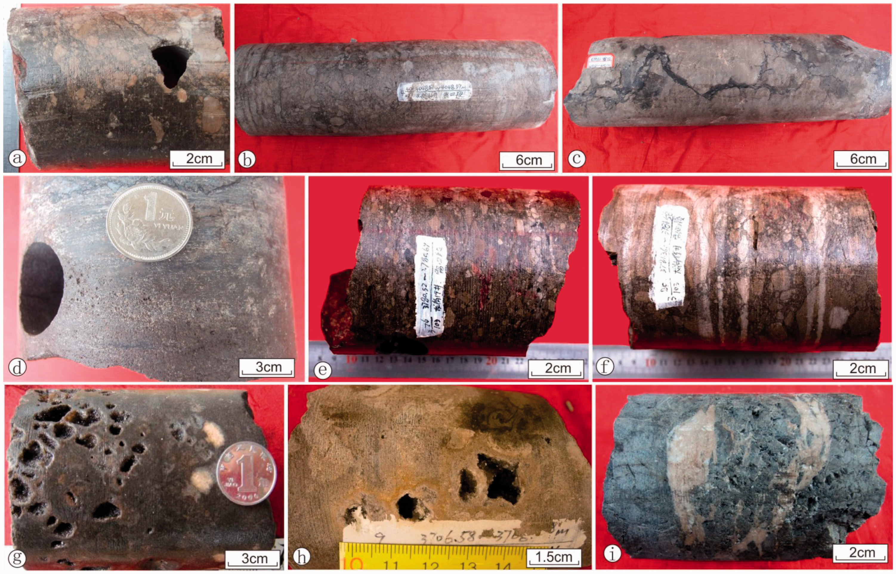
Karst transitional zone
A karst transitional zone refers to the inclined region between a karst highland and a basin where horizontal flow takes place due to the influence of the hydraulic gradient, triggered by vertical infiltration. The high flow velocity and the strong hydrodynamic intensity lead to an abundance of horizontal undercurrent karst zones, including large-scale underground rivers, dissolution karrens, and cave systems (Figure 8(a), (d) to (f)). As the karst fluid in a transitional zone is readily discharged, large amounts of dissolved material do not accumulate, resulting in many well-preserved karst caves. The continuous changes in the phreatic water table contribute to the development of multiple karst cycles as well as the superimposition of vertical vadose zones and horizontal phreatic zones, and this means that the most intense erosion is developed in the transitional zone. In addition, the long-term non-selective denudation of the karst water system results in alternations of monadnocks and karren within the transitional zone. In general, the Leikoupo Formation is better preserved in the monadnocks than in the karren, and the strong karstification effects and cyclic features are favorable for reservoir development.
Karst basin
A karst basin is the main catchment and drainage area and is characterized by low topographic elevation and minor geomorphological variation. Water flow is mainly in the form of surface runoff, which means a karst basin is characterized by weak hydrodynamics. Although the Leikoupo Formation is well preserved in the karst basin of the study area, dissolution pores are poorly developed and filled. The overlying Xujiahe Formation fills the lower areas on the underlying unconformity surface, and the huge thickness of mudstone enables the Xujiahe Formation to act as both seal rock and source rock for the underlying Leikoupo Formation (Huang, 2014; Wu et al., 2017).
Discussion
Relationship between karst and the hydrological environment
The effect of weathering is to produce widespread formation dissolution, which gradually evolves into dissolution pores, caves, and fractures. Differences in geomorphology lead to variations in the intensity of dissolution, and this is reflected in distinct degrees of development of pores, caves, and fractures, and in the diverse horizontal development and distribution of weathered-crust reservoirs.
Under the influence of Indosinian tectonism, seawater gradually retreated during the deposition of the Leikoupo Formation. At that time, the Longgang area was in a restricted environment surrounded by the Longmenshan, Kaijiang, and Luzhou paleohighs, and shoal development was extensive. Although the granular rocks underwent early compaction, dissolution, and cementation, the large amount of residual intergranular porosity provided a good foundation for karst development at a later stage (Li et al., 2011; Ma et al., 2012; Xin et al., 2013; Xu et al., 2013).
The huge uplift caused by Late Triassic Indosinian tectonism led to the long-term exposure (∼5 Myr) of the carbonate successions in the northeast Sichuan Basin (Ma et al., 2012), which made the formation vulnerable to weathering and denudation. The strata of the Lei43 submember were eroded strongly and are even locally absent. Monadnocks and karren coexist in the karst transitional zone (Figure 9).
Schematic diagram showing the types of karst geomorphological unit and the hydrogeological conditions.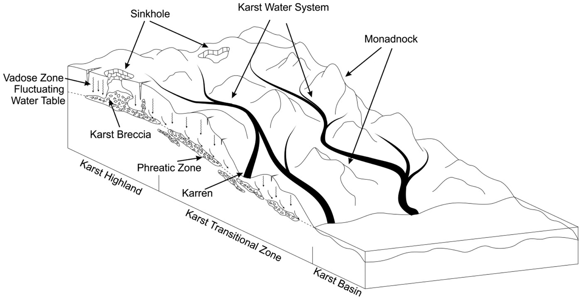
The long-term erosion and down-cutting by the karst water system meant that the preserved thickness of weathered-crust in the karren is smaller than in the monadnocks, and the most favorable reservoir strata were eroded. Moreover, the local catchment areas of the karren received large amounts of sedimentary infilling, and secondary sediments were generated, all of which led to reduced reservoir capacity. In contrast, the monadnocks are geomorphologically higher, and they underwent more intense and longer periods of karstification due to their positions above the water table. Moreover, the rapid infiltration of fluids in the monadnocks and the discharge of these fluids into the adjacent karrens meant that the dissolution pores in the monadnocks were preserved (Figure 8(d), (g) to (i)). At the same time, frequent changes in the position of the phreatic water table in the karst transitional zone resulted in the superimposition of multiple karst systems, thus producing the most intense and widespread karstification. Therefore, the karst transitional zone is the most favorable for the development of high-quality reservoirs.
The bottom of the dissolution zone in the karst highlands is generally higher than the water table, and the main reservoir interval is therefore prone to strong erosion and denudation, becoming thin or even locally absent. Moreover, the vertical vadose zone is dominant in the karst highlands, and the untimely discharge of fluids led to filling of the pores and reduced reservoir capacity. There are only a few good reservoirs in the area where grainstones are developed. In general, therefore, the karst highlands are not favorable locations for reservoir development.
A karst basin is the most important catchment area, and it features slow groundwater flows, undeveloped vadose zones, and strong sedimentary infilling and deposition. The strata within a basin are strongly influenced by karst pore-filling, and thus a karst basin is not a favorable location for reservoir development.
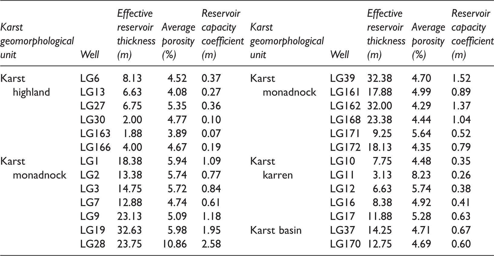
Relationships between the karst geomorphological units and reservoir capacity
Physical properties and reservoir capacities obtained from wells in the Lei43 submember of the Longgang area.
Conclusions
After making comparisons of different karst paleogeomorphological reconstruction methods, we adopted the karst thickness method to reconstruct the paleogeomorphology of the karst on top of the Leikoupo Formation in the Longgang area, taking into account the filling and sedimentary characteristics of the Leikoupo and Xujiahe formations. The method allowed us to finely characterize the karst paleogeomorphology in three-dimensional seismic sections. The reservoir rocks of the Leikoupo Formation were influenced mainly by the presence of shoals and the superimposition of karstification. Karstification of the weathered-crust was critical for the formation of high-quality reservoirs in the study area. The degree of development and distribution of the karst water system determined the karstification types and the ranges of action, which further controlled the reservoir capacities. The karst paleogeomorphology on the top of the Leikoupo Formation in the Longgang area can be described in terms of three types of unit: karst highlands, karst transitional zone, and karst basin. Monadnocks in the transitional zone have the highest quality reservoirs and are the most favorable areas for natural gas exploration. Reservoirs in the karst highlands and in karren are thin and have limited capacity due to strong denudation. The karst basin experienced weak karstification and has poorly developed reservoirs.
Footnotes
Acknowledgements
Professor Jingshan Chen is thanked for reviewing an earlier version of the manuscript.
Declaration of conflicting interests
The author(s) declared no potential conflicts of interest with respect to the research, authorship, and/or publication of this article.
Funding
The author(s) disclosed receipt of the following financial support for the research, authorship, and/or publication of this article: This study was supported by the National Natural Science Foundation of China (Grant No. 41602166).