
Abstract
Jurassic to Cretaceous clastic rocks of the South Turgay Basin were deposited in the typical Mesozoic rift basin formed during the late Triassic collision between the Kazakstan and Siberia plates. In this study, we used more than 140 wells and 2400 km2 of 3D seismic data in the northern Aryskum Depression to produce a detailed sequence stratigraphic interpretation of the South Turgay Basin. Guided by sequence stratigraphy, sedimentology, and structural geology, lower Jurassic-lower Cretaceous strata of the northern Aryskum Depression in the South Turgay Basin, Kazakhstan were subdivided into 10 third-order sequences based on geological and geophysical data. Combined with tectonic evolution characteristics, sequence developments in the basin can be divided into four stages: early rift stage (SQ1–SQ3), late rift stage (SQ4–SQ6), fault to depression transition stage (SQ7–SQ8), and depression stage (SQ9–SQ10). Through comprehensive analysis of seismic sequence configuration, sequence stacking pattern, and depositional filling characteristics, we established the depositional model of the Aryskum Depression in the South Turgay Basin. It is indicated that there are differences in depositional compositions of sequences formed in different stages. Four stages can be clearly identified: filling stage of fan delta facies–lacustrine facies (Stage I) corresponding to the rapid filling in the early rift stage, filling stage of fan delta facies–lacustrine facies–normal delta facies (Stage II) corresponding to trichotomous characteristics of internal systems tracts in the late rift stage, filling stage of braided river delta facies–normal delta facies–lacustrine facies (Stage III) corresponding to the development of high-stand systems tracts in the fault to depression transition stage, and filling stage of fluvial facies–normal delta facies–lacustrine facies (Stage IV) corresponding to binary characteristics of internal systems tracts in the depression stage. Finally, optimization of favorable exploration strata and prospects in the Aryskum Depression are proposed.
Keywords
Introduction
Located in the southern part of the South Turgay Basin, Aryskum Depression is rich in oil and gas resources. Structural traps have been found in the past 40 years, while stratigraphic–lithologic traps gradually became targets to enhance reserves and productivity (Kong et al., 2007; Kuandykov et al., 1993; Liu and Jiang, 2015; Otto, 1997; Ye et al., 2011). With ever-deepening exploration and research, the Aryskum Depression presents a good opportunity to explore subtle reservoirs. China National Petroleum Corporation has multiple exploration and development projects in the basin, covering most area of the Aryskum Depression. There have been about 140 wells, 855 2D seismic lines (a total of 18,757 km), and 13 blocks of 3D seismic projects (a total of 2435 km2). Data acquired in the early exploration stage laid a solid foundation for later works. Progress has been made in the Aryskum Depression (Mao et al., 2010; Sun et al., 2008; Yin et al., 2011; Zhou et al., 2008). Sun et al. (2008) divided the South Turgay Basin into three structural belts from west to east, namely western Akshabulak structural belt, middle Ashchysai anticline structural belt, and eastern Sarylan graben structural belt. Meanwhile, they proposed that the basin mainly experienced three tectonic evolution stages, rift stage (J2–J3), fault to depression transition stage (J3), and depression stage (K–N). Zhou et al. (2008) classified reservoir rocks into two classes according to the study on petrological characteristics, diagenesis and pore type evolution. In their opinion, Kumkol, Aryskum, and Akshabulak formations belong to Class I reservoirs, while Doschan and Aybolin formations belong to Class II reservoirs, both of which can be regarded as oil and gas targets. Mao et al. (2010) identified six fourth-order sequence boundaries by means of strata slice, phase conversion, and frequency decomposition processing and further put forward that the main environment of lower Jurassic-lower Cretaceous was fluvial delta facies. Yin et al. (2011) presented that stratigraphic–lithologic reservoirs in the Aryskum Depression should be mainly found in Jurassic strata by evaluating source-reservoir-cap assemblages, and there are three types of lithologic reservoirs: sandstone up-dip pinching-out reservoirs at the front of slope zone, isolated sandstone reservoirs in underwater distributary channels, and isolated sandstone reservoirs at the mouth bar. However, due to the complexity and diversity of continental basins as well as the large exploration area of Aryskum Depression in the South Turgay Basin with complex data, there is no consensus on sequence stratigraphic relationships and sequence boundary designations, which hinders the understanding of sequence developments characteristics and depositional filling models and therefore limits the optimization of favorable exploration targets in the Aryskum Depression.
In this article, the third-order sequence stratigraphic framework of the South Turgay Basin is established based on analysis of characteristics of seismic reflection termination and sequence stratigraphy boundaries in drilling. Moreover, sequence development characteristics in different stages are analyzed by integrating the seismic sequence configuration and sequence stacking pattern of the basin with drilling, logging, and seismic data. Eventually, horizontal and vertical characteristics of depositional filling evolution are summarized based on the correlation of well-tie sequence and sedimentary facies, and thus a depositional model of the Aryskum Depression is established to conduct systematic sequence stratigraphy and sedimentary facie studies so as to provide guidance for the prediction of favorable exploration areas.
Geological setting
The Turgay Basin is located in the middle part of Kazakhstan, with a total area of 20 × 104 km2. It can be divided into two parts, North Turgay Basin and South Turgay Basin. North Turgay Basin consists of three northeast to southwest grabens, namely Kustanay, Kushmurun, and Diangshay grabens (Alexeiev et al., 2009; Wilde et al., 2001; Yin et al., 2012). As the main body of Turgay Basin, South Turgay Basin is an intracontinental Mesozoic rift basin located on the shear zone of Ural-Tianshan suture with a total area of 8 × 10⁴ km2. To the east of the South Turgay Basin is the Chu-Sarysu Basin, to the north is the North Turgay Basin, to the west is the Ural Suture, and to the south is the Syr Darya Basin. The Karatau fault is the most important strike-slip fault in the basin (Figure 1(a)). The sedimentary center and the discovered petroleum resources are mainly located in the southern depression, so the South Turgay Basin mentioned below is referred to as the southern Aryskum Depression (slash area). Located in the southern South Turgay Basin, the Aryskum Depression is rich in oil and gas resources and extends from north to south along the long axis of the graben, with a total area of 3 × 10⁴ km2 (Moseley and Tsimmer, 2000). Influenced by Yanshan and Himalayan Movements, three sets of NW-SE faults developed in the Aryskum Depression. They are large and stretch from the basement to the surface, controlling the graben-horst basin structure consisting of four grabens and three horsts.
Tectonic units and division of the South Turgay Basin.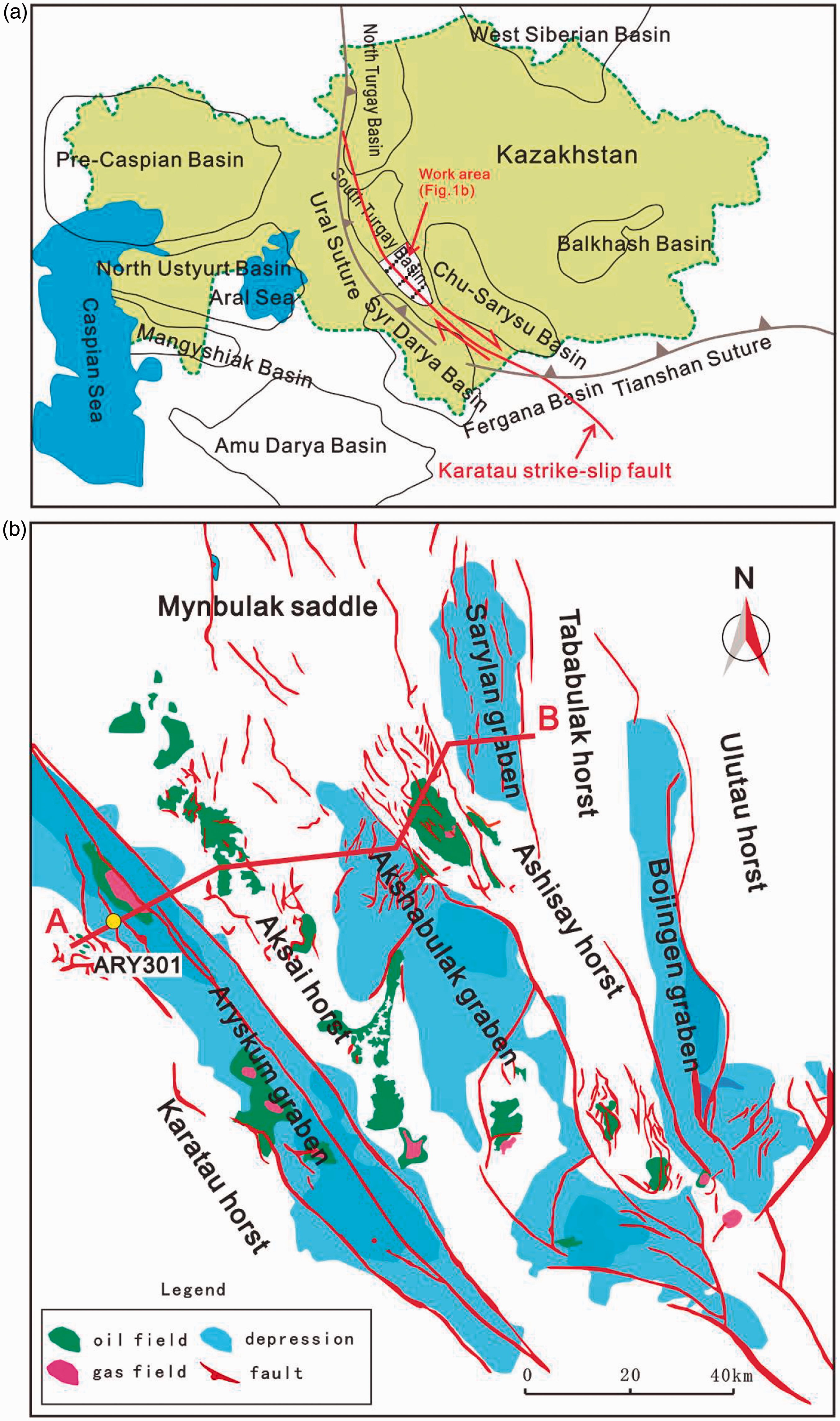
As shown in Figure 1(b), Aryskum, Akshabulak, Sarylan, and Bozigen grabens developed, which are separated by Aksay, Ashisay, and Tabakbula uplifts. These secondary structural units are distributed along the main fault extension, and can be divided into four groups of faults by their position, namely Aryskum, Akshabulak, Sarylan, and Bozigen fault zones (Allen et al., 2001). With the exception of the early Paleozoic metamorphic basements, the basin is mainly composed of continental clastic deposits, which can be divided into two structural layers. The lower structural layer consists of terrigenous clastic deposits in rifting stage from the late Triassic to the late Jurassic, in which there are three sedimentary cycles, namely late Triassic to early Jurassic, middle Jurassic, and late Jurassic. Each cycle is an up-fining cycle with the lithology varying from coarse to fine clastic rocks. Meanwhile, the upper structural layer is mainly the strata formed after the early Cretaceous, subjected to the uplift and erosion in a large region, and uncomfortably overlying on the lower layer (Ergaliev et al., 2008; Kirscher et al., 2013).
Sequence division from Jurassic to Cretaceous
Characteristics of sequence boundary in drilling wells
Channel erosional scour surface (SB2 and SB10)
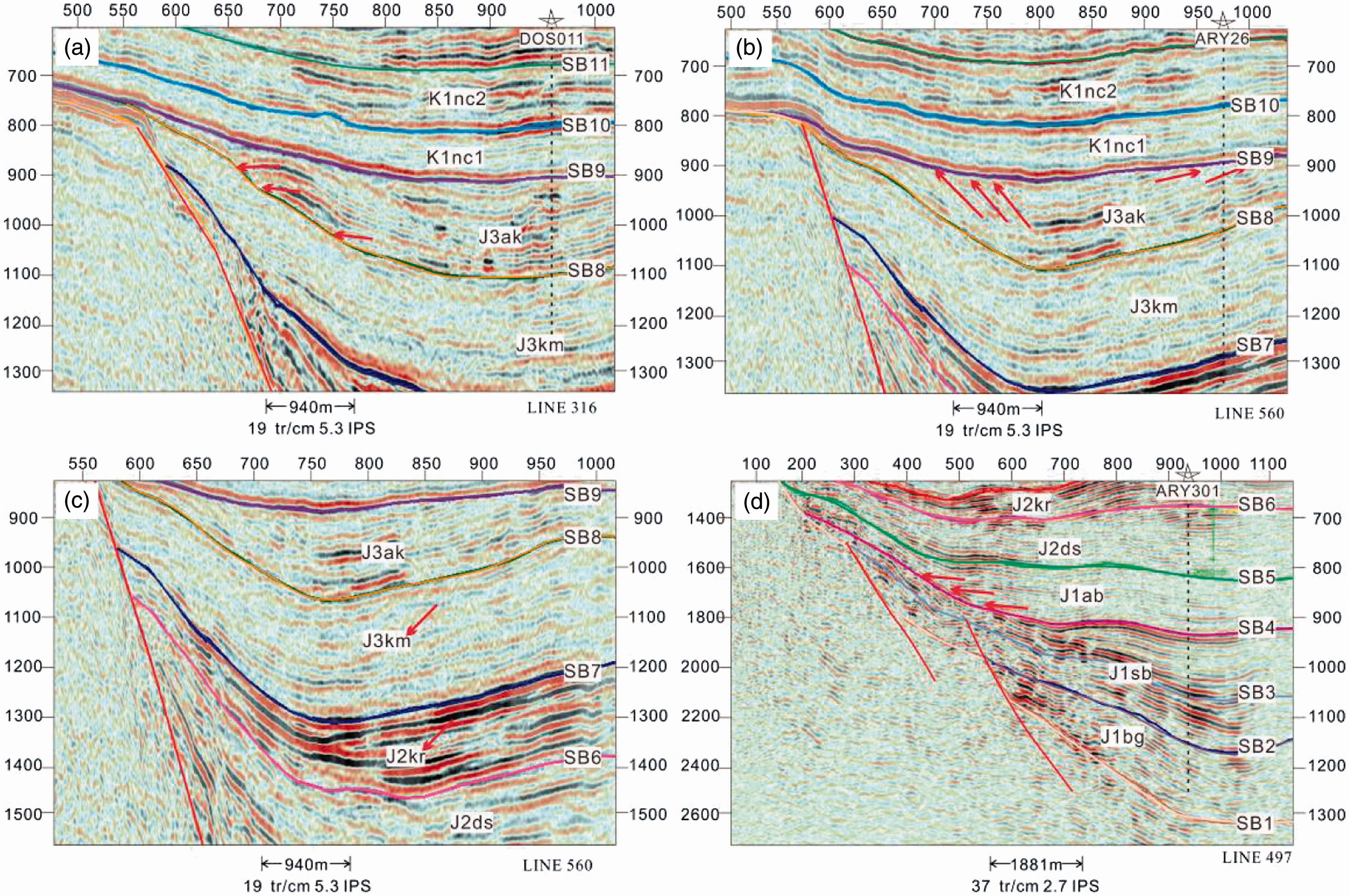
The boundary of the channel erosional scour surface generally represents the formation once exposed and eroded when there was no accommodation because the base level was below the earth surface (Huang et al., 2002; Wang et al., 2012). In this condition, the boundary suffered erosion and formed unconformity. SB2 and SB10 are typical channel erosional scour surfaces. SB2 is the boundary of the Bozhyngen and Sazymbai formation, with abrupt contact in curves of self-potential and resistivity logs. Above the boundary, there are coarse sediments which show strong amplitude and medium continuity in seismic data (Figure 3(d)) such as channel lag deposits or coarse to medium channel sandstones, while beneath the boundary there are mudstones showing weak amplitude and variable continuity on the seismic profile which develop in shallow lacustrine (Figure 2(b)). SB10 is the boundary of Down Dauls and Up Dauls formation, with bottom box-shaped abrupt contact in curves of self-potential and resistivity logs. What's more, areas of Well DOS011 shows the strongly continuous seismic events effects on the seismic profile corresponding to the channel erosional scour surface (Figure 3(a)). Large sets of glutenites or sandstones directly overlie the mudstone (Figure 2(j)), reflecting the sudden shoaling water body.
Characteristics of sequence boundaries in drilling wells of the South Turgay Basin. (a) Well UAR-6 top interface of basement metamorphic rocks; (b) Well ARY-301 channel erosional scour surface; (c) Well ARY-301 top interface of coal bearing strata; (d) Well DOS011 lithological and electrical transformation surface; (e) Well BOZ-1 top interface of coal bearing strata; (f) Well NN6 change of stacking patterns parasequence sets; (g) Well ARY026 lithological and electrical transformation surface; (h) Well BOZ-6 lithological and electrical transformation surface; (i) Well WK-3 change of stacking patterns parasequence sets; (j) Well DOS011 channel erosional scour surface. Characteristics of seismic sequence boundaries in the South Turgay Basin. (a) Onlap boundary(SB8 LINE 316); (b) truncation boundary(SB9 LINE560); (c) differences of seismic reflection characteristics(SB7 LINE560); (d) onlap boundary(SB4 LINE497).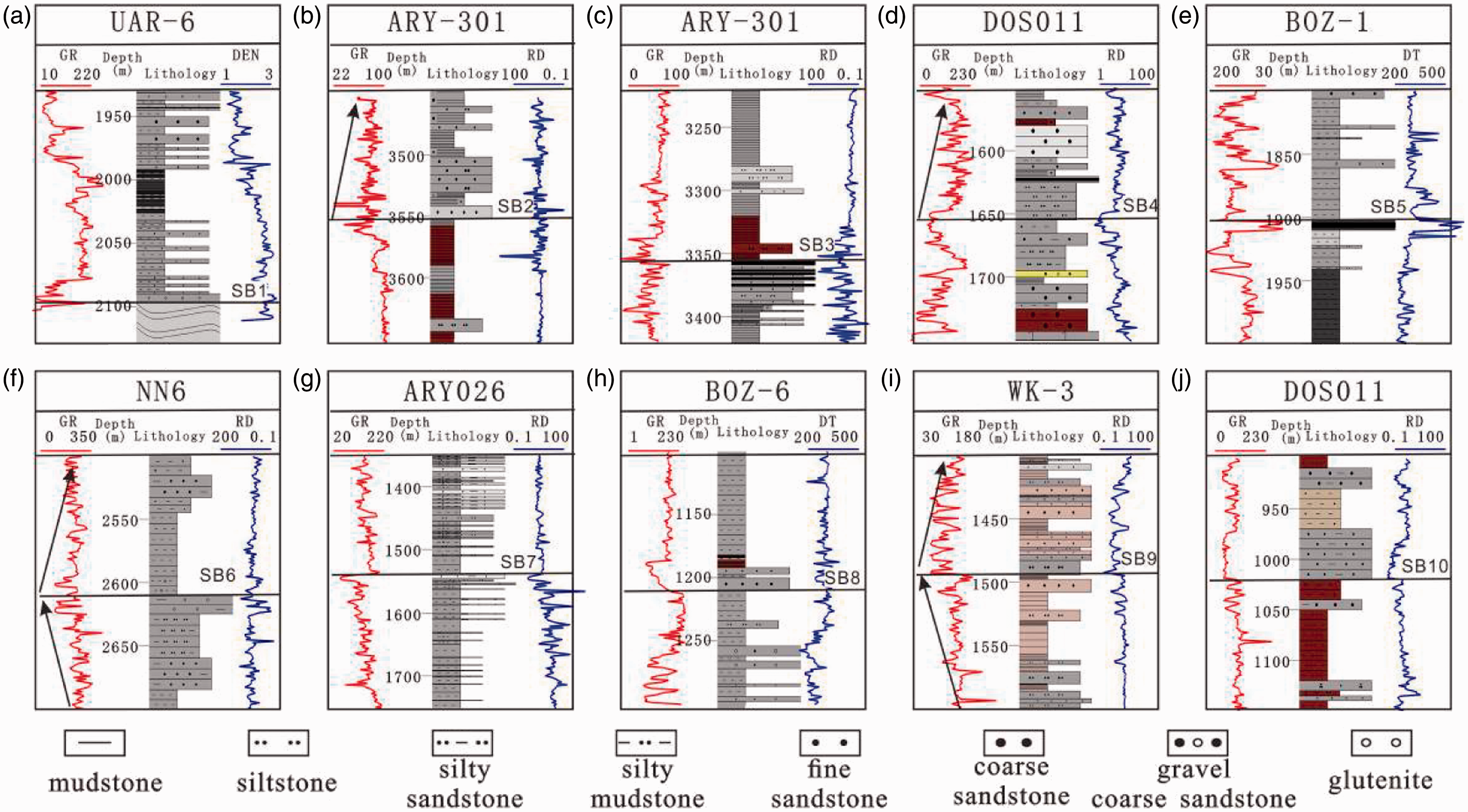
Lithological and electrical transformation surface (SB4, SB7, and SB8)
Well logging curves change abruptly due to the change of the sedimentary environment. SB4 is the boundary of Sazymbai and Aybolin formation. As shown in Well DOS011, channel sandstones that represent the branch channel deposits in delta front, composed of bell-shaped curves above the boundary developed. Meanwhile, under the boundary, mouth bar deposits in delta front with funnel–shaped logging curves developed (Figure 2(d)). SB7 is the boundary of the Karagansky and the Kumkol formation. As shown in Well ARY026, thick sandstones with few mudstone above the boundary which show chaotic to subparallel seismic reflection patterns on seismic profiles, reflecting strong energy sedimentary environment developed in the Kumkol formation. Meanwhile, under the boundary, sand and shale interbedded with mudstone which shows continuous and parallel seismic reflection patterns, reflecting weak energy in a shallow lacustrine sedimentary environment developed (Figure 2(g)). SB8 is the boundary of the Kumkol and Akshabulak formations. As shown in Well BOZ-6, mouth bar deposits in delta front with reverse graded bedding curves developed. Meanwhile, under the boundary, sandstones inter bedded with shale, representing branch channel deposits in delta front developed (Figure 2(h)).
Top boundary of coal bearing strata (SB3 and SB5)
In general, coal bearing strata form in a swamp environment (Chu et al., 2015). Widely distributed coal bearing strata can be a good sequence boundary with comparability and isochronism since they generally represent the end of a depositional event (Wang et al., 2011). SB3 is the internal onlap boundary in Sazymbai formation, while SB5 is the boundary of the Aybolin and Doschan formations. As shown in Well Ary301 and BOZ-1, the top boundary of coal bearing strata is regarded as the sequence boundary (Figure 2(c) and (e)).
Change of stacking patterns of parasequence sets (SB6 and SB9)
The ratio of accommodation and sediment supply (A/S) are the primary factors controlling regression and transgression in the geological record. When the ratio is A/S<1, new parasequences move toward the basin in turn and form progradation parasequence sets with lake regression; When the ratio A/S>1, new parasequences move toward the continent and form retrogradation parasequence sets with lake transgression; When the ratio A/S≈1, the parasequences don't move obviously in the lateral direction and form aggradation parasequences (Ainsworth et al., 2008; Blum and Roberts, 2009). Different stacking patterns can be identified in well logging curves, and their changes can reflect changes of water level and depositional cycles. Therefore, they could be used to indicate sequence boundaries. SB6 is the boundary of the Doschan and Karagansky formations. As shown in Well NN6, retrogradation parasequence sets developed above the boundary, reflecting the ratio A/S>1 and the gradually deepening water. But under the boundary, the curve shows progradation parasequence sets which reflect the ratio A/S<1 and the ample supply of sediments (Figure 2(f)). SB9 is the boundary of the Akshabulak and Dauls formations. As shown in Well WK-3, parasequence sets transform from progradation to retrogradation when in a vertical position (Figure 2(i)).
Top boundary of basement metamorphic rocks (SB1)
SB1 is the bottom boundary of Bozhyngen formation. As shown in Well UAR-6, the top boundary of metamorphic rocks is the sequence boundary (Figure 2(a)).
Characteristics of seismic sequence boundaries
Truncation boundary
A sequence boundary is commonly marked by significant erosional truncation beneath and onlap above (Williams, 1993). In some cases, seismic events are terminated in the boundary below with a large angle owing to structural uplift and erosion. Seismic reflection configuration changes on the boundary. Above the boundary is medium amplitude and medium continuity; while below there is erosional truncation (Figure 3(b)).
Onlap boundary
Onlap boundary refers to the boundary that a set of horizontal or slightly oblique seismic events intersect on in turn with similar angles (Figure 3(a) and (d)). If seismic events corresponding to onlap points are parallel to each other, they can be called parallel onlap. Meanwhile, if distances between seismic events become wider toward the basin direction, they can be called divergent onlap (Cartwright, 1991; Zhang et al., 2015). Onlap occurs in the condition that water body constantly enlarges. As it can be seen, the delta deposits of the Kumkol formation slightly onlap at the top of the Karagansky formation.
Differences of seismic reflection characteristics
Dual function of tectonic and sedimentary might lead to different occurrences of adjacent formation, reflecting in differences of seismic reflection characteristics on seismic profiles (Mooney and Brocher, 1987; Gilli et al., 2001; Wang, 2015). For instance, Kumkol formation is of weak amplitude and continuity above the boundary while the Karagansky formation is of strong amplitude and continuity below the boundary (Figure 3(c)). It is also shown in the drilling Well ARY026 which reflects different depositional environment.
Based on the large data set of logs, cores and seismic data in the research area and the comprehension of geological background, basin structure, and tectonic evolution history, lower Jurassic-lower Cretaceous of the South Turgay Basin is divided into 11 boundary surfaces and 10 third-order sequences, among which there are 2 first-order sequences (SB1 and SB9) as unconformity planes, 1 second-order sequence (SB7) as an uniformity plane and 7 third-order sequences (SB2, SB3, SB4, SB5, SB6, SB8, and SB10) as unconformity planes. Thus, the sequence stratigraphic framework of the South Turgay Basin (Figure 4) is established by using principles and methods of seismic stratigraphy and sequence stratigraphy.
Sequence division and characteristics of Jurassic to Cretaceous in the South Turgay Basin.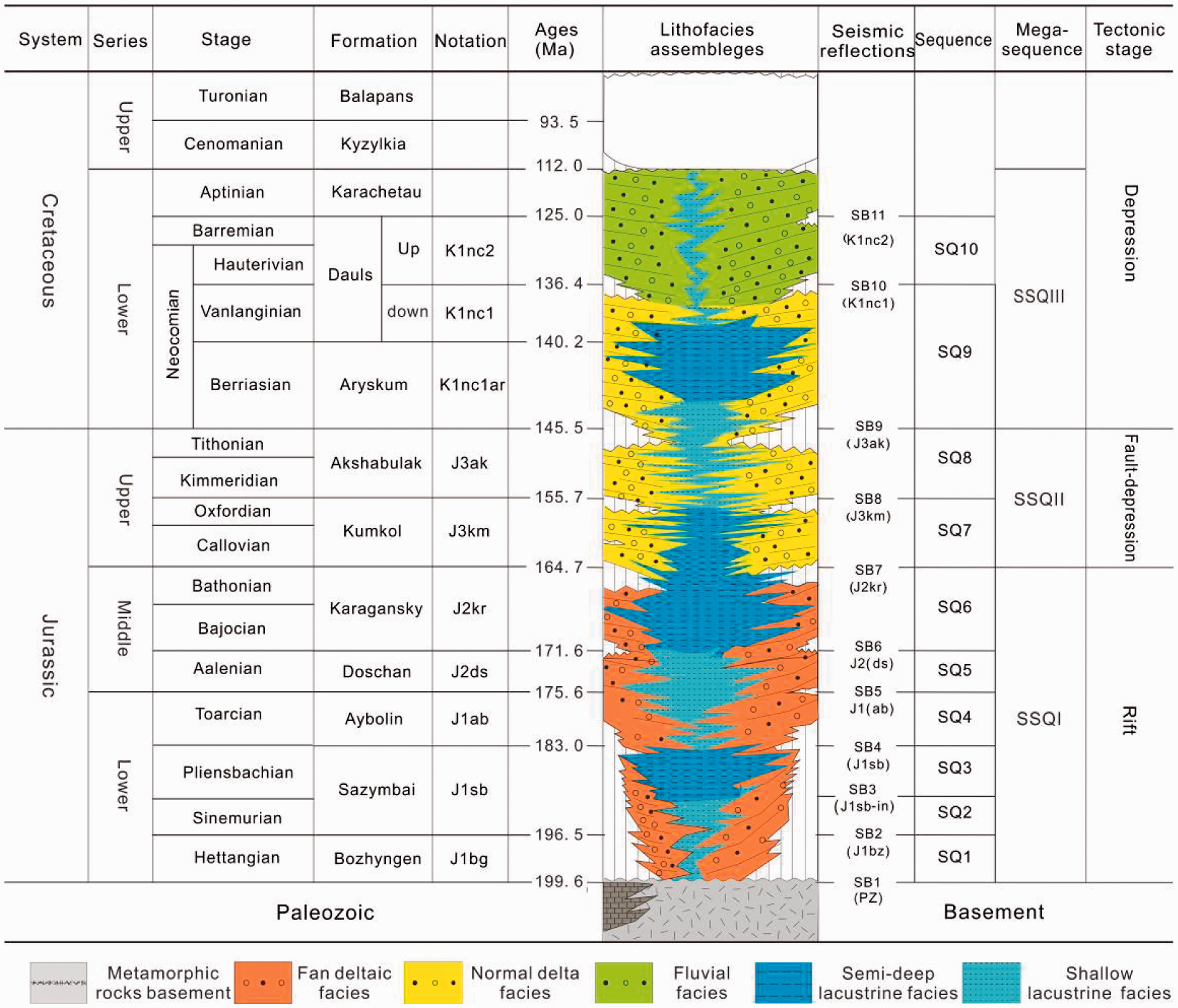
Sequence development characteristics and evolution
South Turgay Basin is a typical Mesozoic rift basin, with tectonic evolution experiencing rapid rifting stage in J1–J2, fault to depression transition stage in J3, and depression stage in K1. Tectonism has a dominant controlling effect on sequence filling of the basin. Specific type and distribution of depositional sequence exists in different stages, especially the early fault activity at the edge of the graben, which has an intense control on the development and distribution of the sequences (Goodbred and Kuehl, 2000; Wang et al., 2015). The sequence thickness has a significant discrepancy in the Jurassic period, later the unified basin pattern formed, and variation in sequence thickness retarded till the stage of Early Cretaceous depression. On the basis of comparative interpretation of through-well seismic profile, and combined with the structural features of the basin in different tectonic evolution stages, seismic sequence configuration, sequence stacking pattern, and sequence development characteristics in different stages are analyzed as follows.
Early rift stage (depositional stage of SQ1–SQ3)
Under the stretching stress in the approximately east-west direction, boundary faults of each graben in the basin formed rapidly and developed continually. At this moment, intense fault activities of the basin showed an obvious structural framework of depression alternating with uplift, and each graben was virtually independent (Chen et al., 2012). Steep and gentle slopes were both subjected to denudation. Sediment mainly came from provenance in the short axis of steep and gentle slopes in each graben, while provenance in the long axis had a feeblish sedimentary system (Kong et al., 2007). By this time, morphology of the basin was small and steep, mainly grabens with double faults such as Aryskum, Akshabluk, and Sarylan grabens. These three formations (SQ1–SQ3) record the initial rifting stage, while seismic facies show medium amplitude, low continuity and chaotic to subparallel seismic reflection configuration, and therefore, systems tracts cannot be easily subdivided (Figure 5).
(a) Seismic interpretation section in study area (upper); (b) seismic reflection characteristics in study area (down). (The section position referred to Figure 1.)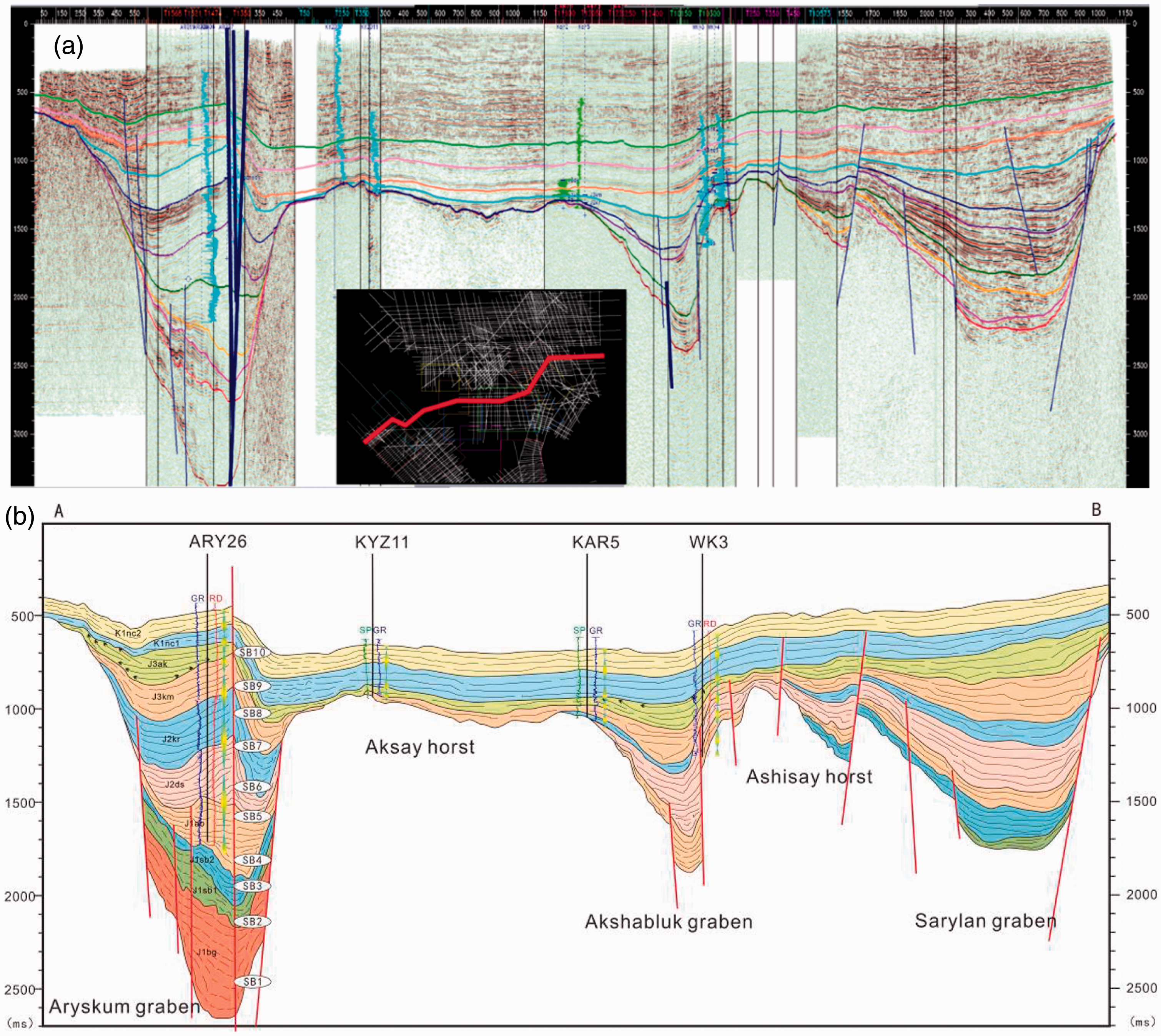
Only developing in Aryskum graben, the first sequence (SQ1) roughly corresponds to Bozhyngen formation in the lower Jurassic, and its lower formation is a basement with the unconformity Paleozoic on the top. This sequence is mainly a rising semi-cycle of base level with large sequence thickness. Well Ary301 is close to the strike-slip fault in the northwest of Aryskum graben, seen from logging of this well (Figure 6), the rising semi-cycle of base level of the SQ1 mainly has the lithology of coarse and fine sandstone interbedded with a small amount of mudstone and occasional coal. SP and GR indicate the retrogradation of bell shape, developing low-stand systems tract (LST) and reflecting sedimentary characteristics of a fan delta plain. Meanwhile, the falling semi-cycle of the base level is aubergine mudstone, showing more shallow sedimentary characteristics of a fan delta plain. The second sequence (SQ2) is approximately in line with the lower Sazymbai formation in the lower Jurassic. However, the third sequence (SQ3) is roughly commensurate with the upper Sazymbai formation in the lower Jurassic, of which the bottom boundary is an onlap unconformity plane in internal strata of Sazymbai formation. SQ2–SQ3 develops in both Aryskum and Sarylan graben, with the characteristics of medium reflection amplitude and quite strong continuity (Figure 5). Well drilling shows SQ2 has SP, GR, and RD curves in serrated shape, while the SQ3 has straight morphology of electrical logging (SP, GR, and RD), with high-anomaly of SP and low-anomaly of RD (Figure 6). Inside of the SQ3 there are mainly stable mudstone and shale, interbedded with flagstone and siltstone. Maximum flooding surface of SQ3 corresponds to the first lake transgression on a relatively large scale in the basin.
Lithology and well log data for Well ARY301 to show the sedimentary facies, sequence cycle, and systems tracts characteristics (position is marked in Figure 1).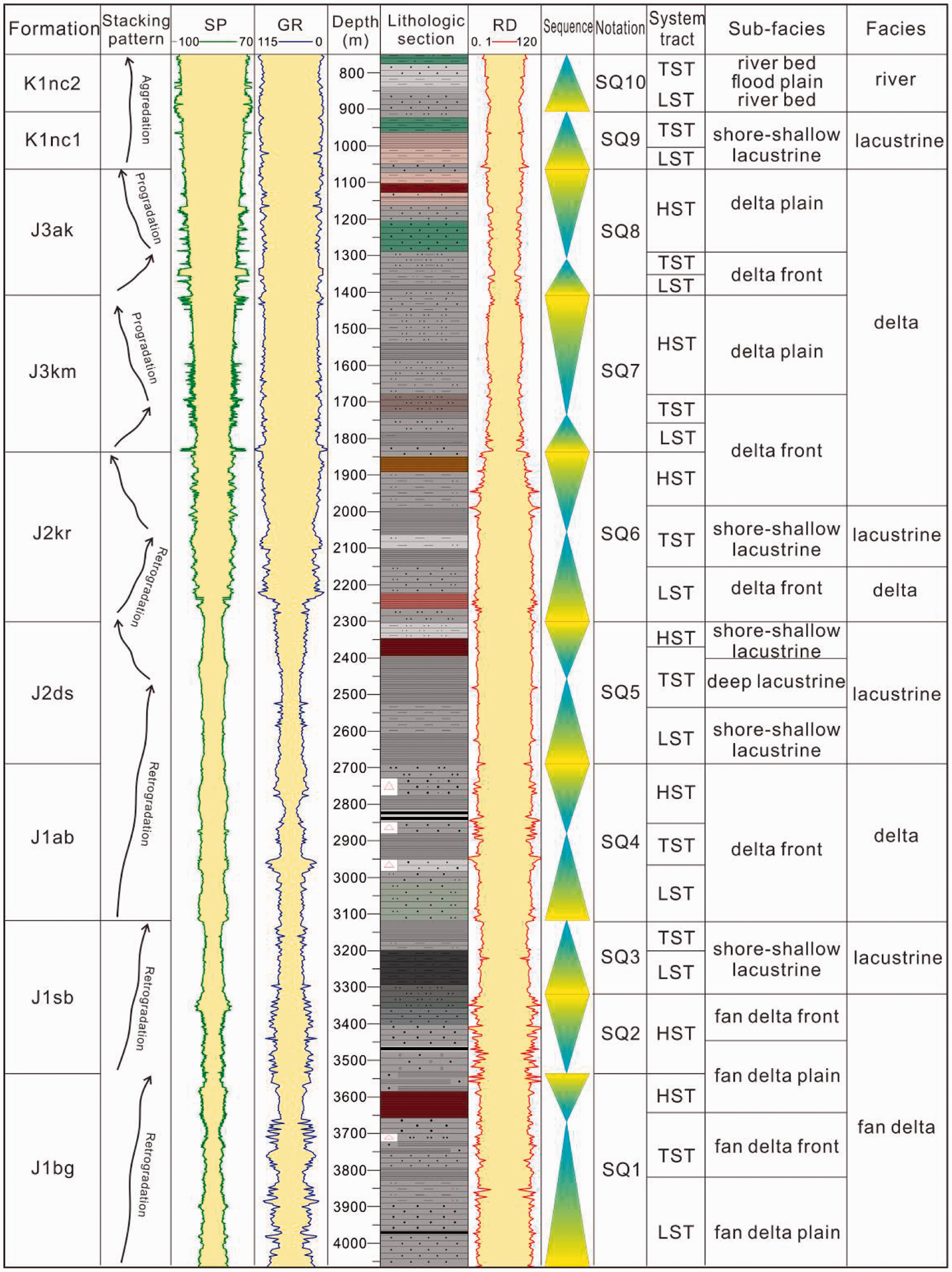
It is now widely agreed that the accommodation space is depends on the accumulated subsidence and sediment supply in the basin. Moreover, the accumulated subsidence is affected by tectonism, climate, and lake level change. In this stage, regional tectonic events and sediment supply are the main factors to control the accommodation space. Sediment supply rates could not keep up with displacement on intense tectonic movements and the accommodation space increases (Figure 7). The whole Aryskum Depression inherits the sedimentary pattern of SQ1. And during the development stage of SQ2 and SQ3, rift aggravated gradually resulting in the increase of accommodation. Then adequate supplement of sediments, fast change of lithology, and intense tectonic movements result in chaotic and multiform stacking patterns of sequence. LST and transgressive systems tract (TST) in SQ2–SQ3 can be recognized and classified as drilling wells, but the boundary of the whole systems tracts is hard to differentiate due to the deep buried depth, sharply enhanced accommodation, and the rapid filling of the sequence (Figure 7).
Seismic sequence configuration and sequence stacking patterns sequence of different stages in the South Turgay Basin.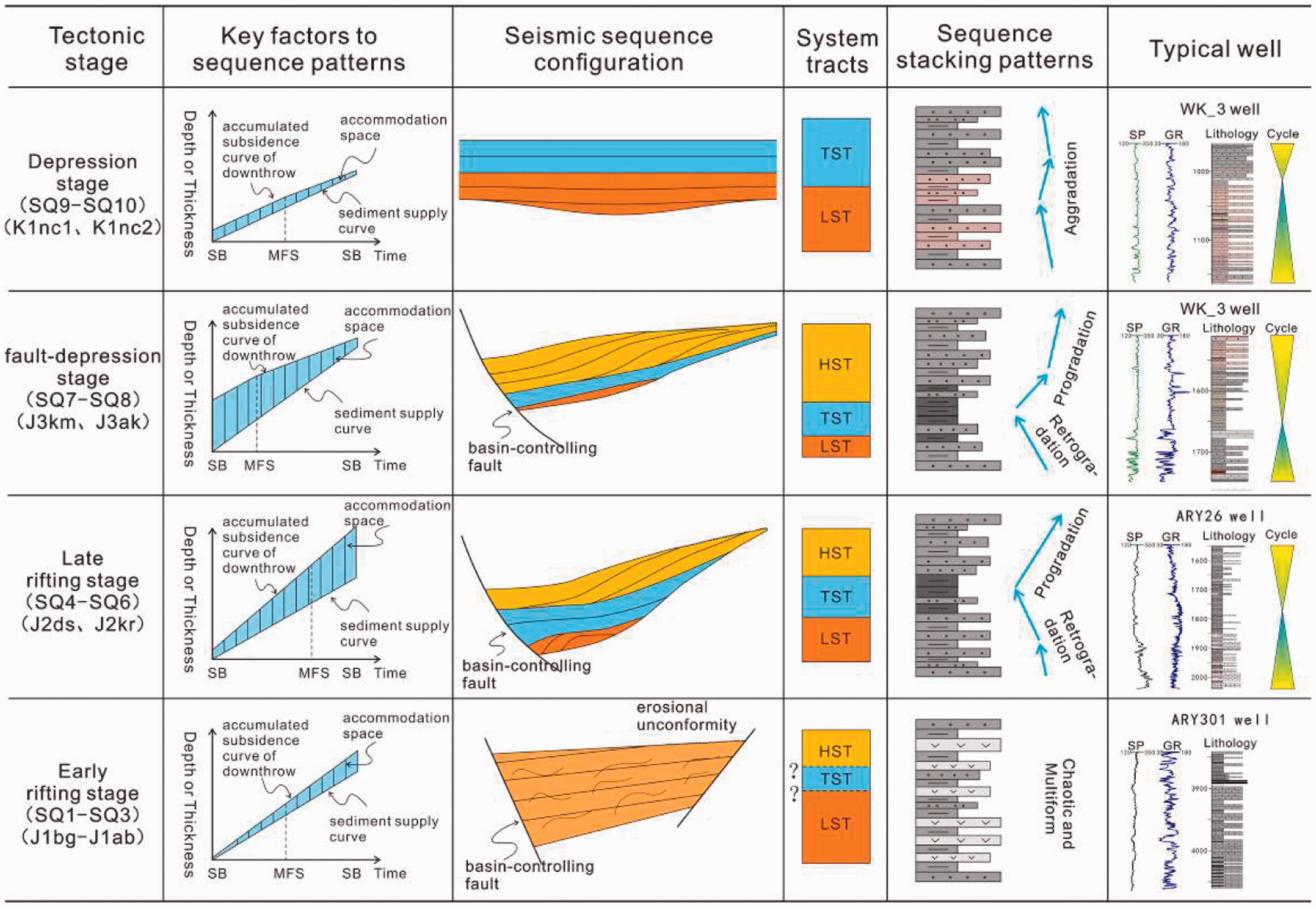
Late rift stage (depositional stage of SQ4–SQ6)
During this stage, the basin configuration was mainly a half graben with a single fault. Growth fault was in the east of Akshabluk and Sarylan grabens with high and steep slopes, while in the west there was a gentle slope with few faults, showing coexistence of sedimentary slopes and faults. Seismic facies during this period can be divided into two sets corresponding to the two stacking pattern transform sets in Figure 6. The lower facie contains medium continuity and slightly divergent seismic reflection configuration with low frequency. The upper seismic facie exhibits continuous, medium amplitude, and subparallel reflections. They both have three distinctive sections: one pronounced LST, one TST, and one high-stand systems tract (HST). The basin inherited the structural framework of depression alternating with uplift and each graben was independent. High elevation regions with preexisting steep slope zones and gentle slope belts still suffered denudation (Figure 5).
The fourth sequence (SQ4) corresponds to Aybolin formation in lower Jurassic, and develops in all three grabens, with subparallel seismic reflection of irregularity and poor continuity. In Well Ary301 (Figure 6), SQ4 has a thickness of 410 m, SP, GR, and RD curves show a superposition that is funnel-shaped and box-shaped. Its predominant lithology is silty mudstone and dark gray fine sandstone interbedded with middle-fine sandstone. SQ5 is commensurate with Docshan formation in the lower Jurassic with a thickness of 400 m in Well Ary301. Strata of Doschan formation has a wider distribution than that of Aybolin formation, with the fine lithology of mudstone interbedded with a few siltstone. SQ6 corresponds to the Upper Karagansky formation in Middle Jurassic, showing a thickness of 450 m in Well Ary301 and distributing more extensively than Aybolin formation and Doschan formation but not far away from the boundary of grabens (Figure 5). This formation has lineups in strong amplitude and continuity in the seismic reflection, with the lithology of silty mudstone and pure mudstone. In this period, the basin suffered the second large-scale lake flooding, and the mudstone formed during in the lake flooding period became source rocks of enormous distribution in the whole region.
In this stage, tectonism and sediment supply are the main factors influencing the amount of accommodation space and the sequence stacking patterns are dominated by a combination of retrogradation and progradation processes. The rate of sediment supply slowed down, and amplitude of variation in tectonic subsidence of the basin was constant that the accommodation space kept on increasing, which results in the sequence stacking patterns with a strong retrogradational component. Rising semi-cycle and falling semi-cycle of the base level are preserved relatively complete in the sedimentary record of the sequence, and they have trichotomous characteristics within internal systems tract (Figure 7).
Fault to depression transition stage (depositional stage of SQ7–SQ8)
The basin came into the fault to depression transition stage, in which deposition range surpassed the earlier grabens in limited distribution and the entire basin received deposits (Figure 5). There were two rounds of transient uplifting and folding which lead to two distinctive seismic reflection features. And in the terminal stage of SQ7, tectonic uplift resulted in partial denudation of strata and formation of unconformity between SQ7 and SQ8. While in SQ8 terminal stage, there were more uplifting strata and more extensive denudation due to tectonic movements, and there existed a universal phenomenon of reduction on the top of SQ8 at the edge of the basin.
SQ7 corresponds to the Kumkol formation in the lower part of upper Jurassic with a thickness of 400 m in Well Ary301 (Figure 6). Inside the strata, characteristics of seismic reflection can be obviously divided into two sets of combinations, the upper one and the lower one. The lower combination is a weak foreset reflection, while the upper combination is a continuous set of parallel strong reflection (Figure 5). In drilling wells, the rising semi-cycle of base level is mainly sandstone–mudstone alternating layers, with well logging curves (SP and GR) in the shape of serration. While the falling semi-cycle of base level is progradation reflection, with mudstone interbedded with thin sand layers as the main lithology. SQ8 is commensurate with Akshabulak formation in the upper part of Upper Jurassic, with a thickness of 350 m in Well Ary301. This sequence is absent only in the uplifted area, but fills and levels up in the depressed region, with the top suffering from regional denudation. It has an apparent smaller sedimentary thickness of rising semi-cycle than that of falling semi-cycle (Figure 6). There is also a negligible proportion of LST and TST, contradicting with the larger proportion of HST. Well logging curves (SP, GR, and RD) in box shape can be generally seen. As for lithology, the falling semi-cycle of base level is almost celadon sandstone, while the rising semi-cycle of base level is sandstone–mudstone alternating layers.
Topography in this stage was gentle, and sediment supply played a more important role in the increasing of accommodation space than tectonic subsidence. The rate of sediment supply didn't change much during this period. However, the amplitude of tectonic subsidence of the basin decreased in later stage, resulting in the reduction of the accommodation and causing the sequence stacking patterns with a more pronounced progradational component. Integrated rising and falling semi-cycles of base level are preserved well, with trichotomous characteristics of internal systems tract and development of HST (Figure 7).
Depression stage (depositional stage of SQ9–SQ10)
Entering the depression stage, the basin had a more extensive sedimentary distribution and less variation of lateral thickness. Gentle successive slopes dominated the basin and provenance varied as the transition from fault to depression (Figure 5).
SQ9 roughly corresponds to Aryskum formation and the lower Dauls formation in the lower Cretaceous and Jurassic with a thickness of 150 m in Well Ary301 (Figure 6). The bottom lithology is mostly coarse sandstone, with an upward transition to mudstone. HST doesn't develop. The third lake flooding period occurred in SQ9, depositing a set of stable mudstone in the entire region as cap rocks. SQ10 is approximately commensurate with the Upper Dauls formation in the lower Cretaceous and Jurassic, with a thickness of 120 m in Well Ary301 and curves of SP, GR, and RD in finger-shaped superposition. Lithology is sandstone and siltstone alternating with mudstone. Fluvial deposit develops, as well as the TST of sediment filling dominated by flood plain with high accommodation and the LST of channel filling with low accommodation, on the contrary to the poor development of the HST.
In this stage, the accommodation space is affected by the climate, lake level change, and sediment supply. There was continuous sediment supplied, but fault activities basically stopped. The amplitude of tectonic subsidence was smaller than the rate of sediment supply and the accommodation was basically balanced, giving rise to the only preservation of the rising semi-cycle of base level in the sequence and the deficiency or depositional hiatus of the falling semi-cycle which results in the sequence stacking patterns with a strong fluvial aggradation component. Merely, LST of channel deposits and TST of flood plain deposits developed, and HST was denuded or underdeveloped (Figure 7).
Evolution and depositional filling models
Based on the analysis of sedimentary facies and subfacies of 40 key wells in three grabens: Aryskum, Akshabulak, and Sarylan, and by comparing multiple profiles of connected wells, transmeridional connected well profiles with representativeness are selected for the comparison and analysis of the interwell sedimentary facies to uncover the depositional filling characteristics and the depositional evolution rules of Aryskum Depression in the South Turgay Basin. The cross section AB of dos1-ary301∼wk3-wk4∼sarylan1p (Figure 1) in the north of the South Turgay Basin spans three grabens, and reveals the development and evolutionary characteristics of the gentle slope belts and steep slope zones in each graben (Figure 8). Due to the early development of Aryskum graben, 10 stratigraphic sequences are complete only in Well Ary301. In order to better reflect the lateral distribution of the depositional filling, some strata not drilled in Well Ary26, Ary27, WK-4, 2277, and 2286 have been complemented according to corresponding layers on the seismic profile (Figure 5(a)). Akshabulak graben develops seven sequences SQ4–SQ10 and Sarylan graben develops nine sequences SQ2–SQ10. During the depositional filling and evolutionary process of these sequences, the depositional model is not only of certain succession, but also of mutability. As for Aryskum graben, the depositional model of Aryskum Depression in the South Turgay Basin is analyzed (Figure 9). Seen from the view of the depositional filling, evolutionary stages can be divided into the following four parts.
Cross section AB (Figure 1) of dos1-ary301 ∼sarylan1p wells showing depositional filling characteristics through the South Turgay Basin. Depositional model of Aryskum Depression in the South Turgay Basin.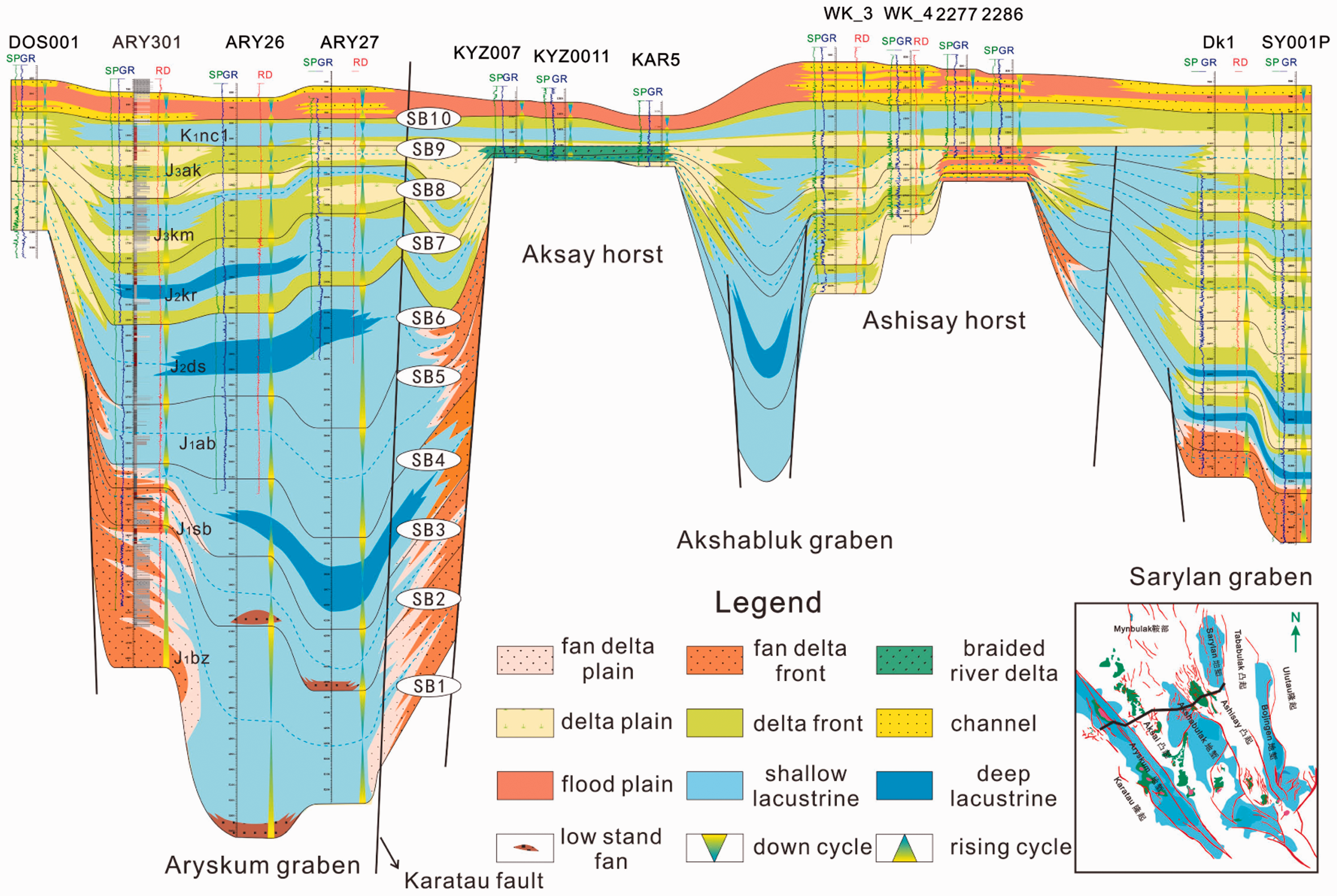
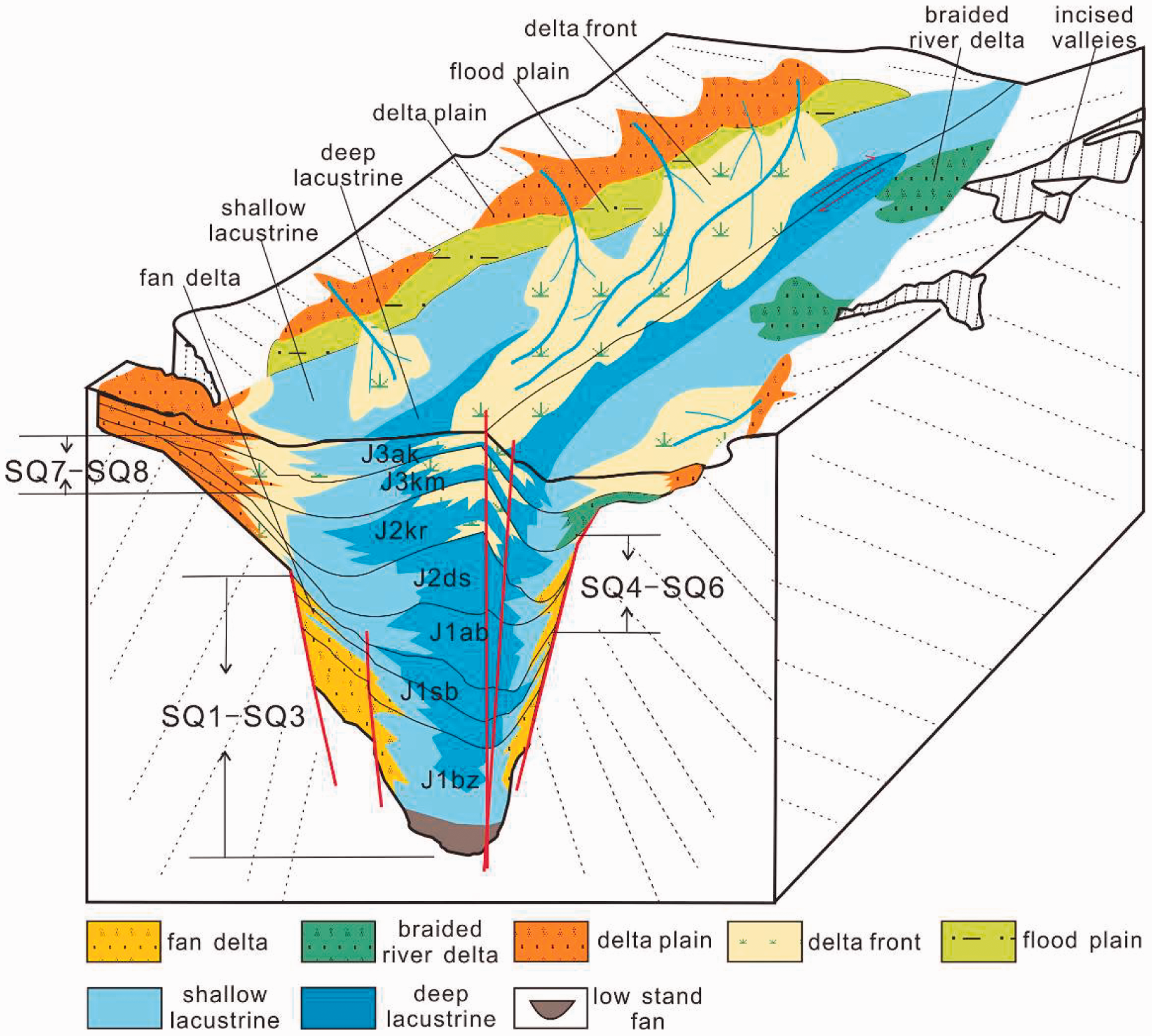
Filling stage of fan delta facies–lacustrine facies (Stage I)
During the sedimentation of early SQ1, the basin had less water but comparatively adequate provenance, developing fan delta deposits along the graben margin as well as low-stand fans in the direction toward semi-deep lacustrine. SQ2 developed multiple glutenite and sandstone, with fining upward sequence such as a few mudstone and coal seam interbedding. It mainly developed fan delta deposits along the faults. Sarylan graben developed during the sedimentation of SQ2, and mainly formed fan delta deposits in Wells DK1 and Sy001p (Figure 8). During the SQ3 period, the basin gradually extended, the lake deepened, and retrogradation of fan delta occurred in Well Ary301.
Analysis of well logging curves, cores and seismic data indicate that SQ1–SQ3 are mainly fan delta and lacustrine facies developed during the early extensional rifting of Aryskum graben, and then the depositional model of this stage can be established (Figure 9). In the early stage, there were strong characteristics of double faults, large accommodation and rapid filling of the clastic sediment, and there were fan delta deposits along the fault and low-stand fan in central areas of the lake basin, However, seismic and drill data does not show clear systems tracts. Until the SQ3 period, the maximum lake flooding surface of this sequence is commensurate with the first large-scale lake transgression in the basin. Then deep lacustrine in the sedimentation center of the basin began to develop, and the range of shore-shallow lacustrine and semi-deep lacustrine extended (Figure 9).
Filling stage of fan delta facies–lacustrine facies–normal delta facies (Stage II)
Since SQ4, the lake became shallow and Well ARY27 developed shore-shallow lacustrine deposits instead of deep-semi deep lacustrine deposits, which indicate both basin subsidence and attenuation of extension may be related to the reduction of tectonic subsidence rate. Since SQ4 deposited, Well ARY301 changed in a vertical direction from fan delta deposit to shore-shallow lacustrine deposit. This showed the decrease of sediment deposit velocity and the short supply of provenance. From SQ5 to SQ6, Well ARY26 and ARY27 were mainly deep-semi deep lacustrine deposits, and Well ARY301 also transformed into normal delta deposits from the early fan delta deposits, with the enlargement of depositional area, the reduction of fan delta, the increasing proportion of normal delta and the deepening of lacustrine water body (Figure 8). Besides Aryskum graben with the feature of double faults, Akshabulak and Sarylan grabens are both single faults, developing a more extensive range of normal delta facies in single fault zones.
Both seismic and drill data indicate that SQ4–SQ6 are filling stages of fan delta facies–lacustrine facies–fluvial delta facies (Figure 9). During the period, seismic and drill data indicate obvious divisions of three different systems tracts with a more apparent LST corresponding to a stronger retrogradational component. Till the SQ6 period, the depression experienced the second lake flooding period, forming shore shallow-semi deep lacustrine facies from shore-shallow lacustrine facies.
Filling stage of braided river delta facies–normal delta facies–lacustrine facies (Stage III)
Since the deposition of SQ7, the basin entered fault to depression transition stage and the lake area reduced. Wells DOS001, WK_3, and WK_4 show delta plain facies and Wells ARY301, ARY26, and ARY27 are mostly delta front facies. Meanwhile, Wells KYZ007, KYZX001, and KAR5 mainly present braided river delta deposits, which are located in the bulge region of the basin with thin sedimentary thickness, near provenance and coarse grain size of sediments (Figure 8).
Well logs, cores and seismic data indicate SQ7 and SQ8 are a set of braided river delta-normal delta deposits, with types of sedimentary facies like normal delta facies, braided river delta facies, lacustrine facies, and fluvial facies. During the fault-depression stage, the distribution of sedimentary system was less affected by the faults (Figure 9). Normal delta developed widely in this filling stage, while braided river delta partially deposited along the east steep slope zones due to the nearby provenance from the denudation area. Shore-shallow lacustrine deposit developed in the sedimentation center of the basin.
Filling stage of fluvial facies–normal delta facies–lacustrine facies (Stage IV)
Till the development of SQ9, the basin came into the depression sedimentation period, with delta front sedimentary facies in Well DOS001, shore-shallow lacustrine facies in Well ARY301, ARY26, and ARY27. Delta facies were mainly marginal facies and the whole basin was in shallow water. SQ10 broadly developed fluvial deposits, and the meandering river evolved from the braided river. It also developed channel filling deposits of low-stand Figure 8 and interchannel overbank deposits of TST. Generally, fault activities basically stopped in this stage, the amplitude of depression subsidence gradually reduced, and sedimentation in the whole basin was stable with the characteristics of braided river-meandering river-normal delta-lacustrine filling (Figure 8). Well logs and drill cores indicate SQ9 and SQ10 are a series of fluvial-normal delta deposits, developing normal delta and flood plain in the steep slope zone, braided river delta in the gentle slope zone and lacustrine facies in the center of the basin (Figure 9).
In conclusion, there is a certain regularity of depositional filling evolution in the process from SQ1 to SQ10 especially in the Aryskum graben. From the bottom up, filling deposits in fault basin transferred to the transition of fault and depression, and then gradually evolved into the depression stage. Similarly, the type of sedimentary facies evolved from fan delta–lacustrine facies in the early rift period into the filling stage of fan delta–normal delta–lacustrine facies in the late rift period, then braided river delta-normal delta-lacustrine filling stage till the late Jurassic. During Early Cretaceous, the basin entered a depression stage based on differential thermal subsidence, with a halt of fault activities, thus reducing amplitude of depression subsidence and wide development of stable fluvial facies deposits (Figure 9).
Oil-gas exploration prospect
According to the oil and gas distribution statistics in more than 140 wells in South Turgay Basin, it is clarified that oil wells refer to the wells producing oil or the wells whose water content is not 100%, gas wells refer to the wells exclusively producing gas, and water wells refer to the wells whose water contents are 100%. Pay beds, in theory, refer to the beds whose oil saturation is greater than the critical flowing saturation, while the beds with lower oil saturation than the critical flowing saturation exclusively produce water. Therefore, the oil saturation is not fully recorded, which significantly shrinks the actual oil-bearing area. However, the distribution of oil wells can to some degree reflect the formation and occurrence principles of oil and gas so as to provide references for further exploration.
Oil, gas, and water wells production statistics.
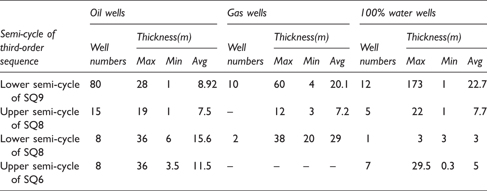
In general, the formation and occurrence of oil–gas reservoirs are commonly controlled by multiple geological factors, among which high quality seal rocks play a more critical role in the South Turgay Basin. The predominant source rocks are J1ab, J2ds, and J2kr lacustrine mudstone, which are of type I and type II, high organic matter abundance, and high maturity, with the total organic carbon (TOC) reaching 1.0–1.5% and the vitrinite reflectance (Ro) reaching 0.75–1.02% (Yin et al., 2012). The main targeted exploration layers are upper Jurassic and lower Cretaceous channel and delta sand bodies which were formed in the low systems tract. Currently, anticline reservoirs in the ancient uplifts are explored while more attention shall be paid to the lithological reservoirs in the slope area in the next step, of which the thick and widely distributed mudstone deposited during the sedimentary period of SQ3, SQ6, and SQ9 should be highlighted since they can be effective source rocks as well as high quality seal rocks, thus forming favorable source-reservoir-seal assemblages. Therefore, two types of sand bodies corresponding to locations around three flooding surfaces should be highlighted as favorable exploration target zones in the next step, namely those related to fan bodies interbedded within thick mudstone or near them during the sedimentary period of SQ3 and SQ6, and those related to delta front deposited during the sedimentary period of SQ9.
Conclusions
Based on the extensive collection of well drilling, logging, and seismic data in the research area and the comprehension of geological background, basin structure, and tectonic evolution history, as well as principles and methods of seismic stratigraphy and sequence stratigraphy, lower Jurassic-lower Cretaceous strata of the South Turgay Basin are divided into 11 boundary surfaces and 10 third-order sequences, among which there are 2 first-order sequences (SB1 and SB9) as unconformity planes, 1 second-order sequence (SB7) as an uniformity plane, and 7 third-order sequences (SB2, SB3, SB4, SB5, SB6, SB8, and SB10) as unconformity planes. Finally, the third-order sequence stratigraphic framework of the South Turgay Basin is established, and it is demonstrated that the whole basin experienced wide-range lake flooding three times. The flooding corresponding with SQ3, SQ6, and SQ9, which are favorable for oil and gas accumulations and thus should be the main exploration strata in the next round of exploration.
Lower Jurassic-lower Cretaceous depositional filling of the South Turgay Basin can fall into four stages: early rift stage (SQ1–SQ3), late rift stage (SQ4–SQ6), fault to depression transition stage (SQ7–SQ8), and depression stage (SQ9–SQ10). The early rift had characteristics of rapid sequence filling, comparatively chaotic seismic facies, systems tracts with hard division, and deposit filling of fan delta–lacustrine facies. The late depression had more accommodation, relative rapid filling of sequence, systems tracts with conspicuous trichotomous characterisitics, and deposit filling of fan delta–normal delta–lacustrine facies. During the transition from fault to depression, there was a smaller proportion of LST and TST but a larger proportion of HST, developing braided river delta–normal delta–lacustrine facies filling. In the depression stage, fluvial facies developed systems tracts in obvious binary feature and deposits filled were mainly fluvial–normal delta–lacustrine facies.
Footnotes
Acknowledgments
I want to express my sincere gratitude and appreciation to all those who helped me and gave me good advice during the writing of this article.
Declaration of conflicting interests
The author(s) declared no potential conflicts of interest with respect to the research, authorship, and/or publication of this article.
Funding
The author(s) disclosed receipt of the following financial support for the research, authorship, and/or publication of this article: This research was sponsored by the National Major Projects of Oil& Gas (No. 2016ZX05049001), the seismic data and well data are supported by the project “Evaluation of the Lithologic and Stratigraphic Trap in The Slope of Aryskum in the South Turgay Basin, Kazakhstan” (No. CNPCIRC-B_2013-xx).