
Abstract
Urban heat island (UHI), one of the critical consequences of climate change, represent a significant environmental challenge arising from physical interventions during urbanisation. Unplanned and dense urban development, the extensive use of heat-retaining construction materials, and a lack of green spaces intensify this phenomenon, increasing cities’ vulnerability to heatwaves. In this context, examining research on UHI and evaluating it from a disaster management perspective is essential for developing a more comprehensive approach. This study systematically analyses existing architectural research on UHI through bibliometric methods and explores their links with disaster management. It also identifies data, research limitations, methodological approaches, and potential areas for further development. The findings indicate that UHI research within architecture has been addressed within a relatively narrow scope, with most studies focusing on the mitigation and preparedness phases of disaster management. In contrast, studies concerning the immediate post-disaster emergency response phase, which begins immediately after the disaster and aims to rapidly reduce short-term impacts, remain limited. The final section presents strategic recommendations to enhance the response phase in architecture. This innovative research, by relating UHI to disaster management, contributes to the understanding of architectural studies, highlights gaps in the literature, and lays a foundation for future investigations.
Practical Application
The limited research on the urban heat island effect which are increases cities vulnerability to heatwaves and its insufficient integration into disaster management shows significant gap in the field. This article reviews the current data, existing limitations, research approaches connection among the disaster management and urban heat island, and offers recommendations for potential developments. The study is carries big important for supporting future research on the heat island phenomenon by designers, engineers, climate scientists, and academics.
Introduction
The population living in urban areas is increasing all around the world day by day. Social, environmental and economical problems are also increasing in cities because of the population growth. One of the most significant of climate change problem is the urban heat island effect (UHIE). 1 The urban heat island (UHI) effect is referred to urban areas being warmer than their rural surroundings. The urban heat island is caused by increased industrialisation and urbanisation, rising greenhouse gases, the decrease of green areas, the expansion of concrete and asphalt surfaces, the high heat storage properties of building materials, changes in urban geometry due to unplanned development, and the increase in anthropogenic heat emissions caused by the growing population as a result of urbanisation. 2 According to this situation, cities will much hotter as a consequence of climate change. However, we can say that the UHIE is not only result of climate change but also as a process that accelerates climate change. Cooling systems usage increased to reduce temperatures by the UHIE, boost energy consumption and consequently greenhouse gas emissions. This situation leads to a decrease in comfort levels while also increasing economic costs.
In recent years, cities all over the world have been facing rising risks due to severe heat incidents triggered through climate change. The fact that 2024 exceeded 2023 as the warmest year, reveals that global temperature increases are following a steady and worrying trend. This situation indicates that urban heat risks will increase even further in the future. Even in a 1.5°C global warming scenario, it is predicted that some cities will experience more than 150 number of days in a year temperatures over 35°C. In this context, the United Nations Secretary-General, in his ‘Call to Action on Extreme Heat’ published in June 2024, drew attention to the requirement to make communities resilient to heat and to protect the poor, women, children and the elderly, who are disproportionately impacted by climate-related catastrophes. Indeed, the projection that approximately 68% of the world’s population will live in cities by 2050 and that the number of megacities with populations exceeding 10 million will rise to 43 by 2030 highlights the potential for increasingly frequent and prolonged periods of extreme heat to threaten the lives of millions of people.3,4
The UHI phenomenon has emerged as a result of the acceleration of urbanisation and the negative effects of dense construction on microclimatic dynamics. The discipline of architecture plays a decisive role in both the creation of this phenomenon and in mitigating its effects. The main design parameters like building morphology, material properties of the building envelope, roof designs, and shading elements plays direct role for modelling the microclimate. In this context, the process of managing and reducing the UHIE is interdisciplinary in nature so it cannot be limited to the perspectives of climate science or urban planning alone because architecture occupying an important place in this network of interactions. In this context, the studies by Tiwari et al., 5 Mansouri et al., 6 Yu et al., 7 Rizwan et al., 8 Yuan et al. 9 provide a theoretical framework for the architecture and the UHI.
The UHIE which is a result and a trigger of climate change will be more dense due to rising temperatures, and this situation will affect people in more severe and destructive ways. In this context, making urban areas more resilient to the negative effects of climate change has emerged as a critical requirement for providing urban sustainability. Reducing the urban heat island effect and taking various measures is one of the main components of this process. 1 All these conditions make disaster management an increasingly important issue and must be addressed with an approach including the pre-disaster, during-disaster and post-disaster phases for effectively combat wtih disasters. All phases of disaster management must be carefully examined and evaluated to minimise the negative effects of increasing temperatures and the UHIE specially in urban areas. In this context, the disaster management cycle used in the studies by Sünbül et al., 10 Arabacıoğlu et al., 11 Minnery 12 provides a theoretical basis for the disaster management cycle used in this study. Accordingly, the disaster management cycle purposes to provide a extensive framework addressing the various challenges posed by the climate change and UHIE, and to ensure a resilient and safe future for communities at risk of disasters. In this systematic bibliometric analysis, the studies were reviewed, grouped, and discussed according to the phases they focused on.
In this context, the study was handled in two main sections. In the first section, the findings got from the search conducted in the Web of Science (WoS) database. After that findings visualised and analysed using various software tools. In the second section, tables were prepared according to the disaster management phases based on the data obtained in the first section, and several evaluations were made Figure 1. Workflow diagram.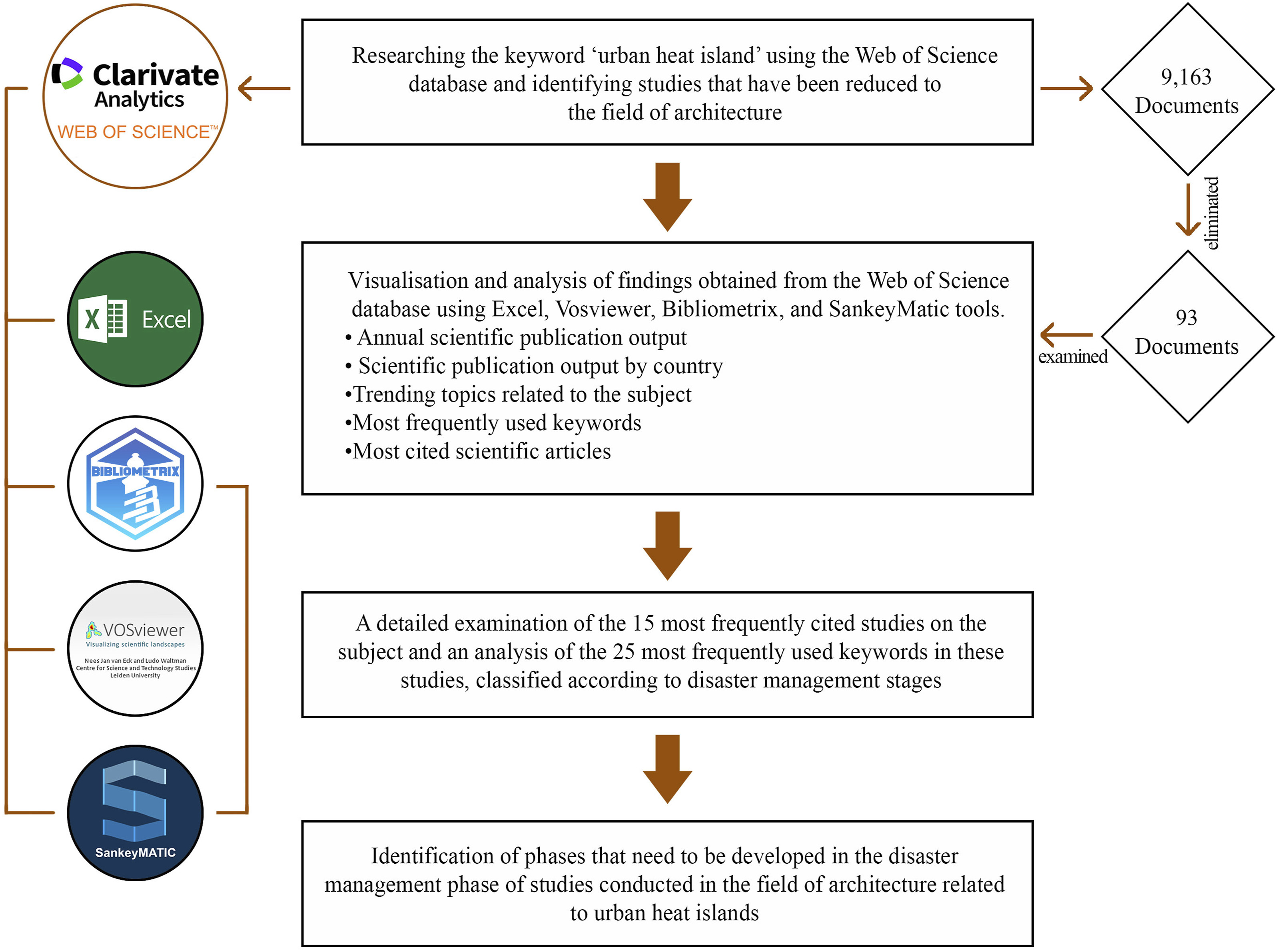
Materials and methods
This study is targetting to examine the existing literature on UHI and architecture using bibliometric analysis methods also classify the studies according to disaster management phases, and identify areas for improvement in the existing literature. The study searchs to seek answers to the following two main questions: What is the current state of studies on the concept of UHI in the field of architecture, and what are the gaps in the literature in this area? How does the UHI, as one of the critical impacts of climate change, have a place in disaster management in the framework of architecture? In this framework, bibliometric analysis used in this research is a quantitative method that assesses and analyses data from various disciplines based on bibliometric data. 13 Through literature reviews based on large data sets, it provides a comprehensive and systematic perspective on a specific research area. These analyses not only find out the general view of the existing scientific literature but also enable research topics to be determined objectively and quantitatively. 14 In this way, scientists can develop innovative research ideas, identify gaps in the literatüre, and strategically position their work to make meaningful additions to the field. 15
Database selection and scientific mapping tools
For the make a bibliometric analysis, firstly necessary to determine the most appropriate data source for the research area. The first comprehensive international bibliographic database in this field is WoS. WoS is being one of the leading platform globally that contains scientific citation indexing, exploration and analytical knowledge developed by Clarivate Analytics. WoS is widely used in scholar studies and also serves as a dataset for large-scale, data-intensive studies covering multiple disciplines. 16 WoS selected for data source in this study due to its broad coverage of research areas, accessibility, and compatibility with bibliometric analysis software such as VOSviewer.
VOSviewer, SciMAT, Sci2 Tool, Bibexcel, BiblioMaps, and Biblioshiny are the most widely used science mapping tools for conducting effective bibliometric analysis today. These tools produce various analysis outputs based on their specific features, and users must select the one most suitable for their purposes. Biblioshiny is a free, web-based graphical interface that featured of its wide range of analysis options developed by Bibliometrix, 17 Microsoft Excel is an effective tool for cleaning, classifying, and visualising bibliometric data in the initial phases, it provides in data pre-processing and basic analysis with the convenience of it. VOSviewer facilitates the interpretation of large-scale bibliometric maps with its ability to import data from multiple sources and its visualisation power. 18 The SankeyMatic programme increases the readability of network structures by visualising multidimensional connections through Sankey diagrams representing data relationships and reflects the amount of data with connection widths. 19
Data collection and processing process
In the first phase of the study, the keyword ‘urban heat island’ was selected and searched in the WoS database. In the initial search using this keyword, studies in the form of articles in the English language were examined without any field restrictions, resulting in a total of 9,163 publications. The majority of the data obtained was concentrated in the disciplines of Environmental Sciences,20,21 Meteorology Atmospheric Sciences,22,23 Urban Studies24,25 and Geography26,27 Figure 2. In this context, when the 9,163 studies obtained were examined, it was seen that only 93 studies were within the scope of the architecture discipline and were quite limited in number compared to other fields Table 1. Accordingly, the study selected the discipline of architecture, where there is a potential gap in the field of UHIs, in order to identify existing deficiencies and possible gaps, determining possible research to be conducted in this field, and proposing possible measures to be implemented. Furthermore, addressing the topic of UHIs from perspective of architecture presents an innovative research approach, given the limited number of studies on this subject in the existing literature. Number of studies on the topic of UHIs in English-language articles by discipline. Keyword search in bibliometric analysis.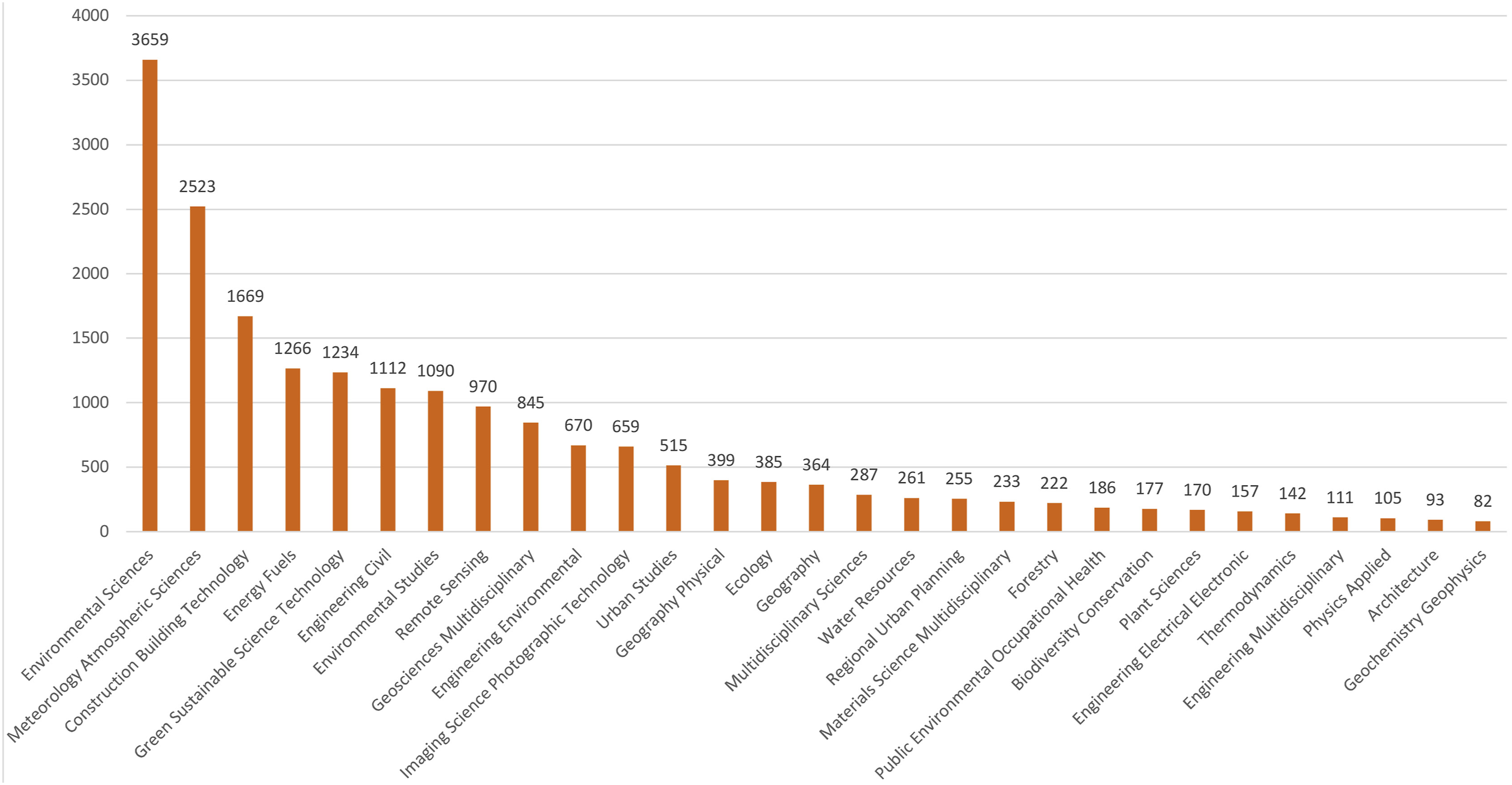
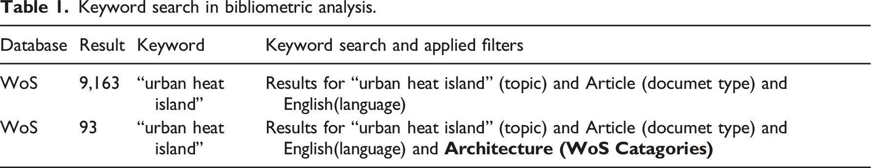
A bibliometric search conducted on 26 March 2025 in the WoS database using the keyword ‘urban heat island’ identified a total of 9,163 studies that included this phrase in the subject heading, were published as articles, and were written in English. In order to reveal the literature related to the discipline of architecture, only studies classified under the architecture discipline in the WoS category were filtered from these results, and 93 articles were identified within this scope. The analyses conducted in the continuation of the study were carried out on these 93 studies.
In the next phase of the study, the WoS data of the 93 studies were examined and visualised using bibliometric analysis tools such as Excel, VOSviewer, Bibliometrix and SankeyMATIC. Within this scope, annual scientific publication output, countries’ scientific publication output, trending topics related to the subject, the most frequently used keywords, and the 25 most cited scientific articles were identified. Subsequently, the 25 keywords that emerged from the analyses and the 15 most cited studies globally were examined in detail; both sets of findings were classified under the four basic phases of disaster management: prevention, preparation, emergency response and recovery. In the final phase, the analysis of the findings revealed the phases of disaster management in which studies on UHIs in the field of architecture are concentrated, and the phases that need to be developed were identified.
Disaster management cycle and UHI effect
Many regions of the world have areas with high building density and large populations, and these areas pose significant risks when disasters occur. Disaster management focuses on minimizing the long-term impacts of disasters on property and human life. There are various ways to reduce disaster risks, and at this point, the development of technology and disaster management phases are of great importance. Disaster management consists of four basic phases, each with specific objectives and resources: mitigation, preparation, emergency response and recovery. These phases are classified as pre-disaster and post-disaster depending on the occurrence of the disaster and aim to minimise the negative effects of disasters when implemented effectively10,12,28 (Figure 3). Phases of the disaster management cycle
29
.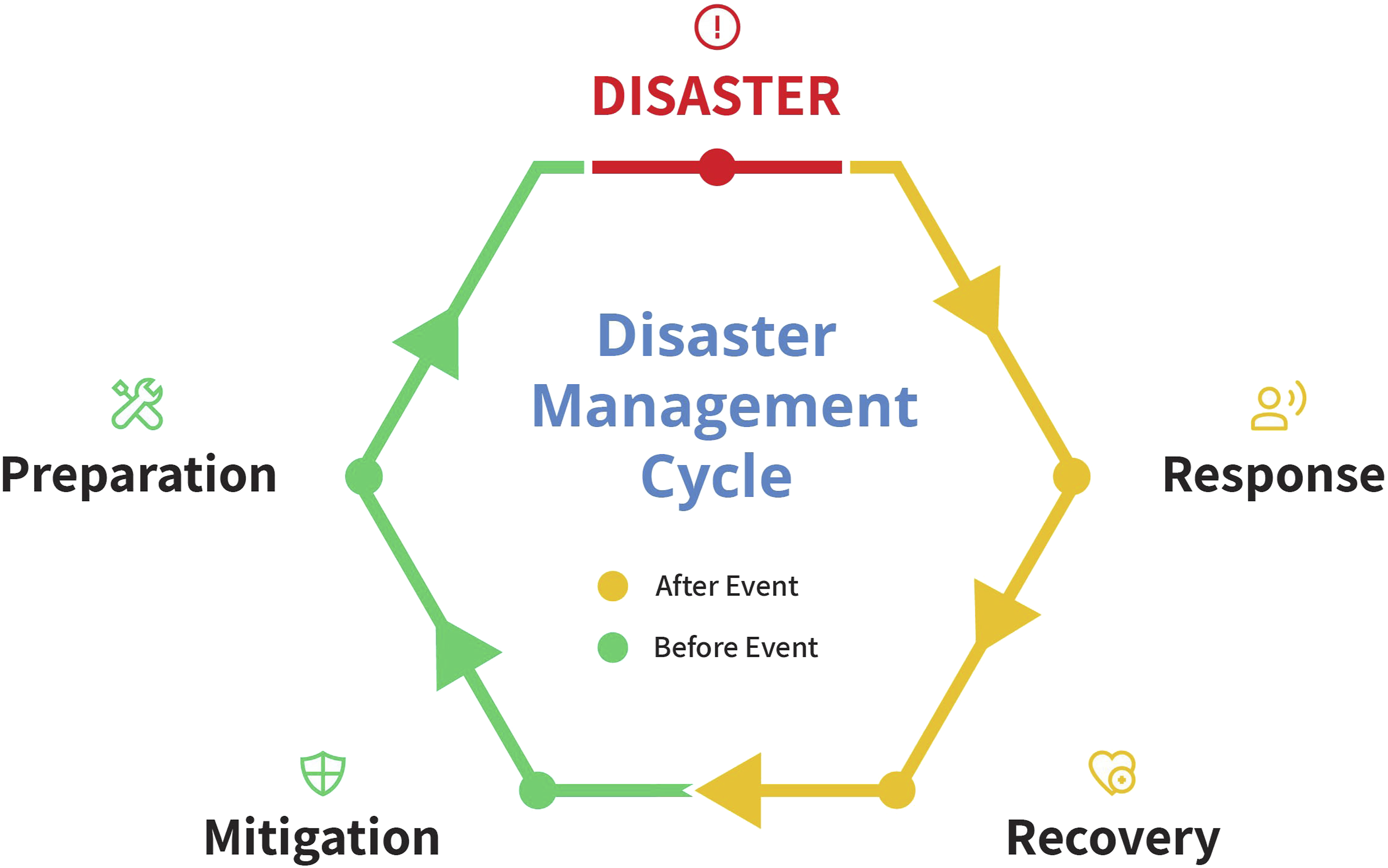
The definition of disaster management phases and examples of their application in relation to the 15 studies examined in the following sections of this paper are provided below.
Mitigation phase
This phase covers measures taken to prevent or reduce the causes, effects and consequences of disasters. This process aims to ensure that the ecosystem and the social system created by human communities remain strong and balanced. There is some measures to reduce UHIE enhancing green areas and afforestation in cities,30,31 using reflective and non-heat-absorbing coating materials for building roofs and roads, 32 the use of vertical gardens and green roofs,33,34 increasing the use of urban furniture and tree planting that provide shade, 35 applying urban planning planning precautions to mitigate the UHIE in areas where it is most distinct,32,36,37 and promoting the use of permeable surfaces. In this context, countries have developed various applications to mitigate the UHIE. For example, in Singapore, wind corridors have been planned and tall buildings and green areas are strategically positioned to allow free airflow in the city, for the aim of mitigate the UHIE. 38 In Tokyo, the “Green Roof Mandate” law requires at least 20% of all new buildings larger than 1,000 m2 to have green roofs in order to mitigate the UHIE. 39
Preparation phase
This phase includes education and awareness-raising activities conducted before the disaster to increase preparation for potential disasters. This phase is a pre-disaster process during which preparation plans are developed, the public is informed, and education and drill activities are conducted. In the preparation phase aimed at mitigating the UHIE, the following measures are implemented: developing early warning systems against extreme weather events, establishing strategies for the sustainable management of water and energy resources,
35
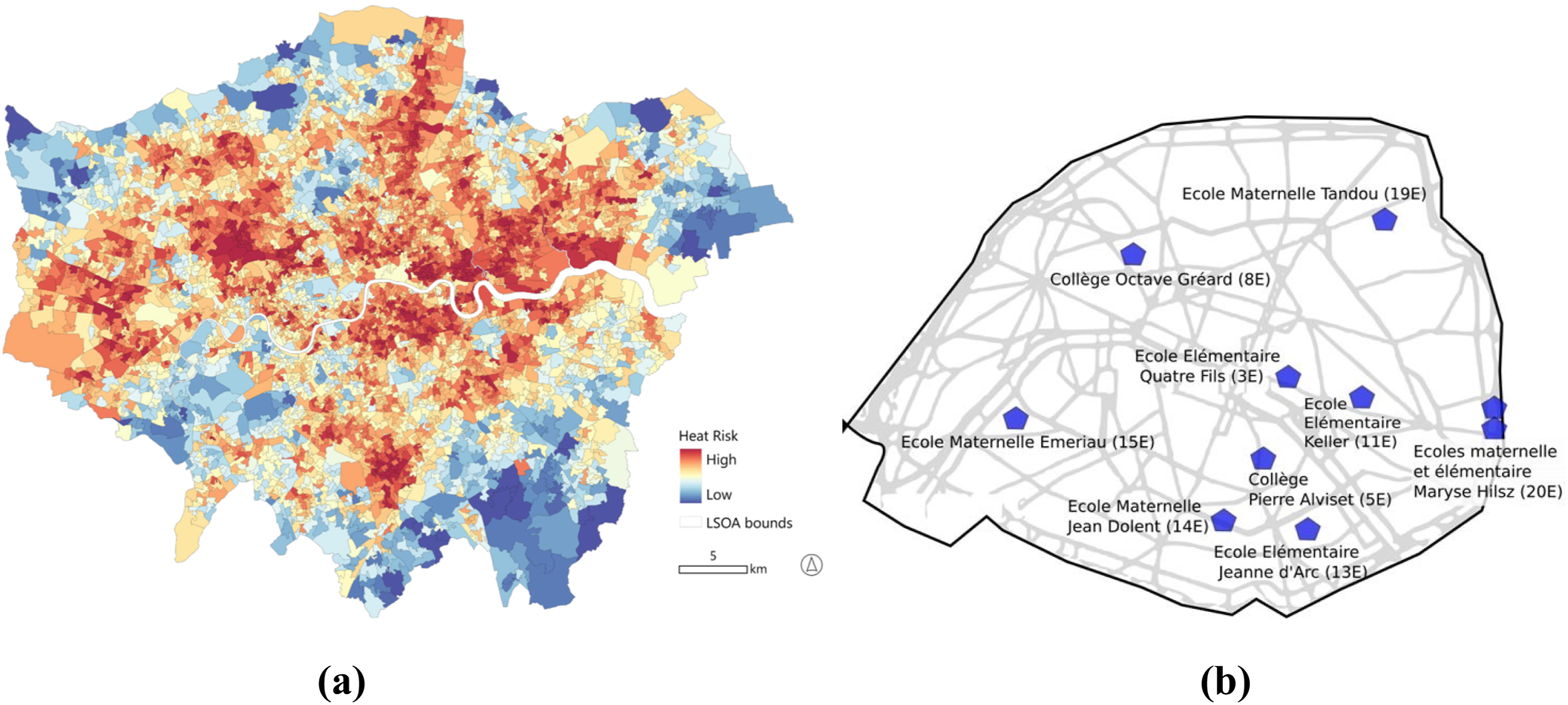
developing various greening strategies for urban areas,31,34,40 preparing the region/area for the UHIE using simulation programmes,9,41–45 and informing the public about extreme heat are examples of measures that can be taken during this phase. In this context, many countries have developed various applications focused on the preparatory phase for mitigating the UHIE. For example, the London City Council has created urban heat risk maps using Geographic Information Systems, enabling the identification of high-risk areas and the development of priority emergency response plans Figure 4(a).
46
In the city of Paris, France, school gardens have been transformed as part of the Openness, Adaptation, Sensitisation, Innovation and Social ties (OASIS) project to create a network of urban cooling points that can be used during periods when the city experiences heatwaves Figure 4(b).
47
Emergency response phase
The emergency response phase comprises rapid actions initiated immediately after a disaster to mitigate short-term impacts. In the emergency response process aimed at mitigating the UHIE, key measures include conducting rapid risk assessments to alleviate the negative impacts of extreme temperatures, implementing pre-prepared emergency action plans, opening cooling centres for vulnerable groups, setting up temporary shading and water spraying stations, and activating early warning systems.30,37 In this context, the main reason for positioning the selected examples in the intervention phase is that these practices offer concrete measures that are implemented during or immediately before extreme heat events, rather than long-term planning or preparation strategies. For example, the City of Melbourne and the Bureau of Meteorology in Australia have developed a ‘Cool Spots Map’ to inform the public about where cooling and water facilities are located on hot days, and an early warning system that issues official warnings when a severe or extreme heatwave is expected in at least 10% of the airspace.
48
In Vancouver, Canada, cooling centres housing public facilities have been established for use during extreme heat waves Figure 5(a).
49
These examples demonstrate that emergency response strategies are not limited to warning and planning mechanisms but can also be integrated into architectural practice through public space design and temporary structures Figure 5(b).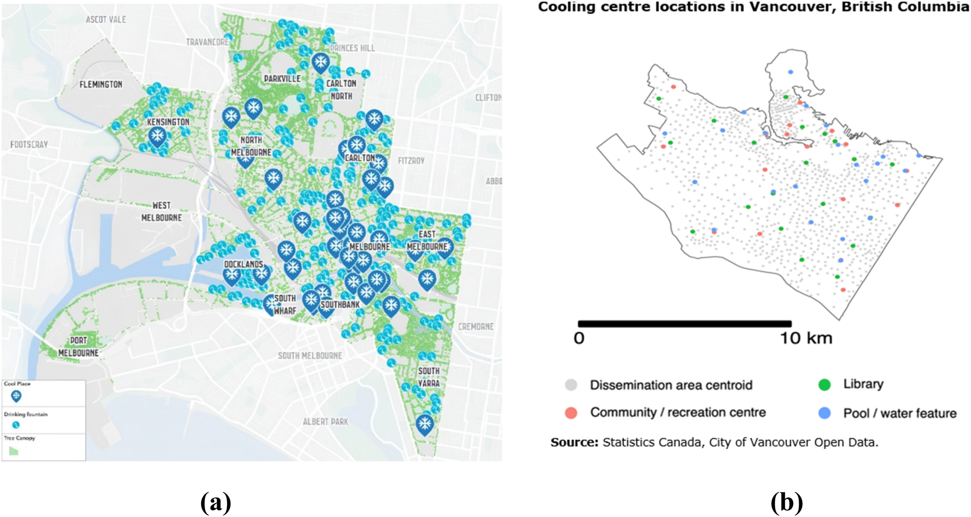
Recovery phase
This phase encompasses activities that facilitate the return to safe living conditions and a normalised socio-economic order in the disaster-affected area. During this process, repair and reconstruction efforts are carried out concurrently with daily life. In the recovery phase aimed at reducing the UHIE, efforts include minimising the existing heat island effect in urban planning by increasing green infrastructure, 30 renovating buildings and roads with high-reflectivity materials, and developing mitigation strategies in fields where the UHIE is concentrated by reviewing existing urban planning9,32,42 are examples of measures that can be implemented at this stage to mitigate the long-term consequences of UHIE and create more durable and sustainable living conditions in affected areas.36,37 In this context, many countries have developed various applications to improve the UHIE. For example, Los Angeles has started painting asphalt roads and pavements with special light-coloured coatings for mitigate surface temperatures, thus that implements reduced heat absorption and taking emergency response to mitigate the UHIE. 50
Findings
As a result of a search in the WoS database which conducted on 26 March 2025, 93 studies were identified related to the field of architecture, and these data were transferred to the Biblioshiny visualisation tool to produce Figure 6. The figure presents the bibliometric profile of a total of 93 studies in the field of architecture between 2006 and 2025. These studies were obtained from 33 different sources, with a total of 273 authors contributing, and 17.2% of the publications were carried out with international co-authorship. Key information related to the keyword “urban heat island”.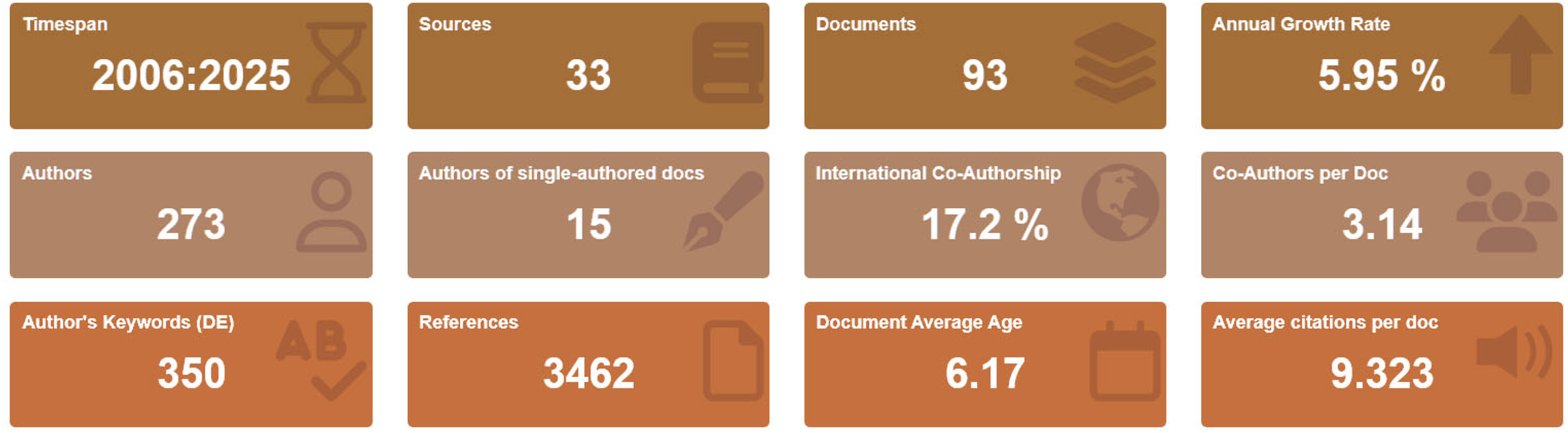
Annual scientific publication output
This graph was created to analyse data obtained from the WoS database using the keyword ‘urban heat island.’ In these graphs, 93 publications related to architecture were examined from 9,163 publications using the keyword ‘urban heat island.’ When examining the publication years of studies in the field of architecture using the two keywords, the trend line for publications from 2006 to 2025 shows a steady increase. The growth in the volume of publications, particularly after 2016, reached notable levels with studies in 2019 and 2022 Figure 7. Number of scientific publications by year.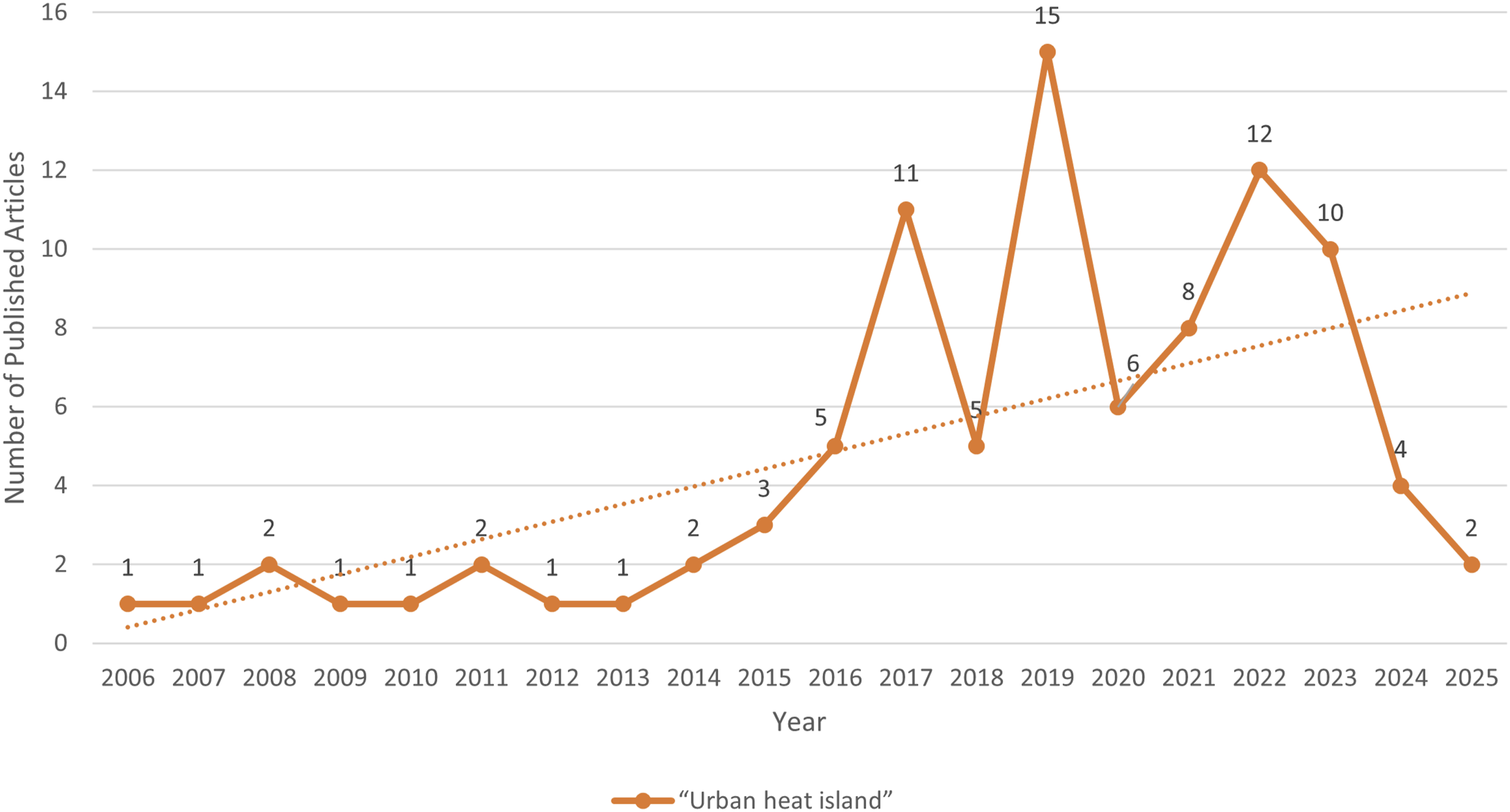
Scientific publication output of countries
The examination of which countries produce scientific publications containing the keyword ‘urban heat island’ is of great significance in revealing study trends and global awareness in this field. Figure 8(a) indicates that China, the United States, Italy, Turkey and Australia are among the leading countries in this field. It is noteworthy that China has the highest number of publications. The second visual, the world map Figure 8(b), visually presents the geographical distribution of these countries and the global spread of studies on the UHI phenomenon. The areas marked in dark colours on the map represent regions with high publication density. This distribution reveals that the UHI problem is not a topic limited to specific continents or levels of development, but rather a global issue addressed in different geographical and climatic regions. (a) Number of publications by country for the keyword ‘urban heat island’ (b) Mapping of countries according to the number of publications.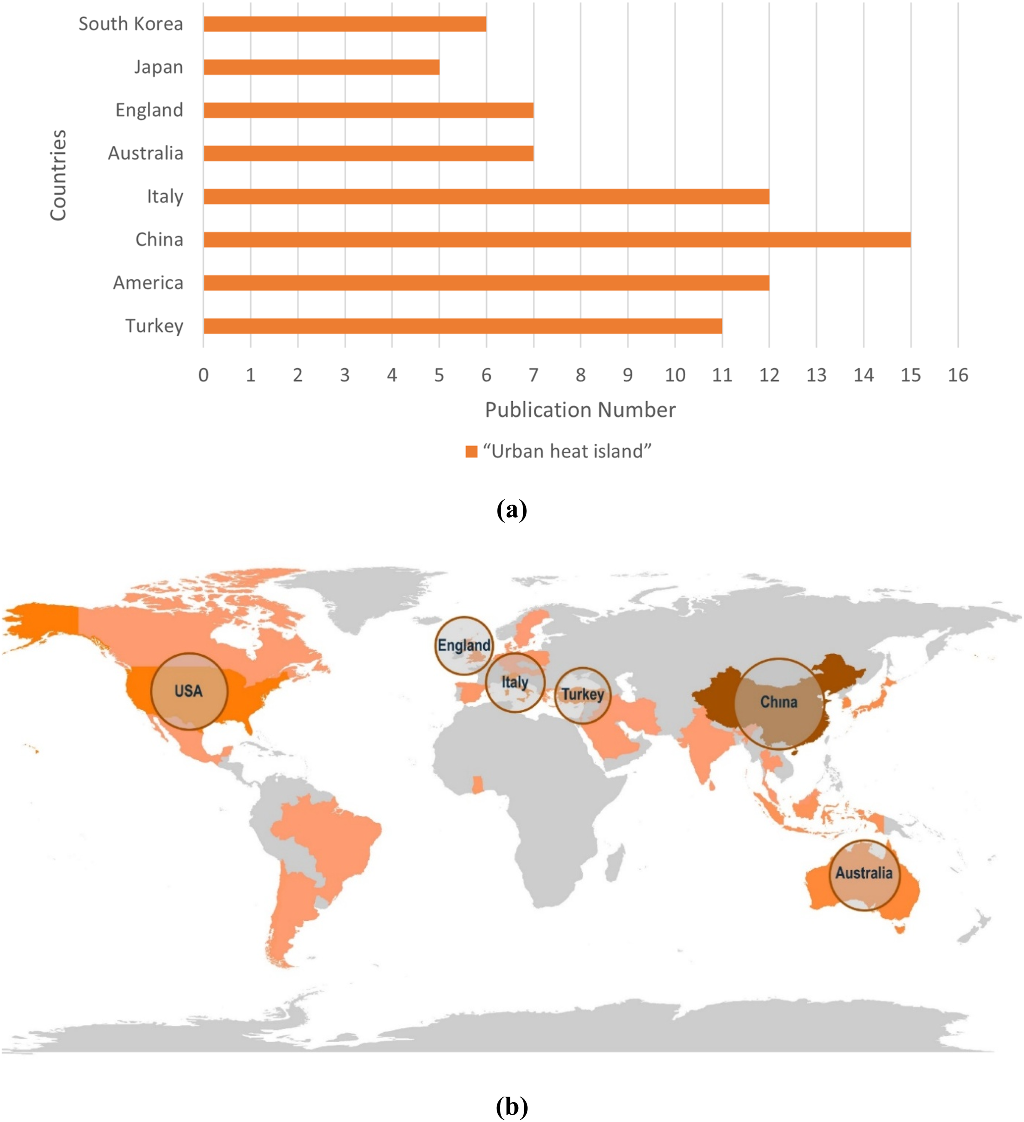
When examining Figure 8(a) and 8(b), it is observed that publications are predominantly concentrated in Asia, Europe, and North America, while a large part of the African continent, a substantial region in South America, and certain parts in the Middle East have low publication density. When the countries studied are evaluated in terms of climate, it is seen that publications are mostly concentrated in temperate climate regions, whereas there are fewer studies in arid climate zones (e.g. the Middle East and the interior of Africa) and humid areas (e.g. Central Africa and northern South America). Although this climatic and geographical distribution reveals that the UHI issue is significant at different geographical regions, it also indicates that there are significant research gaps in some regions.
Trending topics related to the subject
When examining the trend titles used in scientific publications containing the keyword ‘urban heat island’ Figure 9, it is observed that ‘thermal comfort’ was prominent in 2018, ‘urban heat island’ in 2019, and titles such as ‘envi-met,’ ‘simulation,’ ‘urban,’ and ‘surface temperature’ in 2021 and beyond. In this context, it is observed that studies that initially began with fundamental topics such as climate change and heat islands have gradually shifted toward more applied fields such as surface temperature, simulation, and urban. Trend titles by year.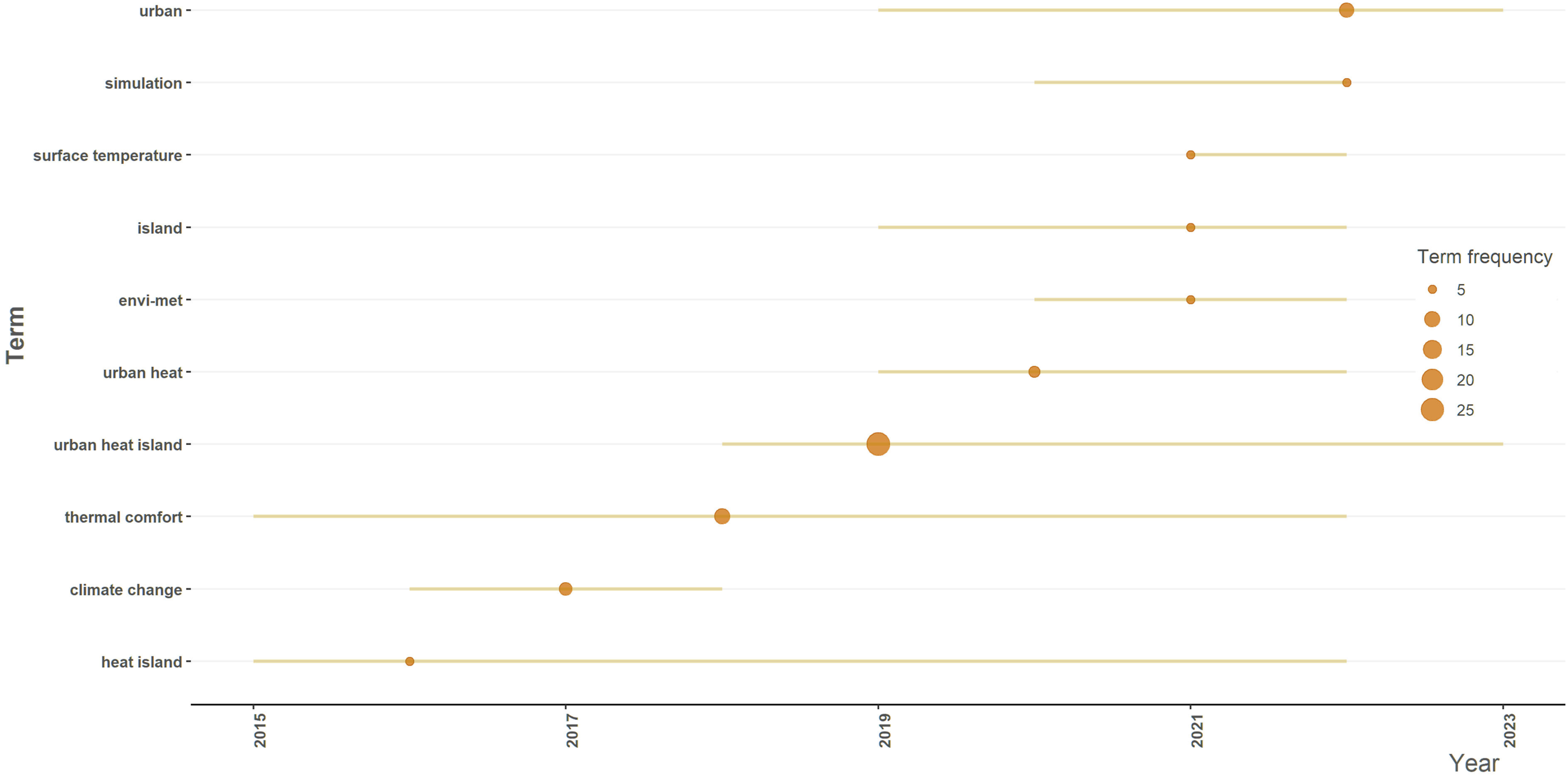
Analysis of the most cited scientific articles and their classification according to disaster management phases
Figure 10 shows that the publication by Soltani et al.
30
is the highly referred article with 122 references, followed by the publication by Yuan et al.
9
in second place with 80 references. The citation counts of other studies range from 35 to 11, with Mavrogianni et al.,
41
Di Giuseppe et al.
33
and Zhang et al.
42
In addition, the publication years of these 15 most cited articles are concentrated between 2010 and 2023, which may indicate that the topic is receiving increasing attention in the literature. In the study, 15 studies with the most of citations were chosen from 93 studies obtained from the WoS database without any temporal or thematic restrictions and were examined in detail. To determine which disaster management phase or phases the 15 most cited articles are associated with, these studies were analysed in detail, and the relevant disaster management phase or phases are shown in Table 2. Top 15 most cited articles. Analysis of the top 15 most highly studies.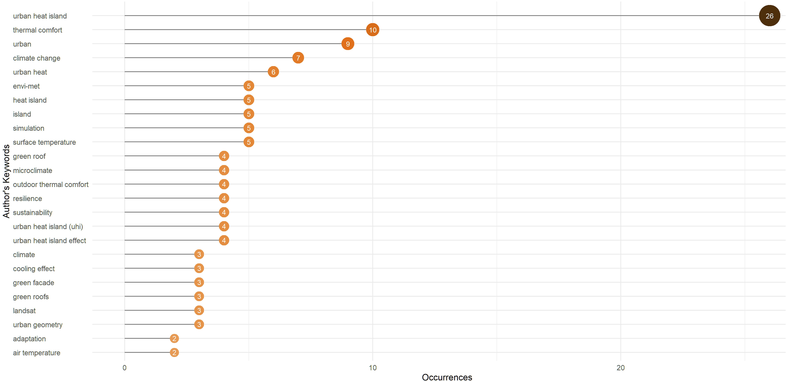
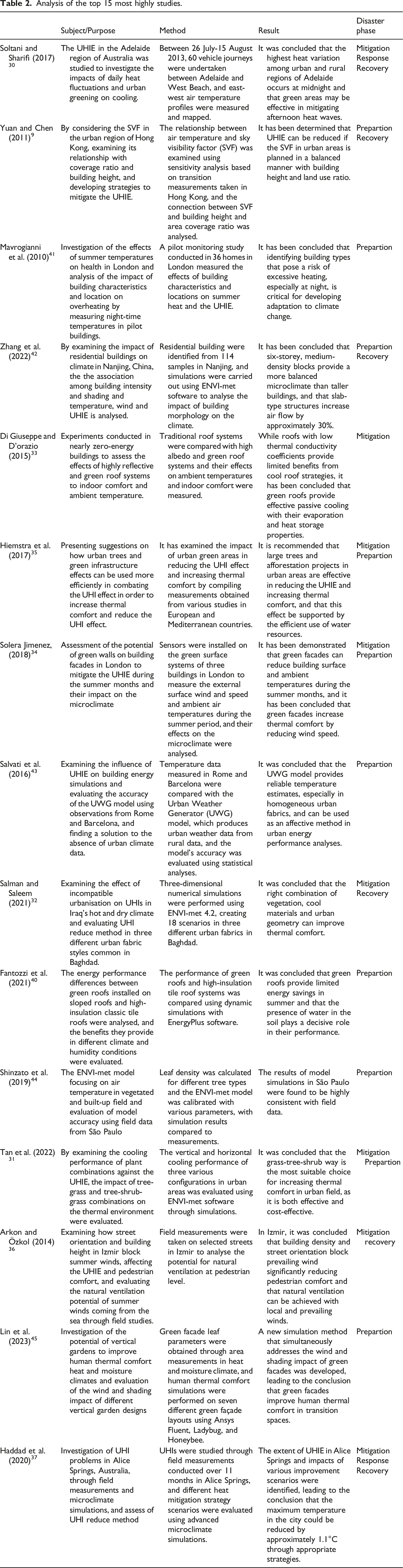
When examining the relationship between studies and disaster management processes (Table 2), it was determined that studies conducted during the damage reduction phase focused on issues related to mitigating the existing UHIE or the factors causing this effect in a specific area or region. In the preparation phase, it was observed that areas at high risk of being affected by the UHIE were identified, analyses were conducted using simulation programmes, and new strategies were developed for elements that could contribute to the UHIE. In the improvement phase, it was observed that various improvement strategies were developed for areas currently impacted with the UHIE, while in the emergency response phase, it was noted that efforts were focused on developing emergency response strategies aimed at reducing the existing UHIE.
When examining Figure 11, which shows which disaster management process the studies are included in, it is seen that the highest percentage (33.4%) is in the preparation phase. The strong overlap between preparation and mitigation (20%) indicates that these two phases are often addressed together, whereas emergency response and recovery are mostly evaluated in an integrated manner with other phases (0% for both). The fact that the reduction phase is associated with both preparation (20%) and improvement (13.3%) reflects the tendency of this phase to spread across different phases of the process, while the scarcity of the emergency intervention phase both on its own and in its intersections with other phases indicates that studies on this process are quite limited. Distribution and number of articles in 15 studies examined according to disaster management phases.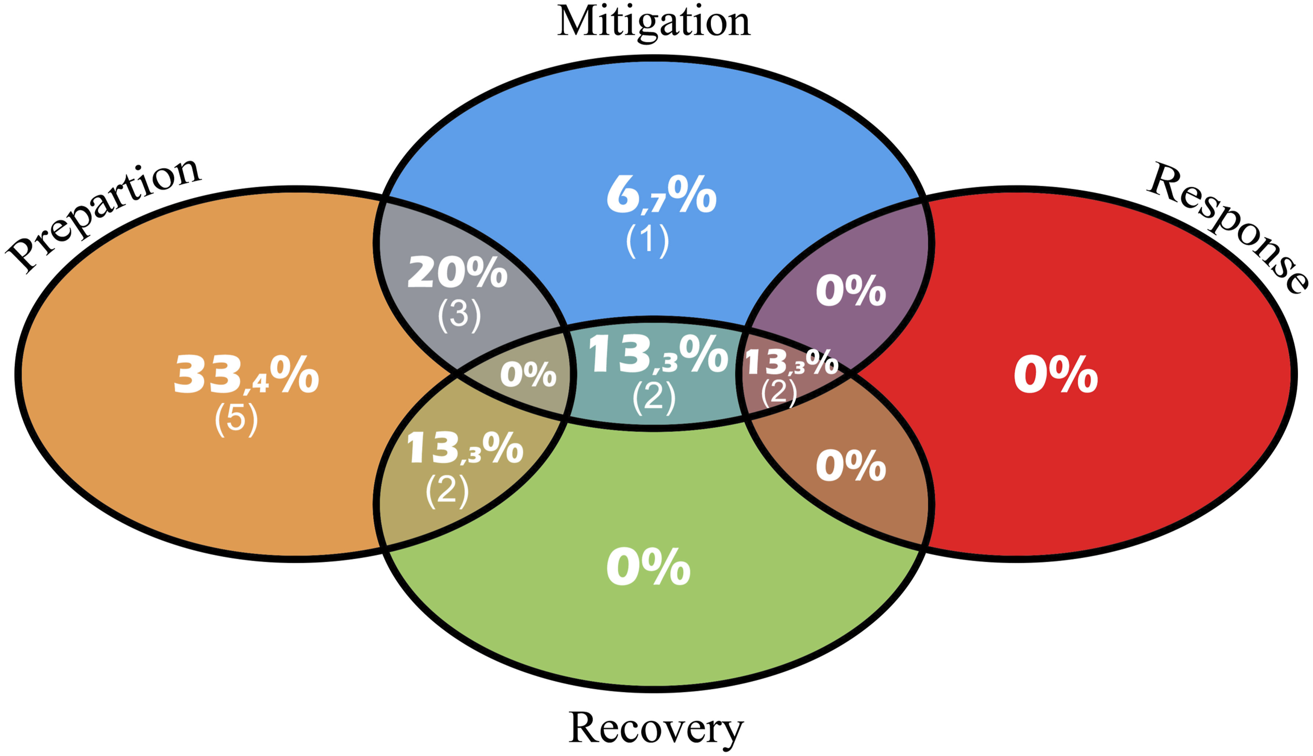
Mapping of the most frequently used keywords and classification according to disaster management phases
When examining the most frequently used keywords in the scope of UHI and architecture Figure 12, it is observed that the keywords ‘thermal comfort’ and ‘urban heat island’ stand out. However, among the 15 most frequently used keywords, it is observed that ‘Landsat’ from satellite imaging systems and ‘Envi-met’ from simulation software are the only keywords that stand out in these two areas. The 25 most frequently used keywords.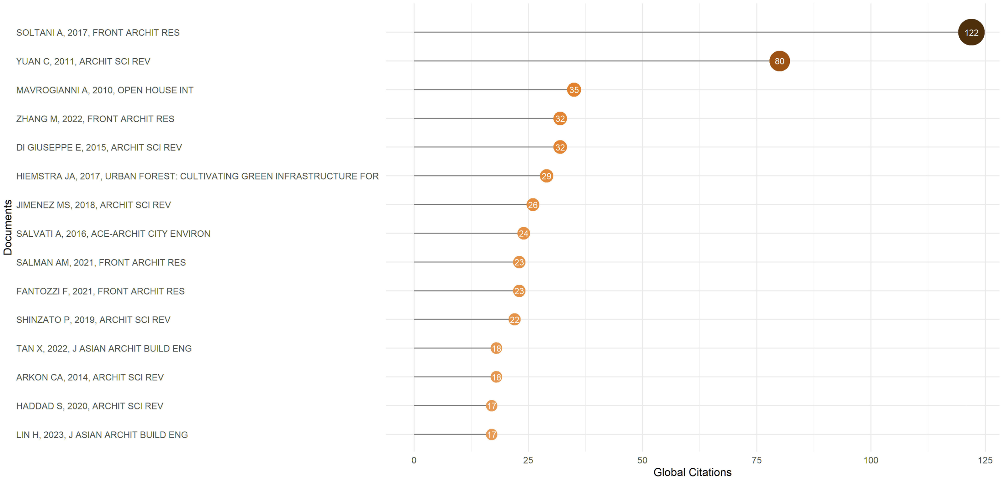
Co-occurrence analysis based on keywords is an exploratory method for understanding conceptual field network and scholarly collaborations among author keywords in a specific field, identifying themes, and revealing new areas of research.
51
Through this analytical approach, the expansion of research fields, new gaps in certain disciplines, new keyword connections, and transformations that emerge over time can be understood. In this analysis, clusters and cluster sizes represent keywords. The connections between clusters represent the relationships between keywords. The thickness of the network line increases according to the total connection strength between keywords.
13
Data downloaded from the WoS database with the restriction of the keyword ‘urban heat island’ in the field of architecture was transferred to the VOSviewer software. In the software, the minimum transition number for a keyword was set to 2. As a result of this limitation, the software reduced the number of keywords from 334 to 46. Then, it created a keyword map using 46 keywords Figure 13. When the created map was examined, the 25 most frequently used keywords in the studies were found to be heat island, simulation, thermal comfort, city, urban heat, envı-met, island, surface temperature, green roof, microclimate, outdoor thermal comfort, climate change, resilience, sustainability, urban heat island effect, climate, cooling effect, green facade, green roofs, Landsat, city geometry, adaptation, and air temperature. Keyword map created by limiting ‘urban heat island’ data in architecture.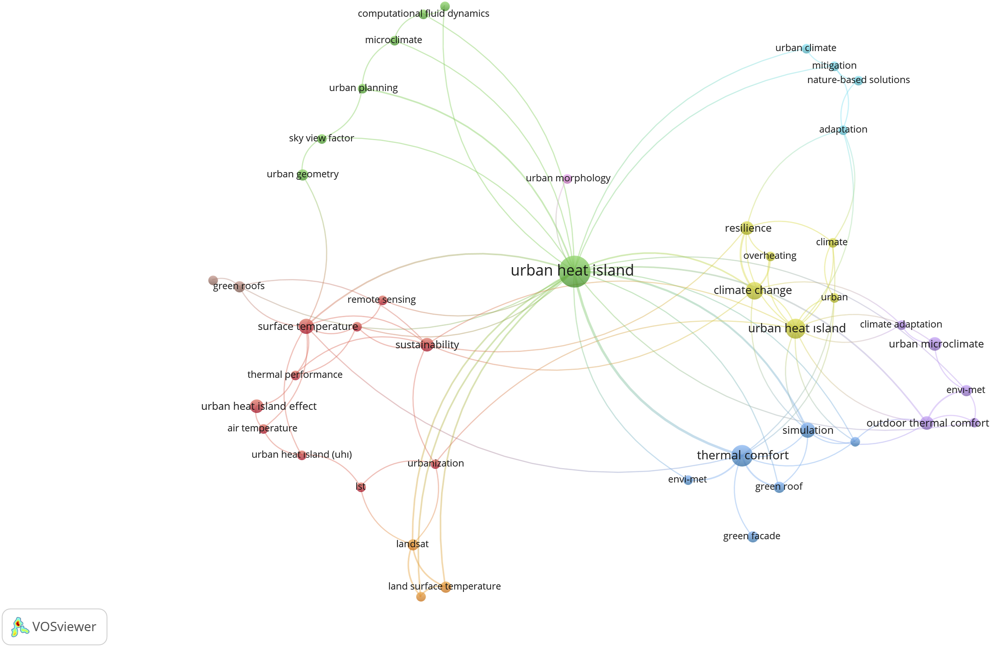
Classification of keywords according to disaster management phases
The 25 most frequently used keywords in 93 studies obtained from the WoS database were classified according to the four basic phases of disaster management. During classification, the keywords in the 15 most cited articles were examined, and the disaster management phase was determined based on the use of the 25 keywords in the studies according to the classification in Table 2, and matching was performed Figure 14. Some keywords may appear in more than one phase as a result of the matching process. This intersection is visualised and discussed in Figure 15. Sankey diagram of the years in which keywords were used and the phases of disaster management. Distribution and number of keywords determined according to disaster management phases.
The temporal change in keywords used in academic studies focusing on the UHI issue between 2006 and 2025 and how these keywords are related to the four basic phase of disaster management (Mitigation, Preparation, Emergency Response and Recovery) are visualised through a Sankey diagram and graphs. When examining Figure 14, it is observed that the literature was particularly concentrated around the keyword ‘Urban Heat Island’ in the early years. But, there has been a considerable rise in the quantity of keywords since 2014 and this increase reaching its maximum level between 2022 and 2024. The increase in keyword diversity indicates that the heat island phenomenon has begun to be addressed in different dimensions over time. While more notional keywords such as ‘thermal comfort,’ ‘city,’ and “sustainability” were featured in the early years, nature-based approaches such as ‘green facades’ and ‘green roofs’, nature-based approaches and concepts such as ‘ENVI-met,’ ‘Landsat,’ and ‘simulation,’ which involve remote sensing systems and modelling approaches fetured in subsequent years. This transformation demonstrates that urban heat island studies have moved away from their initial notional framework and evolved into a more application-oriented, solution-focused, and multidisciplinary field of research over time.
When examine the matching of keyword and disaster management phase in Figure 14, it is seen that the keywords with the broadest coverage are ‘Urban heat island’ and ‘Urban heat island effect’, are present throughout all four phases. That demonstrates the UHI phenomenon acts a comprehensive role for disaster management process in terms of risk reduction, preparation, emergency response, and recovery. The evaluation of keywords which offer micro-scale analysis and simulation capabilities such as ‘Envi-met’ and ‘Microclimate,’ in three different phases reveals that these tools are used in planning, mitigation, and recovery processes. The keywords ‘green roof’, ‘green facade’, ‘cooling effect’ and ‘urban geometry’ are mainly found in the mitigation and recovery phases. Keywords such as “simulation”, ‘climate change’ and ‘climate’ are only matched in the preparation phase indicates that these concepts are come up with more in the context of risk assessment and planning. However, the keywords ‘urban,’ ‘urban heat,’ ‘island,’ ‘surface temperature,’ ‘Landsat,’ ‘air temperature,’ ‘resilience,’ and ‘sustainability’ could not be associated with any phase because they were not used in the 15 most cited studies. Conversely, the keywords ‘urban,’ ‘urban heat,’ ‘island,’ ‘surface temperature,’ ‘Landsat,’ ‘air temperature,’ ‘resilience,’ and ‘sustainability’ could not be associated with any phase because they were not used in the 15 most cited studies.
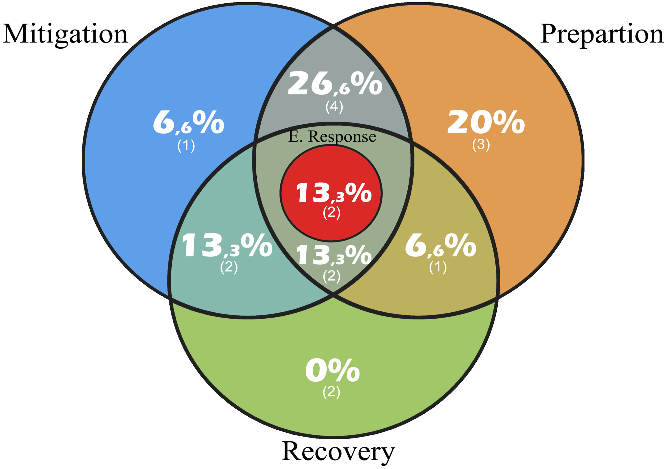
Figure 15 illustrates the relationships between the keywords examined and the four fundamental phases of disaster management (mitigation, prepartion, emergency response, and recovery) using a Venn diagram. The diagram expresses the individual contribution of each phase and its intersections with other phases as percentage ratios. The highest ratio, 26.6%, is found in the intersection of the mitigation and prepartion phases, indicating that risk mitigation and prepartion processes are areas of intense focus. While the prepartion phase alone accounts for a significant share of 20%, the mitigation phase contributes only 6.6% and the recovery phase a limited 0%. The emergency response phase, located at the centre of the diagram, is represented by only 13.3%; this reveals that, despite being associated with every phase, it remains limited in the literature. The low representation of the emergency response phase, despite its critical role intersecting with all other processes, indicates that post-disaster emergency actions are given less attention. Furthermore, the overlaps observed at the intersection of mitigation, prepartion, emergency response, and recovery (13.3%) emphasise that the response process serves a supportive function but has limitations when considered in isolation. Figure 15 demonstrates that the emergency response phase in disaster management must be addressed more robustly and comprehensively, both independently and in conjunction with other processes, to achieve sustainable disaster management.
Evaluation
In this research, a systematic bibliometric analysis was carried out understand the position of the UHI concept in the literature and the trends in studies within the framework of the architecture discipline. Various analyses and evaluations were made by examining 93 studies identified in WoS database between 2006 and 2025 within the scope of UHIs and the discipline of architecture, and the relationship of the subject with disaster management was examined. In this section, based on the findings discussed, the research trends in UHI and architecture in relation to disaster management phases were evaluated.
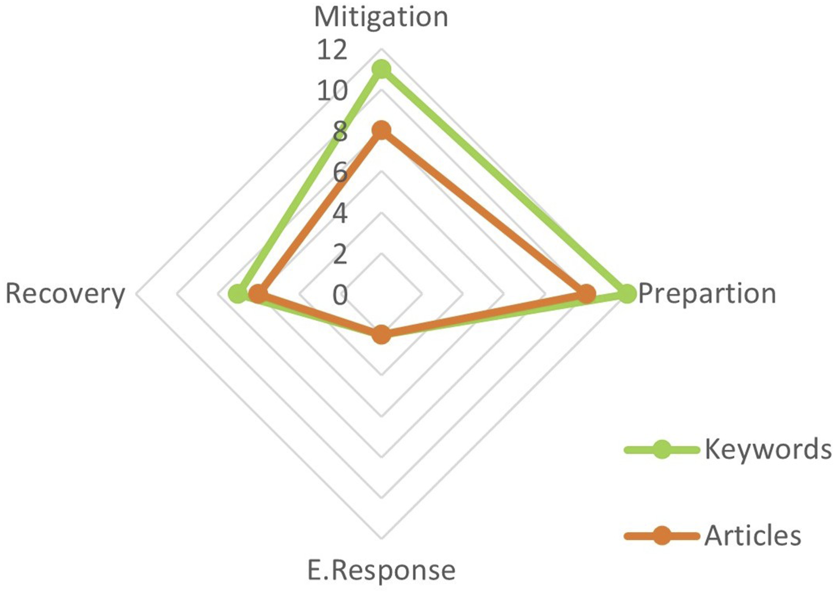
When evaluating the relationship between, the keywords used in UHI in the context of architecture and the phases of disaster management at Figure 16, it is seen that the keywords are mostly related to the ‘mitigation’ and ‘prepartion’ phases. The study specially highlights the dominance of the mitigation phase, where the focus is on the notions such as climate change, urban heat islands, cooling effects, green roofs and green facades. In this context studies on urban heat islands and climate change shows that are largely focused on reducing risks and developing preventive strategies. The inclusion of simulation, outdoor thermal comfort, and microclimate which more technical and measurement-based keywords in the preparation phase, shows that this phase is associated with planning activities. In the recovery phase, the keywords thermal comfort and adaptation are prominent indicating that approaches aimed at improving post-disaster quality of life are prioritised. In contrast, the lack of meaningful representation of the emergency response phase is a notable void. The absence of the emergency response phase reveals that direct actions during disasters are not sufficiently addressed in the urban heat island and architecture literature, with studies tending to focus more on preventive and improvement dimensions. The absence of the emergency response phase reveals that direct actions during disasters are not sufficiently addressed in the UHI and architecture literature, with studies tending to focus more on preventive and improvement dimensions (Figure 17). Distribution of matched keywords according to disaster management phases. Distribution of studies examined according to disaster management phases.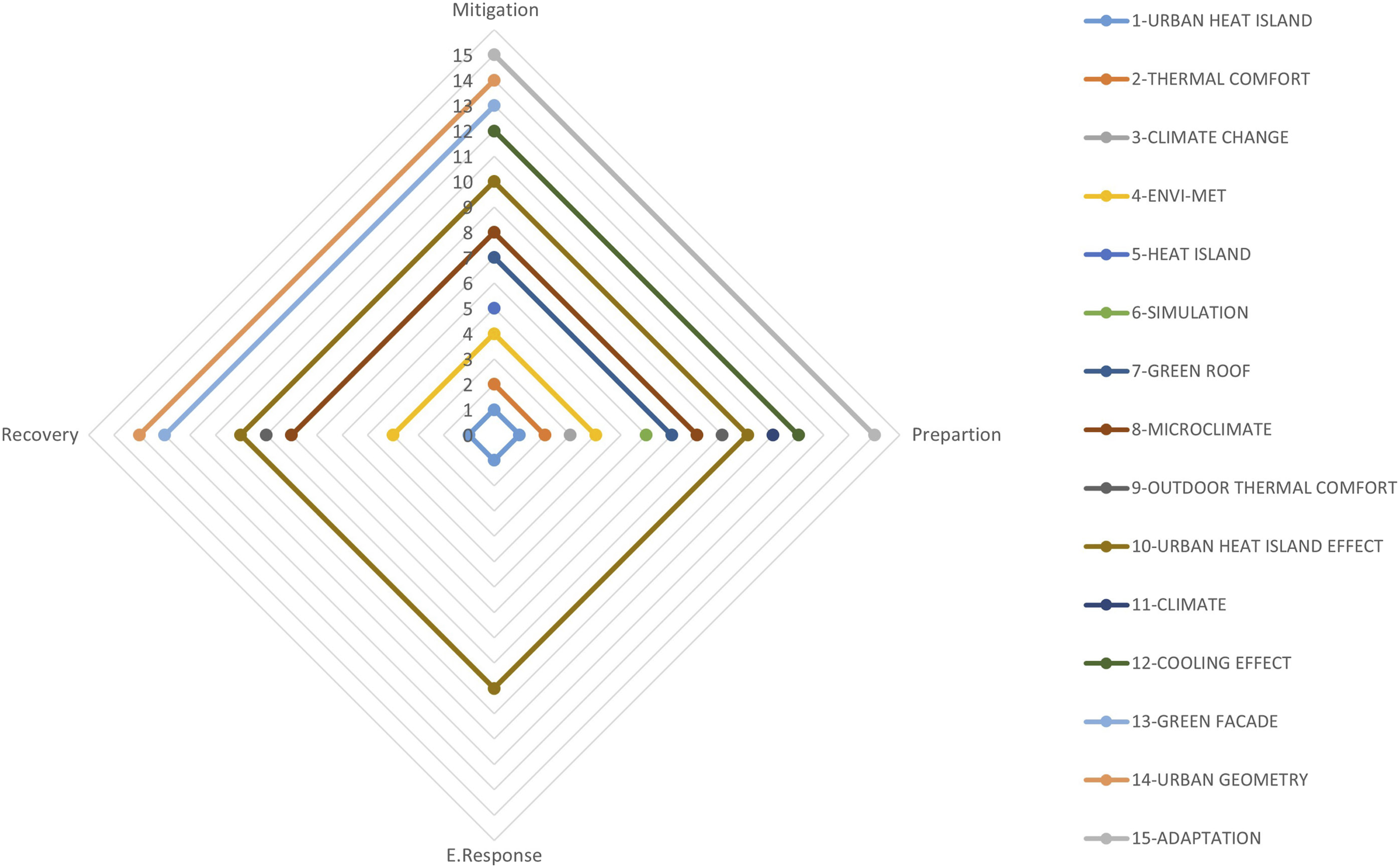
The outcomes of this study show a significant concentration of research focusing on mitigation and preparation phases in the management of the UHI effect, but studies related to the intervention phase remain limited. One reason for this gap may be the limited role of architects in emergency interventions and the insufficient accessibility of data on intervention processes. In this context, architects playing a more active role in cooling shelters, temporary shading systems, adaptable public spaces, and population-based emergency response planning processes is critical to increasing urban resilience when creating resilient cities 52 and climate-sensitive cities. 53
It is thought that UHI interventions can become more effective when supported by Passive Design Guidelines, LEED/EDGE certification systems, and local regulations. For example, LEED’s Heat Island Reduction 54 encourages the use of reflective materials on roofs and hard surfaces, shading, and green roof applications, while New York City’s Local Laws 92 and 94 regulations require that part or all of roofs be equipped with green roofs and solar panels. 55 In Turkey, the Istanbul Metropolitan Municipality’s Climate Action Plan includes intervention-focused steps against UHI through green infrastructure, shaded areas, and cool roof/wall applications. 56 These policy and certification frameworks provide architects to integrate passive design and sustainable practices with emergency response strategies, ease for them to play both a preventive and intervention-focused role in mitigate the UHIE. They also demonstrate that emergency response strategies must be come up within a policy framework that is not only theoretical but also transferable to practice.
Limitations of the study
The present study involves a systematic review of research on UHIs and architecture and has certain limitations. These limitations are as follows: (1) The studies included in this review were obtained through systematic search procedures. Therefore, publications found in other databases, published in non-indexed journals, or not in English were not included in the study. (2) The study is based on literature available up to March 2025. Therefore, studies published more recently have not been included.
Despite these limitations, the study makes an important contribution to understanding the discipline of architecture in the context of the UHI and the status of the urban heat island concept, which is an important effects of climate change disasters, in the phases of disaster management. Indeed, within this scope, there is no study that directly links the UHIE to disaster management.
Conclusion
As the years pass, cities across the globe face rising risks due to intense heat waves triggered by climate change. Because of their intense populations and crucial infrastructure, urban regions experience hotter temperatures than the encompassing rural areas and are more sensitive to heatwaves because of the UHIE. In this context, the study reviewed the literature on the UHI concept in the field of architecture and evaluated the connection among the disaster management concepts and UHI. Using a bibliometric analysis method and mapping tools applied to a large dataset, the study revealed important findings regarding the UHI and architecture. According to the data obtained, it was determined that studies in this field are largely concentrated on damage reduction and preparation, while studies on the emergency response phase are quite limited, and it was concluded that this is an area that needs to be developed in the literature.
In this context, the recommendations for the development and pratctical applications of the emergency response phase are as follows: (1) For use in heat waves; community-focused and adaptable space designs (adaptable public space designs), creation of temporary shading and modular cooling areas, use of water spray systems integrated into building facades and structural elements (2) Emergency response planning using mapping and analysis tools; Creating heat island density maps and identifying priority emergency response areas using Geographic Information System data and satellite imagery.
Such applications aimed at developing the response phase of the urban heat island disaster should be developed in collaboration with architecture and other disciplines, and more work should be done on this subject.
Climate change continues to be a global disaster whose effects are felt more and more each day. This situation makes it more important than ever for future architects to be prepared and resilient to this disaster. Taking into account the UHIE and climate change, one of its most important components, is critical to mitigating the effects of this disaster. As a result this study is significant in that it contributes to the understanding of academic research in the field of architecture concerning the concept of UHIs, highlights the gap in the literature by linking the subject to disaster management with an innovative approach, and provides a foundation for future studies on UHIs.
Footnotes
Acknowledgments
We would like to thank Gazi University for making this study possible.
Declaration of conflicting interests
The author(s) declared no potential conflicts of interest with respect to the research, authorship, and/or publication of this article.
Funding
The author(s) received no financial support for the research, authorship, and/or publication of this article.