
Abstract
Urban informality remains a central challenge for those engaged in understanding and transforming global South cities. There have been calls to develop new conceptual language geared to this challenge and much debate around the degree to which it might be subsumed within global urban theory. We argue that theories of informal urbanism need to be grounded in an understanding of how it works to sustain livelihoods, moving beyond studies of informal settlement, street vending and transport to understand the synergies, interrelations and interdependencies between them. Informal vending and transport provide employment and produce cheap goods and mobility; informal settlement produces affordable housing in key locations with access and mobility. ‘Inventraset’ is a portmanteau concept that links informal vending, transport and settlement into a dynamic urban assemblage that is inventive, transgressive and settled. This model is demonstrated through an empirical study of the spatial logic of the inventraset triangle within the megacities of Manila and Jakarta. Here the informal is normal, whether displayed in the intensities of transit nodes and street markets or camouflaged within zones of exclusion. This is not an ‘informal city’ but one where informal street vending, transport and settlement are geared to formal spatial and governance structures in different ways in different neighbourhoods − an assemblage of informal/formal and of vending/transport/settlement without which the urban economy would collapse. This is a call not simply to rename the informal but to understand it as a mode of production that is more than the inverse of the formal.
Introduction
Consider a street scene (Figure 1) on the pavement of Central Avenue which lines the edge of the main campus of the University of the Philippines in Metro Manila (14°39′43.36″N 121°03′03.94″E). When the Google Street View archive begins in 2014, we find a row of pink ‘tricycles’− the cheap semi-formalised public transport that is widely used for short trips (Figure 1). A masonry wall separates the campus from the street and is used to support a number of informal street stalls. A makeshift ladder provides access across the wall to an informal settlement on the campus beyond, where the drivers, vendors and some of the customers live. The Street View archive shows that as time passes vendors have emerged, expanded or disappeared. The masonry wall is rendered and painted, new ladders are built and the rank of tricycle taxis moves up and down the street. By March 2022, there are many rounds of incremental change but the spatial interrelations between vending, transport and settlement remain. Each of these modes of production is precarious – the settlement is under threat of eviction; there are semi-regular clearances of the pavement traders; and the tricycles are contained to a very limited range and prohibited on major expressways. Yet the spatial relations between vending, transport and settlement remain − inventive and transgressive but settled within the larger spatial and governance structures. This is one small inventraset.
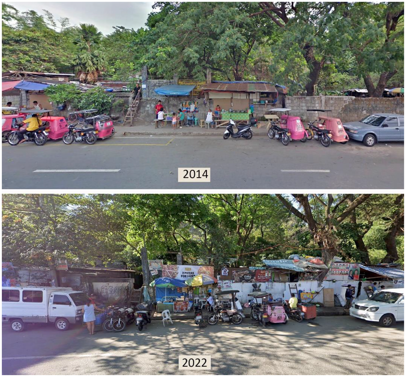
Central Avenue, Quezon City, Manila.
Those who study urban informality will recognise such synergies between informal settlement, street vending and transport. Street vendors ply their trade wherever they can find a market, and those sites will always have walkable or informal transport connections to various kinds of informal settlement where many of them live. This network of interrelations between affordable housing, shopping and transport sustains livelihoods of the urban poor, and it is crucial to the ways such cities work. Yet these interrelations and interdependencies are rarely problematised or researched. We have coined the concept of ‘inventraset’ in order to name this assemblage and to frame a new research agenda. Inventraset is a portmanteau word that stands for the multiple ways in which informal urbanism insinuates and settles into the city. We use a blended word in order to name the interrelations rather than the parts, because the integration between modes is central to the argument. ‘Inventraset’ is intended as an open signifier − more a question than an answer. It refers to the multiple ways that informal urbanism is inventive, adaptive, creative, productive, innovative and dynamic; the ways it both produces and adapts to the more formal city. Informal urbanism is transgressive – it disrupts and transforms. ‘Inventraset’ signifies a set of conditions that have become part of the settled infrastructure of the city, emerging from particular histories, morphologies and political economies as well as global geo-political conditions. This portmanteau word thus works in two registers − to connect three modes of production and to connect their resilience and resistance to their inventiveness. A concept like ‘inventraset’ can be useful to counter the tendency to focus on singular aspects of this assemblage without considering their interconnections, and it enables a better understanding of the many interrelations of informal urbanism with practices of formal governance. We propose this as a research agenda that is at once theoretical and practical; it emerges from a framework of assemblage thinking and from detailed empirical mapping to articulate the spatial logic that connects informal vending, transport and settlement on key sites within the megacities of Manila and Jakarta. We make no claim to get to the bottom of these questions, and nor do we suggest how broadly these patterns might be evident across the global South. We are keen to start conversations and investigations rather than conclude them.
Current research has taught us a lot about particular practices of informal street vending, transport and settlement. There is no scope to review this vast literature here, although the following references might serve as broad introductions in relation to street vending (Brown, 2006; Recchi, 2021), informal transport (Cervero and Golub, 2007; Evans et al., 2018) and informal settlement (Huchzermeyer and Karam, 2006) respectively. This literature on informal street vending, transport and settlement is essentially three separate discourses and research that engages across all modes of informality remains scarce (Peimani and Kamalipour, 2022). Existing scholarship has often documented the insecure and gendered access to public space by both settlers and vendors (Brown, 2006), including instances of collaboration or competition over spatial control between informal transport drivers and street vendors (Damayanti et al., 2017). Some works refer to the reliance of informal settlers on paratransit for mobility (Onyango, 2018) and on street vending for affordable, healthy food (Kazembe et al., 2019). Where scholarly engagement has touched on the relationship between the three, the discussion centres on planning/upgrading interventions (Koch et al., 2013) and land-use implications of the informal vending–transport nexus (Recio et al., 2019). The existing research closest to this article is Charman and Govender’s (2016) spatial analysis of informal enterprises in Johannesburg. With a focus on street vending, they highlight the agility and fluidity of informal entrepreneurship, underpinned by a multiplicity of largely hidden ‘organisational logics’. While they stress the centrality of spatial processes to the economic outcomes, the spatial analysis is relatively undeveloped. We have previously analysed the spatial logic of street vending, including some interconnections with transport and settlement (Dovey et al., 2022), but to our knowledge this is the first attempt to focus on these interrelationships. This work also contributes to several interconnected debates in urban studies − how to define and conceptualise informal urbanism; the degree to which global South cities require new forms of theory; and how to build a comparative urban theory from the ground up.
The concept of urban informality derives originally from economics (Hart, 1973) and embodies a broad range of contested definitions (McFarlane and Waibel, 2012; Roy and Alsaayad, 2004). It is generally defined in contrast to the formal economy and urban planning policies of the state, while also often as the result of state practices. Such definitions are contested because urban informality embodies a paradox. On the one hand it is identified with illegality, inferiority and insecurity; it is a means of providing affordable housing, transport and goods for the deregulated labour markets of neoliberal capitalism (Roy, 2005). At the same time, it is also a form of radical democracy and insurgency that embodies the right to the city (Lefebvre, 1996). Informal urbanism thus works both with and against the formal structures of the state, transgressing and transforming state practices at multiple scales. It has also long been clear that the informal/formal distinction is not binary – while we use phrases like ‘informal street vending’, ‘informal transport’ and ‘informal settlement’ as labels, we are generally looking at a complex range of intersections between formal and informal processes and practices.
There are now many terms that are used as loose synonyms for the informal −‘everyday’ (Lefebvre, 1996), ‘ordinary’ (Robinson, 2002), ‘incremental’ (Dovey and Kamalipour, 2018), ‘insurgent’ (Holston, 2008), ‘peripheral’ (Caldeira, 2017), ‘marginal’ (Lancione, 2016) and ‘popular’ (Streule et al., 2020). Most approaches tend to frame informality as the other or inverse of the ‘formal’, as if the formal were normal. Yet in many global South cities the informal is the norm. The concept of informality-in-itself remains something of a black box in urban theory. Our goal is to open that box a little and our primary lens is spatial. There are often compelling calls to focus on the broader political economy within which urban informality flourishes (Banks et al., 2020). While we acknowledge the importance of economic, social and political critique, we suggest that a focused spatial critique can provide insights that other approaches cannot. There is a tendency to relegate space to a position of presumed neutrality, while social and economic issues are seen as central to practices of power. Yet spatiality is often primary to the ways that power is rendered invisible, silently framing everyday life both literally and discursively (Dovey, 2008). We are interested in spatiality at multiple scales, with a focus on the pavement, street, neighbourhood and district where the particularities of informal urbanism are negotiated. This is not to deny broader metropolitan, national and global factors (Randolph and Storper, 2023), only to suggest that the question of how urban informality works on the ground is crucial to any form of engagement. The spatial fix is a primary response of the state when urban informality is seen as a problem to be fixed – evicting, demolishing, fencing and zoning are the primary tactics of formalisation.
There have been many calls over past decades to re-think urban theory with regard to understanding cities of the global South and conditions of rampant informality. The informal remains largely ‘off the map’ of those who see the city through a formal lens (Robinson, 2002). In her paper ‘Seeing from the South’, Watson (2009) writes of the need to place livelihoods at the centre of such research. Rather than being simply ‘unplanned’, the informal embodies a range of different and often hidden logics (Charman and Govender, 2016). The state’s attempts to formalise or erase urban informalities are often based in a misrecognition of informality as chaos. Informalities are plural and for Escobar (2007: 106) there is ‘a politics of making its practices visible’, with a focus on ‘horizontality versus verticality, self-organisation versus structuration, emergence versus transcendence’. More recently, Amin and Lancione (2022: 9) have called for a new conceptual language to capture non-binary relational assemblages of urban life; there is a need for ‘ground-up theorizing … staying close to the particularities of situated city life’. They suggest a need ‘to experiment with conceptual lexicons that allow for a richer, and more profoundly critical, exploration of city-making and urban struggles’ (Amin and Lancione, 2022: 3). Simone and Castán Broto (2022) ask for engagement with the city in all its complexity, multiplicity and unknowability. A counter argument from Randolph and Storper (2023) is that highly informalised cities are not fundamentally different but are best understood within a universal framework of agglomeration theory. We take for granted that there are theories of urbanisation and of urban design that prevail everywhere, but the degree to which global South cities are different can only be addressed empirically, with a better understanding of how such cities work on the ground.
This is both an empirical and theoretical study, an attempt to build theory from the ground. This is not just to put the informal ‘on the map’ but to use mapping as a means of analysis, a means of finding clarity in the messiness. This is not grand theory but partial theory – limited to the spatial logic of urban informality. The relentless mapping and description may seem less than critical, but showing how the city works is necessary to generate the ground for effective critique. These cities are deeply unequal and unjust, but critical research must go beyond declarations of how informal urbanism might be named, to reveal the conditions that activism must engage.
Research approach
Assemblage
Our general research approach here is known as assemblage thinking, derived from the socio-spatial theories of Deleuze and Guattari (1987) as developed by DeLanda (2006) among others (Dovey, 2010; McFarlane, 2011). Assemblage thinking is variously linked to ‘relational’ thinking for its focus on relations rather than things, and to a ‘new realism’ or a ‘material turn’ for its focus on the materialities of the city (DeLanda and Harman, 2017; Rydin, 2014). This is a way of understanding the city with a focus on relations between material forms and socio-spatial practices – the city as an assemblage of the human and non-human, at once social and material. An assemblage approach bridges between the humanities and the sciences. Assemblage is a multi-scalar concept that is always a part of larger assemblages but without any presumed priority of the large over the small scale; the particularities of the city are not necessarily subsumed under general rules. Assemblage approaches can be linked to investigations of self-organised or collectively managed learning systems, incorporating theories of emergence, complex adaptive systems and resilience (Dovey, 2012; Johnson, 2001; Walker and Salt, 2006). Assemblage thinking is non-reductionist in that it does not presume specific cause–effect relations; rather, it seeks to expose a multiplicity of interconnections, synergies, alliances and symbioses. It tries to understand the city in terms not only of current properties but also of capacities for what it could become – the city as a space of possibility (Dovey, 2020). Assemblage is a verb before it is a noun, a mode of thinking that links things: sociality to spatiality, local to global, informal to formal. It embodies an understanding of both the power of authority and of resistance, of oppression and empowerment. Assemblage thinking links the materialities and spatial practices of the city with discourses, ideologies and images; the ways cities emerge from complex histories of displacement, eviction, infiltration and contestation. Cities are complex adaptive assemblages. Assemblage thinking is particularly suited to studies of urban informality because it embodies the idea of non-binary twofold concepts at its ontological core. Relational concepts such as rhizome/tree, smooth/striated, minor/major, becoming/being and difference/identity all resonate with the informal/formal conceptual frame.
Methods
By definition, there are no formal databases through which to document informal urbanism in an empirical manner. Our primary methods are photographic survey and mapping, based on multiple fieldwork visits (September 2019, February 2020, December 2021 and June 2022) and on Google Street View archives (which show street life on most streets on up to eight different dates since 2013). These sources are augmented by satellite photos in relation to informal settlement morphologies. We have chosen two study areas in each of Manila and Jakarta to cover a range of interrelations between settlement, street vending and informal transport, and between these modes and the more formal city. They include highly intensive street vending locations, transit nodes and more formal zones of each city. The maps are scaled at 1500 × 1500 m (225 ha) to encompass walkable connections and short trips between vending and settlement locations while also revealing vending zones and informal transport nodes. The maps are produced after fine-grained trawling of the Street View archive for every street within the study zone, augmented by multiple site visits, and interviews with vendors, drivers and community leaders.
The maps are not illustrations but data, designed to reveal the spatial patterns of interrelations between vending, transport and settlement together with the larger urban context (Figure 1). Informal urbanism is inherently messy, and the material reality is more dynamic and ambiguous than any map can capture. The maps are simplified to some degree to reveal the spatial patterns. Informal settlements are identified on aerial photographs by the incrementality and irregularity of buildings and street networks, as informal (brighter purple or grey) and semi-formal (darker purple or grey). This distinction between informal and semi-formal settlement is generally blurred − the outcomes on the ground often show mixed processes of the informal becoming formalised or vice versa (Dovey and Kamalipour, 2018). For our purposes, we have generated a mixed category and some blurring on the maps. Street vending (marked in yellow or light grey spots or strips) is defined as trading in public space, separately from adjacent proprietors (Dovey et al., 2022). Mapping of informal transport is focused on pedicabs and tricycles – the most informal modes of public transit. ‘Pedicabs’ (‘rickshaws’) are essentially bicycles with a front, side or rear carriage and a limited range. ‘Tricycles’ (‘tuktuks’, bajajs) are motorcycles with an enclosed side or rear carriage and a greater range and capacity. These vehicles largely rely on their visibility in public space for their customers. We have mapped the ways they cluster as informal transit nodes in key locations (marked in green or dark grey spots or strips). Where the data for both vending and transport vary over time, we have mapped typical conditions. In each case, there are ambiguities: there are no clear boundaries between informal and formal settlements, between vending kiosks and settlement or between home-based enterprises and street vendors; parked tricycles are not always available for rent; vendors are often mobile and can morph into delivery drivers. These ambiguities are part of the way that inventraset works as new practices that transgress categories are invented; we work with the data that we have and we recognise its limits.
Urban contexts
Manila and Jakarta are typical of highly informalised mega-cities of the global South, with regional similarities as well as differences. The population of Metro Manila is estimated at somewhere between 12 and 21 million, while Jakarta is 10–33 million, depending on where one draws the boundary. While statistics about levels of informality offer different figures, about a third of Manila’s population, and a quarter of Jakarta’s, live in informal settlements. Both cities occupy coastal plains which are subject to flooding under tropical monsoon climates. They are each capital cities and centres of national governance of their respective nations, with long colonial histories. Manila was colonised by the Spanish from the 16th century (and briefly by the British) until the short-lived independence between 1898 and 1901. It was then invaded by the USA, and briefly by Japan, before independence in 1946. Jakarta was colonised by the Dutch from the 16th century, and briefly by the French, English and Japanese, before independence in 1950. Both cities have suffered from long periods of violent political dictatorship coupled with crony-capitalism and authoritarian urban planning – Manila under Marcos (1965–1986) and Jakarta under Suharto (1967–1998). Rural-to-urban migration expanded rapidly as neoliberal economic regimes produced rising GDP, growing middle classes and deepening economic inequalities. The urban morphologies of both cities were marked by a rapid expansion of informal settlements and a parallel production of gated communities and elite enclaves. The overthrow of these dictatorships – Marcos in 1986 and Suharto in 1998 – saw the emergence of fragile constitutional democracies under conditions of deep structural inequality. The current GDP/capita in Manila is about US$8000 and in Jakarta is about US$11,000. Both cities are dependent on pervasive forms of everyday informality in most neighbourhoods (Kusno, 2010; Simone, 2014). A myriad of minor differences at street level will become apparent as we discuss the four study areas.
North Triangle, Manila
The North Triangle district is part of Quezon City, a vast modernist extension of Metro Manila that was planned in the early to mid-20th century (Figures 2 and 3). This was intended as a new national capital of the Philippines – a US-inspired, highly formal Beaux Arts design with broad boulevards radiating from a symbolic centre. The vision was partially implemented in the form of large compounds for government offices. Some larger land parcels have become informal settlements; others have become shopping malls, hospitals and gated residential enclaves. The intended presidential compound has become an 18-hole golf course with a medical centre. About 65% of all land is enclosed in large enclaves (marked in black in Figure 2) which exclude all forms of urban informality. Some workers of these enclaves live in the dense informal settlements (purple or dark grey) that date from the mid- to late 20th century and that have been steadily eroded through practices of coercive eviction (Recio and Dovey, 2021). Much of the remaining land is devoted to major expressways about 50 m wide with pedestrian crossings funnelled into narrow overpasses, including Manila’s major traffic artery with an elevated rail line (in red). In urban design terms, this is a highly privatised, impermeable and car-based morphology characterised by drive-in/drive-out entrances to walled enclaves of shopping malls, residential areas, hospitals and commercial or educational institutions. This is a typical slice of the bifurcated urbanism that has characterised much of Manila since the earlier Marcos era – a privatised and formalised cluster of middle-class and elite enclaves that are connected by a relatively informalised and neglected network of public space (Shatkin, 2005).
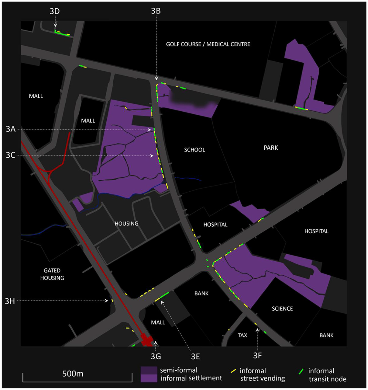
North Triangle, Manila – informal vending, transport and settlement.
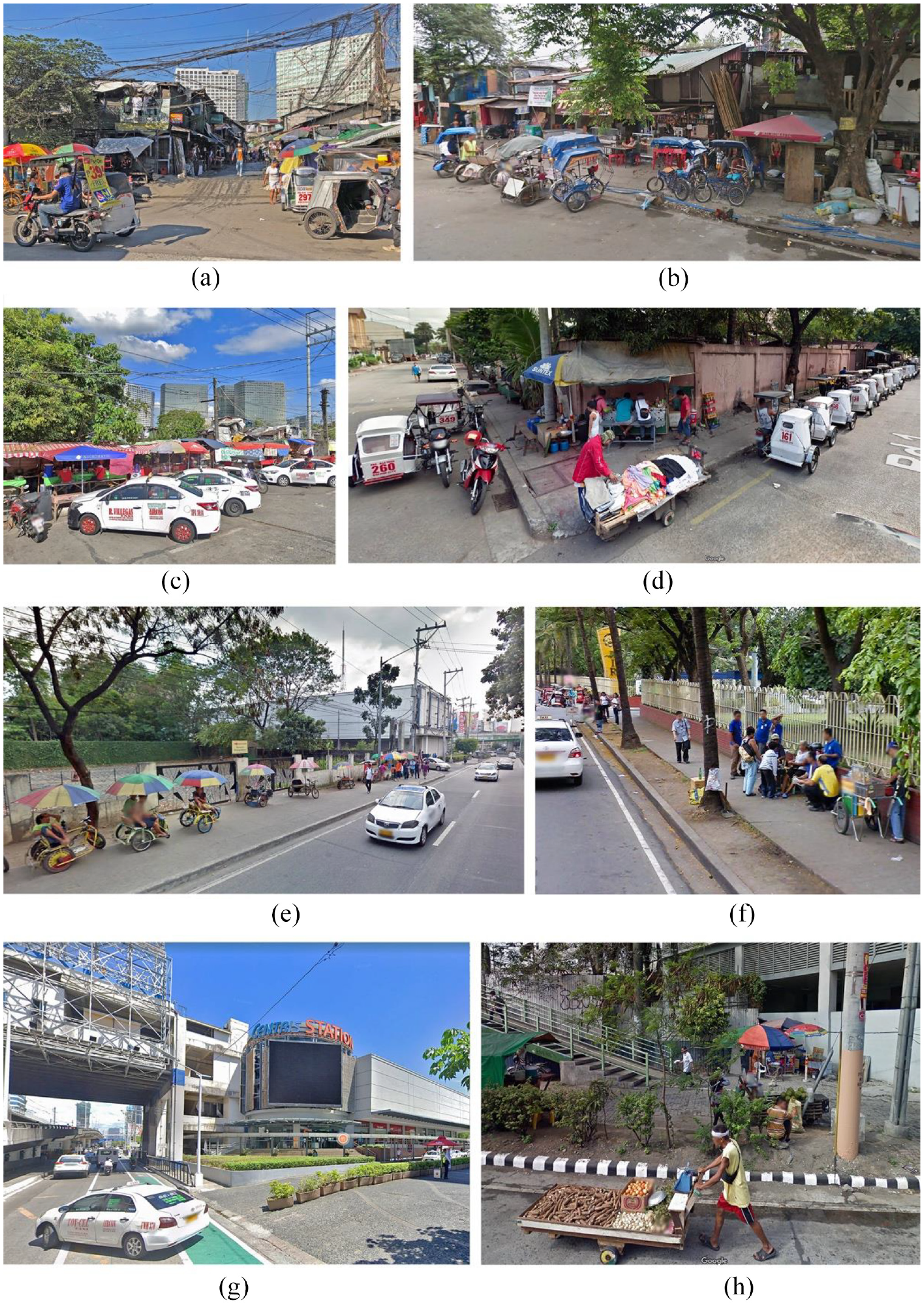
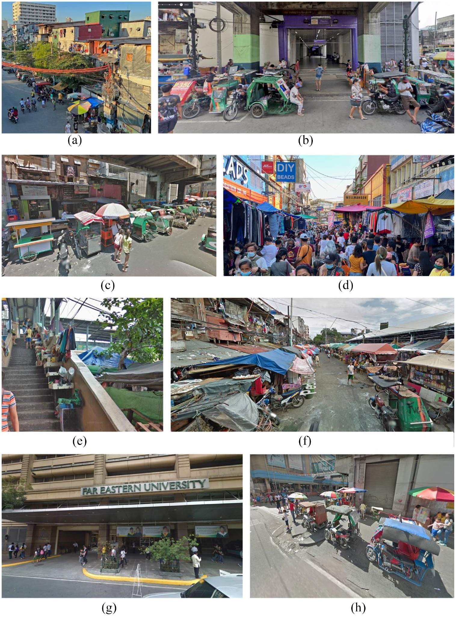
North Triangle – streetscapes.
The key spatial patterns of urban informality we find here are fourfold. First, all three modes co-locate along the interface between informal settlements and public streets – often broad pavements with space for vendors, tricycle parking and additional parking for other customers (Figure 3(A) and (B) – see locations on Figure 2). These are locations where vendors, who live in the settlement, can service a market that includes residents, tricycle/pedicab drivers and drive-by customers. The pedicab and tricycle drivers, who also live in the settlement, provide transport for residents and visitors to the settlements. These strips are also widely used by drivers of car-taxis to meet, eat and wait for jobs (3C). Thus there are several synergies operating between transport, street vending and settlement where each can service multiple markets, with overnight parking for vehicles and carts. The two large informal settlements also incorporate wet markets which serve a wider community, connected by both pedicabs and tricycles. Construction workers, students and formal taxi drivers are regular clients of these informal vending strips. Three of these settlement interfaces have been subject to partial demolition for road-widening over the last decade – in each case, the vending and transport activities have appropriated the new public space.
A second pattern evident is that both informal transport and street vending gather near the entrances to major formal zones or compounds. The transit node in Figure 3(D) is within a walkable distance from a highly formalised zone of malls, hotels and offices where all informal transport is excluded. One in the south is outside a mall entry (3E), while there are others near entries to the tax office (3F) and hospital. These clusters provide cheap transport and food to the workers within those enclaves, many of whom live in informal settlements. The main mass transit hub is the elevated rail station in the southwest (Figure 2) − here pedestrian flows are connected directly to the adjacent shopping mall and the informal trading and transport are kept at a distance (3G). The final pattern is that street vending also clusters around bottlenecks created by pedestrian overpasses across the major expressways (3H). This is a highly car-dominated landscape where fences prevent pedestrians from crossing the main roads. Thus informal modes of production both fill the gaps and take the opportunities that are created by formal planning processes which are primarily geared to middle-class and elite interests.
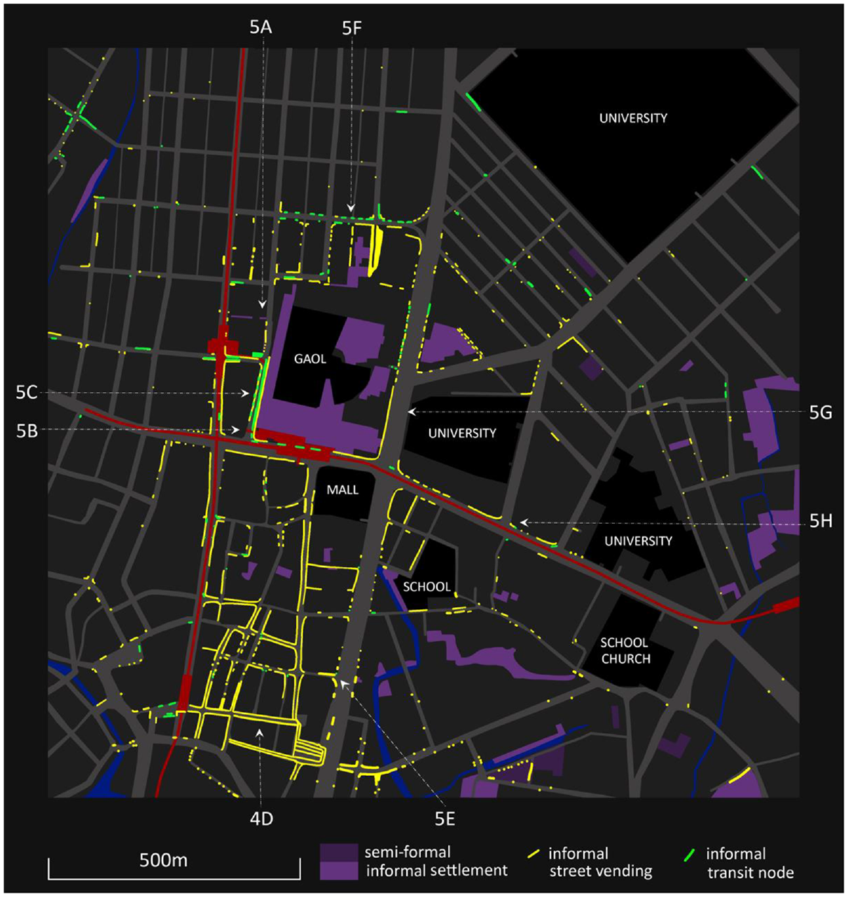
Recto/Quiapo, Manila
We now move to Recto/Quiapo in Manila (Figures 4 and 5), an older part of the inner city with much more intensive forms of urban informality (14°36′09.70″N 120°59′05.48″E). The small-grain and mixed-use Quiapo district to the south is an historic neighbourhood established in the 18th century under Spanish colonial rule when this was part of the old city centre. It is now the site of a vibrant street market, located between two north–south expressways and focused on the Quiapo Church and its adjacent plaza. Immediately to the north is the Old City Gaol, built in 1837, now overcrowded and controlled by gangs. It has long been surrounded by a very dense and highly informal settlement. Two major intersecting expressways adjacent to the prison have had elevated rail lines added, turning this into a major transit node known as Recto. To the north and northeast of the study area are mostly middle-class neighbourhoods, with a cluster of small university campuses that are collectively known as ‘U-belt’. Street vending saturates most streets around the transit hub and throughout the street market district to the south (Figure 5A). Pedicabs have been largely eliminated from this precinct, and tricycle taxis are the predominant mode of public transport for short trips. The large informal settlement has tricycle nodes and street vending along its public frontages which are also adjacent to the transit station entries (Figures 5B–C).
Recto/Quiapo, Manila – informal vending, transport and settlement.
Recto/Quiapo – streetscapes.
In the street market district to the south, it is often difficult to distinguish street vendors from the trading that extends from adjacent shops (Figure 5D). On market days, the vendors effectively block some of these streets and extend onto the adjacent expressways. Tricycles can only penetrate this pedestrian traffic very slowly, so most of the tricycle ranks are on the edges of the street market. Vendors are intensively focused around the bottlenecks formed by the overpasses and underpasses of the expressways, and they sometimes occupy these narrow passageways (Figure 5E). A wet market north of the prison is largely comprised of informal vendors adjacent to an informal settlement (Figure 5F) – a cluster of tricycle ranks on the nearby streets provides local connections. Figure 4 shows that the intensity of street vending generally diminishes with distance from the transit stations and markets, but intermittent vending and transport is evident in most streets throughout the district, where it concentrates on street corners.
Zones where informal modes do not occur include public streets near the university campus entries (Figure 5G) and middle-class streets. Vendors and transit nodes are often located across the street or around the corner from campus entries, where they are accessible for students and staff but do not interrupt the institutional image (Figure 5H). With a couple of exceptions, informal settlements are located along creeks and are invisible from the main streets. However, low-rent accommodation is mixed into many parts of this study area, with many ambiguities as settlements are renovated and formal buildings become informalised.
Tanah Abang, Jakarta
We now move to Jakarta, where we begin in the district with the most intensive street vending activity in the city (Figures 6 and 7). Tanah Abang is a network of bustling street markets located about a kilometre west of the main civic axis of Jalan Thamrin. This district has been the site of a market since 1735, when it was also a rural retreat for the colonial elite about 6 km south of the Dutch colony of Batavia (Wolthuys, 2020). It became the largest textile market in Southeast Asia and a site of considerable ethnic diversity, including many Chinese and Arab traders. Market buildings have been demolished and replaced several times, most recently in 2003 after a major fire when they were replaced by an 18-storey market complex with a mosque on top. This market is now connected via a number of street overpasses to several shopping malls and market buildings. This huge retail assemblage is connected to a major rail station along the edge of the Ciliwung river to the west. The informal street vending (Figure 6) mostly lines the edges of the main streets, with transit nodes on intersections. The street vending continues with less intensity in the backstreets, which are semi-regular grids of narrow lanes or semi-formal kampungs or urban villages (dark purple or grey). The most informalised kampungs (lighter purple or grey) line a small creek which is largely hidden deep within a network of narrow lanes. This broad area of intensive informality contrasts markedly with the highly formalised zone of hotels, housing, offices and shopping malls on the east and south-east. Despite being the location of rapid transit nodes (marked in red), all forms of informality are strictly excluded or kept at a distance (Figure 7A).
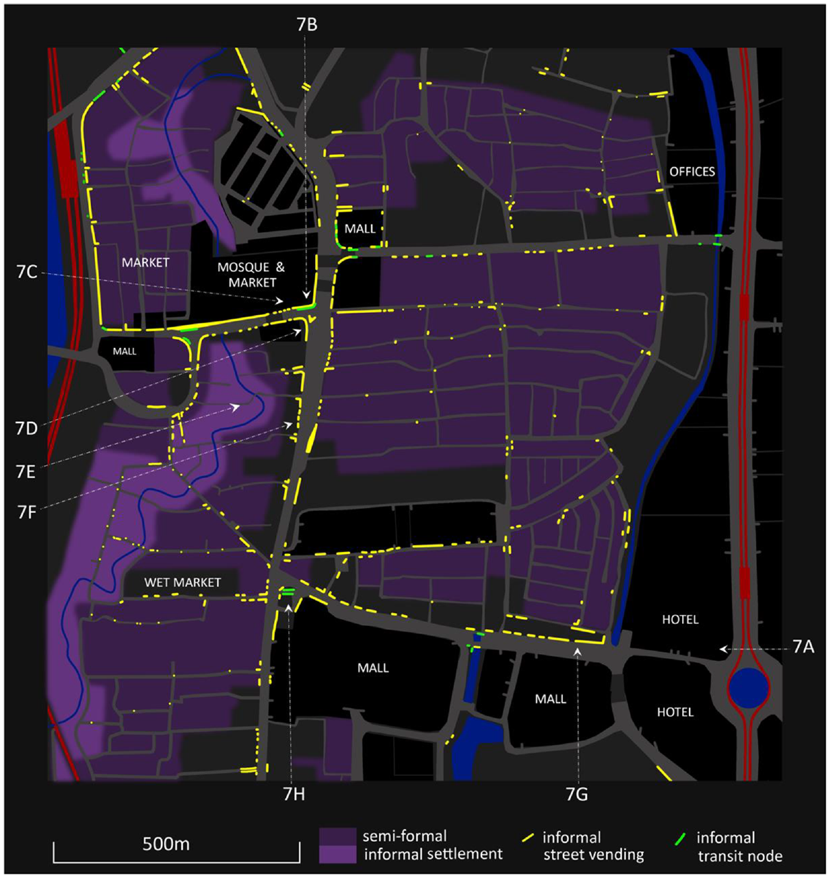
Tanah Abang, Jakarta – informal vending, transport and settlement.
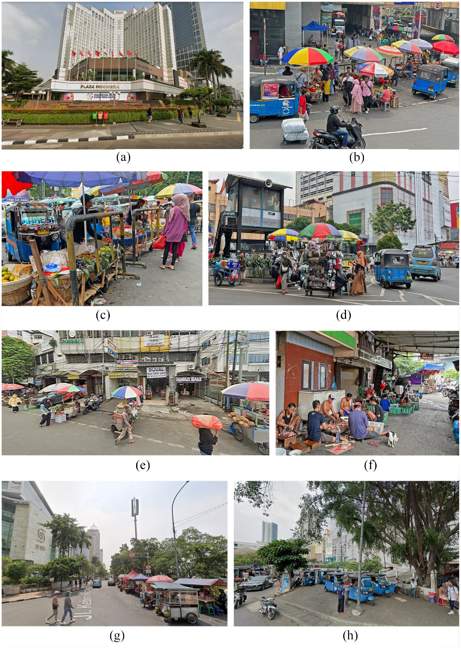
Tanah Abang – streetscapes.
The most intensive street vending extends almost continuously along the key access streets of Tanah Abang in the north-east of the study area. Many of these locations are at saturation levels, with vendors, pedestrians and vehicles competing intensively for the use of public space (Figure 7B). Here, the vending serves a broad metropolitan market and is heavily dependent on a full range of public transport. The blue tricycle taxis, locally known as bajajs, have a limited range and are formally banned from many major streets and expressways but are crucial for short trips. Motorcycle taxis (or gojeks) are more prevalent but get their trade from phone apps rather than pick-up zones. The informal tricycle nodes are mostly small slivers of space located between street vendors and moving traffic near key intersections (Figures 7C–D). The most intensive areas occupied by vendors and tricycles are subject to continuous police controls but are fluid – expanding, contracting and moving around within a similar area and never eradicated. While Street View shows evidence of occasional street clearances and the construction of police lookout posts on major intersections (Figure 7D), the general spatial patterns of vending and transport have not changed significantly. On the broader streets, trading expands and contracts with complex negotiated relations with adjacent proprietors (Figure 7E).
In the back streets and lanes of the kampungs, vending is intermittent and serves a local neighbourhood market. Here, most retailing is integrated with informal settlement through home-based enterprises and various forms of production that service the primary street markets (Figure 7F). The kampungs provide housing for those who run the street market, as well as the storage of vending carts and the production of goods. They are serviced by bajajs but there are no intensive taxi ranks.
A third form of street vending emerges along the southern border between the semi-formal zones and the strip of formal shopping malls (Figure 7G). The primary market here is the staff and customers of these malls, along with the hotels and offices along the civic boulevard where street vending is prohibited. Here, street vendors are arranged in semi-formalised strips across a broad roadway and co-located with a series of highly fluid tricycle nodes. At the western end of this strip, on the corner that connects this shopping mall district with the bustling street markets, is a major tricycle node which services both markets (Figure 7H).
Setiabudi, Jakarta
Setiabudi forms part of South Jakarta, where new commercial, residential and retail properties have developed as the city moved south during the Suharto era (Figures 8 and 9). The major north–south expressway through this site (Jalan Rasuna Said) was completed in 1979 and soon lined with office and embassy compounds. The morphogenic process was one of large grain formal development along the new expressway, with informal kampung development on agricultural land behind (Simatupang et al., 2015), incorporating a narrow river (Kali Cideng). These kampungs of Karet and Atas (to the west and east respectively) have a small grain morphology with a semi-regular street/lane grid that has emerged from earlier field boundaries. During the Suharto period of crony-capitalism in the 1990s, the kampungs lining the river were forcibly evicted and replaced with a formal development broadly known as Rasuna-Epicentrum. This has grown to encompass high-rise residential towers, office buildings and a shopping mall surrounding the river which is now a formalised canal and riverwalk. The displacement process has morphed into coercive eviction and continues in the northeast of the site (Leitner and Sheppard, 2018). This is not a gated community, but it embodies middle-class images and norms under tight private control (Kusno, 2010: 84). The landscape is manicured and relatively bereft of pedestrian life (Figure 9A). The more public expressway has eight lanes of traffic and broad pavements but no pedestrians, tricycles or street vendors (Figure 9B); it is lined with gated and guarded compounds of 3–5 ha each.
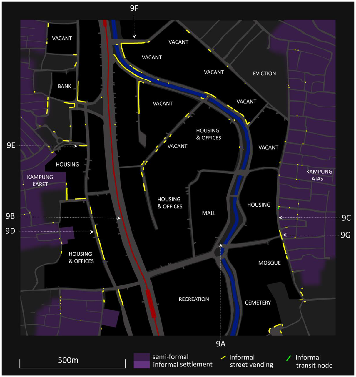
Setiabudi/Atas, Jakarta – informal vending, transport and settlement.
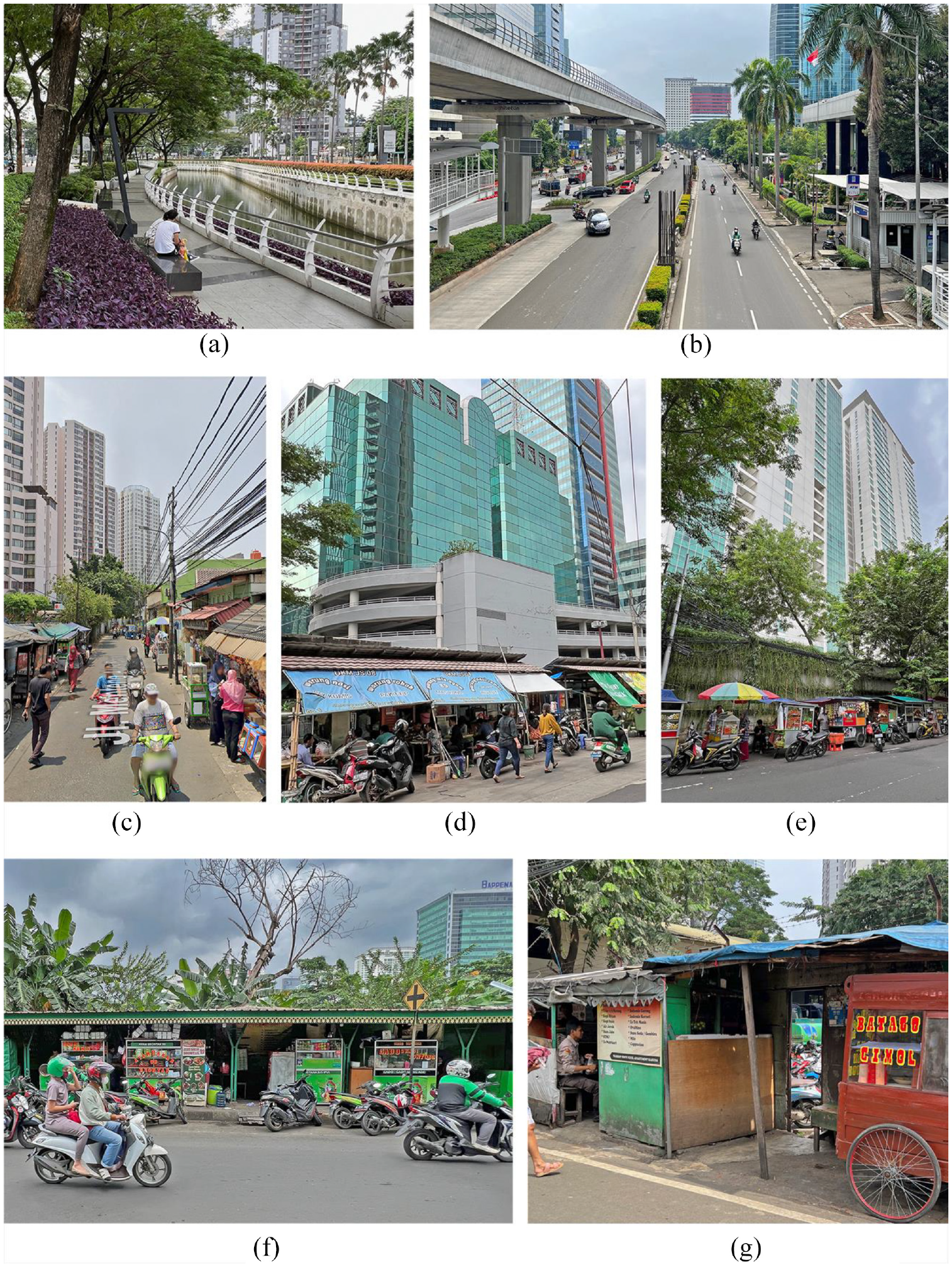
Setiabudi/Atas – streetscapes.
Kampungs Atas and Karet to the east and west sit immediately adjacent to these formal compounds, often separated only by a high wall (Figures 9C, E). They are the key source of cheap labour for the various formal projects and have also been transformed by them. Recent studies have shown sharp increases in rent, displacement of local populations and conversion of housing to cheap rental accommodation (Simatupang et al., 2015). While the formal compounds are free of vendors, forms of street vending have infiltrated along the edges and in the interstices of this broad zone of exclusion, under conditions where they are either hidden or semi-formalised. These vendors are nearly all in strips that form a pattern of lining the external blank walls of compounds at least one block back from the main expressway and are invisible from the key formalised zones (Figures 9D–E). Street View data shows a process of increasing formalisation of these vending strips since about 2015. The most formalised strips enclose the vendors within a formal shelter designed and provided by authorities, together with a governance regime defining the territories, products and hours of trading (Figure 9F). These vendor strips tend to service the office workers from compounds lining the expressway and most do not function on weekends. More informal strips are found in less visible or more distant locations. Some large compound sites have been cleared but held vacant for the next round of formal development, and the edges of these areas provide temporary locations for vendor strips (Figure 8).
While bajajs (tricycles) have access to the kampungs (where many of the drivers live) and play an important role in providing local connections to the broader city, the formalised zone is an impermeable barrier from which they are entirely excluded. The key public transport modes are motorcycle and car-taxis whose drivers are also an important market for the out-of-sight vendor strips.
There is some further street vending within the kampungs, but public space is scarce and vendors are often a mobile supplement to home-based enterprises. Vendors do flourish, however, wherever space is available near the entry points to the formal zone. This is most apparent at the boundary where a concrete wall divides Kampung Atas from the formalised zone with a single half-metre-wide hole in the wall which mediates all traffic between the two zones (Figure 9G). This entry is sized to allow pedestrian traffic while preventing access for vendor carts. It provides kampung residents access to formal jobs, as well as giving employees within the compound access to cheap shopping from street vendors who line this edge of Kampung Atas (Simatupang et al., 2015).
The ironic spatial logic here is that the street vending patterns have been generated by the particular forms of privatised neoliberal development that seek to exclude them. Where the large walled compounds turn a blank wall to a back street, this becomes a vending strip. These strips are then formalised as part of a street cleansing regime, or they adapt to become self-formalised for their own survival. The broad pattern here is a very divided landscape of formal compounds and informal kampungs that service them.
Inventraset assemblages
The four study areas introduced here are each windows onto different examples of spatial interrelations between informal street vending, transport and settlement, and between each of these and the more formal city. While often difficult to measure and analyse, there is a logic of spatial synergies that begins to emerge. To summarise this logic diagrammatically, we suggest a triangle represented by the dark arrows in Figure 10 where settlement, vending and transport provide affordable housing, shopping and mobility respectively. Informal settlement produces affordable housing for street vendors with walkable access to vendor markets, overnight parking for carts and storage of goods. The goods that are sold on the streets are often produced or prepared in the settlements and provide a source of cheap food and products for the residents. Wherever settlements have a public interface, this often becomes a street vending location that serves a larger market. Informal settlement is also geared to informal transport, providing affordable housing for drivers, parking for vehicles and mobility for residents. Street vending and informal transport are both attracted to existing pedestrian flows within the city – bottlenecks, transit nodes, intersections – and often compete for the same public spaces. Customers and vendors both need cheap transport to and from the street markets. Street vendors are the source of food, drink and social venues for informal drivers, who also provide cheap access to vending locations. These alliances often transcend their economic functions to incorporate the social and political; the vending spaces and tricycle nodes on the edges of settlements are meeting spaces for community-based and industry-based organisations which are crucial actors in the struggles to resist eviction and secure sustainable tenure and governance.
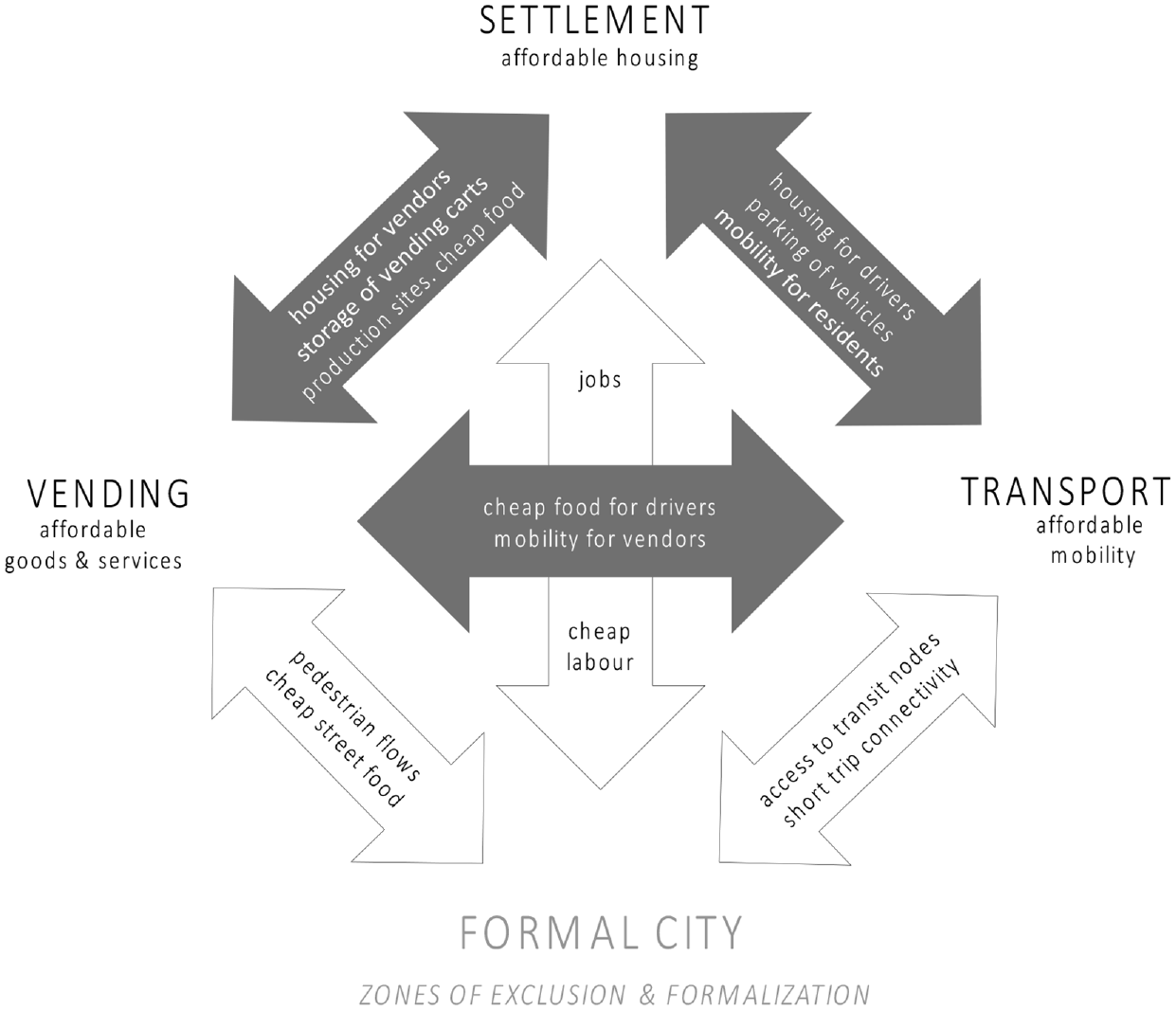
Inventraset assemblages.
This is what we call the ‘inventraset triangle’, which is in turn part of a larger assemblage of interconnections with the markets and jobs of the more formal city – represented by the white arrows. This is the means through which populations of urban poor gain a foothold and sustain livelihoods in the city. Informal urbanism provides cheap labour for formal jobs in transport, construction, domestic work, security, shop assistance, cleaning and so on. Informal public transport fills the mobility gaps of last-kilometre connections as street vending fills the gaps in retail markets – both servicing middle-class customers and sustaining an otherwise dysfunctional formal system. Thus, informal urbanism becomes insinuated into the more formal city, where it engages with modes of formal governance and urban planning. Rather than eradication or any form of blanket control, what we find are unevenly enforced zones of exclusion and formalisation that are applied to all three modes of informal production. While informal settlement is illegal in all zones, eviction is largely limited to sites that have been selected for formal redevelopment, road widening and/or urban cleansing – linked to the production or expansion of zones of formalisation. Despite formal policies of eradication, the more formal parts of the city have a deep and existential dependence on informal vending, transport and settlement.
We are not suggesting that the complexities of informal urbanism can be reduced to the diagram in Figure 10, only that this can be a useful framework within which to investigate. The diagram has a particular role in assemblage thinking where it enables us to show the productive relations of an assemblage in abstract form − a diagram is an ‘abstract machine’ (Deleuze and Guattari, 1987: 141–148). While we have focused here on the synergies between the different parts, there are of course tensions, frictions and forms of disintegration between them. The tensions between modes of informality are generally easily resolved by the agility and flexibility of different actors on the ground. The most noticeable tensions and disruptions are generated by shop owners and street-level bureaucrats, or by the state through evictions, exclusionary zoning and selective formalisation.
Inclusion and exclusion
The spatial logic that emerges here is not singular; we find at least two fundamentally different ways in which the inventraset triangle is geared to the more formal city. On the one hand, we have the highly complex street markets, transit nodes and settlement interfaces, where the informal is normal. On the other hand, we have extensive exclusion zones where informality is marginalised, hidden or camouflaged, where the formal is an illusion. Binary thinking might cast these as the ‘informal city’ and the ‘formal city’, but this is not a binary division, nor a continuum. As we have seen, these zones of ‘inclusion’ and ‘exclusion’ are interconnected zones within the same city, but they are also modes of production and informal/formal assemblages. We now explore this distinction through a set of four different but overlapping lenses –capital, governance, morphology and image.
First, Braudel (1979) makes a distinction between ‘markets’ and ‘capitalism’, where a market is a zone of economic activity strongly geared to the everyday life that it sustains and capitalism is the organised extraction of profit from those markets (Wallerstein, 1991). For Braudel, markets are defined by competition and transparency, and capitalism is anti-market in the sense that it seeks monopoly control. Markets are self-organised informal networks which capitalism formalises into tree-like hierarchies; capitalism is organised to extract profit from self-organised production. While the neoliberal city is market-based by definition and capitalism penetrates the informal street markets, this distinction between markets and capitalism can help us understand the spatial logic of this distinction between the complex self-organised networks of inclusion and formalised hierarchies of exclusion.
Second, governance within the integrated assemblage is fluid, negotiated, contested, supple, provisional and periodic, while in the exclusion zones it is strictly codified to produce a rigid and regimented order. While formal rules are in place for all modes of production, in the inclusive zones they are loosely or selectively enforced. In the zones of exclusion, governance is strict and often private. In the inclusive zones, governance is largely negotiated by street-level bureaucrats – a cat-and-mouse game where petty fines and bribes are part of the normal cost of doing business (Recio, 2021). We note an ‘extra-step’ rule where formal regulations are regularly transgressed by an extra step (Dovey et al., 2023). If a boundary is established, vendors will transgress it by up to a metre. If tricycles have a restricted range, they will overstep it by an extra block or two. A good deal of informal settlement is in the form of an extra room added to a formal building.
Third, the more inclusive districts are generally identified by an urban morphology of small-grain, low-rise buildings with high land coverage and mixed functions. Zones of exclusion are more often high rise with low coverage on large-grain compounds with separated functions. Inclusive districts are generally characterised by walkable connections in contrast to the car-dependent and privatised compounds. While the interiors of exclusive compounds are generally walkable, the compound boundaries produce impermeability and immobility at the larger urban scale. Exclusion produces spatial hierarchies rather than walkable networks; higher building densities but lower street life and population densities.
Finally, there are important differences of image and visibility. Inclusive urbanism is messy, the urban image is emergent and transparent, the transactions of urban life are visible and little is hidden (Figures 3A–C, 5B–F, 7B–E). In the exclusion zones, the urban image is curated and cleansed to produce both publicly and privately branded spaces (Figures 5G, 7A, 9A–B). Public branding produces symbolic capital that translates into political capital as signifiers of law and order. Private branding operates within enclaves and enables middle classes and elites to escape the informalities of the street. Such public and private branding together construct and sustain the illusion of a clean, green, modern and orderly city. The pervasive informality of the city is incorporated yet rendered invisible by deploying design morphologies of exclusion, sustained by strict governance. Issues of brand image, visibility and aesthetics are powerfully linked to practices of social exclusion but are relatively under-researched (Dovey and King, 2011); eviction is often legitimated as ‘beautification’ with broad community support (Harms, 2012).
Having sketched this distinction, we return to the non-binary nature of relations between the formal and informal and the interdependencies of Figure 10. Exclusive zones are secured and sustained by those who have been excluded; whose livelihoods are sustained in turn by the jobs along with the cheap food, transport and housing. The inventraset triangle, with all its problems, is the solution to this problem. The exclusions cannot be total or the mode of production would collapse. Zones of inclusion and exclusion overlap and intersect to produce streets where informality seeks to look formal without necessarily becoming formal (Figures 3D–G, 5E, 7G–H, 9D–E). The image of the well-planned city is almost achieved while maintaining livelihoods and informal production. Vendors and drivers may self-organise to line up their carts and vehicles in rows within the constraints of the extra-step rule. The street facades of informal settlements are more formalised than the deeper laneways. Informality is tolerated if neatness is maintained. These ‘between zones’– where the formal is becoming informalised and the informal is becoming formalised – are crucial zones of becoming, spaces of negotiation and possibility.
Conclusion
While our intention is to initiate rather than conclude discussion, we reiterate some key contributions of this article. First, we suggest the ‘inventraset’ framework as a research agenda and conceptual vocabulary that moves beyond the study of vending, transport or settlement to engage with crucial interrelations between them and how they are geared to the formal. We develop survey, mapping and analysis methods within an assemblage framework to investigate complex urban conditions on the ground in highly informalised cities where reliable data are unavailable − the maps are not illustrations but data, designed to show a spatial logic. This work also moves beyond conceptions of informal urbanism as the inverse of the formal, to develop knowledge about informality-in-itself. The patterns of interrelations, synergies, flows and rhythms that we have begun to sketch here are understood by the different actors who engage with them in everyday life – primarily vendors, residents, drivers, customers and street-level bureaucrats – but this local knowledge about informal urbanism rarely penetrates the planning system. While it is understood that livelihoods are geared to locations, there is little understanding of how this actually works on the ground in relation to settlement and transport; thus, sympathetic officials are not positioned to negotiate sustainable outcomes.
Highly informalised cities like Manila and Jakarta are not ideal but are not improved by having elite ideals imposed upon them. The challenge is to produce empirically informed concepts with a capacity to change both theory and practice at multiple scales from the global to the streetscape. A focus on spatiality and morphology is crucial because the design and governance of public space are two key levers of control; most attempts to eradicate, contain or formalise informal modes of production involve a spatial fix – the use of walls, fences, street clearances, evictions, demolitions, territories and entry protocols. The problem is not that the state engages with these issues but that it does so in ignorance of the ways that informality sustains livelihoods, and the ways that formalisation sustains inequity. The extraordinary amounts of capital devoted to producing and maintaining illusions of formality, of hiding informal production, suggest that this spatial logic is a primary means through which inequalities are reproduced. The clean, green and formal city maintained within the zones of exclusion is a cruel fiction which hides the backstage of informal production and exploitation, while also producing an impermeable and unwalkable urban morphology. As we understand informal urbanism better, there will be a case for demolishing walls instead of settlements, for activating streets instead of clearing them.
This article shows something of how informal urbanism works to produce spatial outcomes at urban design scales in particular districts of particular cities. The degree to which we might learn more general or global lessons from this is an open question. While urban informality is a global challenge, enmeshed in issues of inequality and climate change (Finn and Cobbinah, 2023), it cannot be simply reduced to global theory of any kind without a better knowledge base of how it works on the ground. Rather than baulk in the face of what seems to be a ‘radical unknowability’ (Simone and Castán Broto, 2022), the challenge is to enter into the complexities of urban informalities as they invent, transgress and settle into cities of the global South. We will do well to approach this task from multiple points of view − capital, governance, morphology, image and there will be others − and avoid any easy reduction to singular explanation. What is at stake here beyond academic debate is more effective forms of knowledge about the ways that livelihoods of the poor gain a foothold in these cities. If and where formalisation is desirable, then it must be undertaken with a good understanding of the impact on livelihoods. Any blanket imposition of a binary distinction between formal and informal as legal and illegal – the idea that informality must be erased because it is illegal – will damage livelihoods. What is also at stake is the productivity, creativity and adaptability of the city more generally. Informal urbanism is a mode of production that depends in large part on the inventiveness and transgression of inventraset assemblages.
Footnotes
Acknowledgements
We acknowledge the work of Elek Pafka, who co-authored an earlier study of street vending in Manila on which this study draws (Dovey et al., 2022); we also thank Merrick Morley for help with the maps.
Declaration of conflicting interests
The author(s) declared no potential conflicts of interest with respect to the research, authorship, and/or publication of this article.
Funding
The author(s) received no financial support for the research, authorship, and/or publication of this article.