
Abstract
This paper capitalizes on the opening of Bogotá’s first urban gondola, locally known as TransMiCable, to examine the socially embedded character that shapes the adaptation of informal transportation markets to urban change. Drawing on GPS-assisted route mapping techniques, field observations, and semi-structured interviews with community leaders, informal transportation providers, and planners, findings reveal that the informal transportation market expanded following the opening of TransMiCable. New route associations were formed to connect the sprawling periphery with TransMiCable, and others reoriented their service toward the project. These adaptations were shaped by a complex interplay of social dynamics, including negotiations involving informal transportation, cooperative heads, neighborhood organizations, and the state, as well as a historical process of informal land development that continues to push the urban fringe outward. While informal transportation undeniably fills service gaps left by conventional public transit, as other scholars have long argued, this study underscores the social dynamics that, together with peripheral urbanization processes, shape how these markets emerge, adapt, and persist in cities in the Global South.
Introduction
Often referred to as informal transport, paratransit, or more recently popular transportation, these services serve a large share of low-income urban residents in the Global South. Scholars have long argued that such services emerge where state-planned public transit is lacking or unreliable, filling critical service gaps (Alcorn and Karner, 2021; Behrens et al., 2015; Cervero and Golub, 2007). Several cities have invested in large-scale, capital-intensive public transit projects, with many expecting informal transportation to be absorbed, replaced, or displaced into other markets (Behrens et al., 2015; Paget-Seekins et al., 2015; Salazar Ferro et al., 2013). Others advocate for an incremental planning approach, while recognizing the social and political dimensions that govern informal transportation markets (Klopp, 2021; Mittal, 2022; Rekhviashvili and Sgibnev, 2020). This paper capitalizes on the opening of Bogotá’s first urban gondola to examine the socially embedded character that shapes the adaptation of informal transportation markets to urban change.
The combination of rapid urbanization, rising residential land values, and limited affordable housing options often forces low-income households to settle in difficult-to-access, self-built neighborhoods that frequently fall outside planning regulations in cities in the Global South. Frequently referred to as slums, barrios informales, or favelas, these settlements are often characterized by complex networks of narrow winding roads, making traditional bus operations challenging and economically unfeasible. These conditions are considered fertile ground for informal transportation to emerge (Cervero and Golub, 2007; Salazar Ferro et al., 2013).
Over the past two decades, however, a handful of cities in the Global South have invested in cable-propelled transit, colloquially known as urban gondolas or aerial cable cars, to address the mobility challenges these historically marginalized areas have faced. Bogotá opened its first urban gondola, locally known as TransMiCable, in December 2018 (Figure 1).
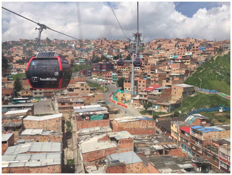
View of Ciudad Bolívar from aboard TransMiCable.
Serving one of the poorest districts in the city, which originated from illegal land subdivisions in the 1950s (Zorro, 2016), TransMiCable is part of a new generation of municipal programs aimed at physically upgrading informal settlements (Brand and Dávila, 2011). Housing approximately 700,000 residents, Ciudad Bolívar is also known for its presence of informal transportation services (Brand, 2018). The aerial cable line spans 3.34 km with four stations, including one integrated with the city’s renowned Bus Rapid Transit system.
The potential disruptive effects of TransMiCable on the informal transportation market in Ciudad Bolívar represent a timely opportunity to examine one fundamental question: what are the dominant social dimensions that shape adaptation of informal transportation to urban change? These dimensions are studied using a mixed-methods research design consisting primarily of semi-structured interviews, GPS data, and field observations.
Findings reveal that the informal transportation market expanded following the opening of TransMiCable. Insights from interviews with community leaders also revealed key social forces and informal land markets that contribute to understanding the growth of informal transportation, highlighting how neighborhood organizations, informal transportation cooperative members, and informal urbanization patterns shape the changes that follow state-led interventions in the Global South.
Theoretical and empirical background
Cervero (2000) provides a global portrait of informal transportation. Based on empirical evidence collected from cities worldwide in the 1990s, this work describes the informal transportation sector economy, underscoring the market dynamics in which it operates. Since then, several dozen academic articles and books have been published that describe informal transportation markets and actors worldwide. Broadly divided into two large bodies of literature, these works are briefly summarized next.
Informal transportation: On vehicles, logistics, and service gaps
Rooted in classical economics, the broader academic literature on informal transportation has emphasized its role in filling service gaps left by state-planned, hence formal, public transit systems. Notable publications include Cervero and Golub (2007), Behrens et al. (2015), and Ehebrecht et al. (2018). Studies in this tradition conceptualize informal transportation as a rational response to a laissez-faire environment in the provision of passenger transportation services where state-sanctioned transit is nonexistent or, at best, precarious. These works typically focus on the supply side of the informal transportation market, documenting operational characteristics—from vehicle and route features to fare and business structures.
The flexibility of informal transportation and the laissez-faire environment in which these services often operate also come at a cost for society. With little to no state intervention in the informal transportation sector and low profit margins, some observers note that drivers often aggressively compete for passengers, resulting in increased congestion and unsafe road conditions (Cervero, 2000; Cervero and Golub, 2007). The negative consequences associated with informal transportation operations have prompted local governments to intervene, often by investing in more and better public transit infrastructure (Asimeng and Heinrichs, 2021; Paget-Seekins et al., 2015).
The emergence of new technologies expanded the potential for scholars to study the physical attributes of informal transportation through GIS tools, challenging the characterization of this sector as unplanned and chaotic. The Digital Matatu Project pioneered the use of smartphone GPS technology to collect and map data on informal transit routes in Nairobi, revealing a previously hidden order in the city’s informal transportation system (Williams et al., 2015). Similar informal transportation mapping initiatives have been undertaken in other African cities and more recently in Latin America (Klopp and Cavoli, 2019; Mittal et al., 2024; Vergel-Tovar et al., 2022).
Although there is limited evidence on how informal transportation systems respond to improvements in public transit infrastructure, and overall urban change, some research offers insights into their adaptation to urbanization dynamics in the Global South. For instance, Gamble and Puga (2019) found that informal transportation routes in Quito tend to follow the city’s fastest-growing peripheries, where many low-income residents live. These peripheral neighborhoods of informal origin have recently been formalized, typically through the issuance of land titles and the provision of basic infrastructure, but with little to no intervention in public transit. This evidence suggests a potential causal link between neighborhood development and the emergence of informal transportation services (Cervero, 2013; Salazar Ferro et al., 2013).
Cities in the Global South have historically expanded through a process that pushes the urban fringe outward, potentially opening new service gaps for informal transportation to fill. Caldeira’s (2017) theory of peripheral urbanization captures this dynamic, describing how peripheries consolidate incrementally through residents’ efforts and selective state intervention, only to become less affordable over time. This cycle reproduces urban growth on ever more distant fringes where land is cheaper, and enforcement of land-use regulation is low or nonexistent.
Scholarship focused on these expressions of informality has further underscored how economically disadvantaged populations collectively shape these spaces through insurgent planning practices, sometimes in contestation with the state and sometimes in complicity (Gilbert and Ward, 1984; Miraftab, 2009; Roy, 2005). However, while this body of work highlights the social dynamics and actors involved in the production of peripheral urbanization, it rarely engages with the role of informal transportation in shaping the urban periphery.
Informal transportation as a socially embedded market
Challenging the broader body of scholarship that emphasizes operational characteristics and network gaps, an emerging group of scholars focuses on the processes, actors, and institutions behind informal transportation markets. For Mittal (2022), whilst dominant scholarship, driven by economic and engineering traditions, acknowledges the critical role of informal transportation in service provision across the world, it consistently marginalizes the actors and political forces crucial to understanding how informalities are produced, in which the state is a central pivot. Rekhviashvili and Sgibnev (2020) similarly contend that in informal transportation markets, economic exchanges do not exist in an abstract form, calling for a critical engagement with the sector’s socially embedded character.
Recent studies that underscore the socially embedded character of informal transportation reveal how new routes are formed. For instance, Kerzhner (2024) tested how informal transportation markets respond to temporary operational subsidies in an unserved area of Kampala. Using a combination of GIS and qualitative methods, this study reveals that, on the one hand, establishing new services can be challenging, requiring route organizations to have the necessary capacity and appetite for risk. On the other hand, when such investments are made, other formal and informal actors, such as police, government bureaucracy, and competing operators, can act to extract the gains, slowing potential market growth. This evidence is consistent with other studies that challenge the notion that informal transportation is flexible, demand-responsive, and purely profit-motivated (Heinrichs et al., 2017; Kerzhner, 2022).
Other studies that resonate with the notion of social embeddedness focus on the types of knowledge and processes behind informal transportation adaptation to neighborhood change. Goldwyn (2020) found that the Dollar Van routes in Brooklyn are far from reactive or improvised. According to the author, these operators engage in a planning process that relies on local knowledge of land uses and demographic changes, acquired from their passengers and everyday observations—a planning practice referred to as “generative” planning by Uzzell (1987).
Such valuable knowledge—from devising routes, stops, fares, and other key features—Klopp (2021) argues, underscores that informal transportation sector actors are de facto planners and that their knowledge should be taken seriously in planning processes. Currently, however, transportation planning practice does not focus on leveraging such knowledge but instead focuses on prescribing the replacement or integration of these services with centrally planned public transportation (Alcorn and Karner, 2021; Salazar Ferro et al., 2013).
This paper contributes to the large body of research on informal transportation, briefly summarized in this section, in two ways. First, by combining innovative data collection and analysis methods, this paper sheds light on how the sector adapts to urban change in the context of Bogotá’s TransMiCable project. Second, by focusing on the socially embedded character of informal transportation, the paper highlights the role of key actors, knowledge, institutions, and power dynamics that, once studied together, provide a more complex picture of how this transportation market grows in tandem with the urban periphery—and despite the state providing better public transit.
Research design
Because the local government considers informal transportation to be demand-responsive, flexible, and, more importantly, illegal in Bogotá, there is little official data available on these services. For this reason, and given the nature of the questions that motivate this paper, a mixed-methods research design comprising GPS-assisted route-mapping techniques, semi-structured interviews with key stakeholders, and field observations was employed. More details of each method are described next.
Establishing the baseline
During the six months preceding the opening of TransMiCable, informal transportation services available were mapped. The initial focus was on services within the project’s catchment area, defined in official documents as the 800 m buffer around its three stations. This threshold is commonly accepted in transit planning to represent the distance most people are willing to walk to access fixed-guided transit (O’Sullivan and Morrall, 1996) and has also been shown to be a strong predictor of ridership (Guerra et al., 2012). To prepare for a safe and efficient mapping effort, background information on Ciudad Bolívar’s informal transportation system was gathered through several visits to the research site spanning four months.
After identifying and digitizing each route’s terminal points, all informal transportation services available months prior to TransMiCable’s opening were mapped using GPS-assisted mobile data collection methods. All available informal transportation vehicles within the project’s catchment area were ridden, while passively collecting geospatial data using the Open GPS Tracker (OGT) mobile application for Android phones. The application generated digital traces in GPX format, recording geolocated timestamps at 30 second intervals. The collected GPS traces were subsequently cleaned and processed using QGIS to produce clean maps depicting route layouts and their overlap with TransMiCable’s catchment area.
In addition to route geometry, operational characteristics—including service frequency, stop locations, and vehicle types— were documented through field observations and, where feasible, confirmed by passengers and business owners in the area. This information was recorded in route-specific metadata files to support subsequent qualitative data analyses upon returning to the field once TransMiCable opened to the public.
Understanding adaptation responses and social dynamics
Once a physical characterization of informal transportation services and the research site was established, a second stage of fieldwork was conducted six months after TransMiCable opened to the public, and it continued for another four months. This stage involved in-depth semi-structured interviews with key stakeholders to gain insights into the planning processes and adaptation strategies of informal transportation providers to urban change. It also involved digitalizing any observable changes in the informal transportation network using the same methods used to establish the baseline.
Interview guides structured conversations around topics including knowledge about informal transportation in the district, traditional operational characteristics, social networks, key actors involved in route planning and operations, and adaptation processes associated with the arrival of TransMiCable and other historical moments of neighborhood formation and change. A total of 31 interviews were conducted with participants from three main groups: transportation planners, neighborhood association members, and informal transportation providers.
Most transportation planners interviewed were part of the city’s two public transportation agencies, and one worked as a route logistics and planning coordinator with the private concessionary operating the state-sanctioned bus system in Ciudad Bolívar. Community members included associates of various neighborhood organizations, including current and former leaders, secretaries, and treasurers. Informal transportation providers consisted primarily of vehicle owners, who were usually drivers, as well as some dispatchers and heads of route associations or cooperatives.
Participants were recruited through a combination of convenience and snowball sampling. Initial participants consisted of transportation planners, who then referred other transportation professionals with knowledge of the district, as well as contacts in neighborhood organizations. According to planners and researchers also working on Ciudad Bolívar, grassroots neighborhood group leaders are not only community gatekeepers but also trusted by informal transportation operators, thus constituting the natural point of departure for this second fieldwork phase. Transportation planners also provided contacts for neighborhood organization representatives, who in turn referred informal transportation providers ranging from cooperative members to route operators and investors.
Many informal transportation providers agreed to participate because recruitment occurred through trusted intermediaries. In several cases, interviews with drivers were conducted while they were covering their routes, eliciting responses directly linked to the places they traversed and the actors and social dynamics associated with them. Many interviewees confirmed and expanded upon field observations and data analyses.
All interviews were conducted in Spanish. Interview recordings and transcripts were then coded and analyzed using the qualitative data analysis software MAXQDA and flexible coding methods (Deterding and Waters, 2021). The flexible coding method began with keywords from the interview topic guide, and additional codes were added as topics emerged during the analysis. Topics were triangulated with insights from GPS traces, which depicted changes in the services provided. These were further augmented with satellite images from Google Earth and Bogota’s OpenData website, capturing informal urbanization patterns in the periphery of Ciudad Bolívar, as well as additional field observations deemed necessary as more information was collected and analyzed.
Topics generated during the coding process were used to organize and retrieve information that supported the identification of key themes, which structured the next section. Together, these provide a more nuanced account of how informal transportation emerges and adapts to the evolving urban periphery—including, in this case, the investment in TransMiCable—while underscoring its socially embedded character.
Findings and discussion
Four overarching themes structure this section. The first examines the supply side, focusing on route layouts and operational features that contextualize the informal transportation market prior to TransMiCable. Building on this foundation, the second highlights the diverse service gaps that informal transportation fills in the area. The third section examines the market’s changes following the launch of TransMiCable, focusing on its expansion, new route-planning practices, and power dynamics and territorial negotiations. The fourth explores the linkages between peripheral urbanization and network expansion, highlighting linkages among route-planning processes, grassroots organizations, and neighborhood formation and formalization processes.
Informal transportation market supply: A baseline
Prior to TransMiCable’s launch, Bogotá’s public officials had little information about the presence or functioning of informal transportation services in Ciudad Bolívar. No systematic monitoring was in place, and there were no reliable records on ridership, routes, operators, or fleet characteristics. A 2005 study commissioned by the city identified only two routes in the area, demonstrating the extent to which this sector remained poorly understood by planning professionals in 2017 when fieldwork for this study began.
Consistent with findings from other cities in the Global South, while vehicle size and route design varied considerably, the system exhibited high levels of organization— enough to allow systematic mapping of routes, terminals, and service patterns. A total of 10 distinct informal transportation routes were identified and mapped (Figure 2). All routes had dedicated terminals, typically located near key commercial areas. In all cases, passenger pick-ups and drop-offs were often arranged upon request, offering sufficient flexibility to minimize walking distances. Collectively, these served about two dozen low-income neighborhoods.
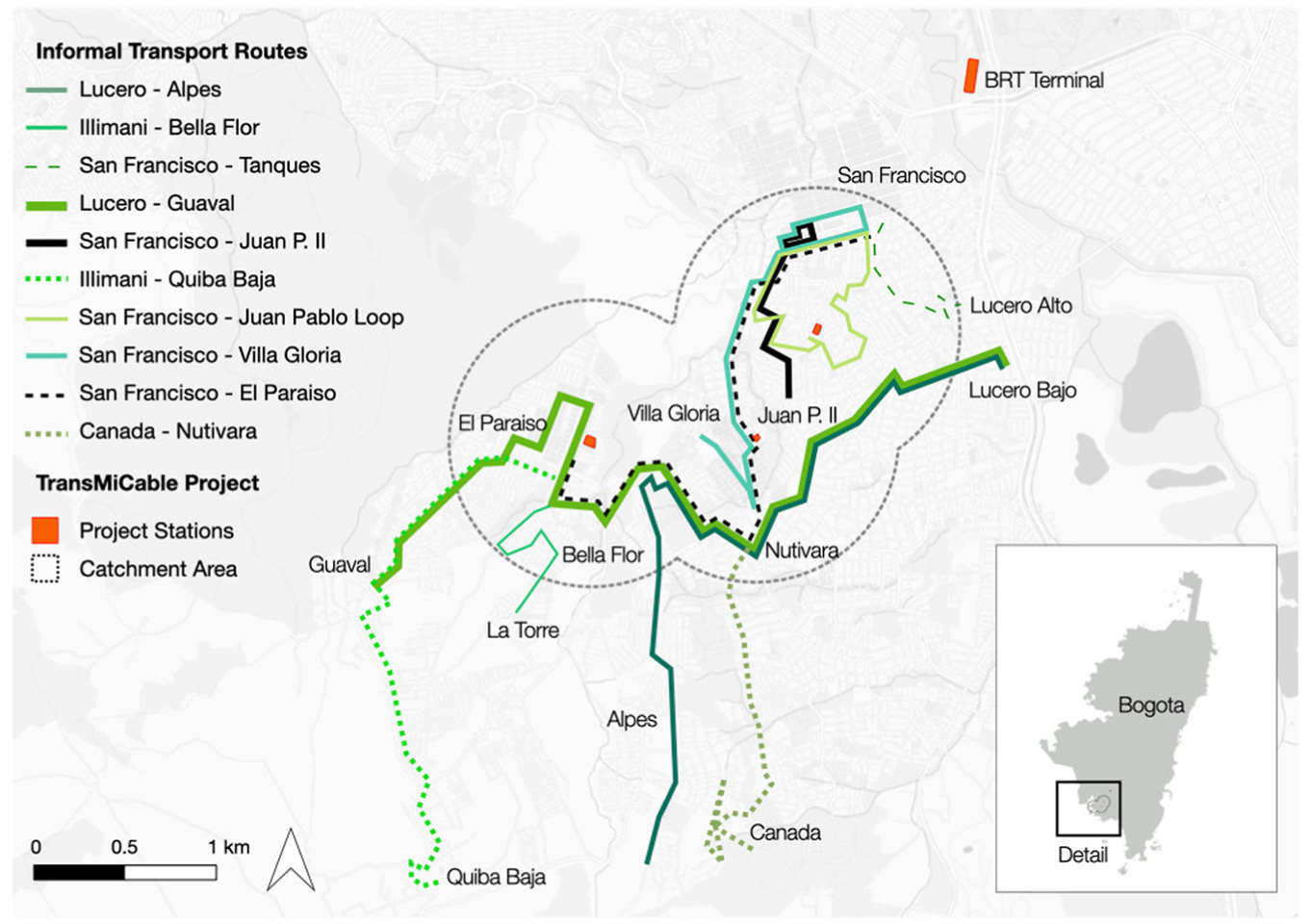
Informal transportation market prior to TransMiCable.
Some routes exhibited a remarkable organizational consistency, resembling centrally planned bus services. Two, operated by a long-standing cooperative, used 12-seater vans, locally known as “páneles,” departing every seven minutes from a terminal in the consolidated neighborhood of Lucero Bajo. Their routes connect Lucero Bajo with Alpes and Guaval—both relatively new neighborhoods—while also passing through several areas further along in the consolidation process.
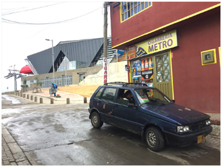
Affiliated with a different route association, a third service operated with eight-seater Nissan Patrols from the 1980s, departing from a designated lot in San Francisco—a neighborhood of informal origins at the base of the hillside that dates to the 1950s, heading toward El Paraíso–the neighborhood where the most distant and final TransMiCable station was under construction. Vehicles departed every five minutes during peak hours and every 10 minutes during off-peak hours (Figure 3). At the route-end checkpoint, a coordinator from the association recorded departure times and logged any unforeseen events, which were reported to route heads responsible for overseeing operations.
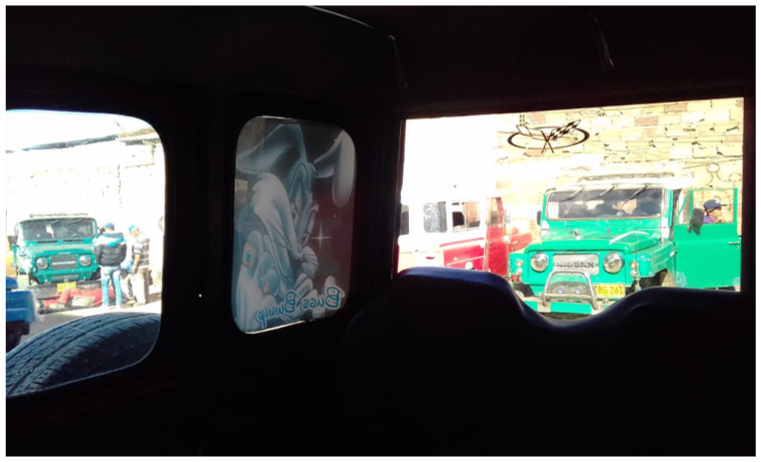
San Francisco – Mirador/Paraíso route terminal.
The remaining seven services followed the fill-and-go model prevalent in other cities in the Global South, where vehicles departed only when full. This practice enabled service providers to manage fluctuating travel demand and make a profit in lower-density areas. However, while such a flexible departure structure lowers operators’ risk, it affects passengers, as wait times can fluctuate from a few minutes to up to an hour depending on the time of day (Cervero and Golub, 2007).
Most routes following the fill-and-go model connect two or three neighborhoods, some of which are at an earlier stage of development, to centers of economic activity within Ciudad Bolívar. For instance, one route connected the commercial main street of El Paraíso with the rural village of Quiba Baja. Another route connected Nutivara—another local commercial hub—with the neighborhoods of Santa Marta and Canada, both in their early stages of development, characterized by unpaved roads and one-story self-built houses.
Network gaps, topographical challenges, and competitive advantages
Consistent with the large body of research, the informal transportation market serving this part of Ciudad Bolivar fills gaps in the public transit network. Caused by various issues connected to the topographical and physical attributes of Ciudad Bolívar, some of these service gaps are considered temporary, while others are more permanent.
Interviews suggest that some informal transportation services primarily serve areas with low bus frequency and unreliable service. As one community leader noted: The SITP [Integrated Public Transportation System] provides service, but a very, very poor one; the frequency is too low, and sometimes one can wait up to an hour for a bus. People who get up early, at 4:00 or 5:00 a.m., may wait indefinitely. The service for peripheral neighborhoods is bad. There is no permanent service that serves the community.
Also consistent with the literature, most informal transportation services in Ciudad Bolívar fill a temporal gap left by public transit routes that stop operations before midnight. Others serve areas with no public transit coverage at any time of the day. One community leader explained: Those who depart from El Paraíso are on informal routes with service available in that location sometimes from 10:30, 11:30, and 12:00 p.m. … because, at that time of the day, TransMilenio [the city’s BRT] is not open, and there are not any of those bus services [BRT feeders serving Ciudad Bolívar] available. Other informal transportation services serve areas without service at any time of the day, such as the Santa Marta, Naciones Unidas, and Canada neighborhoods.
Beyond the commonly cited spatial and temporal gaps, other gaps emerge as short-term adaptive responses to rapidly changing conditions in the public transit system (Kerzhner, 2022). In addition to deviating from designated routes to avoid peak-hour bottlenecks, a typical short-term adaptation in Ciudad Bolívar involves informal operators responding to calls from cooperative heads or fellow drivers to pick up passengers stranded when public buses break down or are involved in a traffic crash. These disruptions—often attributed to the district’s steep topography and poor road infrastructure—create temporary gaps in the network that informal services quickly fill.
Planners turn some of these intermittent gaps linked to temporal service suspension into permanent gaps, as a community leader noted: The bus route ended at the school over Centenario Road, but because the road was too steep and had many potholes, they [the planning authority] decided to suspend it. Because it [the bus] could suddenly go over the school and run over lots of children, so that is why they removed the route and sent it down the road, to the Arabia [sector]; it was last year that the route was removed.
Many of these gaps are recognized by planners, who are aware of the competitive advantage informal transportation holds over formal buses. A transportation planner noted: Locals have identified things like stops, links in the networks, whereas, because of geographical or temporal gaps, or in terms of route headways, informal transportation can compete. Let’s say that this is why it has an important role.
By looking the other way, planning authorities tacitly acknowledge the relevance of informal transportation in meeting demand left unserved by centrally planned transit systems—a point repeatedly emphasized in the literature (Cervero and Golub, 2007; Kerzhner, 2024; Mittal, 2022). However, despite its importance and well-documented role in filling service gaps, the territorial, political, and institutional dynamics driving the emergence and persistence of informal transportation in urban peripheries remain poorly understood.
Adapting to TransMiCable: Market growth, territorial order, and power dynamics
Contrary to what some reformists may expect, the informal transportation network in Ciudad Bolívar grew—both in the number of routes and in overall coverage—once TransMiCable opened, further intensifying competition among route associations and services. This growth involved both expanding an existing service and introducing two new routes (Figure 4).
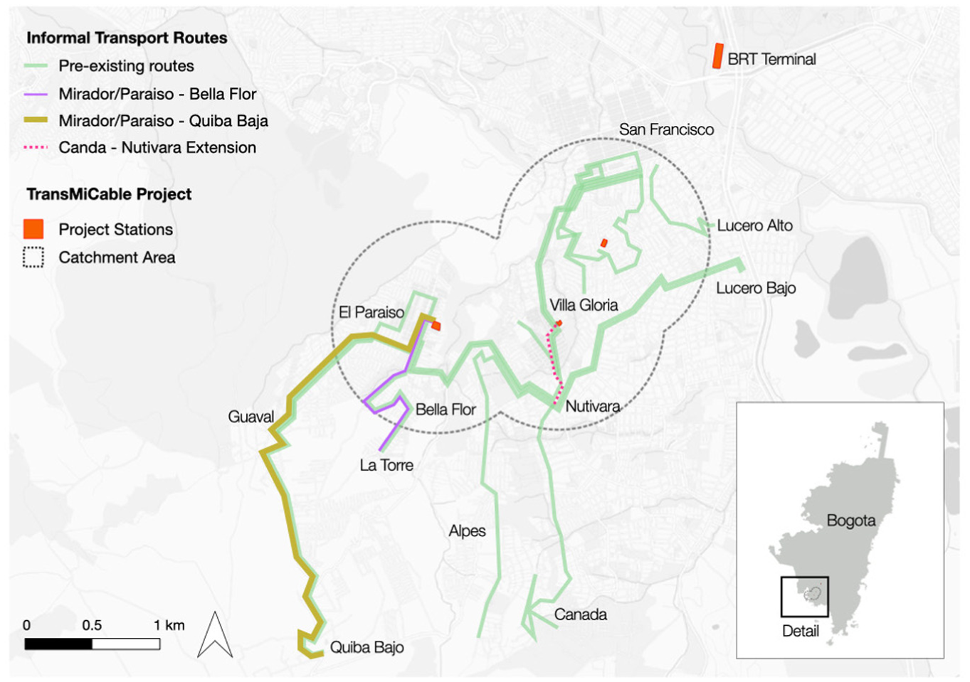
Informal transportation market growth amidst TransMiCable.
Insights from interviews paint, however, a more complex picture of this market growth. Social dynamics, along with other key forces and actors, including land markets, neighborhood organizations, and historical processes of formalizing neighborhoods, help explain how informal transportation adapts to urban change and expands as the urban periphery grows. This perspective is fundamental, as it recognizes the socially and territorially embedded nature of informal transportation and how these are linked to its widely acknowledged role in filling network gaps.
For example, operators of the Canada–Nutivara route provide an on-demand route extension that connects their route-end terminal to a TransMiCable station. One of its drivers explained: “If people ask us, they do not have to walk all the way to the station. We help them get there … We take them to Manitas, and then they take TransMiCable.” Through this adjustment, the route, which had previously served complete trips (from origin to destination), also functions as a feeder service to TransMiCable, organically evolving into an on-demand hybrid direct–feeder route.
The two additional routes that emerged after the opening of TransMiCable share many traits with longer-standing informal services. Both are managed by a new association, Cootransmicable, whose name underscores their role as feeders of the gondola. Using a bricolage of dated sedans and SUVs, these routes nevertheless operate under unusually strict schedules and rules, with vehicles departing every seven minutes, regardless of passenger load, from their terminal located right by the El Mirador–Paraíso station (Figure 5).
Vehicle affiliated with Cootransmicable waiting to depart from El Mirador-Paraíso station.
Market expansion also revealed various social dynamics that led to a new negotiated order. Such negotiations include informal arrangements in which stakeholders delineate which neighborhoods and road segments are served by new versus pre-existing services. The establishment of Cootransmicable involved negotiations with the heads of overlapping routes, resulting in non-competing negotiations that defined corridor segments and stops. As one driver recalled: When they were going to start in December, they came down to talk to us. They told us: “Look, we are going to start this route from that to that part, so we are going to respect your stop … We are going to stop there [pointing to a street near the Paraíso–Mirador station] so that you also respect it.”
Social order is maintained not only through mutual recognition among drivers and cooperative heads but also through strategic relationships with state actors and the power dynamics that also shape the geography of network expansion. One interviewee described how their route association leveraged ties with the local police When I thought about the route from the beginning, I knew it would be based on ten cars … I talked with a policeman friend and told him that we would use only ten cars to work.
Similar patterns have been observed elsewhere—for example, in the growth of the bicycle-taxi sector that now feeds several BRT stations in Bogotá (Heinrichs et al., 2017)—illustrating how informal transportation’s territorial order often depends as much on power dynamics as on agreements among operators.
In addition to relying on local connections, route association heads engage in monetary exchanges with powerful local actors to establish new services. According to neighborhood leaders, local police—motivated by financial incentives—enable market entry and reshape territorial control. As documented elsewhere by Cervero and Golub (2007), these payments serve as a form of site rent, guaranteeing the right to operate in strategic locations. Taken together, these power dynamics shape informal transportation and ultimately influence how these markets evolve.
Network growth, grassroots planning, and peripheral urbanization
Evidence provides further insights into how the expansion of the informal transportation market is intertwined with land development patterns in the urban periphery, while also underscoring how route associations engage in planning practices grounded in local knowledge. Members of the new cooperative, Cootransmicable, recognized urban expansion as a key driver of emerging mobility needs in Ciudad Bolívar’s sprawling periphery. One of the cooperative heads noted that the subdivision of rural land into residential uses beyond El Paraíso would create sustained travel demand necessary for their business to thrive: El Paraíso is the last one [on the edge of the urban footprint]. Still, from here to there, there are rural villages where the population is increasing a lot … each day, those farms are being subdivided to be transformed into neighborhoods.
Their prediction is already evident in the rapid urbanization beyond the Mirador–Paraiso station, documented over four months of fieldwork following the opening of TransMiCable, also captured on satellite imagery. Notably, dozens of land subdivisions for dense, informal housing have emerged toward Quiba Baja—a rural-designated area outside Bogotá’s official urban boundary. Estimates from satellite images indicate that newly urbanized plots have emerged, consuming approximately 60 additional hectares of land between 2017 and 2021, thereby consolidating the urban fringe (Figure 6).
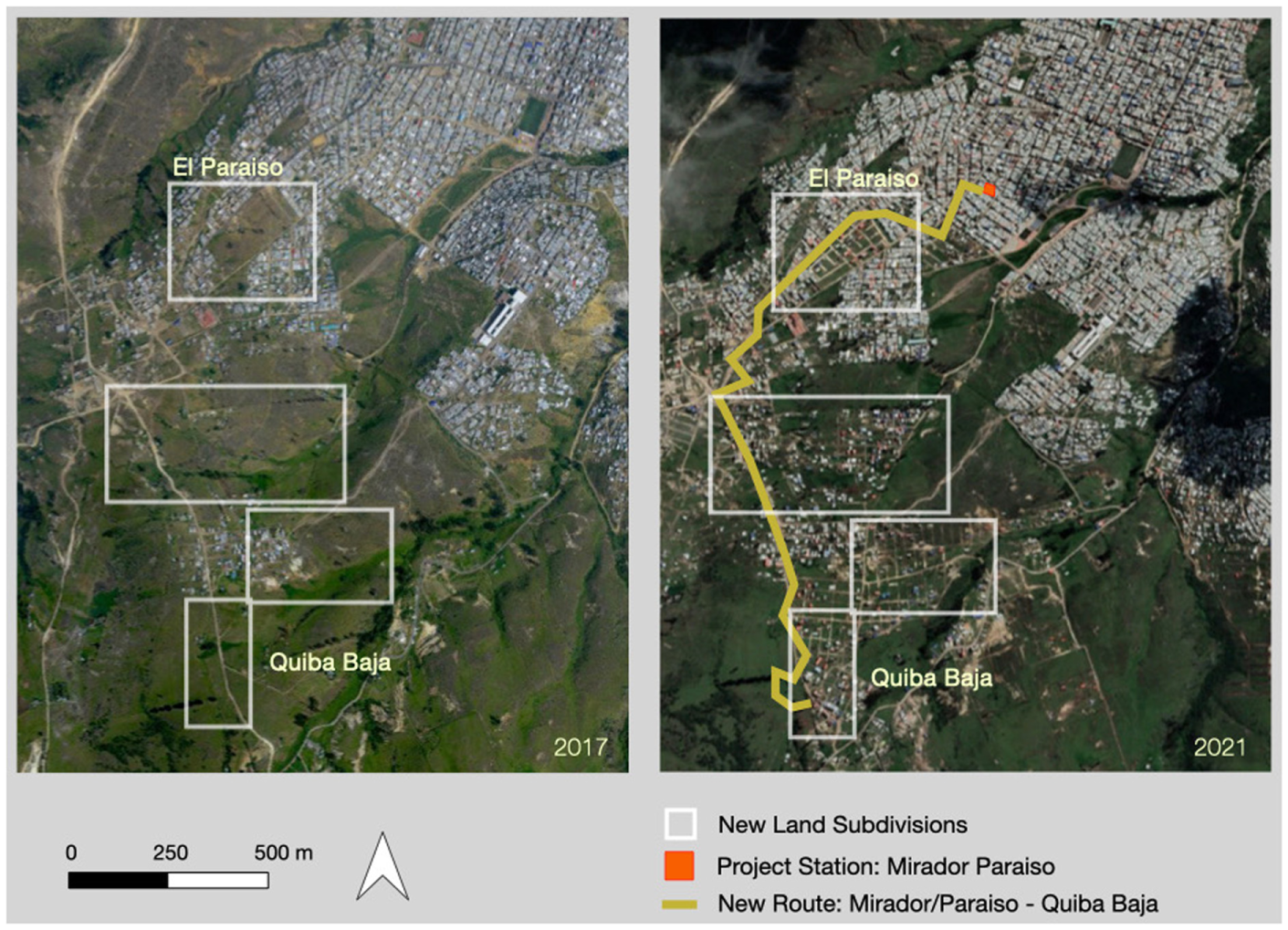
Urbanization in the urban fringe between 2017 and 2021.
Alternative sources of evidence further reveal that land developers in Quiba Baja marketed proximity to TransMiCable and access to informal transportation as part of the bundle of amenities offered by these subdivisions. Brokers advertise parcels on printed flyers and Craigslist-like websites, highlighting connectivity. One ad promised “parcels in the Quiba Baja in Bogotá at only five minutes from the latest station of TransMiCable”—a travel time achievable only via informal transportation routes serving the area.
The combination of local knowledge and strong community ties enabled Cootransmicable members to anticipate and respond effectively to rapidly evolving spatial dynamics and emerging travel demand. These findings demonstrate that informal transportation actors possess invaluable knowledge, serving as de facto planners who devise routes, stops, fares, and other operational features while considering land use and demographic changes (Goldwyn, 2020; Klopp, 2021).
Findings also surfaced how land development patterns and informal transportation services have evolved in tandem over more than seven decades, shaped by neighborhood organizations, residents, and the state. A community leader and former transportation provider described how his neighborhood has consolidated since the 1950s, highlighting the role of informal transportation: When I arrived in the neighborhood, the informal transportation routes began … The first people who came up there were already residents who formed another neighborhood. So, several people at that time said, ``From here up to there, let us put one car, two cars, to work.'' He [referring to one of his neighbors] started with two vehicles working, and then another friend arrived and started working … until the business began to grow.
These connections are most evident in the role informal transportation plays in neighborhood planning and formalization processes—particularly through engagement with state-endorsed Community Action Boards (CABs). Comprised of residents elected through a democratic process, these neighborhood organizations serve as a bridge between the communities they represent and local governments, advocating for essential infrastructure—including water, sanitation, and electricity—as well as land titles, ultimately leading to legal neighborhood recognition (Gilbert and Ward, 1984; Roy, 2005). Interviewees noted that CAB members collaborate with transportation providers during early route planning and lobby decision-makers—including district mayors—for support. One participant, who has offered informal transportation services in the area for more than a decade, explained: These routes emerged because, for example, you [residents] have a need—you see—that the person may need transportation. Then, one gets there and talks to the [Community Action] Board’s president until we agree on the route. A meeting is held with the board leaders, and it is decided that a route will be established, including an inauguration party and everything. So, this type of transportation is created through connections with the board and the community.
In some cases, CABs also support informal transportation associations’ route operations by advocating for road improvements. One driver commented that the route he and his colleagues operate “works thanks to the Community Action Board of the neighborhood.” He added, “They [CAB members] advocated before the local mayoralty, which is now helping us fix the road … The community helps us a lot in that regard. The community has no other transportation alternatives.”
CABs thus act as intermediaries between residents, the state, and informal transportation operators. Their involvement in route planning, advocacy for road infrastructure, and territorial oversight highlights the socially constructed and negotiated nature of informal transportation markets.
Conclusions
This paper capitalizes on the potential disruptive effects of Bogotá’s first aerial cable car line to uncover the socially embedded character that governs informal transportation markets, with a focus on their adaptive response to this infrastructure investment. While informal transportation undeniably fills gaps left by conventional public transit, this study underscores that such gap-filling is embedded within complex social dynamics, shaping how these markets emerge, adapt, and persist in rapidly growing peripheries in the Global South.
Findings reveal that despite the city’s investment in better public transit in Ciudad Bolívar, the informal transportation market continued to grow, surfacing a series of territorial arrangements and power dynamics that govern new and past adaptation responses. New routes now feed TransMiCable, serving newly formed neighborhoods that emerged as part of the peripheral urbanization process, a characteristic feature of cities in the Global South, as Caldeira (2017) contends, but in which the role of informal transportation has been overlooked. Focusing on the socially embedded character of informal transportation was also fundamental in uncovering the historical role of neighborhood-based organizations in early planning stages of informal transportation services, where both groups engage in insurgency planning practices.
Future research should investigate how informal transportation markets adapt to other state-sponsored investments in other urban contexts, ideally documenting changes in market shares and other quantifiable measures. Extending the question addressed in this paper to other contexts is also fundamental to advancing knowledge of the underlying socio-political systems and economic conditions that explain informal transportation resiliency worldwide. Future research could also expand the findings presented here to better understand the potential for integrating informal transportation services with mass transit, as has been repeatedly prescribed in the literature, but rarely seen in practice.
The emergence of new services, their reading of the rapidly growing and informal land subdivision market, and their engagement with local authorities demonstrate the complex political and territorial dynamics that characterize this socially embedded market. One fundamental lesson from this research is that transportation professionals and scholars should not assume that investing in public transit will cause informal transportation to dwindle. State-sponsored transportation plans and policies must account for this reality.
Footnotes
Acknowledgements
Daniel A Rodríguez, Daniel G. Chatman, and Teresa Caldeira from UC Berkeley provided guidance during all stages of this ambitious project. I am grateful for their support and valuable insights. I am incredibly thankful to Patricia Vásquez for helping me navigate Ciudad Bolívar and building trust with community action board leaders. Thanks also to Olga Lucia Sarmiento, Luis Angel Guzman, and Diana Higuera Mendieta from the Universidad de Los Andes for sharing their knowledge and experience in conducting fieldwork in Ciudad Bolívar, and to the three anonymous reviewers for their valuable comments. I am also thankful to all residents, planners, and transportation providers who kindly agreed to participate in this project. Without them, this work would not have been possible.
Funding
The author received no financial support for the research, authorship, and/or publication of this article.
Declaration of conflicting interests
The author declared no potential conflicts of interest with respect to the research, authorship, and/or publication of this article.