
Abstract
There is considerable consensus among scholars of ethnic riots that ethnically mixed areas are more prone to collective violence than segregated ones. The conclusion is based on studies that compare levels of violence between segregated and mixed localities. While this addresses disparities between settlements of dissimilar ethnic composition, variations in the spread of violence across ethnically mixed areas remain a mystery. Seeking to explicate these variations, we propose an approach that examines not only the ethnic composition of a neighbourhood, but also its location in relation to adjoining neighbourhoods of similar or dissimilar ethnic makeup and their shared boundaries. Based on ethnographic fieldwork in Jos, a violence-ridden Nigerian city, we demonstrate that ethnically mixed areas located between segregated ones experience more incidents of violence than mixed neighbourhoods not comparably located. Our findings have both academic and practical implications.
Introduction
Once considered one of Nigeria's most peaceful areas, the city of Jos recently became troubled by ethnic violence of an enormous scale and intensity. Over 1,000 people were killed in a series of ethnoreligious riots that lasted six days in September 2001. After a momentary calm within the city – during which hundreds were massacred in the rural districts of Plateau South – urban violence resumed in November 2008. This time it claimed over 700 lives within two days. 1 Hostilities once again engulfed the city in January 2010, during which at least 200 people were killed within Jos proper and, from March onwards, when more than 400 people were murdered by armed militias in the outlying local government areas (LGAs) of Jos South, Barking Ladi, and Riyom. Overall, more than 5,000 people were killed between 2001 and 2010, distinguishing the Jos riots as some of the most atrocious in Nigeria's modern history. Though contestations over indigene rights and political representation are at the heart of the conflict, violent clashes have been primarily between Christians and Muslims. This is because religious and ethnic identities overlap, albeit not so neatly, and religion offers a wider base for mobilising political support. However, though the literature traditionally portrays perpetrators of violence in Jos as aggregate groups of Christians and Muslims, underneath the cloak of religion are diverse actors that can be further differentiated. On both sides, as subsequent sections will show, the armed mobs that engaged in violence in Jos were assemblages of local criminals, ethnopolitical activists, vigilantes, party loyalists, neighbourhood leaders, retired security officers, residents, and a range of other individuals all driven by diverse interests and motivations. This article's overarching objective is to empirically illustrate how one neighbourhood's demography and location rendered it vulnerable to the cross-neighbourhood activities of these violent hordes.
Plateau South is one of Plateau State's three politically subdivided senatorial zones. The others are Plateau North, where Jos is located, and Plateau Central.
Experts on Jos, like their counterparts in other cities struggling with similar conflagrations, seek to explain the factors shaping the spread and levels of violence (see Krause 2017; Bunte and Vinson 2016; Scacco 2012). Along with population density and poverty, the broader literature highlights ethnic segregation as an important demographic variable in a neighbourhood's susceptibility to violence (see Madueke 2018a). Views are conflicting, however, on how this relationship works (Bhavnani and Choi 2012). One perspective holds that ethnically segregated environments are more prone to violence. According to this view, segregation engenders violence by breeding in-group solidarity and out-group resentment (Boal 1972). Another argument runs in the opposite direction, maintaining that ethnically mixed areas are more prone to violence, and groups should be kept apart in different residential units to avert violent clashes (Kaufmann 1996).
Contrary to the rather determinist stance of these views, both ethnically segregated and mixed neighbourhoods in Jos have had their share of violence. Segregated neighbourhoods such as Angwan Rogo and Angwan Rukuba as well as ethnically diverse areas such as Nasarawa Gwong and Ali Kazaure experienced similarly high levels of violence (see Human Rights Watch 2001, 2009). We propose that in addition to a neighbourhood's ethnic composition, its location in relation to adjoining neighbourhoods of similar or dissimilar ethnic composition accounts for its vulnerability to violence. Specifically, we argue that ethnically mixed neighbourhoods that are sandwiched between rivalling segregated settlements experience more incidents of violence than mixed areas not comparably located. The article will demonstrate that this is because rival armed mobs in the neighbouring segregated areas compete for territorial and political control of the adjoining ethnically mixed settlement usually considered to be a “no man's land” and a prize to be taken by the stronger.
We develop our argument in four steps: First, we discuss relevant perspectives in related literature and then situate our argument. Second, we analyse the historical and contemporary underpinnings of ethnic conflict and violence in Jos and then elucidate our design and methods. Third, we scrutinise the case of Ali Kazaure and how its ethnic composition and location contribute to making it a site of persistent collective violence. Specifically, we show how spatial adjacency and social networks that criss-cross the shared boundaries of Ali Kazaure and the rivalling adjoining neighbourhoods make it easy for external actors to infiltrate the neighbourhood. In doing this, we also show that despite the changing ethnic composition of the neighbourhood, levels of violence remained fairly constant, indicating that ethnic composition alone cannot account for variations. Fourth, we cross-validate our findings in Ali Kazaure by surveying four other ethnically mixed neighbourhoods, two of which are sandwiched between rivalling segregated areas.
Related Literature
Scholars agree that a locality's ethnic composition affects its susceptibility to violence, but they disagree on how the two variables interact. One perspective holds that ethnic segregation promotes violence (Peach 2007); the other maintains that ethnic diversity increases the likelihood of frictions, thereby fostering confrontations (Kaufmann 1996). Empirical evidence is conflicting, supporting one perspective in some instances and disproving the same in other contexts. For example, Bhavnani et al. (2014: 1) found that the increased levels of segregation that followed frequent violent unrests in the 1960s and 1970s in Belfast helped prevent resurgence in subsequent years. In Baghdad, Weidmann and Salehyan (2013) similarly noted that a sharp decline in group violence corresponded to a sharp rise in residential segregation. But evidence from other cases suggests the opposite: Cunningham and Gregory (2014) demonstrate that segregation has contributed to deepening sectarian animosity. They observed that the demarcations in Belfast known as peace lines, constructed to segregate Catholics and Protestants, have accomplished the unintended objective of formalising religio-political differences that feed into a cycle of reproducing spatial and social distance. Rather than entrenching order, such peace lines have served to concretise narratives of inclusion and exclusion that are crucial for the perpetuation of collective violence. Jarman and O'Halloran (2001) also note that such interfaces, while aiming to separate sectarian rivals, have counterproductively increased the incidence of rioting.
While these perspectives offer relevant insights into the factors that make different spatial contexts riot-prone, they do not pay attention to how the location of a neighbourhood in relation to surrounding areas of similar or dissimilar ethnic compositions can shape its vulnerability to violence. Moreover, overlooking the salience of neighbourhood location is partly responsible for the conflicting conclusions in the literature (Madueke 2018b). In Jos, both ethnically segregated and mixed settlements experienced some form of violence as the riots raged. However, incidents of violence significantly declined in segregated neighbourhoods as they became totally homogeneous over time (Krause 2011: 32). This indicates that complete ethnic segregation does curb violence, at least in the short term, if not permanently. One study found groups in the segregated areas of Jos to be more capable of mobilising and defending their neighbourhoods against invasion by external fighters than their counterparts in mixed settlements (Madueke 2018b). This piece of evidence partly accounts for variations in the spread of violence between ethnically mixed and homogeneously segregated settlements as far as Jos is concerned.
Nonetheless, a good part of the puzzle related to ethnic composition and collective violence is still unsolved. There is no adequate explanation for why some mixed neighbourhoods become sites of persistent violence while other equally diverse areas remain relatively peaceful. Experts on Jos have made important contributions towards understanding this enigma. One such effort maps how the city's neighbourhoods transformed from mundane residential areas to spaces of ethnic differentiation and violence. It argues that through exploring two distinct types of socio-spatial settings – ethnic strongholds and frontiers – we can understand the spread and patterns of violence in the city (Madueke 2018b). In her analysis of variations in levels of violence, Krause (2017) found that what distinguished non-violent neighbourhoods from those that experienced violence was the presence of a civilian violence-prevention network. In other words, neighbourhoods that were equally vulnerable but stayed unscathed have civilian networks to thank. Based on a paired comparison of a violent and a non-violent violent neighbourhood, she empirically demonstrated how a joint Christian–Muslim patrol and influential community leaders contributed to making Dadin Kowa an oasis of relative calm even when nearby areas were boiling.
Further, Jos-focused literature emphasises power-sharing and poverty as important explanations for violence and non-violence across the city's neighbourhoods and districts. Comparing Jos and Chikun, Bunte and Vinson (2016) observed how localities with a power-sharing arrangement are less likely to experience ethnic violence; they attribute this to the tone of politicians being more conciliatory and there being more mutual trust among members of the public than in areas without such arrangements. Explaining why poor neighbourhoods of Jos experienced higher levels of violence than the wealthier ones, Scacco (2012) empirically illustrated how poverty increases the likelihood of riot participation. The literature has long identified poverty as one of the structural underpinnings of ethnic violence in Africa (Elbadawi and Sambanis 2000), but explaining the relations at work was always a challenge. Scacco (2012) helped fill this gap by arguing that in circumstances where authorities cannot protect their citizens, poor residents of deprived areas will pick up arms to defend themselves in the face of riots.
Such perspectives advance our understanding of factors affecting the spread and level of violence, but some gaps persist. To start with, while the presence of a civilian violence-prevention network does suggest why some neighbourhoods were violence-free during some riots, an unanswered question is why other neighbourhoods with similar civilian violence-prevention arrangements, though initially non-violent, did experience riots at some point. For example, reports indicate that
in some areas, Christians and Muslims set up joint patrols in a bid to limit the spread of violence, but it became difficult to maintain these once the fighting had escalated. (Human Rights Watch 2001: 9)
Such civilian networks fall within Keegan's (1993) “contingent” factors as opposed to “permanent” operating factors such as physical terrain. Contingent factors are important for determining violence and non-violence circumstantially, but factors such as neighbourhood location and boundaries affect vulnerability to violence in a more permanent sense. We agree with Bunte and Vinson's (2016) argument that power sharing explains variations in the spread of violence at the levels of LGAs and districts. However, there are also variations within LGAs and districts (e.g. across neighbourhoods and even streets) that power sharing at these higher spatial scales cannot account for. We consider poverty, as argued by Scacco (2012), a crucial factor to consider in accounting for riot participation; for our purposes, however, it serves more as a control variable than an explanatory one.
We maintain that variations in the spread of violence across demographically identical neighbourhoods remain a mystery because research has not adequately considered the location of a neighbourhood in relation to adjoining areas. Bridging perspectives in the broader literature on ethnic composition, location, and collective violence, we propose that when considering susceptibility to violence, it is not just the neighbourhood's ethnic composition that matters, but also its location in relation to surrounding neighbourhoods of similar or dissimilar ethnic composition.
We are not the first to consider how locational attributes affect a neighbourhood's propensity for collective violence (for case studies of other cities, see Calame and Charlesworth 2011). Jarman and O'Halloran (2001) observed that in Belfast the “buffer zone” – a type of interface where a mixed settlement falls between two segregated neighbourhoods – is more violence-prone than homogeneous neighbourhoods divided by sharp boundaries. The underlying logic is that the buffer zone is a place of friction, where two opposing communities come into partial contact. This is consistent with findings related to neighbourhood conflicts in New York. Legewie and Schaeffer's (2016) study found that mixed neighbourhoods sandwiched between rivalling segregated neighbourhoods were more disposed to conflict than fully segregated neighbourhoods with clearly defined boundaries. Apart from being sites of contestation over shared resources, such boundary neighbourhoods are contentious because they are spatial contexts where the homogeneous community life that characterises the segregated neighbourhood is threatened (Legewie and Schaeffer 2016). Although the horrendous violence in Jos does not neatly parallel “the Troubles” of Belfast or New York's neighbourhood scuffles, the dynamic that underlies buffer zones and contested boundaries is similar. It explains how the location of neighbourhoods in relation to adjoining settlements can contribute to making them more or less susceptible to violence.
This type of socio-spatial setting is highly vulnerable to violence because ethnopolitical networks from the adjoining segregated areas compete to dominate it. The key objective is to expel rival group members so as to establish territorial and electoral dominance. Using violence to expel residents who are likely to vote for an opponent has been well documented in Kenya (see Kasara 2014). Riots offer a crucial window to displace members of the rival group. Through their connections with co-ethnics in the ethnically mixed areas, ethnopolitical networks from segregated areas may infiltrate or fully invade the mixed areas when violence erupts. Violence perpetrated by ethnopolitical networks, moreover, presents both opportunities and guises, for individuals to commit atrocities based on economic, personal, and other motivations (Kalyvas 2003).
The notion of the frontier sheds light on the socio-spatial setting discussed in this article. Defining the frontier, Kotek noted that, first, it is an area located “on fault-lines between ethnic, religious or ideological wholes” (Kotek 1999: 228). Second, it is characterised by contestations and struggles for political control between rival groups. Third, it symbolises bigger conflicts, being “emblematic of larger disputed areas or zones” (Kotek 1999: 231). To these distinctive features, we add a fourth: at the frontier, the struggle for control is not restricted to residents within the neighbourhood, but also involves actors from adjoining areas. Although Kotek's frontier originally referred to higher spatial levels such as cities and regions, it has gained currency in characterising battleground neighbourhoods or settlements known to experience intense violence in conflict-ridden cities. Boal (2002) used the concept to explain Belfast's contentious geography and the spatial patterns of Catholic–Protestant violence.
As a result of political developments, violence over the years, increased segregation, and the militarisation of the populace, the neighbourhoods of Jos have transformed from mundane residential areas to strategic spaces of ethnic dissention and combat. This transformation has led to the emergence of two types of socio-spatial settings: ethnic strongholds and frontiers. Strongholds are locales of ethnic exclusivity, characterised by ethnic homogeneity and territorial dominance (Madueke 2018b). Frontiers are sites of fierce competition, contestations, and tussles for territorial and political control. The central argument of this article, thus, is that during riots the frontiers of Jos were not only subject to internal wrangling but also experienced more strain as external social networks in the adjoining strongholds exploited their trans-neighbourhood ties to extend the boundaries of their territorial and political control. Before looking at the fine details of this proposition, however, it is important to first map the historical and contemporary underpinnings of ethnic conflict and violence in Jos.
Identity Politics, Ethnic Conflict, and Violence in Jos
Researchers have shed light on the historical and social underpinnings of ethnic competition in Jos by describing the waves of migration from Northern Nigeria (Freund 1981), the establishment of the city in 1915, and the segregationist socio-spatial organisation of residential settlements by the colonial administration (Plotnicov 1971). The inflow of migrants from the south intensified economic competition with earlier migrants from the north, resulting in one of the earliest violent clashes in Jos. Clear connections have been established between these historical antecedents and regional identity politics in postcolonial Nigeria (Logams 1985; Osaghae and Suberu 2005). The Hausa forms the majority group in northern Nigeria and is by far the most politically dominant. At the dawn of independence, the minority ethnic groups in north-central Nigeria, including in Jos, found themselves under the hegemonic clutch of the Hausa (Logams 1985). Struggles by the minorities to break free and assert their political autonomy started during colonial rule and continued after its end. The incompatibility of these interests has translated into local power struggles, which have in recent decades become violent in tone. The violent conflict between the indigenous groups of Jos and the Hausa is part of this and is, in essence, a microcosmic expression of these political struggles (see Best 2007).
The intense competition among ethnic identities is compounded by Nigeria's citizenship crisis and ambiguities surrounding indigeneity. Nigerian authorities distinguish between indigenes and non-indigenes (or settlers) within states and LGAs (Bach 1997). All over Nigeria, the constituent states and LGAs assign certain rights and privileges to persons and groups considered indigenes. The Constitution of Nigeria, however, only vaguely defines the term, leaving it open to subjective interpretations that are often conflicting. While some base indigeneity on autochthony, others see it in terms of long-time residence and aiding an area's development. The indigenous groups of Jos lay their claims to city ownership and consider themselves the only bona fide indigenes because, they argue, the city was built on land inhabited by their ancestors since time immemorial (Ostien 2009). The Hausa proclaim they qualify as indigenes because they have been around for an extensive period and contributed to the growth of the city since its formal establishment a century ago (see Best 2007). What is more, being a Nigerian citizen does not guarantee the privileges that indigene status does, so who qualifies as an indigene has become a pervasive issue and constitutes a prominent underlying causality in ethnic violence in Jos (Madueke 2018a).
Though its history of ethnic riots goes back to the 1930s, deadly violence in the twenty-first century is what earned Jos notoriety. The scale is unprecedented and continues to baffle observers. As Higazi (2007) notes, religion played a prominent role during the recent rounds of riots in Jos and did so in a way distinct from that of earlier clashes across ethnolinguistic or regional boundaries. The first large-scale violence to occur in modern-day Jos was in 2001, following the appointment of a Hausa man as coordinator of a poverty-alleviation programme in the LGA of Jos North. The violence started in a slum southeast of the city centre. Christians and Muslims engaged in open clashes, using sticks, cutlasses, bows and arrows, spears, petrol bombs, and locally made firearms. Within a remarkably short time, similar clashes erupted in different parts of the city, with mobs killing, maiming, and burning. The police were overwhelmed; it took the military to finally quell the violence six days later. Approximately 1,000 people were killed in the pandemonium. Another round of violence almost engulfed the city in May 2002, but calm was restored and the violence did not spread to other parts of the city. It started with skirmishes between Christian and Muslim party loyalists at an electoral registration centre and ended in mobs rampaging around the Angwan Rukuba, Eto Baba, Nasarawa Gwong, and Dogon Dutse areas. In the end, approximately 50 people were killed and up to 100 vehicles burnt (Nyam and Ayuba 2016: 367). Yet, this was minimal compared to what happened in 2001, or what was to come in 2008. That horrendous violence was directly linked to the LGA elections held on 27 November 2008. Once again, armed mobs killed, maimed, and vandalised. After two days of fighting, 700 people were dead and hundreds of buildings and vehicles had been burnt and/or destroyed. Another round of violence occurred in 2010. Unlike the episodes in 2001 and 2008, which were related to (elected or appointed) political positions, this one was sparked by a seemingly trivial event. On 17 January 2010 a Muslim whose home was destroyed in Dutse Uku during the 2008 violence brought labourers in to start renovating the house, which he owned. An altercation then ensued between the labourers, who were Muslim, and the area's Christian residents on their way to church that Sunday morning. As in previous violent episodes, before long the altercation spiralled into mass killings, replicated in neighbourhoods across the city (Madueke 2018a).
At the time of writing, Jos is enjoying what can be described as a semblance of peace. The visible presence of a military taskforce and the reconciliatory efforts of peace-building networks have contributed to creating some stability. While the city has not recorded any incidents of clashes since 2015, it is still reeling from the large-scale violence of the past. A high crime rate, drug abuse, mutual suspicion, and fear pervade the city's divided society. Neighbourhoods are characterised by a strong presence of miscellaneous networks that combine the characteristics of vigilantes, ethnopolitical interest groups, and criminal cartels posturing as vanguards of defence. These emergent assemblages pose a major security challenge even in times of relative stability (Madueke 2018b).
Research Design and Data
This article is based on an in-depth case study of levels and patterns of violence in Ali Kazaure. This ethnically mixed neighbourhood in the city centre of Jos is located between two segregated settlements, the large Muslim area of Angwan Rogo to the north, and the Christian settlement of Apata to the south. Inasmuch as this in-depth study zooms in on one neighbourhood, we pay close attention to Ali Kazaure's adjacent neighbourhoods. In addition, we worked with a selection of four ethnically mixed areas that are demographically, socially, and economically similar, though they differ in terms of location and the ethnic composition of the adjoining settlements. Like Ali Kazaure, two of these neighbourhoods are sandwiched between segregated settlements; the other two, although also ethnically diverse, are not. These secondary cases are examined, though only briefly, in order to achieve the kind of control required to avoid spurious claims and to cross-validate findings.
We started by comparing recurrence and persistence of violence across all the aforementioned ethnically mixed neighbourhoods. We did this by scanning official reports of violence and hospital records to determine which of the neighbourhoods experienced violence and which did not. We did this for each neighbourhood for all three episodes of ethnic riots. To identify and differentiate patterns and levels of violence, we relied on extensive interviews and discussions with riot participants, surviving victims, eyewitnesses, and other residents. Comparing and combining information from the official reports, hospital records, and our interviews, we created three categories for classifying each neighbourhood's distinct experience of violence: major violence, prolonged clashes lasting several hours and involving a large group of people; no violence; and sporadic violence, isolated and often sporadic violent incidents involving much smaller groups and lasting only a short while. Table 1 presents two neighbourhood samples.
Samples of Violence Levels in Two Neighbourhoods
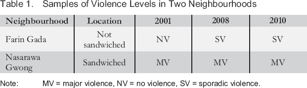
Note: MV = major violence, NV = no violence, SV = sporadic violence.
Table 1 shows how Nasarawa Gwong, an ethnically mixed neighbourhood sandwiched between rivalling segregated settlements, experienced major (persistent) violence in all three episodes of ethnic riots. By contrast, Farin Gada, an ethnically mixed neighbourhood not sandwiched between segregated settlements, experienced no violence in 2001 and only isolated, short-lived incidents of violence in 2008 and 2010. Based on this, we can say Nasarawa Gwong experienced more recurrent and persistent violence because it was violence-ridden in all three episodes of riots; in all three instances, fighting was prolonged and involved a large number of people.
We relied on a variety of data sets from fieldwork conducted in Jos between 2015 and 2017. During this time, besides gathering significant archival materials and official reports of violence, research visits were frequent to Ali Kazaure, its adjoining areas, and several other neighbourhoods. The many interviews and other forms of formal and informal discussions conducted with a diverse group of informants are elaborated later in this section.
We used the ethnic composition of public primary schools as a proxy for the ethnic composition of the neighbourhood in which they are located. We analysed common entrance-examination registers for the graduating classes of 1990, 1995, 2000, 2005, and 2010 as representative samples of the school since these pupils all sit for the common entrance examination, a final written test taken in order to graduate from primary school and gain admission into secondary school. The class register carries the full names of the pupils, year of graduation, and other information. To analyse the data, we scanned the names and categorised them as either “Muslim” or “Christian.” In Jos and across much of Nigeria, an individual's name is usually an indicator of his or her religion. But because this is not always the case, we complemented this method with extensive discussions with school principals and teachers to further ascertain students' group identity and Christian–Muslim proportions.
The choice of public primary schools was informed by two considerations: First, children who attend them come from poor families unable to afford to drive their children to school. These pupils thus reside in the respective neighbourhoods where the schools are located. Private primary schools would not have been an apt data source, because their pupils tend to have parents with cars and can therefore be driven to school elsewhere. Secondary schools, public or private, would also be unsuitable, because their students usually converge from different neighbourhoods. As a second consideration, public primary schools have very comprehensive records that go back decades, whereas most private schools in Jos are recently established.
We also collected hospital records of victims of violence and police reports to determine the spread of violence. Hospital records of violent clashes comprise demographic information such as the name, ethnicity, religion, and address of a victim. They also contain forensic information on the nature and severity of injuries, sites on the body where injury occurred, and any weapon used. For this study, we collected records from four hospitals that received and treated victims of violence within and around the city of Jos from 2001 onwards. Police records specify dates, times, and neighbourhoods or streets where violence occurred; sometimes, numbers of casualties and arrested suspects are also included.
For the purpose of this article, we conducted and analysed 86 interviews concerning the three episodes of violence that occurred in the city between 2001 and 2010: 23 in the ethnically mixed neighbourhood of Ali Kazaure, 19 in the Christian stronghold of Apata, and 24 in the Muslim stronghold of Angwan Rogo. Five interviews were conducted in each of the four other ethnically mixed areas: Nasarawa Gwong, Congo-Russia, Farin Gada, and Mister Ali. Most of the interviews were conducted between 2015 and 2017, but others were conducted between 2010 and 2013. Because of the sensitive nature of the study, interviewees and informants were sampled mainly through snowballing. However, geographical representation, length of residency, and proximity to and knowledge of the issues discussed were important considerations in the sampling process. Because violence forms the core of the study, we were particularly interested in hearing directly from riot participants, victims, and eyewitnesses.
The interviews stemmed from three main discussion prompts: 1) describe how you experienced violence in your neighbourhood, 2) tell us about the main participants in the violence and where they came from, and 3) describe how the violence affected your neighbourhood in terms of social networks (inter-/intra-ethnic relations, neighbourhood associations, etc.). Each of these discussion points was complemented by several follow-up queries that sought to dig deeper than ritualised narratives that may have been rehearsed and told over the years. The duration of the interviews varied, with the longest just under 90 minutes and the shortest only 15 minutes. We employed a thematic system in analysing the data. On the basis of the data and existing literature, we created three coding categories: how violence started (the main instigators and their origin – from within or outside the neighbourhood), patterns of violence (pogroms, clashes, or sporadic isolated incidents), and effects on intergroup and intragroup relations (civic and quotidian networks). After disaggregating the transcribed text into these categories, we ordered the categories into themes before sequencing those themes into a chronological account.
The data sets are not without some biases and limitations. In relation to ethnic composition, it is possible for a group to be overrepresented or underrepresented in a school or a class simply by chance. We believe, however, that these chance possibilities have a way of balancing each other out. There are widespread allegations that the police force favours Christians since it is controlled by the state government. But since we are not interested in adjudging who is the aggressor and who is the victim, but rather being able to corroborate the spread of violence, police bias is of little consequence for the outcome of our study. Ultimately, to circumvent these problems – and recognising the possibility of people's memories being distorted or subjects being deliberately misleading in interviews – we conducted a “ground-truthing” exercise that involved visits to the neighbourhoods and extensive informal discussions with residents.
Ali Kazaure's Location and Cross-Boundary Violence
In this subsection, we empirically demonstrate how Ali Kazaure's location between rivalling segregated settlements made it susceptible to invasion by external armed mobs from the surrounding areas. Following this, we explain why joint patrols aimed at preventing incursion by rivalling rampaging mobs from the two ends of the neighbourhood ultimately proved futile.
During all the major episodes of violence in Jos, residents of Ali Kazaure agreed not to engage in any form of violence and to ensure that potential troublemakers from outside the neighbourhood were prevented from coming in. In all instances, this security arrangement worked up to a point but eventually became overwhelmed by pressure from external armed mobs. When the 2001 riots started, Ali Kazaure's vigilantes mobilised other young residents and kept vigil to ensure no external fighters came in. This arrangement collapsed the next morning when large armed mobs from the adjoining areas mounted pressure and penetrated the two opposite ends of the neighbourhood. Hordes of fighters from the Christian areas of Apata, Chorbe Junction, and Busa Buji had marched into the neighbourhood and staged a front near the Catholic church. 2 Armed mobs from the Muslim areas of Angwan Rogo and Yan Kaji camped on the other side of the neighbourhood around Eid Square. Figure 1 shows movements of fighters into Ali Kazaure. Some months after the incident, a woman described the day's events in an interview with Human Rights Watch:
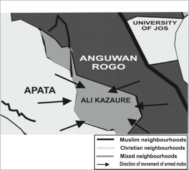
Movements of Armed Mobs into Ali Kazaure
Interview with youth leader, 16 May 2016.
Muslim youths from Angwan Rogo came to Ali Kazaure. They set fire to the Fatima Catholic Cathedral near our house. They had guns and petrol bombs in bottles. Youths from Apata were fighting those from across the street. When the Muslims came with guns, most of them ran away. Some Christians then also got guns and launched a counter-attack. In Ali Kazaure both Christian and Muslim houses were burnt. There was a battleground in the middle. In Apata, most of the houses burnt were Muslim. (Human Rights Watch 2001: 10)
The same pattern of violence was repeated during the 2008 and 2010 riots. In 2010 word about the violence came to Ali Kazaure around 11 a.m. on Sunday, 17 January. Contending armed mobs marched in from the adjoining segregated settlements. Earlier, some prominent individuals had intervened, and residents on both sides had agreed that peace should be maintained at all costs. Vigilantes and other young males that lived in the predominantly Muslim northern part of the neighbourhood were to watch that area to prevent troublemakers from the Muslim neighbourhoods of Angwan Rogo and Yan Kaji from coming in. Their counterparts in the mainly Christian southern half of the neighbourhood were to prevent potential fighters from Apata, Chorbe Junction, and Busa Buji from penetrating. These efforts succeeded at first, but eventually the barricades on both sides of the neighbourhoods collapsed and fighters from the surrounding neighbourhoods invaded. Christians claimed the Muslim residents were the first to let their co-ethnics from surrounding areas in. One vigilante from the Christian side said some of his Muslim neighbours assisted the invading fighters by identifying the homes of Christians for attack. Muslims made similar accusations of Christian residents. One resident of the Muslim side said he saw two Christian residents of the neighbourhood leading fighters from Apata. 3
Interview with former resident of Ali Kazaure, 16 May 2016.
There is no official figure of how many people were killed in Ali Kazaure, but some riot participants and eyewitnesses estimate more than 50 people could have been killed in the two days of fighting in 2008. Though some of these deaths were said to have resulted from arbitrary killings by security forces, discussions indicate most of them were perpetrated by external armed mobs from the adjoining quarters. Apart from these deaths and hundreds of injuries, some 133 buildings were destroyed, making the neighbourhood one of the most physically devastated (Human Rights Watch 2009: 19–20).
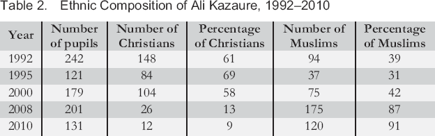
There is no indication that the change in ethnic composition in Ali Kazaure affected levels of violence. As indicated in Table 2, one outcome of the several episodes was an increasing level of ethnic segregation. Between 2001 and 2010, many Christians either fled the neighbourhood or relocated further south, closer to the Christian stronghold of Apata. From a fairly mixed area with a Christian–Muslim percentage ratio of 52 to 48 in 2000, the population had become 91 per cent Muslim by 2010. Despite this huge change in ethnic composition, nothing indicated lessening or heightening ethnic violence. Levels of violence remaining fairly constant despite the change in ethnic composition points to factors beyond ethnic composition.
Ethnic Composition of Ali Kazaure, 1992–2010
Evidence strongly suggests the different incidents of violence in Ali Kazaure were both instigated and sustained by external forces. Although residents of the area also contributed to the violence, it could have been managed and possibly mitigated before it got out of hand if not for the “bad people from these other areas that kept attacking,” according to a resident who was part of the joint patrols in 2001 and 2008. Several other residents also emphasise the role of external armed groups in fuelling violence in the area. 4 Through alliances with co-ethnics in the frontier, politicians and local thugs and gang members from the adjoining segregated settlements found it easy to infiltrate and even invade whenever violence erupted. 5 The boundaries Ali Kazaure shares with adjacent settlements make it easy for external groups to sneak in and out with the tacit support of their co-ethnics within. The next subsection zooms in on these factors.
Interview with residents, 13 March 2017.
Interview with politician, 13 February 2017.
The Quest for Votes and the Struggle for the Soul of Ali Kazaure
Having highlighted the different instances of cross-neighbourhood violence in Ali Kazaure, the next logical step is to explain how the neighbourhood's location between two rivalling segregated communities enhanced it. Specifically, this subsection illustrates how struggles for territorial and political dominance by rivalling ethnopolitical, criminal networks and various other actors rendered the neighbourhood volatile. Based on its demographic and locational attributes, Ali Kazaure is distinguished by the social factors that define Kotek's (1999) frontier. Struggles for political control form part of group dynamics in the neighbourhood. Group relations are beleaguered by the question of who “owns” the settlement. Ethnopolitical and criminal networks are perpetually trying to assert themselves against rival coalitions. Struggles for political and territorial ascendancy manifest in the form of contestations and skirmishes at polling units during elections. The struggle for the ownership and soul of Ali Kazaure is a reflection of a broader conflict at the city level. The predominantly Christian indigenes and the mostly Muslim Hausa are entangled in a longstanding feud over who “owns” the city. This partly explains why the struggle for the control of the area is not restricted to residents within.
To appreciate the struggles in Ali Kazaure, we must first understand how things work in the polling units of Jos. Polling units in segregated areas are usually “owned” and controlled by local politicians through criminals who dictate what happens at these units during elections. Residents are coerced into voting for the criminals' benefactor. In extreme cases, these antisocial elements hijack the ballot box and thumbprint the ballot papers as they wish (see Sadiq and Ibrahim 2015). That is why the voting pattern in the polling units located within the segregated neighbourhoods that border Ali Kazaure is unidirectional, as illustrated in the examples shown in Table 3. Almost 99 per cent of the votes in two polling units in the Muslim settlement of Angwan Rogo go to the All Progressives Congress (APC), a party associated with Muslims in Jos. Similarly, most of the votes in the Christian area of Apata go to the People's Democratic Party (PDP), a political party with strong local Christian backing.
Voting Patterns in Ali Kazaure and Adjoining Neighbourhoods in 2015 General Elections
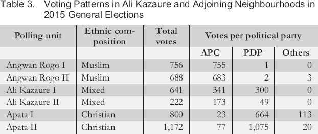
By contrast, as indicated in the rows representing Ali Kazaure, votes are divided in ethnically mixed areas, where local criminals divided along ethnic lines work for different political contestants. In Ali Kazaure, there is a perpetual struggle between opposing criminal networks working for different paymasters for control over what happens at the polling units. Rivalling criminal networks from the adjoining settlements come into the area to support their co-ethnics in the struggle to gain the upper hand. 6 This external intervention makes the settlement more susceptible to contestations than ethnically mixed neighbourhoods that are not located between segregated settlements.
Interview with local politician, 13 May 2016.
Moreover, because of the contiguous boundaries that Ali Kazaure shares with the adjacent segregated settlements, both quotidian and formal social ties criss-cross their shared boundaries. Memberships of social networks including residents' associations and vigilantes are also cross-cutting. Some young men in Ali Kazaure are members of the youth associations and vigilante groups in Apata, while others are members of the youth associations in Yan-Kaji. These cross-neighbourhood memberships form along ethnic lines. Criminal networks exhibit patterns similar to their civic counterparts – for example, “political thugs” from Angwan Rogo and Apata usually collaborate with their co-ethnics within Ali Kazaure to rig elections. 7 Within Jos's ethnically polarised landscape, these networks are known for instigating and perpetrating violence in times of riots. Through their connections with co-ethnics in Ali Kazaure, criminals from the segregated settlements find it easy to infiltrate the area whenever violence breaks out. As noted earlier, riots represent opportunities to expel ethnic rivals and establish absolute territorial control.
Interview with youth leader, 16 May 2016.
Cross-Validating with other Ethnically Mixed Areas
Juxtaposing official reports on incidents of riots, hospital records of victims, and interviews with riot participants, survivors, and eyewitnesses gives us a fair idea of the spread and levels of violence across the neighbourhoods of Jos. Table 4 shows the recurrence and persistence of violence across five ethnically mixed neighbourhoods. The frontier settlement of Ali Kazaure is among the most violent areas of Jos. Along with Congo-Russia and Nasarawa Gwong – ethnically mixed areas that are similarly sandwiched between segregated settlements – Ali Kazaure experienced major violence during all three episodes of ethnic riots.
Recurrence and Persistence of Violence across Ethnically Mixed Neighbourhoods
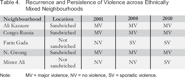
Note: MV = major violence, NV = no violence, SV = sporadic violence.
To further allay possible concerns that these claims were spurious, we cross-checked how dynamics played out in other ethnically mixed settlements. The two goals here were to determine whether ethnically mixed areas that fit the profile of the frontier experienced the same level of violence as Ali Kazaure and, conversely, whether ethnically mixed areas that are not frontiers did not experience similar levels of violence.
The frontier areas of Nasarawa Gwong and Congo-Russia show patterns of violence similar to those experienced in Ali Kazaure. To start with, these neighbourhoods, not unlike Ali Kazaure, experienced major incidents of violence in all three riot episodes. In all of them, Christian and Muslim residents had peace pacts; while these arrangements prevented violence at some initial point, they later collapsed largely due to infiltrations by external groups. Figure 2 shows how fighters marched into Nasarawa Gwong from the surrounding areas. The different elements that combined to make Ali Kazaure vulnerable to violence by rampaging mobs similarly converged to make Nasarawa Gwong and Congo-Russia sites of persistent violent clashes. Local politicians, criminals, religious leaders, association representatives, and ordinary residents formed coalitions along ethnic lines where underneath the shared objective of projecting collective interests, each actor is also driven by personal goals that, although not advertised, are crucial motivating factors for violent action.
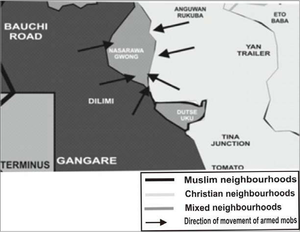
Movements of Armed Mobs into Nasarawa Gwong
The second category of neighbourhoods in the cross-checking process includes mixed neighbourhoods that are not sandwiched between segregated areas. Farin Gada and Mister Ali fall into this group. These areas are either bordered by other mixed settlements or physical (natural or artificial) boundaries in the form of main roads or open spaces. Comparatively, these neighbourhoods experienced far less violence than Ali Kazaure or any of the other frontier areas. Apart from looting and destruction around the market area, Farin Gada experienced only isolated attacks in 2008, which were quickly contained. There was also some low-level violence in 2010, but nothing compared to what happened in the frontier areas. 8 Mister Ali experienced a lot of tension and low-level violence in 2010, but this was as far as the riots affected the area. 9 Neither settlement ridded itself of internal rancour. Many residents wanted to fight, but intergroup dialogues and joint patrols successfully prevented would-be troublemakers from plunging the area into chaos. 10 However, more crucial to explaining the relative calm that reigned in these areas while other parts of the city burned was the absence of external influence, which can be attributed to the location of these areas.
Interviews in Farin Gada, 31 March 2016.
Interview with resident in Mister Ali, 30 March 2016.
Interviews with vigilante in Mister Ali, 30 March 2016.
The struggles in Ali Kazaure are complex and multifaceted, involving different actors from both within and outside the neighbourhood. Local politicians, criminals, religious leaders, representatives of ethnic associations, neighbourhood leaders, and ordinary residents all come together to engage in a battle of wills where ethnic identity remains the most important consideration in building coalitions. The nature and complexity of these alliances echoes Brass's (2004) riot systems and Berenschot's (2011) patronage networks. In situating these civic systems and networks in the frontier settlement of Ali Kazaure, this article showcases how the prevailing atmosphere of ethnic competition in the city is most acutely brought to life in this type of socio-spatial setting.
Conclusion
This article explored the dynamics of ethnic conflict in one of the most violent areas of Jos. In doing so, it demonstrated that besides a given neighbourhood's ethnic composition, its location in relation to adjacent settlements is crucial for understanding why violence occurs more in some areas. The article used the metaphor of the frontier to explain why Ali Kazaure, an ethnically mixed neighbourhood sandwiched between segregated rivalling Christian and Muslim settlements, experienced more recurrent and persistent violence than others. This concluding section reiterates some essential aspects of the argument, highlights their academic and practical relevance, and suggests possible directions for further study.
One of this article's key contributions lies in showing the usefulness of the concept of the frontier in explaining how a particular socio-spatial setting can enhance armed mobs' usage of violence in negotiating coexistence in an ethnically polarised urban setting. The concept has helped us to make sense of how Ali Kazaure's demographic and locational attributes affected civic networks and their repertoire of territorial and political performances in the context of ethnic violence. The second contribution is practical in nature and concerns how authorities ought to respond to conflict and violence in different socio-spatial contexts. On the basis of the findings, it becomes quite clear that certain responses and approaches are more appropriate for particular contexts. On the basis of this understanding, authorities can predict where violence is likely to occur and act proactively.
Another key contribution of the article is its illustration that different socio-spatial contexts – ethnic strongholds and frontiers – differentially affect the production of violence. Neither context, arguably, is less important than the other. Behaviour patterns of groups differ in the two settings, but it is difficult for violence to be instigated – much less sustained – without actors from the two contexts playing complementary roles. In the contested political landscape of Jos, the segregated settlements were conducive to forging ethnic solidarity and marshalling foot soldiers. The ethnic strongholds of Jos proved to be territories where ethnic egotism thrives and both formal and quotidian social networks fuse into fronts for pushing ethnic interests, both politically and violently. Complementarily, the frontier was a setting for whetting rivalry and contestations, and consequently became the battleground.
We also observed that although joint patrols by Christian and Muslim residents in some ethnically mixed parts of Nasarawa Gwong such as Duala and Angwan Keke initially helped keep the peace, these arrangements could not stand the heat when the violence escalated. The sustainability of joint patrols and other ad hoc civilian violence-prevention efforts depends on the intensity of violence, with the success rate diminishing as violence intensifies. However, it is logical that size also makes a difference. The larger a group, the more capacity it has to invade or to prevent invasion. For example, a joint patrol in a small ethnically mixed neighbourhood can hardly withstand a large army of irate youth from much larger segregated neighbourhoods bent on invading the area. However, a populous ethnically mixed area can mobilise a patrol formidable enough to keep smaller armed groups at bay.
This article is an initial step in exploring how the ethnic composition of a neighbourhood, combined with its location in relation to adjoining areas of similar or dissimilar ethnic composition, affects its vulnerability to violence. We used the metaphor of the frontier to explain why ethnically mixed areas sandwiched between rivalling segregated areas experience more recurrent and persistent violence. To better understand riots at the frontier, we also need to examine the micro-level mechanics of violent networks. This would require looking at trans-neighbourhood social networks, their spatial patterns, and the corresponding implications for the mobility of armed networks within and across neighbourhoods during riots. Another direction for further enquiry is to see if there are not-so-obvious variations in the manifestation of the frontier. Such an effort could help produce a typology of frontiers. That, in turn, would open into a nuanced understanding of the dynamics of ethnic violence – specifically, how demography and geography influence group behavioural patterns and shape the production of violence.