
Abstract
Recent estimates suggest that more than 40 million people worldwide are in situations of modern slavery and other forms of labor exploitation. UN Sustainable Development Goal 8.7 addresses this problem and urges stakeholders to take effective measures to end all forms of labor exploitation by 2030. Labor exploitation is often a direct consequence of forced migration, and humanitarian operations have a key role to play in tackling this issue worldwide. Academic research can facilitate this by providing the necessary decision‐making tools to support antislavery practitioners in humanitarian organizations and governments. For effective resource allocation, these practitioners need tools to help them systematically identify and assess the risks of labor exploitation in an area. In this study, we develop a multi‐method approach that combines various data sources to capture the issue's complex and multidimensional nature. Through satellite remote sensing, we first identify 50 informal settlements hosting migrant workers in the strawberry production area of Southern Greece. We then apply a multi‐criteria decision analysis (MCDA) method to a subset of six informal settlements in order to evaluate their labor exploitation risks based on eight criteria. In addition to being practically implemented by a humanitarian organization and a government agency in Greece, our study advances research on humanitarian operations and labor exploitation by elucidating how a multi‐method approach can be used for data‐driven prioritization of interventions against labor exploitation. Our approach offers opportunities for other applications in the field of humanitarian operations.
Keywords
Introduction
The agricultural sector is considered high risk for various forms of labor exploitation, including modern slavery. According to the International Labor Organization (ILO) ILO and Walk Free Foundation (2017), approximately two million people work under the worst forms of exploitation in agriculture‐related activities globally. The use of seasonal workers, the relatively low level of skills required, a strong reliance on outsourcing and agent‐based recruitment of workers increase the likelihood of labor exploitation. Forced migration caused by crises around the world exacerbates this phenomenon. Refugees and migrants often live in illegality and experience serious financial distress, which puts them at high risk of becoming victims of labor exploitation (Cantini and Zavialov 2018, Gold et al. 2015). Governments and humanitarian organizations are key stakeholders in the fight against labor exploitation. Governments are responsible for ensuring equal treatment for migrant and national workers on their territory, and to protect migrants from being employed under substandard working conditions (ILO 2009). Humanitarian organizations such as the United Nations High Commissioner for Refugees (UNHCR), the International Rescue Committee (IRC), or the Danish Refugee Council (DRC) aim to assist and protect the rights of refugees and migrants worldwide. These organizations have a deep knowledge of migration flows across countries, and therefore play a key role in identifying and preventing labor exploitation (UNHCR 2020a).
Fighting labor exploitation in the agricultural sector requires time‐intensive fieldwork, as it involves visiting farms and informal worker settlements. Unfortunately, governments and humanitarian organizations often lack resources to conduct this fieldwork. They need robust tools to help them allocate their limited resources and focus their efforts efficiently on the most severe cases of labor exploitation. In this study, we describe our development of a decision‐making tool that can help the optimal allocation of scarce resources, a typical objective of operations management (Van Wassenhove 2019). We develop a multi‐method approach combining satellite‐based remote sensing technologies for identifying informal migrant worker settlements, ground truthing 1 inspections, and a Multi‐Criteria Decision Analysis (MCDA) model to help governments and humanitarian organizations to assess labor exploitation risks in different settlements and to prioritize their interventions. Multi‐method approaches are particularly useful for studying complex operations problems linked to social responsibility and sustainability that involve multiple stakeholders with sometimes conflicting goals (Besiou and Van Wassenhove 2015, Urrea et al. 2019). Using remote sensing for real‐time data collection allows us to overcome one of the major challenges of research in humanitarian operations, namely the difficulty of accessing data (Kunz et al. 2017, Starr and Van Wassenhove 2014). Our approach also responds to recent calls for the development of MCDA applications that combine different disciplines, use real data, and can be easily applied by practitioners in governments and humanitarian organizations (Besiou et al. 2018, Gutjahr and Nolz 2016).
Our proposed multi‐method approach helps to address the problem of the “unknown unknowns” (Matos et al. 2020 p. 1759) in global supply chain management. It adds to emerging debates on screening methodologies for identifying hidden vulnerabilities in supply chains (e.g., Demirel et al. 2019). Remote sensing technologies allow the screening of remote areas that are difficult to access and so prone to sustainability risks. Our approach responds to calls that operations management research must boldly expand its scope toward developing practical decision tools for grasping and responding to sustainability and human rights violations (Van Wassenhove 2019).
Related Literature
In this section, we discuss the current state of research on labor exploitation and its relation to humanitarian operations. We then present existing applications of our research methods (satellite remote sensing and MCDA) to humanitarian operations.
Labor Exploitation and Humanitarian Operations
Due to its multifaceted nature, labor exploitation has received considerable attention from a wide range of disciplines, including supply chain management (e.g., Cousins et al. 2020, Jacobs and Singhal 2017), political science (e.g., Landman and Silverman 2019), and more recently, earth sciences (e.g., Boyd et al. 2018, Jackson et al. 2020). Despite its increasing relevance, labor exploitation has not often been studied within the context of humanitarian operations. An increasing number of global crises have generated unprecedented levels of migration; it is estimated that currently over 79 million people have been forcibly displaced in the world (UNHCR 2019). These migrants often face extremely dangerous conditions on their journey (Prasad et al. 2020), and easily become victims of labor exploitation (Cantini and Zavialov 2018). International conventions require governments to fight the exploitation of migrants, and to ensure that migrant workers are not treated as lower class workers (ILO 2009).
Most European countries were overwhelmed by the flow of refugees crossing their borders during the 2015–2019 migrant crisis and were not able to ensure appropriate protection for them. Even larger migration flows could occur in future (Van Wassenhove 2019). Many transit and destination countries do not have enough resources to enforce the protection of migrant workers and refugees on their territory, and migrants who are desperately searching for work will continue to fall prey to employers and criminal organizations that exploit them as cheap labor, sometimes being trafficked or even enslaved (Paradiso 2017). This situation is a major humanitarian crisis, and the increasing occurrence of complex disasters around the globe will only reinforce this phenomenon (Starr and Van Wassenhove 2014). Unfortunately, governments alone will not be able to guarantee protection to refugees and migrant workers in future due to growing needs and shrinking resources. Humanitarian organizations such as the UNHCR recognized the fight against the exploitation of migrant workers as a priority and joined government efforts to eradicate it (UNHCR 2017). Non‐governmental organizations (NGOs) engaged in refugee assistance, such as the International Rescue Committee (IRC) or the Danish Refugee Council (DRC), have also joined the fight to protect migrants from exploitation (DRC 2020, IRC 2018). Many local NGOs, such as Generation 2.0 for Rights, Equality and Diversity (G2RED) in Greece, also work with governments to fight labor exploitation, for example, by visiting migrant workers and assessing their living and working conditions. 2 Nevertheless, large numbers of undocumented migrants moving across borders in recent years have strained these organizations’ limited resources (Besiou and Van Wassenhove 2020).
In sum, labor exploitation of migrant workers has evolved from a migration problem to a humanitarian crisis unfolding in many countries, and only coordinated efforts and efficient use of resources will enable this problem to be addressed in an effective manner. Several authors researching humanitarian operations have focused on refugees and how to respond better to their needs. Seifert et al. (2018) provided a detailed analysis of these studies. More recently, Kosti et al. (2020) analyzed how humanitarian organizations and governments can collaborate to improve outcomes for refugees, while ensuring that local communities are not negatively impacted by the presence of migrants. Prasad et al. (2020) developed a framework of migration flows using concepts from supply chain management. However, to the best of our knowledge, no work in operations management has yet studied how humanitarian organizations can better support the fight against labor exploitation of refugees and migrant workers.
Empirical research on labor exploitation (outside of humanitarian operations management) is largely dominated by qualitative analyses using a wide range of data, including organizations’ responses to modern slavery legislation (e.g., Benstead et al. 2018), survivor narratives (e.g., Murphy 2014), and interviews with company executives (e.g., Crane et al. 2019). The hidden nature of the phenomenon (Konrad et al. 2017), the absence of targeted datasets (Weitzer 2015), and the difficulty of gaining access to primary data sources (Chesney et al. 2019) prevent researchers from conducting quantitative empirical studies. Although sparse, quantitative research on labor exploitation tends to focus on a country‐level estimation of forced labor victims (Global Slavery Index (GSI) 2018), or macro‐level factors causing the prevalence of forced labor and slavery in broader terms (Landman and Silverman 2019). While these studies offer important insights into the vulnerability factors that lead to labor exploitation, they do not provide decision support tools that humanitarian organizations and governments can use to fight this phenomenon on the ground (Konrad et al. 2017).
Satellite Data and Humanitarian Operations
In this study, we use satellite remote sensing techniques for locating informal worker settlements. These techniques have been widely used in various disciplines, ranging from natural hazards (e.g., Kougkoulos et al. 2018, Sokat et al. 2018) to crop science (e.g., Daughtry et al. 2005), and urban planning (e.g., Pham et al. 2011), among others.
Satellite technologies have also been used for various applications in the humanitarian sector, such as remote sensing (i.e., imagery and mapping), telecommunication, GPS positioning, vehicle tracking, or predicting extreme weather events (Delmonteil and Rancourt 2017, Starr and Van Wassenhove 2014). In this review, we focus on remote sensing, the technology we use in our study. Remote sensing applications have been used to assess damage after disasters (e.g., Butenuth et al. 2011, Holguín‐Veras et al. 2012), to guide real‐time disaster response operations (Nagendra et al. 2020), to estimate the size of displaced populations (Bjorgo 2000, Lang et al. 2019) or to identify flows of displaced people (Füreder et al. 2015). Although numerous uses of remote sensing in humanitarian operations have been discussed in the literature, there are only a few reports of such applications being used by humanitarian organizations.
Remote sensing data have several benefits for humanitarian operations. They are particularly useful for assisting “voiceless” victims, that is, people who cannot communicate with governments and humanitarian organizations due to the absence of safe communication channels (Nagendra et al. 2020). This is quite common for undocumented migrants in situations of labor exploitation, who do not contact government officials because of fears of deportation. Remote sensing can also save critical resources, because humanitarian organizations can use up‐to‐date data to verify information about the presence of displaced persons (Füreder et al. 2015), even when safety and logistical issues limit access to the field (Lang et al. 2019). Today's computing powers, image‐processing algorithms (e.g., object‐based image analysis), and machine learning techniques allow the automated analysis of remote sensing data, which further increases the efficiency of this technique (Lang et al. 2019), especially when combined with other data sources collected on the ground (Nagendra et al. 2020).
Multi‐Criteria Decision Analysis and Humanitarian Operations
Our study aims to shift the focus of labor exploitation research from the macro level (i.e., country‐level data, factors of vulnerability leading to exploitation, etc.) to an operational, ground‐based evaluation of the risk of labor exploitation, using an operations research methodology. Operations research approaches have been increasingly used in the last decade to tackle various problems in humanitarian operations (e.g., Altay and Green 2006, Altay and Pal 2014, Besiou et al. 2014, 2018, Salmerón and Apte 2010).
As a subfield of operations research, MCDA 3 has been recognized as an important method in decision‐making for formalizing and addressing the problem of competing decision objectives (Roy 1996, 2005). Thanks to its capacity to deal with imperfect qualitative and quantitative information (Chan et al. 2016), MCDA has been frequently used in humanitarian operations applications such as last‐mile transportation, distribution of emergency supplies, and selection of emergency storage facilities (e.g., Ferrer et al. 2018, Jahre et al. 2016, Ye et al. 2020). In their introduction to a special issue on operations research in humanitarian operations, Besiou et al. (2018) called for the increased use of MCDA methods because they enable the assessment of multiple conflicting objectives, a characteristic of humanitarian operations. Gutjahr and Nolz (2016) conducted a review of papers using MCDA for humanitarian operations applications, and while they reported the increasing use of this method, they found that a “majority of the reported methodological approaches still lack concrete application in real‐world contexts” (Gutjahr and Nolz 2016, p. 364). To address this limitation, they recommended that researchers increase their use of real data and appropriate visual user interfaces to create decision support tools for practitioners. Furthermore, they suggested the integration of GIS data collected through satellite remote sensing as one example of such data. More recently, Ye et al. (2020) have reiterated the importance of using real data for developing MCDA methods that are applicable to the practical needs of humanitarian organizations.
Despite these calls, MCDA has never been used, to our knowledge, in the context of labor exploitation interventions. One of the main strengths of MCDA is that it allows researchers to combine information from different data sources, such as remote sensing, ground truthing observations, and questionnaires (see, e.g., Doumpos et al. 2019, Malczewski and Rinner 2015), which are imperative for higher research quality in humanitarian operations (Kovács and Moshtari 2019).
Contribution
Our study contributes to the knowledge base in the fields of humanitarian operations and labor exploitation in three ways. First, we advance the humanitarian operations literature by conducting one of the first empirical studies on labor exploitation affecting migrant workers, a critical area for humanitarian organizations. Our findings reveal that the risk of labor exploitation varies substantially between informal migrant settlements. Based on insights from the academic and gray literature, we develop a set of criteria measuring the risk of labor exploitation in a settlement and validate these criteria with a government agency and an NGO involved in fighting labor exploitation. Our work therefore provides fresh insights into ways to assess labor exploitation risks and prioritize the use of limited resources in humanitarian operations.
Second, this study's key novelty lies in combining different methods and data sources that have not previously been used together in the context of labor exploitation. This removes the barriers usually encountered in empirical research on labor exploitation, such as resource limitations and lack of access to high‐quality data (Weitzer 2015). We demonstrate how remote sensing data enable the identification and location of informal settlements of workers in potential situations of labor exploitation over a large geographic area (140 km2). Identifying these settlements from the ground would require driving around the entire study area in search of possible settlements, which would be costly and ineffective, since many settlements are not visible from the road. Our monitoring process makes use of frequently updated imagery data to identify new settlements built each season. By decoupling different steps of the process (identification, ground truthing, assessment, and intervention), our approach enables a more cost‐effective use of human resources because stakeholders fighting labor exploitation can assign staff with different skills to conduct each step. To date, a team of field investigators has been sent to randomly identified settlements to assess the living conditions and plan an intervention based on their observations, without knowing the needs of other settlements. This ran the risk of exhausting funds before the most critical instances of labor exploitation could be addressed. While some researchers have proposed using remote sensing techniques for locating temporary settlements of forcibly displaced population within an area (Bjorgo 2000, Lang et al. 2019), to the best of our knowledge, no prior study has yet combined satellite data with an MCDA method in the humanitarian context.
Third, our research contributes to practice by developing a decision support system to help governments and humanitarian organizations identify cases of labor exploitation and prioritize their interventions. It provides an easy to administer and publicly available approach that offers a platform for much‐needed information sharing among stakeholders fighting labor exploitation, fostering coordination across organizations (Altay and Pal 2014, Van Wassenhove 2006), for example, to avoid having multiple organizations visiting the same settlement. Our application of an MCDA is one of the few in the field of humanitarian operations to combine a new method with real data (Gutjahr and Nolz 2016), which enhances its suitability for responding to the practical needs of humanitarian organizations. We developed our approach in close partnership with a government agency and an NGO, which both offered valuable insights and validated our choices at several stages. As a proof of its applicability, our approach is already used by these stakeholders (see Appendices S1, S2, S3). Collectively, this research contributes to the UN Sustainable Development Goal 8.7 (UNSDG 8.7), which aims to eradicate forced labor, modern slavery, and human trafficking.
Background and Rationale of The Empirical Case
In order to demonstrate how our proposed multi‐method approach operates in labor exploitation interventions, we focus on the Greek agricultural sector, and more specifically the strawberry production fields around Nea Manolada in the Peloponnese region. The choice of this empirical background was motivated by a 2017 high‐stake ruling by the European Court of Human Rights (ECtHR), which was unprecedented and set a new standard in the history of labor exploitation prevention (Chowdury et al. 2017). Greece is one of the countries that has continued to receive large numbers of refugees and undocumented migrants through the Eastern Mediterranean route since the start of the European migrant crisis (Frontex 2017). Nea Manolada, a small provincial town, has been in the spotlight since May 2013 when three local field guards shot and injured 30 Bangladeshi workers (Gialis and Herod 2014). In March 2017, the ECtHR ruled that the workers in the strawberry fields of Nea Manolada had been subjected to forced labor and that Greece had violated Article 4 of the European Convention by not preventing the labor exploitation of migrant workers (Chowdury et al. 2017). For the first time in history, the ECtHR held a government accountable for failing to prevent labor exploitation. After the 2017 ECtHR ruling, the workers started to receive their wages regularly; however, their working and living conditions did not improve. In July 2018, for example, a fire broke out due to hazardous conditions and burned down an entire worker settlement (Ekathimerini 2018).
As a result of the ECtHR ruling, the Greek government was mandated to ramp‐up its fight against labor exploitation. Investigating instances of labor exploitation requires the identification of informal worker settlements, which are often located in remote places away from existing roads. This necessitates resource‐intensive field investigation work on the ground. Given the limited resources available, the Greek National Rapporteur on Trafficking in Human Beings 4 contacted our research group about the possibility of developing a remote sensing method to help the agency to identify informal settlements and assess their risk of labor exploitation. This initial contact evolved into a close research collaboration, and we met with the Rapporteur and his staff six times during the project to gather feedback and validate our assumptions and results. This collaboration ensured that our proposed approach responded to the specific needs of the government and helped the agency in its fight against labor exploitation (see Appendix S1). Next, we discussed the potential use of our approach with the Directorate of Human Rights from the Council of Europe, which confirmed the applicability of our method in connection with the ECtHR case mentioned above (see Appendix S2). At a later stage in the research process, an NGO involved in fighting labor exploitation in Greece, G2RED, also demonstrated interest in using our approach (see Appendix S3). We met three times with practitioners from this NGO to collect feedback and validate our approach.
Our study focuses on strawberry production, an industry with an elevated risk of labor exploitation, because it is a labor‐intensive crop and its cultivation relies on the availability of cheap labor (Papadopoulos and Fratsea 2017). Such cheap labor often comes from migrant workers, who account for 90% of the agricultural workforce in Greece (Kasimis et al. 2015). Unsurprisingly, the influx of 850,000 migrants in Greece in 2015—an increase of 1600% compared to 2014 (UNHCR 2020b)—resulted in a 14‐fold increase in strawberry production in Nea Manolada over the same period (Hellenic Statistical Authority 2019).
Initial attempts by local NGOs to fight labor exploitation in Nea Manolada included providing legal help and sanitation for migrant workers. For example, G2RED documented the situation month by month with an online blog, 5 focusing on informing Greek citizens and pushing the authorities to take action to improve the workers’ conditions. However, due to the significant increase in arrivals of Bangladeshi workers, who account for 95% of the workforce in Nea Manolada (Papadopoulos and Fratsea 2017), tackling labor exploitation proved to be a difficult task for the government and NGOs. As a result, many migrant workers still live in unhealthy and unsafe conditions in Nea Manolada (see illustrations of living conditions in Appendix S4).
The conversations we held with the Rapporteur at the beginning of the project highlighted the scarcity of resources the government and humanitarian organizations face in response to growing demands, which unavoidably forces them to prioritize their interventions against labor exploitation in the field. There is a clear need for operational decision‐making support so that these organizations can better plan their interventions for improving workers’ living conditions. These interventions include fire safety controls, the provision of sanitary supplies, food, water, and clothing, as well as legal support services and Greek language lessons. Also, timely interventions are becoming increasingly important in Greece; large migrant flows cause congestion in informal settlements, which in turn can lead to significant fire risks.
Our empirical case in Nea Manolada provides two main insights, which we describe in detail in Section 4: (1) a robust estimation method of informal settlement locations in the area, based on the use of remote sensing data; and (2) an MCDA for informal settlement prioritization, providing a complete ranking of a subset of informal settlements, from the highest to the lowest risk of labor exploitation. The results are directly usable by government institutions and humanitarian organizations for optimizing their ground‐based interventions and allocating their limited resources to the settlements with the highest risks of labor exploitation.
Data and Methods
The data collection process took place between April 2018 and November 2019. It incorporated data from satellite imagery, face‐to‐face administered questionnaires, and personal observations. Figure 1 summarizes the five main steps of the multi‐method approach we developed to assess the labor exploitation risks of informal settlements. This process, which can be updated weekly, offers governments and humanitarian organizations a cost‐effective way to constantly monitor the area and identify the creation of new informal settlements.
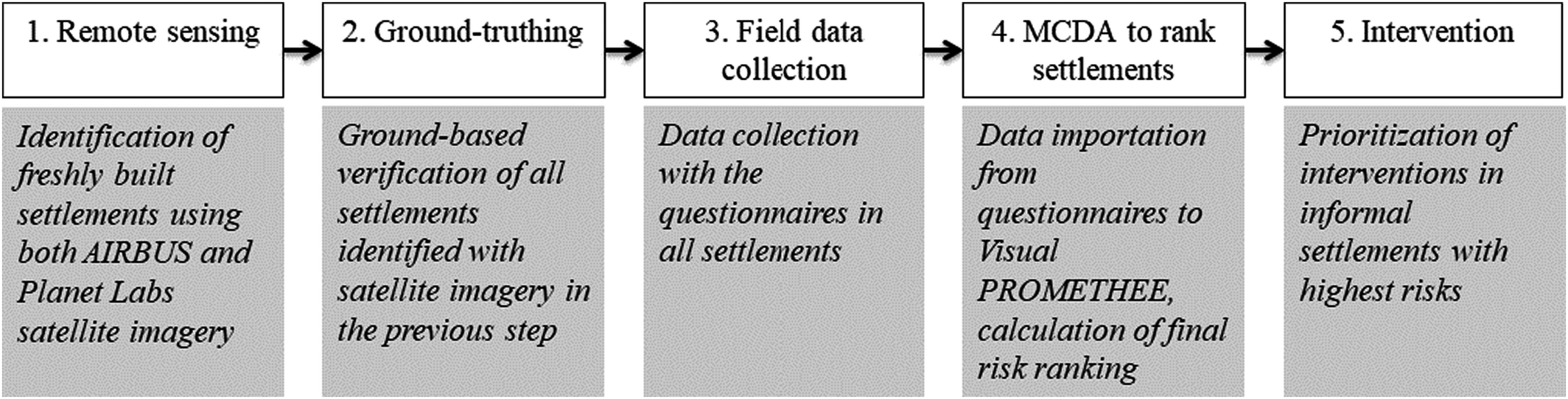
Process Diagram Illustrating The Five Main Steps of Our Multi‐Method Approach
The first step consists of remote sensing the area using Pléiades satellite imagery (AIRBUS 2020) to identify all potential informal settlements that will then be verified on the ground. Once the total number of informal settlements is estimated, we use another source of satellite imagery, PlanetScope (Planet Labs 2020), which has lower spatial resolution (3 m instead of 50 cm) but higher temporal resolution (every week instead of every six months), in order to estimate potential locations for new settlements. Ground truthing in Step 2 aims to verify the existence of the potential locations on the ground. The combination of remote sensing and ground truthing is very cost‐effective, because only suspected locations are investigated, as opposed to covering 100% of the area, which would be nearly impossible. In Step 3, the inspection teams collect data from each settlement using a simple questionnaire to address all criteria for the MCDA (see Table 1). Steps 2 and 3 could be combined, but they require teams with different skillsets, so we present them as separate activities. To test our approach, we performed the ground truthing step on all identified settlements but conducted the field data collection in only six randomly selected settlements (due to time constraints). In Step 4, the collected scores on each criterion for each settlement were inserted in the MCDA software Visual PROMETHEE, producing the full risk ranking of the informal settlements. In this research, we conducted this step with a subset of six settlements, but in actual use the data for all settlements in an area would be inputted. In Step 5, the government and humanitarian organizations intervene in the top‐priority settlements (starting with the riskiest settlement and moving toward the less risky) and allocate resources to the most vulnerable migrant workers to improve their living conditions. Detailed descriptions of the main steps of our approach follow below.
Criteria to Rank Informal Settlements from Highest to Lowest Risk of Labor Exploitation
: (+) the higher the value of the evaluation the higher the risk, (–) the lower the value of the evaluation the higher the risk.
Remote Sensing
There is a plethora of satellite remote sensing data, with some satellites providing free and open source imagery (e.g., Landsat, Sentinel) and others providing only small subsets of imagery commercially (e.g., AIRBUS, NASA). In this study, we use a combination of 50 cm resolution Pléiades imagery (AIRBUS 2020), provided for free on a semiannual basis upon application, and 3 m resolution PlanetScope imagery (Planet Labs 2020), provided for free on a weekly basis following registration.
Informal Settlement Identification using Pléiades Imagery
We used Pléiades imagery for an initial manual object‐based analysis to identify informal settlements in the study area. Two Pléiades scenes were examined (from April and May 2018) covering the entire study area. Since this imagery has a high spatial resolution (up to 50 cm), it is possible to locate the informal settlements and the numbers of housing units. The UN's Glossary of Environment Statistics (United Nations 1997) defines two types of informal settlements: (1) areas where groups of housing units have been constructed on land that the occupants occupy illegally, or to which they have no legal claim; and (2) unplanned settlements and areas where housing does not comply with current planning and building regulations (i.e., unauthorized housing). We use the term informal settlements to refer to collections of illegal housing units and the term housing unit to refer to each single tent or shelter built by the workers themselves. Our first step was to identify the specific patterns in housing units of three known informal settlements (identified by G2RED) located in close proximity to Nea Manolada. These housing units are similar to the polytunnels that cover the strawberry fields, but are smaller in size and follow a random pattern of construction, in contrast to the parallel lines of the strawberry polytunnels, making them distinguishable by satellite.
We then used this satellite imagery to manually investigate the entire strawberry production area (∼ 140 km2) for more informal settlements. While the Pléiades imagery data offer enough resolution to allow such manual identification of settlements, it is a difficult and time‐intensive process. In addition, as the Pléiades imagery data are mostly provided semiannually, unless requested commercially, it is impossible to use them for a continuous monitoring system that is updated on a frequent (weekly) basis to inform the MCDA. For that reason, it is imperative to use data that are updated more frequently to allow for the dynamic monitoring of the area (i.e., to identify potential locations of new settlements).
Informal Settlement Monitoring using PlanetScope Data
In order to monitor informal settlements in the area, we used PlanetScope imagery data, which are updated weekly, but offer a lower spatial resolution—3 m instead of 50 cm for the Pléiades imagery (see Appendix S5 for a visual comparison of these two datasets).
Our goal was to develop an automated method that would provide a dynamic and more robust approximation of informal settlements. As a first step, we collected a total of 32 atmospherically corrected PlanetScope scenes
6
between July 2017 and August 2018 and investigated the new informal settlements that appeared during this period. Next, we calculated the spectral profiles of the pixels in these scenes using the normalized difference vegetation index (NDVI), a common remote sensing algorithm
7
(Costa et al. 2020), in order to distinguish between vegetated and non‐vegetated areas. The NDVI is calculated for each pixel of the satellite image as described in Equation (1), where NIR is the near‐infrared band and R is the red band in each satellite image.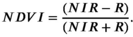
By design, the NDVI varies between −1 and +1, and values that range from 0.3 to 0.8 indicate densely vegetated areas, whereas barren lands and built‐up areas tend to have NDVI values lower than 0.3 (Esau et al. 2016). We examined NDVI spectral profiles of pixels in all eight settlements before and after they were built. All chosen pixels had values greater than 0.3 before the informal settlement existed, and values smaller than 0.3 after each settlement was constructed. The NDVI algorithm therefore provides a robust indication of possible new settlements, significantly limiting the area to be checked manually for new informal settlements. After verifying that the NDVI algorithm is a robust choice for this context, we obtained two extra PlanetScope scenes covering the area (May 2019 and June 2019) in order to update our results (monitor the number of new informal settlements added in the 2019 strawberry harvesting season). Applying our algorithm to these new imagery data proved that our method was successful in identifying the locations of potential new settlements based on the NDVI values. We provide the full list of Pléiades and PlanetScope scenes in Appendix S6.
Location Validation with Ground Truthing
In order to verify that the locations identified in the satellite imagery are actually informal settlements hosting migrant workers, we conducted a ground truthing visit to each location. These visits took place in two rounds, the first in June 2019 and the second in October 2019; the second visit was intended to verify the presence of new settlements found by the monitoring method. During our second visit, we discovered that even though workers tend to leave Nea Manolada at the end of the harvesting season (spring) to work in other agricultural areas, the settlements remain unaltered. This confirms that it is possible to conduct the ground truthing step at any time of the year, even when migrant workers are not living in the settlements.
Field Data Collection
After confirming the presence of informal settlements through ground truthing, we set out to collect data in each settlement to inform the MCDA method (see Section 4.4 for the specific data collected). We conducted this step in June 2019, just after the first ground truthing visit, when between 20 and 40 migrant workers were living in each settlement. These data were collected by two authors (both fluent Greek and English speakers) through face‐to‐face administered questionnaires in each settlement (see questionnaire in Appendix S7). Upon arrival in each settlement, the authors briefly explained the objective of the study, and asked the three most knowledgeable respondents to answer their questions. The authors guaranteed the anonymity of the workers’ responses to ensure they received frank and unbiased answers and to avoid issues with the farmers. While administering the questionnaires, the authors assessed the hygiene and safety conditions of each informal settlement, which enabled data triangulation between the migrant workers’ responses and the researchers’ observations. The authors also assessed one criterion that was not included in the questionnaire—the visibility of the settlement from the nearest road or village (g8).
We conducted this field data collection in six randomly selected informal settlements. Due to time and resource constraints, we had to limit our data collection to these six settlements to demonstrate the applicability of our approach. However, our proposed approach requires analyzing all identified settlements in an area. While this is certainly a time‐consuming exercise, it is important to note that it is only required for the initial assessment of all settlements. After this, our approach only requires field data to be collected in new settlements identified through the remote sensing monitoring (i.e., new settlements built).
Multi‐Criteria Decision Analysis
MCDA methods focus on scoring alternatives based on multiple criteria and incorporating various stakeholder perspectives (e.g., Chan et al. 2016). In practice, MCDA makes it possible to deal with a combination of different decision problems, such as selection, sorting, ranking, and description of alternatives, based on different criteria (Roy 1996, 2005). In the context of labor exploitation interventions, little work has been done to identify appropriate criteria for estimating the risk for workers in situations of labor exploitation. Therefore, before conducting the evaluation of alternatives, we need to describe the problem (description problem) in order to identify the appropriate decision criteria. Due to the lack of existing data, as well as the lack of robust quantification studies in the field of labor exploitation, it is difficult to apply a sorting method (sorting problem) since it is impossible to create classes of risk (i.e., low, medium, high) without objective value thresholds for each criterion. Since the objective of our study is to rank settlements according to their risk of labor exploitation, we opted for a ranking of alternatives (ranking problem) rather than the selection of alternatives (selection problem). This allows us to classify the alternatives (i.e., informal settlements) from highest to lowest risk of labor exploitation, by ascribing to them a numerical value from 1 to n (equal ranks are possible). By doing so, decision‐makers (DMs) from government and humanitarian organizations obtain a final risk ranking of all informal settlements located in their area of interest and are able to allocate their limited resources to the highest risk settlements.
Alternatives and Criteria Definitions
In our MCDA, the model alternatives to be evaluated are the informal settlements, defined as (A1…An). The choice of a coherent set of criteria for evaluation must follow the three rules set by the MCDA description problem (Roy 1996): (1) exhaustiveness (all important criteria are taken into account); (2) non‐redundancy (no double counting of criteria); and (3) consistency (a criterion can only have a positive or negative effect, never have both effects simultaneously). As discussed earlier, no previous study in the literature has defined appropriate criteria for site‐specific assessments in the context of labor exploitation. For this reason, we had to define our own criteria for our MCDA. We first searched the academic and gray literature to identify possible indicators of labor exploitation that could be observed by visiting informal settlements. Then, we shared these indicators with the Office of the National Rapporteur on Trafficking in Human Beings and G2RED to validate our selection. This process resulted in a set of eight criteria (g1…g8) covering various issues, which we describe in Table 1.
The MCDA method we used (PROMETHEE) allows the selection of different preference functions for each criterion, which define how the DM's preference is modeled (Brans and Vincke 1985). We selected the preference functions for each criterion following De Smet (2019), who provides a detailed description about the choices of preference functions in MCDA ranking methods. In particular, we used the Usual preference function for criteria g3, g4, g5, g6, and g8, because it is a good choice for qualitative criteria, including a small number of evaluation levels (like the often‐used 5‐point scale ranging from very poor to very good) (De Smet 2019). This function corresponds to the logic of optimization: the larger the value, the better the alternative. We chose the Linear preference function for the quantitative criteria g1, g2, and g7, which is recommended for such criteria (Brans et al. 1986).
Selection and Basic Operating Elements of MCDA Method and Software
Transparency in the choice of methodology and software is an essential part of an accurate decision‐making process (Wene and Espejo 1999). Due to the plethora of existing MCDA methods and software, new attempts have been made to group multiple methodologies under a single software with more user‐friendly interfaces (e.g., Decerns software by Yatsalo et al. 2016). Nevertheless, not all methods and software are easily accessible and sometimes come at a cost. Wątróbski et al. (2019) underlined that method selection has been an issue in the field of MCDA and therefore created a publicly available selection system. We followed this selection system (see Appendix S8 for details), which showed that the preferred ranking organization method for enrichment evaluation (PROMETHEE—see Brans and Vincke 1985, Brans et al. 1986) is the most suitable method for our work. PROMETHEE is ideal for ranking problems and works with both equal and different weights for each criterion. PROMETHEE has been extensively applied in the literature, apparently due to the variety of user‐friendly software supporting this method, such as PROMCALC (Brans and Mareschal 1994), Decision Lab 2000, Visual PROMETHEE, or D‐SIGHT (Hayez et al. 2012), as well as to its strength in outranking of alternatives (Thies et al. 2019). In this study, we use the Visual PROMETHEE software, which is available for free for academic institutions. Appendix S9 provides more details about the PROMETHEE ranking system we used.
Criteria Weights and Sensitivity Analysis
PROMETHEE allows individual weights to be allocated to different criteria. These weights can be defined based on quantitative (e.g., regression analysis) or qualitative (interviews with stakeholders and DMs) methods (Figueira and Roy 2002). However, the lack of data and the high uncertainty in humanitarian contexts (Kovács and Moshtari 2019) makes it difficult to determine weights based on quantitative methodologies (Stewart 2005). In addition, there is currently insufficient empirical evidence in the literature about the risk factors by which the relative importance of each criterion is determined: extensive fieldwork would be needed to identify the appropriate weights for each criterion. For this reason, we have not assigned different criteria weights in our analysis. Nevertheless, there are numerous mathematical methods that help in the choice of the relative weights to give each criterion according to the preferences of a DM (e.g., Figueira and Roy 2002), and follow‐up work could guide users of our method to determine these weights to reflect the prioritization of one criterion over the other.
In order to confirm the robustness of our approach to possible changes of weights in future, we conducted a sensitivity analysis on the weights as suggested by Brans and De Smet (2016). The method we employed is the random weights preserving a rank order of importance simulation, which was created by Butler et al. (1997). This method is considered ideal for studies like ours, where assessment is conducted by a group rather than an individual DM, and there is no prior knowledge of the relative importance of each criterion (e.g., Dulmin and Mininno 2003, Marinoni 2005). We describe the detailed process and results in Appendix S10.
Intervention
The last step of our approach is intervention by government and humanitarian organizations to fight labor exploitation on the ground. 8 The agency in charge of this step will use the ranking of informal settlements from the MCDA method, allocate its limited resources to the n first settlements in the risk ranking list, and address the issues observed in order to reduce the risk for migrant workers. Such interventions could typically involve providing safe heating and cooking installations, portable showers and toilets, blankets, etc.
Results
The goal of our study was to identify all informal settlements in an area using remote sensing data, confirm their existence through ground truthing, and collect data on the ground to inform the MCDA method, which provides a ranking of settlements from highest to lowest risk of labor exploitation. In Section 5.1 we discuss the remote sensing and ground truthing part of our approach, followed by the MCDA method in Section 5.2.
Remote Sensing for Identification and Monitoring of Informal Settlements
The analysis conducted on the Pléiades satellite imagery (April–May 2018) indicated 52 informal settlements, composed of 2–20 housing units per informal settlement (about 400 housing units in total). The ground truthing we conducted in June 2019 confirmed the presence of all informal settlements identified through satellite observations (except four identified as depots for storing agricultural material). After March 2019, we used PlanetScope data in combination with ground truthing to monitor the evolution of informal settlements in the area during the 2019 harvesting season. Two additional informal settlements were identified from March to June 2019 (and confirmed through a ground truthing visit in October 2019), leading to a final count of 50 confirmed informal settlements. Appendix S11 provides an example of results of the monitoring system for a subset of settlements around Nea Manolada. It is important to note that the figure in this Appendix shows an area of about 4 km2, and manual identification and monitoring of settlements on the ground seems feasible in such a relatively small area. However, the entire strawberry production region we cover in this study represents a total area of 140 km2, which precludes a manual on‐the‐ground search and clearly shows the need for a remote sensing method.
MCDA to Prioritize Locations of Labor Exploitation
From the 50 informal settlements identified by the remote sensing method, we chose a subset of six randomly selected settlements (A1 – A6) to conduct a field data collection and apply our MCDA. Limited time and resources necessitated our focus on only six settlements; however, a government agency or humanitarian organization using our approach would collect these data across all 50 informal settlements. Due to possible safety concerns that migrant workers might face, we do not disclose the locations of the six sites we investigated. Table 2 illustrates the scores from the six settlements on each of the eight criteria, collected through the face‐to‐face administered questionnaires, personal observations, and satellite imagery. The last column shows the output of the PROMETHEE method, the net flow score, which is the basis for the ranking of settlements, with the highest value representing the highest risk.
Risk Assessment Scores of the Six Analyzed Informal Settlements
In settlements A1 and A2, the percentage of workers registered is low, but the percentage of Greek language speakers, the hours of work, and clothing and heating materials provided by the farmers are satisfactory. The hygiene conditions are average while safety measures are poor: gas cylinders are stored in a tent in the sun, stagnant water from ponds increases the presence of mosquitos during the summer months, and there is no running water. The workers have either to use pond water or pay for clean water from the village nearby. A3 seems to be the settlement with the lowest risk: around 60% of workers are registered, and they work nine hours a day on average, which is the lowest of all settlements we analyzed. Nevertheless, while the farmers provide suitable work clothing, they do not offer any material to protect against the cold, and only 10% of workers speak Greek. Settlements A4 and A5 have similar characteristics. Even though the hygiene and safety conditions are average, these sites are hidden and relatively far from any nearby villages. In addition, only 10% of workers speak Greek in A4 and 5% in A5. Only 30% of workers are registered in both sites, and in these settlements they work for more than 11 hours a day. A6 scores poorly on all eight criteria. Only 10% of workers are registered and only 5% speak Greek, which makes it extremely difficult to negotiate salaries and working conditions with employers. Working on average 13 hours per day leads to exhaustion and the extremely poor health and safety conditions severely degrade the human rights of migrant workers in this settlement.
We then input these data into the Visual PROMETHEE software in order to obtain the net flow score of each of the six informal settlements and establish a complete ranking based on their risk of labor exploitation (see Table 2). We observe that labor exploitation risk varies greatly between the six settlements. While A6 has by far the worst conditions for workers, A3 presents the lowest exploitation risk among all six settlements. It is impossible to claim statistical inference based on this limited sample; however, we observe an interesting pattern between these settlements. We find that settlements that are visible from villages and main roads (A1, A2, A3) tend to have better conditions for workers, while isolated settlements (A4, A5, A6) tend to have worse conditions. Examples of the poor hygiene and safety conditions we observed in one of these isolated settlements can be found in Appendix S12. Informal settlements with such poor living conditions are clear indications of labor exploitation, for several reasons. First, it indicates that employers do not provide migrant workers with adequate housing options. Second, during our data collection, we discovered that a considerable proportion of the workers living in these settlements are not legally registered in the country, and as a result they fear complaining about their living and working conditions to local law enforcement. Third, migrant workers often do not speak the local language, which makes it difficult for them to integrate in local communities and easier for employers to exploit them. Finally, there is a hierarchy system among migrant workers, with newcomers usually ending up in settlements with poor living conditions situated in hidden locations far from the villages. Such harmful hierarchy systems are typical in labor exploitation situations (Paradiso 2017).
Our current MCDA model uses equal weights for each criterion, meaning that each of the eight criteria has the same importance in the ranking. To measure the sensitivity of our model to future changes of weights we conducted a sensitivity analysis with 100 iterations using random weights (see Appendix S10). The results confirm that using different weights for each criterion will not change the risk ranking in a substantial way, and the highest risk settlements will remain high risk even if criteria weights change.
Conclusion
The UNSDG 8.7 and international conventions require governments to fight against labor exploitation (ILO 2009), but many transit and destination countries facing massive migration flows do not have enough resources to effectively protect migrant workers and refugees in their territory. Despite an urgent call by practitioners for tools to help them improve the effectiveness of their operations against labor exploitation, this is the first time that such a tool has been developed to address labor exploitation in the terms of UNSDG 8.7. In this study, we apply an MCDA method to rank identified settlements according to their risk of labor exploitation. This demonstrates the suitability of operations research methods for the study of labor exploitation. To demonstrate the applicability of our MCDA model, we randomly selected six informal settlements of migrant workers around the strawberry fields of Nea Manolada (Greece) and compared them using eight criteria to evaluate their labor exploitation risks. Our study also demonstrates that remote sensing techniques can be used to tackle UNSDG 8.7 by offering the capacity to collect useful data remotely and feed it into decision‐making tools such as an MCDA method.
Our study contributes to research on humanitarian operations by conducting one of the first empirical studies on labor exploitation affecting migrant workers and shows how assessing living conditions in informal settlements can reveal instances of labor exploitation. Furthermore, it combines different methods never previously used together in the context of modern slavery. It also contributes to practice by developing specific tools and criteria that governments and humanitarian organizations can use to identify cases of potential labor exploitation. Our approach offers these organizations a cost‐effective way to rank and prioritize their field interventions.
The lack of specific tools to help humanitarian organizations in their interventions against labor exploitation is the starting point and main motivation behind our research. Following an ECtHR decision accusing the Greek government of failing to protect migrant workers in strawberry fields in the area of Nea Manolada, the Greek National Rapporteur on Trafficking of Human Beings contacted us about the possibility of developing such a decision‐making tool. Our research team engaged regularly with the Rapporteur as well as a local NGO to understand their needs and the specific issues related to labor exploitation in Greece. Such frequent interactions (six meetings with the Rapporteur and three meetings with the NGO) enabled us to develop a deep understanding of the context and guided us in developing realistic and relevant solutions to tackle their problems. Our conversations, for example, revealed that the two main challenges in the fight against labor exploitation were lack of available resources and the absence of platforms for systematic prioritization and coordination of interventions among stakeholders. Thanks to our interactions with these practitioners, who validated our decisions at several stages of the process, we were able to develop an approach that addresses these challenges. First, using remote sensing helps government and humanitarian organizations to identify informal settlements from a distance, which frees up resources that would otherwise be allocated for time‐consuming ground‐based search of informal settlements. Second, the MCDA method we propose helps government and humanitarian organizations to collect comparable information in their visits to settlements, and provides much‐needed indications of how interventions should be prioritized. As a result, the government agency and NGOs fighting labor exploitation in Greece adopted and implemented our method—see Online Appendices 1, 2, and 3 as well as point 39 in ECtHR (2020) for more information about the support and use of our approach by these stakeholders. This supports the relevance of our approach to tackling the important labor exploitation problem and demonstrates that we effectively “closed the loop” by going back to practitioners to test and implement the results of our work (Pedraza‐Martinez and Van Wassenhove 2016).
The multi‐method approach we developed in this study has been implemented successfully in the strawberry production area of Nea Manolada. Although we tested it in one setting, our approach can be replicated in other labor‐intensive agricultural activities where cheap labor is abundant. Italian tomato fields (Global Slavery Index (GSI) 2018) or tobacco‐producing regions in Argentina are typical cases where our approach would also work. Depending on the geographical areas studied, the criteria for the MCDA may need to be adapted to local conditions (e.g., the presence of blankets and heating equipment might need to change depending on climatic conditions). Mainly, our approach can be generalized to settings satisfying two conditions. First, informal settlements hosting potentially exploited workers need to have a distinguishable shape that can be identified from a high‐resolution satellite image. Second, the area under investigation needs to be accessible by inspection teams conducting the ground truthing and collecting data from informal settlements.
Our study has a number of limitations, and there is room for improvement to the approach presented in this study. First, due to the lack of previous research and information regarding the relative importance of each criterion of labor exploitation, we assigned equal weights to each criterion to perform our MCDA. However, we expect that once the relative importance of each criterion is known (e.g., after administering questionnaires in all 50 settlements and having collected user experience with the tool), it will be possible to empirically define specific weights for each criterion. Second, we must underline that our MCDA is also subject to a degree of internal uncertainty related to the selection of criteria. Due to the absence of validated indicators of labor exploitation in informal settlements, we relied on the academic and gray literature and insights from our project partners (National Rapporteur on Trafficking of Human Beings and G2RED) to identify the eight criteria used in our MCDA. Future studies could focus on a more detailed analysis and validation of each individual criterion of the MCDA.
Our work opens several avenues for future research, both in the field of humanitarian operations and in supply chain management.
Future studies could extend our approach to different applications in humanitarian operations, for example, to study migration flows, by combining remote sensing with a decision‐making tool such as MCDA for identifying and assessing risks of settlements of forcibly displaced persons in highly fluid conflict situations, like the South Sudan or the Democratic Republic of Congo. Future research can also adapt our approach of combining remote sensing and MCDA to identify other hidden vulnerabilities in supply chains that may cause supply disruption, compromised product quality, or sustainability risks that could potentially damage the reputation of focal companies in sustainability‐aware consumer markets. Similar technological and data‐driven screening approaches may contribute further to detecting and mitigating negative unanticipated outcomes of supply chain designs and strategies. This responds to the motivation of focal supply chain actors to push their visible horizon (Carter et al. 2015) and to increase their supply chain transparency to stakeholders (Sodhi and Tang 2019). Future operations management research can provide quantitative decision‐making tools by using novel sources of data creatively to identify violations of human rights and so contribute to a more sustainable world.
Author contributions
We followed the CRediT (Contributor Roles Taxonomy) author statement to clarify the contribution of each author:
Footnotes
Acknowledgments
This work was funded by an Economic and Social Research Council ‐ Impact Acceleration Account (ESRC ‐ IAA) grant [ES/T501992/1] and EPSRC grant [EP/T001569/1] to the Rights Lab of the University of Nottingham. For future correspondence, please contact Ioannis Kougkoulos (
The term ground truthing is used in geographical information systems (GIS) research to indicate the verification of data on the ground.
We use the term multi‐criteria decision analysis (MCDA) as an umbrella term covering all variants of existing techniques that systematically evaluate different alternatives using multiple criteria, including multi‐criteria analysis and multi‐criteria decision‐making. See Kaim et al. (![]() ) for a detailed categorization of MCDA techniques.
) for a detailed categorization of MCDA techniques.
The agency in charge of fighting human trafficking and labor exploitation of migrant workers in the Hellenic Ministry of Foreign Affairs.
Manolada Watch, see
3 m resolution, 4 bands (RGB, NIR), cloud = 0.
For a description of the NDVI, please see:
Although this process is the formal responsibility of the government, humanitarian organizations such as G2RED often participate in this process as well.
Criteria definitions: g1 Percentage of workers registered; g2 Hours of work per day on average; g3 Suitable work clothing provided by farmers; g4 Hygiene; g5 Safety measures; g6 Measures to tackle cold provided by farmers; g7 Percentage of workers speaking Greek; g8 Informal settlement visible from village and main roads.
PROMETHEE net flow score is the basis for the final risk ranking of the six informal settlements (highest value represents highest risk).