
Abstract
Central Asia's Aral Sea crisis represents a disaster of monumental proportions, a tragedy for both the region's ecology and its human inhabitants. While the human and natural environments had operated in a sustainable co-joined system for millennia, Tsarist Russian expansion into Central Asia, followed by Soviet expansion of both the cotton industry and unsustainable irrigation practices to anchor it spelled doom for the Aral Sea. Today, many of the political and economic stimuli for such misguided practices continue, as do the continued retreat of the Sea and the proliferation of poor human health. The Aral Sea crisis has received ample scholarly attention, though somewhat surprising is a relative dearth of research explicitly investigating the nature, variety, and directionality of nature–society linkages today within the region. The purpose of this paper is to elucidate the contemporary nature–society linkages operating within the Aral Sea region of Central Asia. Historical nexuses will provide necessary background, and the linkages operating currently within the spheres of regional economy, human health, and political considerations will be detailed. Couching the current crisis within the framework of coupled human–environment system contexts reveals a region in which these linkages are largely inextricable. This paper concludes with a call for a reconsideration of the nature-society linkages and a greater emphasis placed on the local region's ecological and social sustainability.
The Aral Sea tragedy provides the most striking example of the interconnections between the health of an ecosystem and that of the economy, community, and people dependent on that ecosystem. (Postel, 2000, p. 943)
Introduction
The Aral Sea, straddling the border separating western Kazakhstan and northwestern Uzbekistan, needs little by way of introduction. Once the world's fourth-largest inland water body, the Aral today is a shriveled, fragmented series of no fewer than six distinct water bodies dotting a desiccated landscape. These remains represent a monumental disaster, the scope and scale of which have few parallels in human history. The largely anthropogenic origin of this disaster has been well chronicled within a broad array of literature (Bissell, 2003; Feshbach & Friendly, 1992; Glantz, 1999; Micklin, 1988; Spoor, 1998). Receiving somewhat less attention has been the important, though admittedly much smaller, influence played by the region's arid clim-atic environment, sparse precipitation, and high summer temperatures (see Micklin, 1988 or Lipovsky, 1995 for such a treatment). The purpose of this paper is to couch the Aral Sea disaster and its contemporary political, economic, and human health manifestations within the multidisciplinary framework of the interrelationship between humans and the natural environment. This analytical framework, referred to here as nature–society linkages, forms an academic pillar within the discipline of geography, as well as political, landscape, and human ecology, sustainability science, and coupled human and natural systems (CHANS). Over the past five decades, this paradigm has evolved from a recognition of the bidirectional relationship between two linked though distinct entities (see e.g. Pattison, 1964), to a treatment of a symbiotic, coupled human-environment system (e.g. Turner et al., 2003). Given the exhaustive examination of the Aral Sea crisis and the ascendancy of the analysis of nature–society relationships, the relative paucity of academic literature explicitly joining these themes is surprising. This paper seeks to fill that scholarly void.
What follows begins with a brief overview of the Aral Sea region, followed by a historical account of this region highlighting the interaction between the regional human populations and the natural physical environment. Contemporary nature–society links, compartmentalized within economic concerns, human health issues, and political considerations, are next discussed, followed by a treatment of linkages operating between these three dimensions. An analysis of the multitude of links will demonstrate the inextricable nature of these connections, and that indeed, what exists here is a tightly co-joined coupled human–environment system. The connections within this system have not been fully appreciated, and today continue to be neglected. This paper will argue that policy prescriptions aimed at improving the overall situation in the Aral Sea region must recognize and consider these interdependencies. Nothing less than the region's environmental and social sustainability is at stake.
The region
The Aral Sea, in reality a landlocked terminal lake with no outflow (Micklin, 1988), is located within the arid environs of Central Asia (Fig. 1). The immediate region anchors an eye-shaped expanse of midlatitude desert (Koppën classification BWk), formed primarily by the Qizl Qum (red sand) and Kara Kum (black sand) deserts. Ringing Central Asia's desert environment are swaths of midlatitude steppe (Koppën's BSk) to the north and east, and subtropical steppe (BSh) to the south and east. Far to the Aral's east and southeast are situated the great orographic masses (Koppën's H) forming the headwaters of Central Asia's major river systems, the Syr Darya and Amu Darya. These rivers together account for the only inflow (surface precipitation and groundwater contributions are minimal) of water to the Aral Sea. The Syr Darya (Jaxartes of antiquity) originates in the Tien Shan mountains of easternmost Kyrgyzstan near the Kyrgyz–Chinese border. Flowing west across Kyrgyzstan, the Naryn and Kara Darya join in Uzbekistan's densely populated Ferghana Valley, forming the main Syr Darya that continues across northernmost Tajikistan reentering Uzbekistan and flowing northwest through Kazakhstan, emptying into the Aral Sea. Referring to the Aral Sea as a single contiguous entity, however, is a misnomer. By the late 1980s, the receding Aral had split into the “Little” Aral to the north and “Big” Aral to the south (see e.g. Micklin, 2006). Today, the Syr Darya empties into the “Little” Aral situated entirely within Kazakhstan's Kyzlorda oblast.
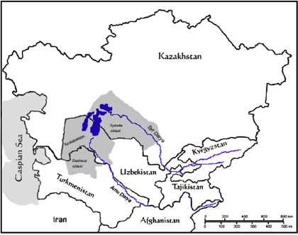
Central Asia and the Aral Sea region.
The Amu Darya (famed Oxus of antiquity) originates in easternmost Afghanistan in the peaks of the Hindu Kush. Flowing generally westward, the great river forms much of the boundary between Afghanistan and Tajikistan, the entire Afghan–Uzbek border, and part of the Turkmenistan–Afghanistan border before turning northwest through eastern Turkmenistan, into the Uzbek autonomous republic of Karakalpakistan, and expiring in the desert near where it once fed the Aral Sea from the south. Worthy of note here is the lengthy Kara Kum canal, a man made irrigation ditch flowing northwest through most of Turkmenistan. This canal was conceived during the early Soviet period as part of a regional irrigation scheme referred to by Grigoryev (1952) as “the Stalin plan for remodeling nature” (p. 170).
Regional analysis of the Aral Sea is fraught with a number of issues. The most natural region would perhaps be the Aral Sea drainage basin, including the Aral itself and the drainage basins of its feeder river systems, the Amu Darya and Syr Darya. Today this natural region is politically fragmented, including portions outside of Central Asia (China, Afghanistan, and Iran) as well as Tajikistan, Kyrgyzstan, Uzbekistan, Turkmenistan, and southern Kazakhstan. The resulting discontinuity between the superimposed political boundaries (human artifacts) and the Aral Sea basin (natural environmental region) forms a fundamental foundation for any analysis of contemporary nature–society links within the region. What remains of the Aral Sea is today shared by Kazakhstan and Uzbekistan. The immediate region, including the deltas of the Syr Darya and Amu Darya, is located within Kazakhstan's Kyzlorda oblast, Turkmenistan's Dashaguz oblast, and the Karakalpakistan autonomous republic within Uzbekistan. These three sub national geographical units, closest to the Aral itself, have suffered the brunt of the ecological and socio-economic consequences of the sea's retreat (Feshbach & Friendly, 1992; Micklin, 2006). As a result, this paper's focus will primarily be on this localized region, the contemporary interactions between its inhabitants and the natural environment surrounding the Aral Sea itself. Some fluidity in regional treatment is necessary, however, particularly in examining historical developments in the wider region of Central Asia, as well as the modern disputes and cooperation between states in the Aral Sea drainage basin.
Early period
Human beings and the Aral Sea region's natural environment have operated in an interrelated system for millennia. The region's physical landscape is singularly marked by its aridity, dominated by two large deserts (the Quizl Qum in Uzbekistan and Kara Kum in Turkmenistan) and vast expanses of arid and semi-arid steppe (throughout much of Kazakhstan). In such an environment, sources of fresh water become of paramount importance to the survival of each of the region's species, including humans. At around 5000 B.C. irrigation within the region began in the northern foothills of the Kopet Dag Mountains in what is today southwestern Turkmenistan (Lewis, 1966). This seminal human adaptation and modification allowed the formation of agricultural production, longer-term human settlements, and ultimately large cities (particularly, in this early period, Urgench and Merv in today's Turkmenistan). Irrigation began to diffuse throughout the region, and by roughly 500 B.C. a spatial dichotomization of the population had appeared. By this time, the Syr Darya River had become a natural boundary between nomadic peoples (Sythians) to the north and sedentary agriculturalists (Sogdians, Bactrians, Khwarazmians) to the south (Lewis, 1966). Nomadic pastoralism within the vast steppe of Central Asia necessitated a cognizance of natural ecosystems and movements in tune with seasonal changes. The formation of sedentary agricultural settlements was preconditioned by the presence of rivers and the development of animal husbandry and irrigation systems. By the fourth century A.D. the area witnessed a decline of irrigation region-wide (Lewis, 1966). This drop off was largely the result of the invasion of the nomadic Huns and concomitant destruction of settlements and irrigation facilities (O'Hara & Hannan, 1999). This first undulating wave of development, ascendancy, and decline in irrigation, lasting over 5000 years, serves as a foreshadowing precursor. Fluctuations in the region's irrigation intensity (though much shorter in amplitude and frequency over time) would continue into the 21st century.
Mongol invasion and aftermath
The second major nomadic invasion of the region, that of the Mongols, began in the early 13th century. In 1219 the Mongols entered what is today Kazakhstan and in two years time had conquered the region and its major cities of Bukhara, Samarkand, Khodjent, Urgench, and Merv (Grousset, 2002). The Mongols recognized that populations, agricultural systems, and entire economic bases owed their existence to a single source of water (typically the Syr Darya, the Amu Darya, or their tributaries). Destruction of a single dam, for instance, resulted in the quick destruction of Merv (O'Hara & Hannan, 1999). In similar fashion, Urgench was flooded by waters of the Amu Darya (Grousset, 2002). The Mongol military success can be attributed to a number of factors (adept command of Genghis Khan, element of speed and surprise, previously unencountered military tactics) though one that must be mentioned was the reliance (and vulnerability) of the sedentary populous on water. This vulnerability was exploited by the Mongols and certainly expedited their conquest of the region.
Human–natural environment linkages beyond military techniques also diffused into Central Asia with the arrival of the Mongols. An appropriate first consideration would be the natural environmental elements that formed the very core of this people's social identity. The Mongols, through endogenously perpetrated legend, believed themselves to be descendant from two steppe fauna species, a wolf and a female deer (Morgan, 1990). These first Mongol inhabitants also brought with them animist tendencies, worshiping the Eternal Blue Sky and the Golden Light of the Sun. Genghis Khan himself sought spiritual guidance atop Mongolia's Burkhan Khuldun (God Mountain) given this locale's proximity to the Great Blue Sky (Weatherford, 2004). Interestingly today, these two environmental elements (the blue sky and the sun and its rays) remain important in the national and political symbology of Kazakhstan, featuring prominently on the state's national flag. Genghis Khan also decreed an end to all hunting during the breeding seasons between March and October, and additionally outlawed unnecessary killing (in an early form of bag limits) beyond what was absolutely needed (Weatherford, 2004). Predating today's hunting regulations and wildlife management programs, this represented an early effort aimed at ensuring the sustainability of wildlife (game) resources.
The Mongols have been referred to as “sons of the grassland” (Smith, 1943, p. 156), and a “spontaneous creation of the soil itself” (Grousset, 2002, p. xi). Lattimore (1938) offers a welcome advance of the deterministic view of the interrelationship between Mongol steppe nomads and the physical environment in which they conquered, lived, and ruled. These nomads lived in balance with the physical environment. In reality, the steppe has a variety of localized, natural conditions. A range of possibilities afforded by ‘nature’ offered the Mongols a range of societal choices with respect to livelihood (Lattimore, 1938). As with all cultures and societies, the natural environment provided constraints (limited possibilities), and the Mongols, like others before and after, adapted. These societal adaptations included domestication of the horse (Smith, 1943), mobile and flexible pastoral nomadism techniques (Fletcher, 1986), and hunting and corralling game on horseback with bow and arrow (Weatherford, 2004). These particular adaptations were also to serve the Mongol invaders well in Central Asia (and elsewhere) in an easy transference to military use.
Russian Tsarist period and colonization
The Russian empire's conquest of and expansion into Central Asia began in the 1730s with the gradual diffusion into Kazakhstan and continued to the 1895 annexation of the Pamir Mountain region of Tajikistan; a 165-year period that brought all of Kazakhstan, Uzbekistan (including the khanates of Khiva and Bukhara), Turkmenistan, and Tajikistan under Russian control, cementing the southernmost boundary of the Russian Empire (Soucek, 2007). In true colonial fashion, Tsarist Russia's vast Central Asian possessions, were viewed as a source of raw materials and potential market for Russian goods. During the latter half of the 19th century, continued expansion of the Russian Empire ever closer to British India made Central Asia the focus of the famed ‘Great Game’ geopolitical struggle between two of the world's colonial powers (see e.g. Hopkirk, 1994).
For the Aral Sea and its regional inhabitants, the Tsarist period was of utmost significance. In 1848, Russian Naval officer Alexey Butakoff led an expedition that conducted the first full navigation and survey of the Aral Sea. The resulting map (now known simply as ‘the Butakoff map’) of great detail and high quality retains its unique scholarly value today. In addition to observations of the Aral itself and the local pastoral inhabitants, Butakoff (1853) also details a number of tiger sightings. The now-extinct Turan (also known as Caspian or Persian) tiger (Panthera tigris virgata) roamed the Caspian region and the riparian habitat along the major rivers of Central Asia, particularly the Syr Darya and Amu Darya (Prynn, 2003). At the time of Butakoff's exploration, these tigers were numerous. Within the next century, the Turan tiger would disappear from the region, due largely to Russian (and later Soviet) active hunting, in addition to increasing human settlement, fragmentation of tiger habitat, and overall decline of the ecological situation throughout the Aral Sea drainage basin (Prynn, 2003).
The Russian Empire's expansion into Central Asia brought with it a decision that would ultimately transform the region's ecosystems and its human economic, social, and political landscapes: the decision to increase the production of cotton within the newly acquired region. By the mid 19th century Russia was dependent upon imports of cotton, largely from the United States (Joffe, 1995). The US Civil War (1861–5) significantly disrupted the American supply of cotton, forcing Tsarist Russia to look elsewhere for this much needed raw material. The Central Asian territories offered great potential in this regard, given the region's long growing season and seemingly ample supply of water from the great Syr Darya and Amu Darya rivers. For successful large-scale cotton harvests, however, the Russians realized the need for a dramatic increase in irrigated acreage and a higher quality grade of cotton (Matley, 1970). In 1870 US cotton (the American Upland variety) was introduced into the region, and irrigated cultivation and production increased dramatically from this time until the Russian revolutions of 1917 (Whitman, 1956). Construction of railroad lines in the 1880s linking Central Asia to Russia expedited cotton exports and brought an influx of Russian agricultural settlers, many of whom quickly seized the most fertile lands (Soucek, 2007). Native populations were also adversely affected by the shift to cotton cultivation, which came at the expense of food crops and fodder for pastoral livestock. As a result, the traditional nomadic existence suffered from the necessity to import food and feed crops, forcing many to settle (Whitman, 1956).
The Russian Empire decision to concentrate cotton production in Central Asia may have initially been considered a success. By the outbreak of the First World War (1914) the region was a major supplier of cotton, allowing Russia to become among the world leaders in cotton production (Whitman, 1956). Even at this early date, however, Russian officials were confronted with a number of difficulties associated with such large-scale irrigation in an arid environment. Not only was such a scheme costly in economic terms, the diversion of river water raised the undergroundwater table, creating water logging and an increased salinization of soils. Swampland increased throughout the region, resulting in widespread malarial outbreaks (Matley, 1970). In the final years of the Russian empire, these societal and environmental costs were overshadowed by war and revolution, though offered warnings ultimately unheeded by the successor Soviet state.
The Soviet period
During the first decade of its existence, the nascent Soviet state's Central Asian populous remained linked to its natural environment as nomadic herders in the steppe regions and sedentary agriculturalists in oases along the Syr Darya and Amu Darya. Tsarist irrigation and cotton production had tailed off in the immediate aftermath of war and revolution. By 1924 boundary delimitation along ethno-linguistic divisions formed the foundation of what, over the next decade, would become the five Soviet Socialist Republics in the region. The Aral Sea and its feeder rivers were firmly situated within the Soviet Union, with only minute portions of the drainage basin extended into Afghanistan and China. The level of the Aral Sea itself was first systematically monitored in 1911, and over the following five decades its level remained fairly stable (Micklin, 2006). During this period the Aral supported a substantial fishing industry, based on the harvest of at least twenty commercially viable fish species (Glantz, 1999). The northern Aral fishing port of Aralsk, Kazakhstan was the scene of a major fish harvest and shipment by rail (14 wagon loads of fish) to ward off famine in Russia. A 1921 letter of request from Lenin to the people of Aralsk features prominently in the town's central square today, as does a mural depicting the event in the town's train station.
In 1929, under Stalin, an effort to collectivize agricultural land, pasture, livestock, and in fact all natural resources, began (Soucek, 2007). This momentous rupture of the human–environment balance had particularly disastrous consequences in Kazakhstan. In protest of confiscation of herds and pasture lands, Kazakh nomads responded by slaughtering livestock. Between 1928 and 1934, livestock losses in the republic amounted to over 70 percent of cattle, nearly 90 percent of sheep, and over 80 percent of horses (Holdsworth, 1952). Resulting retaliatory massacre, widespread famine, and forced out migration saw a precipitous drop of at least 1.2 million in the native Kazakh population (Shayakhmetov, 2007).
The 1930s also bore witness to the disappearance of the Turan tiger from the Aral Sea region and drainage basin. A large influx of non-native human populations into the fertile agricultural oases effectively fragmented the tiger's habitat, dispersing the species and resulting in sharp declines in numbers. Active hunting also decimated specie numbers, as the eventual Soviet ban on tiger hunting in 1947 proved too late to save the now-extinct tiger. The last remaining tigers in the region, populating what was left of the thick reed beds along the Syr Darya, Amu Darya and around Kazakhstan's Lake Balkhash, were killed off during this decade (Prynn, 2003).
Following the Second World War, Soviet planners sought to revitalize the earlier Tsarist era scheme of making Central Asia into a major source of raw cotton. A drive began to dramatically increase cotton cultivation and harvests within this arid region (Holdsworth, 1952). The plan's ultimate success required vast expansion of irrigation infrastructure, as well as sizeable application of fertilizers, herbicides, pesticides, and later defoliants. The expansion and maintenance of the region's cotton monoculture (the crop is referred to locally as ‘white gold’) would, of course, prove disastrous for the region's natural ecosystems and human populations within the following four decades.
The year 1960 represents an important benchmark in the Aral Sea's history. As previously noted, this year marked the end of recent stability in the lake's level. Nearly all accounts of the late-20th century shrinking of the Aral reference its ‘starting’ level in 1960. During the 1950s and 1960s, Soviet plans to expand cotton production in Central Asia required a concomitant increase in irrigation. These planners, in a rudimentary cost-benefit analysis, simply weighed the economic gains of irrigated agriculture against the economic value (presumably the fishing industry) of the Aral Sea. The decline of the Aral was expected and deemed a positive economic outcome (Micklin, 1988).
The Soviet push to increase cotton production continued within the Aral Sea basin from 1960 to the state's collapse just over three decades later. Between 1960 and 1988, area under cotton cultivation rose from 1.9 million hectares to 3.1 million hectares (Pomfret, 2002). Such increases in sown area required more irrigation, more water diverted from the rivers, and ultimately less inflow into the Aral Sea. Irrigation canals were overwhelmingly unlined, resulting in massive seepages into the groundwater, effectively raising groundwater levels and increasing salinization. Also increased was the application of fertilizers, herbicides, pesticides, and defoliants. The resulting cotton harvest results were viewed an economic success by Soviet planners, as the USSR became the world's second-largest cotton exporter by the 1980s (Feshbach & Friendly, 1992). Between 1960 and 1988 Soviet raw cotton production increased from just less than 4.3 million tons to 8.7 million tons (Pomfret, 2002).
This more than doubling of output spelled disaster for the Aral Sea and its region's inhabitants. Between 1960 and 1989, the Aral's area shrank by 41 percent, its volume dropped by 67 percent, and the salinity of its water tripled (Micklin, 2006). The Aral's once-thriving fishing industry was decimated, forcing the closure of processing facilities in Aralsk, Kazakhstan and Moynaq, Uzbekistan. For the region's human populous, bleak employment prospects were compounded by the negative health effects associated with the concentrations of salts and toxic chemicals in the land, water, and food supply. In Karakalpakistan, infant mortality rates were double the USSR average, and even higher within Turkmenistan's Dashaguz oblast (Feshbach & Friendly, 1992).
Independence
With the dissolution of the USSR, the socioeconomic and ecological crisis in the Aral Sea region became inherited by the newly independent states of Central Asia. During the first decades of independence, ecological concerns in the region took a back seat to market-oriented economic restructuring, economic development, and the building and maintenance of political state identity. What remained of the Aral Sea itself was situated in the borderlands between Kazakhstan and Uzbekistan. The drainage basins of the Syr Darya and Amu Darya rivers were additionally shared by Kyrgyzstan, Tajikistan, and Turkmenistan. With water diversion plans and cotton quotas no longer emanating from Moscow, each new state was free to use riparian resources within its own borders as it saw fit. Disputes and conflicting interests could no longer be mediated by Moscow and now fell into the realm of foreign policy and international relations between independ-ent states. Competing interests would therefore translate into potential conflict between upstream states (Kyrgy-zstan and Tajikistan) desirous of tapping hydroelectric energy, and downstream states (Kazakhstan, Uzbekistan, Turkmenistan) reliant upon irrigation.
Realizing the need for cooperation with respect to management of water along the Syr Darya and Amu Darya, the newly independent states of Central Asia met within one month of the Soviet collapse, agreeing to form a supra-national body to manage water use. The resulting Interstate Commission for Water Coordination (ICWC), ratified in 1993, sought to foster such cooperation in management of the region's water resources (Dukhovny, 2007). While deemed a success in alleviating outright conflict during its first decade of existence, the commission had its share of disputes, particularly between an upstream state (Kyrgyzstan) and two downstream states (Uzbekistan and Kazakhstan) on the Syr Darya, as well as between two downstream states (Uzbekistan and Turkmenistan) along the Amu Darya. In the former case, at issue were the perceived irregularities in water releases by Kyrgyzstan at its immense Toktogul Reservoir on the Naryn River; in the latter, at issue was a dispute on the amount of water diverted from the Amu Darya by the Kara Kum Canal in Turkmenistan (Micklin, 2002).
The fall of the Soviet Union also ushered an influx of international support and extra-regional initiatives concerned with the Aral Sea region's plight. In the early 1990s, the World Bank, for instance, embarked on the Aral Sea Basin Program (ASBP) with explicit goals of stabilizing the region's natural environment, improving the immediate disaster area around the Aral Sea, strengthening interstate water management, and fostering regional capacity in the program's implementation (Uitto & Duda, 2002).
Contemporary nature–society links in the Aral Sea region
Across the immediate Aral Sea region today, the lake's desiccating retreat continues (Fig. 2). Recent popular press accounts of the Aral's ‘return’ (see, e.g. Conant, 2006; Finn, 2007; Fletcher, 2007) seem overly optimistic when viewed at this larger regional scale. The smaller Little Aral in the north, located wholly within Kazakhstan, has been stabilized with the help of World Bank intervention. As part of what is termed the Syr Darya Control and Northern Aral Sea Phase 1 Project (World Bank, 2010), an 8-mile (13 km) earthen dyke was completed in 2005. This dyke, the 200 m Kok Aral Dam, and significant re-channeling of the Syr Darya (including the Ak-lak spillway) have resulted in greater inflow into the Little Aral. The scale of the nearly $86 million project is enormous. A visit to this particular area in 2006, with its multiple concrete partitions, platoon of bulldozers and earth moving equipment, conjured images of Grigoryev (1952) and the Soviet-era Stalinist plan to ‘remodel nature,’ though this time aimed at environmental restoration. The artificial capture and re-channeling of the Syr Darya, and the resulting expansion of the Little Aral has, for this small part of the Aral Sea, enabled the return of fishing as well as this small lake's climatic moderation function (see, e.g. Finn, 2007). Total fish biomass (in the northern, Little Aral) has risen rapidly since the project's completion, expanding from 3500 tons in 2005 to 18,000 tons in 2011 (Pala, 2011). The return of fishing has brought hope and optimism to the Little Aral's small, remote, sand-swept villages. Relative improvements in one small corner of the Aral Sea aside, the wider region today, particularly surrounding the larger, southern Aral, remains in ecological and socioeconomic crisis. This crisis, very much anthropogenic in origin, today continues to permeate the interrelationships between the region's human populous and the natural environment. Nature–society links within the region today coalesce along economic, human health, and political dimensions.
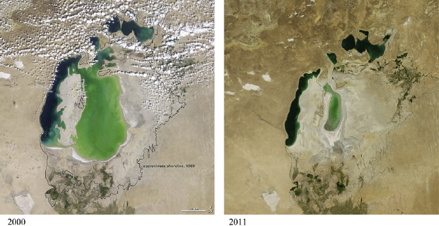
21st century desiccation of the Aral Sea: 2000 and 2011. Both are Moderate Resolution Imaging Spectroradiometer (MODIS) images captured aboard NASA's Terra satellite. The image on the left was captured on August 19, 2000, while the image on the right was captured on August 15, 2011. Both show the approximate extent, outlined in black, of the Aral Sea in 1960. Source: NASA Earth Observatory, 2011.
As former Soviet republics, each of the newly independent states within the region in essence began statehood with very similar initial economic conditions, though with dissimilar natural resource endowments. In the nearly two decades since, these five states have embarked on markedly different paths of privatization, economic liberalization, and market orientation, which in part have resulted in sharp intra-regional divergences in terms of economic output and growth (Pomfret, 2006), as well as socio-economic development (White, 2009). Currently fairly wide disparities exist within Central Asia with respect to output, economic development, economic freedom, and (perhaps less so) perceived corruption (Table 1). Perhaps most striking are the regional disparities with respect to economic output as expressed in per capita, purchasing power parity terms (first column, Table 1). Kazakhstan, the regional heavyweight in this regard, has a per capita GDP well over double the regions second ranked state (Turkmenistan), and more than six times that of the lowest (Tajikistan). The world's 9th largest state in territory, Kazakhstan is incredibly well endowed with natural resources including uranium, copper, gold, natural gas, and in particular with respect to its economic output, petroleum. Kazakhstan also witnessed high, double digit economic growth rates during the 2005–08 period, largely the result of record high global oil prices and additions/improvements to export infrastructure. Tajikistan, small, mountainous, and not well resource-endowed (with the lone exception of water) was engulfed in a civil war for much of the 1990s and remains mired in poverty. Contentious neighbors Kyrgyzstan and Uzbekistan both with per capita GDPs below $2500, have their own economic challenges. Kyrgyzstan, small and only slightly less mountainous than Tajikistan, has similarly bleak natural resource endowments as its poverty-stricken southern neighbor, though does have sizeable gold deposits that have attracted significant foreign investment. Kyrgyzstan is also the only state of the region having been admitted to the World Trade Organization, a product of its vigorous pursuit of early economic reforms, though has been afflicted with political instability and multiple revolutions during the past decade. Populous Uzbekistan is one of the world's leading producers and exporters of raw unprocessed cotton, and has natural gas deposits, as well as gold and other minerals. Turkmenistan, largely desert and watered nearly entirely by the Kara Kum canal, has an economy dominated by its significant natural gas reserves and production, as well as also being a significant world producer and exporter of cotton.
Selected economic indicators, Central Asia.
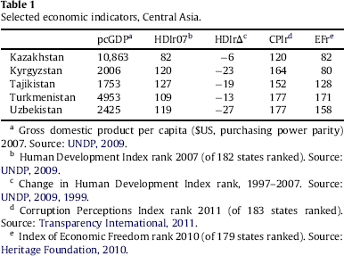
Selected economic indicators, Central Asia.
Gross domestic product per capita ($US, purchasing power parity) 2007. Source: UNDP, 2009.
Human Development Index rank 2007 (of 182 states ranked). Source: UNDP, 2009.
Change in Human Development Index rank, 1997–2007. Source: UNDP, 2009, 1999.
Corruption Perceptions Index rank 2011 (of 183 states ranked). Source: Transparency International, 2011.
Index of Economic Freedom rank 2010 (of 179 states ranked). Source: Heritage Foundation, 2010.
In a similar vein to intra-regional per capita output rankings, divergences also exist with respect to economic development (second column, Table 1). The UN's popular Human Development Index (HDI) ranks states based on indexed values based on per capita GDP, life expectancy, adult literacy, and school enrollment ratio, effectively broadening its focus to also include human health- and education-related variables. Over the past decade, each of the region's states has decreased its ranking vis-a-vis the rest of the world (column 3, Table 1), although Kazakhstan has dropped much less dramatically. It should be noted that the 1999 HDI (using 1997 data) ranked eight fewer (174 versus 182) states than did the 2009 edition, and each of the Central Asian states has been unable to maintain Soviet-era levels of investment in health care and education, especially so in the region's poorest states.
Central Asia has been referred to as one of the world's most corrupt regions (Åslund, 2003), and empirical data from Transparency International's Corruption Perceptions Index (CPI) seem to bear this out (column 4, Table 1). With the lone exception of Kazakhstan, each of the regions' states falls within the world's bottom seventh in perceived corruption rankings. Uzbekistan and Turkmenistan (the latter is tied with five other states one rank above the former) are ranked just above the world's most corrupt states of Chad, Iraq, Sudan, Myanmar, Afghanistan, and Somalia. This issue of corruption has particular resonance in the Aral Sea region, given its historical legacy (the Uzbek ‘cotton affair’ brought to light during the 1980s involved an intricate network of patronage and deceit, bilking the USSR of millions of rubles) and present concerns involving allocations of international funding assistance.
An additional illuminating way of examining the constituent economies of Central Asia is through a comparison of the multifaceted concept of economic freedom. The Heritage Foundation's most recent (2010) index of economic freedom (column 5, Table 1) ranks 179 world economies based on ten separate categories (including, among others, freedom from corruption, labor freedom, financial freedom, business freedom, and property rights). The region's most free economies, Kyrgyzstan and Kazakhstan, are classified in this index as ‘moderately free,’ while Tajikistan is categorized as ‘mostly unfree.’ Both Uzbekistan and Turkmenistan fall within the ‘repressed’ category, two of only 36 economies so categorized. The general lack of economic freedom, that is to say, the inability of individuals to make their own economic decisions, becomes important in the subsequent discussion of cotton, in particular with respect to Uzbekistan and Turkmenistan, the region's largest cotton producers. Individual property rights are extremely weak in Uzbekistan (Spechler, Bektemirov, Chepel, & Suvankulov, 2004), and almost completely nonexistent in Turkmenistan (Repkine, 2004). Furthermore, each of these states retains aspects of the Soviet central planning model, where output is directed by the central state authorities. In Uzbekistan, the state continues to mandate the cotton and wheat agricultural sectors (Pomfret, 2006), while in Turkmenistan nearly every economic sector remains under central government (i.e. presidential) control.
Each of the national economies within Central Asia are strongly oriented to the primary sector (extractive industries and agriculture), arguably that subset of economic activity most closely tied to the natural, physical environment (nature). In addition, economic activity (and in fact human survival) heavily depends on the region's water resources. Irrigated agriculture, for instance, forms a sizeable proportion of state gross domestic product within Central Asia, accounting for 39 percent of all economic output in Kyrgyzstan, 35 percent in Uzbekistan, 25 percent in Turkmenistan, 23 percent in Tajikistan, and eight percent in Kazakhstan (Weinthal, 2006). With respect to the immediate Aral Sea region, irrigated agriculture's contribution to economic output is even greater, particularly in Kazakhstan. A number of agricultural crops are grown within the Aral region, including wheat, rice, various fruits and other foodstuffs, though the dominant (in terms of overall impact on the region – both societal and natural environmental) crop in the region is most certainly cotton, having attained monoculture status during the Soviet period, and referred to in many contexts as ‘white gold.’
As previously discussed, Soviet Central Asia, watered by the Amu Dary and Syr Darya rivers, became the primary source of cotton of the USSR. The economic benefits (at least in the relative short term) became clear as the Soviet state became among the world leaders in cotton production. In general, such production needed, particularly as sown and harvested in the Soviet Union, a number of inputs (in addition of course to land and labor) including water, fertilizer, herbicides, pesticides, and defoliants. As the central push for increased production of cotton emanated from Moscow, an increase in irrigated land and the increase of application of the various inputs resulted, culminating in what, by the late 20th century, an unsustainable endeavor. The natural environmental devastation associated with the desiccating Aral Sea region, and the associated socio-economic negative externalities show that natural environmental costs of cotton production in this arid region were not viewed as important in the Soviet cost-benefit analysis of large scale cotton production.
Today, the region remains a leader in global cotton production and exports. Based on the most recent data (USDA, 2011), Uzbekistan ranks 7th in the world in terms of cotton production, and 5th in terms of cotton exports. Turkmenistan is the next important cotton state in the region, ranking 8th in the world in production and 6th in terms of exports. Tajikistan (17th globally in production, 11th in exports) and Kazakhstan (22nd in production, 15th in exports) are also important in the world cotton market, while Kyrgyzstan is not currently a major global presence in this regard, ranking 38th in production and 30th in exports. As a result, the cotton industry represents a vital source of export revenue, particularly for Uzbekistan and Turkmenistan. As structured in Central Asia, the industry is also highly labor intensive and provides a source of much needed employment in rural areas where other such opportunities are scarce. Despite these benefits of the cotton industry to the states of the Aral Sea region, many now view the various costs of cotton production (again as currently practiced in the region) as far exceeding the benefits (ICG, 2005; Spoor, 1993). The negative impacts of Central Asia's cotton industry on the region's natural environment are perhaps most dramatic, at the extreme manifested in the shrinking of the Aral Sea itself, as well as the destruction of the ecosystems associated with the sea and the riparian deltaic habitats. Though a scarce resource, water is largely free, resulting in no incentives to conserve this precious resource and no incentives to improve the efficiency of irrigation infrastructure (Spoor, 1993).
Economic concerns emanate as well, given the primacy of a primary commodity with wide historical price fluctuations. Within the region's three major cotton exporters (Uzbekistan, Turkmenistan, and Tajikistan), state procurement prices are set artificially low (much lower than the global market price), and in turn this cotton is exported at the higher world market price (ICG, 2005). As the state sets raw cotton prices, mandates production targets, subsidizes domestic production by providing ‘free’ water (Weinthal, 2006), and in fact dictates what farmers can grow (primarily cotton in the Aral region), farmers remain entrenched within a cycle of poverty. Labor intensive harvesting is also wrought with drawbacks as low wages and what amounts to forced labor prevail during the fall cotton harvests. Particularly in Uzbekistan, the use of school children in the cotton fields (a holdover practice from the Soviet period) continues today. It is estimated that up to half of the cotton produced in Uzbekistan is harvested by the 450,000 children annually sent to the cotton fields, leading many to urge an international boycott of Uzbek cotton (Saidazimova, 2007).
International medical health professionals working in the Aral Sea region have stated that here, “the level of health and the quality of life is profoundly poor and deteriorating further” (Small, van der Meer, & Upshur, 2001, p. 549). An examination of the region's human health conditions should begin with a recognition of the ties between human health and the health of a given ecosystem, of which, of course, humans are one constituent specie. In general, the poor overall health conditions among the Aral region's populations can be viewed as a direct result of the Aral Sea crisis' ecological devastation, an indirect result of unemployment and poverty associated with economic collapse, and additionally as a result of the collapse of the Soviet health care system and the inability of the newly independent states in the region to maintain this system and its coverage.
More specific causes of human health problems in the Aral Sea region revolve around the increased salinity and mineralization of water supplies, as well as the continued use and presence of agricultural chemicals. Inefficient irrigation practices, which continue today, have resulted in the raising of water tables, water saturating formerly productive agricultural land, and increasing the salt and mineral content of the region's water. In addition, the heavy application of fertilizers, herbicides, pesticides, and defoliants on cotton fields has resulted in these chemicals persisting in the ecosystem and food chain, washing downstream and concentrating in the immediate Aral Sea region.
Soviet application of these agricultural chemicals was heavy and intense. Between 1980 and 1992, pesticides (primarily dichlorodiphenyltrichloroethane, or DDT and lindane) were applied to cotton fields at a rate of 54 kilograms per hectare in Uzbekistan and 72 kilograms per hectare in Karakalpakistan. During the same period, the rate of such application in Russia was 4 kilograms per hectare and in the United States 1.6 kilograms per hectare (Ataniyazova, 2003). Further upstream along the Amu Darya in Tajikistan, Soviet journalists observed in 1983 aerial application of defoliant on cotton fields while school children were picking cotton (Feshbach & Friendly, 1992). Perhaps most alarming is the heightened and widespread presence in the Aral Sea region today of what has been called “the most toxic dioxin” (Ataniyazova, Baumann, et al., 2001, p. 806), the substance 2,3,7,8-Tetrachlorodibenzo-p-Dioxin (TCDD). TCDD is classified as a known human carcinogen and gained notoriety as an active element of the defoliant Agent Orange used during the Vietnam War (US Department of Health and Human Services, 2005). Concentrations of TCDD within the Aral Sea region today represent some of the highest documented to date in the world (Ataniyazova, Adrian, et al., 2001). Very high concentrations of TCDD have even been detected in mother's milk within human populations in the Kyzlorda oblast of Kazakhstan and in Uzbekistan's Karakalpakistan republic (Ataniyazova, Baumann, et al., 2001).
Human populations within the Aral Sea region face an onslaught of exposure to these salts, heavy metals, and chemical toxins through the air they breathe, the water they drink, and the food they ingest. Within Turkmenistan's Dashaguz oblast, for instance, airborne dust is deposited at a rate among the world's highest, and it has been found that this dust is heavily laden with pesticides (O'Hara, Wiggs, Mamedov, Davidson, & Hubbard, 2000). In Karakalpakistan, respiratory diseases are rampant and increasing (Wiggs et al., 2003). Access to safe drinking water is an additional problem. Within Karakalpakistan, 70 percent of tested drinking water fell short of acceptable chemical standards, and approximately 30 percent had excessive biological content, in particular sewage contamination (Small, Falzon, van der Meer, & Ford, 2003). Compounding human exposure is a contaminated food supply, particularly (though not entirely) foods of animal origin such as meat, milk, and eggs. As a result, dietary dioxin intake for a typical Karakalpakistan inhabitant is nearly three times higher than what the World Health Organization deems safe (Muntean et al., 2003).
Particular attention has been focused on the increase in diseases among the Aral Sea region's children, a vulnerable demographic cohort forming the region's future stock of human capital. Much of this increase has been directly linked to the region's declining ecological health (Kaneko et al., 2002). Infant mortality rates in the region today are high, exceeding 100 infant deaths per 1000 live births in many locations (Wiggs et al., 2003). This figure places the Aral region among the world's highest rates of infant mortality, exceeded by only a few states in sub-Saharan Africa. The litany of health problems faced by the region's children is striking. In addition to the concentrations of TCDD in human breast milk mentioned above, infants have also been observed refusing their own mother's milk because of its elevated salt content (Franz & Fitzroy, 2006). In addition, concentrations of the heavy metals cadmium and lead have been shown to severely impair kidney function in the region's children (Kaneko et al., 2003), and elevated levels of the chemical compounds DDT and polychlorinated biphenyls (PCBs) have been found in their blood (Ataniyazova, Baumann, et al., 2001). Diseases on the increase in children include urolithiasis (kidney stones), chronic bronchitis, immune deficiency, atrophic gastritis, and anemia (Kaneko et al., 2002).
As with its children, the adult populations within the Aral Sea region are additionally plagued by poor health. Infectious respiratory diseases are a particular problem. This region exhibits the highest rates of tuberculosis (TB) within the entire former Soviet territory (Wiggs et al., 2003). While a TB outbreak is classified as an epidemic when more than 50 per 100,000 people are newly infected, within the Aral region rates of up to 265 per 100,000 have been documented (Small & Bunce, 2003). Heightened rates of multidrug-resistant TB have also been found (Cox et al., 2004). The region's populace additionally suffer in exceedingly high rates from anemia, both within the general population (Small & Bunce, 2003), and particularly among pregnant women (Ataniyazova, Baumann, et al., 2001). Further elevated disease incidences, including heart disease, kidney disease, hepatitis, hypertension, cancers, typhoid, dysentery, and diarrheal diseases, have also been identified (Micklin, 2007; Small et al., 2001, 2003).
Adding to the already overwhelming barrage of negative health consequences are the potential catastrophic dangers posed by what was once an island in the Aral Sea. Vozrozhdeniye (resurrection or rebirth) Island, once straddling the maritime border between Kazakhstan and Uzbekistan in the heart of the Aral, was the primary testing ground for the Soviet biological weapons program. First used for this purpose during the 1930s, the island at that time was a logical location for testing, a result of its geographical isolation surrounded by sparsely populated deserts, a hot dry climate, sparse vegetation, and searing summer sands all reducing the threat of diffusion of biological agents. As an island deep within the Aral Sea, the threat of diffusion by insects or other animals was also minimized (Bozheyeva, Kunakbayev, & Yeleukenov, 1999). Through its years of operation up to the Soviet collapse, the Vozrozhdeniye facilities tested the delivery and efficacy of such weapons grade biological agents as anthrax, smallpox, Venezuelan equine encephalitis, plague, and brucellosis (Cook & Woolf, 2002). Though the testing here ceased with the exodus of the Soviets in 1992, the resilience of these biological agents and their potential spread represents an additional health concern within the region. As the Aral Sea has receded, the former island is now part of a large peninsula extending from the south. Regional fauna freely move in and out of the area, and could spread any remaining biological organisms into neighboring human populations (Micklin & Aladin, 2008).
Political considerations
The larger Aral Sea crisis and management of the water resources of the Amu Darya and Syr Darya continue to have political ramifications within the region. With the dissolution of the Soviet Union, the Sea itself and management issues surrounding its feeder rivers shifted from a domestic issue controlled by Moscow to an international issue involving the region's five newly independent states. Today, salient links between the region's natural environment and human populations coalesce around the political issues of international conflict, interstate cooperation, and the emergence of ethnic nationalism within certain local populations.
Given the importance of water to the regional economy, the overall aridity of the region, and the trans-boundary nature of the major water sources, the existence of conflicts over water here is not surprising. Indeed, such disputes are most apt to occur in arid regions where (and when) the supply of water is insufficient to meet regional demand (Haftendorn, 2000). Within Central Asia these conditions, particularly in times of drought, form the basis of regional tensions (Spoor, 1998). Some have posited the likelihood of ‘water wars’ erupting between (or within) states over allocation of scarce water resources (see e.g. Starr, 1991 or Amery, 2002). Such a scenario is a genuine concern within Central Asia, in particular as the Aral Sea has been identified as one of four basins (Jordan, Nile, Tigris-Euphrates being the other) where the potential for ongoing disputes places it in the highest at-risk category (Yoffe, Wolf, & Giordano, 2003).
Central Asia's physical geography and relatively recently imposed international political borders conspire to make tensions over water allocation almost inevitable. The region's water supply is generated in the mountainous upland areas of Kyrgyzstan and Tajikistan (upstream states), eventually flowing through the steppe and desert areas of southern Kazakhstan, Uzbekistan, and Turkmenistan (downstream states). A spatial discontinuity between water supply and water use persists within the region, as upstream states generate approximately 80 percent of Central Asia's water, though use only 16 percent. Conversely, the region's downstream states supply roughly 12 percent of the region's water while using 82 percent (Micklin, 2002). While conflicts have materialized between nearly all the region's riparian pairs, two conflict case examples elucidate the particular dynamics inherent in water disputes within the region.
The first conflict instance involves the ongoing dispute between the upstream state of Tajikistan and downstream Uzbekistan over the Roghun Dam project, intermittently under construction since the Soviet period and a particular source of contention between the two neighbors. Located on the Vakhsh River tributary of the Amu Darya, the completed dam will be the world's tallest (335 m high, 1500 m wide) containing a 17 billion square meter reservoir (Trilling, 2009). Disagreements over the dam's construction have persisted, with Uzbekistan actively seeking to stall the project. The finished dam would allow Tajikistan to control downstream flow of the Amu Darya, water vital for Uzbekistan's economy and what the state considers its national security. In March 2010, Tajik officials filed an official note of protest over the case of some 1000 rail freight cars bound for Tajikistan being indefinitely detained in Uzbekistan territory. Tajik officials claimed this action was meant to delay construction of the Roghun Dam, as much of the cargo was cement and other building materials bound for this project. Uzbekistan officials maintained that the freight sequestration was necessary in order to fulfill a recent agreement with NATO to allow supply shipments into Afghanistan from the north (Kanagatuly, Sikorskaya, Tokbaeva, & Olimova, 2010). For Tajikistan, the dam is expected to annually generate 3600 MW of electricity, enough to provide both a domestic supply of power and a much needed source of export earnings (Trilling, 2009).
An additional water-related dispute within the Aral Sea region is ongoing between Uzbekistan and Turkmenistan, two downstream states, over the latter state's Kara Kum Canal. This massive unlined irrigation ditch diverts Amu Darya water northwest through the length of Turkmenistan, running nearly to the Caspian Sea. For this largely desert state, the Kara Kum Canal (having been in existence since the Stalin era) represents a lifeline, supplying water for irrigation of its arid territory and providing water to its capital Ashgabad and other cities. Turkmenistan has announced plans to lengthen the canal and to expand irrigation in the near future (Micklin, 2002). Uzbekistan views the artificial canal as robbing its Karakalpakistan autonomous republic of water, and as being a major contributor to the desiccation of the Aral Sea (Micklin, 2002). The overall acrimonious feelings of Karakalpakistan residents toward Turkmenistan over Kara Kum Canal water diversion was anecdotally substantiated by the author's discussion with Nukus (capital of Karakalpakistan) residents during a trip to the area in summer of 2007.
Of additional concern to Uzbekistan is the ongoing construction (since 2000) of Turkmenistan's Lake of the Golden Century, an artificial water body being designed to fill much of a 3500–4000 square km depression in the northwest Kara Kum desert (International Crisis Group, 2002). Turkmenistan claims the lake will be filled by excess irrigation water and will not be maintained by the Kara Kum Canal or Amu Darya River. Uzbekistan is highly skeptical (as are others) that the lake will be solely maintained by irrigation runoff, and fears an increase in Turkmen water withdrawals. One additional point of contention between the two states, of particular pertinence of this paper's focus, are the large number of ethnic Uzbeks (approximately 1 million) living in the Dashaguz oblast who would be dislocated by the lake once construction is complete (International Crisis Group, 2002).
The conflict cases highlighted above are ongoing along the Amu Darya River, with disputes between downstream states, and an upstream and downstream state. The Syr Darya basin has also had its share of disputes over water, particularly between Uzbekistan and Kyrgyzstan over the latter's Toktogul reservoir and desire to increase its production of hydro power (Weinthal, 2006). Nor have the region's two upstream states been immune to water conflicts. In 2008 an international border incident occurred between Tajikistan and Kyrgyzstan over access to irrigation water and uncertainty with respect to precise boundary delimitation (Kadykeev & Majidova, 2008).
While interstate water disputes persist in Central Asia the successful joint management of water resources to date has stimulated hope for continued regional cooperation. The absence of armed conflict over regional water has been considered an indication of successful, peaceful cooperation. In a 2007 conference commemorating the fifteenth anniversary of the ICWC's formation, Loic Fauchon, president of the World Water Council, prepared remarks lauding regional interstate efforts (Dukhovny, 2007, p. 1):
“There are more than 260 transboundary basins in the world. But very few examples where five states are working together, hand-in-hand. Five States that are not only dealing with planning and negotiation but also with day-to-day management and functioning of two weighty rivers: the Amudarya and the Syrdarya. Their fruitful collaboration is the proof that, even if shared water resources can generate divergences and even conflicts, they are also a chance and a vector for collaboration between States and enables to overcome obstacles.”
The outlook for future cooperation may very well be positive as the five states have a history of unity in water management since the Soviet period, and the absolute necessity of such collaboration is clear to all involved (Micklin, 2002). In fact, cooperative action in regional water management is deemed necessary for the region's future security and socio-economic well being (McKinney, 2004). As unique historical and political nuances are key to the emergence of conflict or cooperation among basin states (Giordano, Giordano, & Wolf, 2002), the Aral Sea region's history of peaceful joint management of its water resources may bode well for future cooperation.
The Aral Sea crisis additionally impacts the region's political scene through what Hanks (2000) refers to as “environmental nationalism” (p. 949). This notion, as applied to the Karakalpak ethnicity and the autonomous region of Karakalpakistan (within Uzbekistan), essentially amounts to a centripetal force uniting the Karakalpak ethnic group. That is, the Aral Sea crisis and its concomitant ecological and economic devastation, combined with the disastrous health impacts facing the immediate region, may very well unite the Karakalpaks, producing feelings of nationalism. The crisis itself, having been the product of decisions made by ‘outsiders’ from Moscow (during the Soviet period) and Tashkent (since independence) can be viewed as a perfect prescription for nationalistic feelings among local Karakalpak residents (Critchlow, 1991). The Aral crisis and its overall disastrous impact on the region has, at least in part, resulted in the formation of Karakalpak separatist movements, Khalk Mapi formed in the 1980s, and more recently the nebulous Free Karakalpakistan movement (Saidazimova, 2008). Lines of similarity have been drawn between Karakalpakistan separatist sentiments and those within Xinjiang and Tibet in China and the Caucasus' South Ossetia (Sharipzhan, 2008), though much less international attention has been given the Karakalpak situation. Regardless, the central government in Tashkent has been active, at times brutally, in suppressing any such nationalist tendencies within Uzbekistan. Some claim that natural resource endowments, as well as perceived oil and gas deposits within the Autonomous Republic would enable an independent Karakalpakistan to survive (Shenker, 2009). In the foreseeable future, however, independence for Karakalpakistan seems highly unlikely, particularly given the ecological, social, and economic devastation wrought by the Aral Sea crisis (Hanks, 2000). One of the very pillars of Karakalpak nationalism, the misery (economic underdevelopment, negative human health effects) associated with the Aral Sea disaster, ironically puts any consideration of independence for the republic in serious doubt.
Dimensional interrelationships
The previous discussion brought to light many elements of the nature–society interrelationships operating today within the Aral Sea region. For ease of presentation, these links were organized into those existent within the regional economy, human health, and political dimensions. While presented individually, each of these spheres, and importantly the nature–society interrelationships operating within them, are also closely linked and themselves very much interrelated (Fig. 3). Presented here is a diagrammatic representation of the three spheres (regional economy, human health, and political issues), selected elements of the interrelationship between nature (N) and society (S) within each, and the further interrelationships between these dimensions.
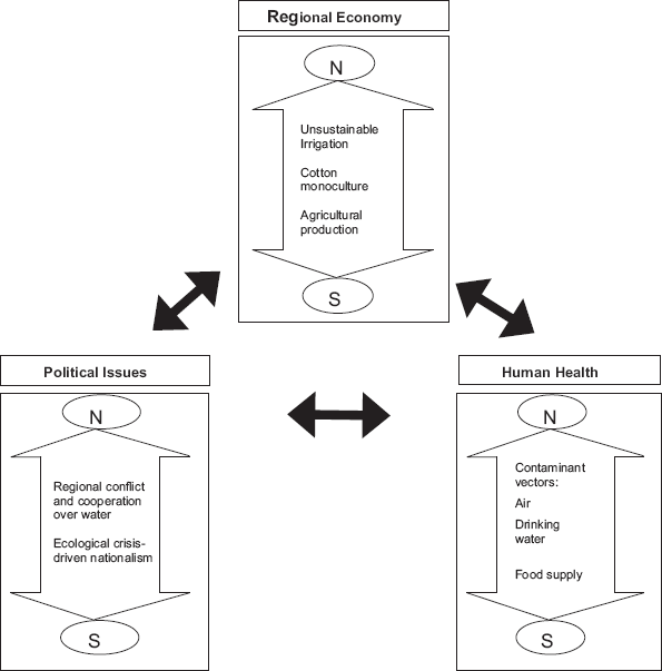
Dimensional interrelationships in the Aral Sea region.
Contemporary regional economic factors clearly impact both human health and political considerations within the region (i.e. unidirectional arrows emanating from the regional economy dimension in Fig. 3). Manifestations of the former include the continued salinization of water supplies (and soils) stemming from the inefficient irrigation systems in place, as well as the continued prevalence of agricultural chemicals within the region. Each of these owes its origin to the economic pursuit of cotton. With respect to the latter (economic influence on political considerations within the region), the very impetus of interstate political conflict over water stems from the economic importance of the rivers, in addition to the competing uses for them.
Political considerations impact fairly clearly both human health and the regional economy in the Aral region. With respect to the former, the newly independent states seem unable to provide adequate health care, particularly within the rural Aral Sea region. Health infrastructure is woefully inadequate, and this population's overall health seems not to be a political priority. The decline of the overall health care system in each of the regional states after the collapse of the Soviet Union might also fit in here. Direct links to the latter (regional economy) primarily result from state (particularly in Turkmenistan, Uzbekistan, and Tajikistan) control, quotas, and subsidies in the cotton sector. In addition, successful interstate cooperation over the region's water is essential for the functioning of the regional economy.
Human health conditions within the Aral Sea region have repercussive impacts on both the regional economy and its political scene. Poor regional health, of course, negatively affects human capital stocks, and anecdotal evidence of out-migration leaves the most vulnerable population cohorts (i.e. those less equipped to be able to improve their situation) behind. The miserable human health conditions within the region, in conjunction with the ecological devastation, can, and has, contributed to nationalist sentiments and, in the case of Karakalpakistan, regional secessionist movements.
Within the Aral Sea region today, close nature–society linkages exist within each of the additionally interrelated three spheres discussed above (regional economy, political considerations, and human health). In this way the region's human inhabitants and the natural, physical environment can be viewed as a coupled human–environment system, as expressed, for instance, by Turner et al. (2003). Others (e.g. Liu et al., 2007; Monticino, Acevedo, Callicott, Cogdill, & Lindquist, 2007) refer to such systems as coupled human and natural systems, or even coupled human-biophysical systems (e.g. Kotchen & Young, 2007). In an oft-cited work illuminating complexities in coupled human-environment systems, Liu et al. (2007) identify a number of elements common to a wide array of such systematic couplings. Among these directly applicable to the Aral Sea region include reciprocal effects, feedback loops, human-aided resilience, and legacy effects.
Reciprocity and negative feedback abounds in today's Aral Sea region. At the most general level, human action (intensive, unsustainable irrigation practices) has been a dominant driver of the destruction of the Aral Sea and its natural ecosystems. In a reciprocal negative feedback loop, this ecosystem destruction has endangered the lives (and livelihoods) of people living in the region. Diminished ecosystem services, desiccation and desertification, contaminated air, water, and food chain, all significantly contribute to poor human health in the region. Other diseases owe their origin to widespread poverty of the region, resulting from the disappearing sea and its commercial fishing resource. Perhaps most dramatically, the widespread (and ongoing) large scale application of fertilizers, herbicides, pesticides, and defoliants has resulted in the concentration of toxic substances in the Aral Sea region, amounting to a poisonous assault on local populations through airborne chemical-laden dust, tainted water sources, and contaminated food supply. Showing additional reciprocity and negative feedback, the economic importance and political necessity of the cotton industry, largely contributing to the Aral Sea crisis, exhibits decreasing returns to scale as yields decrease with increasing inputs, making a major causative factor in the Aral crisis ultimately unsustainable.
The resilience of the northern, Little Aral (its recent stabilization, apparent return of commercial fish species, and improved climatic moderation function) has only been enabled through massive human intervention. World Bank funding, Kazakhstan government implementation, and large scale dam and dyke construction projects reminiscent of the Stalin-era remodeling of nature have made the ‘return’ of the Little Aral possible. Micklin (2007) presents a multifaceted mitigating solution to at least stabilize what remains of the Aral Sea, particularly the larger, southern portion. This rehabilitation effort, on a much larger scale than that which stabilized the northern portion, would also require substantial human intervention, including construction of a complex of dykes, dams, spillways, and cement-lined canals. The resilience of the Aral Sea, indeed its continued survival, will require substantial human modifications of the natural (though greatly transformed by human action) environment. Somewhat ironic is the fact that large-scale human modifications of the natural environment (Soviet-era irrigation construction projects) largely contributed to the desiccation of the Aral Sea, and now (as outlined by Micklin (2007)) are viewed as its only realistically feasible salvation.
Legacy effects, those previous human–environment interrelationships whose impacts are felt in subsequent years, are additionally important elements of the Aral Sea crisis. The Soviet efforts in drastically expanding irrigation networks throughout the region following World War II did not immediately, of course, show discernable negative repercussions for the Aral Sea. In what Glantz (1999) refers to as creeping environmental problems, these repercussions, including the recession of the sea, diminished water quality, and other environmental ills, didn't become evident for decades. Today, Soviet practices, especially in the cotton sector, continue within the downstream republics of Uzbekistan and Turkmenistan. In these instances, cotton is a major export revenue generator, and each government centrally sets production quotas and artificially low procurement prices. Inefficient irrigation infrastructures continue to waste water, and associated reductions in soil quality force more and more applications of agricultural chemicals and expansions in irrigated acreage. Planned expansion of the Kara Kum canal and completion of Lake of the Golden Century in Turkmenistan, combined with planned expansion of irrigation in Uzbekistan cast serious doubt on any future short-term savings of water (a key component, incidentally, of the Micklin (2007) Aral Sea rehabilitation plan).
The above discussion has attempted to situate the Aral Sea crisis within the framework of the nascent coupled human–environment system (or coupled human and natural systems) analytical framework. The notion that an interconnected relationship exists in the Aral Sea region, of course, is not new. What Postel (2000) (whose quote opened this paper) so aptly noted a decade ago remains true, and perhaps of greater consequence, today. The Aral Sea crisis is indeed a most dramatic case, demonstrative of the interrelationships between the region's natural environmental integrity and the well-being of its populace. The nature–society linkages discussed in this paper have, in part, attempted to substantiate this point. Natural environmental elements in the Aral Sea region include the now-fragmented sea itself, water (in the sea, the feeder rivers, and groundwater), air, cotton (though with significant human inputs and modifications), and the surrounding desert and steppe environments. Human elements include the population, economic components including primary sector dominance (agriculture) and irrigation infrastructure, and political actors and processes. Elements of the human–environment interrelationship include the Aral Sea's desiccation, its lost climatic moderation function, contaminated dust, agricultural chemical-laden air, salinated and poisoned water supply, desertification, political and economic impetuses for the ensconced cotton industry, and the desert's high temperatures and aridity constraining human activity.
A full understanding, recognition, or appreciation of the complexities of these human–environment interrelationships, by policy makers, international donor agencies, or local residents, has not always been apparent. With such a coupled, multi-element system, valuations and cost-benefit analyses are necessary and tradeoffs are inevitable. As the Aral Sea continues its retreat and the health of the immediate region's populations continues to worsen, decision making to date has failed to assign valuations to ensure natural environmental and social sustainability within the immediate Aral Sea region. In a strong criticism of the World Bank and its funding initiatives within the region, Small and Bunce (2003) argue convincingly that this international funding agency has failed, most notably in its neglect to focus efforts aimed at reform of agricultural production and the related inefficient irrigation practices (it would seem primarily within Uzbekistan and Turkmenistan). In other words, the World Bank has failed to target a primary anthropogenic driver of the entire Aral Sea disaster. The neglect of this essential link cannot be blamed solely on the World Bank (or other international donors) as the political will within the region's largest cotton producers, cotton exporters, and water consumers (Uzbekistan and Turkmenistan), to reform the agricultural production sector, is glaringly absent (Weinthal, 2001).
It should be noted here that the five now independent states in Central Asia share a number of contemporary challenges. Landlocked and distant from major world markets, the region's situation is not ideal for global trade. The inherited Soviet legacy, including ill-advised political boundaries (particularly in the Ferghana Valley), command economy structures, the woefully inefficient irrigation networks, and holdover vested political interests, makes a transition to market orientation (to say nothing of democratization), is a genuine challenge. Rapid population growth in southern Kazakhstan and the Ferghana Valley portions of Uzbekistan, Kyrgyzstan, and Tajikistan make regional food security a pressing issue. Recent political instability in Kyrgyzstan (revolutions in 2005 and 2010, June 2010 ethnic violence in the southern Osh region) has struck a palpable chord of fear within the political structures of each of Kyrgyzstan's neighbors that such instability and violence could potentially spread across tenuous international borders.
Conclusion
This paper's purpose has been to elucidate the variety, specificity, and directionality of nature–society linkages operating within the Aral Sea region of Central Asia. Particular emphasis has been placed on the contemporary human–environment interrelationships which, in essence, form a coupled human–environment system. The inextricably linked nature of this system necessitates knowledge and understanding of these interactions on the part of policy makers within the region, as well as international donor agencies wishing to positively address the decades-long Aral Sea crisis. Of particular urgent need is reform of a major anthropogenic driver of the Aral Sea disaster; agricultural production (particularly cotton) and the unsustainable irrigation practices anchoring this economic sector. Such reform would also need to target the political and economic factors promulgating the large scale production of cotton, particularly in Uzbekistan and Turkmenistan.
The recent stabilization of the northern, Little Aral in Kazakhstan offers a flickering glimmer of hope, optimism that Micklin (2007) has engendered in a plan to restore the larger, southern portion of the Aral Sea. Similar to those which were successful in ‘saving’ Kazakhstan's Little Aral, the Micklin plan would require herculean human intervention unseen within the region since Stalin's ‘remodeling of nature.’ Nature–society linkages would also need to be addressed, in particular the unsustainable withdrawals of water from the Amu Darya and Syr Darya Rivers.
Aside from being of academic interest to geographers and others engaged within the burgeoning human–environment coupled system research arena, the issues and implications raised in this paper have unmistakable resonance for the human inhabitants and ecological resilience of the immediate Aral Sea region. Clearly as well, the various interrelationships discussed here have salient resonance for those concerned with the political developments and socio-economic development issues within the larger Central Asia region. Furthermore, as Aral Sea dust is carried into Russia and China, as fears of remnant Soviet-era biological weapon agents exist, and as water scarcity and food insecurity fan political unrest, the issues highlighted here have global significance as well.
For the people of Kyzlorda oblast (Kazakhstan), Dashaguz oblast (Turkmenistan), and particularly the autonomous republic of Karakalpakistan (Uzbekistan), the Aral Sea crisis represents much more than an isolated photograph of a rusting desert-bound vessel appearing in an introductory geography or environmental studies textbook. For these people, the crisis has meant a destruction of their economic livelihoods as well as an unwelcomed assault on their health conditions. The ecological tragedy of the Aral Sea is well known and oft-studied. The human tragedy, perhaps a bit less known and studied, seems equally as ominous. The massive human transformations and alterations that created the crisis are ironically the very anthropogenic drivers that can save the Aral Sea. This paper, if nothing else, represents an impassioned call, emanating from a geographer based in the Central Asia region, for a reconsideration of the contemporary nature–society linkages inherent in the Aral Sea region. Clearly a value shift is in order, with ecological and local human condition values raised vis-à-vis the economic and political imperatives which have traditionally won out. The urgency is unmistakable – the Aral Sea region's ecological and social sustainability is at stake.