
Abstract
Mapping of Historic US Hookworm prevalence data from the Rockefeller Sanitary Commission (early 1900s) using current GIS (Geographic Information System) software (county shape files) illustrates the extremely high prevalence of hookworm disease (Uncariasis) in the Southeastern US at the time. Some counties in 7 states recorded 50% to 100% of the population with positive screens for hookworm in a monumental surveillance and treatment campaign. Narrative descriptions mentioned higher prevalence in “sand districts” vs. “clay districts”. In order to validate this description for historic data, further GIS databases (STATSGO) were used to classify and quantify the % acreage in Eastern North Carolina falling into moderately- to well-drained soil types. These were then mapped and compared with the historic prevalence data. Most severely infested counties had at least 50% moderately to well-drained soil. Further analysis on soil data for other states with “coastal plains” could provide more background information on Environmental conditions for hookworm prevalence and distribution in US history.
“Since history has no properly scientific value, its only purpose is educative. And if historians neglect to educate the public, if they fail to interest it intelligently in the past, then all their historical learning is valueless except in so far as it educates themselves”. Trevelyan, (1922).
Introduction
The first authoritative publication on the human hookworm parasite and disease in the US was a US Hygienic Laboratory Bulletin (No. 10) written in 1903.
1
It was titled “Report upon the prevalence and geographic distribution of hookworm disease in the United States”. Dr. Stiles writes that he was “convinced from theoretical deductions that hookworm disease (uncinariasis) must be more or less common in the South (of the US)”. He gained permission to travel from Washington DC to Ocala, Florida, sampling for the parasite at “penitentiaries, mines, farms, asylums, schools, and factories”, establishing that the anemia in the rural South was due to the hookworm parasite, but only in the “sand districts” and not the “clay districts” or cities. He also showed that a hookworm species,
Because the historic data was recorded by volunteer workers using non-standard methods, precise demographic data was not recorded and hookworm prevalence was derived by tallies of percent of population “treated” (those who had positive stool samples) by county in the eradication campaign. This epidemiological method is still common in studies of hookworm infection.3,4 Environmental data in the Stiles bulletin was observational, not measured or recorded systematically. Wilcox, 5 however, emphasizes the importance of narrative in the understanding of disease, past and present: “stories in this report describe selected US public health events from 1900 to 1932 and link these experiences to modern leadership challenges in public health policy”. Hookworm infection in the South in the early 20th century in the US was one of the historical disease narratives included, illustrating the impact of the government/private foundation/local volunteer coalition on the change in attitude, health and economy of rural residents in coastal counties as a result of this massive initiative. Thus the first aim of this paper could be its use in addressing current leadership challenges in public health policy from a more complete understanding of this historic data.
In addition, interest in the reemergence of infectious disease in locations where they have been absent, and in the use of historic data to form a background for current distribution comparisons is increasing. Finding possible environmental relationships using relatively constant soil characteristics in a previously endemic area was an additional impetus to the present investigation, where we use GIS mapping techniques and historic databases to present visual relationships of hookworm prevalence in the Southeastern US along with current GIS soil drainage characteristics of the same areas.
GIS databases are now commonly used to delineate distribution of infectious disease and disease vectors. Simon Brooker, 6 included GIS databases: normalized difference vegetation index (NDVI) and satellite-derived mean land surface temperature (LST) in hookworm distribution studies.7,8
Hookworm disease continues to debilitate humans in many parts of the world4,9,10 and GIS information assists in Integrated Pest Management (IPM) targeting of specific geographic areas for treatment. 11
Historic data for Virginia, West Virginia, North Carolina, South Carolina, Georgia, Alabama, Mississippi, Florida, Texas, and Arkansas, percent prevalence of hookworm infection in maps was derived from historic data collected and mapped with ArcGIS software by Eric Thoman. 12 For North Carolina this study details percent acreage of moderately- to well-drained soil for each coastal plain county, and compares those percentages to historical percentages of hookworm prevalence.
The limitations of these comparisons, such as using erratically recorded historical data for hookworm prevalence, converting paper and microfilm written data to a GIS database, and comparing these to current USGS soil characteristics databases are numerous. However, given the historic nature of the data, and the state of data collection at the time, neither the soil characteristics data nor the hookworm prevalence data could have been collected simultaneously, nor differently. The specific purpose of this paper is thus to describe the general historical data using contemporary mapping techniques, and to compare it to contemporary soil characteristics using similar mapping techniques. Giving life to historic data in this way can potentially aid in understanding infectious disease prevalence and its relation to geography in a location (the United States South) where the disease has been eradicated. It can also aid in understanding our social and medical history, and may shed light on the constancy of the environmental contribution of soil drainage factor characteristics in the epidemiology of this disease.
General global distribution of hookworm with reference to latitude (Fig. 1) is more recently recorded by percent prevalence in sections of continents and countries depending on data collection type (Fig. 2).
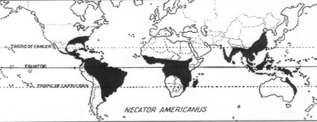
World-wide distribution of endemic hookworm
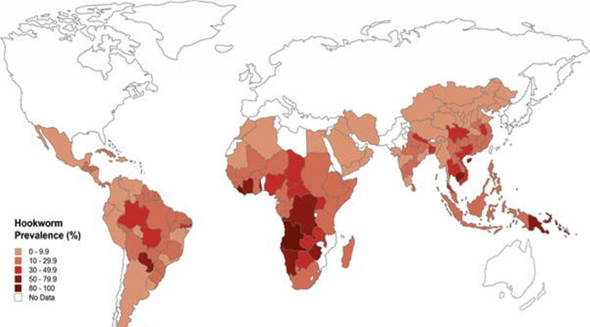
Hookworm prevalence, 2003, both species. (CDC).
Environmental and human behavioral conditions that co-occur with hookworm infections are such things as: moist, warm climates (tropics, subtropics and mines), human populations that defecate directly into soil, and not consistently wearing shoes.4,13,14 In the Middle East, North Africa and Southern Europe, the species that occurs is
Early evidence of an association between soil type and hookworm infestation levels was provided by studies in the Southern American States, reviewed in Brooker and Michael. 8 Recent confirmation of this association in other parts of the world has been provided by two studies in South Africa: Mabaso et al. 13 Found that high hookworm prevalence was significantly associated with well-drained sandy soil types whereas low prevalence was associated with clay soils; Saathoff et al. 16 Found that hookworm infection is positively associated with sandy soils, while controlling for other environmental factors and socio-economic and behavioral factors.
This retrospective study will investigate the relationship between historic hookworm infection data, recorded by a diverse group of government and specially hired individuals in the years 1910–1912 (the Rockefeller Sanitary Commission and others), and Statistical Geology Geographic Information System (STATSGO GIS) soil type maps in North Carolina, specifically maps of moderately- to well-drained soils in Eastern North Carolina Counties.
In current hookworm endemic areas in the world, reports typically describe infection with multiple intestinal parasites,3,4,7 with infection levels ranging from 25%–50% of the sample population (usually school age children). Levels of hookworm infection are often lower than other intestinal parasites. Species of hookworm parasites are not always differentiated in these studies15,17 because of financial, personnel, and infrastructure challenges in developing countries. More information on the interactions, distribution, epidemiology and environmental requirements of these and other parasites may soon be available as investigations continue.
Methods
Brooker et al 18 used the National Oceanographic and Atmospheric Administration-Advanced Very High Resolution Radiometer (NOAA-AVHRR) data to model human helminth distributions in Cameroon, West Africa in order to prioritize areas with heavy infestations for treatment and control. Other GIS techniques have been applied to hookworm population studies as well.19,20 One of the important uses of GIS is creating maps of distribution. In 2009 Eric Thoman, a scientist interested in reviving the historic hookworm prevalence data languishing in the archives of the Rockefeller Foundation archives in New York, spent several weeks converting numbers of reported hookworm cases in Southern US states and counties into GIS shape files (East Texas, Louisiana, Arkansas, Mississippi, Alabama, Georgia, South Carolina, North Carolina, Virginia, and West Virginia) Raw written and microfiche data were converted into percent prevalence based on the 1910 census data, and data was mapped data on ARC GIS. The percent prevalence of hookworm infestation in all the counties included in the Rockefeller Sanitary Commission's eradication campaign were derived from written records of treatment numbers from various dispensary locations. The extent of this campaign and the number of counties represented are surprisingly large.
In this study, Current Soil characteristics were mapped with US Geological Service STATSGO databases of soil drainage characteristics (Fig. 3). In order to compare percent moderately well drained and well-drained acreage amounts in eastern North Carolina counties to the percent infection rate for hookworm disease infection in these counties from 1911–1915, soil characteristic pixels in the STATSGO database (Fig. 8) were added together for well drained and moderately well drained sections to derive a percent acreage in these counties (Figs. 9 and 10).
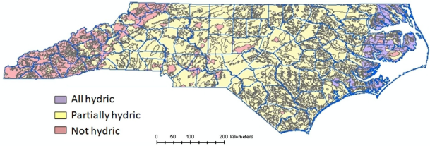
STATSGO soil characteristics layer for North Carolina, USA.
In coastal North Carolina counties, total moderately- to well-drained soil acreage was calculated as a percent of total acreage of the county by totaling pixel size and numbers from this database.
Results
The general prevalence in southern US counties in Figure 4 shows Hookworm disease distribution prevalence in four quartiles. Examples of individual state maps include Virginia (Fig. 5) South Carolina (Fig. 6) North Carolina (Fig. 7). Maps including county names for other states in the Southeast US can be found in Thoman. 12
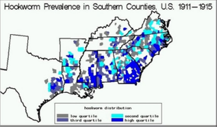
General hookworm distribution from Thoman 12 in the US South.
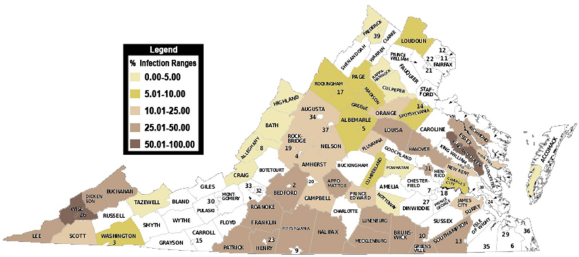
Distribution of hookworm infection in Virginia 1911–1915. 12
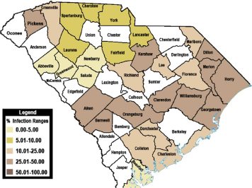
South Carolina hookworm distribution 1911–1915.
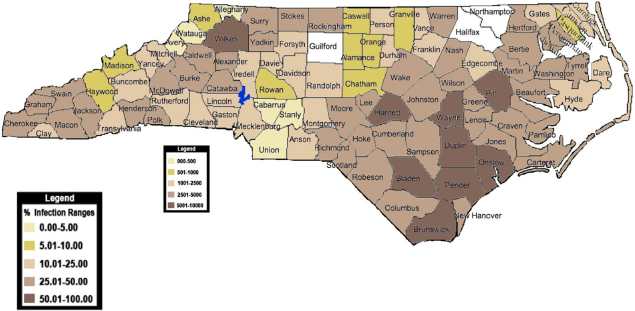
Hookworm prevalence in north Carolina 1911–1915.
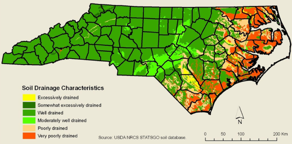
In order to measure soil drainage characteristics in E. North Carolina, the US Department of Agriculture (USDA) Natural Resource Conservation Service (NCRS) State Soil Geographics (STATSGO) soil database GIS layer was used.
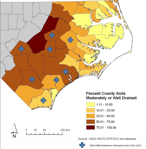
Eastern north Carolina counties with percent county soils moderately or well-drained. Plus marks indicate counties with 50%–100% hookworm infestation in 1911–1915. Most of the other counties had <25% infestation prevalence.
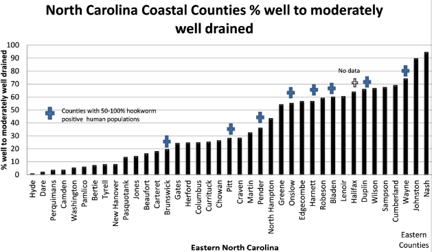
Range of moderately to well-drained soils in coastal North Carolina counties from lowest% acreage to highest% acreage placing 50% to 100% hookworm infestation counties at the higher end of % moderately to well-drained counties in the bar graph. Amounts of hookworm infection per county and percent amounts of well-drained and moderately well drained soil in that county were then compared.
As can be seen on the percent infection map for NC (Fig. 7) most of the counties in Eastern North Carolina had 25% to 100% prevalence of hookworm infection. Hyde, Dare, Camden, Pasquotank, Currituck, Gates and Edgecombe counties had >10 to 25% infection. Hyde, Dare, Camden, Pasquotank, and Gates also had >10 to 25% moderately to well drained soil. Currituck has more than 10 to 25% moderately well drained to well-drained soil. One possible explanation for the current soils drainage condition in Currituck Co. compared to the other Northern North Carolina Coastal Counties in this group is the impact of continuous development in Currituck Co. and the Drainage of the Dismal Swamp Canal, and agricultural drainage since 1805 when the canal was opened.
Other counties with poor drainage characteristics but 25%–50% infection are Tyrrel, Washington, and Bertie. In the Southern part of the state, New Hanover Co. has poor drainage, and is the only southern coastal county with less than 50% infestation.
An interesting feature that can be seen on the statewide drainage map is the remnant sand dunes in Bladen and Pender Counties. These extremely well or excessively well drained areas may have accounted for an extremely high infection level in those areas. Rainfall amounts and spacing also has an important effect on hookworm population dynamics. 16
Other social, cultural, economic, and environmental characteristics influence infection levels, as seen in recent studies and as mentioned in historical records. For example, human feces disposal methods, use of footwear, and sanitation in general affect transmission levels of hookworm populations.13,21 Much of the additional work of the Hookworm Eradication Sanitary Commission in the Western part of North Carolina during the 1913–1915 Campaign was to promote privies instead of random defecation on farms and fields. There was no systematic data on social, economic and environmental conditions collected in this campaign, however. During this time period the only “city” in Eastern N. Carolina (where hookworm infection was not common) was Wilmington in New Hanover Co. There are some demographic data for the 1910 census, and farm data, but this investigation did not include any of this historic data. The majority of this part o the state was rural subsistence farming.
Conclusion
A visual presentation of historic data collected during a Southern US hookworm eradication campaign in the early 20th century is helpful in understanding some of the importance of soil drainage characteristics on soil nematode habitat in North Carolina. Further calculations of soil drainage characteristics in other states, such as Virginia and South Carolina, Georgia, Alabama, and Mississippi might provide further evidence of soil drainage importance in historic hookworm distribution in the US. The current research findings that certain temperature averages, humidity averages, and soil drainage in coastal plains leads to high levels of hookworm infestation, especially in areas where “night soil” is applied to moist farm fields 22 and where the farmers wear only sandals, if any footwear, can be logically applied to the environmental conditions in the southern US in the early 20th century. Other sociological factors and environmental factors not systematically recorded in this early campaign against hookworm undoubtedly had important effects on the incidence of hookworm infection, however, with infection rates at 25% and above, and no specific geographic data from individual infected patients, pinpointing those differences at a meaningful level might be impossible.
An important recent translational research finding has shown that night soil (human feces) composted for only 3 months contained viable parasite eggs; authors recommended 6 months of composting before use. 23 Human feces disposal was undoubtedly a serious problem in all of the SE at this time, and composting not even considered, because increased outhouse use was part of the educational hookworm campaign. Another phenomenon that was observed in the US South was the habit of “dirt eating” especially in pregnant women. In Kenya this habit continues and adds to the helminth reinfection problem there. 24
Economic development in much of the SE United States, along with building adequate public health infrastructure in most states, has provided this part of the US with freedom from many diseases that were once endemic. The constant threats of natural disaster, human poverty, and translocation of immigrants with parasitic diseases25,26 can change this status quickly, however. Without constant surveillance and preparation by state and local health departments, a grisly lineup of vector borne and infectious diseases, including intestinal parasites, waits to re-emerge. Independent philanthropic organizations, such as the Rockefeller foundation of the early 20th century, and the Gates foundation today do not have the stamina to maintain constant public health protection, and are not equipped to develop sustainable monitoring of conditions nor sustainable anti-poverty programs. We endanger our lives with continued ignorance of the effects of poverty and lack of public health care. The Rockefeller industrialists, and the government of the US in 1910 wanted to improve the economy of the southern US with a campaign against hookworm disease, and in the process contributed to the development of a public health infrastructure that spread throughout the US. We are faced with rising costs for this protection, but need reminders such as that presented in this report, about the potential for disease re-emergence if the public health sector is debilitated through ignorance, and neglect.
Footnotes
This manuscript has been read and approved by all authors. This paper is unique and is not under consideration by any other publication and has not been published elsewhere. The authors and peer reviewers of this paper report no conflicts of interest. The authors confirm that they have permission to reproduce any copyrighted material.