
Abstract
On 6 February 2023, two earthquakes occurred approximately 9 h apart, with Mw 7.8 and 7.5, and epicenters located in Pazarcık and Elbistan districts of Kahramanmaras province, respectively. As part of a national project team which was funded by the Disaster and Emergency Management Presidency of Turkiye (AFAD) between June 2021 and June 2023, the authors of this article had proposed a framework to assess the seismic resilience of an urban region. The pilot area of this national project was a small-scale industrial town named Turkoglu located to the south of Kahramanmaras, at the intersection of Amanos and Pazarcik segments of the East Anatolian Fault zone. The proposed framework encompasses the assessment of active faults in the region, construction of regional velocity models, ground motion simulations of potential earthquakes, structural vulnerability, and study of seismic resilience indicators. The Pazarcik earthquake occurred 4 months before the end of the project on the exact fault system, which was modeled in ground motion simulations within the project in 2022. The objective of this article is multifold: first, to present our findings before the earthquake (2021–2022) in the region, including regional velocity models, ground motion simulations, street survey-based building classifications, and vulnerability classes; and second, to compare the after-event modeling of damage distributions in comparison with the observed damages as well as resilience evaluations of the region from multiple perspectives. A third objective is to assess the seismic resilience framework used in the project, as there are multiple seismically active areas in Turkiye and the world where similar large events are anticipated. This study constitutes a significant case study in the Turkoglu region, which involves critical evaluations of seismic resilience from before and after event data.
Keywords
Introduction
East Anatolian Fault Zone (EAFZ) is the second most active fault zone in Turkiye. Despite the historical activity along with the two recent major events near Elazig in 2010 and 2020, the majority of the studies involving seismic hazard, risk, and losses focus on the North Anatolian Fault Zone (NAFZ) which lies along the country in the East–West direction in the North (e.g. Altindal et al., 2021; Ansal et al., 2009; Askan et al., 2015; Durukal et al., 2005; Karimzadeh et al., 2018; Ozmen et al., 2020; Ugurhan and Askan, 2010; Ugurhan et al., 2011). This can be attributed to the fact that NAFZ contains industrial centers, dense populations, and Istanbul at the western end. Nevertheless, there are several studies on the assessment of seismic hazard along the EAFZ (e.g. Aktug et al., 2016; Duman and Emre, 2013; Gülerce et al., 2017; Gullu et al., 2008; Güvercin et al., 2022; Nalbant et al., 2002). A particular region surrounding the southern segments of the EAFZ is considered a major seismic gap due to lack of large events in the instrumental era (e.g. Nalbant et al., 2002). A recent study by Arslan Kelam et al. (2022), 1 year before the 2023 sequence, focused on seismic vulnerability through considerations of potential earthquakes in the Gaziantep region, which is located nearby this major seismic gap and was affected severely by the February 2023 sequence.
On 6 February 2023, two earthquakes occurred approximately 9 h apart, with Mw 7.8 and 7.5 (U.S. Geological Survey, 2023), and epicenters in Pazarcik and Elbistan districts of Kahramanmaras province, respectively. These events are among the largest earthquakes that have occurred in Turkiye since the 1939 Erzincan earthquake, causing extensive damage in 11 provinces and approximately 50,000 casualties. Both earthquakes exhibit a left-lateral slip mechanism. The first event caused a rupture of approximately 400 km in five separate segments of the Eastern Anatolian Fault zone. The second occurred further north, on a 200 km fault plane near Elbistan (Figure 1).
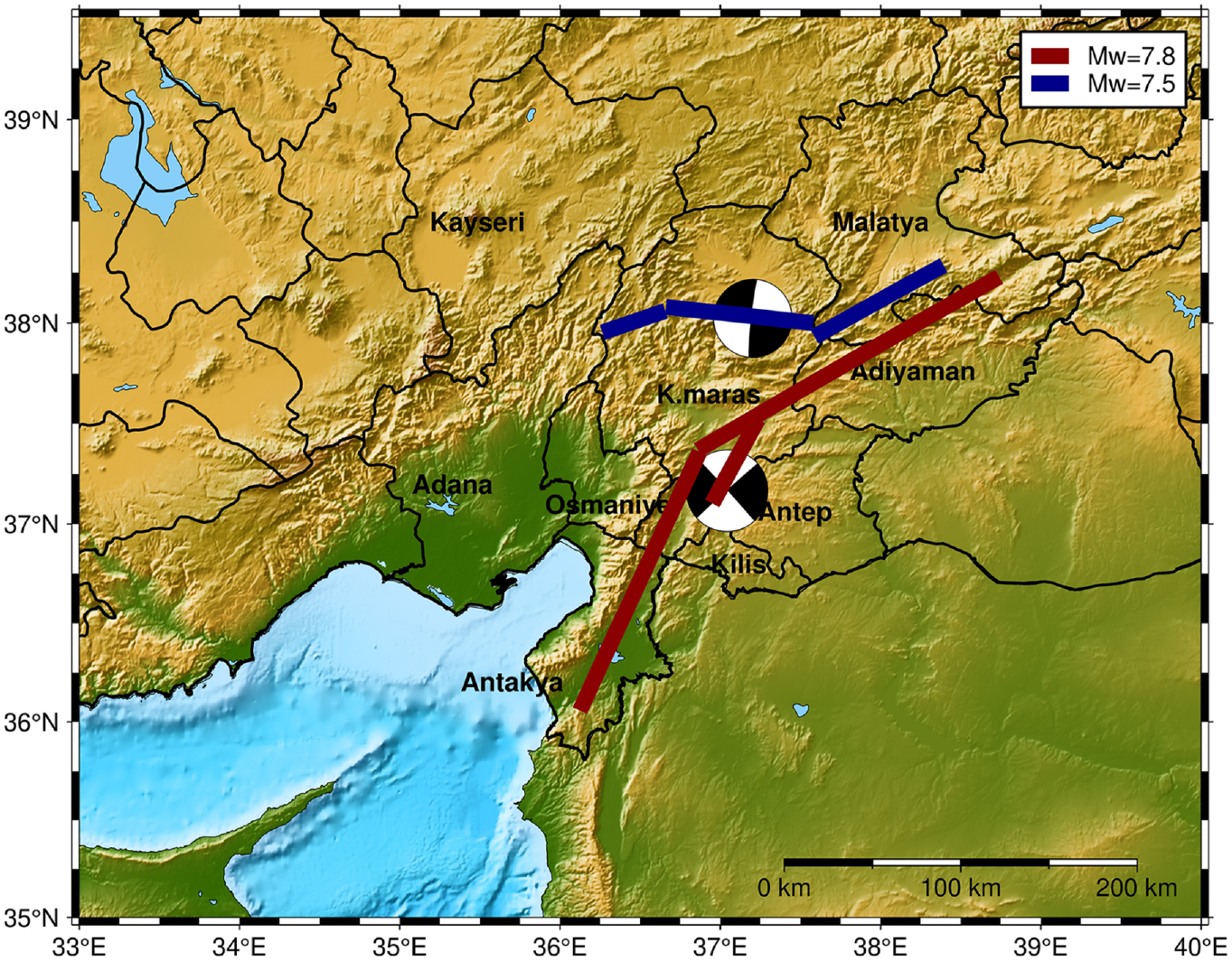
Locations of the fault planes, fault mechanisms, and moment magnitude (Mw) values according to U.S. Geological Survey (2023).
The first event yielded a very large near-field ground motion dataset, particularly along the fault plane, while the second one is much less densely monitored in the near-field. The distribution of peak and spectral ground motion parameters of the first earthquake is presented in Figure 2. The ground motions recorded at Disaster and Emergency Management Presidency of Turkiye (AFAD) strong motion stations (publicly available at https://tadas.afad.gov.tr/) are quite high in terms of both maximum acceleration and velocity values, as well as spectral accelerations. The short-period spectral accelerations exceeded 1.5 g and may have caused serious damage to the highly vulnerable residential building stock in the region. The long periods seem to be enhanced at softer soil sites and deep basin structures, particularly around Antakya, with predominant basin effects. At most stations, the design spectra for the 475-year return period are exceeded, which solely cannot explain the collapses in the region, yet it points out the extreme nature of these earthquakes. Regional seismic hazard analyses and detailed assessment of ground motions in comparison with empirical models can be found in Altindal and Askan (2024).
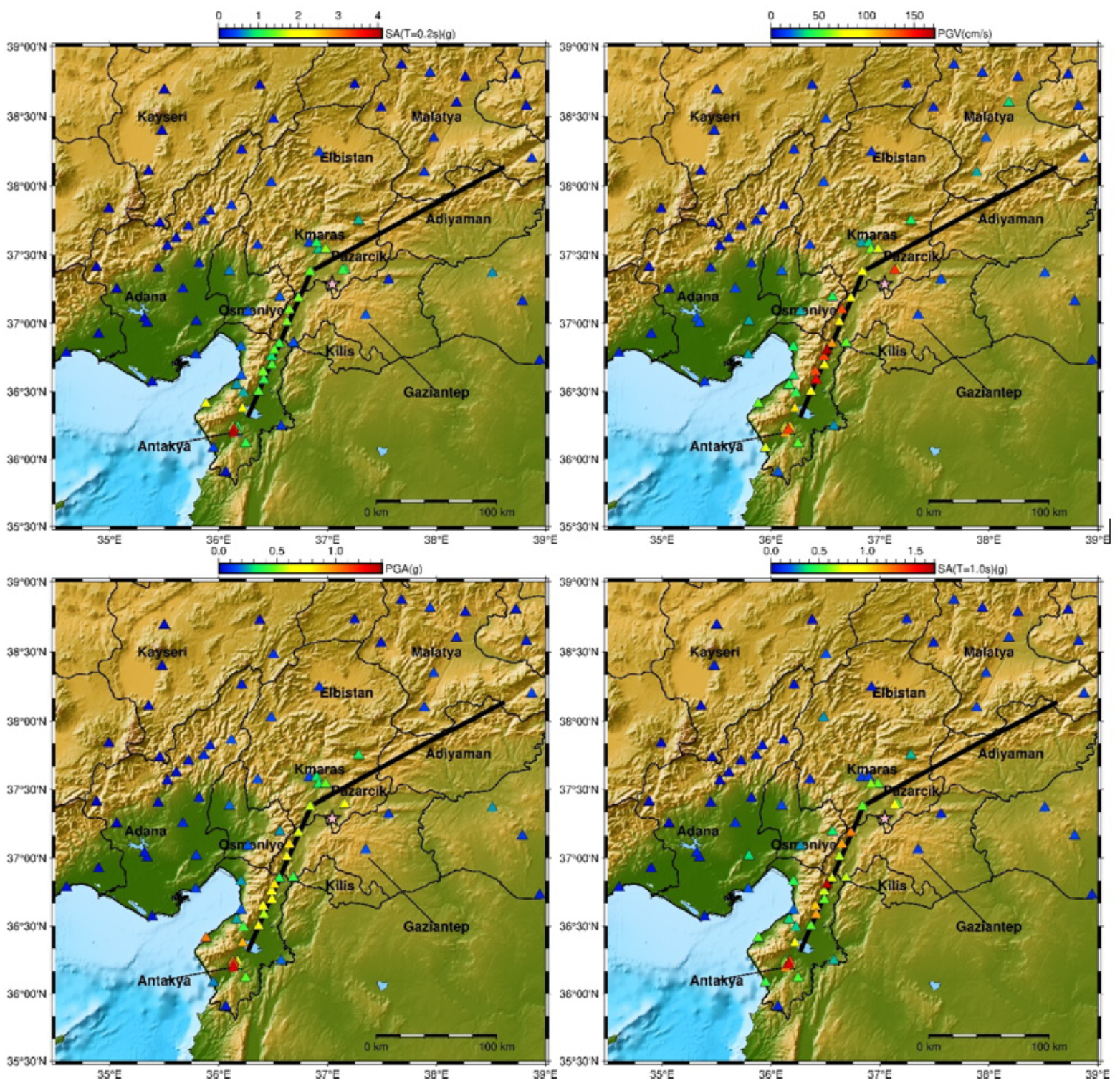
Spatial distributions of peak and spectral ground motion parameters at strong motion stations from the 6 February 2023 Pazarcik earthquake.
The authors of this article are part of a project team (with project code AFAD UDAP-C-21-59) that was funded by AFAD between June 2021 and June 2023 (Askan et al., 2023). The objective of this national project was to assess the seismic resilience of a small-scale industrial city named Turkoglu, located to the south of Kahramanmaras, at the intersection of Amanos and Pazarcik segments of the East Anatolian Fault zone. The objective was to assess the seismic resilience of the region through a detailed study of the nearby fault structures in the field, construction of regional velocity models, ground motion simulations of potential earthquakes, structural vulnerability, and resilience indicators as presented in the flowchart in Figure 3. The Pazarcik earthquake occurred 4 months before the end of the project on the exact fault system, which was modeled in ground motion simulations within the project in 2022. Figure 4 shows the location of Turkoglu, the scenario earthquakes considered, and their fault planes, as well as the considered moment magnitude values (Askan et al., 2022). The scenario events independently considered the Kahramanmaras fault and the Amanos and Pazarcik segments of EAFZ. However, the 2023 Pazarcik earthquake involved a multi-segment rupture on the East Anatolian Fault zone, including the Erkenek, Sakcagoz, and Narlı segments, in addition to the Amanos and Pazarcik segments that were anticipated by the project team, resulting in much longer rupture lengths and releasing much larger energy.
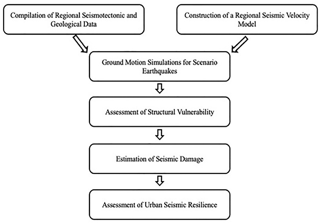
Flowchart of the methodology employed in this study.
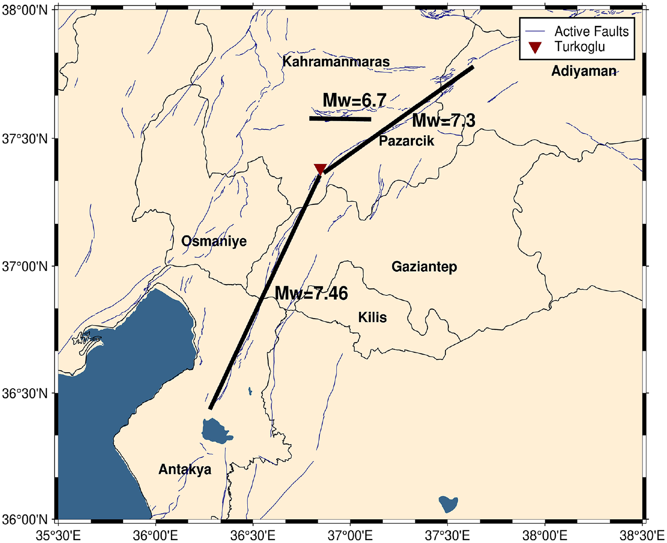
The scenario events considered as part of the AFAD UDAP-C-21-59 project in 2022 (Askan et al., 2022).
The objective of this article is multifold: first, to present our findings before the earthquake (2021–2022) in the region, including regional velocity models, ground motion simulations, street survey-based building classifications, and vulnerability classes; and second, to compare the after-event modeling of damage distributions with the observed damages as well as a resilience evaluation of the region from multiple perspectives. A third objective is to assess the seismic resilience framework used in the project, as there are multiple seismically active areas in Turkiye and the world where similar large events are anticipated. This study constitutes a significant case study in Turkoglu region, which involves critical evaluations of seismic resilience from before and after event data.
Geology and seismotectonics
Turkoglu is located close to the zone where Arabian and Anatolian plates are interlocked. As a result of the collision and interlocking of the plates, the units belonging to the Taurus Orogenic Belt and the Southeastern Anatolian Autochthonous, where significant and large deformations related to the collision are observed north of Kahramanmaras. These units are covered by Miocene, Pliocene, and Quaternary rock units. In Turkoglu, in particular, the units represented by talus and alluviums present extensive outcrops in the plain area to the east of the district center. The sediments located east of Turkoglu center consist entirely of alluviums. Younger alluvial sediments are outcropped in the surrounding stream beds. It can be observed that the thickness of these alluviums varies between 45 and 190 m, and beyond this depth, ophiolite rock units were encountered. In addition, this alluvial fill deeper on the western side is thought to be related to the Amanos segment of the EAFZ and is due to sedimentation.
The study area is located at the intersection of Pazarcik and Amanos segments of the Eastern Anatolian Fault Zone (EAFZ). Historically, Turkoglu has experienced intense tectonic activity. Karasu Valley, which is located at the northwestern end of the study area in terms of geomorphological location and extends from the north of Amik Plain to Kahramanmaras, separates two continental plates and is controlled by the left-lateral strike-slip EAFZ and the Dead Sea Fault Zone (DSFZ). It is considered a releasing bend with a width of 12–35 km and a length of 160 km in a northeast–southwest direction in general. The neotectonic period of structures near the Turkoglu district center is the Pazarcik segment of the EAFZ in the northeast, the Amanos segment of the Anatolian Fault Zone in the south–southwest, and the Sakcagoz and Narli segments of the DSFZ in the east–southeast, respectively (Figure 5). All of these segments were ruptured in the first earthquake (Mw 7.8), with an epicenter located in Pazarcik.
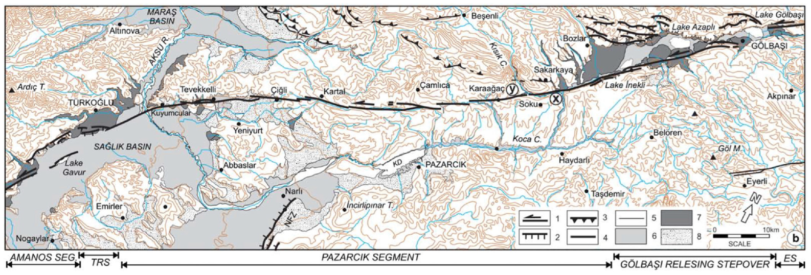
Map of the tectonic structures around Turkoglu: (1) left-lateral strike-slip fault, (2) normal fault, (3) reverse fault or thrust, (4) east Anatolian fault zone, (5) southeastern Anatolia thrust zone; (6) undifferentiated Holocene sediments, (7) undifferentiated Quaternary sediments, and (8) landslides.
Field surveys for regional velocity model and for active fault investigations
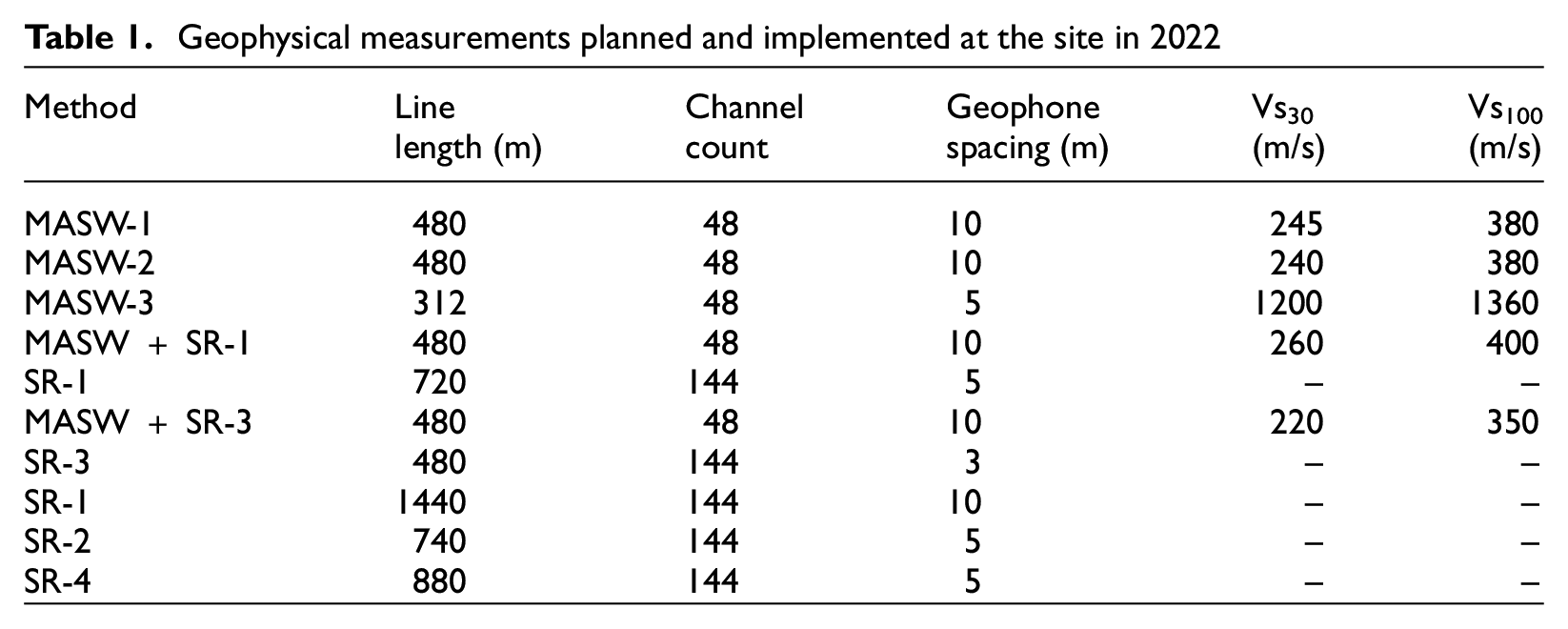
An important component of seismic resilience at any location is the characterization of the local soil structure and the assessment of potential site effects during earthquakes. Multi-channel analysis of surface waves (MASW) method (Park et al., 2001, 2007) is used in this study to obtain the one-dimensional S-wave velocity structure at selected locations in Turkoglu. The MASW method was implemented with 48 geophones at 4.5 Hz. In this study, for active fault investigations, shallow seismic reflection (SR) is used. The free-fall form of weight drop has been frequently used as a seismic source (e.g. Knapp and Steeples, 1986); however, operating such sources in densely populated regions is difficult due to potential damage to asphalt roads and urban infrastructure. A free-fall type seismic source (ESTU-WD500) is used in this study’s high-resolution SR investigations. ESTU-WD500 is employed as an electronically controlled mobile seismic energy with a free-fall 500 kg weight drop. It was determined that two-dimensional imaging of the shallow subsurface structure and SR sections can be obtained up to a depth of 500–1000 m, depending on the geological structure. During the measurement of seismic wave velocity, a velocity profile up to an average of 100 m could be obtained.
SR and MASW surveys are performed at key locations along the fault segments and the settlement of Turkoglu (Figure 6). According to MASW measurements, estimated Vs30 values vary in the range of 220–260 m/s (Figure 6 and Table 1) in central Turkoglu with an assigned site class of D according to NEHRP (2020) classification. When a larger region is considered, the soil layers are found to be much stiffer in the northwest and softer in the east and south, consistent with the topography of the area. The depth of the bedrock obtained in the SR survey reaches approximately 1600 m.
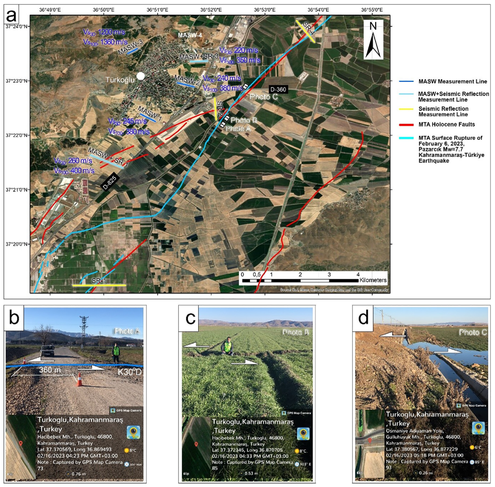
(a) Rupture geometry of the Pazarcık (Kahramanmaras) earthquake along the Turkoglu segment of the EAFZ and seismic measurement (MASW and seismic reflection) lines; location of the photos A, B, C within the study area. (b) Left-lateral displacements on the road, interpreted field photographs of a surface rupture at A, southeast of Turkoglu (Kahramanmaras). (c) Left-lateral displacements on a field at B. (d) Left-lateral displacements on the water channel at C.
Geophysical measurements planned and implemented at the site in 2022
The Holocene fault on the most recent active fault map of Turkiye prepared by the General Directorate of Mineral Research and Exploration (MTA) along the EAFZ coincides approximately with midpoint of the SR-4 line (Figure 6). The surface rupture of the 6 February 2023 Pazarcik (Kahramanmaras) earthquake (Mw 7.8) is, however, observed to be closer to the southeastern end of the SR-4 line (Figures 6 and 7). In a basin where the upper sediment thickness reaches 1600 m, the detection of the surface rupture or fault zone is always challenging. Yet, the reflection results at SR-4 shown in Figure 7 indicate that the uppermost seismic layers are deformed by fault segments, which are evaluated as EAFZ structures at the southeastern side.
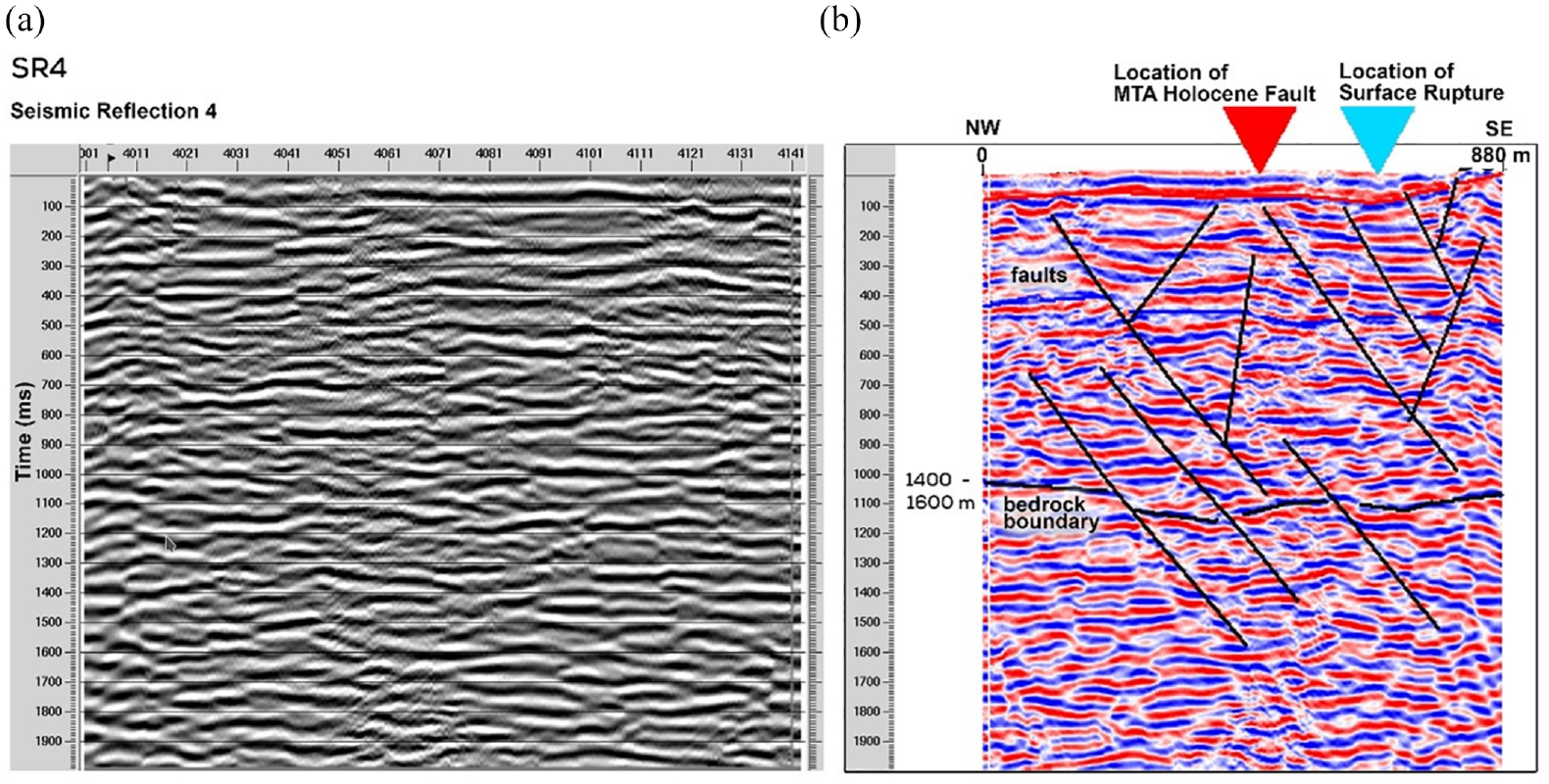
Uninterpreted (a) and interpreted (b) seismic reflection section of SR-4.
Simulated and recorded ground motions in Turkoglu
During the first half of the project (2021–2022), three critical scenario events were considered in the study region (Figure 4). Herein, the scenarios on the Amanos (Mw 7.46) and Pazarcik (Mw 7.3) segments are discussed, as those segments are involved in the first event in February 2023. Stochastic finite fault method as outlined in Motazedian and Atkinson (2005) is employed to simulate these two events with the input parameters shown in Table 2. The most recent open-source code EXSIM12 (Assatourians and Atkinson, 2012) is used to model the ground motions with the stochastic approach based on a dynamic corner frequency (Motazedian and Atkinson, 2005). In this approach, a rectangular fault plane consists of a series of subfaults, each of which is modeled as a stochastic point source. The source, path, and site functions are taken into account for each point source in the frequency domain. Finally, the contributions of subfaults are summed up in the time domain with corresponding kinematic delays to obtain the ground motion at any observation point of interest.
Simulation parameters for the Pazarcik and Amanos scenarios
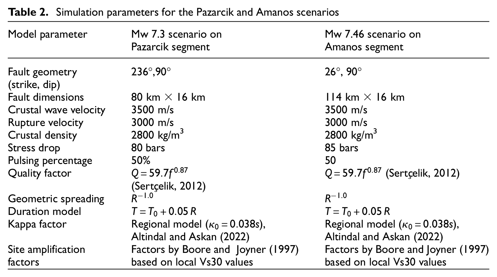
The ground motion simulations are performed at a total of 225 nodes within the Turkoglu town. The location of the simulation nodes in the Turkoglu region is shown in Figure 8. In the stochastic simulation approach, local site amplification factors are applied in the frequency domain as site filters on the Fourier amplitude spectrum. For the local site amplification functions in the frequency domain, we employ the site amplification factors proposed by Boore and Joyner (1997), which use Vs30 value as input. We note that we obtain the local soil information in the form of Vs30 either from the nearest available location of the seismic velocity surveys described earlier, or from the available site characterization data at the seismic station operated by AFAD in Turkoglu (Station 4616).
Location of nodes where ground motion simulations are performed for the scenario events with Mw 7.3 and 7.46.
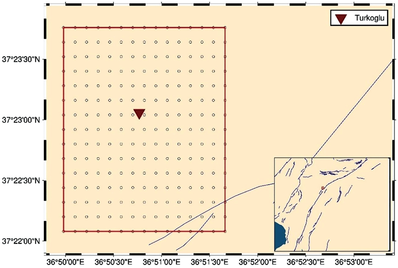
For validation purposes, the simulated ground motions from the two scenario events are compared against two empirical ground motion models, one global and one local model, Boore et al. (2014) and Kale et al. (2015), respectively. Figure 9 shows this comparison in terms of PGA, SA (T = 0.3 s) and SA (T = 1 s). It is observed that the simulated parameters are mostly within ±1 standard deviation of the median values predicted by ground motion models. However, some of the simulated PGA values for the Pazarcik scenario exceed +1 standard deviation of the median values from the empirical models significantly. There is a slight underestimation of the long-period simulated content for both scenarios, which may be attributed to the fact that stochastic ground motion simulations generally estimate the high-frequency content more accurately. It is also worthwhile to mention that the empirical ground motion models are derived with datasets that do not contain a significant amount of data from very large events such as the 6 February 2023, Mw 7.8 event. Finally, it is noted that, despite its larger magnitude, due to longer source-to-site distances, the simulated amplitudes from the Amanos scenario are slightly lower than those from the Pazarcik scenario.
Comparison of simulated ground motions in Turkoglu against empirical ground motion models (Top panel: Pazarcik scenario; Bottom panel: Amanos scenario). The bold lines indicate the median predictions, whereas the dashed lines indicate ±1 standard deviation.
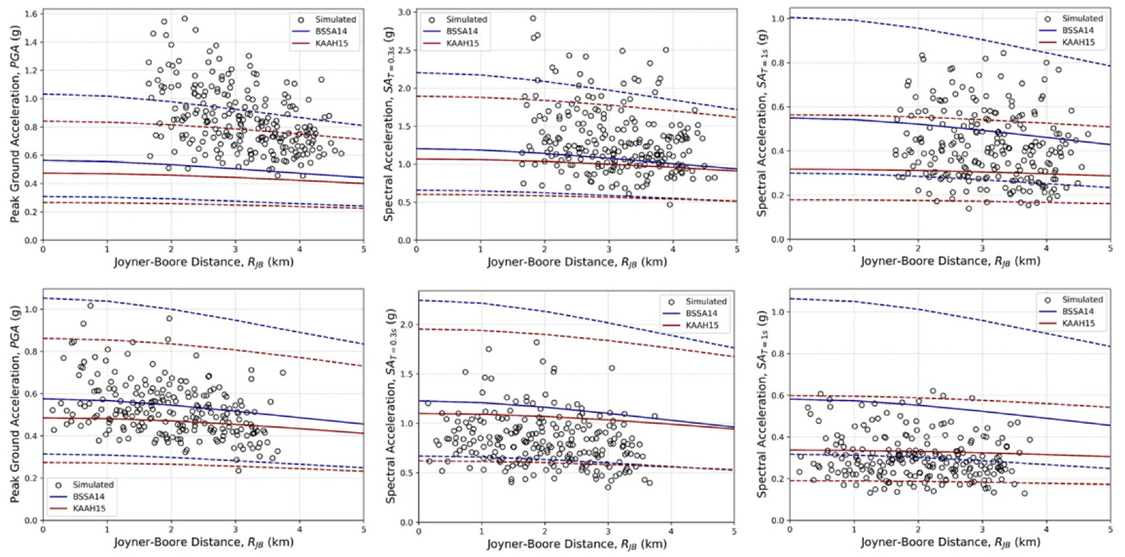
It is noted that the 6 February 2023 Pazarcik earthquake ruptured five segments with Mw 7.8 as shown in Figure 1. The only recorded strong ground motion in the study area, Turkoglu, at Station 4616 is demonstrated in Figure 10. The station is located at a site with Vs30 value of 390 m/s and a rupture distance of 2.3 km. The recorded acceleration time series in all three directions consist of multiple wave packets peculiar to this earthquake due to the rupture of multiple fault segments and the very long rupture length. It is observed that the maximum ground acceleration value measured in Turkoglu is approximately 0.6 g. The geometric mean of the horizontal response spectra with 5% damping is observed to be above the design spectrum with a return period of 475 years, while the north–south (NS) component almost reaches the design spectrum with a return period of 2475 years in the short-period range.
(a) Recorded accelerations at the Turkoglu Station 4616. (b) Comparison of the response spectral accelerations with the design spectra in TBEC (2018). (c) Location of Station 4616.
The scenarios did not fully predict the real event. However, the recorded motion at Station 4616 is compared with the suite of simulations for the previously performed scenario events in Figure 11. Here, it is observed that the amplitudes of the recorded motions are close to the maximum simulated amplitudes, despite the differences in magnitudes and source-to-site distances. A structured and validated database for simulated ground motions for Turkiye including this particular region can be found in Altindal and Askan (2023).
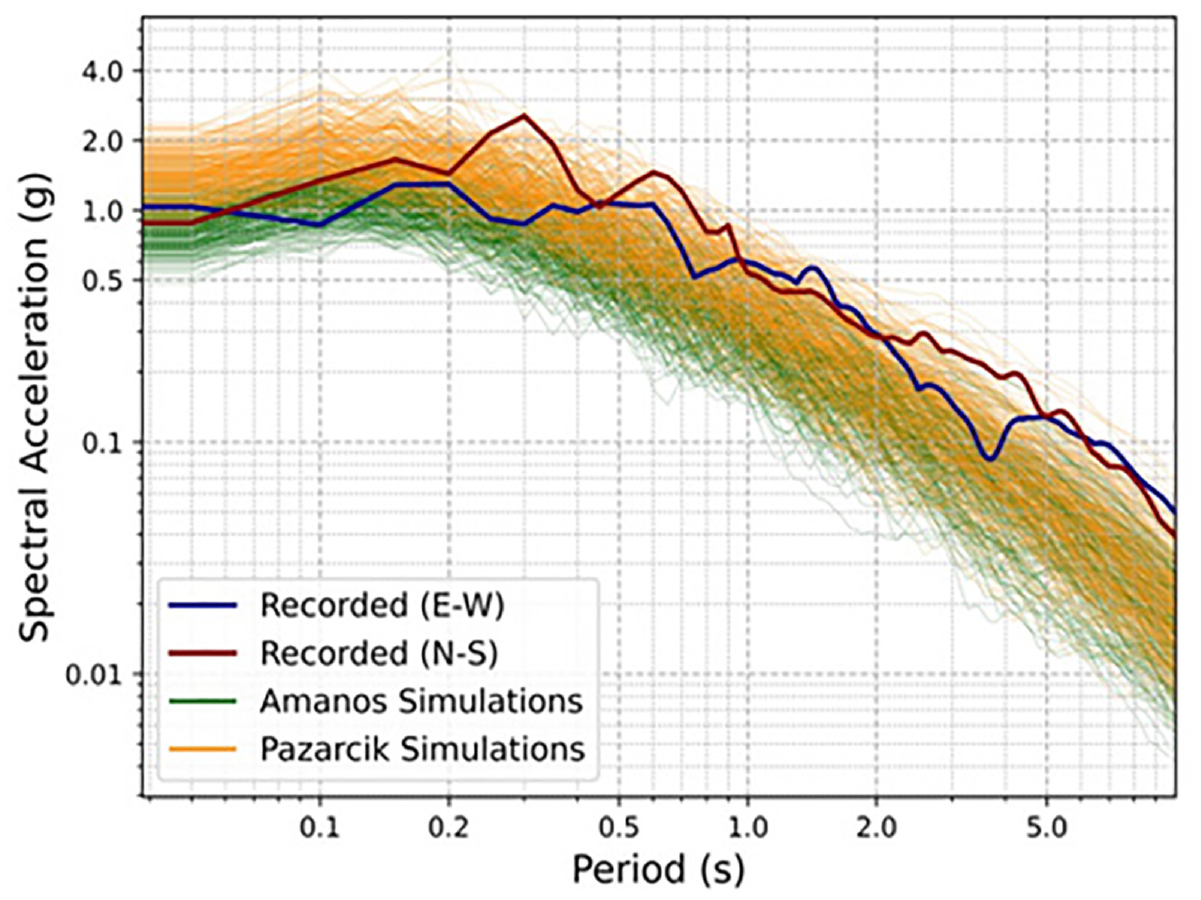
Comparison of the recorded ground motion at Turkoglu Station 4616, with the suite of simulated ground motions.
The simulated ground motions presented here are employed in the derivation of the fragility curves which are presented next.
Structural characteristics, GIS application for building data, and fragility models
Turkoglu district is in the south of Kahramanmaras province with a population of nearly 80,000 people as of 2022 according to TSI (Turkish Statistical Institute) data. Although there are 44 neighborhoods in Turkoglu, only 6 of the central neighborhoods with denser population and settlement have been considered within the context of this study. The metadata related to the building stock characteristics in Turkoglu district has been obtained from building census information by TSI and also from the Turkoglu Municipality, Department of Construction Works before field studies. However, the obtained data contained only the buildings with proper construction records. The total number of buildings considered in six neighborhoods is 12,932. Turkoglu town unfortunately contains some non-engineered structures as well, which were constructed using traditional techniques ignoring the seismic design principles. TSI data also reveal that more than half of the registered buildings had been constructed before 2000. This indicates that a considerable percentage of the buildings in Turkoglu are more than 20 years old and they had been constructed using the old-fashioned 1975 Turkish Seismic Code.
TSI and municipality data show that more than 90% of the buildings are being used for residential purposes and about 92% of the buildings have either one or two stories. Most of these low-rise buildings can be classified as unreinforced masonry (URM) construction. According to the available data, the construction of mid-rise buildings (4–8 stories) has an increasing trend after the year 2010 and most of them are reinforced concrete (RC) frame or RC dual (i.e. frame and shear wall) buildings.
In the next phase of the study, field studies were carried out to obtain the major structural parameters of the buildings in the considered neighborhoods in June 2022 (8 months before the Kahramanmaras earthquake sequence). Since the number of buildings exceeds 10,000 in the considered neighborhoods, a practical street survey approach is employed for rapid condition assessment of the existing buildings, which takes approximately 5 min per structure (Figure 12, left panel). This survey includes taking several photos of the buildings from different facades and collecting six general parameters (building ID, coordinates, constructing year, number of stories, occupancy type, and construction material type). Depending on the structural system type, several specific parameters are also collected. The specific parameters are presence of shear walls, concrete quality, irregularity in plan, irregularity in elevation, presence of deficiencies like soft/weak story, heavy overhang, and/or short column for RC structures. For masonry structures, the specific parameters are masonry material type, construction quality including material and workmanship, type of floor slab, irregularity in plan, irregularity in elevation, location, and number of openings in load-bearing masonry walls. The data collection was performed using cellular phones and tablet PCs where the collected data were immediately sent to an online server through a Global Positioning System (GPS)-based application in the ARCGIS platform (Figure 12, right panel). The collected data were also checked and verified in an office environment by comparing the photos with the collected parameters from each building. Overall, valuable building data were compiled regarding the building stock in Turkoglu neighborhoods just a few months before the earthquake sequence. A total of 3700 buildings, as marked in Figure 12, were evaluated in the region.
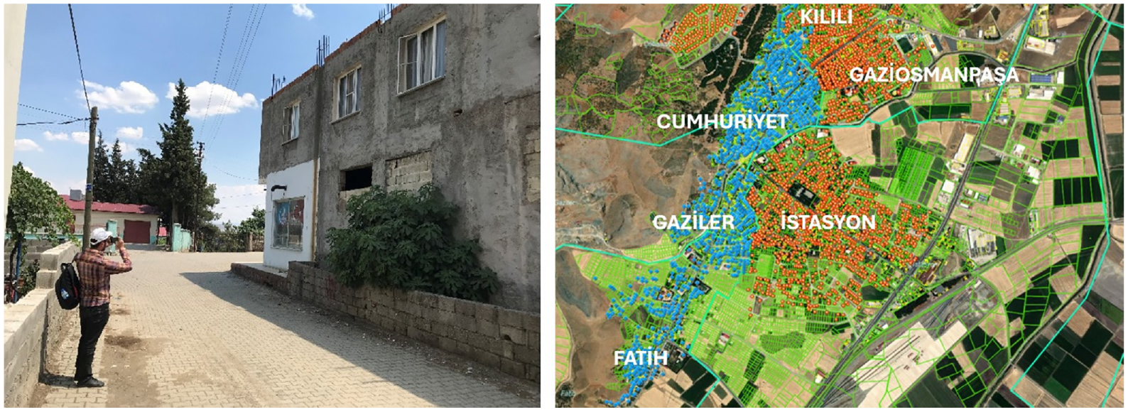
Field studies in Turkoglu (left panel); map of the investigated buildings during the street survey (right panel).
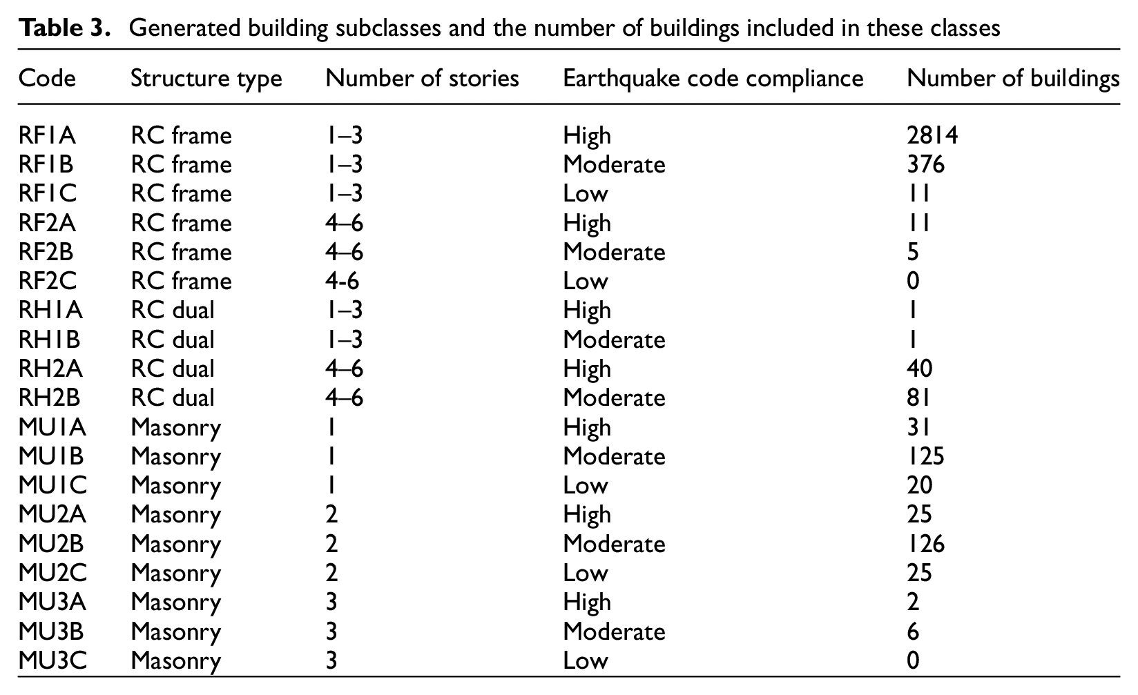
The building categorization scheme that was considered for previous regional earthquake risk assessment studies in Duzce (Ugurhan et al., 2011), Erzincan (Karimzadeh et al., 2018), and Gaziantep (Arslan Kelam et al., 2022) provincial centers was also adapted in this study. Table 3 displays the 19 distinct building subclasses that have been identified within the framework of this categorization for the building stock in the Turkoglu district. The major classification parameters are construction type, number of buildings, and level of compliance with seismic codes. A four-letter abbreviation has been used for the building subclasses, in which the first two letters stand for the construction type (RF = RC frame, RH = RC dual, MU = URM), the third one for number of stories (for RF and RH subclasses 1 = low-rise with 1–3 stories, 2 = mid-rise with 4–6 stories and for MU subclasses 1,2,3 = actual number of stories), and the last one for the level of code compliance (A = high level, B = moderate level, C = low level). Considering the definitions of level of code compliance, buildings with good apparent material quality and no significant structural deficiencies (such as soft stories or irregularities in the horizontal and vertical directions) that are considered to be in such buildings are expected to exhibit an adequate margin of structural safety. On the contrary, buildings that correspond to “low level” of code compliance appear to have poor construction quality, major structural deficiencies, so they are expected to show poor performance during a major earthquake. There are certain buildings that partially comply with earthquake design criteria, classified as “moderate level” in terms of earthquake code compliance. A scoring method that takes into account the major structural parameters acquired in the field (mentioned in the previous paragraph) has been developed in order to link each RC and masonry building examined in the field with the appropriate level of code compliance (i.e. A, B or C). The final column in Table 3 displays the number of buildings in Turkoglu district that match the corresponding building subclasses after reviewing all the collected building data from the field study.
Generated building subclasses and the number of buildings included in these classes
The next phase includes the generation of representative single degree of freedom (SDOF) structural models for each building subclass. The present work employs a multiparameter hysteretic model (Ibarra et al., 2005) to idealize the global behavior of the preexisting RC and masonry construction types. Several researchers have assessed this model using actual data (Ibarra and Krawinkler, 2005; Lignos and Krawinkler, 2011, 2012). Furthermore, it has been embedded into the open-source structural analysis platform, OpenSees (McKenna, 2011). The input parameters of this model can be listed as elastic stiffness, yield force capacity, ultimate force capacity, ductility ratio, residual force capacity, maximum displacement (at ultimate and residual capacities), and degradation parameter based on energy dissipation capacity of hysteretic behavior. These model parameters had already been determined in past research and applied to all RC and masonry building subclasses (Arslan Kelam et al., 2022; Karimzadeh et al., 2018). Among all the model parameters, period (initial stiffness), strength ratio (yield force capacity/weight), and ductility ratio were regarded as random variables in these studies. The mean and standard deviations of these parameters were then determined for each building subclass. The values of the remaining model parameters were considered as constant, depending on the building subclass under consideration.
A sampling strategy should be used to obtain structural simulations while creating idealized models for each class of buildings. This study uses a segmentation-based sampling technique called as the Latin hypercube sample (LHS) method (McKay et al., 1979). Over the past 20 years, the LHS approach has been widely employed in structural earthquake engineering research, because it provides a cheaper computing cost compared with the Monte Carlo method. This is due to the fact that the LHS can produce estimated results for the desired accuracy level with a limited number of samplings (Erberik, 2008; Erberik and Elnashai, 2004). For this reason, 20 samples for each random variable have been generated in this study by using the LHS sampling strategy. The SDOF structural models are then developed by using 20 sets of input parameters, each of which represents 1 of 19 different building subclasses. For details regarding the input structural parameters, one can refer to Table 3 in Karimzadeh et al. (2018). A total of 152,000 nonlinear time history analyses (NLTHAs) were applied using 400 synthetic ground motion data that have been simulated by considering the scenario earthquakes. The II-DAP software (Elkady and Lignos, 2019), which incorporates the previously described Ibarra–Krawinkler hysteretic model, has been used to execute the NLTHAs.
Peak ground acceleration (PGA) is chosen as the intensity parameter, whereas maximum displacement is chosen as the response parameter in the SDOF simulations. The PGA values are obtained from the scenario simulations presented previously. Three limit states (LS) were attained as thoroughly explained in the project final report (Askan et al., 2023) based on particular definitions and presumptions. Detailed information about the limit state definitions has been provided in Karimzadeh et al. (2018). The LS values for all building types have been presented in Table 4 of the same reference. The fragility curves are obtained by calculating the probabilities of exceeding each limit state for the given vertical distribution of displacement statistics obtained from the NLTHAs at each intensity level. The scatter plots in Figure 13 represent these probabilities of exceedance at each PGA level. Finally, continuous fragility curves are obtained by fitting lognormal cumulative distribution functions to the scatter points. The fragility curve sets for selected building subclasses are presented in Figure 13. It is observed that the nature of fragility information shows significant differences with respect to the considered classification parameters. For instance, the LS of masonry subclasses are close to each other, indicating a narrow margin between the onset of damage and collapse. This can be attributed to the limited ductility capacity of this construction type. The same trend is not observed in RC frame and dual buildings since they have higher inelastic displacement capacity. Moreover, as the number of stories increase and the level of code compliance becomes lower, the buildings become more fragile as expected.
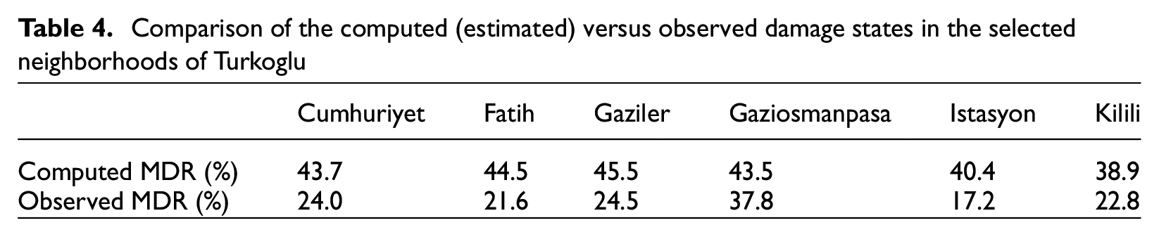
Comparison of the computed (estimated) versus observed damage states in the selected neighborhoods of Turkoglu
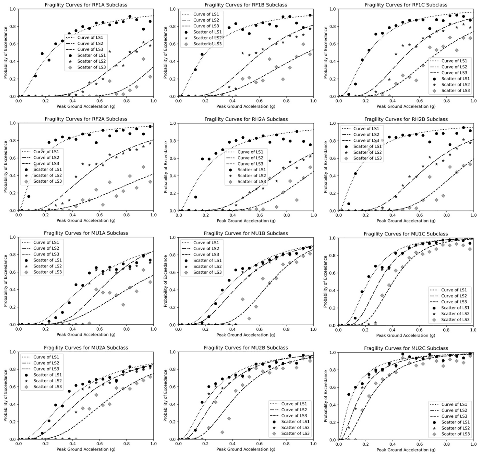
Generated fragility curves for different building subclasses.
Comparison of observed and estimated building damages
Considering the 6 February 2023 earthquakes, the first event seems to have a significant impact on the buildings in Turkoglu district, although some of the damaged buildings have been reported to have collapsed during the second event.
Following the earthquakes, researchers from the project team made multiple trips to Turkoglu district in an attempt to gather comprehensive data regarding the damage caused by these earthquakes. The researchers used the building inventory data in the GIS environment that had been collected 8 months before the 2023 earthquakes and reported the damage experienced by the buildings in six neighborhoods within the collected database (Please see Supplementary Material for the building database). The field data were also supported by the address-based damage assessment reports prepared by the Disaster Coordination Information System by the Ministry of Environment, Urbanization, and Climate Change. Finally, all damage data were combined in the GIS environment for a more complete building damage database of the Turkoglu district. As presented in Figure 14, damage distribution in Turkoglu is mapped with a color code representing the status of each surveyed building. As a result, the damage conditions of the buildings under examination can also be seen on the map.
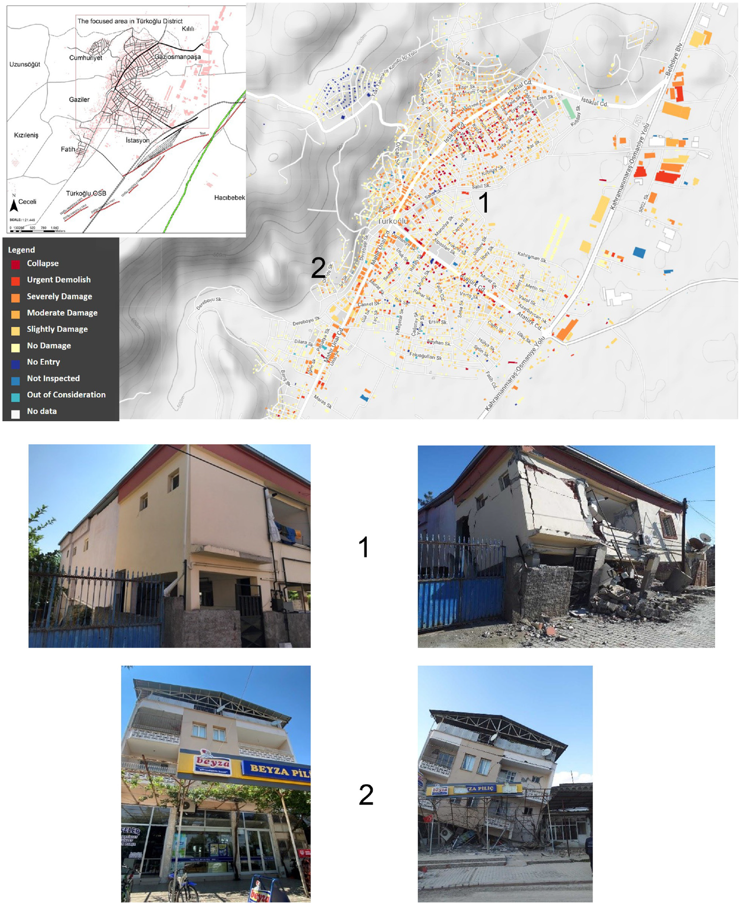
Damage distribution map (top panel), before and after-event pictures of existing buildings (mid-bottom panels).
Next, the actual damage distribution is compared with the estimated damages by using the fragility curve information of building subclasses. For this task, the approach described in Askan and Yucemen (2010) has been employed, as shown in Figure 15. According to this approach, it is stated that damage probability matrices (DPM) created for any region and structure class can be obtained directly as empirical and discrete probabilities from field observations, or it can be calculated as discrete damage probabilities from continuous fragility functions. The final report of the Turkoglu project (Askan et al., 2023) provides a detailed description of mean damage ratios (MDR). In this study, the generated fragility curves, which show the estimated damage based on the recorded PGA value used in each population center, are employed to calculate the damage probabilities. The MDR values for the various building subclasses were merged in accordance with the distribution percentages of those distinct building types in the region. The obtained values were finally compared with the actual MDR computed from the damage distributions observed in the field (Table 4). The observed damages are higher at sites with softer soil conditions and closer distances from the fault segment. The results in Table 4 reveal that the computed MDR values are higher than the observed MDR values in all neighborhoods, but a very close match is obtained in Gaziosmanpaşa neighborhood. There are three major reasons for the difference between the observed and the estimated damage ratios. First, since there is only one recording station in central Turkoglu, the spatial variations of the wave field are not fully considered. Second, the compulsory use of simple and idealized structural models due to the vast number of dynamic analyses eventually requires some conservatism compared with more detailed and reliable modeling strategies. Third, due to the hundreds of thousands of buildings to be inspected after the earthquake, the Ministry of Environment, Urbanization, and Climate Change deployed thousands of technical persons with different levels of experience and skills in the earthquake affected area. Therefore, the damage assessments carried out by this non-homogeneous and non-standard group of technical people contain many discrepancies and the collected data are considered to contain substantial uncertainties.
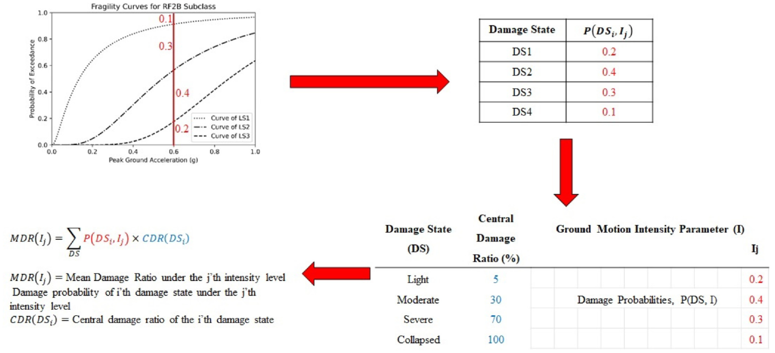
Flowchart for mean damage ratio calculations for a single building subclass, as implemented in Askan and Yücemen (2010).
Observations on liquefaction and lateral spreading in the region
Following the 6 February earthquake sequence, the secondary effects of the earthquake (i.e. liquefaction, lateral spreading) were examined in Turkoglu to find out whether the soil caused any damage. Field observations revealed liquefaction manifestation in the form of lenses along the surface, especially in free field areas without settlement outside the district center (Figure 16, left panel). However, in areas of young alluvial sediments in the district center, no sign manifestations of liquefaction outcropped at the surface. Thus, at these locations, apparent deformation effects on the structures related to these effects have not been observed (bearing capacity failure, lateral deformation, etc.), which were obvious in other districts in the earthquake-prone regions (i.e. Golbası, Iskenderun). Only deformations due to lateral spreading in the retaining structures in the canal along the stream passing through the Turkoglu center and soil softening on the fill materials were encountered in these settled areas (Figure 16, right panel).
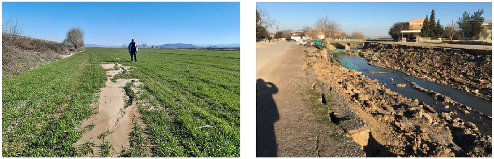
Liquefaction-induced manifestations along the free field area outside Turkoglu district center (left panel). Ground deformations due to lateral spreading in the retaining structures in the canal along the stream passing through Turkoglu center (right panel).
When a few of the compiled boring logs before the earthquakes in the region are examined, it is inferred that there are non-liquefiable clayey soil layers above the relatively liquefiable soil, varying in different thicknesses from the surface to a certain depth (from 3 to 15 m), and this might create a cap effect and prevent the signs of liquefaction (Ishihara, 1985), or it may only appear as soil softening on the surface mentioned previously. This situation also explains why liquefaction in the free field environment, instead of sand boils, is seen as lenses emerging from ground cracks on the surface (Figure 16, left panel). In areas with young alluvial sediments in the district center, local site conditions may significantly affect the amplitude and frequency of ground motion during earthquakes, and earthquake damage can frequently be observed to be much greater on these unconsolidated sediments, which would cause increased structural damage depending on the soft soil conditions. However, without detailed studies and related verification analyses after the earthquake regarding the local site effects, particularly liquefaction, it cannot be stated whether the earthquake-related damages during the 6 February sequence were caused or increased by liquefaction. Hence, more comprehensive and in-depth research on this subject could significantly contribute to the earthquake resilience in the region.
Urban disaster resilience before and after the 6 February Kahramanmaras earthquakes
Turkoglu town was investigated regarding various parameters of earthquake disaster resilience at the neighborhood and district levels comprehensively. For this assessment, some of the specific items have been selected from “A Checklist of Ten Essentials for Making Cities Resilient” identified by UNDRR (2010, 2017). The concept of resilience is considered as the combination of physical (safety of building stock, education and health services, critical infrastructure), institutional (organizational preparedness for recovery and reconstruction), social (preparedness of civil society), and economic (budget management for risk reduction investments) aspects in any disaster-prone community in the related literature (UNDRR, 2017). Some studies in this respect focus on creating a framework for assessing community resilience including not only physical aspects but also social, economic, and environmental (Cimellaro et al., 2016). The main idea behind most studies on the impacts of resilience is that a resilient community can take necessary measures before any disaster hits, so that when the destructive event happens, the community may recover quickly and rebuild its physical, institutional, and economic settings into better situations than their previous versions. In other words, “community seismic resilience is defined as the ability of social units (e.g. organizations, communities) to mitigate hazards, contain the effects of disasters when they occur, and carry out recovery activities in ways that minimize social disruption and mitigate the effects of future earthquakes” as Bruneau et al. (2003) highlighted.
Based on the spatial data collected about Turkoglu area before the 2023 earthquakes, damage potentials in neighborhoods, together with the urban land-use and planning decision analysis, and the level of urban seismic resilience were investigated. Although it is possible to perform resilience indicators using diverse parameters (Tsionis, 2014) for urban regions for comparison purposes, microlevel local spatial analysis helps us to understand actual seismic resilience of a specific community. Thus, within the scope of this article, a microlevel spatial analysis is conducted focusing on three major areas of intervention, such as building stock risks (damage estimations), location/accessibility of emergency support facilities such as hospitals, educational buildings, governorships, provincial AFAD buildings, and public buildings; and finally the distribution of incompatible uses including factories and flammable/explosive facilities that may trigger secondary disasters such as fires and explosions.
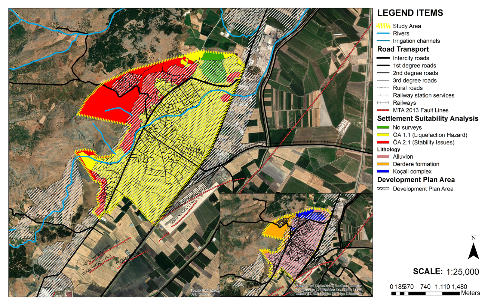
Before the analysis of such items, the town’s development history is reviewed since the history of urban land-use planning decisions might show us the mistakes on locational decisions for vulnerable land-uses. Based on the review of town planning and development history as well as population growth, Turkoglu district was selected nationally to be a logistic center toward the southern part of Kahramanmaras province. The objective was to help Turkoglu develop by several investments such as industrial zone developments in 2008 and 2021 and a major train station, including storages in 2017 to serve the East Anatolia Region (Figure 17). The mentioned developmental decisions, in turn, led to an increase in population and settlement growth on agricultural land closer to the active fault zones and alluvial deposits (Figure 18). Some of the current land-uses indeed coincide with the specific land types like “OA1.1” (meaning: Precautionary Areas in terms of Liquefaction Hazard) and “OA2.1” (meaning: Areas with Stability Issues which may Require Precautions), which necessitated proper application of seismic codes. On the contrary, located in a critical logistic region, Turkoğlu city center has an advantageous position during and after any disastrous earthquake like the 2023 earthquakes fostering its recovery due to transfer of emergency aids.
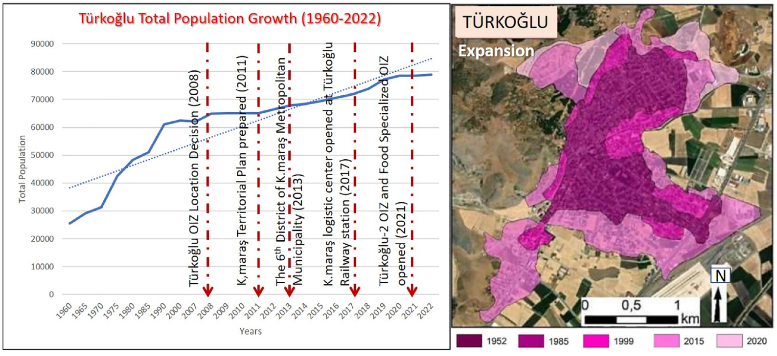
Turkoglu population growth in relation to locational decisions and investments.
Turkoglu development plan and settlement suitability analysis comparison.
Moreover, the main distribution lines of the infrastructure systems such as electricity and natural gas are located in the field, either very close to the fault segments or intersecting them (Figure 19). When there are no special features such as flexible pipe systems and automatic shutdown systems required for areas with high seismic hazard, secondary disasters are possible such as fire, heating problems, and long power cuts. Before the earthquake, the resilience analysis in the region indicated such high-risk areas; however, after the earthquake such instances were fortunately not observed.
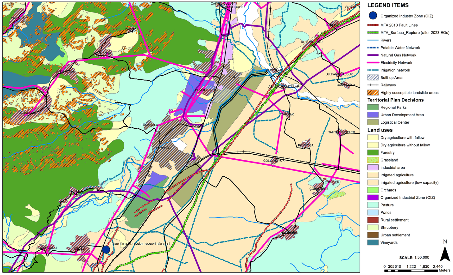
Turkoglu infrastructure, territorial plan decisions, land-uses, and 2023 surface rupture.
Next, we evaluated building stock risks, location/accessibility of emergency support facilities such as hospitals, educational buildings, governorships, provincial AFAD buildings and public buildings; and finally the distribution of incompatible uses including factories, flammable/explosive facilities that may trigger secondary disasters such as fires and explosions. Figure 20 demonstrates the spatial distribution of the estimated and observed MDR in neighborhoods of Turkoglu with the corresponding population densities. Based on the populations of 2018, the crowded neighborhoods are found to be generally closer to the intercity road and fault segments and to have higher damage potential before the earthquake. The population of Gaziler neighborhood, which is one of the locations where the estimated MDR is relatively higher, is 2181, while it is 3185 and 3013 in Fatih and Cumhuriyet neighborhoods, respectively.
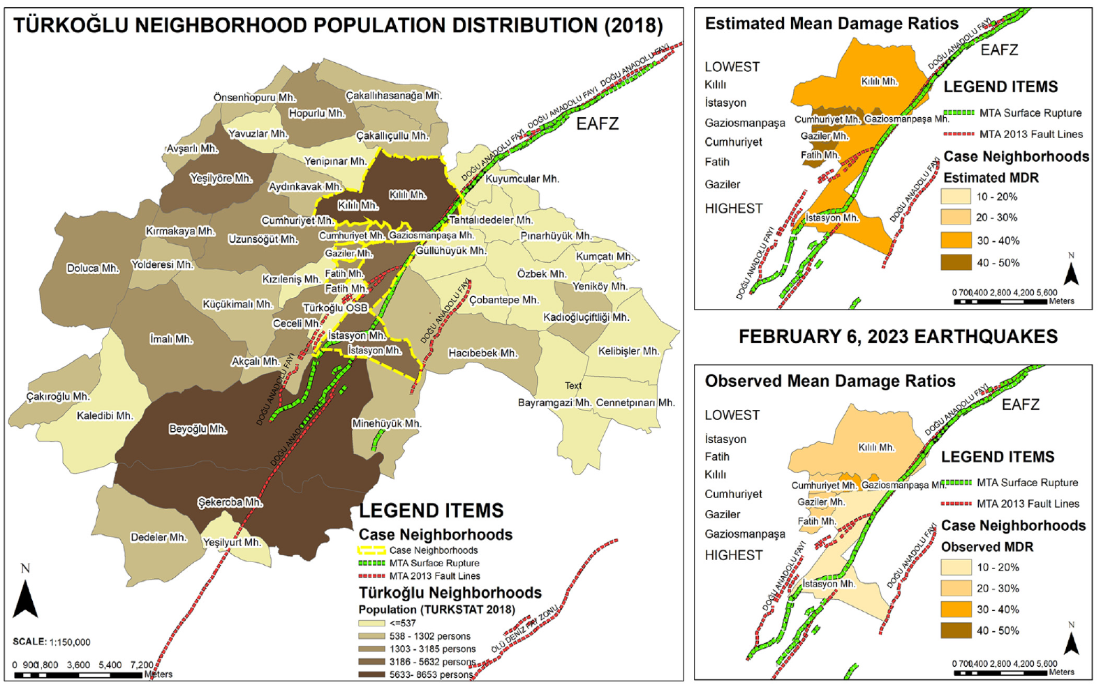
Spatial distribution of neighborhood populations in Turkoglu district (2018) and computed versus observed mean damage ratios.
The performance and location/accessibility of emergency support facilities such as hospitals, educational buildings, governorships, provincial AFAD buildings, and public buildings are always critical in terms of seismic resilience. At the pre-earthquake evaluation, a total of 147 buildings consisting of public, education, and health buildings in six neighborhoods in Turkoglu are considered critical. These critical buildings should stand during emergencies so that emergency officers can decide to change their current functions to temporary shelters when necessary. For this reason, critical buildings should have high seismic performance. However, during the 6 February 2023 earthquakes, there were schools, hospitals and health centers, public institutions, and facilities which were damaged in Turkoglu.
The distribution of incompatible uses, such as factories and flammable/explosive facilities, were also investigated since these facilities have the potential to trigger secondary disasters such as fires and explosions. In Turkoglu, both LPG-fuel stations and industrial facilities can cause explosions and fire incidents due to their proximity and flammable explosive materials as shown in Figure 21. The residential, commercial, and open areas in Turkoglu are in close vicinity of dangerous uses and thus are found to be critical in large events. Fortunately, such explosions did not occur here after the earthquake. In the future, in order to avoid such risks, it is important to plan such incompatible uses away from densely populated areas.

Fault impact zones, LPG-fuel oil stations, and industrial plant impact zones comparing surface rupture and collapsed buildings after the February 2023 earthquakes.
Hence, after the 6 February earthquakes, damage was observed not only in the residential units in Turkoglu, but also in non-residential buildings such as public facilities, schools, and health facilities. Fortunately, major secondary disasters are not observed in this urban area. It is known that there was a minor explosion in the natural gas pipeline near the railway station; however, it did not cause extensive damage. During the field trip after the earthquakes, it was observed that there was a lot of damage and isolated fires in the industrial facilities located in the northeast area of the train station. However, the effects were relatively limited.
Overall, the losses suffered by Turkoglu are relatively lower than those of the central districts of Kahramanmaras. For this reason, Turkoglu has started its recovery relatively sooner. Primarily due to its accessible location via the nearby transportation lines, Turkoglu could benefit from the aid easily and even help Kahramanmaras city center and its immediate surroundings in the aftermath of the earthquakes. Within the first 2 weeks, the area still suffered, even though Turkoglu’s recovery position was comparatively better than that of the nearby towns. This is mostly due to the fact that, according to reconnaissance studies, emergency actions, such as medical response, had shortcomings (Senol Balaban et al., 2024).
Post loss amplification and insurance rates
The impact of big disasters can be amplified due to several issues that are encountered after the initial event, which is known as the post loss amplification (PLA). This amplification can be due to increased construction cost because of increased demand exceeding the available supply in terms of construction materials or labor, increasing transportation costs to access the affected area, increased costs due to reconstruction needs with better engineering and workmanship, and additional expenses due to demolition, debris removal, and cleaning the site before reconstruction (Hoyos and Silva, 2024). Since the 2023 Turkiye earthquake sequence is a catastrophic disaster that affected a wide region of 11 populated cities, PLA-based losses become an important part of the total earthquake loss. Hoyos and Silva (2024) developed an empirical model in terms of gross domestic product (GDP) and return period to estimate the PLA. For the 2023 earthquakes, the official reports state that the total burden of the 2023 disaster on the Turkish economy is US$103.6 billion, which may amount to 9% of GDP in 2023 (Turkey Presidency of Strategy and Budget, 2023). According to Hoyos and Silva, this corresponds to PLA levels approximately between 30% and 40%. However, as it has been mentioned earlier, PLA may not be as critical for Turkoglu as it has been for the city centers of Kahramanmaras, Hatay, Adiyaman, and Malatya, due to the easy accessibility of the city, small scale of the populated area, relatively limited number of heavily damaged and collapsed buildings, and smaller number of blockages due to collapses.
Another important aspect of seismic resilience is the percentage of earthquake-insured properties in the considered region. As known, after the devastating 1999 earthquakes in Turkiye, Turkish Natural Catastrophe Insurance Pool (TCIP) was founded to provide Compulsory Earthquake Insurance (CEI) for householders all over the country. Before the 6 February 2023 earthquakes, the penetration rate (i.e. percentage of CEI policyholders) in Kahramanmaras province was 54% (Sarıaslan, 2023). For comparison, the average penetration rate in 10 earthquake affected provinces is given as 49% in the same reference. Furthermore, as of March 2023, the total penetration rate in Turkiye is around 58% (Meral, 2023). This means the penetration rate in Maras is above the average of earthquake affected provinces and below the national average. It should also be mentioned that in Turkoglu, this value can be lower due to the fact that a considerable percentage of the local building stock is composed of old, rural, and non-engineered buildings, which are out of the scope of the CEI. Hence it can be assumed that approximately 30%–40% of the buildings in Turkoglu had been insured by the TCIP. Although this rate does not seem to be sufficient for a town with perceived level of high seismic hazard and risk, it should be pointed out that the socioeconomic conditions in Turkoglu also play a critical role in the policyholdership rate. With the construction of new buildings in Turkoglu, it is probable that the penetration rate will increase rapidly due to the raised public awareness after the recent earthquake, following the examples of high penetration rates in other provinces like Bolu (98%), Yalova (94%), Duzce (82%), and Kocaeli (73%), which had experienced the 1999 earthquakes (TCIP, 2021).
Conclusion
This article presents the main findings from a national project funded by the AFAD between June 2021 and June 2023. The proposed framework of the study included the assessment of active faults in the region, construction of regional velocity models, ground motion simulations of potential earthquakes, structural vulnerability, and study of seismic resilience indicators. The pilot area of this national project was a small-scale industrial town named Turkoglu, located south of Kahramanmaras, at the intersection of the Amanos and Pazarcik segments of the East Anatolian Fault zone. The city closely experienced the 6 February 2023 Kahramanmaras earthquake sequences, which occurred 4 months before the end of the project on the exact fault system. This study constitutes a significant case study in the Turkoglu region, which involves critical evaluations of seismic resilience using before and after-event data.
The following are the main findings of this study:
Geophysical field surveys yielded information on the regional velocity structure in Turkoglu. It is observed that the sediments are relatively stiffer in the northwest part and loose alluvial sediments in the eastern and southern parts of the research area. In addition, the SR study conducted prior to the February 2023 sequence had identified the fault segments that ruptured during these events.
The ground motion simulations for the selected scenario events in the area before the February earthquakes did not consider the entire fault rupture observed during the February 2023 earthquake. However, even though Amanos and Pazarcik segments were assumed to rupture independently in the scenarios with shorter rupture lengths, the simulated ground motion amplitudes still exceeded the mean prediction of empirical models. In addition, the simulated ground motions are observed to envelope the observed recorded motion in Turkoglu closely, with some simulated data exceeding the recorded levels. Thus, ground motion simulations of potential seismic events can be significant tools to assess anticipated ground motion levels in areas of high hazard with long return periods.
The MDR estimated based on detailed field surveys of buildings are in a similar order of magnitude with the observed MDR after the 6 February 2023 earthquake sequence. There are certain discrepancies mainly due to modeling limitations and limited data availability, which could be improved in future similar studies.
Observation of seismic resilience indicators in the region indicated that Turkoglu had potential for secondary disasters after these large earthquakes. Fortunately, such secondary events were very minor and not extensive.
Overall, the losses suffered by Turkoglu are relatively lower than those of the central districts of Kahramanmaras. For this reason, Turkoglu has started its recovery relatively sooner. Primarily due to its accessible location via the nearby transportation lines, Turkoglu could benefit from the aid easily and even help the center of Kahramanmaras and its immediate surroundings in the aftermath of the earthquakes. Even if the recovery situation was relatively better in Turkoglu than the surrounding towns, the region still suffered within the first 2 weeks. This is mostly because the emergency activities including medical response and community impact had shortcomings based on reconnaissance studies (Senol Balaban et al., 2024).
The multidisciplinary approach employed in this study revealed that earthquake resilience is an integrated concept that requires input involving seismotectonics, local soil conditions, simulated ground motions, structural damage models, as well as urban planning.
The 6 February 2023 earthquake sequence occurred by the rupture of multiple long fault segments on the East Anatolian Fault Zone and generated very intense ground motions. Coupled with the high structural vulnerability of the relatively old building stock in the area, the events caused around 50,000 casualties. The national project presented in this article had started 2 years before the 2023 earthquakes. However, there was not sufficient time to implement the findings of the project in practice to mitigate the well-identified risks. Yet, the entire experience shows how important it is to study seismic resilience in regions of seismic gaps. Naturally, this region is not the only seismic gap in Turkiye or in the world. Similar multidisciplinary studies should be performed in regions with high seismic hazard and risk along with historical earthquakes with long return periods. It is critical to study in advance the potential effects of large events such as the February 2023 sequence.
Supplemental Material
sj-xlsx-1-eqs-10.1177_87552930241274715 – Supplemental material for Assessment of urban seismic resilience of a town in Eastern Turkiye: Turkoglu, Kahramanmaras before and after 6 February 2023 M 7.8 Kahramanmaras earthquake
Supplemental material, sj-xlsx-1-eqs-10.1177_87552930241274715 for Assessment of urban seismic resilience of a town in Eastern Turkiye: Turkoglu, Kahramanmaras before and after 6 February 2023 M 7.8 Kahramanmaras earthquake by Aysegul Askan, Abdullah Altindal, Mehmet Firat Aydin, Murat Altug Erberik, Mustafa Kerem Koçkar, Muammer Tun, Meltem Senol Balaban, Hakan Uygucgil, Alican Kop, Shaghayegh Karimzadeh, Sunay Mutlu, Hasan Koska, Emrah Pekkan, Cenk Erkmen, Aylin Celik and Nazan Kılıc in Earthquake Spectra
Footnotes
Acknowledgements
The authors are grateful for the financial support from the Disaster and Emergency Management Presidency of Turkiye (AFAD). They also thank Turkoglu Municipality for the logistic support provided in the field.
Declaration of conflicting interests
The author(s) declared no potential conflicts of interest with respect to the research, authorship, and/or publication of this article.
Funding
The author(s) disclosed receipt of the following financial support for the research, authorship, and/or publication of this article: The presented research was supported by AFAD between June 2021 and June 2023 with the project code AFAD UDAP-C-21-59. S.K. is supported by FCT/MCTES through national funds (PIDDAC) under the R&D Unit Institute for Sustainability and Innovation in Structural Engineering (ISISE), under reference UIDB/04029/2020 (doi.org/10.54499/UIDB/04029/2020), and under the Associate Laboratory Advanced Production and Intelligent Systems ARISE under reference LA/P/0112/2020.
Data and resources
Supplemental material
Supplemental material for this article is available online.
References
Supplementary Material
Please find the following supplemental material available below.
For Open Access articles published under a Creative Commons License, all supplemental material carries the same license as the article it is associated with.
For non-Open Access articles published, all supplemental material carries a non-exclusive license, and permission requests for re-use of supplemental material or any part of supplemental material shall be sent directly to the copyright owner as specified in the copyright notice associated with the article.