
Abstract
Precision agriculture, as a critical approach to addressing global food security and sustainable resource utilization, necessitates precise monitoring and intelligent management throughout the entire agricultural lifecycle. The integration of remote sensing technology and machine learning serves as a cornerstone for advancing precision agriculture. This paper explores the prospects of applying machine learning and remote sensing technologies in precision agriculture, focusing on recent advancements in crop monitoring, soil health assessment, pest and disease detection, agricultural disaster prediction, and resource optimization management. Furthermore, the paper highlights existing challenges, including the complexity of data processing, the generalization capabilities of models, and the barriers to widespread acceptance of agricultural technology. Future research should emphasize enhancing model performance, automating data annotation, and facilitating the practical implementation of these technologies to foster sustainable agriculture. The advancement of precision agriculture will hinge on the deep integration of machine learning and remote sensing technologies, enabling agricultural production to progress toward greater intelligence, operational efficiency, and sustainability.
Introduction
With the rapid growth of the global population and the increasing scarcity of resources, agriculture is confronting unprecedented challenges (Foley et al., 2011; Ye et al., 2022b). To ensure food security and enhance agricultural productivity, precision agriculture has emerged as an innovative management paradigm and practical solution (Gebbers and Adamchuk, 2010). Precision agriculture emphasizes the integration of advanced technologies to achieve data-driven management of agricultural production processes, thereby optimizing resource utilization and promoting sustainable environmental protection. Its core objective is to achieve precise control over multiple factors—including soil, crops, water, and climate—through comprehensive monitoring and management (Bongiovanni and Lowenberg-Deboer, 2004; Han et al., 2026; Jiang et al., 2024).
In this context, the integration of remote sensing technology and machine learning serves as a cornerstone for advancing precision agriculture (Wang et al., 2024a). On the one hand, remote sensing technology utilizes satellite, Unmanned Aerial Vehicle, and aerial imagery to collect extensive agricultural data, enabling macro-level observation of farmland ecosystem patterns and processes (Kebede et al., 2024). By capturing electromagnetic information across different spectral bands, remote sensing technology can provide high spatiotemporal resolution imagery of farmland, which facilitates the retrieval of crop types and phenotypic structures (Lei et al., 2022, 2023; Li et al., 2023; Liu et al., 2023), estimation of crop health and yield (Jin et al., 2017), monitoring of pest and disease conditions (Lu and Ye, 2020; Ye et al., 2020), and evaluation of key environmental parameters related to crop growth—including meteorological, soil, landscape ecology, and ecological function parameters (Ye et al., 2024a). Its extensive and periodic data collection enables agricultural producers to promptly obtain information necessary for decision-making. On the other hand, machine learning, as a technology that builds models through data training and extracts knowledge from the data, can effectively analyze and process vast amounts of heterogeneous remote sensing data. The power of machine learning lies in its ability to learn patterns from historical data and generate simulations and predictions based on new data, thereby enabling intelligent decision-making in agricultural management. For instance, machine learning algorithms can facilitate the identification of crop types and monitor growth conditions (Deines et al., 2019; Muruganantham et al., 2022) or extract latent patterns and features from data (Mehta et al., 2015; Ye et al., 2022a). The application of deep learning, particularly in image processing, offers enhanced precision in analyzing remote sensing imagery (Xu et al., 2024).
To clarify the methodological scope of this review, we categorize the discussed algorithms into two streams under the broader umbrella of Machine Learning. Traditional Machine Learning algorithms (e.g., Random Forest, Support Vector Machine) generally rely on manual feature engineering and are computationally efficient, making them suitable for tasks with limited datasets. In contrast, Deep Learning methods (e.g., Convolutional Neural Networks, Recurrent Neural Networks) excel in automated feature extraction from high-dimensional, unstructured remote sensing imagery, albeit necessitating larger labeled datasets and computational resources. This methodological distinction underpins our subsequent analysis.
The integration of machine learning and remote sensing technologies is revolutionizing precision agriculture. This integration not only enhances the efficiency and precision of agricultural management but also creates novel opportunities to address climate change, improving soil health, and achieving sustainable agriculture. Given this significance, numerous reviews have examined the application of advanced technologies in agriculture. For instance, Benos et al. (2021) provided a comprehensive review of machine learning algorithms in general agriculture, while Wang et al. (2024a) focused on the specific integration of remote sensing and machine learning for precision management. Other studies have concentrated on specific domains, such as deep learning for crop yield prediction (Khan et al., 2024) or pest detection (Lu et al., 2020). While these studies have systematically summarized algorithmic progress, they often treat remote sensing data processing and agricultural agronomy as separate technical tasks, lacking a holistic analysis of the "coupling mechanism" between complex agricultural systems (e.g., arable land implicit features) and multi-source data fusion.
To bridge these gaps, this paper presents a systematic perspective on the deep integration of remote sensing and machine learning. Moving beyond a mere enumeration of algorithms, we critically examine the complementary roles of traditional machine learning and deep learning in resolving complex agricultural tasks. Distinct from previous reviews, we uniquely extend the scope of monitoring from explicit crop traits to the “recessive features” of arable land systems—such as soil organic carbon, biodiversity, and ecological functions—which are frequently overlooked in yield-centric studies. Furthermore, we provide a holistic analysis of the barriers to practical implementation, identifying critical bottlenecks not only in model generalization but also within the socio-technical dimension, including structural and institutional barriers, thereby proposing a multi-stakeholder pathway for advancing precision agriculture (Figure 1).
How machine learning and remote sensing advance precision agriculture monitoring and management.
Research progress
Crop monitoring and growth prediction
Using remote sensing imagery for crop monitoring represents a foundational application within precision agriculture. Optical remote sensing, radar remote sensing, and thermal infrared remote sensing can respectively capture spectral, structural, and temperature information related to plant attributes (Ennouri and Kallel, 2019). By analyzing these data, scientists can monitor crop growth dynamics with high accuracy (Chang et al., 2020; Mohammed et al., 2019; Zarco-Tejada et al., 2016). While traditional indices like NDVI are widely used, they tend to saturate at high biomass levels. Recent advancements have shifted towards Solar-Induced Chlorophyll Fluorescence (SIF) and Red-edge indices. Unlike structural indices, SIF directly reveals the photosynthetic activity of crops by capturing the emission of excess energy during photosynthesis, offering earlier detection of physiological stress (Wang et al., 2023; Zhang et al., 2022a). Similarly, optimized spectral indices leveraging the Red-edge band have been proven to estimate canopy nitrogen content more accurately across different growth stages, overcoming the saturation limitations of NDVI (Yang et al., 2023). Integrating multi-source remote sensing data into supervised learning models allows for precise monitoring of crop health. Researchers have trained models based on decision trees (Panella et al., 2024), random forests (Brewer et al., 2022), or support vector machines (Kok et al., 2021) to efficiently identify crop growth anomalies and issue early warnings. By integrating large-scale remote sensing imagery with historical meteorological data, researchers can use deep learning models to predict crop yields (Khan et al., 2024) and iteratively refine these models as new data becomes available. These applications make essential contributions to the precise management of crops and the rational planning of crop planting.
Soil health assessment and management
Soil health plays a vital role in supporting crop growth, and the integration of machine learning and remote sensing technologies has demonstrated significant potential in soil assessment (Zarei et al., 2021). By leveraging thermal infrared and radar remote sensing technologies, researchers can remotely evaluate key soil attributes based on distinct physical mechanisms. Thermal infrared remote sensing assesses soil moisture through thermal inertia principles—wetter soil has a higher heat capacity and thus heats up or cools down more slowly than dry soil (Anderson et al., 2024). In parallel, Synthetic Aperture Radar (SAR) utilizes the significant difference in dielectric constants between water (~80) and dry soil particles (~3–5) to quantify moisture content through backscatter intensity, enabling monitoring even under cloud cover (Quast et al., 2023). By conducting in-depth comprehensive analysis of these multidimensional datasets using machine learning algorithms, precise estimations of soil fertility dynamics and nutrient distribution can be achieved, providing a scientific basis for fertilizer and irrigation decisions in agricultural production (Abioye et al., 2022). For example, clustering algorithms are extensively employed in soil type classification studies, enabling the segmentation of farmland into distinct soil zones for precision management (Zhao et al., 2023). Moreover, neural networks and deep learning models have demonstrated their advantages in predicting dynamic soil changes, while accurately modeling temporal variations in soil characteristics (Zhang et al., 2022b).
Pest and disease monitoring and control
Pests and diseases represent critical challenges in agriculture, and remote sensing technology has the capability to detect early signs of diseases by monitoring spectral variations in crops. When combined with machine learning algorithms, remote sensing data can further enable the recognition of pest and disease types as well as their spatial extent. At the macro-level, multispectral or hyperspectral remote sensing imagery, integrated with supervised learning algorithms such as decision tree classifiers (Chopda et al., 2018) or random forest models (Iordache et al., 2020), allows for the early detection of disease-affected areas and the classification of different pest and disease types in the early stages of crop growth. At the micro-level, certain studies have investigated the combination of ground-based remote sensing with deep learning models to dynamically identify pest species and their developmental stages under laboratory or simulated field conditions, providing technical support for early warning of pest and disease outbreaks (Lu and Ye, 2020; Ye et al., 2020). In the domain of pest and disease control, CNNs have been applied to identify pests and diseases from high-resolution remote sensing images (Tetila et al., 2020). These models can automatically learn pest characteristics from large volumes of annotated image data, thereby significantly enhancing detection accuracy, enabling farmers to take timely preventive measures, and ultimately reducing pesticide use to achieve more environmentally sustainable pest management.
Disaster monitoring and extreme weather prediction
Remote sensing technology has also demonstrated extensive applications in disaster monitoring and extreme weather prediction. For example, remote sensing imagery can effectively monitor agricultural disasters such as droughts and floods (Pan et al., 2017). By integrating remote sensing imagery into machine learning models, researchers can precisely forecast the timing and locations of potential extreme weather events (Salcedo-Sanz et al., 2024), thereby enhancing the accuracy of early warnings. Furthermore, by integrating remote sensing data with meteorological data and employing time-series analysis and regression models, it is possible to elucidate the impact mechanisms of complex extreme weather events—such as high temperatures, droughts, and low temperatures—on crop growth and predict crop yield variations under future climate scenarios (Benipal et al., 2021; Feng et al., 2020; Vogel et al., 2019). This information can offer early warnings to farmers, enabling them to effectively mitigate disaster impacts and reduce losses, thereby enhancing agriculture's resilience to climate change.
Agricultural resource optimization management
Agricultural resource optimization, facilitated by the integration of machine learning and remote sensing, has evolved from simple input management to a complex coordination of 'Machine-Material-Human' elements. While early studies focused on generating precise recommendations for irrigation and fertilization through classification and regression models (Filgueiras et al., 2020), current research emphasizes a more holistic management of the agricultural lifecycle. For example, machine learning models that integrate remote sensing-derived soil moisture data allow for the dynamic optimization of irrigation schedules, significantly reducing water wastage compared to traditional methods (Ahmad et al., 2010). Furthermore, the application of deep learning has expanded beyond monitoring to automate field division schemes (Xu et al., 2024) and optimize the spatial allocation of labor and machinery. This comprehensive approach not only enhances resource utilization efficiency but also mitigates environmental impacts such as nutrient leaching and soil degradation, fostering the transition toward sustainable agricultural intensification (Getahun et al., 2024; Ye et al., 2024b; Jiang et al., 2026).
Comparative analysis of sensing modalities for decision support
To provide actionable guidance for selecting appropriate technologies, we synthesized the trade-offs between different sensing modalities, platforms, and operational scales (Table 1). A critical gap often overlooked is the connection between "failure modes" and "decision-making constraints". For instance, while optical satellites (e.g., Sentinel-2) offer macro-scale coverage for yield forecasting, their high susceptibility to cloud cover failure renders them unreliable for time-critical decisions like irrigation scheduling during the monsoon season. In contrast, Synthetic Aperture Radar (SAR) provides all-weather capability essential for disaster assessment but suffers from speckle noise and geometric distortions that complicate the interpretation of soil texture.
Comparative analysis of sensing modalities, platforms, and their constraints in agricultural decision-making.
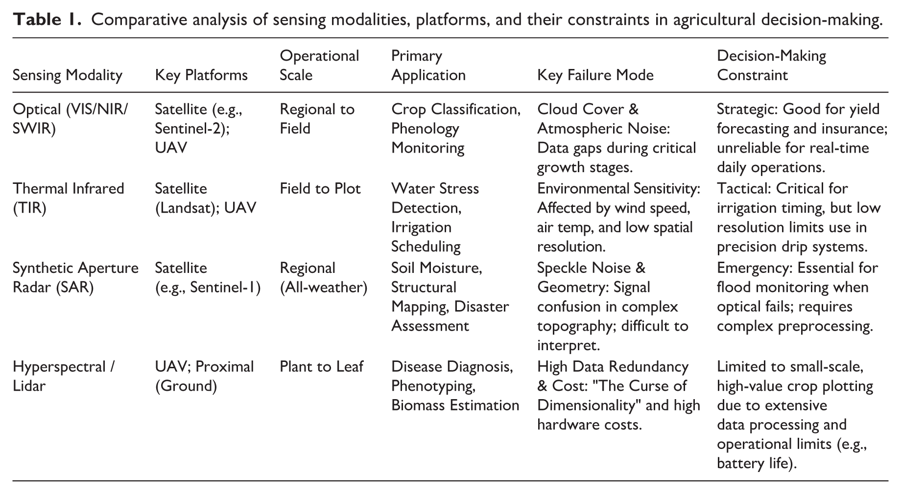
Furthermore, the choice of platform dictates the scale of decision-making. Satellite-based systems support strategic planning (e.g., regional crop planting structure adjustment) due to their extensive coverage but often lack the spatial resolution required for tactical management (e.g., variable-rate spraying for individual plants). Conversely, UAV and proximal sensing offer sub-centimeter resolution ideal for precision breeding and disease diagnosis but are constrained by battery life and data processing costs, limiting their application to small-scale, high-value plotting. Table 1 systematically outlines these trade-offs to guide researcher and practitioner selection.
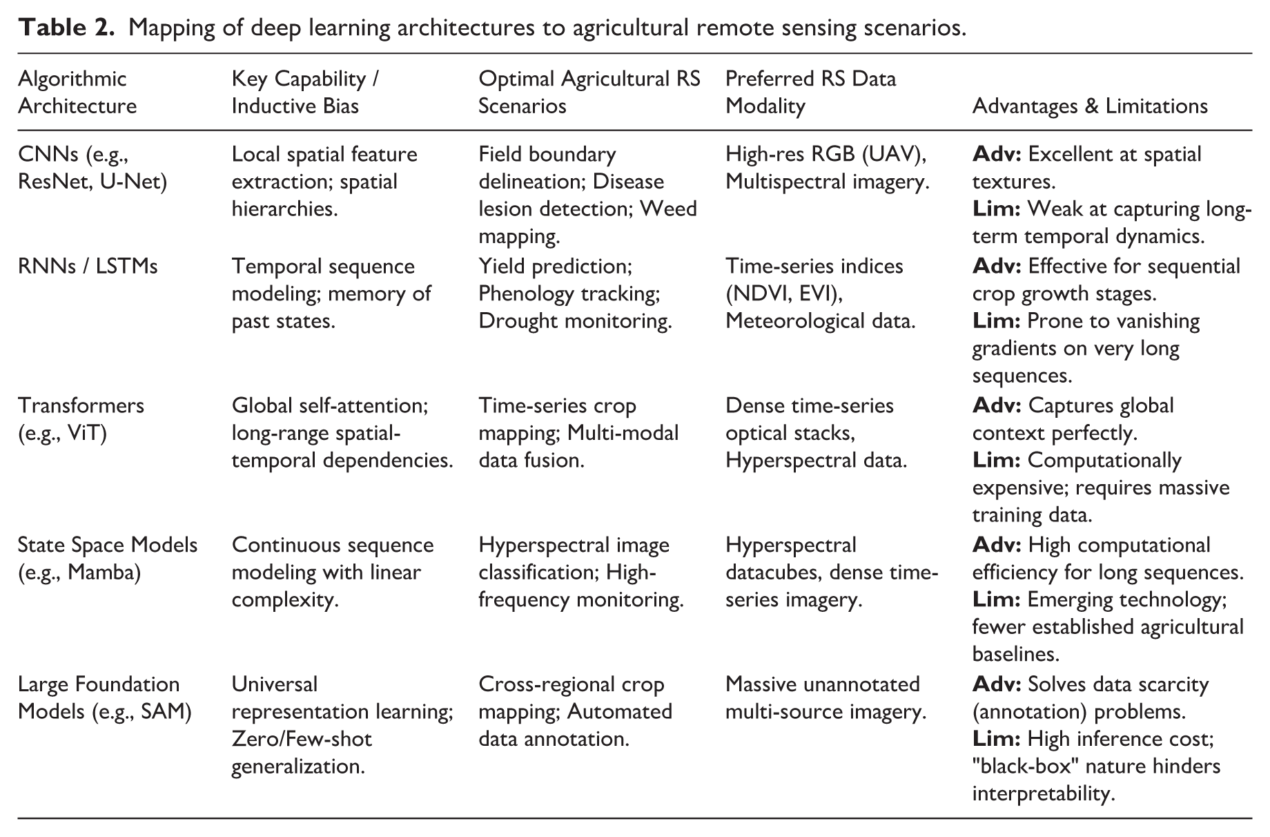
Mapping algorithmic architectures to agricultural scenarios
While previous sections outlined machine learning applications from an agronomic perspective, matching these scenarios with appropriate algorithmic architectures is equally critical for effective remote sensing analysis. Different network architectures possess distinct inductive biases suited for specific spatial, temporal, and spectral complexities. For instance, Convolutional Neural Networks (CNNs) are the dominant architecture for spatial pattern recognition tasks, such as fine-scale field boundary delineation and localized disease detection using high-resolution imagery (Too et al., 2019). Conversely, for temporal sequence modeling—such as yield prediction and phenology tracking—Recurrent Neural Networks (RNNs) and Long Short-Term Memory (LSTM) networks are preferred due to their ability to capture temporal dependencies from time-series indices and meteorological data (Schwalbert et al., 2020).
Recent advancements have introduced more sophisticated architectures to overcome the limitations of early deep learning models. Transformers, leveraging spatiotemporal self-attention mechanisms, have demonstrated exceptional capability for handling long-range dependencies in complex tasks such as crop classification from time-series data, bypassing the sequential processing bottlenecks of LSTMs (Wang et al., 2024b). Furthermore, emerging State Space Models, such as Mamba, offer a paradigm shift by maintaining global receptive fields with linear computational complexity. In agricultural remote sensing, Mamba architectures are showing immense potential for processing continuous, ultra-long time-series satellite data and complex hyperspectral datacubes without prohibitive memory overhead (He et al., 2024). Finally, the advent of Vision Foundation Models (VFMs) is transitioning agricultural remote sensing toward a “pre-train, fine-tune” paradigm. Models leveraging massive unannotated Earth observation data exhibit remarkable zero-shot and few-shot generalization capabilities, mitigating the pervasive data scarcity and annotation bottlenecks in agriculture (Osco et al., 2023). To systematically guide algorithm selection, Table 2 maps these core architectures to their optimal agricultural remote sensing scenarios.
Mapping of deep learning architectures to agricultural remote sensing scenarios.
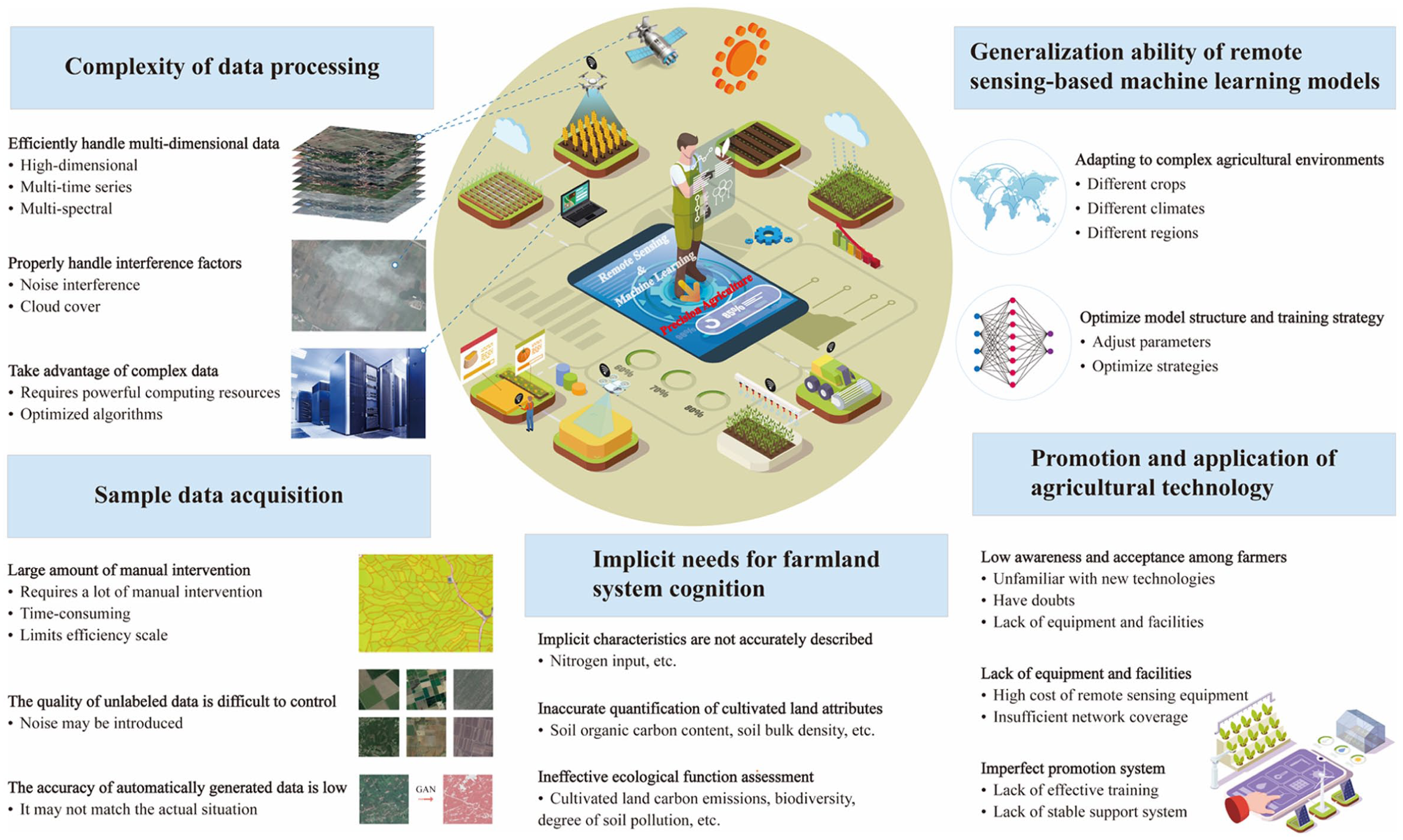
Challenges and future perspectives
To provide a structured roadmap for future research, we categorize the following challenges into three hierarchical priorities based on their urgency and impact mechanism. First, Cognitive Barriers (Fundamental Priority, Section “Cognizing the Complexity of Arable Land Systems”) represent the root cause of our inability to understand complex system dynamics. Second, Technical Bottlenecks (Immediate Priority, Sections 3.2–3.4)—including data spatiotemporal mismatch, model generalization, and sampling costs—require urgent methodological breakthroughs. Finally, Socio-technical Barriers (Long-term Priority, Section 3.5) dictate the ultimate scalability and sustainability of these technologies. The specific constraints and actionable directions for each priority are detailed below.
Cognizing the complexity of arable land systems
The fundamental challenge in precision agriculture lies in cognizing the arable land system not merely as a static surface for production, but as a complex adaptive system driven by the dynamic coupling of natural resources and human activities. As illustrated in the cascade process of Figure 2, human behaviors—ranging from excessive fertilizer input and heavy machinery operation to mono-cropping patterns—interact continuously with the arable land entity (soil, water, and biota) to drive nonlinear changes in ecological functions. While current remote sensing technologies have achieved high accuracy in depicting "explicit" characteristics such as land use types and landscape fragmentation, they face substantial methodological hurdles in characterizing the “recessive” attributes generated through this cascade. Specifically, quantifying invisible parameters like nitrogen input intensity, soil organic carbon dynamics, and biodiversity loss remains difficult because these attributes do not have unique spectral signatures but are indirect consequences of complex "Human-Land" interactions (Du et al., 2024; Ren et al., 2025). Unlike visible surface features, these recessive attributes often require inverting complex radiative transfer models that are easily confounded by environmental noise. Consequently, accurately capturing the boundary of abrupt changes in ecological functions necessitates constructing high-dimensional, long-term datasets that can decouple these complex interactions, a task that traditional optical sensing alone struggles to achieve.
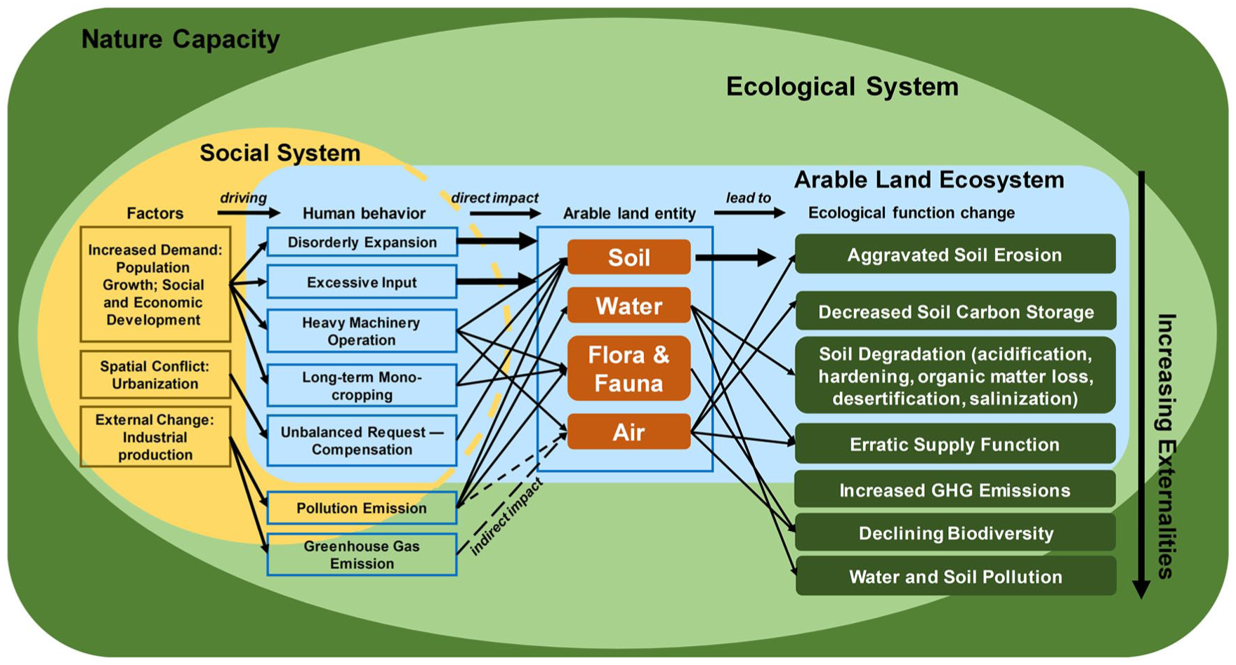
Cascade process between human behavior - arable land entity - ecological function change in arable land ecosystem.
Spatiotemporal mismatch and data complexity
Remote sensing systems are inherently complex, focusing on data acquisition and analysis that involve high-dimensional, multi-temporal, and multi-spectral features capturing variables across diverse spatiotemporal scales (Im and Jensen, 2008; Lillesand et al., 2015). However, a critical constraint specific to agriculture is the spatiotemporal mismatch between satellite revisit cycles and rapid crop phenological transitions. Agricultural monitoring requires high-frequency observations to capture subtle physiological changes during critical growth windows, such as flowering or grain filling. Unfortunately, remote sensing imagery is frequently compromised by interference factors like atmospheric noise and persistent cloud cover during these peak growing seasons (Ju and Roy, 2008; Xu et al., 2019), resulting in the loss of critical spectral data that cannot simply be resolved by interpolation techniques. Although machine learning models, particularly deep learning, have shown promise in processing these heterogeneous datasets by learning non-linear representations (Yuan et al., 2020), fully utilizing such complex data requires powerful computing resources and optimized algorithms to reconstruct continuous growth trajectories from fragmented observations (Han et al., 2023). Future research must focus on fusing multi-source data to mitigate these interference factors, thereby bridging the gap between discrete static observations and the continuous dynamic nature of crop physiology.
Model generalization under heterogeneous agro-environments
The scalability of machine learning models in agriculture is currently hindered by the “Genotype × Environment × Management” (G×E×M) interaction, a challenge specific to biological systems that transcends standard computer vision problems. A model trained effectively in one region often fails to generalize to another, not merely due to statistical domain shifts, but because identical crop varieties exhibit varying spectral signatures under different soil textures, moisture levels, and microclimates. This issue is exacerbated in smallholder farming systems characterized by landscape fragmentation, where the prevalence of mixed pixels challenges the extraction of pure phenotypic traits. Improving the generalization ability of models to adapt to these diverse agricultural conditions is key to achieving precision management (Zheng et al., 2021). While emerging techniques such as transfer learning (Li et al., 2021) and semi-supervised learning (Amorim et al., 2019) offer new pathways to reduce dependence on labeled data by transferring knowledge across domains, their robustness in complex, fragmented agricultural landscapes remains to be fully validated. Developing domain-adaptive algorithms that can decouple crop-specific features from environmental background noise, or "invariant feature learning," remains a priority for future research to ensure models are robust across varying agro-climatic zones.
High-cost of agronomic ground-truthing and sampling
High-quality sample data is essential for machine learning models to make reliable predictions, yet data scarcity in agriculture differs fundamentally from other domains. Obtaining high-quality “ground truth” often necessitates destructive sampling and rigorous laboratory analysis (e.g., measuring leaf chlorophyll content or soil nutrient concentrations), which is far more labor-intensive, time-consuming, and costly than the simple visual bounding-box annotation used in general object detection (Russell et al., 2008). This reliance on manual intervention severely limits the efficiency and scale of agricultural data processing. To address this bottleneck, scholars are actively exploring methods to utilize unlabeled data (Zhang et al., 2023) or employ Generative Adversarial Networks (GANs) to automatically generate synthetic training samples (Lu et al., 2022). However, the quality of unlabeled data is difficult to guarantee, and discrepancies between synthetic data and the complex reality of field conditions often introduce noise that degrades model performance. Therefore, future research should prioritize integrating active learning strategies—which intelligently select the most informative samples for manual annotation—with small-sample learning techniques to maximize prediction accuracy while minimizing the cost and effort of agronomic ground-truthing.
Socio-technical barriers and institutional support
Despite the significant potential of integrating machine learning and remote sensing to transform agricultural production (Benos et al., 2021), the adoption gap is increasingly recognized as a structural socio-technical barrier rather than a purely cognitive one. The implementation of real-time monitoring and precise management is fundamentally constrained by the “digital divide,” characterized by insufficient rural network infrastructure and the high capital intensity of advanced sensing equipment (Mhlanga and Ndhlovu, 2023). Many farmers harbor doubts regarding the reliability and cost-effectiveness of these tools, stemming not solely from a lack of knowledge or "fear of the unknown," but from the absence of clear economic safety nets and return-on-investment models (Khaspuria et al., 2024). Consequently, widespread adoption necessitates a paradigm shift from placing the burden on individual farmers toward government-led institutional support. This includes expanding rural digital infrastructure, providing financial subsidies to mitigate adoption risks, and establishing socialized agricultural service platforms. Such institutional frameworks are essential to simplify technology operation and provide the long-term technical training mechanisms needed to bridge the gap between advanced algorithms and practical field management.
Conclusion
The combination of machine learning and remote sensing technology brings significant potential for advancing precision agriculture. In areas such as crop monitoring and growth prediction, soil health assessment and management, pest detection and control, disaster monitoring and extreme weather prediction, and agricultural resource optimization management, these technologies demonstrate their capability to enhance agricultural productivity, promote sustainable development, and address the challenges of global population growth and resource scarcity. However, to fully realize the advantages of this combination, several challenges need to be addressed. The complexity of data processing requires advanced computing resources and optimized algorithms to handle the high-dimensional, multi-temporal, and multispectral characteristics of remote sensing data, as well as interference factors like noise and cloud cover. Improving the generalization ability of machine learning models is essential for adapting to different agricultural conditions; although transfer learning and semi-supervised learning provide promising directions, further optimization is still needed. Obtaining high-quality sample data and annotations is a challenge, and methods such as using unlabeled data and automatically generating annotated data need improvement. Additionally, promoting these technologies in real agricultural production faces challenges such as farmers' unfamiliarity with new technologies, a lack of equipment and infrastructure, and insufficient network coverage in rural areas. To overcome these challenges, future research should focus on developing more efficient data processing methods, improving model generalization capabilities, refining data annotation and acquisition techniques, and promoting the wider adoption and application of these technologies through measures such as simplifying technology, reducing costs, and providing effective training. The government, research institutions, and enterprises must work together to establish a long-term stable training mechanism and technical support system. By addressing these challenges, the combination of machine learning and remote sensing technology can play a key role in promoting agricultural modernization and sustainable development.
Footnotes
Acknowledgements
Author contributions
Yao Xiaochuang, Conceptualization; Visualization; Writing – original draft; Writing – review & editing. Xu Fan, Data curation; Visualization; Writing – original draft. Ye Sijing, Conceptualization; Formal analysis; Visualization; Writing – original draft; Writing – review & editing; Supervision; Project administration; Funding acquisition; Resources.
Funding
The authors disclosed receipt of the following financial support for the research, authorship, and/or publication of this article: This research was funded by National Natural Science Foundation of China [Grant No. 42571308, 42371281, 42171250, 42230106].
Declaration of conflicting interests
The authors declared no potential conflicts of interest with respect to the research, authorship, and/or publication of this article.